
An Improved Accessibility-Based Model to Evaluate Educational Equity: A Case Study in the City of Wuhan

Abstract
:1. Introduction
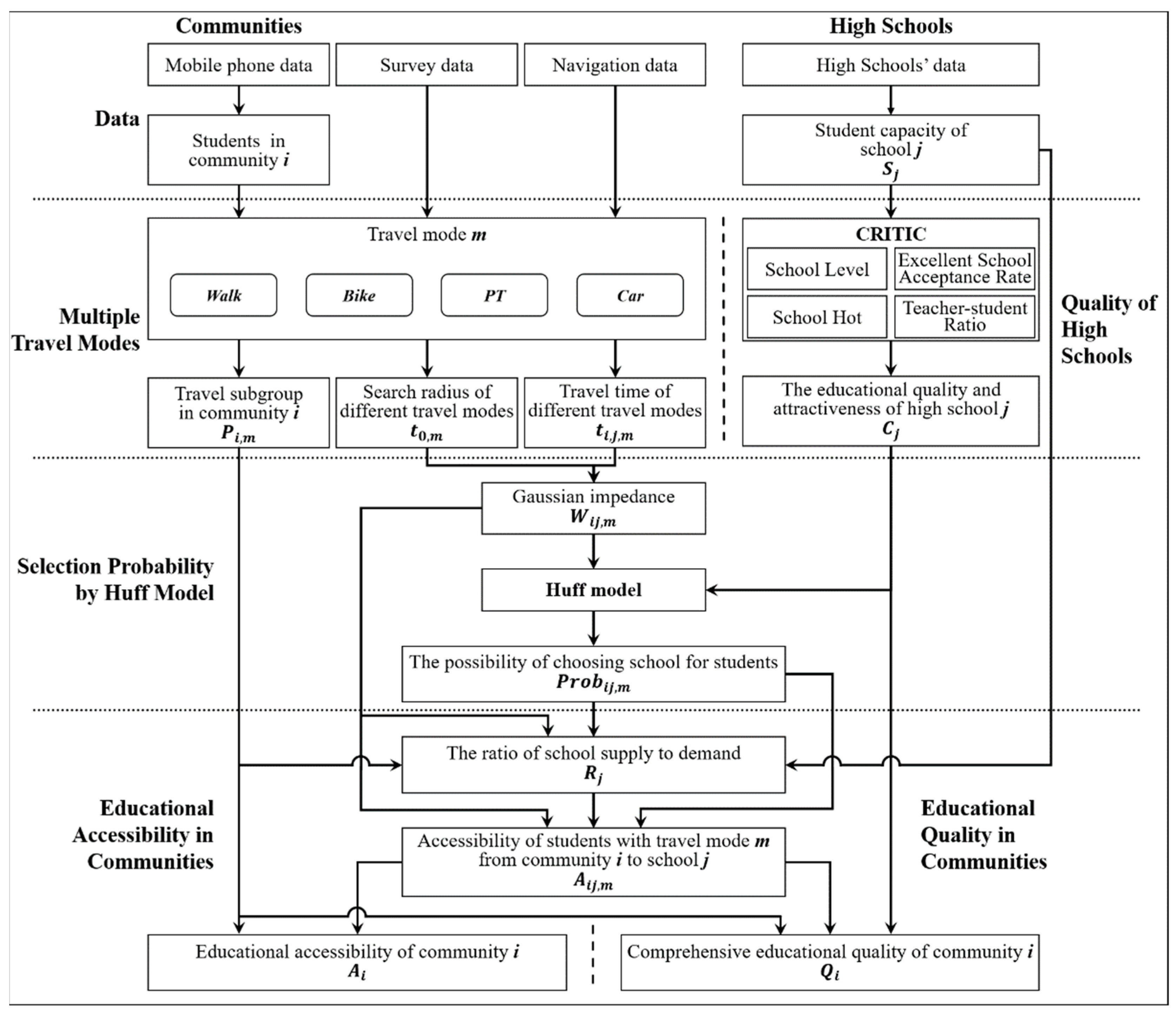
2. Methods
2.1. Quality of High Schools
2.2. Multiple Travel Modes
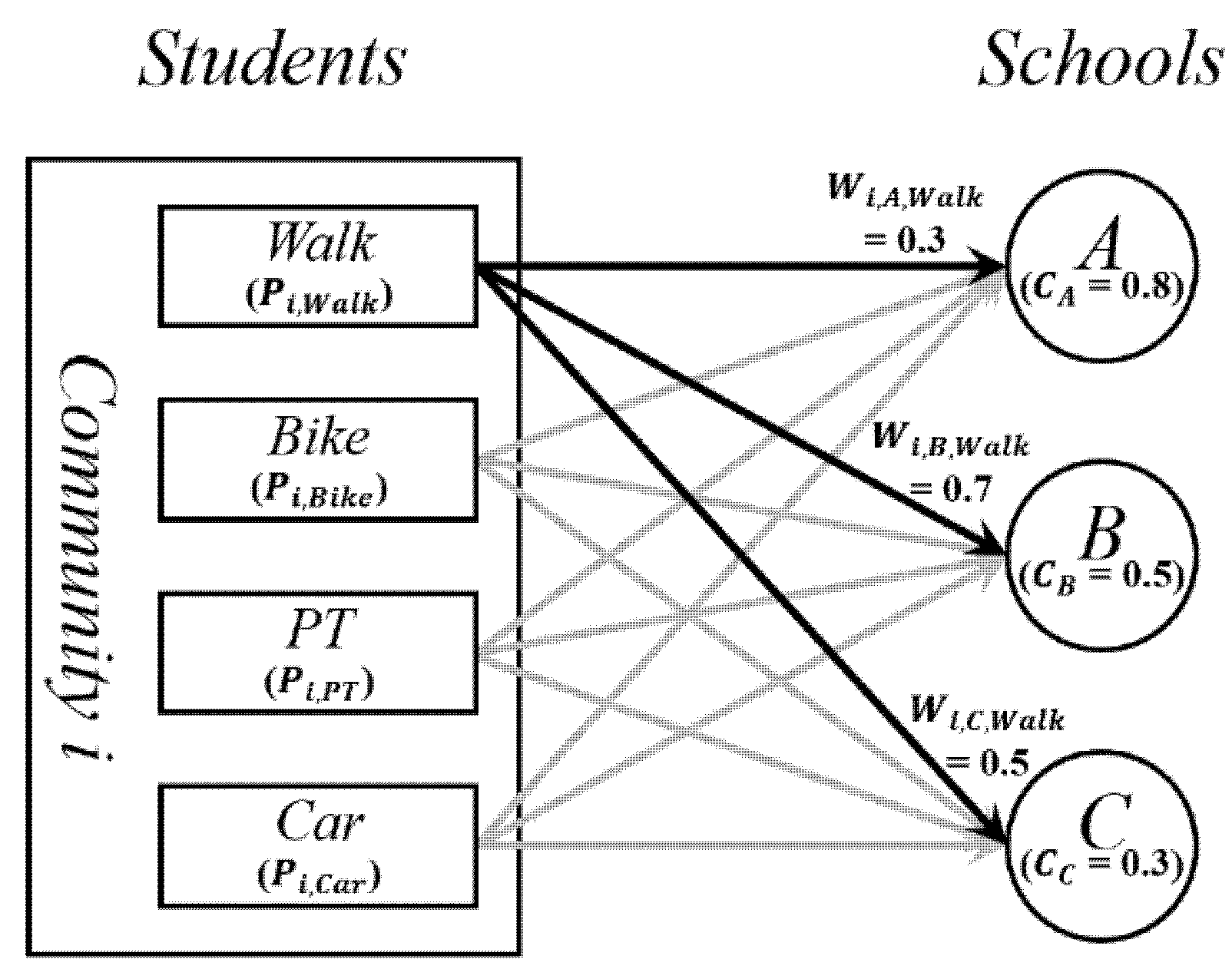
2.3. Selection Probability by the Huff Model
2.4. Educational Accessibility in Communities
2.5. Educational Quality in Communities
3. Case Study: Access to High Schools for Students in Wuhan
3.1. Study Area
3.2. Data
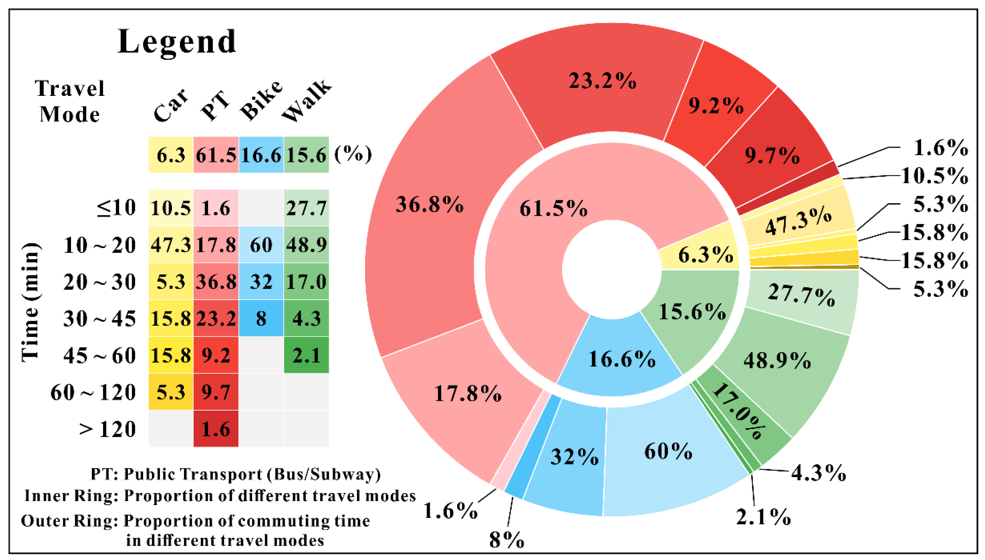
3.2.1. Survey on Students’ Travel Modes
3.2.2. Travel Times for Different Travel Modes
4. Results
4.1. Comparative Analysis
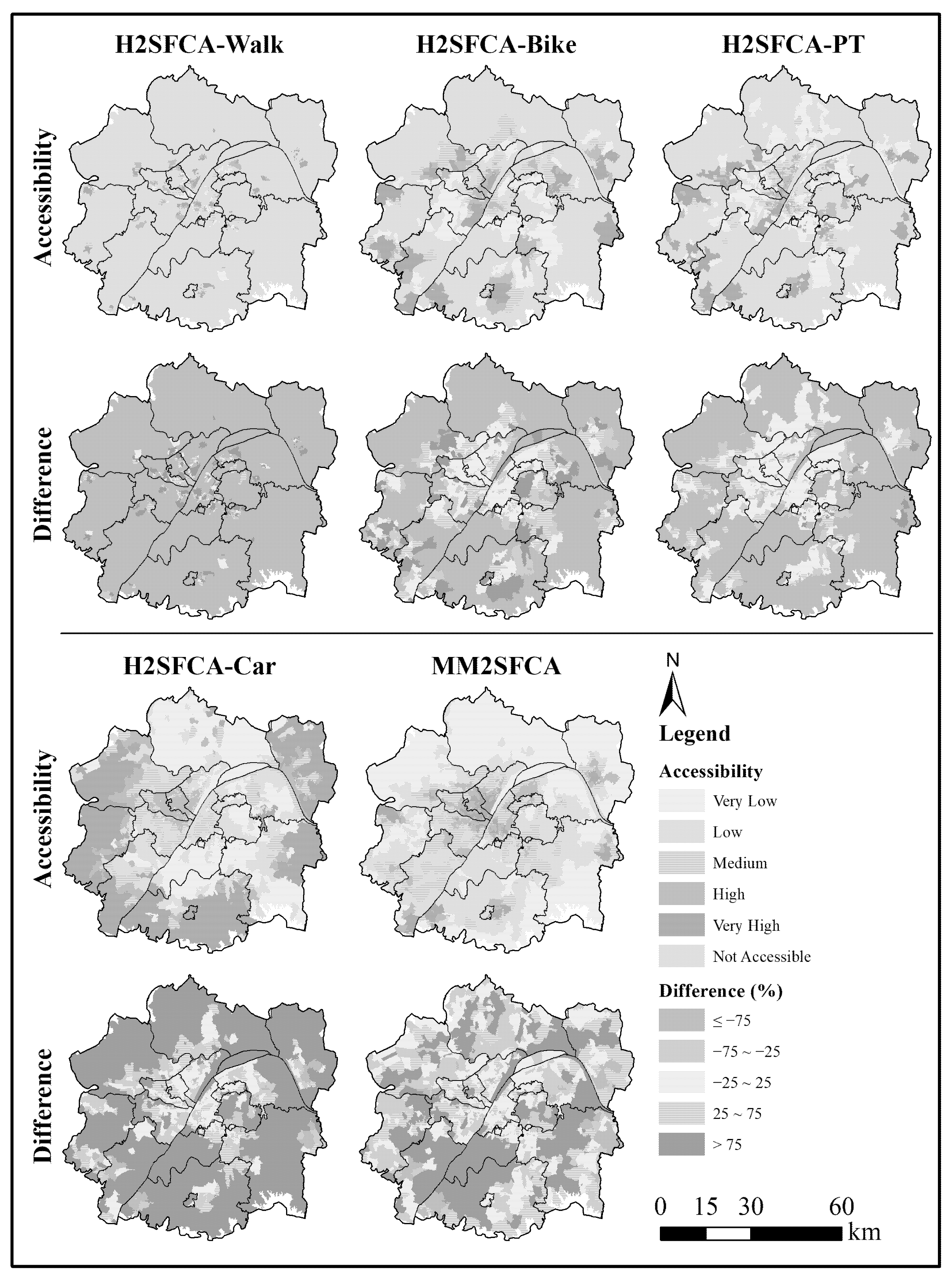
4.1.1. Accessibility Comparison
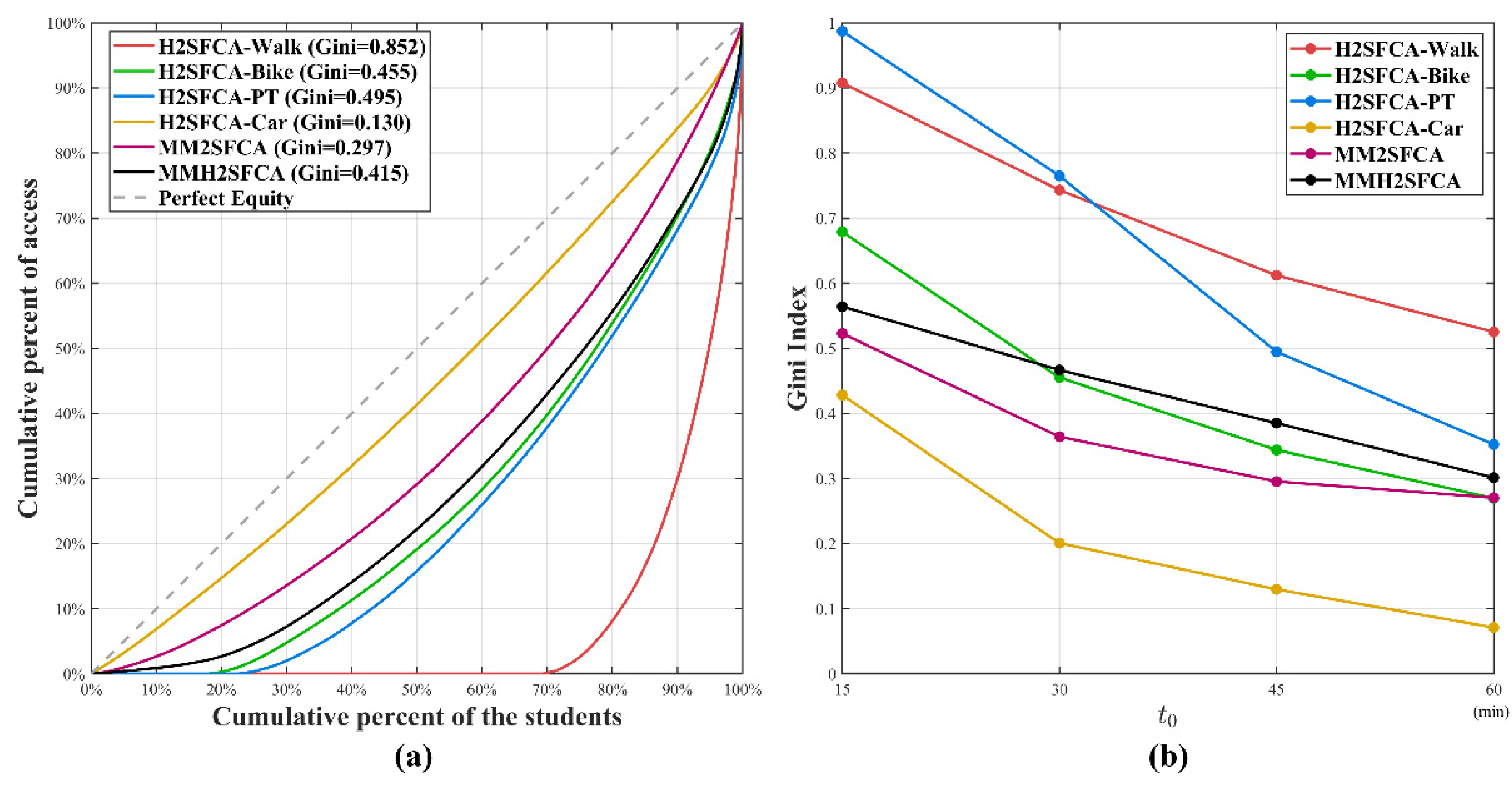
4.1.2. Gini Coefficient Comparison
4.2. Educational Accessibility and Quality
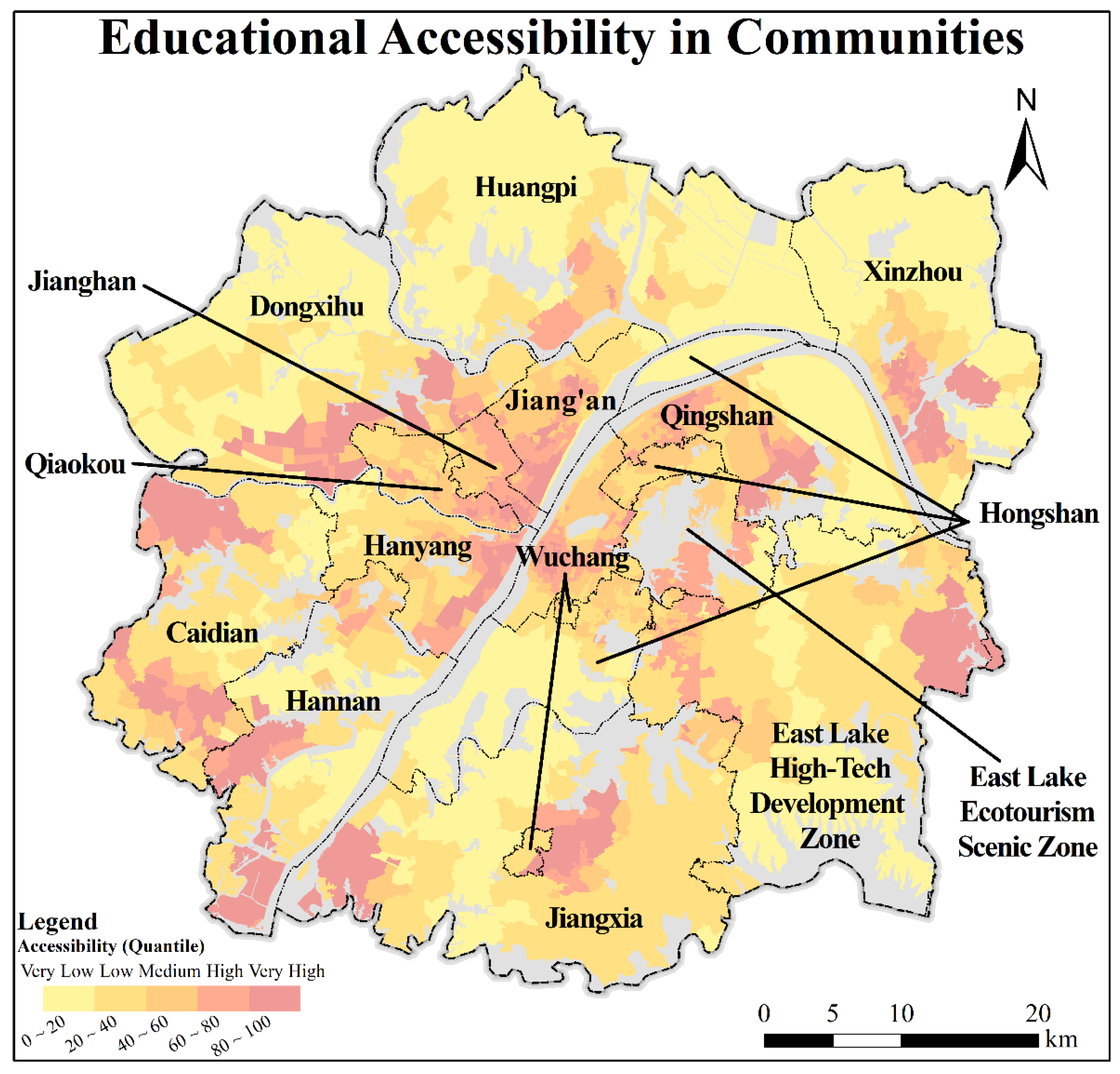
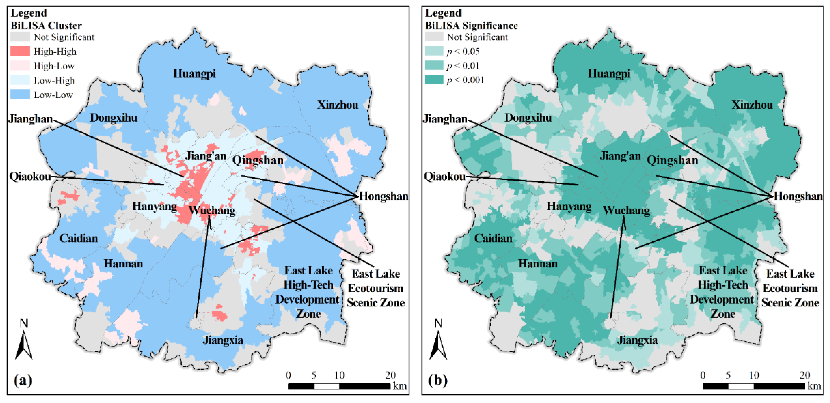
4.2.1. Spatial Distribution and Descriptive Statistics
4.2.2. Correlation Analysis
5. Discussion
5.1. Discussion on the Comparison of Methods
5.1.1. Comparison with the H2SFCA Method
5.1.2. Comparison with the MM2SFCA Method
5.1.3. Advantages of Our Proposed Method
5.2. Implications and Recommendations
5.3. Limitations
6. Conclusions
Author Contributions
Funding
Data Availability Statement
Conflicts of Interest
Appendix A
- What is your gender?
- Male
- Female
- What is your age? (Please fill in your age value.)
- Where are you from? (Please select a specific province-city-district.)
- Where is your high school? (Please select a specific province-city-district, if you do not attend high school, please select your birthplace.)
- What is your usual way to go to school in high school? (If you have never been to high school, please select “Other”.)
- Walking
- Bicycle/Electric vehicle
- Bus/Subway
- Private car
- Other
- What is your average time on the way to school in high school? (If you have never been to high school, please choose the usual commuting time.)
- Less than 10 min
- 10–20 min
- 20–30 min
- 30–45 min
- 45–60 min
- 1–2 h
- More than 2 h
- What is your usual way of commuting to work/school?
- Walking
- Bicycle/Electric vehicle
- Bus/Subway
- Private car
- Other
- What is the average time you spend on your way to work/school?
- Less than 10 min
- 10–20 min
- 20–30 min
- 30–45 min
- 45–60 min
- 1–2 h
- More than 2 h
References
- UNESCO. Education 2030: Incheon Declaration and Framework for Action for the implementation of Sustainable Development Goal 4: Ensure Inclusive and Equitable Quality Education and Promote Lifelong Learning Opportunities for All; United Nations Educational, Scientific and Cultural Organization: Paris, France, 2016; p. 86. [Google Scholar]
- Gao, Y.; He, Q.; Liu, Y.; Zhang, L.; Wang, H.; Cai, E. Imbalance in Spatial Accessibility to Primary and Secondary Schools in China: Guidance for Education Sustainability. Sustainability 2016, 8, 1236. [Google Scholar] [CrossRef] [Green Version]
- Zhao, D.; Parolin, B. Merged or Unmerged School? School Preferences in the Context of School Mapping Restructure in Rural China. Asia Pac. Educ. Res. 2013, 23, 547–563. [Google Scholar] [CrossRef]
- Vaught, S.E. The Color of Money: School Funding and the Commodification of Black Children. Urban Educ. 2009, 44, 545–570. [Google Scholar] [CrossRef]
- Knight, D.S. Are School Districts Allocating Resources Equitably? The Every Student Succeeds Act, Teacher Experience Gaps, and Equitable Resource Allocation. Educ. Policy 2017, 33, 615–649. [Google Scholar] [CrossRef] [Green Version]
- Halai, A. Equality or equity: Gender awareness issues in secondary schools in Pakistan. Int. J. Educ. Dev. 2011, 31, 44–49. [Google Scholar] [CrossRef]
- Meschi, E.; Scervini, F. A new dataset on educational inequality. Empir. Econ. 2014, 47, 695–716. [Google Scholar] [CrossRef]
- Kyriakides, L.; Creemers, B.P.; Charalambous, E. Searching for differential teacher and school effectiveness in terms of student socioeconomic status and gender: Implications for promoting equity. Sch. Eff. Sch. Improv. 2018, 30, 286–308. [Google Scholar] [CrossRef]
- Luo, Y.; Zhou, R.Y.; Mizunoya, S.; Amaro, D. How various types of disabilities impact children’s school attendance and completion—Lessons learned from censuses in eight developing countries. Int. J. Educ. Dev. 2020, 77, 102222. [Google Scholar] [CrossRef]
- Van Dyk, H.; White, C. Theory and practice of the quintile ranking of schools in South Africa: A financial management perspective. South. Afr. J. Educ. 2019, 39, S1–S9. [Google Scholar] [CrossRef]
- Caner, H.A.; Bayhan, S. High-stakes examination policies and transformation of the Turkish education system. Int. J. Educ. Dev. 2020, 79, 102263. [Google Scholar] [CrossRef]
- Zhang, J.; Li, H.; Lin, J.; Zheng, W.; Li, H.; Chen, Z. Meta-analysis of the relationship between high quality basic education resources and housing prices. Land Use Policy 2020, 99, 104843. [Google Scholar] [CrossRef]
- Hu, L.; He, S.; Luo, Y.; Su, S.; Xin, J.; Weng, M. A social-media-based approach to assessing the effectiveness of equitable housing policy in mitigating education accessibility induced social inequalities in Shanghai, China. Land Use Policy 2020, 94, 104513. [Google Scholar] [CrossRef]
- Wen, H.; Xiao, Y.; Zhang, L. School district, education quality, and housing price: Evidence from a natural experiment in Hangzhou, China. Cities 2017, 66, 72–80. [Google Scholar] [CrossRef]
- Hu, W.; Wang, R. Segregation in urban education: Evidence from public schools in Shanghai, China. Cities 2019, 87, 106–113. [Google Scholar] [CrossRef]
- Churchill, S.A.; Smyth, R. Transport poverty and subjective wellbeing. Transp. Res. Part A Policy Pr. 2019, 124, 40–54. [Google Scholar] [CrossRef]
- Allen, J.; Farber, S. Planning transport for social inclusion: An accessibility-activity participation approach. Transp. Res. Part D Transp. Environ. 2020, 78, 102212. [Google Scholar] [CrossRef]
- Wang, H.; Kwan, M.-P.; Hu, M. Social exclusion and accessibility among low- and non-low-income groups: A case study of Nanjing, China. Cities 2020, 101, 102684. [Google Scholar] [CrossRef]
- Tsou, K.-W.; Hung, Y.-T.; Chang, Y.-L. An accessibility-based integrated measure of relative spatial equity in urban public facilities. Cities 2005, 22, 424–435. [Google Scholar] [CrossRef]
- Xing, L.; Liu, Y.; Wang, B.; Wang, Y.; Liu, H. An environmental justice study on spatial access to parks for youth by using an improved 2SFCA method in Wuhan, China. Cities 2020, 96, 102405. [Google Scholar] [CrossRef]
- Dai, D. Black residential segregation, disparities in spatial access to health care facilities, and late-stage breast cancer diagnosis in metropolitan Detroit. Health Place 2010, 16, 1038–1052. [Google Scholar] [CrossRef] [PubMed]
- Dai, D. Racial/ethnic and socioeconomic disparities in urban green space accessibility: Where to intervene? Landsc. Urban Plan. 2011, 102, 234–244. [Google Scholar] [CrossRef]
- Kunzmann, K.R. Planning for spatial equity in Europe. Int. Plan. Stud. 1998, 3, 101–120. [Google Scholar] [CrossRef]
- Ashik, F.R.; Alam Mim, S.; Neema, M.N. Towards vertical spatial equity of urban facilities: An integration of spatial and aspatial accessibility. J. Urban Manag. 2020, 9, 77–92. [Google Scholar] [CrossRef]
- Litman, T. Evaluating Transportation Equity: Guidance for Incorporating Distributional Impacts in Transportation Planning; Victoria Transport Policy Institute: Victoria, British, 2006; p. 8. [Google Scholar]
- Ricciardi, A.M.; Xia, J.; Currie, G. Exploring public transport equity between separate disadvantaged cohorts: A case study in Perth, Australia. J. Transp. Geogr. 2015, 43, 111–122. [Google Scholar] [CrossRef]
- Wang, S.-I.; Yaung, C.-L. Vertical equity of healthcare in Taiwan: Health services were distributed according to need. Int. J. Equity Health 2013, 12, 12. [Google Scholar] [CrossRef] [PubMed] [Green Version]
- Yuan, Y.; Xu, J.; Wang, Z. Spatial Equity Measure on Urban Ecological Space Layout Based on Accessibility of Socially Vulnerable Groups—A Case Study of Changting, China. Sustainability 2017, 9, 1552. [Google Scholar] [CrossRef] [Green Version]
- Dadashpoor, H.; Rostami, F.; Alizadeh, B. Is inequality in the distribution of urban facilities inequitable? Exploring a method for identifying spatial inequity in an Iranian city. Cities 2016, 52, 159–172. [Google Scholar] [CrossRef]
- Chen, Z.; Guo, Y.; Stuart, A.L.; Zhang, Y.; Li, X. Exploring the equity performance of bike-sharing systems with disaggregated data: A story of southern Tampa. Transp. Res. Part A Policy Pr. 2019, 130, 529–545. [Google Scholar] [CrossRef] [Green Version]
- Panagiotopoulos, G.; Kaliampakos, D. Accessibility and Spatial Inequalities in Greece. Appl. Spat. Anal. Policy 2018, 12, 567–586. [Google Scholar] [CrossRef]
- Guo, S.; Song, C.; Pei, T.; Liu, Y.; Ma, T.; Du, Y.; Chen, J.; Fan, Z.; Tang, X.; Peng, Y.; et al. Accessibility to urban parks for elderly residents: Perspectives from mobile phone data. Landsc. Urban Plan. 2019, 191, 103642. [Google Scholar] [CrossRef]
- Rosas-Satizábal, D.; Guzman, L.A.; Oviedo, D. Cycling diversity, accessibility, and equality: An analysis of cycling commuting in Bogotá. Transp. Res. Part D Transp. Environ. 2020, 88, 102562. [Google Scholar] [CrossRef]
- Palm, M.; Farber, S. The role of public transit in school choice and after-school activity participation among Toronto high school students. Travel Behav. Soc. 2020, 19, 219–230. [Google Scholar] [CrossRef]
- Chen, N.; Wang, C.-H. Does green transportation promote accessibility for equity in medium-size U.S. cites? Transp. Res. Part D Transp. Environ. 2020, 84, 102365. [Google Scholar] [CrossRef]
- Kelobonye, K.; Zhou, H.; McCarney, G.; Xia, J. (Cecilia) Measuring the accessibility and spatial equity of urban services under competition using the cumulative opportunities measure. J. Transp. Geogr. 2020, 85, 102706. [Google Scholar] [CrossRef]
- Taleai, M.; Sliuzas, R.; Flacke, J. An integrated framework to evaluate the equity of urban public facilities using spatial multi-criteria analysis. Cities 2014, 40, 56–69. [Google Scholar] [CrossRef]
- Hansen, W.G. How Accessibility Shapes Land Use. J. Am. Inst. Plan. 1959, 25, 73–76. [Google Scholar] [CrossRef]
- Saurman, E. Improving access: Modifying Penchansky and Thomas’s Theory of Access. J. Health Serv. Res. Policy 2016, 21, 36–39. [Google Scholar] [CrossRef] [PubMed]
- Bantis, T.; Haworth, J. Assessing transport related social exclusion using a capabilities approach to accessibility framework: A dynamic Bayesian network approach. J. Transp. Geogr. 2020, 84, 102673. [Google Scholar] [CrossRef]
- Vallée, J.; Shareck, M.; Le Roux, G.; Kestens, Y.; Frohlich, K.L. Is accessibility in the eye of the beholder? Social inequalities in spatial accessibility to health-related resources in Montréal, Canada. Soc. Sci. Med. 2020, 245, 112702. [Google Scholar] [CrossRef]
- Moore, L.V.; Roux, A.V.D.; Evenson, K.R.; McGinn, A.P.; Brines, S.J. Availability of Recreational Resources in Minority and Low Socioeconomic Status Areas. Am. J. Prev. Med. 2008, 34, 16–22. [Google Scholar] [CrossRef]
- Boone, C.G.; Buckley, G.L.; Grove, J.M.; Sister, C. Parks and People: An Environmental Justice Inquiry in Baltimore, Maryland. Ann. Assoc. Am. Geogr. 2009, 99, 767–787. [Google Scholar] [CrossRef]
- Yang, L.; Wang, B.; Zhou, J.; Wang, X. Walking accessibility and property prices. Transp. Res. Part D Transp. Environ. 2018, 62, 551–562. [Google Scholar] [CrossRef]
- Hu, L. Racial/ethnic differences in job accessibility effects: Explaining employment and commutes in the Los Angeles region. Transp. Res. Part D Transp. Environ. 2019, 76, 56–71. [Google Scholar] [CrossRef]
- Luo, W.; Wang, F. Measures of Spatial Accessibility to Health Care in a GIS Environment: Synthesis and a Case Study in the Chicago Region. Environ. Plan. B Plan. Des. 2003, 30, 865–884. [Google Scholar] [CrossRef] [PubMed] [Green Version]
- Luo, W.; Qi, Y. An enhanced two-step floating catchment area (E2SFCA) method for measuring spatial accessibility to primary care physicians. Health Place 2009, 15, 1100–1107. [Google Scholar] [CrossRef]
- Mao, L.; Nekorchuk, D. Measuring spatial accessibility to healthcare for populations with multiple transportation modes. Health Place 2013, 24, 115–122. [Google Scholar] [CrossRef]
- Luo, J. Integrating the Huff Model and Floating Catchment Area Methods to Analyze Spatial Access to Healthcare Services. Trans. GIS 2014, 18, 436–448. [Google Scholar] [CrossRef]
- Tao, Z.; Cheng, Y.; Dai, T.; Rosenberg, M.W. Spatial optimization of residential care facility locations in Beijing, China: Maximum equity in accessibility. Int. J. Health Geogr. 2014, 13, 33. [Google Scholar] [CrossRef] [Green Version]
- Dai, D.; Wang, F. Geographic disparities in accessibility to food stores in southwest Mississippi. Environ. Plan. B Plan. Des. 2011, 38, 659–677. [Google Scholar] [CrossRef]
- Luo, W.; Whippo, T. Variable catchment sizes for the two-step floating catchment area (2SFCA) method. Health Place 2012, 18, 789–795. [Google Scholar] [CrossRef]
- McGrail, M.R.; Humphreys, J.S. Measuring spatial accessibility to primary health care services: Utilising dynamic catchment sizes. Appl. Geogr. 2014, 54, 182–188. [Google Scholar] [CrossRef]
- Wan, N.; Zou, B.; Sternberg, T. A three-step floating catchment area method for analyzing spatial access to health services. Int. J. Geogr. Inf. Sci. 2012, 26, 1073–1089. [Google Scholar] [CrossRef]
- Fransen, K.; Neutens, T.; De Maeyer, P.; Deruyter, G. A commuter-based two-step floating catchment area method for measuring spatial accessibility of daycare centers. Health Place 2015, 32, 65–73. [Google Scholar] [CrossRef]
- Ma, X.; Ren, F.; Du, Q.; Liu, P.; Li, L.; Xi, Y.; Jia, P. Incorporating multiple travel modes into a floating catchment area framework to analyse patterns of accessibility to hierarchical healthcare facilities. J. Transp. Health 2019, 15, 100675. [Google Scholar] [CrossRef]
- Zhou, X.; Yu, Z.; Yuan, L.; Wang, L.; Wu, C. Measuring Accessibility of Healthcare Facilities for Populations with Multiple Transportation Modes Considering Residential Transportation Mode Choice. ISPRS Int. J. Geo Inf. 2020, 9, 394. [Google Scholar] [CrossRef]
- Cao, H. Spatial inequality in children’s schooling in Gansu, Western China: Reality and challenges. Can. Geogr. 2008, 52, 331–350. [Google Scholar] [CrossRef]
- Behbahani, H.; Nazari, S.; Kang, M.J.; Litman, T. A conceptual framework to formulate transportation network design problem considering social equity criteria. Transp. Res. Part A Policy Pr. 2019, 125, 171–183. [Google Scholar] [CrossRef]
- Kelobonye, K.; McCarney, G.; Xia, J.; Swapan, M.S.H.; Mao, F.; Zhou, H. Relative accessibility analysis for key land uses: A spatial equity perspective. J. Transp. Geogr. 2019, 75, 82–93. [Google Scholar] [CrossRef]
- Williams, S.; Fahui, W. Disparities in accessibility of public high schools, in metropolitan Baton Rouge, Louisiana 1990–2010. Urban Geogr. 2014, 35, 1066–1083. [Google Scholar] [CrossRef]
- Singleton, A.D.; Longley, P.A.; Allen, R.; O’Brien, O. Estimating secondary school catchment areas and the spatial equity of access. Comput. Environ. Urban Syst. 2011, 35, 241–249. [Google Scholar] [CrossRef]
- Boussauw, K.; van Meeteren, M.; Witlox, F. Short trips and central places: The home-school distances in the Flemish primary education system (Belgium). Appl. Geogr. 2014, 53, 311–322. [Google Scholar] [CrossRef] [Green Version]
- Boterman, W.; Musterd, S.; Pacchi, C.; Ranci, C. School segregation in contemporary cities: Socio-spatial dynamics, institutional context and urban outcomes. Urban Stud. 2019, 56, 3055–3073. [Google Scholar] [CrossRef]
- Scott, M.R.; Marshall, D.T. Public Transit and School Choice in Philadelphia: Exploring Spatial Equity and Social Exclusion. J. Sch. Choice 2018, 13, 177–197. [Google Scholar] [CrossRef]
- Talen, E. School, Community, and Spatial Equity: An Empirical Investigation of Access to Elementary Schools in West Virginia. Ann. Assoc. Am. Geogr. 2001, 91, 465–486. [Google Scholar] [CrossRef]
- Xiang, L.; Stillwell, J.; Burns, L.; Heppenstall, A.; Norman, P. A geodemographic classification of sub-districts to identify education inequality in Central Beijing. Comput. Environ. Urban Syst. 2018, 70, 59–70. [Google Scholar] [CrossRef]
- Burger, K. The socio-spatial dimension of educational inequality: A comparative European analysis. Stud. Educ. Eval. 2019, 62, 171–186. [Google Scholar] [CrossRef] [Green Version]
- Qian, H.; Walker, A.D. The education of migrant children in Shanghai: The battle for equity. Int. J. Educ. Dev. 2015, 44, 74–81. [Google Scholar] [CrossRef]
- Xing, L.; Liu, Y.; Liu, X. Measuring spatial disparity in accessibility with a multi-mode method based on park green spaces classification in Wuhan, China. Appl. Geogr. 2018, 94, 251–261. [Google Scholar] [CrossRef]
- Feng, H.; Lu, M. School quality and housing prices: Empirical evidence from a natural experiment in Shanghai, China. J. Hous. Econ. 2013, 22, 291–307. [Google Scholar] [CrossRef]
- Wu, Y.; Zheng, X.; Sheng, L.; You, H. Exploring the Equity and Spatial Evidence of Educational Facilities in Hangzhou, China. Soc. Indic. Res. 2020, 151, 1075–1096. [Google Scholar] [CrossRef]
- Ye, C.; Zhu, Y.; Yang, J.; Fu, Q. Spatial equity in accessing secondary education: Evidence from a gravity-based model. Can. Geogr. Le Géographe Can. 2018, 62, 452–469. [Google Scholar] [CrossRef]
- Gao, Y.; Chen, X.; Shan, X.; Fu, Z. Active commuting among junior high school students in a Chinese medium-sized city: Application of the theory of planned behavior. Transp. Res. Part F Traffic Psychol. Behav. 2018, 56, 46–53. [Google Scholar] [CrossRef]
- Ngware, M.W.; Oketch, M.; Ezeh, A.C. Quality of Primary Education Inputs in Urban Schools: Evidence From Nairobi. Educ. Urban Soc. 2010, 43, 91–116. [Google Scholar] [CrossRef]
- Diakoulaki, D.; Mavrotas, G.; Papayannakis, L. Determining objective weights in multiple criteria problems: The critic method. Comput. Oper. Res. 1995, 22, 763–770. [Google Scholar] [CrossRef]
- Jahan, A.; Mustapha, F.; Sapuan, S.M.; Ismail, Y.; Bahraminasab, M. A framework for weighting of criteria in ranking stage of material selection process. Int. J. Adv. Manuf. Technol. 2012, 58, 411–420. [Google Scholar] [CrossRef]
- Huff, D.L. A Probabilistic Analysis of Shopping Center Trade Areas. Land Econ. 1963, 39, 81. [Google Scholar] [CrossRef]
- Tao, Z.; Cheng, Y. Research progress of the two-step floating catchment area method and extensions. Prog. Geogr. 2016, 35, 589–599. [Google Scholar]
- Hu, S.; Song, W.; Li, C.; Lu, J. A multi-mode Gaussian-based two-step floating catchment area method for measuring accessibility of urban parks. Cities 2020, 105, 102815. [Google Scholar] [CrossRef]
- Jing, Y.; Liu, Y.; Cai, E.; Liu, Y.; Zhang, Y. Quantifying the spatiality of urban leisure venues in Wuhan, Central China—GIS-based spatial pattern metrics. Sustain. Cities Soc. 2018, 40, 638–647. [Google Scholar] [CrossRef]
- Wuhan Municipal People’s Government. The Comprehensive Planning of Wuhan (2010–2020). Hongshan Branch of Wuhan Natural Resources and Planning Bureau 2010, 28 March 2015. Available online: http://gtghj.wuhan.gov.cn/hs/pc-994-77999.html (accessed on 3 July 2021).
- Anselin, L. Local Indicators of Spatial Association-LISA. Geogr. Anal. 1995, 27, 93–115. [Google Scholar] [CrossRef]
- Dony, C.C.; Delmelle, E.M.; Delmelle, E.C. Re-Conceptualizing Accessibility to Parks in Multi-Modal Cities: A Variable-Width Floating Catchment Area (VFCA) Method. Landsc. Urban Plan. 2015, 143, 90–99. [Google Scholar] [CrossRef]
- Langford, M.; Higgs, G.; Fry, R. Multi-modal two-step floating catchment area analysis of primary health care accessibility. Health Place 2016, 38, 70–81. [Google Scholar] [CrossRef]
- Wan, N.; Zhan, F.B.; Zou, B.; Chow, E. A relative spatial access assessment approach for analyzing potential spatial access to colorectal cancer services in Texas. Appl. Geogr. 2012, 32, 291–299. [Google Scholar] [CrossRef]
- Tan, P.Y.; Samsudin, R. Effects of spatial scale on assessment of spatial equity of urban park provision. Landsc. Urban Plan. 2017, 158, 139–154. [Google Scholar] [CrossRef]
- Huang, B.; He, X.; Xu, L.; Zhu, Y. Elite school designation and housing prices-quasi-experimental evidence from Beijing, China. J. Hous. Econ. 2020, 50, 101730. [Google Scholar] [CrossRef]
- Bi, B. Study on the Spatial Equity Evaluation and Planning Path of Urban Basic Education in Beijing; Tsinghua University: Beijing, China, 2018. [Google Scholar]
- Zheng, Z.; Shen, W.; Li, Y.; Qin, Y.; Wang, L. Spatial equity of park green space using KD2SFCA and web map API: A case study of zhengzhou, China. Appl. Geogr. 2020, 123, 102310. [Google Scholar] [CrossRef]
- Xu, M.; Xin, J.; Su, S.; Weng, M.; Cai, Z. Social inequalities of park accessibility in Shenzhen, China: The role of park quality, transport modes, and hierarchical socioeconomic characteristics. J. Transp. Geogr. 2017, 62, 38–50. [Google Scholar] [CrossRef]
- Ministry of Education, PRC. Instructions to the Experimental Zoon of Basic Education Curriculum Reform, Middle School Graduation Exam, and High School Enrollment Policy Reform. Website of the Ministry of Education of the People’s Republic of China 2005. 12 January 2005. Available online: http://www.moe.gov.cn/srcsite/A06/s3732/200501/t20050112_167346.html (accessed on 3 July 2021).
- Xinhua News Agency. The CPC Central Committee and the State Council Issued the Medium and Long Term Youth Development Plan (2016–2025). Central People’s Government of the People’s Republic of China. 2017. Available online: http://www.gov.cn/zhengce/2017-04/13/content_5185555.htm (accessed on 3 July 2021).
- General Office of the State Council. The Circular of the General Office of the State Council on Transmitting the Opinions of the Ministry of Education and Ether Departments on Migrant Workers’ Children Taking Entrance Examination after Receiving Compulsory Education. Central People’s Government of the People’s Republic of China. 2012. Available online: http://www.gov.cn/zhengce/content/2012-08/31/content_5374.htm (accessed on 3 July 2021).
- State Council. Opinions of the State Council on Further Promoting the Balanced Development of Compulsory Education. Central People’s Government of the People’s Republic of China. 2012. Available online: http://www.gov.cn/zhengce/content/2012-09/07/content_5339.htm (accessed on 3 July 2021).
- State Council. Notice of the State Council on Printing and Distributing the 13th Five-Year Plan for the Development of National Education. Central People’s Government of the People’s Republic of China. 2017. Available online: http://www.gov.cn/zhengce/content/2017-01/19/content_5161341.htm (accessed on 3 July 2021).
- Xinhua News Agency. Decision of the Central Committee of the Communist Party of China on Some Major Issues Concerning Comprehensively Deepening the Reform. Central People’s Government of the People’s Republic of China. 2013. Available online: http://www.gov.cn/zhengce/2013-11/15/content_5407874.htm (accessed on 3 July 2021).
- General Office of the State Council. Notice of the General Office of the State Council on Printing and Distributing the Measures for Evaluating the Performance of Educational Responsibilities by Provincial People’s Governments. Central People’s Government of the People’s Republic of China. 2017. Available online: http://www.gov.cn/zhengce/content/2017-06/08/content_5200756.htm (accessed on 3 July 2021).
- Yu, Z.; Dongsheng, C.; Wen, W. The heterogeneous effects of ability grouping on national college entrance exam performance—Evidence from a large city in China. Int. J. Educ. Dev. 2014, 39, 80–91. [Google Scholar] [CrossRef]


| Indicator Name | Meaning of Indicators |
|---|---|
| School Level | The model schools selected by the government can be divided into three categories: provincial model schools, municipal model schools, and others. |
| Excellent School Acceptance Rate | The proportion of graduates who continue to study and are admitted by excellent schools. |
| School Hot | The social attention of schools, which is reflected by the number of visits in Baidu Baike. |
| Teacher–Student Ratio | The ratio of teachers to students in schools. |
| Travel Mode | Walk | Bike | PT | Car |
|---|---|---|---|---|
| Proportion | 0.156 | 0.166 | 0.615 | 0.063 |
| Search radius (min) | 20 | 30 | 45 | 45 |
| Community Index | High School Index | Travel Time (min) | |||
|---|---|---|---|---|---|
| Walk | Bike | PT | Car | ||
| 1 | 1 | 493 | 188 | 116 | 44 |
| 1 | 2 | 308 | 118 | 78 | 32 |
| … | … | … | … | … | … |
| Method | Mean | Std |
|---|---|---|
| MMH2SFCA | 0.973 | 1.501 |
| MM2SFCA | 0.806 | 0.524 |
| H2SFCA-Walk | 1.011 | 3.329 |
| H2SFCA-Bike | 0.965 | 1.441 |
| H2SFCA-PT | 1.035 | 2.635 |
| H2SFCA-Car | 0.938 | 1.329 |
| Name | N | Accessibility | Quality | ||||
|---|---|---|---|---|---|---|---|
| Mean | Std | Gini | Mean | Std | Gini | ||
| Jiang’an | 187 | 1.164 | 0.709 | 0.260 | 0.447 | 0.091 | 0.138 |
| Jianghan | 117 | 1.195 | 0.477 | 0.181 | 0.448 | 0.070 | 0.139 |
| Qiaokou | 149 | 0.944 | 0.296 | 0.205 | 0.420 | 0.077 | 0.128 |
| Hanyang | 136 | 0.988 | 0.708 | 0.371 | 0.349 | 0.126 | 0.233 |
| Wuchang | 201 | 0.868 | 0.296 | 0.200 | 0.446 | 0.107 | 0.123 |
| Qingshan | 149 | 1.150 | 1.201 | 0.249 | 0.323 | 0.198 | 0.184 |
| Hongshan | 130 | 0.445 | 0.305 | 0.398 | 0.250 | 0.173 | 0.393 |
| Dongxihu | 109 | 0.815 | 0.946 | 0.412 | 0.170 | 0.169 | 0.340 |
| Caidian | 138 | 1.338 | 1.619 | 0.566 | 0.158 | 0.153 | 0.477 |
| Jiangxia | 130 | 1.556 | 3.581 | 0.614 | 0.157 | 0.179 | 0.442 |
| Huangpi | 136 | 0.140 | 0.239 | 0.519 | 0.059 | 0.078 | 0.436 |
| Xinzhou | 114 | 0.931 | 2.322 | 0.687 | 0.061 | 0.082 | 0.526 |
| Hannan | 69 | 1.238 | 1.934 | 0.604 | 0.151 | 0.171 | 0.513 |
| East Lake High-Tech Development Zone | 144 | 0.961 | 2.187 | 0.374 | 0.169 | 0.191 | 0.371 |
| East Lake Ecotourism Scenic Zone | 18 | 0.752 | 0.810 | 0.290 | 0.177 | 0.144 | 0.300 |
| Total | 1927 | 0.973 | 1.501 | 0.415 | 0.275 | 0.198 | 0.317 |
Publisher’s Note: MDPI stays neutral with regard to jurisdictional claims in published maps and institutional affiliations. |
© 2021 by the authors. Licensee MDPI, Basel, Switzerland. This article is an open access article distributed under the terms and conditions of the Creative Commons Attribution (CC BY) license (https://creativecommons.org/licenses/by/4.0/).
Share and Cite
Wang, Y.; Liu, Y.; Xing, L.; Zhang, Z. An Improved Accessibility-Based Model to Evaluate Educational Equity: A Case Study in the City of Wuhan. ISPRS Int. J. Geo-Inf. 2021, 10, 458. https://0-doi-org.brum.beds.ac.uk/10.3390/ijgi10070458
Wang Y, Liu Y, Xing L, Zhang Z. An Improved Accessibility-Based Model to Evaluate Educational Equity: A Case Study in the City of Wuhan. ISPRS International Journal of Geo-Information. 2021; 10(7):458. https://0-doi-org.brum.beds.ac.uk/10.3390/ijgi10070458
Chicago/Turabian StyleWang, Yiheng, Yaolin Liu, Lijun Xing, and Ziyi Zhang. 2021. "An Improved Accessibility-Based Model to Evaluate Educational Equity: A Case Study in the City of Wuhan" ISPRS International Journal of Geo-Information 10, no. 7: 458. https://0-doi-org.brum.beds.ac.uk/10.3390/ijgi10070458