Article

Using Exploratory Spatial Analysis to Understand the Patterns of Adolescents’ Active Transport to School and Contributory Factors

1
School of Surveying, University of Otago, Dunedin 9054, New Zealand
2
Faculty of Health and Environmental Sciences, School of Sport and Recreation, Auckland University of Technology, Auckland 1142, New Zealand
*
Author to whom correspondence should be addressed.
ISPRS Int. J. Geo-Inf. 2021, 10(8), 495; https://0-doi-org.brum.beds.ac.uk/10.3390/ijgi10080495
Submission received: 13 May 2021 / Revised: 9 July 2021 / Accepted: 18 July 2021 / Published: 22 July 2021
(This article belongs to the Special Issue Geo-Information Applications in Active Mobility and Health in Cities)

Abstract

:
Active transport to school (ATS) is a convenient way for adolescents to reach their recommended daily physical activity levels. Most previous ATS research examined the factors that promote or hinder ATS, but this research has been of a global (i.e., non-spatial), statistical nature. Geographical Information Science (GIS) is widely applied in analysing human activities, focusing on local spatial phenomena, such as distribution, autocorrelation, and co-association. This study, therefore, applied exploratory spatial analysis methods to ATS and its factors. Kernel Density Estimation (KDE) was used to derive maps of transport mode and ATS factor distribution patterns. The results of KDE were compared to and verified by Local Indicators of Spatial Association (LISA) outputs. The data used in this study was collected from 12 high schools, including 425 adolescents who lived within walkable distance and used ATS or MTS in Dunedin New Zealand. This study identified clusters and spatial autocorrelation, confirming that the adolescents living in the south of the city, who were female, attended girls-only schools, lived in more deprived neighbourhoods, and lived in neighbourhoods with higher intersection density and residential density used more ATS. On the other hand, adolescents who were male, attended boys-only schools, lived in less deprived neighbourhoods, had more vehicles at home, and lived in neighbourhoods with medium level intersection density and residential density used more ATS in the northwest of the city as well as some part of the city centre and southeast of the city. The co-association between spatial patterns of the ATS factors and the ATS usages that this study detected adds to the evidence for autocorrelation underpinning ATS users across the study area.

1. Introduction

Active transport (e.g., walking and cycling) has a wide range of benefits on the urban environment, health and wellbeing, social and health equity [1]. Active transport to school (ATS) is a convenient way for adolescents to reach their recommended daily physical activity level, which is important to promote health and mitigate cardiovascular risk in later life [2,3,4,5]. ATS can also lead to a more environmental and economically sustainable travel behaviour over a lifetime [6]. Previous non-spatial findings reported either one of the genders to be more likely to use ATS [7,8,9] or no association between ATS and gender [9,10,11]. Home-to-school distance is one of the strongest predictors of adolescents’ use of ATS [8,11,12,13,14]. Home income status is negatively related to adolescents’ ATS rates [8,11,15,16,17,18,19,20]. High intersection density was found as both an ATS barrier due to safety concerns [8,12,21,22,23] and an ATS enabler due to better street network connectivity [8,10,12,23,24]. Higher residential density was also a positive correlation of ATS in adolescents [8,10,25,26]. Some previous studies reported higher land-use diversity was positively associated with ATS usage [8,10], while some other studies reported either a negative [7] or insignificant [27] association.
Previous ATS and ATS correlate studies used space in a simplistic sense (mostly relative, based on distance from home to school), rather than utilising higher-order spatial concepts such as 2D distribution, spatial correlation, and the insights to be gained from mapping and visualisation techniques. A spatial analysis (i.e., local or non-global) is possible using Geographical Information Science (GIS) [28] to understand the variation of adolescent ATS usage and factors that may affect the ATS usage across space. However, previous studies focused on ATS and ATS factors, mostly statistical in nature, treated the study sites as one whole entity with the relationship between ATS and ATS factors were assumed to be consistent over the entire study site (global, non-spatial) [8,9,11,15]. This is geographically unrealistic, as “everything is related to everything else, but near things are more related than distant things” (the first law of geography) [29]. Following this law, there should be significant relationships between ATS users living close to each other, leading to the hypothesis that an adolescent’s transport to school behaviour is the same as or similar to his/her neighbour(s). Where there are more ATS users living near each other, these ATS users should form a cluster possessing similar properties [30]. To summarise, the assumption of the relationship between ATS and ATS factors in previous global statistical studies ignored potential spatially varying relationships between ATS and ATS factors across the study site. This study removes the assumption by applying exploratory spatial analysis to detect spatial similarity and anomalous behaviours of ATS clusters when associated with ATS factors and how the relationship changes across space.
Although GIS and spatial analysis techniques have been widely used in understanding human behaviours, this study is the first to apply the exploratory spatial analysis method in ATS application domain. This study aimed to use an exploratory spatial analysis method to examine the association between ATS and ATS factors, including gender, co-educational school status, home neighbourhood deprivation index, vehicle ownership, and built environment features in the home neighbourhoods, including intersection density, residential density, and mixed land use entropy. This study focused on adolescents who lived within walkable distance who used ATS or MTS.

2. Materials and Methods

2.1. Exploratory Spatial Analysis Methods

The exploratory spatial analysis methods this study used were kernel density estimation (KDE) and local indicators of spatial association (LISA). KDE is a spatial analysis and mapping tool to calculate the overall areal density of point-located observation points, based on the number of observation points per unit of area [30,31]. The method effectively converts the point set into a continuous surface by modelling density not only at each observation point but also in between those event point locations. In this study, KDE was applied to create density patterns of adolescents’ ATS status to visualise the distribution of ATS rate with different ATS factors set as the control variable.
LISA is a local version of the Moran’s I autocorrelation index, which allows variation across space to be dealt with by running Moran’s I on each individual located observation [32] in order to identify hotspots of clustering and outliers [33]. In this study, LISA was used to create maps in terms of demonstrating spatial clusters and outliers of adolescents’ transport to school modes in Dunedin, and then make comparison with KDE results to verify KDE results in a local spatial sense.
The exploratory spatial analysis methods, including both KDE and spatial autocorrelation (both Moran’s I and LISA), were highly applicable in understanding different subjects from human behaviour [34] to natural phenomenon [35]. The exploratory spatial analysis methods were also widely used in public health practice [36]. For example, KDE was applied for assessing the availability of health services in Nicaragua [37], while LISA was used to the obesity rate of Canadian adults [38]. However, the exploratory spatial analysis methods have not yet been applied to the ATS domain.
Both KDE and LISA require the definition of a distance threshold, which was set to 500 m. The use of inverse distance was used as the basis for weighting near-target events thus that such events had a larger influence on the observation point than events further away.
For KDE results mapping, a 3% volume contour was calculated from the kernel density surface (i.e., the contour encloses the upper 3% of the surface volume in order to isolate cluster extent). This enabled presentation of ATS and MTS for the same factor within the same results map, overlaid with the various LISA clusters identified. The LISA results already combined ATS (‘low’ value) and MTS (‘high’ value).

2.2. Study Setting and Data

This study was part of the Built Environment and Active Transport to School (BEATS) Study conducted in Dunedin, New Zealand [6]. The study site was Dunedin city, which is located to the southeast of the South Island of New Zealand. Dunedin is the 6th major city (in population and land area) in New Zealand and the 2nd largest in the South Island. This coastal city was built around a natural harbour, having many hilly suburbs and surrounded by hilly topography. The total area of Dunedin is around 3314 km2 (255 km2 urban area), with the population at approximately 128,800 at the time of data collection of BEATS study. The average temperature of Dunedin varies from 6 degrees in the winter to 17 degrees in the summertime, with an average of 806 mm of annual precipitation. In New Zealand, students start enrolling at school at age 5 (Year 1). There are 12 high schools in Dunedin, with half of the schools providing education from Year 7 (age 11) to Year 13 (age 18) and the other half starting at Year 9 (age 13). Among the 12 surveyed schools, there were 5 co-educational high schools (1 private school), 3 boys-only high schools (1 private school), and 4 girls-only high schools (2 private schools from Year 7 to 13).
The data on both adolescents’ transport to school behaviour and ATS factors were collected as a part of the BEATS Study data in the online survey from all 12 Dunedin high schools (Figure 1). Adolescents completed an online survey during the school time and under supervision of research staff. The BEATS Study collected survey data for 1780 adolescents between 13 to 18 years old [6]. All adolescents finished the same version of the survey [6]. There were 1478 participants (average age at 15.13) who provided valid survey data, while 425 adolescents were included in the sample data that this study used for analysis with the distance between home and school and the transport mode used as inclusion criteria. Paper-based consent forms were signed by all participants. For adolescents under 16 years of age, parents signed either the parental opt-out or parental opt-in consent based on the school’s preference. This study was approved by the University of Otago Human Ethics Committee (case number 13/203).
This study included 425 participants by the criteria of home-to-school distance and transport to school mode. Distance from home to school up to 2.25 km was referred to as walkable distance based on previous research on Dunedin adolescents [39]. This study only focused on adolescents living within walkable distance from home to school, while adolescents living beyond walkable distance (996 adolescents out of 1478 in total) were excluded. Transport modes were grouped into ATS, mixed transport, and motorised transport to school (MTS). ATS was defined as transport to school mode that included walking only in this study since other modes of ATS such as cycling were largely not used among Dunedin adolescents [40]. At the time of data collection, two of the participating high schools offered cycle skills training to their students [41], while less than 1.18% of adolescents (5 out of 425) that lived within 2.25 km from school reported riding a bicycle almost every day. Therefore, no significant spatial patterns emerged for cycling adolescents in this study. MTS including driving to school personally, driven by others, and using public transport. Mixed transport was considered as using both ATS and MTS on a single journey to school. This study only focused on ATS and MTS. Mixed transport to school mode was excluded due to the following reasons (231 out of 1478 adolescents in total). Firstly, there was no specific definition of mixed transport in terms of the frequency of each transport mode used during the week. Secondly, the study was lacking information for how much of an adolescent’s trip was spent in active and/or motorised transport modes when a mixed transport usage was reported in the survey. Therefore, this study only included adolescents who lived within walkable distance (425 adolescents) who used ATS or MTS in the spatial analysis.
The ATS factors used included: home-to-school distance, gender, co-educational school status, New Zealand home neighbourhood deprivation index, and intersection density, residential density, and mixed land use entropy [42] calculated using a 500 m buffer zone in the home neighbourhood. Adolescents’ sociodemographic characteristics and personal information data, including gender and vehicle ownership, were obtained from the online survey [6]. Home to school distance was calculated as the shortest network distance calculated from the home address that the adolescent provided to the school. The home neighbourhood deprivation index, presented at five levels of deprivation [43,44], was determined based on the home address that students provided during the survey. The New Zealand deprivation index score was calculated as proportions using census data and reported at individual meshblock level (small areas with boundaries defined by New Zealand government). The census data factors used to calculate deprivation index included household income, transport options, employment information, and family support, amongst others. To facilitate efficient description of the results, this study divided Dunedin into 8 areas based on OpenStreetMap and Dunedin City Council data, as presented in Figure 1.

2.3. Factor Classification
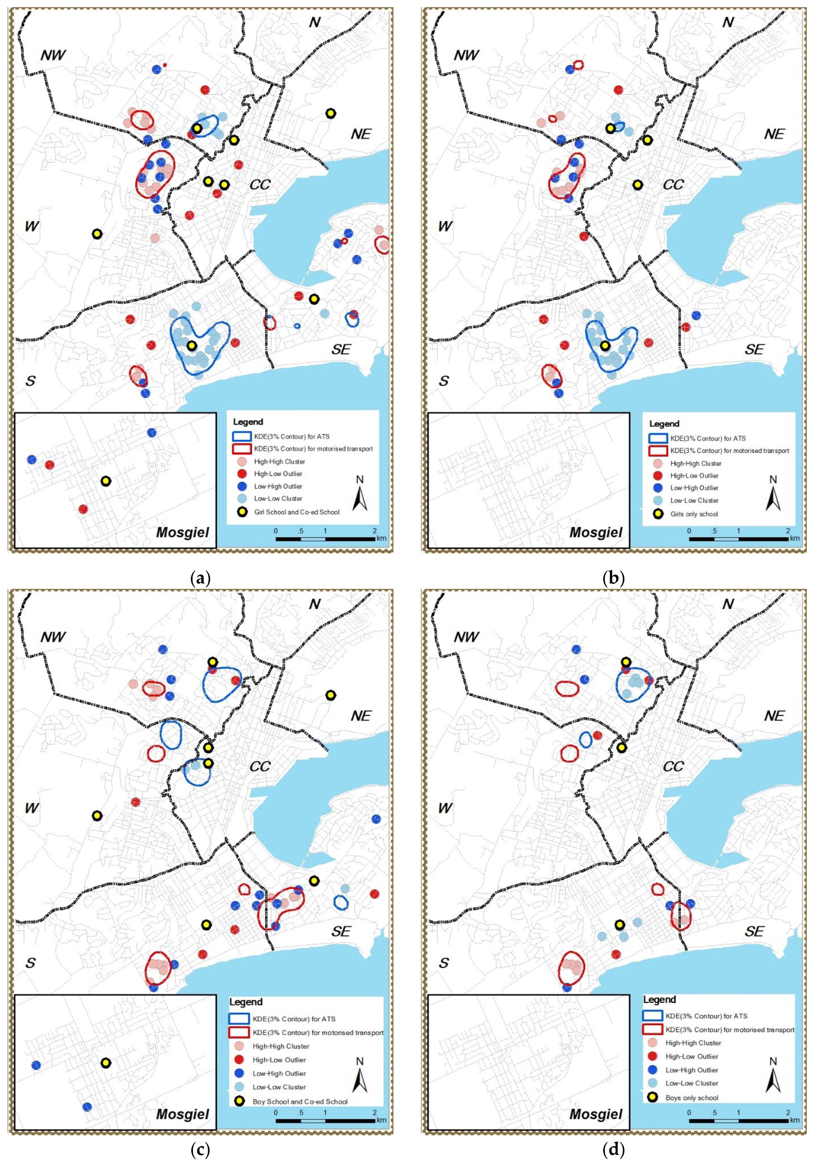
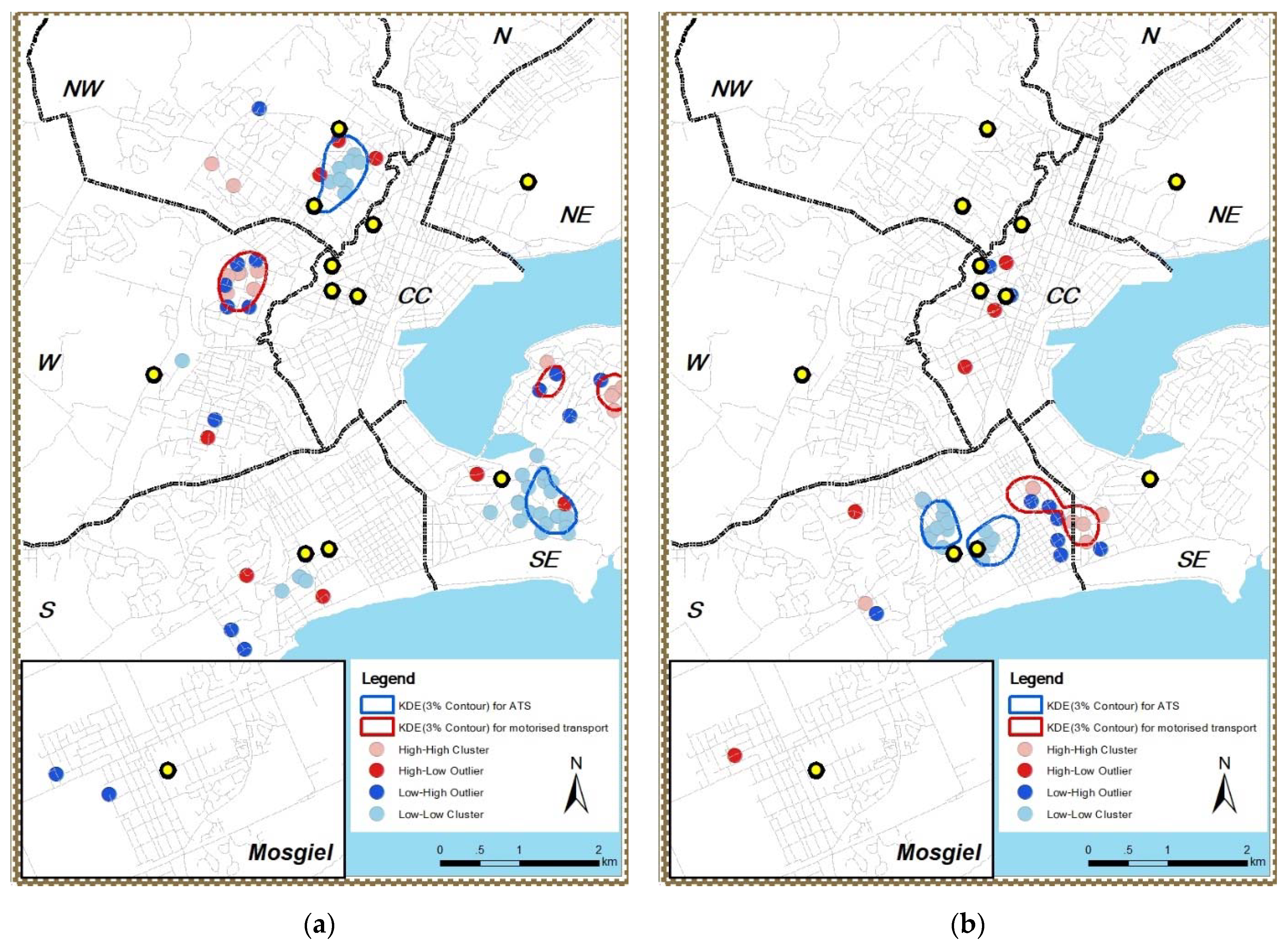
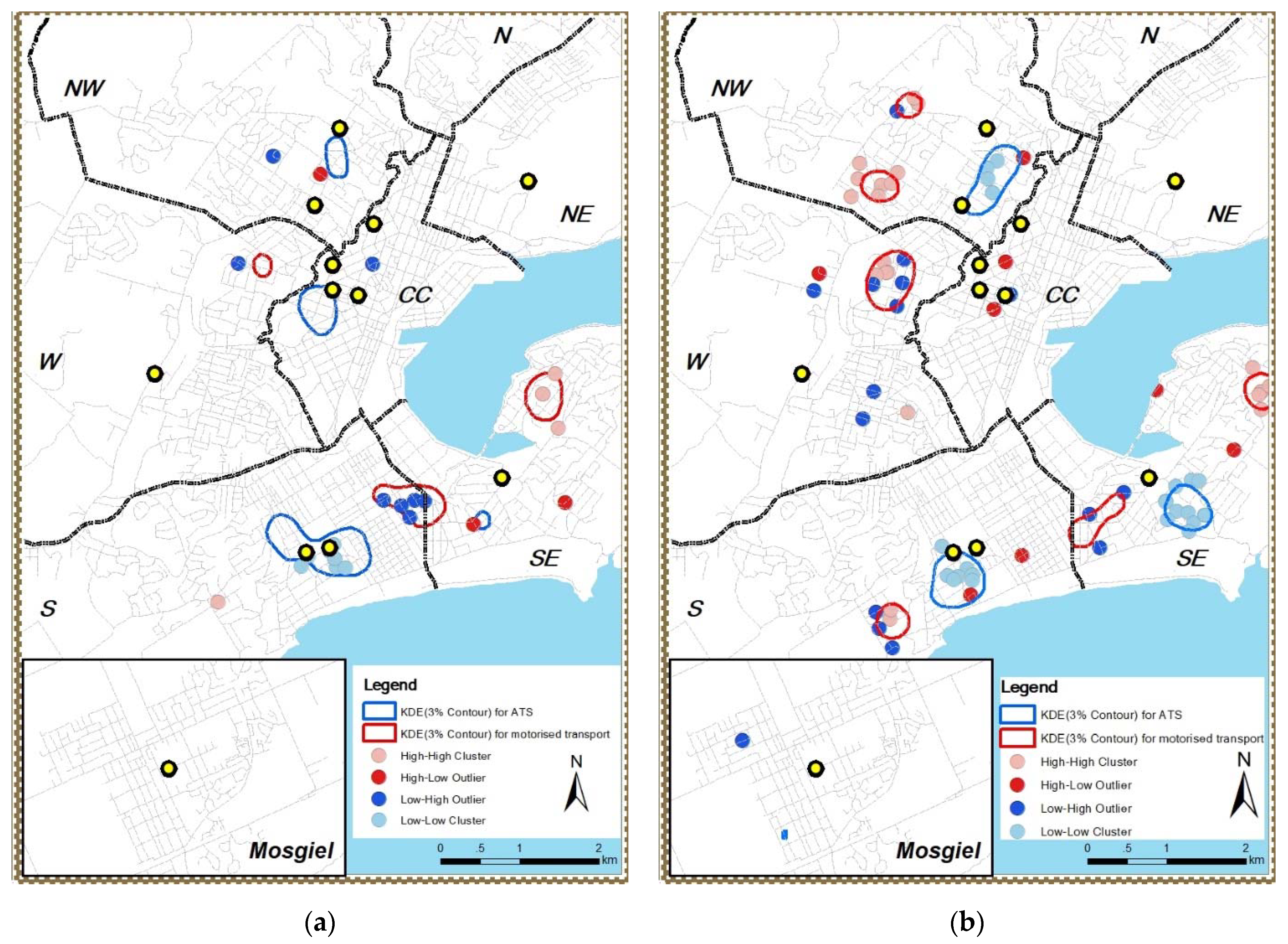
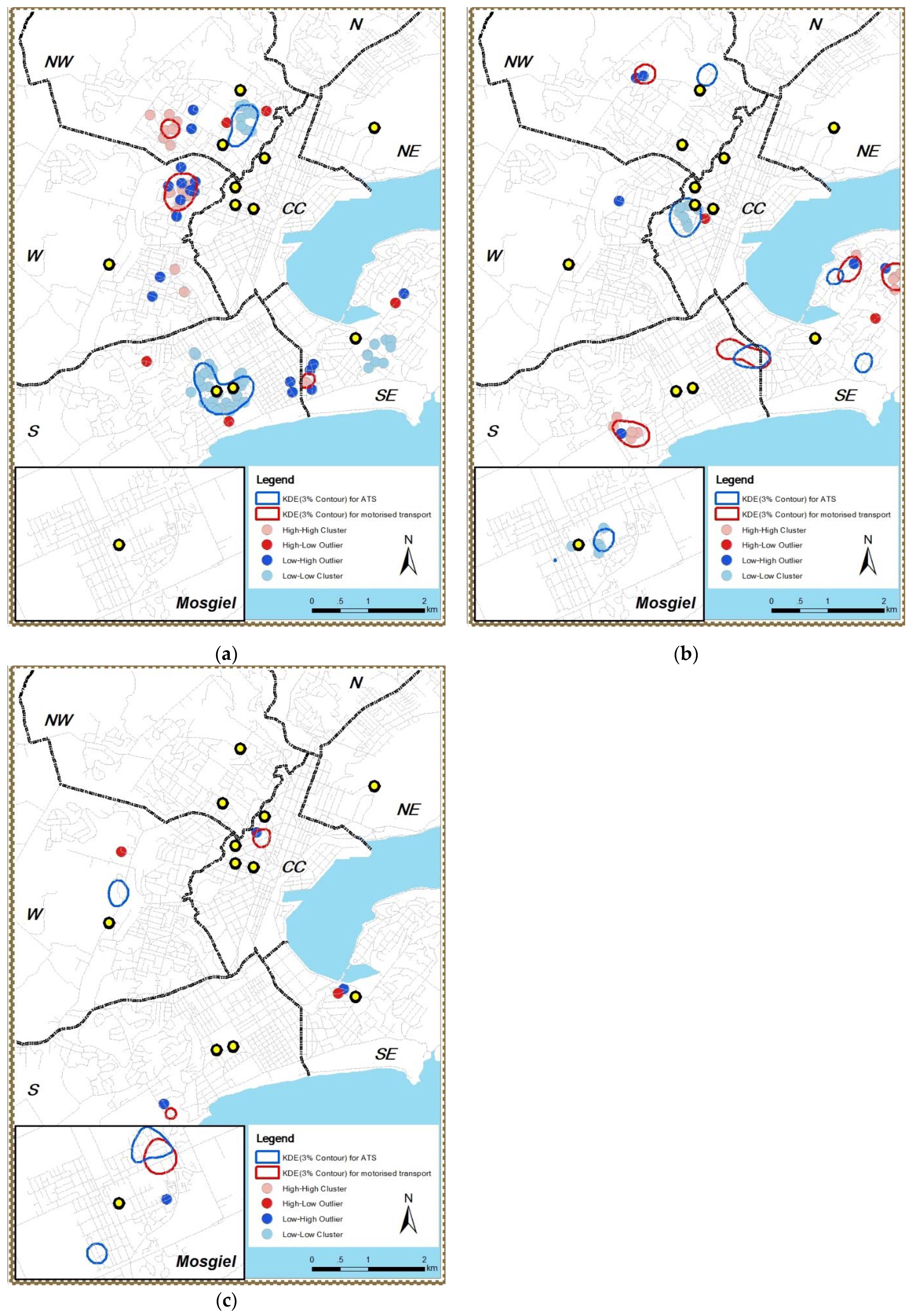
To foster logical and unambiguous mapping of the association between ATS and ATS factors over space, classification methods were applied on the ATS factor results:
(a) ATS factors, which have natural categories (e.g., gender: female/male) were grouped based on those categories. Home neighbourhood deprivation index was originally categorized into 5 levels with level 1 indicating low level deprived home neighbourhood and level 5 indicating highly deprived home neighbourhood. In terms of presenting significant spatial patterns of KDE and LISA for deprivation index difference and for better interpretation of the results, this study recoded home neighbourhood deprivation index 1 and 2 into less deprived home neighbourhood, index 3 into medium deprived home neighbourhood, and index 4 and 5 into more deprived home neighbourhood.
(b) ATS factors with unique numerical values for each individual adolescent home sample point including home neighbourhood residential density, intersection density, and mixed land use entropy were divided into 3 classes (low, medium, and high level) by Jenks Natural Breaks [45]. Jenks Natural Breaks classification was based on natural groupings implicit in the data. Class breaks were created in such a way as to group similar values for an ATS factor together whilst maximizing the differences between classes. Details of data grouping is shown in Table 1.

3. Results

This section presents the spatial analysis results from both KDE and LISA. In terms of better presenting the results of KDE and LISA, as indicated in the methods section, a 3% volume contour line was calculated from the KDE surface representing the location and area of high-density kernel patterns. The blue contour line represents the top 3% of a kernel pattern of ATS users in association with each individual ATS factor, while the red contour line represents MTS users. Clustered light blue points are low-low clusters from LISA, which indicate a cluster of ATS users in association with individual ATS factors, while light pink points are high-high clusters indicating a cluster of MTS users. Dark blue points represent an ATS user outlier among MTS clusters, while red points are MTS user outliers among ATS clusters. This study is trying to find the signs of the spatially varying distribution of KDE patterns and LISA clusters which are the evidence supporting the relationship between ATS and ATS factors as it varies over space.
There were large spatial overlaps between female ATS users (Figure 2a) and girls-only school attending ATS users (Figure 2b) in the south of the city. This particular result indicates not only that female ATS users and girls-only school attending ATS users lived close to each other, but potentially also attending girls-only school was connected to these female ATS users in the south of the city (i.e., a local, not global relationship of the kind this spatial study is trying to reveal). A similar spatial association was found with male ATS users (Figure 2c) and boys-only school attending ATS users (Figure 2d) in the northwest of the city. In terms of MTS usage, the distributions of female and girls-school attendees in the northwest, west, and south of the city were similar, while the distribution of male and boys-school attendees was also considered similar with the only exception located along the border dividing south and southeast zones of the city.
ATS rates varied across the city relative to neighbourhood deprivation. Less deprived neighbourhoods in the northwest of the city (Figure 3a) and more deprived neighbourhoods in the south of the city had higher ATS rates compared to MTS usage (Figure 3b). The evidence in the maps indicated that there was a spatially varying relationship between ATS usage and different deprivation level of the home neighbourhoods.
All adolescents with no vehicle at home used ATS from home to school (except one in Mosgiel using MTS). Adolescents with one vehicle at home used more ATS in the south and the city centre than those living in the southeast (Figure 4a). With two or more vehicles at home, there were both ATS and MTS users in the northwest, south, and southeast of the city (Figure 4b).
Figure 5 indicated that adolescents who live in the neighbourhoods with medium intersection density in the north and city centre area used more ATS (Figure 5b) than the rest of the city. On the contrary, in the south where there were homes in higher level intersection density areas, the ATS rate was higher (Figure 5c) in comparison with other city areas.
This study did not find any significant ATS user clusters within low residential density areas. Figure 6 shows that adolescents with medium residential density (Figure 6a) in the north and the southeast yielded more ATS clusters than the rest of the city, while adolescents in the south with high residential density (Figure 6b) also demonstrated a significantly higher ATS rate.
The KDE result indicated no significant association between ATS rate and the medium and high-level mixed land use entropy in the home neighbourhood. On the other hand, LISA analysis indicated clear clusters in the northwest and south of the city (Figure 7a) and city centre area (Figure 7b), which can be presented as evidence to support the association between ATS rate and mixed land use entropy.
Figure 8 summarises the distribution of both KDE and LISA spatial patterns. The summary includes the spatial pattern distributions in seven zones of the city and the medium urban area Mosgiel. Spatial patterns for both ATS and MTS were mainly observed in the southeast, south, west, and northwest of the city. There was no pattern observed in the north and northeast of the city. The spatial coincidence of distribution between the transport modes used and the distribution of the ATS factors across the city was also highlighted in Figure 8. For example, there were matching results between KDE and LISA in terms of male ATS users in the south (matching KDE results of ATS with LISA result of Low-Low cluster) while female ATS usages in the southeast.

4. Discussion

This study applied exploratory spatial analysis and visually identified spatial patterns and clusters for both ATS and ATS factors from the distribution maps that are indicative of the existence of the positive spatial autocorrelation among ATS users. This study visually found a negative association between ATS rate and home-to-school distance and a positive association between adolescents’ use of ATS and home neighbourhood residential density and intersection density in adolescents living in Dunedin, New Zealand. This study also found the existence of a spatial association between ATS and ATS factors, including gender, co-educational school status, neighbourhood deprivation, and vehicle ownership. The locations of the clusters of ATS users were consistent with locations of clusters in the ATS factors (gender, co-educational school status, neighbourhood deprivation, and vehicle ownership), even though the nature of the association (whether positive or negative) is unclear. The findings of this study are based on mapped distributions which previous studies did not include. The literature that this discussion section discussed and linked with are all global and non-spatial studies and, therefore, comparisons between the findings from this study with results of previous studies should be made with caution.
The exploratory spatial analysis found spatial evidence for males and females to use ATS in different locations in the city. Previous non-spatial findings reported either one of the genders to be more likely to use ATS [7,8,9] or no association between ATS and gender [9,10]. This spatial analysis study found evidence in maps to support the relationship between gender and ATS, with added insight into variation across space. The difference between this local spatial analysis study and previous global statistics in ATS studies is that previous studies assumed the study site as one large ATS user cluster while this study released that assumption and found multiple clusters of ATS users in different areas in one study site. In the case of ATS usage in association with gender, previous studies that reported no association might have potentially ignored the possibility of existing multiple ATS user clusters across the study site. Although the spatial patterns of gender co-associated with the spatial patterns of ATS, the findings related to gender and ATS rate were not quantified findings indicating which gender was more likely to use ATS than the other one. On the contrary, it is a finding indicating the existence of spatial differences of ATS users of both genders across different locations in light of the locations of the single-sex schools within 2.25 km from adolescents’ homes (see next paragraph).
This study gathered evidence that gender and co-educational school status had potential similarities as regards ATS behaviour. The distribution similarity between female ATS users and ATS users attending girls-only schools in the south and male ATS users and ATS users attending boys-only schools in the northwest led this study to consider the linkage between gender and co-educational school attending status. The spatial distribution of ATS users attending single-sex schools provided evidence supporting ATS is associated with co-educational school status across different areas of the city. However, the current analysis did not conclude whether the association between co-educational school status and ATS usage was positive or negative. Mandic et al. [46] studied the factors that affect adolescents’ and their parents’ decisions about school choice. Among Dunedin adolescents, co-educational status was reported as one of the most common reasons among students who attended a co-educational school [46]. The overlap of the spatial distribution between gender-based ATS users and co-educational school status-based ATS users indicated that the presence of single-sex schools showed a clear impact on ATS usage in different genders in Dunedin. The spatial analysis method used in this study added a potential connection between ATS users of both genders and the respective single-sex school attendance by introducing thematically matching spatial patterns to add to the findings of previous global studies [46]. Future research should evaluate this finding and quantify the impact from the presence of single-sex schools to ATS users in respective genders.
Within the walking home-to-school distance that this research focused on, no positive/negative association between home neighbourhood deprivation and ATS range was identified in terms of the entire city. However, with the spatial analysis method this study applied, differences were found among the patterns of ATS usage associated with home neighbourhood deprivation index in the northwest and the south of the city. The findings were partially consistent (findings in the south of the city) with previous non-spatial studies that showed a negative association between the home neighbourhood deprivation index and ATS rates [8,11,16,17,18], while inconsistent in the northwest of the city where the adolescents used more ATS within less deprived home neighbourhood. Therefore, future research should identify and quantify the spatial relationship between home neighbourhood deprivation and ATS across the areas that have been identified to be significant. For example, the negative association between ATS and home neighbourhood deprivation index in the south of the city that this study found need to be verified by spatial statistical modelling methods and then quantify the extent of the association. The verified and quantified results from future study could then be used to help to make suggestions to encourage ATS usage accordingly.
Having a vehicle or not was a defining factor affecting adolescents’ transport mode to school in this study. Within walkable distance, almost all adolescents with no vehicle at home used ATS. In addition, as vehicle ownership increased, the usage of MTS to school mode increased within walking distance. These findings are consistent with previous non-spatial studies where vehicle ownership was negatively correlated with ATS usage [10,11,12,47,48]. On the other hand, when adolescents lived in households with at least one vehicle and within walking distance to school, the relationship between vehicle ownership and the use of ATS varied across different areas of the city (the association was negative in the city centre while positive in the northwest and some area in southeast of the city). This finding is different from previous studies since this study presented the association between ATS usage and vehicle ownership in a spatial sense rather than a global (non-spatial) sense, which means more detailed spatial differences were observed. Future research could apply or improve the spatial analysis approach and focus on quantifying the localised spatial relationship between ATS and household vehicle ownership.
This study found that with increasing intersection density, ATS usage among Dunedin adolescents living within walking distance to their school increased. The ATS distribution associated with intersection density varied over the study city from the north to the south. Non-spatial findings from previous studies showed that higher intersection density means a better road network connection [12,23], which can encourage ATS usage [8,10] even though crossing the road was reported as a challenge for adolescents and hence was considered as a barrier of using ATS [12,21,22,23]. Future research should consider verifying the positive association between ATS usage and intersection density across the city that this study found with quantitative spatial statistical modelling.
This study found a positive relationship between home neighbourhood residential density and the ATS rate at a global scale across the city, which is consistent with previous non-spatial studies [8,10,25,26]. On a local scale, this study also found a detailed spatial difference in the relationship between residential density in the home neighbourhood and ATS usage across space (the density level of ATS users in the south was higher than the northwest and the city centre of the city). However, the information that this study presented is from a spatial and localised aspect. As this study was only a qualitative spatial analysis, future research should consider confirming the results of this study and quantifying the spatial relationship between ATS and residential density across the city.
A high level of mixed land use entropy (more heterogeneous land use types) was not associated with a higher rate of ATS in Dunedin adolescents, despite higher mixed land use being positively associated with ATS in previous non-spatial studies [10]. The reason for the non-significant relationship between mixed land use entropy and ATS rate in this study might be the low mixed land use entropy levels across predominantly evenly distributed residential areas of the study city (except the city centre area, which has little residential land use). As mentioned in the results section, by unearthing significant clustering, LISA disagreed with KDE in terms of the association between mixed land use entropy and ATS rate in a local spatial analysis sense, indicating an association between ATS rates and mixed land use entropy. However, the controversial result means this exploratory spatial analysis study cannot confirm the association between ATS rate and mixed land use entropy which means that future research should further evaluate the results of this study and make a final suggestion of the relationship between ATS and mixed land use entropy. Future research should also make a comparison between different, more varied study sites to further and more robustly evaluate the spatial association between mixed land use entropy and ATS usage. To be specific, the study site for future study should be in larger cities where land use diversity level would be much higher than the city that this study focused on or across different urbanization settings.
Maps generated as part of this cross-sectional research indicated the spatial distribution of ATS users across different categories of ATS factors. However, cross-sectional design prevents making conclusions about causality. The maps could be considered as reference material for decision makers in the city council and local schools to have an initial idea of where and which ATS factors, including the examined built environment factors, were associated (positively or negatively) with ATS usage among Dunedin adolescents. Hence, decision makers could use the map evidence to generate initial ideas about what further investigations (e.g., quantitative association and causation between ATS and ATS factors) could be instigated, along with information on priority. For example, residential density was positively associated with ATS usage in the south of the city, with locations reported in the map. Therefore, with further investigation into quantitative association and causation, the possible increase of ATS could be factored into any planning decisions on the potential increase of residential density in specific parts of the city, which has been linked to a reduction in vehicle dependency and better access to schools [49]. In the case of the positive relationship of ATS with intersection density, with further evaluation, decision makers could likewise factor in potential ATS benefits when making decisions on increasing neighbourhood connectivity, and/or improving the safety and incidence of pedestrian crossings in such crucial areas of the city. A third example arising from evidence for decision-making from this study, potentially augmented with more robust evidence from follow-on study, is the targeting of less deprived areas of the city for ATS-boosting initiatives, given the mapped evidence that such areas favoured MTS when compared to more-deprived areas. Having said this, the reference material that the mapped results provided were not processed to a quantitative level. Therefore, to follow up, confirmation of the quantitative relationship between ATS usage and ATS factors through a spatial modelling approach could be applied in the future.
The strengths of this study include a geographic approach to examine the spatial relationship between ATS and ATS factors using spatial analysis. Instead of statistical analysis, this study provided a direct and visible way to zoom in from the global view to a localised view. This localised view spatially indicated that the relationship between ATS and ATS factors in one part of the city may not be the same as in another part of the city. These spatial differences varying across the city (instances of spatial non-stationarity) visually identified in this study are providing a guideline for future quantitative spatial analysis, and a geographically weighted regression (GWR) [50] modelling is recommended for further studies. Previous studies used global (non-spatial) analysis methods that suggested the association between ATS and ATS factors as a whole picture and omitted the spatial difference between locations of the study area [47,51]. One of the purposes of applying the spatial analysis method to human activities is to provide evidence supporting decision making. Although this study was not a quantitative spatial statistical analysis, the findings of this study, along with potential future quantitative spatial statistical analysis, could support decision making of the local government and schools. Future studies should quantify the association between ATS and ATS factors that this study examined and confirm and further evaluate the difference of the association across space in the study site. The findings of quantitative spatial statistical analysis will confirm the association between ATS and ATS factors that this study identified across the city and suggest how ATS rates would change along with the change of the corresponding ATS factors. With further quantified evaluation and confirmation, planning decisions such as whether to increase intersection density and/or residential density in the home neighbourhoods could be made based on the maps of this study and future studies to consider locations of improvement to encourage the ATS usage.
However (and this is a limitation of the study), due to the fact that the hotspot maps (KDE maps) lend themselves to qualitative assessment only, the maps should be used as decision support documents with caution. Insights are gained through a visualised detection method based on human judgement and recognition of spatial patterns. Therefore, bias and subjective identifications could infiltrate the analysis. Secondly, the findings of this study did not imply any causation between ATS and examined ATS factors, therefore, in interpreting the findings of this study, we should be careful not to imply causal relationships between ATS usage and ATS factors. The ATS factors detected in this study should nevertheless be further evaluated for their causality with the ATS rate in future studies. Thirdly, topography was not included as a factor in this study which was indicated in previous non-spatial studies to play a significant role in adolescents’ decisions on whether to use ATS or not [52]. As the study site was a hilly city, topography could play a significant role in influencing adolescents’ decisions about how they travel from home to school [52], therefore warranting closer investigation. Other than the exclusion of topography, the inclusion of ATS factors this study focused on was selective. Some objective factors, such as weather and school choice decisions, and subjective factors such as safety concerns and adolescents’ and their parents’ perspectives of ATS, were not included in this study, although previous studies [11,27,53] showed their relationship to ATS in adolescents. Other potential factors such as the width of streets, public transport services, sibling accompanies were also omitted from this study due to data availability. Thirdly, this study only focused on a large urban area (Dunedin city) along with a medium urban area (Mosgiel). The findings of this study may not be generalisable to urban centres, medium and small urban areas, or rural settlements. In addition, there was no ATS study conducted in other major cities in New Zealand. Future studies could make a comparison between major cities in the country and further examine the similarities and differences of association between ATS and ATS factors across New Zealand. City-level comparison could also be made across countries. Lastly, since the conducting of the BEATS study [6], a cycle lane infrastructure construction programme was introduced in Dunedin city. Although the cycle lanes were not directly designed to promote ATS for adolescents, it would still be valuable for future studies to evaluate the potential change of ATS usage (especially cycling to school) in Dunedin city.

5. Conclusions

In conclusion, using exploratory spatial analysis, this study confirmed negative spatial association among Dunedin adolescents between ATS rates and home to school distance. This study also confirmed clustering and, therefore, spatial autocorrelation among adolescents with respect to gender, co-educational school status, neighbourhood deprivation, family vehicle ownership, and home neighbourhood intersection, and residential density. The matching distribution between spatial patterns of the ATS factors and the ATS users that this study detected provided further evidence supporting the existence of spatial autocorrelation phenomenon underpinned ATS users across the study area. This study provided visible reference material for decision makers in the city council and local schools. With the maps that this study created, decision makers could have an initial idea of the specific location of where and how ATS usage is associated with ATS factors. This study provided evidence of varying spatial relationship between ATS and ATS factors for a future quantitative study to relay on, especially to support the inclusion of ATS factors in a geographically weighted regression model. Future studies should use such quantitative spatial analysis methods to further evaluate and confirm the relationship between ATS and ATS factors across the study area.

Author Contributions

Conceptualization Long Chen, Antoni B. Moore and Sandra Mandic; methodology, Long Chen; formal analysis, Long Chen; data curation, Long Chen and Sandra Mandic; writing—original draft preparation, Long Chen; writing—review and editing, Antoni B. Moore and Sandra Mandic; super-vision, Antoni B. Moore and Sandra Mandic; funding acquisition, Sandra Mandic. All authors have read and agreed to the published version of the manuscript.

Funding

This work was supported by the Health Research Council of New Zealand Emerging Researcher First Grant (14/565), National Heart Foundation of New Zealand (1602 and 1615), Lottery Health Research Grant (Applic 341129), University of Otago Research Grant (UORG 2014), and Dunedin City Council. L.C. was supported by a PhD scholarship from Health Research Council of New Zealand grant for the BEATS Natural Experiment (19/173).

Institutional Review Board Statement

The study was conducted according to the guidelines of the Declaration of Helsinki, and approved by the University of Otago Human Ethics Committee (reference number: 13/203; 19 July 2013).

Informed Consent Statement

All adolescent participants signed written consent to participate in this study. For adolescents under the age of 16 years, parental opt-in or parental opt-out consent was used based on school’s preference.

Data Availability Statement

Data used in data analysis for this project will not be shared due to sensitivity of the collected data as well as participants having been given assurances that the collected data will not be shared.

Acknowledgments

This research is a part of the BEATS Research Programme which is a collaboration between the Dunedin Secondary Schools’ Partnership, Dunedin City Council, University of Otago and Auckland University of Technology. The authors would like to acknowledge the BEATS investigators, Advisory Board members, collaborators, research personnel (research assistants, research students and volunteers), and all the participating schools and students.

Conflicts of Interest

The authors declare no conflict of interest.

References

  1. Mindell, J.S.; Mandic, S. Transport Modes and Health. In International Encyclopedia of Transportation; Vickerman, R., Ed.; Elsevier Ltd.: London, UK, 2021; Volume 5, pp. 106–117. [Google Scholar]
  2. Khan, A.; Mandic, S.; Uddin, R. Association of active school commuting with physical activity and sedentary behaviour among adolescents: A global perspective from 80 countries. J. Sci. Med. Sport 2020, 24, 567–572. [Google Scholar] [CrossRef]
  3. Kek, C.C.; García Bengoechea, E.; Spence, J.; Mandic, S. The relationship between transport-to-school habits and physical activity in a sample of New Zealand adolescents. J. Sport Health Sci. 2019, 8, 463–470. [Google Scholar] [CrossRef] [PubMed]
  4. White, B.; García Bengoechea, E.; Spence, J.C.; Coppell, K.J.; Mandic, S. Comparison of physical activity patterns across large, medium, and small urban areas and rural settings in the Otago Region, New Zealand. N. Z. Med. J. 2021, 134, 51–56. [Google Scholar]
  5. Cooper, A.R.; Wedderkopp, N.; Wang, H.; Andersen, L.B.; Froberg, K.; Page, A.S. Active travel to school and cardiovascular fitness in Danish children and adolescents. Med. Sci. Sports Exerc. 2006, 38, 1724–1731. [Google Scholar] [CrossRef]
  6. Mandic, S.; Williams, J.; Moore, A.; Hopkins, D.; Flaherty, C.; Wilson, G.; García Bengoechea, E.; Spence, J.C. Built Environment and Active Transport to School (BEATS) Study: Protocol for a cross-sectional study. BMJ Open 2016, 6, e011196. [Google Scholar] [CrossRef] [PubMed] [Green Version]
  7. Larsen, K.; Gilliland, J.; Hess, P.M. Route-Based Analysis to Capture the Environmental Influences on a Child’s Mode of Travel between Home and School. Ann. Assoc. Am. Geogr. 2012, 102, 1348–1365. [Google Scholar] [CrossRef]
  8. Ikeda, E.; Stewart, T.; Garrett, N.; Egli, V.; Mandic, S.; Hosking, J.; Witten, K.; Hawley, G.; Tautolo, E.S.; Rodda, J.; et al. Built environment associates of active school travel in New Zealand children and youth: A systematic meta-analysis using individual participant data. J. Transp. Health 2018, 9, 117–131. [Google Scholar] [CrossRef]
  9. Uddin, R.; Mandic, S.; Khan, A. Active commuting to and from school among 106,605 adolescents in 27 Asia-Pacific countries. J. Transp. Health 2019, 15, 100637. [Google Scholar] [CrossRef]
  10. Kerr, J.; Frank, L.; Sallis, J.; Chapman, J. Urban form correlates of pedestrian travel in youth: Differences by gender, race-ethnicity and household attributes. Transp. Res. Part D Transp. Environ. 2007, 12, 177–182. [Google Scholar] [CrossRef]
  11. Mandic, S.; De La Barra, S.L.; Bengoechea, E.G.; Stevens, E.; Flaherty, C.; Moore, A.; Middlemiss, M.; Williams, J.; Skidmore, P. Personal, social and environmental correlates of active transport to school among adolescents in Otago, New Zealand. J. Sci. Med. Sport 2015, 18, 432–437. [Google Scholar] [CrossRef]
  12. Guliani, A.; Mitra, R.; Buliung, R.N.; Larsen, K.; Faulkner, G.E.J. Gender-based differences in school travel mode choice behavior: Examining the relationship between the neighbourhood environment and perceived traffic safety. J. Transp. Health 2015, 2, 502–511. [Google Scholar] [CrossRef]
  13. Easton, S.; Ferrari, E. Children’s travel to school—The interaction of individual, neighbourhood and school factors. Transp. Policy 2015, 44, 9–18. [Google Scholar] [CrossRef] [Green Version]
  14. Mackett, R.L. Children’s travel behaviour and its health implications. Transp. Policy 2013, 26, 66–72. [Google Scholar] [CrossRef] [Green Version]
  15. Wong, B.Y.; Faulkner, G.; Buliung, R. GIS measured environmental correlates of active school transport: A systematic review of 14 studies. Int. J. Behav. Nutr. Phys. Act. 2011, 8, 39. [Google Scholar] [CrossRef] [Green Version]
  16. Martin, S.; Lee, S.; Lowry, R. National prevalence and correlates of walking and bicycling to school. Am. J. Prev. Med. 2007, 33, 98–105. [Google Scholar] [CrossRef]
  17. McDonald, N. Critical factors for active transportation to school among low- income and minority students: Evidence from the 2001 national household travel survey. Am. J. Prev. Med. 2008, 34, 341–344. [Google Scholar] [CrossRef]
  18. McMillan, T.E. Urban form and a child’s trip to school: The current literature and a framework for future research. J. Plan. Lit. 2005, 19, 440–456. [Google Scholar] [CrossRef]
  19. Cutumisu, N.; Belanger-Gravel, A.; Laferte, M.; Lagarde, F.; Lemay, J.F.; Gauvin, L. Influence of area deprivation and perceived neighbourhood safety on active transport to school among urban Quebec preadolescents. Can. J. Public Health 2014, 105, e376–e382. [Google Scholar] [CrossRef]
  20. Hatamzadeh, Y.; Habibian, M.; Khodaii, A. Walking behaviour across genders in school trips, a case study of Rasht, Iran. J. Transp. Health 2017, 5, 24–54. [Google Scholar] [CrossRef]
  21. Race, D.L.; Sims-Gould, J.; Lee, N.C.; Frazer, A.D.; Voss, C.; Naylor, P.J.; Mckay, H.A. Urban and suburban children’s experiences with school travel—A case study. J. Transp. Health 2017, 4, 305–315. [Google Scholar] [CrossRef]
  22. Davison, K.K.; Werder, J.L.; Lawson, C.T. Children’s active commuting to school: Current knowledge and future directions. Prev. Chronic Dis. 2008, 5, A100. [Google Scholar] [PubMed]
  23. Scheiner, J.; Huber, O.; Lohmϋller, S. Children’s independent travel to and from primary school: Evidence from a suburban town in Germany. Transp. Res. Part A 2019, 120, 116–131. [Google Scholar] [CrossRef]
  24. Rothman, L.; Buliung, R.; To, T.; Macarthur, C.; Macpherson, A.; Howard, A. Associations between parents’ perception of traffic danger, the built environment and walking to school. J. Transp. Health 2015, 2, 327–335. [Google Scholar] [CrossRef]
  25. Nelson, N.; Foley, E.; O’Gorman, D.; Moyna, N.; Woods, C. Active commuting to school: How far is too far? Int. J. Behav. Nutr. Phys. Act. 2008, 5, 1–9. [Google Scholar] [CrossRef] [Green Version]
  26. Pont, K.; Ziviani, J.; Wadley, D.; Bennett, S.; Abbott, R. Environmental correlates of children’s active transportation: A systematic literature review. Health Place 2009, 15, 849–862. [Google Scholar] [CrossRef] [PubMed]
  27. Helbich, M.; van Emmichoven, M.J.Z.; Dijst, M.J.; Kwan, M.P.; Pierik, F.H.; de Vries, S.I. Natural and built environmental exposures on children’s active school travel: A Dutch global positioning system-based cross-sectional study. Health Place 2016, 39, 101–109. [Google Scholar] [CrossRef]
  28. Longley, P.; Goodchild, M.; Maguire, D.; Rhind, D. Geographical Information Science and Systems, 4th ed.; Wiley: Hoboken, NJ, USA, 2015; ISBN 9781118676950. [Google Scholar]
  29. Tobler, W.R. A computer movie simulating urban growth in the Detroit region. Econ. Geogr. 1970, 46, 234–240. [Google Scholar] [CrossRef]
  30. O’Sullivan, D.; Unwin, D.J. Geographic Information Analysis, 2nd ed.; John Wiley & Sons: Hoboken, NJ, USA, 2010. [Google Scholar]
  31. Silverman, B.W. Density Estimation for Statistics and Data Analysis; Chapman Hall: London, UK, 1986. [Google Scholar]
  32. Anselin, L. Local Indicators of Spatial Association—LISA. Geogr. Anal. 1995, 27, 93–115. [Google Scholar] [CrossRef]
  33. Yuan, Y.; Cave, M.; Zhang, C.S. Using Local Moran’s I to identify contamination hotspots of rare earth elements in urban soils of London. Appl. Geochem. 2017, 88, 167–178. [Google Scholar] [CrossRef]
  34. Ruiz, A.R.; Pascual, U.; Romero, M. An exploratory spatial analysis of illegal coca cultivation in Colombia using local indicators of spatial association and socioecological variables. Ecol. Indic. 2013, 34, 103–112. [Google Scholar] [CrossRef]
  35. Wahiduzzaman, M.; Yeasmin, A. A kernel density estimation approach of North Indian Ocean tropical cyclone formation and the association with convective available potential energy and equivalent potential temperature. Meteorol. Atmos. Phys. 2020, 132, 603–612. [Google Scholar] [CrossRef]
  36. Maheswaran, R.; Haining, R.P. Basic Issues in Geographicall Analysis. In GIS Application in Public Health Practice, 1st ed.; Maheswaran, R., Craglia, M., Eds.; CRC Press: Washington, DC, USA, 2004; pp. 21–24. [Google Scholar]
  37. Spencer, J.; Angeles, G. Kernel density estimation as a technique for assessing availability of health services in Nicaragua. Health Serv. Outcomes Res. Method 2007, 7, 145–157. [Google Scholar] [CrossRef]
  38. Pouliou, T.; Elliott, S.J. An exploratory spatial analysis of overweight and obesity in Canada. Prev. Med. 2009, 48, 362–367. [Google Scholar] [CrossRef]
  39. Pocock, T.; Moore, A.; Keall, M.; Mandic, S. Physical and spatial assessment of school neighbourhood built environments for active transport to school in adolescents from Dunedin (New Zealand). Health Place 2019, 55, 1–8. [Google Scholar] [CrossRef] [PubMed]
  40. Mandic, S.; Flaherty, C.; Pocock, T.; Mintoft-Jones, A.; Frater, J.; Chillón, P.; García Bengoechea, E. Attitudes towards cycling skills training in New Zealand adolescents. Transp. Res. Part F Traffic Psychol. Behav. 2016, 42, 217–226. [Google Scholar] [CrossRef]
  41. Mandic, S.; Flaherty, C.; Ergler, C.; Kek, C.C.; Pocock, T.; Lawrie, D.; Chillón, P.; García Bengoechea, E. Effects of cycle skills training on cycling-related knowledge, confidence and behaviour in adolescent girls. J. Transp. Health 2018, 9, 253–263. [Google Scholar] [CrossRef]
  42. Cervero, R.; Kockelman, K. Travel demand and the 3Ds: Density, diversity, and design. Transp. Res. Part D Transp. Environ. 1997, 2, 199–219. [Google Scholar] [CrossRef]
  43. Salmond, C.E.; Crampton, P. Development of New Zealand’s Deprivation Index (NZDep) and Its Uptake as a National Policy Tool. Can. J. Public Health 2012, 103, s7–s11. [Google Scholar] [PubMed]
  44. Crampton, P.; Salmond, C.; Atkinson, J. A comparison of the NZDep and New Zealand IMD indexes of socioeconomic deprivation. Kōtuitui N. Z. J. Soc. Sci. Online 2020, 15, 154–169. [Google Scholar] [CrossRef]
  45. Jenks, G.F. The Data Model Concept in Statistical Mapping. Int. Yearb. Veh. 1967, 7, 186–190. [Google Scholar]
  46. Mandic, S.; Sandretto, S.; Hopkins, D.; Wilson, G.; Moore, A.; García Bengoechea, E. “I wanted to go here”: Adolescents perspectives on school choice. J. Sch. Choice Int. Res. Reform 2018, 12, 98–122. [Google Scholar] [CrossRef]
  47. Merom, D.; Tudor-Locke, C.; Bauman, A.; Rissel, C. Active commuting to school among NSW primary school children: Implications for public health. Health Place 2006, 12, 678–687. [Google Scholar] [CrossRef] [PubMed]
  48. Alton, D.; Adab, P.; Roberts, L.; Barrett, T. Relationship between walking levels and perceptions of the local neighbourhood environment. Arch. Dis. Child. 2007, 92, 29–33. [Google Scholar] [CrossRef] [PubMed] [Green Version]
  49. Haarhoff, E.; Beattie, L.; Dupuis, A. Does higher density housing enhance liveability? Case studies of housing intensification in Auckland. Cogent Soc. Sci. 2016, 2, 1243289. [Google Scholar] [CrossRef]
  50. Fotheringham, A.S.; Brunsdon, C.; Charlton, M. Geographically Weighted Regression: The Analysis of Spatially Varying Relationships; John Wiley & Sons: West Sussex, UK, 2002. [Google Scholar]
  51. Richard, L.; Chaput, J.P.; Leduc, G.; Boyer, C.; Belanger, P.; LeBlanc, A.G.; Borghese, M.M.; Tremblay, M.S. A cross-sectional examination of socio-demographic and school-level correlates of children’s school travel mode in Ottawa, Canada. BMC Public Health 2014, 14, 497. [Google Scholar] [CrossRef] [Green Version]
  52. Timperio, A.; Ball, K.; Salmon, J.; Roberts, R.; Giles-Corti, B.; Simmons, D.; Baur, L.; Crawford, D. Personal, family, social, and environmental correlates of active commuting to school. Am. J. Prev. Med. 2006, 30, 45–51. [Google Scholar] [CrossRef]
  53. Mandic, S.; Hopkins, D.; García Bengoechea, E.; Flaherty, C.; Coppell, K.; Moore, A.; Williams, J.; Spence, J.C. Differences in Parental Perceptions of Walking and Cycling to High School According to Distance. Transp. Res. Part F Traffic Psychol. Behav. 2020, 71, 238–249. [Google Scholar] [CrossRef]
Figure 1. City areas with important streets, suburbs, districts, and 12 high schools in Dunedin City.
Ijgi 10 00495 g001
Figure 2. KDE and LISA transport modes distribution on gender and co-educational school attending status: (a) female; (b) male; (c) girls-only school attenders; (d) boys-only school attenders.
Ijgi 10 00495 g002
Figure 3. KDE and LISA transport modes distribution on home deprivation index: (a) less deprived home neighbourhood; (b) more deprived home neighbourhood.
Ijgi 10 00495 g003
Figure 4. KDE and LISA transport modes distribution on vehicle ownership per household: (a) one vehicle per household; (b) two or more vehicles per household.
Ijgi 10 00495 g004
Figure 5. KDE and LISA transport modes distribution on intersection density: (a) low home neighbourhood intersection density; (b) medium home neighbourhood intersection density; (c) high home neighbourhood intersection density.
Ijgi 10 00495 g005
Figure 6. KDE and LISA transport modes distribution on residential density: (a) medium home neighbourhood residential section density; (b) high home neighbourhood residential density.
Ijgi 10 00495 g006
Figure 7. KDE and LISA transport modes distribution on mixed land use entropy: (a) low home neighbourhood mixed land use entropy; (b) medium home neighbourhood mixed land use entropy; (c) high home neighbourhood mixed land use entropy.
Ijgi 10 00495 g007
Figure 8. Summary of the KDE and LISA pattern distribution of individual ATS factor groups over eight zones within the study site.
Ijgi 10 00495 g008
Table 1. Classes of ATS factors.
FactorStatistical SummaryCategoriesParticipants [n (%)]
Gender Male
Female
189
236
(44.47%)
(55.53%)
DeprivationRange: 1–5
Mean: 2.621
STD: 1.346
Less
Medium
More
205
96
124
(48.24%)
(22.57%)
(29.18%)
Vehicle ownership per householdRange: 0–4
Mean: 1.774
STD: 0.923
None
1
2 or more
19
162
244
(4.47%)
(38.12%)
(57.41%)
Co-educational school attendance Co-ed school
Girls’ school
Boys’ school
198
122
105
(46.59%)
(28.71%)
(24.71%)
Transport modes ATS
MTS
293
132
(68.94%)
(31.06%)
Intersection density (/km2)Range: 6.66–125.929
Mean: 26.229
STD: 21.373
Low (<=33.85)
Medium (33.86–67.03)
High (>67.03)
55
266
104
(12.94%)
(62.59%)
(24.47%)
Residential density (/km2)Range: 33.299–1719.202
Mean: 1049.787
STD: 251.298
Low (<=554.58)
Medium (554.59–1041.21)
High (>1041.21)
6
225
194
(1.41%)
(52.94%)
(45.65%)
Mixed land use entropyRange: 0.033–0.618
Mean: 0.217
STD: 0.119
Low (0–0.18)
Medium (0.19–0.37)
High (0.38–1)
203
174
48
(47.76%)
(40.94%)
(11.29%)
Publisher’s Note: MDPI stays neutral with regard to jurisdictional claims in published maps and institutional affiliations.

