
A Survey of Scan-to-BIM Practices in the AEC Industry—A Quantitative Analysis


CIAUD, Faculdade de Arquitetura, Universidade de Lisboa, 1349-063 Lisbon, Portugal
*
Author to whom correspondence should be addressed.
ISPRS Int. J. Geo-Inf. 2021, 10(8), 564; https://0-doi-org.brum.beds.ac.uk/10.3390/ijgi10080564
Submission received: 20 June 2021
/
Revised: 5 August 2021
/
Accepted: 15 August 2021
/
Published: 19 August 2021
(This article belongs to the Special Issue Multi-Resolution Data Fusion for Heritage Building Information Modeling (HBIM) and CityGML Organization)
Abstract
:Architectural survey methods using terrestrial 3D laser scanning and digital photogrammetry prove capable of registering a building with a level of accuracy far superior to traditional methods, minimizing errors, and reducing fieldwork. Current developments in the construction industry, and new requirements emerging worldwide, have increased the demand for building information modeling (BIM) models as the end product of these surveys. Still, because BIM is a new paradigm, many professionals find the transition challenging, especially when dealing with old and heritage buildings. The new ways of the market demand solutions to optimize processes and make architectural reconstruction from point clouds even more efficient. An online questionnaire survey was carried out with 208 industry professionals working in 78 countries to assess the scope of these demands. As a result, the article presents an overview of current scan-to-BIM practices worldwide with data regarding the architectural survey and BIM modeling derived from point clouds. The implemented survey also identifies in which countries BIM adherence is most accelerated for conventional buildings and for listed buildings and non-listed old buildings, the main benefits and difficulties encountered by professionals, tools and workflows used, and the role of different professionals in collaborative work.
1. Introduction
Throughout history, together with architectural survey techniques, approaches to representing the building and its elements in three-dimensional reproductions have been created to better understand spatiality, proportions, geometry, and construction techniques employed [1]. The architectural survey, being one of the first steps carried out within a preexisting building workflow, is fundamental to the proper functioning of the next steps of the process, and the graphic documentation generated from it is vital for the analysis and planning of actions to be carried out on a built architectural object [1,2].
With the emergence of building information modeling (BIM), which allows construction to be managed in its total life cycle, from design and construction to maintenance and post-use management [3,4,5,6], there was also a demand for BIM models of preexisting buildings, which has led survey companies to seek to adapt to the new market reality. Nowadays, due to government incentives and industry requirements, the use of BIM is on the rise, but still with a significant predominance of new buildings [7,8]. Even in these cases, there is still resistance on the part of professionals to incorporate this new work methodology to their offices. Some factors contribute to hindering the complete transition from previous methodologies to BIM, such as the need for better interpolation and exchange of information between the various tools, the need for organization and standardization of work methods, the existence of contracts and traditional work agreements that make change difficult, and the high initial cost that a complete transition can bring to companies [9,10].
It is common to have technical plans of existing buildings in manual drawings, or even plans digitized in computer-aided design (CAD) files, but this is not the case for the existence of a BIM model or even a three-dimensional (3D) model of these buildings [11]. For these cases, it is necessary to carry out a reverse engineering process with architectural survey techniques to obtain the actual constructive conditions of the building and enable the construction of the BIM model of the existing building. Survey techniques with 3D laser scanner and photogrammetry play an important role in this process as they make it possible to perform the survey stage much faster than with traditional manual techniques. In addition, it enables the acquisition of more information and details and to capture with high precision and complex geometries [12,13,14,15]. Although the survey step, most of the time, is faster and easier to perform when compared to traditional techniques, it is common for some setbacks to arise in the BIM modeling process of the buildings surveyed, which, in some cases, makes converting the building into a BIM model a laborious and time-consuming step. Some factors interfere with the speed and ease with which these models will be created, such as the complexity and size of the building, the existence or not of secondary building elements such as windows, doors, construction details in BIM libraries of suppliers or private offices, the existing elements in the building that can be repeated or adapted from parametric models, and the final quality of the point cloud. It is important to master some basic BIM concepts to ensure a BIM model that suits the customer’s requirements, which is faithful to the constructed object and avoids consuming excessive time in its digital reconstruction; those concepts are the level of development (LOD) [16,17,18], level of accuracy (LOA) [17], BIM standards [18,19], and precision and tolerance [17,20].
The incorporation and application of BIM in historic buildings can bring significant benefits to the process. It is essential to recover the ability to master the complexity of shapes in their spatiality in the past, and HBIM can have a crucial supporting role in connecting geometry to its constructive reasoning and the behavior of an element within the entire system [1]. However, as they are buildings with complex structures and unconventional shapes, and in some cases, there is a need for greater accuracy and less tolerance to deviations than a standard model [21,22]. The lack of auxiliary data about the building and its construction method, the need for customized modeling of building elements that are not repeated elsewhere, and the lack of linearity and repetition in these cases make the digital reconstruction of heritage buildings a challenging task. For those reasons, it may require more time and effort than with conventional buildings, especially if there is a need to create a BIM model for it [23,24,25]. These factors, which make the process slower and more expensive, can affect the choice of the type of methodology to be used in these projects, whether they use BIM or the traditional methodology.
BIM and scan-to-BIM are concepts that are extensively investigated both in their basic definitions and in their subtopics. There are some good examples of research that addressed some of the themes that involve this universe. Some authors research the BIM Execution Plan (BEP) and BIM implementation [8,9,10,26], studies on the building life-cycle [27,28], BIM for heritage and historic buildings (HBIM) [25,29,30,31,32,33,34,35], scan-to-BIM workflow for conventional buildings [36,37,38,39,40], structural analysis with point clouds [27,41,42], energy and climate analysis [28,43], specific studies for secondary building elements [44,45,46,47], integration of computational studies, programming, and machine learning for scan-to-BIM optimization [42,45,48,49,50], photogrammetry as a tool in reality capture studies [51], virtual reality and video games [52,53], archeology studies [53], and LOD and LOA [1,54,55]. This scenario makes clear the need to identify and explain the AEC industry’s vision and practice to support and add information to the academic research.
This research was developed by applying an online questionnaire with expert professionals in architectural surveys with laser scanning and photogrammetry technics and experienced professionals working with BIM modeling from point clouds. This survey aimed to understand the workflows that the market uses when digitalizing buildings, identify the gaps in current methods, and the main difficulties encountered by professionals working in the area. In addition, it was intended to compare the expansion and use of laser scanning and photogrammetry techniques to BIM projects, possibly including heritage buildings, getting to know new approaches and tools used in the industry. Because the definition of what is a heritage building is often complex, depending on subjective criteria, cultural framing and national regulations, our option was to use the concept of listed buildings and the idea of old buildings. This way, we consider that, additionally, we can throw some light to what happens in the heritage sector. A survey is a powerful tool because it allows the discover of new data and facts in a practical field of knowledge through expert professionals’ contributions. It also evidences how they apply technical knowledge to their work [56,57].
Annually, the National Building Specification (NBS), responsible for developing the specification and standardization guides for BIM works, promotes one survey with questions related to the use of BIM in projects and constructions by consulting companies and offices of the architecture, engineering, and construction industry in the United Kingdom and Ireland [58,59]. In the 2020 survey, over 1000 professionals provided valuable information to scale BIM expansion in British territory and how its adoption has evolved in recent years. In a survey developed by the same company nine years ago, only 13% of participants said they used BIM in their projects, while in the 2020 survey, this number increased to 73%, and 26% indicated their intention to use BIM in the future [59]. We used the NBS example to develop similar research in the area of scan-to-BIM, this survey aims to understand how the AEC industry works on scan-to-BIM projects and connect academic production to the professional field since they cannot be entirely disassociated.
2. Materials and Methods
The questionnaire was built on an online platform called Limesurvey, specializing in developing and applying surveys. The choice to do it online was made to facilitate professionals’ participation from different parts of the world, and Limesurvey was used because of the flexibility the platform provides. We chose to translate the questions into two languages, Portuguese to be sent to professionals from Portuguese-speaking countries and in English for the rest of the world, both containing the same questions and structure, representing a single questionnaire translated into two languages.
The first step in defining its basic structure was to identify the target audience of the survey. The agents involved in works dealing with preexisting buildings can be of the most varied types. Some companies carry out architectural surveys in their process, whether they are in a traditional way or with laser scanning and photogrammetry techniques. Additionally, some technicians will prepare BIM or CAD products from these surveys, and companies that hire these services will incorporate the as-built model in their workflow. Therefore, it is evident that there are many different groups involved, and each has different goals in the process. To conduct a questionnaire with all professionals who work with pre-existence would not bring the specific results this investigation requires, so the targeted audience for this questionnaire were professionals who work directly in any of the stages of scan-to-BIM, either in the survey, registration, and manipulation of the point cloud or in BIM modeling.
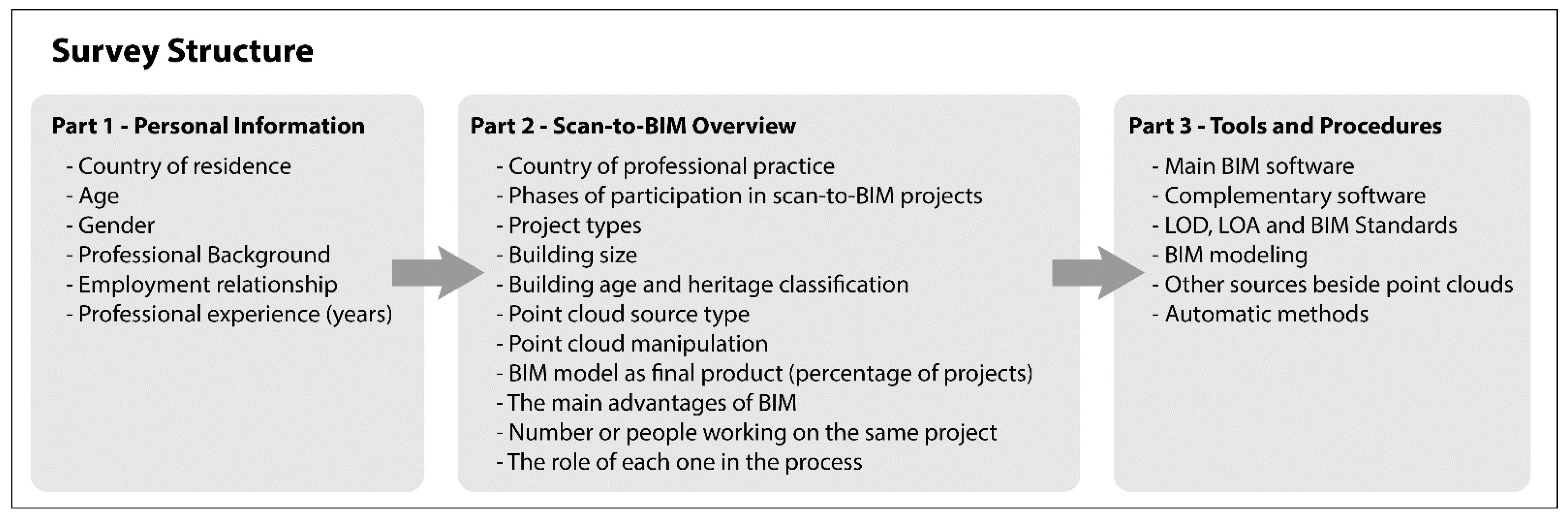
The survey structure has three parts (Figure 1). The first part aims to characterize the sample with questions such as age, time in the profession, experience with BIM projects, and residence. The second part of the questionnaire focuses on drawing an overview of the scan-to-BIM processes, with questions such as the building surveys’ location, type of project according to its function and historical characteristics, the number of people involved in the process, and procedures carried out preliminary to the modeling. Still in regard to the second part, it is common for professionals to collaborate with companies from other countries, which makes their work methodology reflect the needs of the country where the work will be done, and not necessarily the methodology applied in their own country. For this reason, we make a distinction between the place of residence and place of work. The data collected in this second part aims to understand the type of work developed in different parts of the world, and for what purposes BIM has been applied in these cases. In the third and final section, the questions are dedicated to the modeling process itself. At this point, the objective is to identify which stages of the scan-to-BIM modeling process professionals consider to be more laborious and could be optimized to streamline their internal methodology. It also seeks to identify new approaches or tools that can be integrated into the process. In total, 24 questions were created and distributed as follows: six questions in the personal information section, eleven in the scan-to-BIM overview section, and seven in the final section regarding tools and procedures. The questionnaire was structured to be anonymous, so no participant identification information was requested or recorded, and none of the questions were mandatory except for the one regarding the professional’s consent of participation.
Before the official application, the survey’s validation was done in two different stages between June and July 2020. At first, a questionnaire specialist validated the questionnaire’s structure and design; then three experts in the scan-to-BIM process validated the texts and questions by answering the preliminary version of the questionnaire and suggesting some adjustments to the final version of the survey.
The questionnaire started on 29 July 2020, and was active for three months until October 30. The invitation was sent to around 580 professionals and companies spread across all continents, and 189 people answered the questionnaire, which represents an adherence of about 29%. The participation was voluntary and without any financial remuneration. The only selection criterion applied was to invite professionals who work in any scan-to-BIM stages (building survey, data manipulation, BIM modeling, or creating the technical plans). The selection of companies and professionals to participate in the survey was made through market research on the internet and social networks. The companies selected were those in the survey and building survey field, in addition to architecture, engineering, topography, and restoration companies that include in their scope of work 3D laser scanning, photogrammetry, point cloud generation, and manipulation, or scan-to-BIM, or at least have experience in one of these areas. Besides companies, self-employed professionals and freelancers who offer some of these related services were also contacted. As the survey was conducted online, the self-declaration of eligibility was used. For the participant to have access to the survey content and questions, and to start participating, it was necessary to sign a consent form stating that they were at least 18 years old, have experience with architecture survey or BIM modeling using point clouds, and accepted to participate in the survey. The first contact with the professionals was done mainly by e-mail, the companies’ digital platforms, and social networks such as Instagram, LinkedIn, and Facebook. For the survey to be more comprehensive and representative, the questionnaire was sent to professionals from the six continents (Africa, North America, South America, Asia, Europe, and Australasia). During the three months of application of the questionnaire, the researchers monitored the origin of the responses to ensure that the survey had a global scope or good participation in all continents. When it was noticed that a continent lacked more participation, an internet search for companies and people operating in these regions was carried out, and new invitations were sent. In this way, it was possible to fill in the holes and carry out a globally representative survey.
3. Results
General Overview
The results and graphs presented below represent the number or proportionality of people who answered that specific question and not the questionnaire’s total number. For greater adherence, the authors gave participants the option of not answering all questions but only those that apply to their work or studies. Along with the general overview of scan-to-BIM obtained with this survey, it was also possible to analyze the progress and the use of reality capture technologies applied to heritage and to old buildings, and the use of BIM for these cases. To carry out this analysis, it was necessary to isolate and filter the responses based on some criteria, and a final number of 32 participants were selected. The first criterion established was the selection of participants who responded that they work with old buildings frequently or very frequently, whether they are listed buildings or not. The second criterion was to choose professionals who said they had worked with listed recent buildings frequently or very frequently. Finally, the third criterion was to filter among the professionals selected in the first and second criteria, who said they do not frequently work on non-listed recent buildings. The third criterion is essential to ensure that the selected professionals have historical or old buildings projects as their primary focus, thus ensuring a more accurate data analysis.
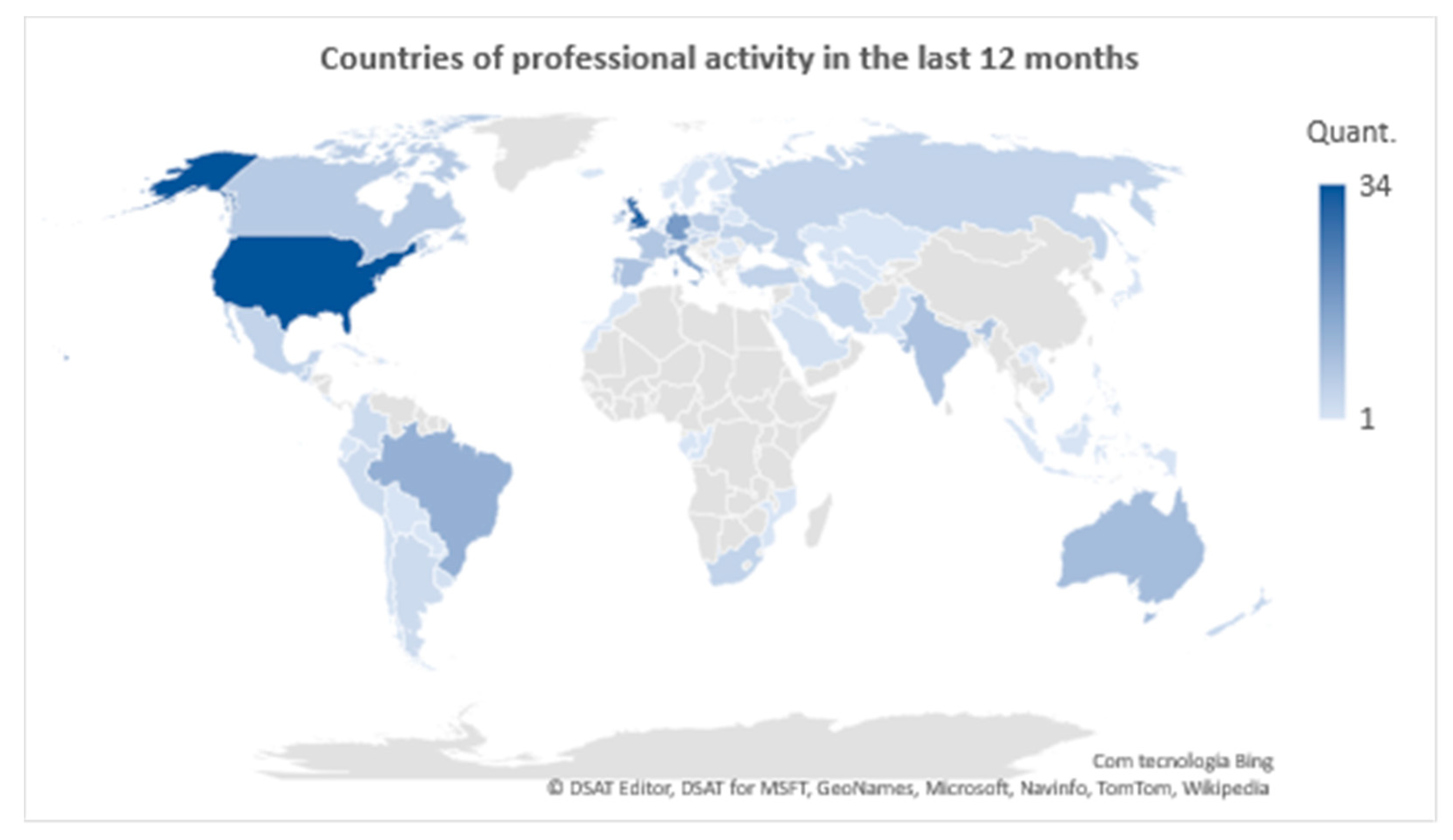
In total, 169 complete responses and 39 partial responses were collected, in a total sample of 208 participants residing in 54 countries covering six continents (Table 1). Although it is essential to locate where the participant is based, it is even more important to know for which country they work, as currently there are cases where professionals work remotely for companies located outside their territory or in close or neighboring countries. The survey asked the participant to indicate their three main marketplaces, if applicable, and in total, 78 countries were cited (Table 2), representing 40.0% of the existing countries according to the United Nations (Figure 2).
Among the participants, 50.6% answered that they also develop work for foreign countries other than their residence, and 15.1% did not indicate their residence as the primary market or workplace. In addition to these, 11.0% work exclusively for a foreign market, not having their residence as one of the three primary operations markets. The main marketplace for the interviewees is the United States, with 19.8% of the participants indicating it as a place of activity, although only 10.5% reside there. The United Kingdom appears in the second position, indicating 18.0% of the responses and only 5.8% of residents. The third place is Germany with 10.5% followed by Italy (9.3%), Brazil (7.6%), Australia (5.8%), India and Spain, both with 5.2%, and Portugal and France with 4.6% of the responses.
This research chose to use the seven continents division model to categorize the interviewees’ placement. Data from transcontinental countries such as Russia, Turkey, and Kazakhstan were grouped in the Europe and Asia category, as it is not possible to identify which part of the country (Asia or Europe) the participants in question reside and work. Thus, 51.5% of the participants work in Europe, 21.4% in North America, 18.4% in Asia, 11.6% in South America, 5.8% in Oceania (Australasia), and finally 3.9% in Africa.
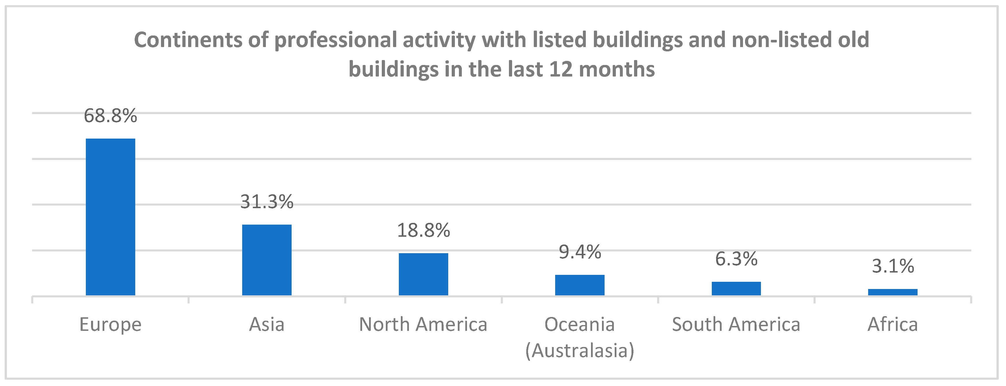
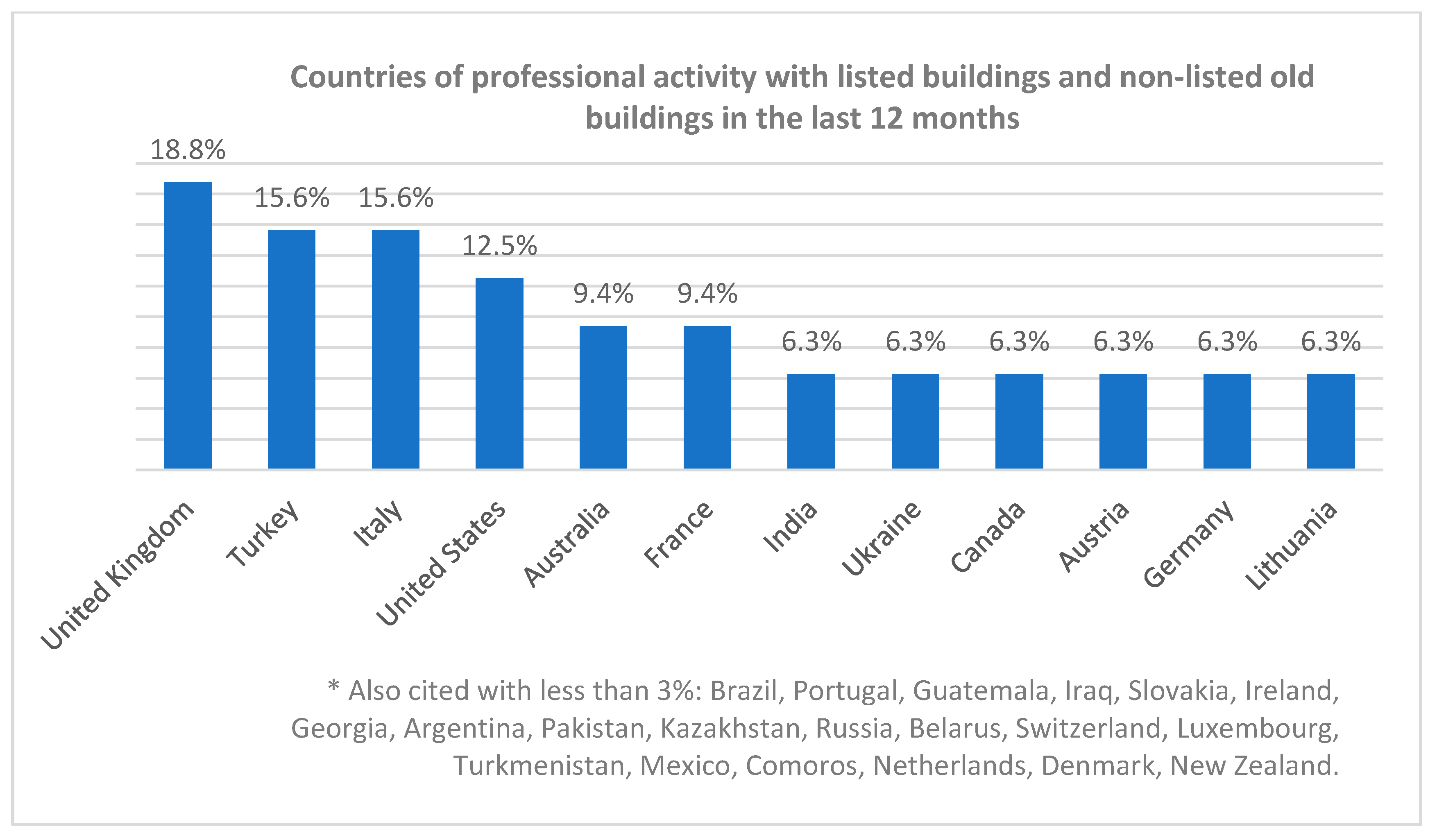
When dealing only with the data from professionals that work mainly on listed buildings and non-listed old buildings, the numbers are different. This time 68.8% mentioned that they work in the European continent, 31.3% in Asia, and 18.8% in North America. Oceania, South America, and Africa appear with 9.4%, 6.3%, and 3.1%, respectively (Figure 3). The countries most cited were the United Kingdom with 18.8%, Turkey and Italy with 15.6%, and the United States with 12.5%. Then comes Australia and France with 9.4%, India, Ukraine, Canada, Austria, Germany, and Lithuania with 6.3% each (Figure 4).
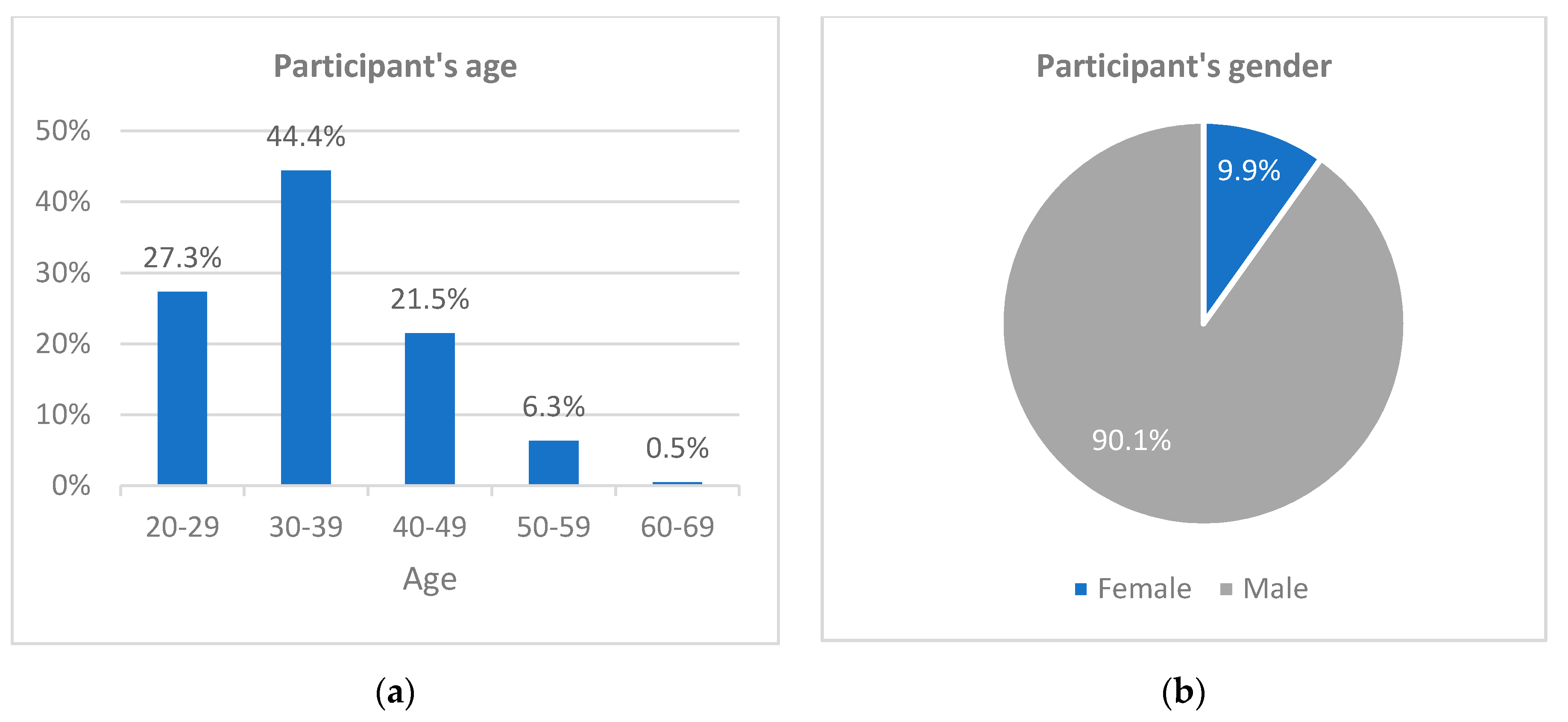
Regarding the participants’ age, 71.7% indicated that they were under 40 years old, 44.4% between 30 and 39. The research showed a low presence of women in this field of work with only 9.9% of the total participants identifying as such. The remainder, 90.1%, identified as male, and none identified in the category “other” (Figure 5).
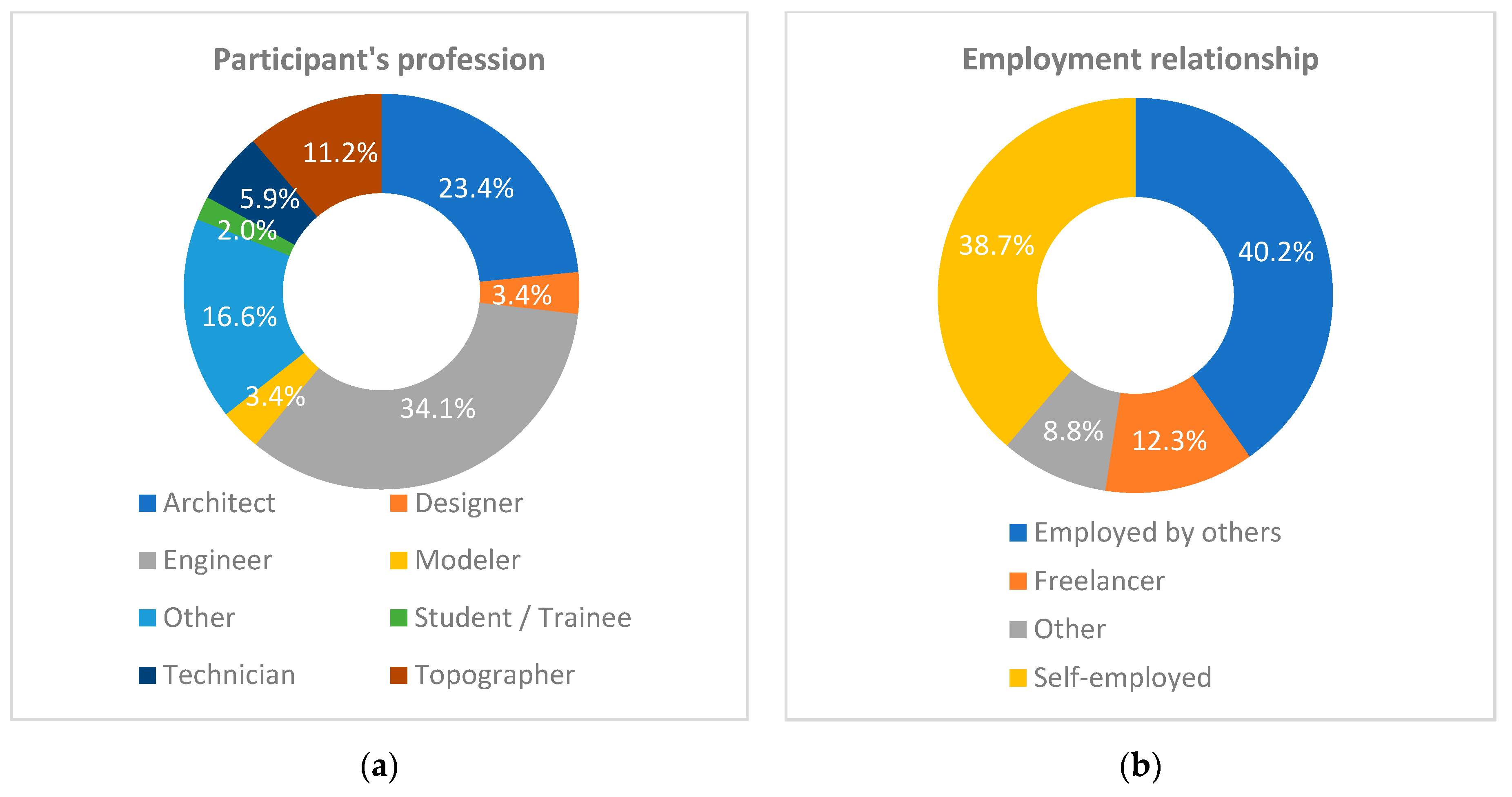
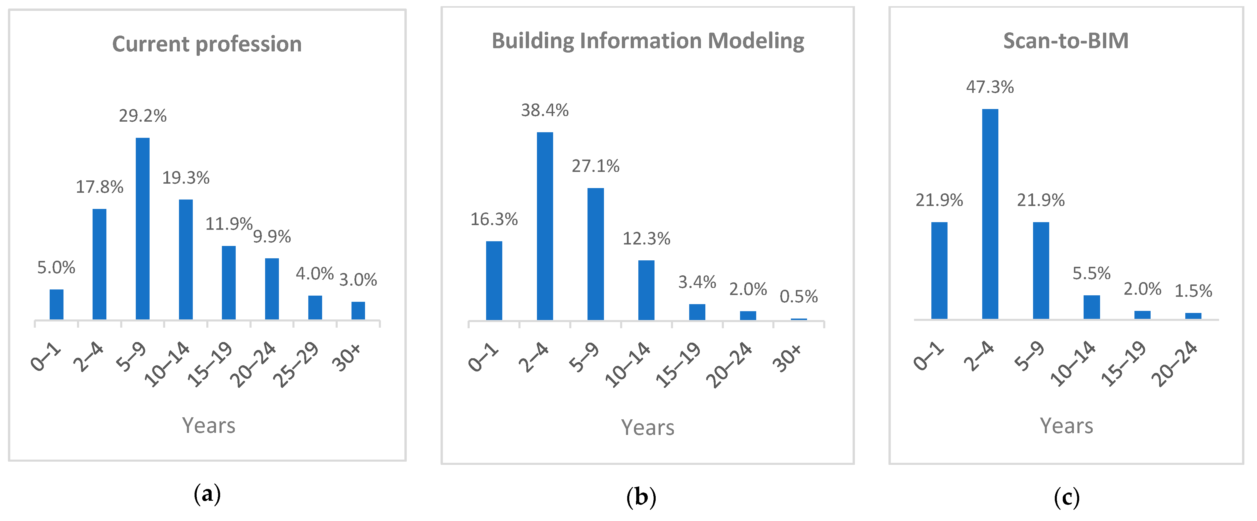
In a scan-to-BIM workflow, there are many different roles, functions, and agents within the process. The majority (34.1%) indicated engineer as their profession, followed by architect (23.4%), topographer (11.2%), technician (5.9%), designer (3.4%), modeler (3.4%), and student (2.0%). Positions such as surveyor, BIM manager, archaeologist, CEO, and geologist were also mentioned, among others. Regarding their employment situation, 40.2% indicated that they work for others, while 38.7% are self-employed, and 12.3% said they work as freelancers collaborating with some companies without maintaining an employment relationship (Figure 6). The average length of professional experience aims to reflect the participants’ level of maturity when it comes to the escalation of specificity of their work in the field researched. As a result, while in their general profession 77.2% indicated having more than five years of experience and 48.1% indicated having more than 10 years of experience; working with BIM, 45.3% said they had more than 5 years of experience and with scan-to-BIM only 30.9% (Figure 7).
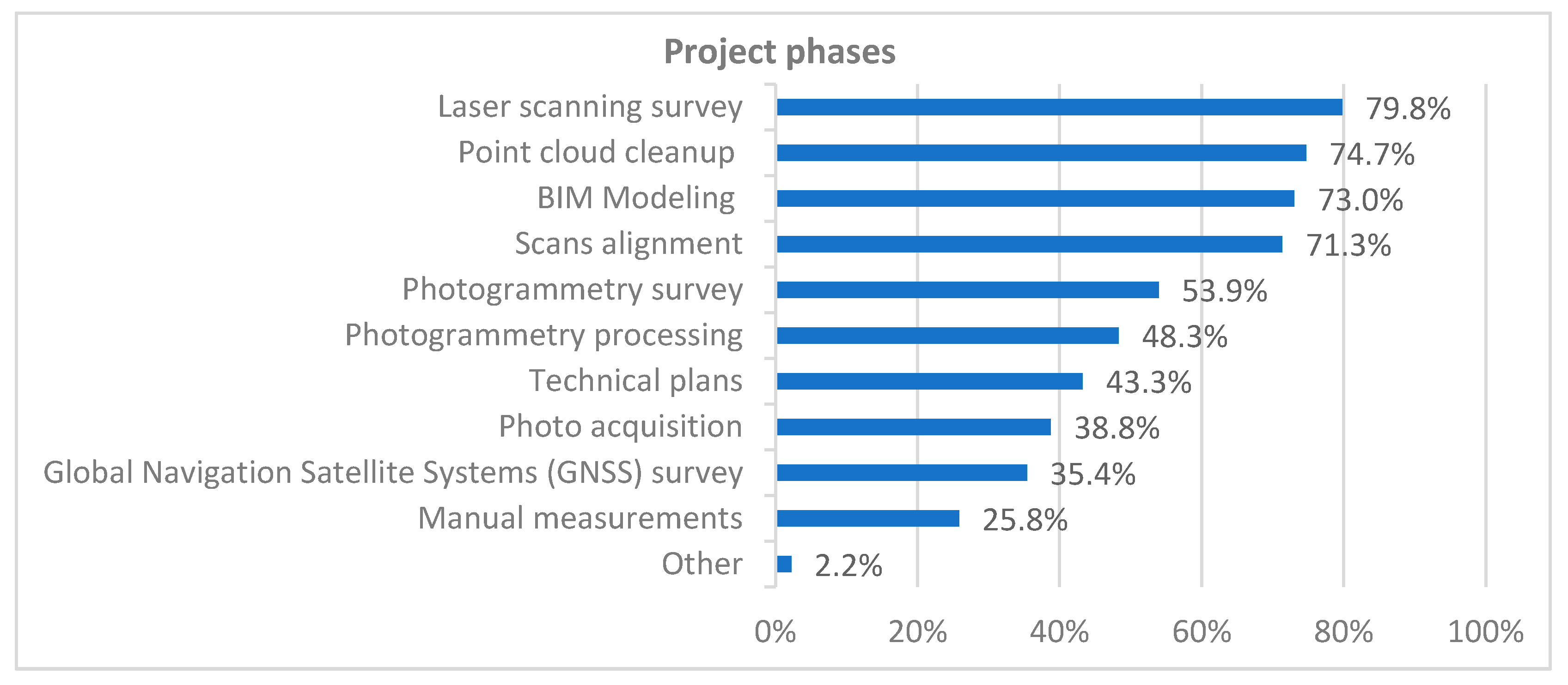
There are many roles in a scan-to-BIM process and, although a single professional can perform all of them, it is common to divide the work with other professionals in a multidisciplinary team. In this subject, more than 70% of the participants indicated that in the last 12 months, they worked on the main stages of scan-to-BIM, namely laser scanning survey, point clouds processing, registering and cleaning up, and BIM modeling. About half of the interviewees indicated participating in the procedures involving the photogrammetric survey and processing. Only 43.3% said they participate in creating technical plans, which indicates that the creation of the BIM model is prioritized in these processes. Traditional measurement techniques are not entirely discarded when using laser scanning and digital photogrammetry; 38.8% of participants indicated that they perform the photographic survey; and 25.8% manual measurements (Figure 8).
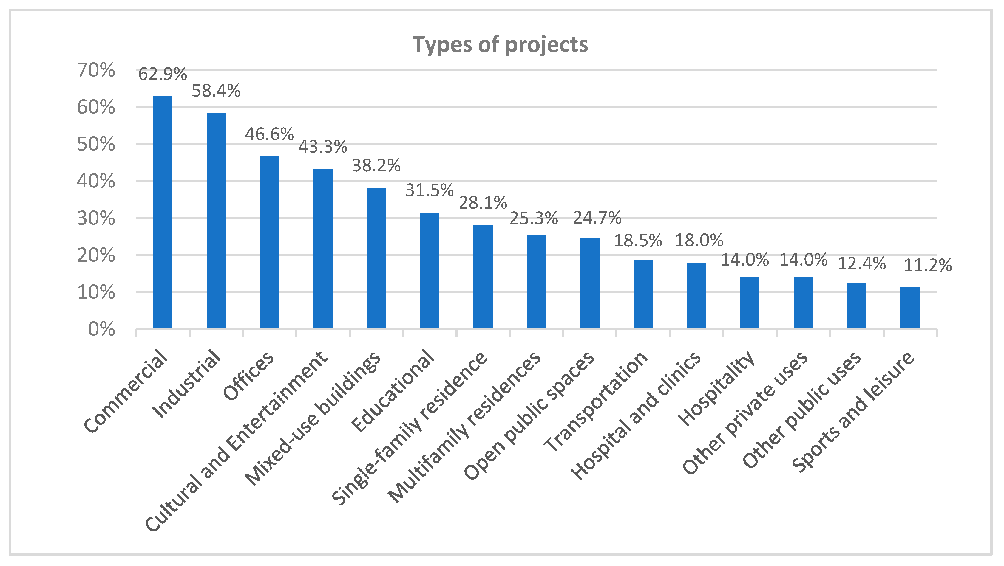
In addition to understanding the professionals’ profile, the survey sought to identify the purpose of their adoption of architectural survey technologies combined with BIM. The participants answered in what types of scan-to-BIM projects they had worked on in the last 12 months, and a tendency towards greater use of these technologies in larger or more complex projects was identified in the responses. This tendency is explained by the fact that a survey using traditional techniques would be more laborious, costly, and imprecise in these cases. The types of projects that these technologies were most used were 62.9% on commercial projects, 58.4% industrial projects, 46.6% offices, 43.3% projects of cultural or entertainment enterprises, and 38.2% mixed-use buildings. For residential buildings, their use was limited to 28.1% for single-family residential (houses and apartments) and 25.3% for multifamily buildings (apartment buildings) (Figure 9).
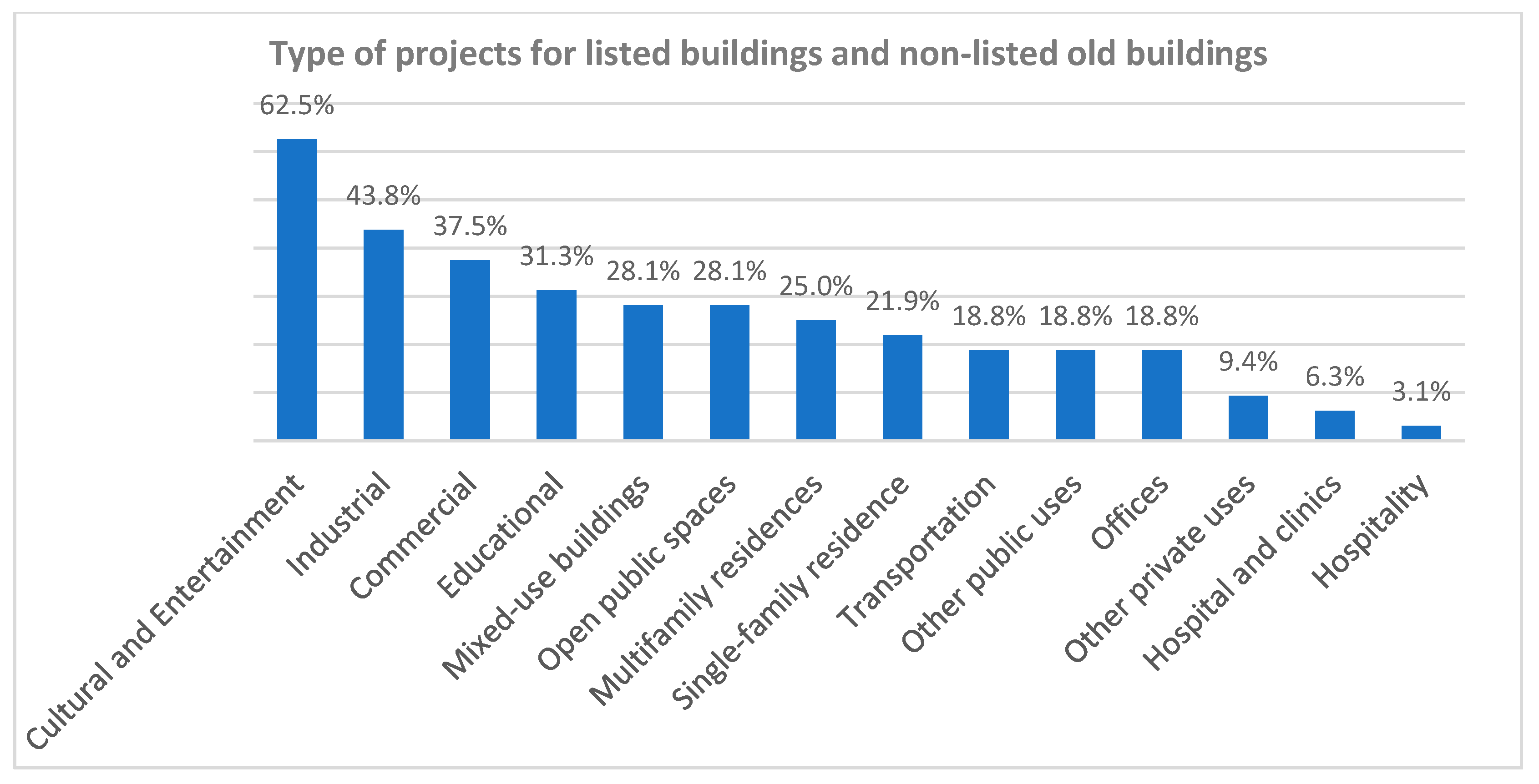
When dealing only with heritage buildings and old buildings, the most mentioned type of project was cultural and entertainment with 62.5%, unlike the general scenario, where the main types of projects were commercial, industrial, and office projects. The second most cited were industrial types with 43.8%, followed by commercials with 37.5%; educational with 31.3%; open public spaces, and mixed-use buildings with 28.1%. Multifamily residences appear only in the seventh position with 25.0%, single-family residences with 21.9%, and offices with only 18.8% (Figure 10).
Referring to the buildings’ size, the survey identified a slight tendency to apply these technologies in medium-sized buildings, with a built area of between 1000 m² and 5000 m². The use in large projects (larger than 5000 m²) and small projects (less than 1000 m²) were equivalent with a little more frequency in the small category (Figure 11).
Regarding the characterization of the building by its age and classification as a listed building, the trend identified was a prevalence of the use of laser scanning and photogrammetry in the digital survey of non-listed recent buildings up to 100 years old; 44.4% indicated that they work with these cases frequently or very frequently. This number was 25.3% for non-listed old buildings, and for listed old buildings, it dropped to 20.2% (Figure 12).
The use of point clouds generated from surveys with 3D laser scanning was predominant in 92.7% of the cases, and 46.0% of the participants indicated using it exclusively. On the other hand, 46.7% of professionals use them combined with point clouds generated by digital photogrammetry. Finally, only 5.5% use photogrammetry as the only tool to capture reality.
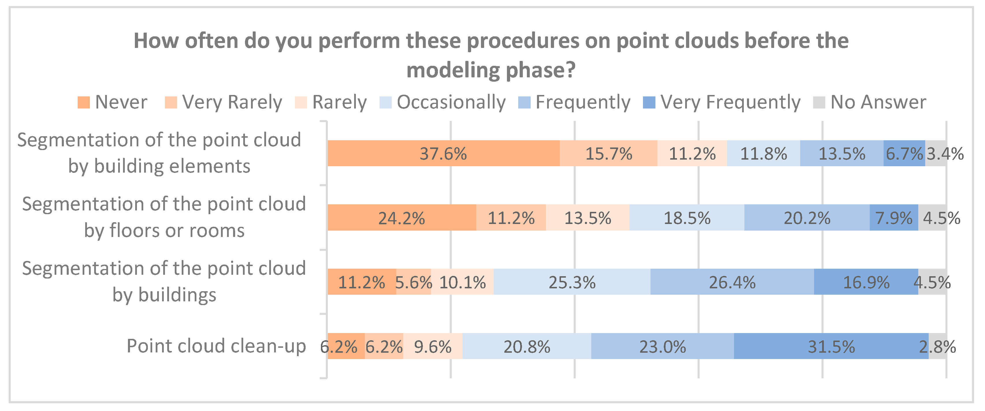
Point clouds may often not be ready to be used directly in BIM tools, requiring some cleaning, segmentation, or parsing procedures. This happens because of unwanted artifacts and points generated by mirrors, glass, or other reflective surfaces in the environment. The presence of vegetation, trees, people, or unwanted furniture in the building can also create a noisy point cloud. For these cases, it is recommended that a point cloud cleaning be done before using it for modeling. Amongst the participants, 54.5% of them indicated that they do this procedure frequently. The point cloud segmentation can occur when there is a need to divide the project because of its size or to model something in isolation, reducing computer processing with unwanted parts. Of the participants, 43.3% indicated segmenting a project by isolated buildings frequently or very frequently. This number drops to 28.1% when segmenting the same building by floors and 20.2% for isolated elements of the building, such as doors and windows, among others (Figure 13).
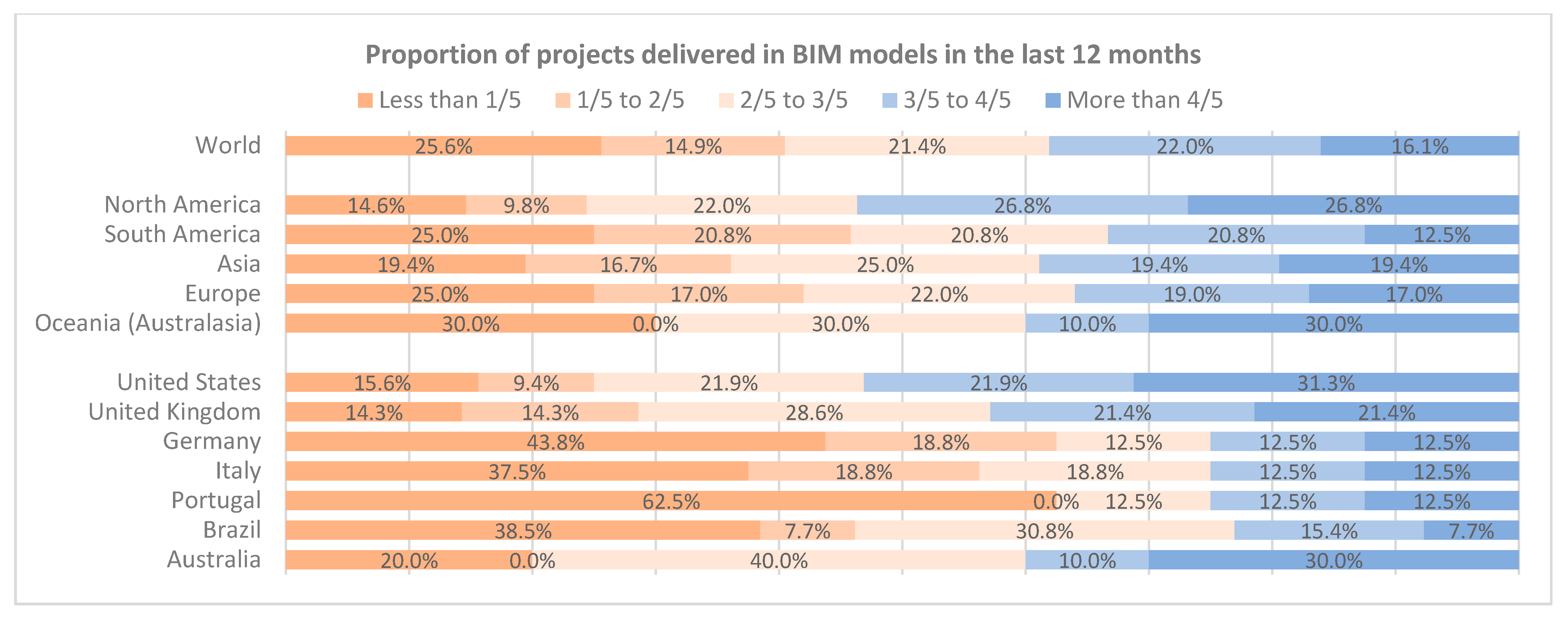
The choice of creating BIM models from the architectural surveys happens, in most cases by client demand, and does not necessarily reflect the main workflow of the survey companies. A question was made to understand the adoption of BIM in the various markets. Participants were asked the approximate proportion of their projects that had used point cloud in the last 12 months with a BIM model as a delivery product. In the global analysis, 38.1% of the participants indicated that at least 3/5 of the projects they worked on in the last year required a BIM model, and 16.1% indicated that this happened in at least 4/5 of them; 25.6% indicated that the BIM demand occurred in less than 1/5 of the projects. When analyzing these data by continents, there is a more significant advance in BIM themes in the North American continent where the number of people who indicated to use BIM in at least 3/5 of the projects was 53.6%, and 26.8% indicated that they use it in at least 4/5 of the projects. South America, Asia, Europe, and Oceania (Australasia) presented similar numbers between them where BIM was used in at least 3/5 of the projects, 33.3%, 38.8%, 36.0%, and 40.0%, respectively. However, Oceania presented the highest proportion of participants who indicated use in at least 4/5 of the projects (30.0%) (Figure 14). The adherence to the questionnaire by professionals working in Africa was not sufficient for the data from that continent to be analyzed in isolation; therefore, they were included only in the global analysis.
The research divided the answers by the six most cited countries in the survey in order to analyze the trend and adoption of BIM for works with point clouds. United States, United Kingdom, and Australia had the highest rates of BIM usage. In the first 53.2% of people indicated that they use BIM in at least 3/5 of the studies and 31.3% indicated that they use it in at least 4/5. In the United Kingdom, the numbers were 42.8% and 21.4%, and in Australia, 40.0% and 30.0%. Germany, Italy, and Portugal presented equal numbers for BIM usage in at least 3/5 of the projects (25.0%) and high rate of people using it in less than 1/5, specifically in Germany (43.8%), Italy (37.5%), and Portugal (62.5%). Brazil appears with similar numbers to Germany and Italy, but with a more significant proportion of people who used BIM in at least 2/5 of the projects (Figure 14).
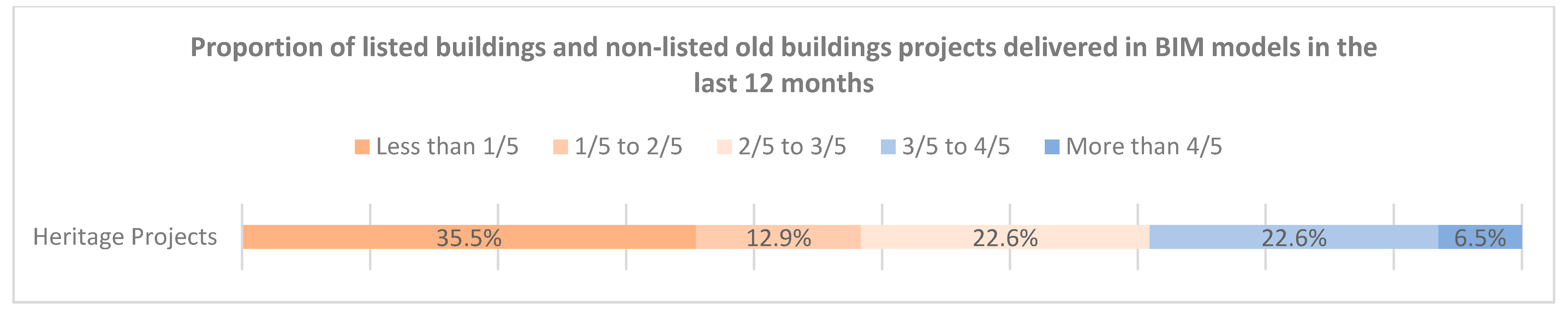
The use of BIM in historical and old buildings projects proves to be even more challenging due to the complexity of the object. Only 29.1% of people indicated working with BIM in at least 3/5 of the projects, and only 6.5% of these indicated working in more than 4/5 (Figure 15). The percentage of people who worked with BIM listed buildings and non-listed old buildings in less than 20% of the projects was 35.5%, a high number compared to the general overview of the previous section that was 25.6%.
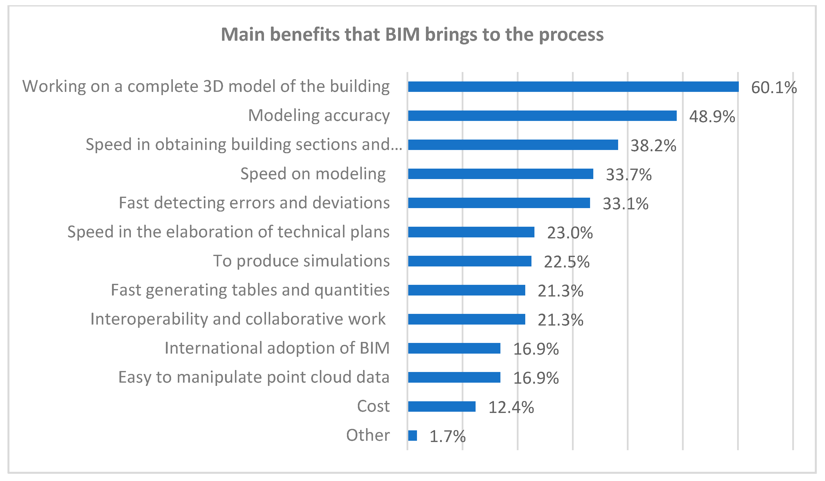
Even when BIM is not a requirement of the client who commissions the project, many professionals prefer to use BIM tools as they bring some benefits to the geometric reconstruction from point clouds. Participants were asked the main benefits they identified in adopting BIM tools to develop their work to capture and rebuild the constructed reality (Figure 16). Of them, 60.1% cited as its main advantage, working with a complete 3D model and not only with isolated plans, cuts, and elevations. The precision of the modeling that these tools bring to the process was pointed out by 48.9% of people, and 38.2% indicated that the speed in obtaining sections and elevations is a determining factor for using the BIM methodology. The speed in modeling and ease in detecting errors and deviations in projects were marked by 33.7% and 33.1% of people surveyed, respectively. The options least mentioned by the participants as benefits that BIM brings were cost (12.4%), the ease of manipulating point clouds with BIM tools (16.9%), and the international adoption of BIM (16.9%).
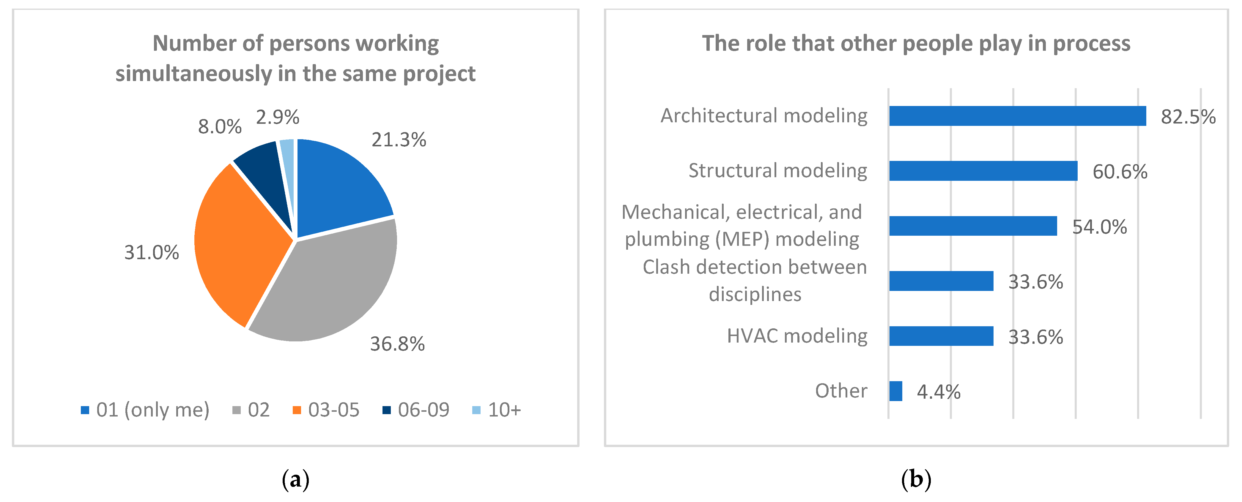
Collaborative work is one of the main characteristics and benefits that BIM brings to the design process. Although in the stage of constructing an as-built model, the focus is not on developing new designs; it is possible to integrate people into the process to explore the specialties of each professional, or minimize the time spent in the reconstruction of the model. Of the survey participants, 78.7% indicated that the projects usually require at least two people, and 41.9% indicated that at least three people work together on a single project. The role that these extra people play in the process varies. 82.5% indicated that they help in the architecture modeling, 60.6% in structure modeling, and 54.0% indicated that extra people work in the development of models related to the disciplines of mechanical, electrical, and plumbing (Figure 17).
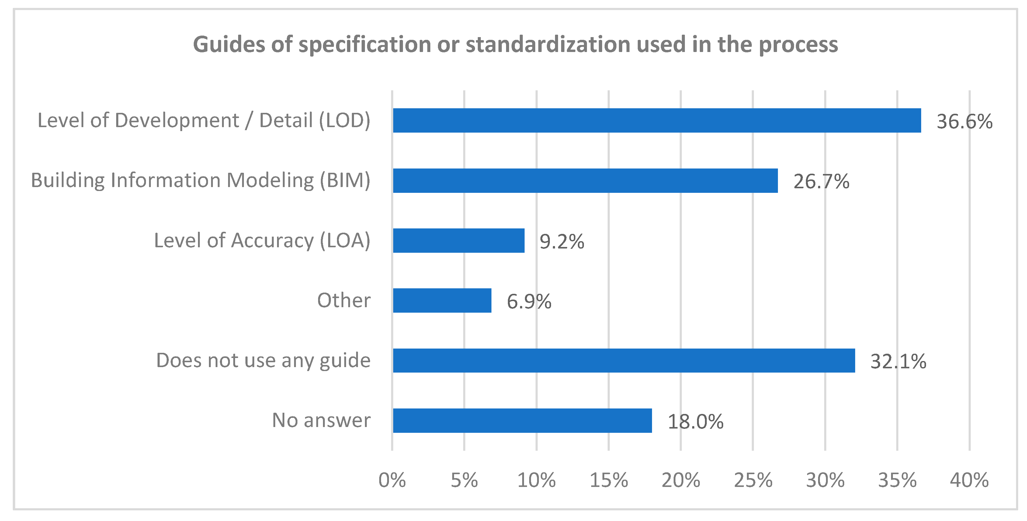
The guides and standardization aimed at developing BIM works are increasingly common and more used to support the work of companies. Some countries already have specific standard guides, while others are still developing their own. The study sought to understand how this was reflected in scan-to-BIM companies, and identify the guides that professionals use most in their work. Every digital model is an abstraction as well as a simplification of the real object that was captured. Even the most complete and accurate model created will not have all the characteristics and imperfections present in the existing object. To choose the level of detail (LOD), level of accuracy (LOA), and tolerance that each model needs to achieve, the purpose for which this model will be created must be well defined [20,24]. Without knowing the purpose, it is impossible to guarantee that the model created will meet the client’s needs and that there are no over-modeling or under-modeling problems. Within a company, with many people involved in the process, it is common for the model LOD and LOA to be defined between the client and the project managers and then forwarded to the field and modeling teams. In our research, we did not try to understand how the definition of LOD is done, but that, once defined, an attempt was made to understand the subsequent flow. Among the participants, 36.6% said they use guides related to the level of detail (LOD), the most cited being the Level of Development Specification of BIMForum developed from the document AIA G202-2013 Building Information Modeling Protocol Form of the AIA. On the theme of Building Information Modeling, 26.7% of professionals indicated using some guide, with citations to internal guides developed in the companies, guides from their own country, and the ISO 19650—Organization and digitization of information about buildings and civil engineering works, including building information modeling (BIM)—Information management using information building modeling. The level of accuracy (LOA) was cited by only 9.2% of participants, emphasizing the level of accuracy (LOA) Specification version 3.0 guide developed by USIBD. Also, 32.1% of the participants indicated that they did not use any guide, and 18.0% did not answer the question (Figure 18).
The most cited digital tools directed to BIM modeling were the Autodesk Revit with 89.3%, Graphisoft Archicad with 14.5%, and Tekla from Trimble with 6.1%. In addition to the base modeling software, in many cases it is necessary to use other tools that complement the work, be it to facilitate the visualization and manipulation of the point cloud, completion of technical plants, or even do joint work when modeling. The participants’ most cited complementary software was Autodesk Recap, with 71.0% of the mentions, followed by Autodesk Autocad 51.9%, Cloudcompare 34.4%, and Agisoft Metashape 20.6% (Figure 19).
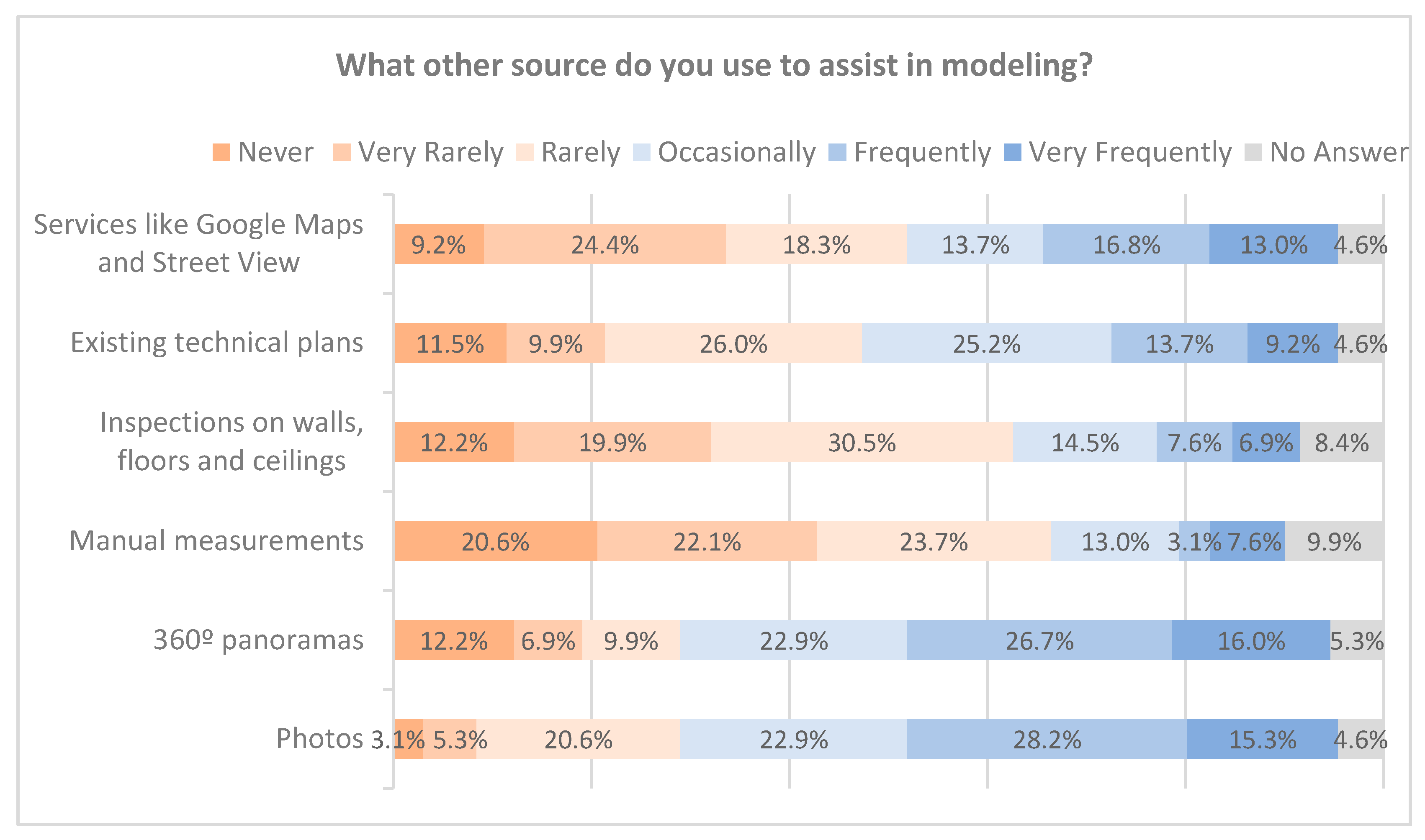
With the point cloud, it is possible to obtain much information about the digitized building, but in most cases, it is necessary to use other sources for a better understanding of the object, whether in its volumetry, materiality, or structural systems. Professionals were asked what complementary sources they use the most in their modeling work are, and the most cited were the 360° panoramas generated by scanners and photographs taken on-site. In these cases, 42.7% and 43.5% of people said they use them frequently. On the other hand, the least used sources were inspections in building elements and manual measurements made on-site; in these cases, 62.6% and 66.4% said they rarely use them in their projects. Finally, 22.9% of participants mentioned using existing technical plans frequently to assist modeling, and 29.8% mentioned that they often use digital services such as Google Maps and Street View (Figure 20).
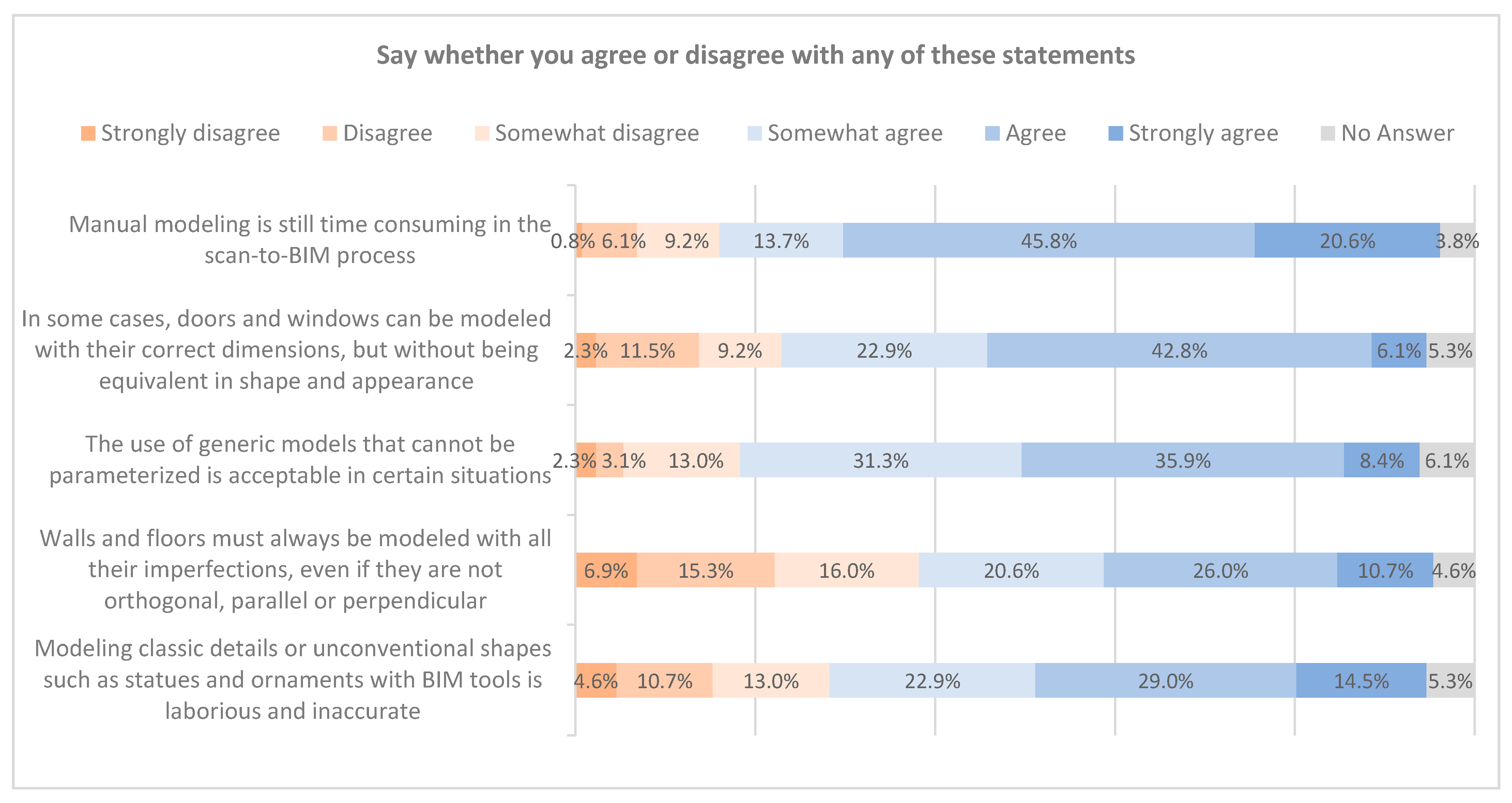
The research presented some statements about the scan-to-BIM modeling process’ characteristics to collect opinions and measure the trend in each of them. Out of the total interviewed, 80.1% of participants tend to agree that manual modeling of geometry from point clouds is still a time-consuming step in the process. As the level of detail is something particular to each project, this is also reflected in each project’s modeling solutions. In this theme, 71.7% of participants say they tend to agree that it is acceptable, in some situations, to model doors and windows in a simplified way as long as they maintain accuracy in their main dimensions, and 75.2% say that it is acceptable to use generic models that are not parameterizable in certain situations. Another critical point within scan-to-BIM is modeling classical shapes or unconventional or organic geometry, such as statues and ornaments. In these cases, 66.9% say that, in a way, these modeling procedures are often laborious and inaccurate with traditional BIM tools. The last statement referred to the themes of the level of accuracy, approximation, and tolerance applied. It was asked whether the geometry of the walls and floors should be modeled with their imperfections, even if they are not parallel, perpendicular, or orthogonal, and 57.6% of the participants tend to agree that it is necessary to model these elements with all their imperfections, while 38.2% tend to disagree with this statement (Figure 21).
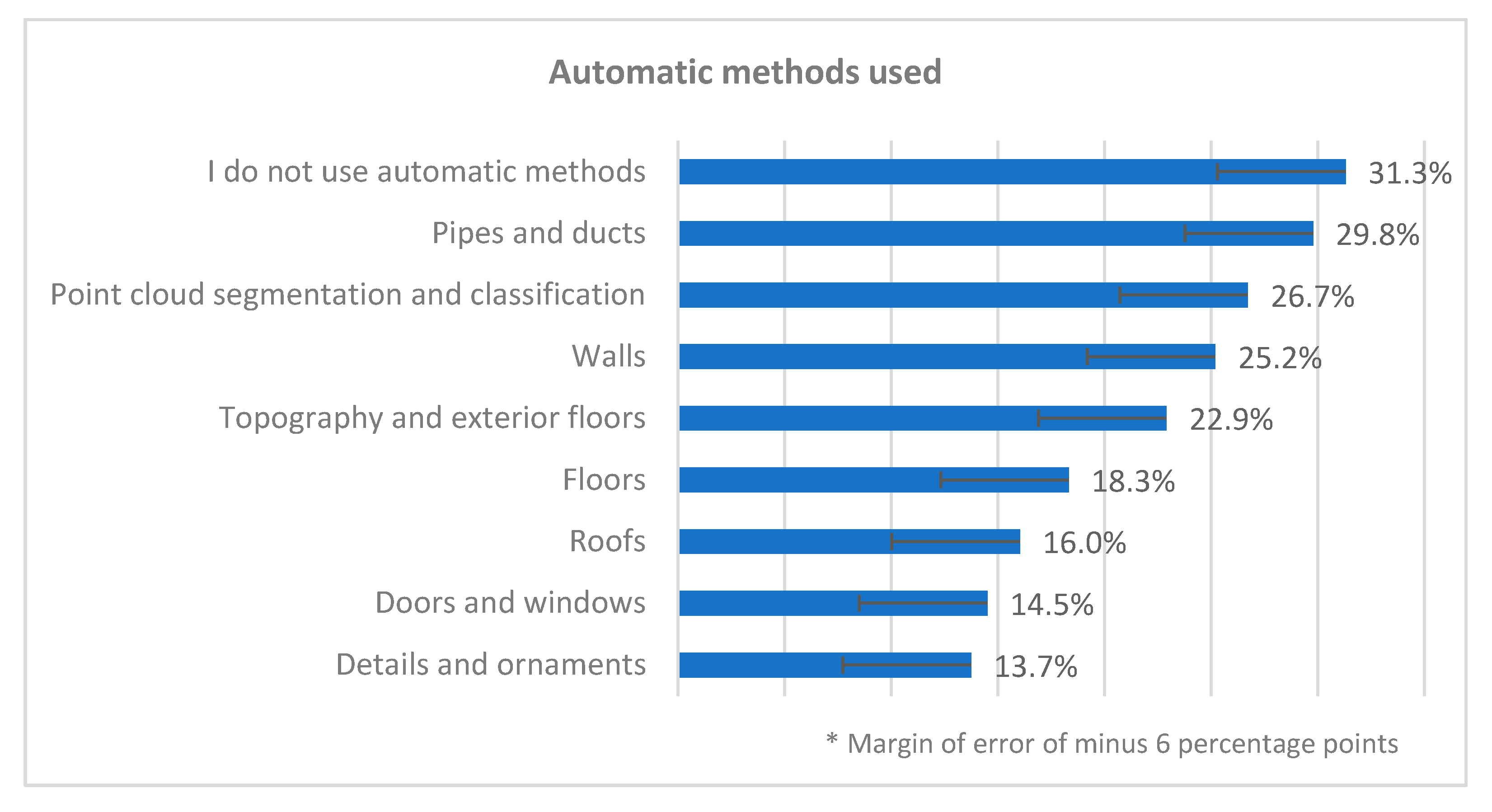
The last section of the questionnaire was dedicated to identifying the types of automatic approaches most used by participants and for which elements they would like to have a tool for automating modeling procedures. Of the participants, 31.3% indicated that they did not use any automatic modeling method, whereas 29.8% use some automatic approach to model the pipes and ducts. Also, 26.7% cited using automatic methods to manipulate the point cloud, 25.2% for walls, and 22.9% for topography and external floors. The least mentioned elements were the modeling of details and ornaments (13.7%), doors and windows (14.5%), and roofs (16.0%) (Figure 22). It is important to emphasize that a particular inaccuracy was identified in the answers to this question because some participants might have had another interpretation of the meaning of automatic methods. This was inferred when analyzing the tools cited for automation, where some participants cited tools that in their native form do not present means of automation. For this reason, the survey identifies a possible difference of up to 6% in the affirmative responses. The Faro As-Built, EdgeWise, and BIMm Tool stand out among the primary tools cited for automation. The reasons cited by some for not using any automatic method were the lack of a tool with reasonable accuracy for this purpose, the fact that the tools still reconstruct the geometry with many errors, and that they do not work for all situations.
4. Discussion
The questionnaire was developed to be comprehensive in the topics addressed (building digitalization, point cloud manipulation, and scan-to-BIM modeling) by consulting professionals from various parts of the world to have a robust and diversified sample. As seen by the results, working with digitization and architectural reconstruction of pre-existence is not the same in all countries. The demands of the internal market influence the way of dealing with these projects; this way, some themes can be more or less developed compared to neighboring countries [60]. The research sought to understand these differences in work and how the scan-to-BIM process has developed worldwide.
The sampling was broad and comprehensive, 78 countries were cited as a market for professional activity by the participants, and 50.6% develop work for countries other than their country of residence. This number shows how distance work is crossing borders and presenting itself as a viable alternative for expanding its work and minimizing the negative impacts that events such as the COVID-19 pandemic can bring to companies’ workflow. It was noted that the questionnaire had low support in East Asian countries, Central Africa, and Francophone countries. This might be the fact that it was supplied only in English and Portuguese, which drove away people who did not speak those languages.
Collaborative work among professionals from various disciplines is a characteristic of BIM [4,61], and this reflects the professional profile of the surveyed participants, with the presence of architects, engineers, surveyors, designers, and others. Among them, 78.7% said that they usually work with other professionals on the same project. The intent is usually to reconstruct the architectural model aligned with complementary disciplines such as structural, electrical, and mechanical, to verify any clash between disciplines. This proves the importance of collaborative work even when dealing with as-built projects.
The creation of BIM models from point clouds was recently incorporated into most participants’ work scope; 69.2% indicate working with these processes for only four years. The countries where BIM has been most present in pre-existence architectural survey work are the United States, United Kingdom, and Australia. This reflects BIM’s advance in the AEC industry of these three countries [60,62,63]. Data from other European countries showed that the demand for BIM projects is still no higher than that of conventional projects. In Portugal, 62.5% of the professionals indicated use only in up to 1/5 of the projects, reflecting that incorporating BIM in the country still happens hesitantly [64]. Brazil also presented numbers showing an increase in BIM accession compared to some of the leading countries in Europe, where 53.9% indicated using BIM in at least 2/5 of the projects. This data may be related to recent movements within Brazil towards the greater use of BIM in public works, which has caused many professionals to incorporate it as a principal work methodology [65,66]. The global adoption of BIM has increased annually, together with the demand for professionals who have experience with this methodology. Other studies show that BIM application is on the rise, as is the encouragement by governments and organizations to facilitate and accelerate its implementation [8,59]. The survey companies and professionals are intermediary agents in the BIM process, so the requirement for using BIM software to carry out scan-to-BIM work is mainly from the client and not from the companies that carry out the surveys. Some authors address BIM implementation and its challenges involving the high initial cost of implementation, the need for team training, lack of professionals in complementary areas to carry out collaborative work, and the lack of information on BIM rules and BIM standards [8,9,10]. The increased use of BIM by AEC companies in general reflects the requirement of BIM models for reality capture work. This new working method tends to create a demand for incorporating BIM as a delivery product for survey companies that do not yet work with it.
When isolating the answers of professionals who work with heritage and with old buildings, it was possible to draw a parallel with the data obtained from the general overview. There is a significant concentration of professionals working in Europe, representing 68.8% of the responses; Asia appears second with 31.3% and North America with 18.8%. This data differs from the general scenario where Europe was also with the highest concentration but with a lower percentage (51.5%), while North America and Asia were 18.4% and 11.6%, respectively. It was also possible to note that the use of BIM for these cases is still very limited, only 6.5% indicated that they work with BIM for listed buildings and non-listed old buildings projects in more than 4/5 of their projects, while 35.5% said they chose to use BIM in less than 1/5 of them. This low adherence to BIM for these cases shows that these processes still need to mature to be widely integrated by the market. The need for highly trained professionals to develop complex models common to historical or old buildings and the time required for these models to be executed make working with BIM challenging for the professionals and clients involved in the projects.
In Europe, 80% of buildings from before 1990 do not yet have a BIM model [11]. For these cases, laser-scanning and photogrammetry survey techniques can be fast, viable, and present high-precision solutions, especially in large or complex buildings. This survey identified that the primary type of projects in which scan-to-BIM companies operate are commercial, industrial, office buildings, with at least 50% of participants indicating that they have worked in these types of projects in the last 12 months. Another fact that corroborates the statement is that 76.9% of the participants regularly work on projects with a gross building area between 1000 m² and 5000 m²; the value drops to 62.4% for projects up to 1000 m².
A building’s complexity and size are some of the reasons for using laser scanning and photogrammetry techniques since they facilitate the architectural survey. However, the excess complexity found in old buildings can be a factor that makes modeling in BIM software a challenging task. About 45% of participants rarely worked with old buildings (over 100 years of age), while with buildings under 100 years of age, this number drops to 28%. These numbers may be related to the fact that BIM tools are optimized to develop new projects or recent buildings with a conventional structural system. Historical architecture usually presents irregularities in its forms and little uniformity between its elements, which makes the creation of BIM models for this purpose a complex, time-consuming, and, consequently, more expensive task. For 66.4% of the participants, it still proves to be laborious to model details of classical architecture or unconventional forms, such as statues and other elements, and often may not present accurate results. Also, 80.1% of the people surveyed agree that manual modeling is very time consuming in the scan-to-BIM process, which can be aggravated when working with classical architecture due to its high degree of complexity.
The great benefit that BIM brings to the representation and modeling of a preexisting architecture is that it saves time and has better precision in specific tasks [67]. The main advantage, pointed out by 60.1% of participants, is the possibility of working on the complete model of the building and not on isolated plans. This makes the model more faithful to reality and more reliable since errors are minimized, making the model more accurate, another essential factor that 48.9% of the participants remembered. In addition to the accuracy of the digital model, another important factor is the possibility of speeding up some tasks. As stated earlier, the time spent modeling is something to be considered. BIM allows some tasks to be dynamized, such as creating elevations and sections much faster than conventional technical drawing software.
Currently, most of the BIM modeling from point clouds happens manually [35]. A total of 31.3% of the participants said they did not use any automation technique, and some of the justifications for not using it were the lack of accuracy the current tools deliver. Besides, the need for much rework to fix and verify the geometry was mentioned as well as the fact that the tools cannot be used in all cases. Even though the scan-to-BIM process brings agility in executing some procedures, such as the acceleration of the field survey, modeling, and creating graphic pieces, there is much room for improvement and optimization. Many researchers have developed studies to overcome this situation and reduce the time consumed in manual modeling tasks; some studies deal with the automatic reconstruction of walls [39,68,69], floors [68], pipes, and mechanical, electrical, and plumbing (MEP) components [46], and other building elements [13,70]. Reducing time in creating BIM models from the point clouds can make this process more accessible and encourage greater adoption of BIM by companies and clients.
Other reasons cited by participants as factors that hinder the use and full implementation of BIM in projects to capture the preexisting reality confirm the findings of other correlated studies. Faithfully representing and modeling elements of historic buildings is not easy, and current BIM libraries are still small and not fully comprehensive [71,72], which makes it necessary to create or adapt custom BIM elements for each of situation [73], thus making the process slower than usual. Scan-to-BIM professionals widely use the Autodesk Revit software to create BIM models, but it still has limitations in some situations. The survey showed that many professionals feel the need to model unconventional shapes or surface deformations, but with traditional BIM software, this task becomes difficult; Andriasyan et al. shows in their research that Revit has limitations for modeling non-regular surfaces and proposes alternative solutions such as combining programming codes and interoperability with different software [48].
5. Conclusions
This research aimed to draw the global overview of scan-to-BIM through the application of an online survey with expert professionals in building survey, point cloud data manipulation, or BIM modeling from this data. With the results obtained in this research, it is possible to draw a point of comparison and evolution of scan-to-BIM practices globally and connect them to research and investigations carried out in academia.
The use of current survey techniques such as 3D terrestrial laser scanning and digital photogrammetry has increased over time, and consequently, the choice of BIM as a working methodology for these cases has also increased. To understand the paths the market has taken and to identify possible difficulties along the way, it is essential to address the way professionals in this area work. Hence, collecting information and feedback on these processes proves to be valuable for this purpose. This study was developed to collect data and draw a general overview of scan-to-BIM worldwide to contribute to other researchers focused on the reality capture issue.
This research identified the main markets, types of projects where these technologies have been used, and the advancement in BIM application in these cases. Even though there is vast expansion in its use, BIM is still a field where many professionals have much resistance. Although professionals identify the accuracy, speed of modeling and creation of technical plans, as well as the possibility of working with the complete 3D model and not only with isolated plans as benefits that BIM brings to the process, only 38.1% of them work with BIM in at least 3/5 of their reality capture projects. This number drops to 29.1% when it comes heritage and old buildings projects. These data show that, despite the benefits BIM often brings, the difficulties encountered to develop work quickly and efficiently are considerable, which prevents a complete transition to this work methodology.
The main conclusions and findings that can be extracted from this research are:
- More than 50% of participants develop work for countries other than their country of residence, which shows that remote work is a viable option for these companies, which is very important to overcome similar periods to those of COVID-19.
- Collaborative work and interoperability between professionals from different disciplines is widespread. More than 78% said projects usually involve more than one person.
- The use of BIM for reality capture projects is on the rise, with some countries having greater adoption than others. Almost 40% of professionals indicated using BIM in at least 3/5 of the projects. The United States was the country where this number was the highest (53%), followed by the United Kingdom (42%) and Australia (40%). The numbers from other countries such as Germany, Italy, Portugal, and Brazil were lower; on average, only 25% indicated using BIM in more than 60% of projects.
- The use of BIM to deal with heritage and old buildings projects proved to be limited. Only 29% indicated using BIM in at least 3/5 of the projects.
- Although the complexity of the building to be surveyed is one of the factors in choosing to use 3D laser scanning or photogrammetry to carry out the survey, it can be a factor to inhibit the use of BIM as a modeling tool, as it can become an extremely labor-intensive and time-consuming task.
- Although there are alternatives on the market, most scan-to-BIM modeling takes place manually, consuming excessive time. The use of process automation tools is still restricted to a small part of professionals, and many of them claimed not to fully trust them because they do not work for all situations and are often inaccurate.
- Although there are guides for LOD, LOA, and BIM standards, the number of people who use them to help guide the process is still limited.
- The most used BIM software for this kind of job is Autodesk Revit (89%). The most cited complementary software were Autodesk Recap (71%), Autodesk Autocad (52%), and CloudCompare (34%).
- BIM’s main benefits to the work with pre-existence pointed out by participants were working with the complete building in 3D, the precision that the tool brings to the process, and the speed in obtaining the technical plans, the possibility of working with a complete 3D model, and the detection of errors and deviations.
The scan-to-BIM process can benefit from new studies exploring the gaps present in current processes and bringing solutions that optimize and make BIM reconstruction from cloud points faster and more accurate. Most of the professionals participating in this survey said they did not use any automation method or only used it in a few specific cases. One way to expand BIM is to propose more reliable automation solutions that make modeling less manual.
For future studies, it is interesting that a similar survey could be conducted regularly to monitor the progress of scan-to-BIM in the AEC industry; for these studies to be relevant and draw a worldwide scan-to-BIM scenario with more accuracy, it would be necessary to seek alternatives that guarantee a larger sample of participants. It would also be interesting to apply a new questionnaire with project managers as a target audience. This new survey would be helpful to get information such as project management details, internal workflows, primary purposes and objectives of the model, and criteria for choosing a tool and methods. In this way, it would be possible to expand the discussion, and a have a better understanding of market requirements and how companies deal with them. Likewise, it would also be pertinent to apply a similar survey but addressed exclusively to professionals working with building digitalization in conservation and restoration fields. This way, it would be possible to understand the evolution of scan-to-HBIM in the global scenario. In addition, future studies are planned to explore the points identified as the main difficulties in the current BIM reconstruction processes from point clouds and proposing new approaches that can optimize the current scan-to-BIM modeling processes.
Author Contributions
The work presented in this paper was carried out in collaboration between both authors. Gustavo Rocha designed the research method and the questionnaire structure under Luís Mateus. Supervision. Gustavo Rocha also carried out the survey with the professionals and wrote the paper, and Luís Mateus did the text revision. Both authors have contributed to seen and approved the manuscript. All authors have read and agreed to the published version of the manuscript.
Funding
This research was funded by FCT/MCTES, grant number UIDB/04008/2020 and the APC was funded by the Research Centre for Architecture, Urbanism and Design (CIAUD) at the Faculty of Architecture, University of Lisbon (FA/ULisboa).
Institutional Review Board Statement
Not applicable.
Informed Consent Statement
Informed consent was obtained from all subjects involved in the study.
Data Availability Statement
The data presented in this study are available on request from the corresponding author.
Acknowledgments
The authors would like to thank the FCT/MCTES and CIAUD for the financial support. They also want to thank all professionals and companies that agreed on taking this survey; José Luís Mourato Crespo, Graziella Del Duca, Jorge Fernández, and Margarida Barbosa for the questionnaire validation; and Daniela Blumetti and Steve Lockley for the English revision and paper proofreading.
Conflicts of Interest
The authors declare no conflict of interest.
References
- Brumana, R.; Banfi, F.; Cantini, L.; Previtali, M.; Della Torre, S. HBIM Level of Detail-Geometry-Accuracy and Survey Analysis for Architectural Preservation. Int. Arch. Photogramm. Remote Sens. Spat. Inf. Sci. 2019, XLII, 8–10. [Google Scholar] [CrossRef] [Green Version]
- Mateus, L. Contributos Para o Projecto de Conservação, Restauro e Reabilitação. Uma Metodologia Documental Baseada Na Fotogrametria Digital e No Varrimento Laser 3D Terrestres. Ph.D. Thesis, Universidade Técnica de Lisboa, Lisboa, Portugal, 2012. [Google Scholar]
- Kirby, L.; Krygiel, E.; Kim, M. Mastering Autodesk Revit 2018; Sybex: Indianapolis, IN, USA, 2017; ISBN 978-1-119-38672-8. [Google Scholar]
- Singh, V.; Gu, N.; Wang, X. A Theoretical Framework of a BIM-Based Multi-Disciplinary Collaboration Platform. Autom. Constr. 2011, 20, 134–144. [Google Scholar] [CrossRef]
- Eastman, C.; Teicholz, P.; Sacks, R.; Liston, K. BIM Handbook: A Guide to Building Information Modeling for Owners; John Wiley: Hoboken, NJ, USA, 2011. [Google Scholar]
- Azhar, S. Building Information Modeling (BIM): Trends, Benefits, Risks, and Challenges for the AEC Industry. Leadersh. Manag. Eng. 2011, 11, 241–252. [Google Scholar] [CrossRef]
- British Standards Institute (BSi). Investors Report: Building Information Modelling (BIM); Department of Business Innovation and Skills: London, UK, 2010. [Google Scholar]
- Smith, P. BIM Implementation–Global Strategies. Procedia Eng. 2014, 85, 482–492. [Google Scholar] [CrossRef] [Green Version]
- Coates, P.; Arayici, Y.; Koskela, L.; Kagioglou, M.; Usher, C.; O’Reilly, K. The Key Performance Indicators of the BIM Implementation Process. In Computing in Civil and Building Engineering, Proceedings of the International Conference (ICCCBE 2010), Nottingham, UK, 30 June–2 July; Nottingham University Press: Nottingham, UK, 2010; p. 157. [Google Scholar]
- Migilinskas, D.; Popov, V.; Juocevicius, V.; Ustinovichius, L. The Benefits, Obstacles and Problems of Practical Bim Implementation. Procedia Eng. 2013, 57, 767–774. [Google Scholar] [CrossRef] [Green Version]
- Volk, R.; Stengel, J.; Schultmann, F. Building Information Modeling (BIM) for Existing Buildings-Literature Review and Future Needs. Autom. Constr. 2014, 38, 109–127. [Google Scholar] [CrossRef] [Green Version]
- Fryskowska, A.; Stachelek, J. A No-Reference Method of Geometric Content Quality Analysis of 3D Models Generated from Laser Scanning Point Clouds for HBIM. J. Cult. Herit. 2018, 34, 95–108. [Google Scholar] [CrossRef]
- Rodríguez-Moreno, C.; Reinoso-Gordo, J.F.; Rivas-López, E.; Gómez-Blanco, A.; Ariza-López, F.J.; Ariza-López, I. From Point Cloud to BIM: An Integrated Workflow for Documentation, Research and Modelling of Architectural Heritage. Surv. Rev. 2016, 50, 212–231. [Google Scholar] [CrossRef]
- Brumana, R.; Condoleo, P.; Grimoldi, A.; Banfi, F.; Angelo Giuseppe, L.; Previtali, M. HR LOD Based HBIM to Detect Influences on Geometry and Shape by Stereotomic Construction Techniques of Brick Vaults. Appl. Geomat. 2018, 10, 529–543. [Google Scholar] [CrossRef]
- Mateus, L.; Fernández, J.; Ferreira, V.; Oliveira, C.; Aguiar, J.; Gago, A.S.; Pacheco, P.; Pernão, J. Graphical Data Flow Based in TLS and Photogrammetry for Consolidation Studies of Historical Sites. The Case Study of Juromenha Fortress in Portugal. Int. Arch. Photogramm. Remote Sens. Spat. Inf. Sci. ISPRS Arch. 2019, 42, 767–773. [Google Scholar] [CrossRef] [Green Version]
- BIMForum. Level of Development (LOD) Specification Part I & Commentary. 2019. Available online: https://bimforum.org/resources/Documents/BIMForum_LOD_2019_reprint.pdf (accessed on 17 August 2021).
- AIA. AIA Document G202™–2013, Project Building Information Modeling Protocol Form. 2013. Available online: http://architectis.it/onewebmedia/AIA%C2%AE%20Document%20G202TM%20%E2%80%93%202013.pdf (accessed on 17 August 2021).
- International Organization for Standardization. Organization and Digitization of Information about Buildings and Civil Engineering Works, Including Building Information Modelling (BIM)—Information Management Using Building Information Modelling—Part 1: Concepts and Principles (ISO Standard No. 19650-1:2018). 2018. Available online: https://www.iso.org/standard/68078.html (accessed on 17 August 2021).
- Barbosa, M.; Pauwels, P.; Ferreira, V.; Mateus, L. Towards Increased BIM Usage for Existing Building Interventions. Struct. Surv. 2016, 34, 168–190. [Google Scholar] [CrossRef]
- Rothenberg, J. The Nature of Modeling. In AI, Simulation & Modeling; Widman, L., Loparo, K., Nielsen, N., Eds.; John Wiley & Sons, Inc.: New York, NY, USA, 1989; pp. 75–92. [Google Scholar]
- U.S. Institute of Building Documentation. USIBD Level of Accuracy (LOA) Specification Guide v 3.0-2019; 2019. Available online: https://usibd.org/product/level-of-accuracy-loa-specification-version-3-0/ (accessed on 17 August 2021).
- Aubin, P. Renaissance Revit; G3B Press: Oak Lawn, IL, USA, 2013. [Google Scholar]
- Murphy, M.; McGovern, E.; Pavia, S. Historic Building Information Modelling-Adding Intelligence to Laser and Image Based Surveys of European Classical Architecture. ISPRS J. Photogramm. Remote Sens. 2013, 76, 89–102. [Google Scholar] [CrossRef]
- Historic England. BIM for Heritage: Developing a Historic Building Information Model; Historic England: Swindon, UK, 2017. [Google Scholar]
- Yang, X.; Grussenmeyer, P.; Koehl, M.; Macher, H.; Murtiyoso, A.; Landes, T. Review of Built Heritage Modelling: Integration of HBIM and Other Information Techniques. J. Cult. Herit. 2020, 46, 350–360. [Google Scholar] [CrossRef]
- Manning, R. Messner Case Studies in BIM Implementation for Programming of Healthcare Facilities. ITcon 2008, 13, 246–257. [Google Scholar]
- Mol, A.; Cabaleiro, M.; Sousa, H.S.; Branco, J.M. HBIM for Storing Life-Cycle Data Regarding Decay and Damage in Existing Timber Structures. Autom. Constr. 2020, 117, 103262. [Google Scholar] [CrossRef]
- Xu, X.; Mumford, T.; Zou, P.X.W. Life-Cycle Building Information Modelling (BIM) Engaged Framework for Improving Building Energy Performance. Energy Build. 2021, 231, 110496. [Google Scholar] [CrossRef]
- Costantino, D.; Pepe, M.; Restuccia, A.G. Scan-to-HBIM for Conservation and Preservation of Cultural Heritage Building: The Case Study of San Nicola in Montedoro Church (Italy). Appl. Geomat. 2021. [Google Scholar] [CrossRef]
- Alshawabkeh, Y.; Baik, A.; Miky, Y. Integration of Laser Scanner and Photogrammetry for Heritage BIM Enhancement. IJGI 2021, 10, 316. [Google Scholar] [CrossRef]
- Santagati, C.; Papacharalambous, D.; Sanfilippo, G.; Bakirtzis, N.; Laurini, C.; Hermon, S. HBIM Approach for the Knowledge and Documentation of the St. John the Theologian Cathedral in Nicosia (Cyprus). J. Archaeol. Sci. Rep. 2021, 36, 102804. [Google Scholar] [CrossRef]
- Elabd, N.M.; Mansour, Y.M.; Khodier, L.M. Utilizing Innovative Technologies to Achieve Resilience in Heritage Buildings Preservation. Dev. Built Environ. 2021, 8, 100058. [Google Scholar] [CrossRef]
- Murphy, M. Historic Building Information Modelling (HBIM). For Recording and Documenting Classical Architecture in Dublin 1700 to 1830. In Handbook of Research on Emerging Digital Tools for Architectural Surveying, Modeling, and Representation; IGI Global: Hershey, PA, USA, 2012; pp. 233–273. [Google Scholar] [CrossRef]
- Angulo-Fornos, R.; Castellano-Román, M. HBIM as Support of Preventive Conservation Actions in Heritage Architecture. Experience of the Renaissance Quadrant Façade of the Cathedral of Seville. Appl. Sci. 2020, 10, 2428. [Google Scholar] [CrossRef] [Green Version]
- Rocha; Mateus; Fernández; Ferreira A Scan-to-BIM Methodology Applied to Heritage Buildings. Heritage 2020, 3, 47–67. [CrossRef] [Green Version]
- Wang, Q.; Guo, J.; Kim, M.K. An Application Oriented Scan-to-Bim Framework. Remote Sens. 2019, 11. [Google Scholar] [CrossRef] [Green Version]
- Badenko, V.; Fedotov, A.; Zotov, D.; Lytkin, S.; Volgin, D.; Garg, R.D.; Liu, M. Scan-to-BIM Methodology Adapted for Different Application. Int. Arch. Photogramm. Remote Sens. Spat. Inf. Sci. 2019, W2, 1–7. [Google Scholar] [CrossRef] [Green Version]
- Macher, H.; Landes, T.; Grussenmeyer, P. From Point Clouds to Building Information Models: 3D Semi-Automatic Reconstruction of Indoors of Existing Buildings. Appl. Sci. 2017, 7, 1030. [Google Scholar] [CrossRef] [Green Version]
- Bassier, M.; Vergauwen, M. Topology Reconstruction of BIM Wall Objects from Point Cloud Data. Remote Sens. 2020, 12, 1800. [Google Scholar] [CrossRef]
- Ochmann, S.; Vock, R.; Wessel, R.; Klein, R. Automatic Reconstruction of Parametric Building Models from Indoor Point Clouds. Comput. Graph. 2016, 54, 94–103. [Google Scholar] [CrossRef] [Green Version]
- Massafra, A.; Prati, D.; Predari, G.; Gulli, R. Wooden Truss Analysis, Preservation Strategies, and Digital Documentation through Parametric 3D Modeling and HBIM Workflow. Sustainability 2020, 12, 4975. [Google Scholar] [CrossRef]
- Pepe, M.; Costantino, D.; Restuccia Garofalo, A. An Efficient Pipeline to Obtain 3D Model for HBIM and Structural Analysis Purposes from 3D Point Clouds. Appl. Sci. 2020, 10, 1235. [Google Scholar] [CrossRef] [Green Version]
- Piselli, C.; Romanelli, J.; Di Grazia, M.; Gavagni, A.; Moretti, E.; Nicolini, A.; Cotana, F.; Strangis, F.; Witte, H.J.L.; Pisello, A.L. An Integrated HBIM Simulation Approach for Energy Retrofit of Historical Buildings Implemented in a Case Study of a Medieval Fortress in Italy. Energies 2020, 13, 2601. [Google Scholar] [CrossRef]
- Deng, M.; Tan, Y.; Singh, J.; Joneja, A.; Cheng, J.C.P. A BIM-Based Framework for Automated Generation of Fabrication Drawings for Façade Panels. Comput. Ind. 2021, 126, 103395. [Google Scholar] [CrossRef]
- Barazzetti, L. Parametric As-Built Model Generation of Complex Shapes from Point Clouds. Adv. Eng. Inform. 2016, 30, 298–311. [Google Scholar] [CrossRef]
- Bosché, F.; Ahmed, M.; Turkan, Y.; Haas, C.T.; Haas, R. The Value of Integrating Scan-to-BIM and Scan-vs-BIM Techniques for Construction Monitoring Using Laser Scanning and BIM: The Case of Cylindrical MEP Components. Autom. Constr. 2015, 49, 201–213. [Google Scholar] [CrossRef]
- Adán, A.; Quintana, B.; Prieto, S.A.; Bosché, F. Scan-to-BIM for ‘Secondary’ Building Components. Adv. Eng. Inform. 2018, 37, 119–138. [Google Scholar] [CrossRef]
- Andriasyan, M.; Moyano, J.; Nieto-Julián, J.E.; Antón, D. From Point Cloud Data to Building Information Modelling: An Automatic Parametric Workflow for Heritage. Remote Sens. 2020, 12, 1094. [Google Scholar] [CrossRef] [Green Version]
- Pierdicca, R.; Paolanti, M.; Matrone, F.; Martini, M.; Morbidoni, C.; Malinverni, E.S.; Frontoni, E.; Lingua, A.M. Point Cloud Semantic Segmentation Using a Deep Learning Framework for Cultural Heritage. Remote Sens. 2020, 12, 1005. [Google Scholar] [CrossRef] [Green Version]
- Anagnostopoulos, I.; Belsky, M.; Brilakis, I. Object Boundaries and Room Detection in As-Is BIM Models from Point Cloud Data. In Proceedings of the 16th International Conference on Computing in Civil and Building Engineering, Osaka, Japan, 6–8 July 2016; pp. 968–974. [Google Scholar]
- Baik, A.; Alitany, A. From Architectural Photogrammetry toward Digital Architectural Heritage Education. Int. Arch. Photogramm. Remote. Sens. Spat. Inf. Sci.-ISPRS Arch. 2018, 42, 49–54. [Google Scholar] [CrossRef] [Green Version]
- García-Fernández, J.; Mateus, L. Solution Supporting the Communication of the Built Heritage: Semi-Automatic Production Path to Transfer Semantic LIDAR Data to Minecraft Environment. Digit. Appl. Archaeol. Cult. Herit. 2019, 14, e00112. [Google Scholar] [CrossRef]
- Banfi, F. HBIM, 3D Drawing and Virtual Reality for Archaeological Sites and Ancient Ruins. Virtual Archaeol. Rev. 2020, 11, 16. [Google Scholar] [CrossRef]
- Esfahani, M.E.; Rausch, C.; Sharif, M.M.; Chen, Q.; Haas, C.; Adey, B.T. Quantitative Investigation on the Accuracy and Precision of Scan-to-BIM under Different Modelling Scenarios. Autom. Constr. 2021, 126, 103686. [Google Scholar] [CrossRef]
- Bonduel, M.; Bassier, M.; Vergauwen, M.; Pauwels, P.; Klein, R. Scan-to-Bim Output Validation: Towards a Standardized Geometric Quality Assessment of Building Information Models Based on Point Clouds. In International Archives of the Photogrammetry, Remote Sensing and Spatial Information Sciences-ISPRS Archives; Copernicus GmbH: Göttingen, Germany, 2017; Volume 42, pp. 45–52. [Google Scholar] [CrossRef] [Green Version]
- de Andrade Marconi, M.; Lakatos, E.M. Fundamentos de Metodologia Científica; Atlas, S.A., Ed.; Atlas: São Paulo, Brazil, 2003. [Google Scholar]
- Ander-Egg, E. Introducción a Las Técnicas de Investigación Social Para Trabajadores Sociales; Editorial Humanitas: Buenos Aires, Argentina, 1977. [Google Scholar]
- The National Building Specification (NBS). National BIM Report 2019: The Definitive Industry Update; Royal Institute of British Architects (RIBA) Enterprises Ltd.: London, UK, 2019. [Google Scholar]
- The National Building Specification (NBS). National BIM Report 2020: The Definitive Industry Update; Royal Institute of British Architects (RIBA) Enterprises Ltd.: London, UK, 2020. [Google Scholar]
- Ullah, K.; Lill, I.; Witt, E. An Overview of BIM Adoption in the Construction Industry: Benefits and Barriers. In Proceedings of the 10th Nordic Conference on Construction Economics and Organization; Lill, I., Witt, E., Eds.; Emerald Publishing Limited: Bingley, UK, 2019; pp. 297–303. ISBN 978-1-83867-051-1. [Google Scholar]
- Gu, N.; London, K. Understanding and Facilitating BIM Adoption in the AEC Industry. Autom. Constr. 2010, 19, 988–999. [Google Scholar] [CrossRef]
- Jewell, C. Report: Australia’s a BIM Leader, but Barriers Still Remain. Available online: https://www.thefifthestate.com.au/innovation/design/report-australias-a-bim-leader-but-barriers-still-remain/ (accessed on 21 January 2021).
- The Infrastructure and Projects Authority. Government Construction Strategy 2016–2020. 2016. Available online: https://assets.publishing.service.gov.uk/government/uploads/system/uploads/attachment_data/file/510354/Government_Construction_Strategy_2016-20.pdf (accessed on 17 August 2021).
- Lusa Portugal Atrasado na Implementação de Metodologia que Baixa Custo da Construção Civil. Available online: https://www.rtp.pt/noticias/mundo/portugal-atrasado-na-implementacao-de-metodologia-que-baixa-custo-da-construcao-civil_n1207764 (accessed on 16 January 2021).
- Brasil Decreto N° 9.377, de 17 de Maio de 2018. Diário Oficial da União 2018, 3. Available online: https://www2.camara.leg.br/legin/fed/decret/2018/decreto-9377-17-maio-2018-786731-publicacaooriginal-155623-pe.html (accessed on 17 August 2021).
- Giannasi, I. Sistema BIM é Prioridade para 70% das Incorporadoras, Mostra Estudo. 2020. Available online: https://economia.estadao.com.br/blogs/radar-imobiliario/sistema-bim-e-prioridade-para-70-das-incorporadoras-mostra-estudo/ (accessed on 17 August 2021).
- Barbosa, M. As-Built Building Information Modeling (BIM) Workflows: From Point Cloud Data to BIM. Ph.D. Thesis, Universidade de Lisboa, Lisboa, Portugal, 2018. [Google Scholar]
- Nikoohemat, S.; Diakité, A.A.; Zlatanova, S.; Vosselman, G. Indoor 3D Reconstruction from Point Clouds for Optimal Routing in Complex Buildings to Support Disaster Management. Autom. Constr. 2020, 113, 103109. [Google Scholar] [CrossRef]
- Yang, F.; Zhou, G.; Su, F.; Zuo, X.; Tang, L.; Liang, Y.; Zhu, H.; Li, L. Automatic Indoor Reconstruction from Point Clouds in Multi-Room Environments with Curved Walls. Sensors 2019, 19, 3798. [Google Scholar] [CrossRef] [Green Version]
- Yang, X.; Koehl, M.; Grussenmeyer, P. Mesh-to-Bim: From Segmented Mesh Elements to Bim Model with Limited Parameters. Int. Arch. Photogramm. Remote Sens. Spat. Inf. Sci.-ISPRS Arch. 2018, 42, 1213–1218. [Google Scholar] [CrossRef] [Green Version]
- Radanovic, M.; Khoshelham, K.; Fraser, C. Geometric Accuracy and Semantic Richness in Heritage BIM: A Review. Digit. Appl. Archaeol. Cult. Herit. 2020, 19, e00166. [Google Scholar] [CrossRef]
- Baik, A. From Point Cloud to Jeddah Heritage BIM Nasif Historical House–Case Study. Digit. Appl. Archaeol. Cult. Herit. 2017, 4, 1–18. [Google Scholar] [CrossRef]
- Fai, S.; Rafeiro, J. Establishing an Appropriate Level of Detail (LOD) for a Building Information Model (BIM)-West Block, Parliament Hill, Ottawa, Canada. ISPRS Ann. Photogramm. Remote Sens. Spat. Inf. Sci. 2014, 2, 123–130. [Google Scholar] [CrossRef] [Green Version]
Figure 1.
Survey structure, questionnaire sections, and contents.

Figure 2.
Illustrative map of the countries of the professional activity of the participants in the last 12 months.
Figure 2.
Illustrative map of the countries of the professional activity of the participants in the last 12 months.

Figure 3.
Continents of professional activity with listed buildings and non-listed old buildings in the last 12 months.
Figure 3.
Continents of professional activity with listed buildings and non-listed old buildings in the last 12 months.

Figure 4.
Countries of professional activity with listed buildings and non-listed old buildings in the last 12 months.
Figure 4.
Countries of professional activity with listed buildings and non-listed old buildings in the last 12 months.

Figure 5.
Graphs with the survey sample profile: (a) Participant’s age, (b) Participant’s gender.

Figure 6.
Participant’s professional background. (a) Current profession, (b) Employment relationship.
Figure 6.
Participant’s professional background. (a) Current profession, (b) Employment relationship.

Figure 7.
Participant’s years of professional experience. (a) How many years practicing in their current profession. (b) How many years working with building information modeling (BIM) methodology, (c) How many years working with scan-to-BIM projects.
Figure 7.
Participant’s years of professional experience. (a) How many years practicing in their current profession. (b) How many years working with building information modeling (BIM) methodology, (c) How many years working with scan-to-BIM projects.

Figure 8.
Phases of a scan-to-BIM project that the professional has worked on in the last 12 months.
Figure 8.
Phases of a scan-to-BIM project that the professional has worked on in the last 12 months.

Figure 9.
Types of scan-to-BIM projects worked in the last 12 months.

Figure 10.
Types of projects for listed buildings and non-listed old buildings worked in the last 12 months.
Figure 10.
Types of projects for listed buildings and non-listed old buildings worked in the last 12 months.

Figure 11.
Trend chart of the frequency of work on scan-to-BIM projects according to the size of the building.
Figure 11.
Trend chart of the frequency of work on scan-to-BIM projects according to the size of the building.

Figure 12.
Trend chart of the frequency of work on scan-to-BIM projects according to the building’s age and classification.
Figure 12.
Trend chart of the frequency of work on scan-to-BIM projects according to the building’s age and classification.

Figure 13.
Frequency of procedures performed on point clouds before the modeling phase.

Figure 14.
Proportion of projects delivered in BIM models in the last 12 months from surveys performed by terrestrial 3D laser scanning and digital photogrammetry.
Figure 14.
Proportion of projects delivered in BIM models in the last 12 months from surveys performed by terrestrial 3D laser scanning and digital photogrammetry.

Figure 15.
Proportion of heritage and old buildings projects delivered in BIM models in the last 12 months from surveys performed by terrestrial 3D laser scanning and digital photogrammetry.
Figure 15.
Proportion of heritage and old buildings projects delivered in BIM models in the last 12 months from surveys performed by terrestrial 3D laser scanning and digital photogrammetry.

Figure 16.
Main benefits that BIM brings to the geometric reconstruction process from point clouds.

Figure 17.
Collaborative work charts. (a) Chart showing the number of persons working simultaneously in the same project, (b) The role that other people play in the scan-to-BIM process.
Figure 17.
Collaborative work charts. (a) Chart showing the number of persons working simultaneously in the same project, (b) The role that other people play in the scan-to-BIM process.

Figure 18.
Guides of specification or standardization used in the scan-to-BIM process.

Figure 19.
(a) Digital tools used in BIM modeling, (b) complementary digital tools used to assist the modeling phase.
Figure 19.
(a) Digital tools used in BIM modeling, (b) complementary digital tools used to assist the modeling phase.

Figure 20.
Chart showing the complementary sources used by the professionals in the modeling phase.

Figure 21.
Opinion trend chart for some statements of the scan-to-BIM workflow.

Figure 22.
Building elements that the professional already use automatic methods for modeling.


Table 1.
Country of residence.
| Country | Count | Country | Count | Country | Count | Country | Count |
|---|---|---|---|---|---|---|---|
| United States | 21 | Poland | 4 | New Zealand | 2 | Belarus | 1 |
| India | 18 | United Arab Emirates | 4 | Belgium | 2 | Romania | 1 |
| Brazil | 17 | Mexico | 3 | Uruguay | 2 | Costa Rica | 1 |
| United Kingdom | 13 | Guatemala | 3 | Vietnam | 2 | Bulgaria | 1 |
| Italy | 12 | Austria | 3 | Czech Republic | 1 | Indonesia | 1 |
| Portugal | 9 | Canada | 3 | Barbados | 1 | Saudi Arabia | 1 |
| Turkey | 9 | Lithuania | 3 | Estonia | 1 | Singapore | 1 |
| Germany | 8 | Chile | 3 | Pakistan | 1 | Latvia | 1 |
| Spain | 7 | Iran | 2 | Argentina | 1 | Venezuela | 1 |
| Russia | 7 | Bosnia and Herzeg. | 2 | Peru | 1 | Japan | 1 |
| Ukraine | 5 | N. Macedonia | 2 | Norway | 1 | Albania | 1 |
| Slovakia | 4 | Colombia | 2 | Dominican Republic | 1 | Jordan | 1 |
| South Africa | 4 | Switzerland | 2 | Somalia | 1 | ||
| Australia | 4 | Ecuador | 2 | Iraq | 1 |
Table 2.
Countries of professional activity in the last 12 months.
| Country | Count | Country | Count | Country | Count | Country | Count |
|---|---|---|---|---|---|---|---|
| United States | 34 | Russia | 5 | Seychelles | 1 | Congo Rep. | 1 |
| United Kingdom | 31 | United Arab Emirates | 5 | Romania | 1 | Singapore | 1 |
| Germany | 18 | Iran | 4 | Laos | 1 | Norway | 1 |
| Italy | 16 | Ireland | 4 | Bolivia | 1 | Belize | 1 |
| Brazil | 13 | Lithuania | 4 | Estonia | 1 | Pakistan | 1 |
| Australia | 10 | New Zealand | 4 | Cuba | 1 | Sweden | 1 |
| India | 9 | Argentina | 3 | Finland | 1 | Paraguay | 1 |
| Spain | 9 | Colombia | 3 | Cyprus | 1 | Ecuador | 1 |
| Portugal | 8 | Czech Republic | 3 | Comoros | 1 | Costa Rica | 1 |
| France | 8 | Belgium | 3 | Iraq | 1 | El Salvador | 1 |
| Canada | 7 | Denmark | 3 | Malaysia | 1 | Philippines | 1 |
| Austria | 7 | Peru | 3 | Dominican Republic | 1 | Iceland | 1 |
| Poland | 6 | Luxembourg | 2 | Gabon | 1 | Belarus | 1 |
| Slovakia | 6 | Israel | 2 | Kazakhstan | 1 | Vietnam | 1 |
| Switzerland | 6 | Saudi Arabia | 2 | Morocco | 1 | Uzbekistan | 1 |
| South Africa | 5 | Netherlands | 2 | Qatar | 1 | Japan | 1 |
| Mexico | 5 | Latvia | 2 | Mozambique | 1 | Albania | 1 |
| Ukraine | 5 | Chile | 2 | Indonesia | 1 | Jordan | 1 |
| Turkey | 5 | Uruguay | 2 | Georgia | 1 | ||
| Guatemala | 5 | Turkmenistan | 1 | Serbia | 1 |
Publisher’s Note: MDPI stays neutral with regard to jurisdictional claims in published maps and institutional affiliations. |
© 2021 by the authors. Licensee MDPI, Basel, Switzerland. This article is an open access article distributed under the terms and conditions of the Creative Commons Attribution (CC BY) license (https://creativecommons.org/licenses/by/4.0/).
Share and Cite
MDPI and ACS Style
Rocha, G.; Mateus, L. A Survey of Scan-to-BIM Practices in the AEC Industry—A Quantitative Analysis. ISPRS Int. J. Geo-Inf. 2021, 10, 564. https://0-doi-org.brum.beds.ac.uk/10.3390/ijgi10080564
AMA Style
Rocha G, Mateus L. A Survey of Scan-to-BIM Practices in the AEC Industry—A Quantitative Analysis. ISPRS International Journal of Geo-Information. 2021; 10(8):564. https://0-doi-org.brum.beds.ac.uk/10.3390/ijgi10080564
Chicago/Turabian StyleRocha, Gustavo, and Luís Mateus. 2021. "A Survey of Scan-to-BIM Practices in the AEC Industry—A Quantitative Analysis" ISPRS International Journal of Geo-Information 10, no. 8: 564. https://0-doi-org.brum.beds.ac.uk/10.3390/ijgi10080564
Note that from the first issue of 2016, this journal uses article numbers instead of page numbers. See further details here.