
Long and Short-Term Coastal Changes Assessment Using Earth Observation Data and GIS Analysis: The Case of Sperchios River Delta


Abstract
:1. Introduction
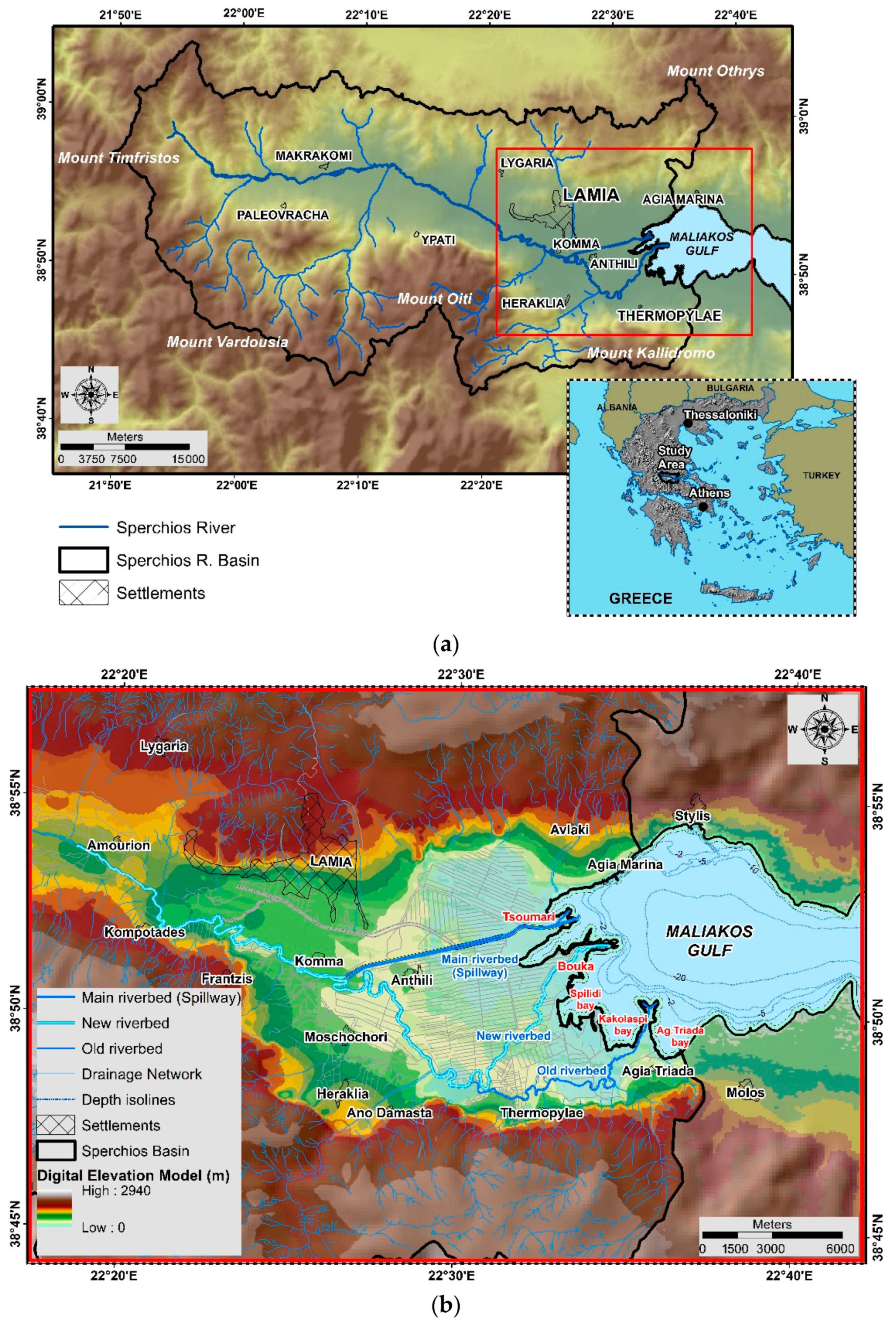
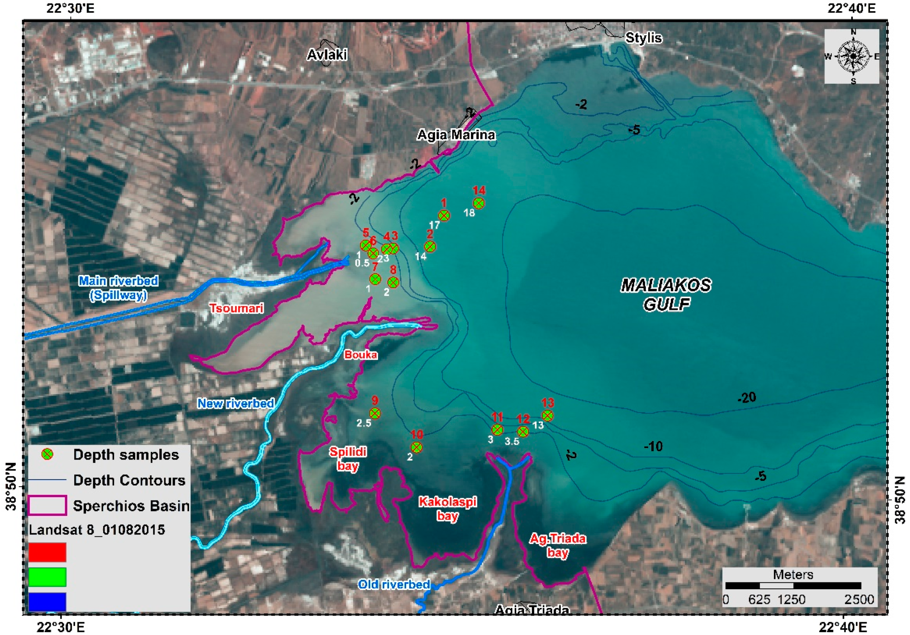
2. Study Area
3. Materials and Methods
3.1. Datasets
3.2. Data Processing
3.2.1. Aerial Photos—Orthophoto Images
3.2.2. Optical Earth Observation Data
3.2.3. Radar Data
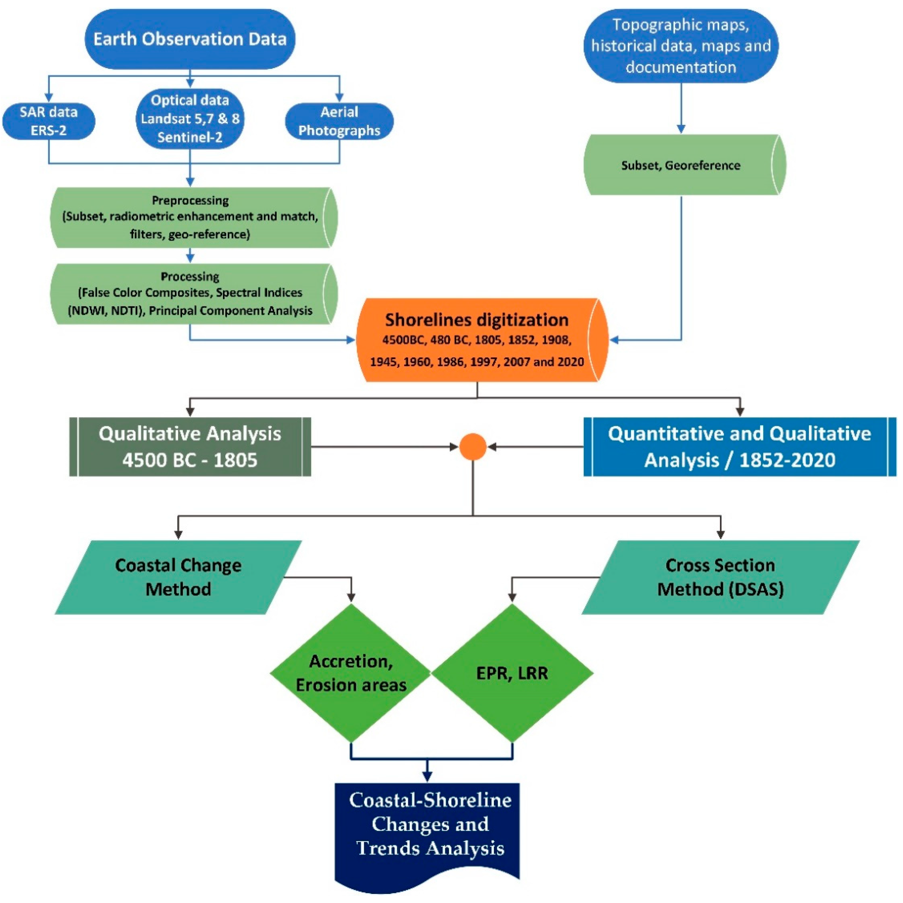
3.3. Methodological Approach for Shoreline Change Detection
3.4. Fieldwork
4. Results and Discussion
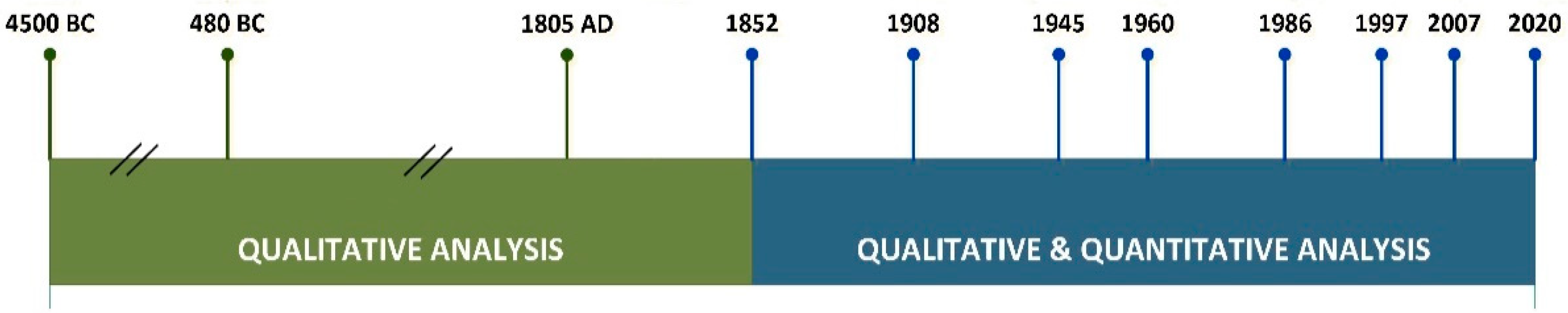
4.1. Overview of Long and Short-Term Coastal Changes
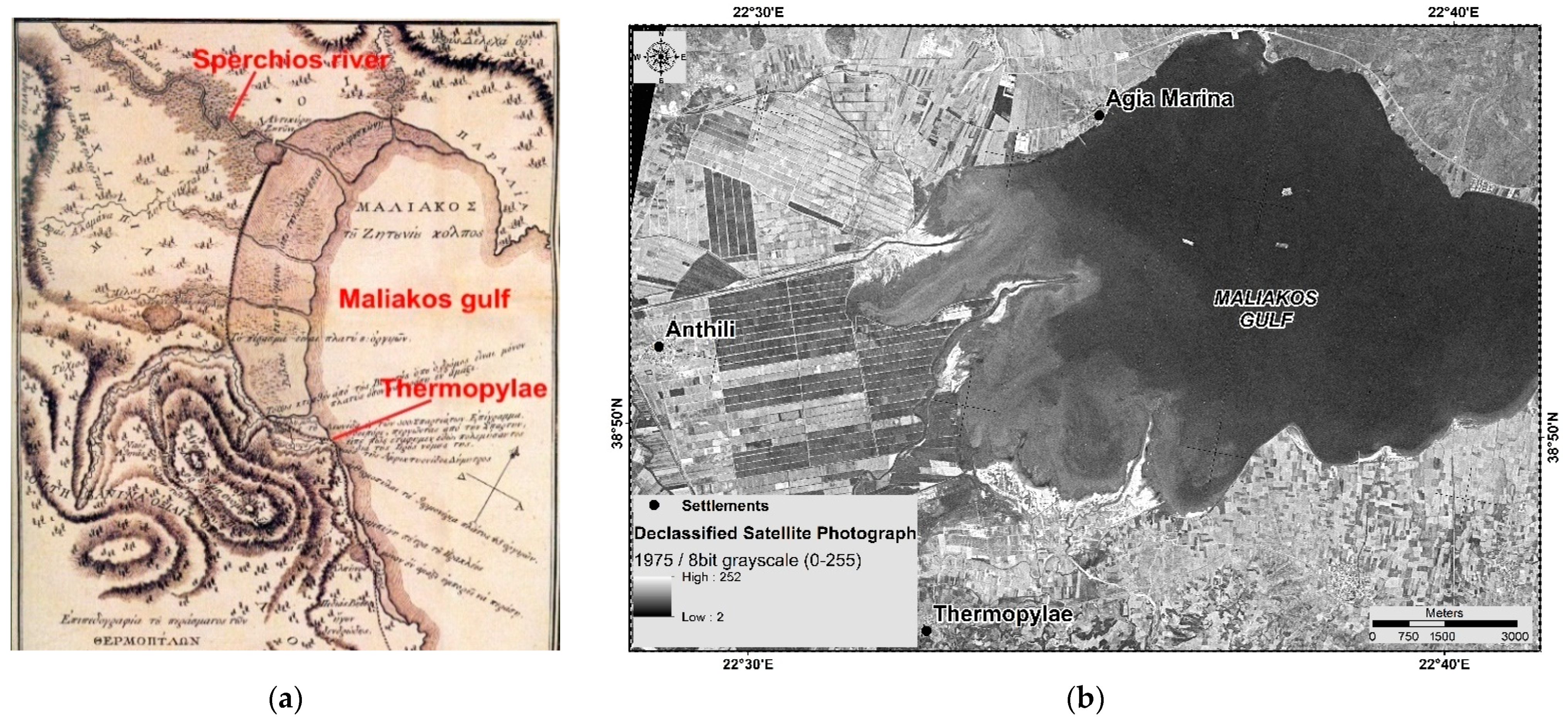
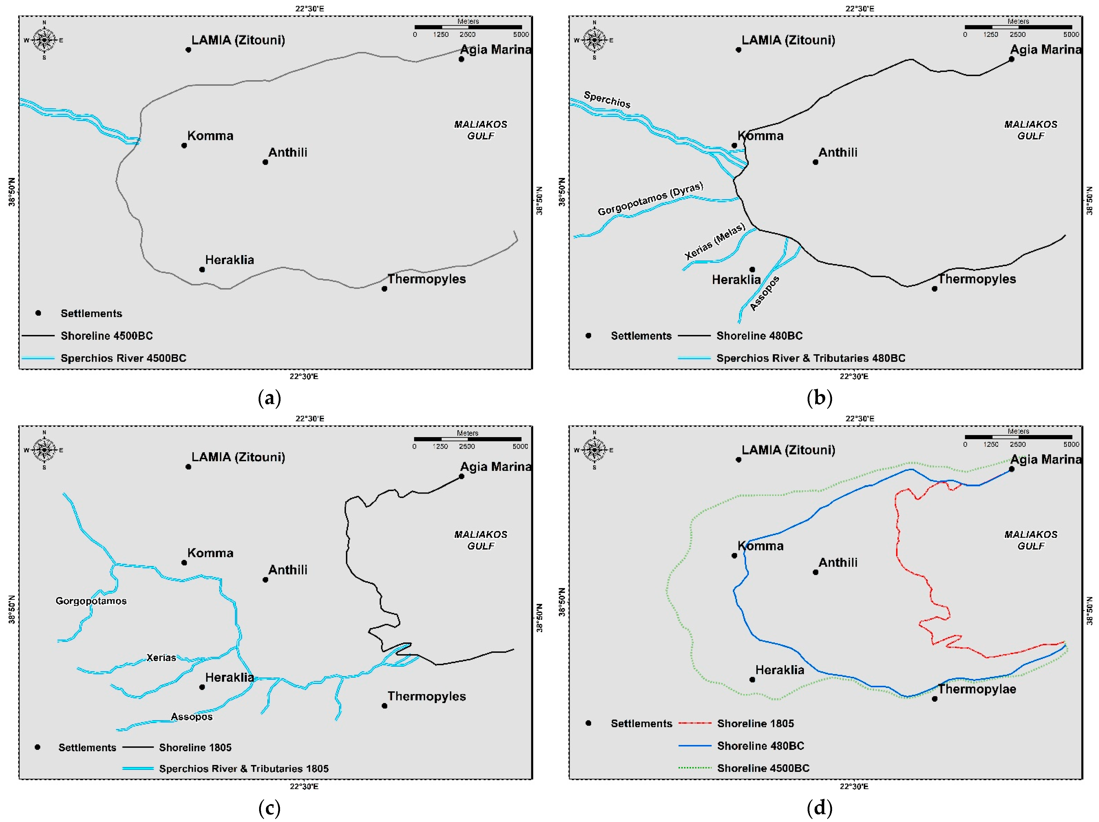
4.2. Historical Evolution of the Area
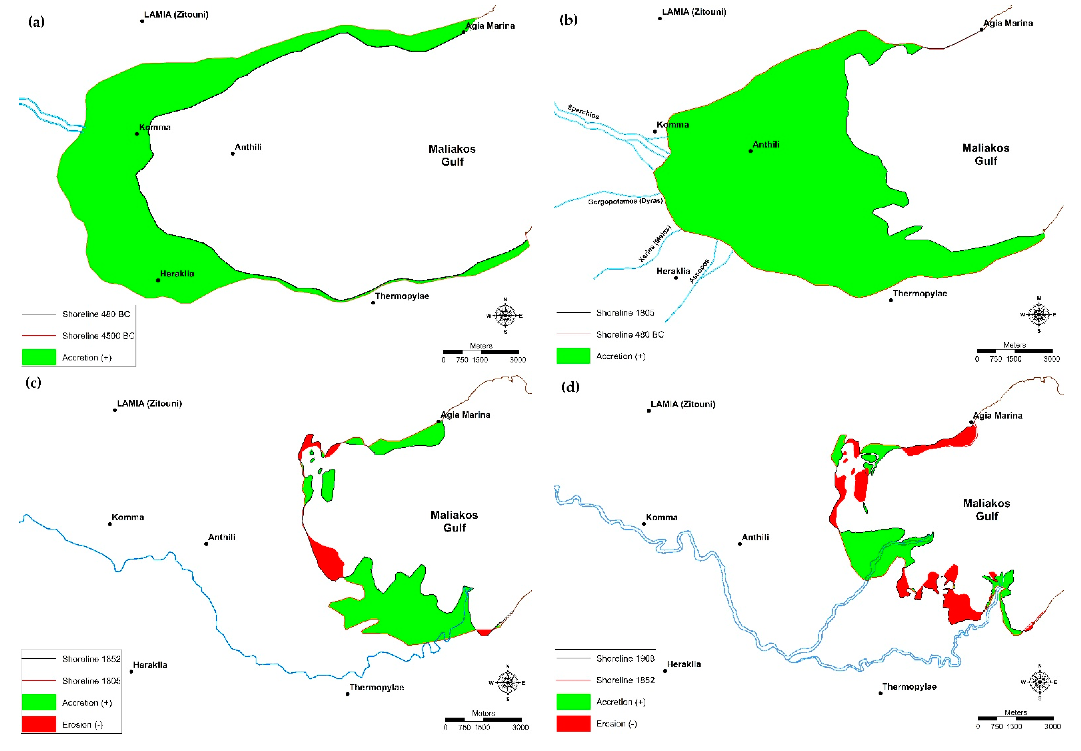
4.3. Coastal Area Status, Shoreline Position, and Drainage Network Development from 4500 BC to 1805
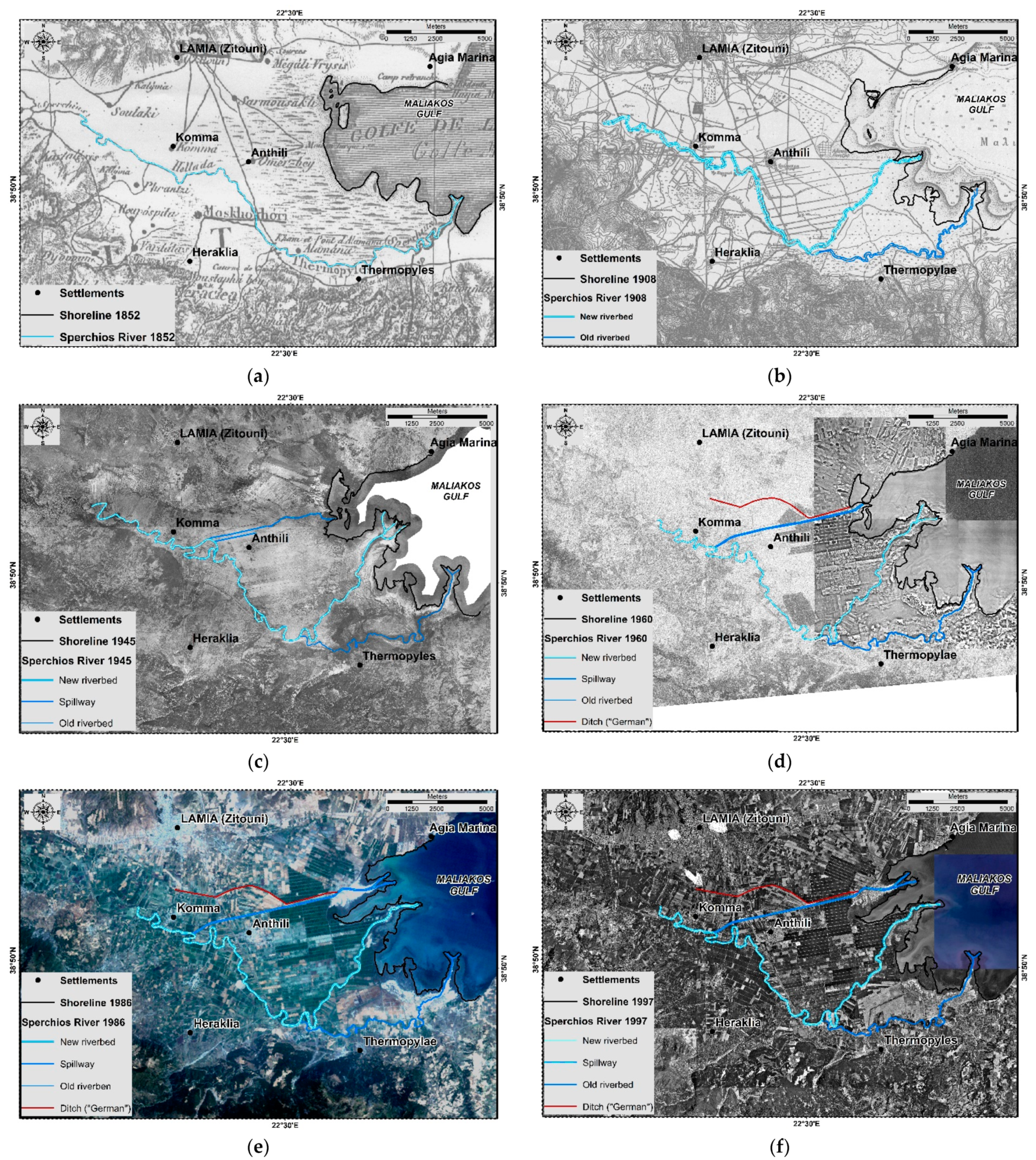
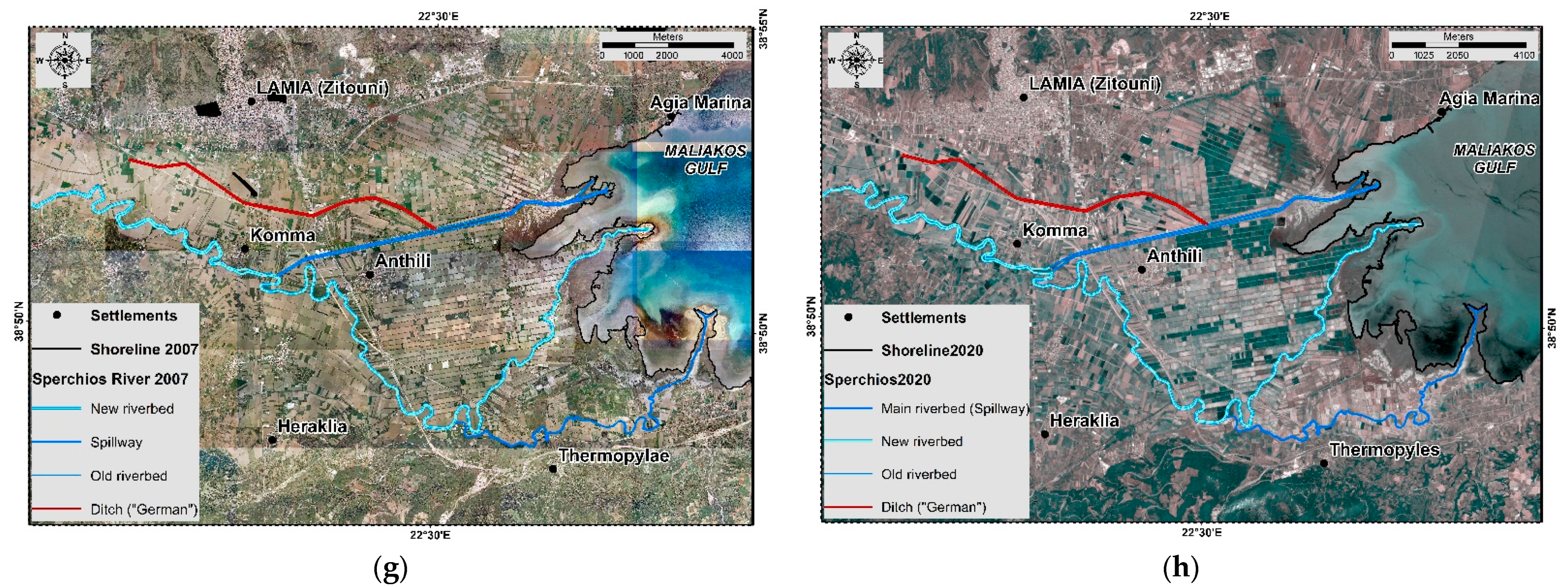
4.4. Coastal Area Status, Shoreline Position, and Drainage Network Development from 1852 to 2020
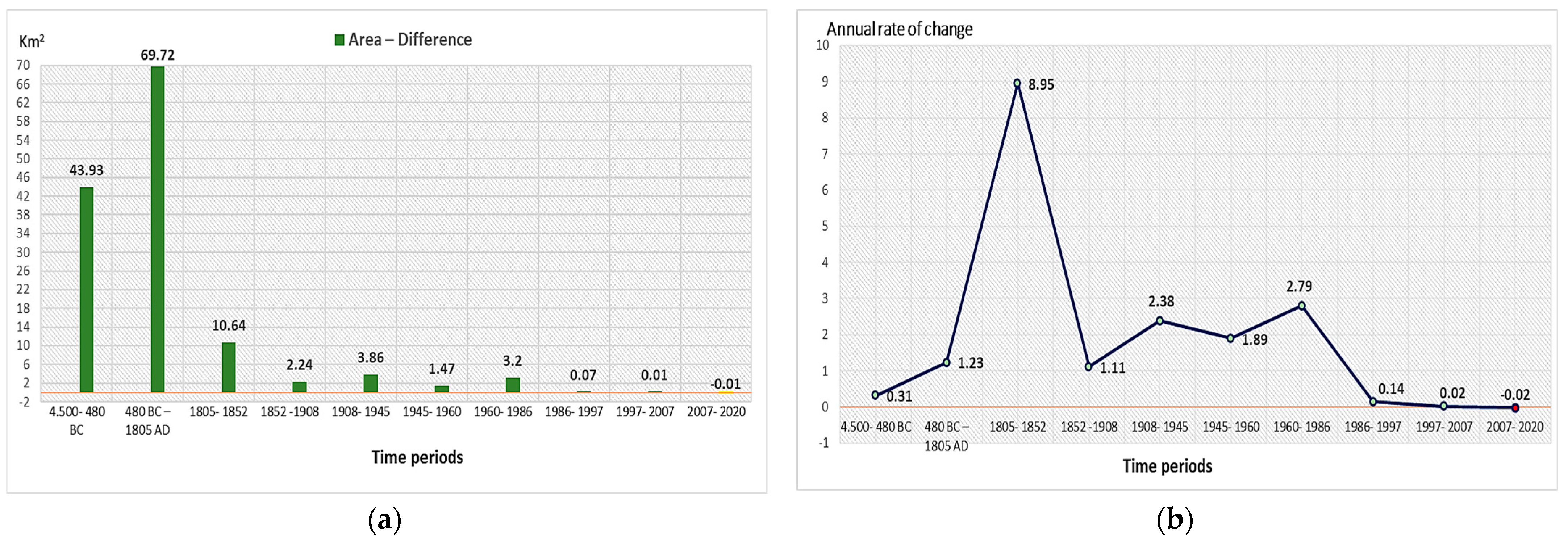
4.5. Coastal Changes Rates and Qualitative Analysis Results from 4500 BC to 1805
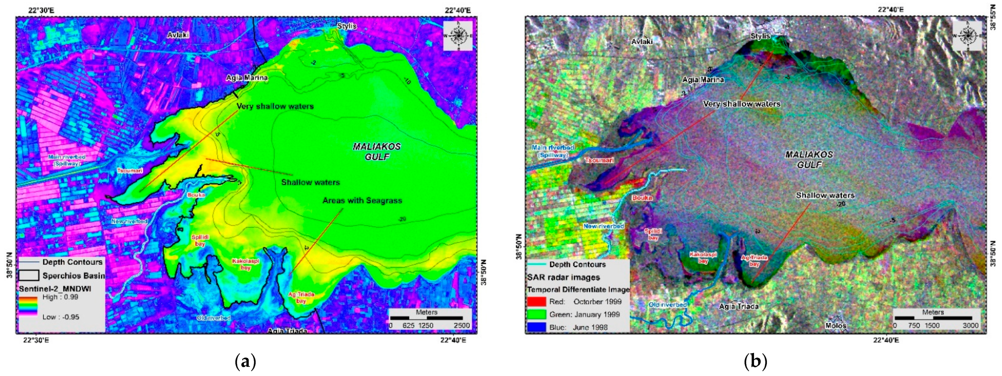
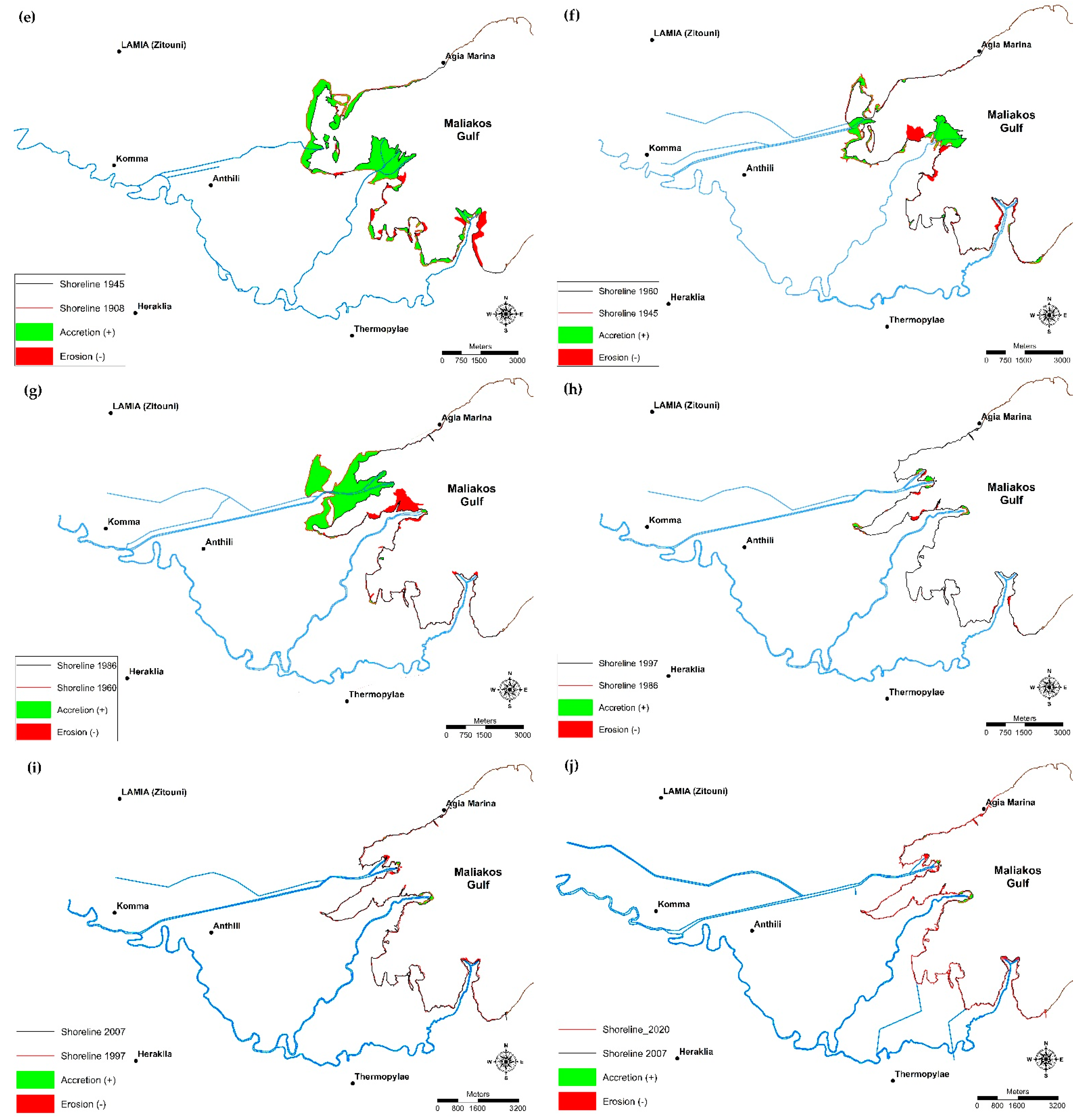
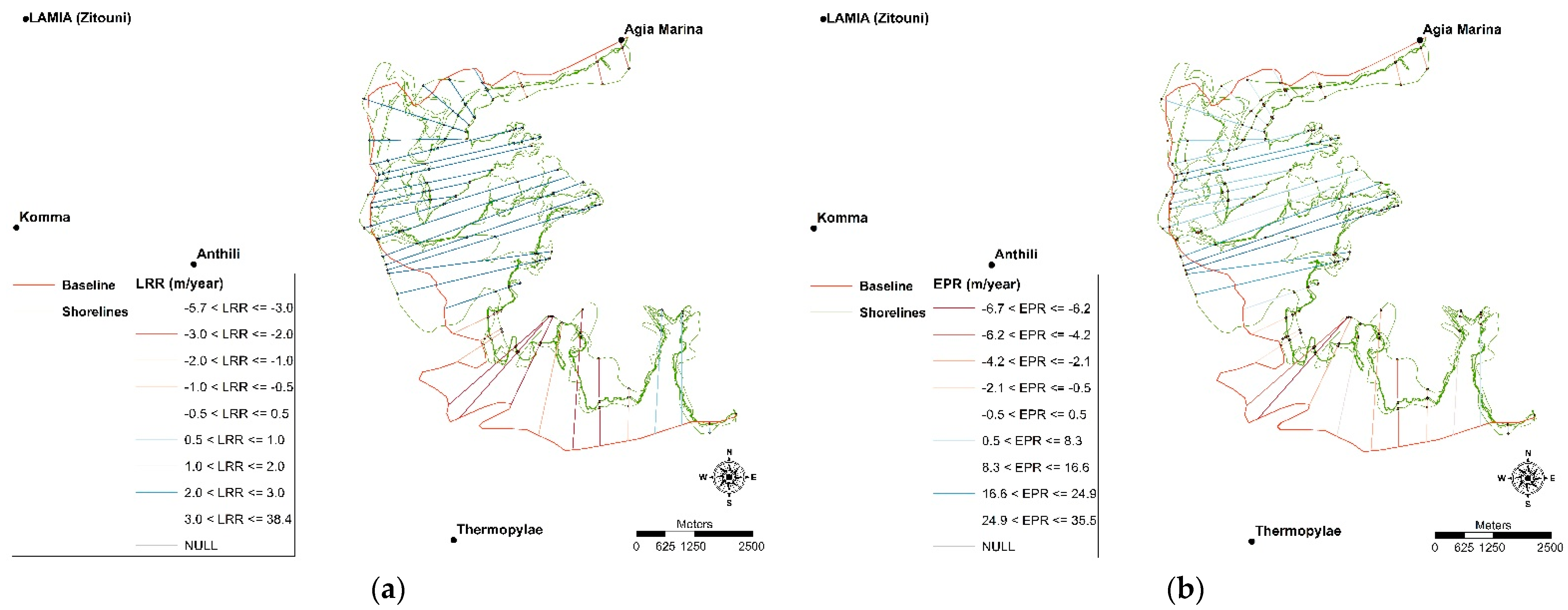
4.6. Coastal Changes Rates and Quantitative-Qualitative Analysis Results from 1852 to 2020
5. Conclusions
Funding
Institutional Review Board Statement
Informed Consent Statement
Data Availability Statement
Conflicts of Interest
References
- Jiang, D.; Hao, M.; Fu, J. Monitoring the coastal environment using remote sensing and GIS techniques. In Applied Studies of Coastal and Marine Environments; InTech: Vienna, Austria, 2016. [Google Scholar]
- Cracknell, A.P. Remote sensing techniques in estuaries and coastal zones—An update. Int. J. Remote Sens. 1999, 20, 485–496. [Google Scholar] [CrossRef]
- Evelpidou, N.; Poulos, S.E.; Vassilopoulos, A. Paros Island (Cyclades, Aegean Sea) Coastal zone: Natural processes and dynamics. In Coastal and Marine Geospatial Technologies; Springer: Berlin/Heidelberg, Germany, 2010; Volume 13, pp. 285–296. [Google Scholar] [CrossRef]
- Marfai, M.A.; Almohammad, H.; Dey, S.; Susanto, B.; King, L. Coastal dynamic and shoreline mapping: Multi-sources spatial data analysis in Semarang Indonesia. Environ. Monit. Assess. 2008, 142, 297–308. [Google Scholar] [CrossRef]
- Kourosh Niya, A.; Alesheikh, A.A.; Soltanpor, M.; Kheirkhahzarkesh, M.M. Shoreline change mapping using remote sensing and GIS case study: Bushehr Province. Int. J. Remote Sens. Appl. 2013, 3, 102–107. [Google Scholar]
- Turner, R.K.; Subak, S.; Adger, W.N. Pressures, trends, and impacts in coastal zones: Interactions between socioeconomic and natural systems. Environ. Manag. 1996, 20, 159–173. [Google Scholar] [CrossRef]
- Mills, J.P.; Buckley, S.J.; Mitchell, H.L.; Clarke, P.J.; Edwards, S.J. A geomatics data integration technique for coastal change monitoring. Earth Surf. Process. Landf. 2005, 30, 651–664. [Google Scholar] [CrossRef]
- Doukakis, E. Evaluation of shoreline change rate methods using forecasting and hindcasting. In Proceedings of the 2nd International Conference on Environmental Research and Assessment, Bucharest, Romania, 5–8 October 2006; University of Bucharest, Centre for Environmental Research and Impact Studies: Bucharest, Romania, 2006; pp. 196–207. [Google Scholar]
- Darwish, K.; Smith, S.E.; Torab, M.; Monsef, H.; Hussein, O. Geomorphological changes along the nile delta coastline between 1945 and 2015 detected using satellite remote sensing and GIS. J. Coast. Res. 2017, 33, 786–794. [Google Scholar] [CrossRef]
- Poulos, S.E.; Collins, M.B.; Shaw, H.F. Deltaic sedimentation, including clay mineral deposition patterns, associated with small mountainous rivers and shallow marine embayments of Greece (SE Alpine Europe). J. Coast. Res. 1996, 12, 940–952. [Google Scholar]
- Davis, R.A. Evolution of coastal landforms. In Treatise on Geomorphology; Elsevier Inc.: Amsterdam, The Netherlands, 2013; Volume 10, pp. 417–448. ISBN 9780080885223. [Google Scholar]
- Stǎnicǎ, A.; Panin, N. Present evolution and future predictions for the deltaic coastal zone between the Sulina and Sf. Gheorghe Danube river mouths (Romania). Geomorphology 2009, 107, 41–46. [Google Scholar] [CrossRef]
- Jabaloy-Sánchez, A.; Lobo, F.J.; Azor, A.; Martín-Rosales, W.; Pérez-Peña, J.V.; Bárcenas, P.; Macías, J.; Fernández-Salas, L.M.; Vázquez-Vílchez, M. Six thousand years of coastline evolution in the Guadalfeo deltaic system (southern Iberian Peninsula). Geomorphology 2014, 206, 374–391. [Google Scholar] [CrossRef]
- Blanco-Chao, R.; Costa-Casais, M.; Cajade-Pascual, D.; Gómez-Rey, G. Coastal retreat and sedimentation during the last 3000 years. Atlantic coast of NW Spain. J. Mar. Sci. Eng. 2019, 7, 331. [Google Scholar] [CrossRef] [Green Version]
- Gharbia, R.; Hassanien, A.E.; El-Baz, A.H.; Elhoseny, M.; Gunasekaran, M. Multi-spectral and panchromatic image fusion approach using stationary wavelet transform and swarm flower pollination optimization for remote sensing applications. Futur. Gener. Comput. Syst. 2018, 88, 501–511. [Google Scholar] [CrossRef]
- Aquino da Silva, A.G.; Stattegger, K.; Vital, H.; Schwarzer, K. Coastline change and offshore suspended sediment dynamics in a naturally developing delta (Parnaíba Delta, NE Brazil). Mar. Geol. 2019, 410, 1–15. [Google Scholar] [CrossRef]
- Poulos, S.E.; Chronis, G.T. Coastline changes in relation to longshore sediment transport and human impact, along the shoreline of kato achaia (NW Peloponnese, Greece). Mediterr. Mar. Sci. 2001, 2, 5–13. [Google Scholar] [CrossRef]
- Nordstrom, K.F. Developed Coasts. In Treatise on Geomorphology; Elsevier Inc.: Amsterdam, The Netherlands, 2013; Volume 10, pp. 392–416. ISBN 9780080885223. [Google Scholar]
- Hood, W.G. Delta distributary dynamics in the Skagit River Delta (Washington, USA): Extending, testing, and applying avulsion theory in a tidal system. Geomorphology 2010, 123, 154–164. [Google Scholar] [CrossRef]
- Syvitski, J.P.M.; Saito, Y. Morphodynamics of deltas under the influence of humans. Glob. Planet. Chang. 2007, 57, 261–282. [Google Scholar] [CrossRef]
- Brown, S.; Nicholls, R.J. Subsidence and human influences in mega deltas: The case of the Ganges-Brahmaputra-Meghna. Sci. Total Environ. 2015, 527–528, 362–374. [Google Scholar] [CrossRef] [Green Version]
- Ford, M. Shoreline changes interpreted from multi-temporal aerial photographs and high resolution satellite images: Wotje Atoll, Marshall Islands. Remote Sens. Environ. 2013, 135, 130–140. [Google Scholar] [CrossRef]
- Niang, A.J. Monitoring long-term shoreline changes along Yanbu, Kingdom of Saudi Arabia using remote sensing and GIS techniques. J. Taibah. Univ. Sci. 2020, 14, 762–776. [Google Scholar] [CrossRef]
- Klemas, V. Airborne remote sensing of coastal features and processes: An overview. J. Coast. Res. 2013, 287, 239–255. [Google Scholar] [CrossRef]
- Shoshany, M.; Degani, A. Shoreline detection by digital image processing of aerial photography. J. Coast. Res. 1992, 8, 29–34. [Google Scholar]
- Smith, G.L.; Zartllo, G.A. Calculating long-term shoreline recession rates using aerial photographic and beach profiling techniques. J. Coast. Res. 1990, 6, 111–120. [Google Scholar]
- Kankara, R.S.; Selvan, S.C.; Markose, V.J.; Rajan, B.; Arockiaraj, S. Estimation of long and short term shoreline changes along Andhra Pradesh coast using remote sensing and GIS techniques. Procedia Eng. 2015, 116, 855–862. [Google Scholar] [CrossRef] [Green Version]
- Psomiadis, E.; Parcharidis, I.; Poulos, S.; Stamatis, G.; Migiros, G.; Pavlopoulos, A. Earth observation data in seasonal and long term coastline changes monitoring the case of Sperchios river delta (central Greece). Z. Fur Geomorphol. Suppl. 2005, 137, 159–175. [Google Scholar]
- Efthimiou, N.; Psomiadis, E.; Panagos, P. Fire severity and soil erosion susceptibility mapping using multi-temporal Earth Observation data: The case of Mati fatal wildfire in Eastern Attica, Greece. Catena 2020, 187, 104320. [Google Scholar] [CrossRef] [PubMed]
- Irons, J.R.; Dwyer, J.L.; Barsi, J.A. The next Landsat satellite: The landsat data continuity mission. Remote Sens. Environ. 2012, 122, 11–21. [Google Scholar] [CrossRef] [Green Version]
- Drusch, M.; Del Bello, U.; Carlier, S.; Colin, O.; Fernandez, V.; Gascon, F.; Hoersch, B.; Isola, C.; Laberinti, P.; Martimort, P.; et al. Sentinel-2: ESA’s optical high-resolution mission for GMES operational services. Remote Sens. Environ. 2012, 120, 25–36. [Google Scholar] [CrossRef]
- Bergsma, E.W.J.; Almar, R. Coastal coverage of ESA’ Sentinel 2 mission. Adv. Space Res. 2020, 65, 2636–2644. [Google Scholar] [CrossRef]
- Ekercin, S. Coastline change assessment at the aegean sea coasts in Turkey using multitemporal landsat imagery. J. Coast. Res. 2007, 233, 691–698. [Google Scholar] [CrossRef]
- Choung, Y.J.; Jo, M.H. Shoreline change assessment for various types of coasts using multi-temporal Landsat imagery of the east coast of South Korea. Remote Sens. Lett. 2016, 7, 91–100. [Google Scholar] [CrossRef]
- Natarajan, L.; Sivagnanam, N.; Usha, T.; Chokkalingam, L.; Sundar, S.; Gowrappan, M.; Roy, P.D. Shoreline changes over last five decades and predictions for 2030 and 2040: A case study from Cuddalore, southeast coast of India. Earth Sci. Inform. 2021, 14, 1315–1325. [Google Scholar] [CrossRef]
- Ouma, Y.O.; Tateishi, R. A water index for rapid mapping of shoreline changes of five East African Rift Valley lakes: An empirical analysis using Landsat TM and ETM+ data. Int. J. Remote Sens. 2006, 27, 3153–3181. [Google Scholar] [CrossRef]
- Psomiadis, E.; Migiros, G.; Parcharidis, I.; Poulos, S. Short period change detection of sperchios lower delta area using space radar images. Bull. Geol. Soc. Greece 2004, 36, 919. [Google Scholar] [CrossRef] [Green Version]
- Pleskachevsky, A.; Lehner, S.; Heege, T.; Mott, C. Synergy and fusion of optical and synthetic aperture radar satellite data for underwater topography estimation in coastal areas. Ocean. Dyn. 2011, 6, 2099–2120. [Google Scholar] [CrossRef] [Green Version]
- Nandi, S.; Ghosh, M.; Kundu, A.; Dutta, D.; Baksi, M. Shoreline shifting and its prediction using remote sensing and GIS techniques: A case study of Sagar Island, West Bengal (India). J. Coast. Conserv. 2016, 20, 61–80. [Google Scholar] [CrossRef]
- Rodríguez, I.; Montoya, I.; Sánchez, M.J.; Carreño, F. Geographic information systems applied to integrated coastal zone management. Geomorphology 2009, 107, 100–105. [Google Scholar] [CrossRef]
- Petropoulos, G.P.; Kalivas, D.P.; Griffiths, H.M.; Dimou, P.P. Remote sensing and GIS analysis for mapping spatio-temporal changes of erosion and deposition of two Mediterranean river deltas: The case of the Axios and Aliakmonas rivers, Greece. Int. J. Appl. Earth Obs. Geoinf. 2015, 35, 217–228. [Google Scholar] [CrossRef]
- Kraft, J.C.; Rapp, G.; Szemler, G.J.; Tziavos, C.; Kase, E.W. The pass at thermopylae, Greece. J. F. Archaeol. 1987, 14, 181–198. [Google Scholar] [CrossRef]
- Psomiadis, E. Research of Geomorphological and Environmental Changes in the Sperchios’ River Basin Utilizing New Technologies. Ph.D. Thesis, Agricultural University of Athens, Athens, Greece, 2010. (In Greek). [Google Scholar]
- Zamani, A.; Maroukian, H. A morphological study of an old delta of the Sperchios River. In Proceedings of the 6th Colloquium on the Geology of the Aegean Region; Athens, Greece, Kallergis, G., Ed.; Institute of Geological and Mining Research: Athens, Greece, 1977; pp. 261–282. [Google Scholar]
- Shetty, A.; Jayappa, K.S.; Mitra, D. Shoreline change analysis of mangalore coast and morphometric analysis of netravathi-gurupur and mulky-pavanje Spits. Aquat. Procedia 2015, 4, 182–189. [Google Scholar] [CrossRef]
- Karastathis, V.K.; Ganas, A.; Makris, J.; Papoulia, J.; Dafnis, P.; Gerolymatou, E.; Drakatos, G. The application of shallow seismic techniques in the study of active faults: The Atalanti normal fault, central Greece. J. Appl. Geophys. 2007, 62, 215–233. [Google Scholar] [CrossRef]
- Ganas, A.; Roberts, G.P.; Memou, T. Segment boundaries, the 1894 ruptures and strain patterns along the Atalanti fault, central Greece. J. Geodyn. 1998, 26, 461–486. [Google Scholar] [CrossRef]
- Psomiadis, E.; Charizopoulos, N.; Soulis, K.X.; Efthimiou, N. Investigating the correlation of tectonic and morphometric characteristics with the hydrological response in a Greek river catchment using earth observation and geospatial analysis techniques. Geosciences 2020, 10, 377. [Google Scholar] [CrossRef]
- Mariolakos, I. Thoughts and views on certain issues of geology and tectonics of the peloponnese. Ann Geol Pays Hell. 1976, 27, 215–313. [Google Scholar]
- Maroukian, H.; Lagios, E. Neotectonic movements in the Sperkhios River basin, Central Greece. Z. Für Geomorphologie. Suppl. 1987, 63, 133–140. [Google Scholar]
- Therianos, A.D. The geographical distribution of river water supply in Greece (In Greek). Bull. Geol. Soc. Greece 1974, 11, 28–58. [Google Scholar]
- Poulos, S.; Leontaris, S.; Collins, M.B. Sedimentological and clay mineralogical investigations in Maliakos Gulf, eastern Greece. Boll. Geofis. Teor. Appl. 1997, 38, 267–279. [Google Scholar]
- Mariolakos, I.; Bantekas, J.; Markatselis, E.; Papageorgiou, M.; Boukouvalas, A.; Stavropoulos, G. National thematic network of environmental education, Geoenvironmental-Geomythological paths. In Proceedings of the 4th Conference of the Panhellenic Association of Teachers for Environmental Education (PEEKPE), Nafplio, Greece, 12–14 December 2008; p. 14. [Google Scholar]
- Herodotus. Herodotus History,"Hροδότου Aλικαρνησσέος Ιστορίης Aποδέξις"—The World of Herodotus; A High School Book; Textbook Publishing Organization: Athens, Greece, 1989. [Google Scholar]
- Strabo. The Geography of Strabo, Literally Translated, with Notes, in Three Volumes; George Bell & Sons: London, UK, 1903. [Google Scholar]
- Feraios, R. The Charta of Greece. 1797. Available online: https://upload.wikimedia.org/wikipedia/commons/thumb/f/f4/Charta_Riga_1797_Sheet_5.pdf/page1-2079px-Chara_of_Riga-_1797_-_Sheet_5.pdf.jpg (accessed on 10 September 2021).
- Davanelos, N.T.; Stavropoulos, G.P. Lamia—With the Stylus of the Travellers (1159–1940); Oionos: Lamia, Greece, 2005. [Google Scholar]
- Psomiadis, E.; Soulis, K.; Zoka, M.; Dercas, N. Synergistic approach of remote sensing and GIS techniques for flash-flood monitoring and damage assessment in thessaly plain area, Greece. Water 2019, 11, 448. [Google Scholar] [CrossRef] [Green Version]
- Psomiadis, E.; Diakakis, M.; Soulis, K.X. Combining SAR and optical earth observation with hydraulic simulation for flood mapping and impact assessment. Remote Sens. 2020, 12, 3980. [Google Scholar] [CrossRef]
- Psomiadis, E.; Soulis, K.X.; Efthimiou, N. Using SCS-CN and earth observation for the comparative assessment of the hydrological effect of gradual and abrupt spatiotemporal land cover changes. Water 2020, 12, 1386. [Google Scholar] [CrossRef]
- Robinove, C.J. Computation with physical values from Landsat digital data. Photogramm. Eng. Remote Sens. 1982, 48, 781–784. [Google Scholar]
- Chavez, P.S. An improved dark-object subtraction technique for atmospheric scattering correction of multispectral data. Remote Sens. Environ. 1988, 24, 459–479. [Google Scholar] [CrossRef]
- Atmospheric Correction. Available online: https://www.l3harrisgeospatial.com/docs/atmosphericcorrection.html#Using (accessed on 20 September 2021).
- Jangir, B.; Satyanarayana, A.N.V.; Swati, S.; Jayaram, C.; Chowdary, V.M.; Dadhwal, V.K. Delineation of spatio-temporal changes of shoreline and geomorphological features of Odisha coast of India using remote sensing and GIS techniques. Nat. Hazards 2016, 82, 1437–1455. [Google Scholar] [CrossRef]
- Xu, H. Modification of normalised difference water index (NDWI) to enhance open water features in remotely sensed imagery. Int. J. Remote Sens. 2006, 27, 3025–3033. [Google Scholar] [CrossRef]
- McFeeters, S.K. The use of the Normalized Difference Water Index (NDWI) in the delineation of open water features. Int. J. Remote Sens. 1996, 17, 1425–1432. [Google Scholar] [CrossRef]
- Lacaux, J.P.; Tourre, Y.M.; Vignolles, C.; Ndione, J.A.; Lafaye, M. Classification of ponds from high-spatial resolution remote sensing: Application to Rift Valley Fever epidemics in Senegal. Remote Sens. Environ. 2007, 106, 66–74. [Google Scholar] [CrossRef]
- Psomiadis, E. Flash flood area mapping utilising SENTINEL-1 radar data. In Earth Resources and Environmental Remote Sensing/GIS Applications VII; SPIE: Bellingham, WA, USA, 2016; Volume 10005, p. 100051G. [Google Scholar]
- Doukakis, E. Development of the Coastal Zone. Master’s Thesis, National Technical University of Athens, Athens, Greece, 2005. (In Greek). [Google Scholar]
- United States Geological Survey (USGS) Digital Shoreline Analysis System (DSAS). Available online: https://www.usgs.gov/centers/whcmsc/science/digital-shoreline-analysis-system-dsas?qt-science_center_objects=0#qt-science_center_objects (accessed on 7 September 2021).
- Thieler, E.R.; Himmelstoss, E.A.; Zichichi, J.L.; Ergul, A. The Digital Shoreline Analysis System (DSAS) Version 4.0—An ArcGIS Extension for Calculating Shoreline Change; U.S. Geological Survey: Reston, VA, USA, 2009.
- Aedla, R.; Dwarakish, G.S.; Reddy, D.V. Automatic shoreline detection and change detection analysis of netravati-gurpurrivermouth using histogram equalization and adaptive thresholding techniques. Aquat. Procedia 2015, 4, 563–570. [Google Scholar] [CrossRef]
- Salghuna, N.N.; Bharathvaj, S.A. Shoreline change analysis for northern part of the Coromandel coast. Aquat. Procedia 2015, 4, 317–324. [Google Scholar] [CrossRef]
- Mentzafou, A.; Markogianni, V.; Papadopoulos, A.; Pavlidou, A.; Tziavos, C.; Dimitriou, E. The impacts of anthropogenic and climatic factors on the interaction of Spercheios River and Maliakos Gulf, the Aegean Sea. In The Handbook of Environmental Chemistry; Springer: Berlin/Heidelberg, Germany, 2020. [Google Scholar]
- Tselika, V. Form and Development of Prehistoric Settlements in Greece: Spatial Planning and Settlement Patterning. Ph.D. Thesis, Aristotle University of Thessaloniki, Thessaloniki, Greece, 2006. (In Greek). [Google Scholar]
- Tziavos, C. Sedimentology, Ecology and Paleogeography of the Sperchios Valley and Maliakos Gulf, Greece. Ph.D. Thesis, University of Delaware, Newark, DE, USA, 1977. [Google Scholar]
- Kraft, J.C.; Rapp, R.G. Geological reconstruction of ancient coastal landforms in Greece with predictions of future coastal changes. Eng. Geol. Environ. 1988, VII, 1545–1556. [Google Scholar]
- Leake, W.M. Travels in Northern Greece; Gilbert & Rivington: London, UK, 1835; Volume 2. [Google Scholar]
- Pausanias. Description of Greece, with an English Translation by W.H.S. Jones; Litt, D., Ormerod, H.A., William, H., Eds.; Harvard University Press: London, UK, 1918. [Google Scholar]
- Lambeck, K. Late Pleistocene and Holocene sea-level change in Greece and south-western Turkey: A separation of eustatic, isostatic and tectonic contributions. Geophys. J. Int. 1995, 122, 1022–1044. [Google Scholar] [CrossRef] [Green Version]
- Mariolakos, I.D. The geoenvironmental dimension of Greek mythology. Bull. Geol. Soc. Greece 2002, 34, 2065. [Google Scholar] [CrossRef]
- Psomiadis, E.; Charizopoulos, N.; Efthimiou, N.; Soulis, K.X.; Charalampopoulos, I. Earth observation and GIS-based analysis for landslide susceptibility and risk assessment. ISPRS Int. J. Geo-Inf. 2020, 9, 552. [Google Scholar] [CrossRef]
- Vouvalidis, K.; Syrides, G.; Pavlopoulos, K.; Pechlivanidou, S.; Tsourlos, P.; Papakonstantinou, M.F. Palaeogeographical reconstruction of the battle terrain in Ancient Thermopylae, Greece. In Geodinamica Acta; Taylor & Francis Group: Oxfordshire, UK, 2010; Volume 23, pp. 241–253. [Google Scholar]
- Davis, W.M. Geographical Essays; Dover Publications: Mineola, NY, USA, 1954. [Google Scholar]
- Gawthorpe, R.L.; Leeder, M.R. Tectono-sedimentary evolution of active extensional basins. Basin Res. 2000, 12, 195–218. [Google Scholar] [CrossRef]
- Eliet, P.P.; Gawthorpe, R.L. Drainage development and sediment supply within rifts, examples from the Sperchios Basin, central Greece. J.-Geol. Soc. 1995, 152, 883–893. [Google Scholar] [CrossRef]
- Doukakis, E. Identifying coastal vulnerability due to climate changes. J. Mar. Environ. Eng. 2005, 8, 155–160. [Google Scholar]
- Wace, A.J.B.; Thomson, M.S. Prehistoric Thessaly; Cambridge University Press (CUP): Cambridge, UK, 1912. [Google Scholar]
- Platis, G.; Mountouris, N. Lamia: Historical and Social Research, 1st ed.; Municipality of Lamia: Lamia, Greece, 1973. [Google Scholar]
- Kapnias, D. The Valley of Sperchios in Spacetime; Stamoulis Publications: Athens, Greece, 1999; ISBN 9789609133807. [Google Scholar]
- Eratosthenes and the Mystery of the Stades—How Long Is a Stade? | Mathematical Association of America. Available online: https://www.maa.org/press/periodicals/convergence/eratosthenes-and-the-mystery-of-the-stades-how-long-is-a-stade (accessed on 16 September 2021).
- Liddell, H.G.; Scott, R. A Greek-English Lexicon, στάδιον. Available online: http://www.perseus.tufts.edu/hopper/text?doc=Perseus:text:1999.04.0057:entry=sta/dion (accessed on 16 September 2021).
- Dakoronia, F. Achilles in the valley of Sperchios. Archaeology 1990, 34, 40–43. [Google Scholar]
- Pantazis, P. The battle of Sperchios between Byzantine and Bulgarian troops 997 AD. In Proceedings of the 3rd Conference of Fthiotian History (History-Archeology-Folklore), Lamia, Greece, 3–6 June 2007. [Google Scholar]
- Candelli, G. “Macedonia Epiro Livadia Albania et Ianna”. Map of the regions of Macedonia, Epirus, Livadia, Albania and Ioannina. Black and white copper engraving with colouring, Giacomo Cantelli da Vignola, Gio. Giacomo de Rossi, Fran.us Donia, Rome. 1684. Available online: https://www.nhmuseum.gr/en/departments/into-the-museum-s-collection/item/9546-macedoniaepirolivadiaalbaniaetiannamapoftheregionsofmacedo (accessed on 20 September 2021).
- Lucas, P. Voyage du Sieur Paul Lucas, Fait par Ordre du Roi dans la Grece, l’Asie...—Paul Lucas—Βιβλία Google. Available online: https://books.google.gr/books?hl=el&lr=&id=YRo-AAAAcAAJ&oi=fnd&pg=PP33&ots=X7CbWz13OO&sig=JE0Iy4bdFCsp3o43mnSgBU5kRoQ&redir_esc=y#v=onepage&q&f=false (accessed on 20 September 2021).
- Vortselas, J. Fthiotis, to the South of Othrys Mountain, a Flowering of Historical and Geographical News from the Most Ancient Times to Nowadays, 2nd ed.; Papaspyrou Publ.: Athens, Greece, 1907. [Google Scholar]
- Pococke, R. A Description of the East and Some Other Countries—Richard Pococke—Βιβλία Google. Available online: https://books.google.gr/books?hl=el&lr=&id=aiAdpfVZH9gC&oi=fnd&pg=PP23&ots=x4dDwcDAzo&sig=FKptZDeoT2BmBsrUg0LHHNtUi7A&redir_esc=y#v=onepage&q&f=false (accessed on 20 September 2021).
- Papazachos, B.C.; Papazachou, C.C. The Earthquakes of Greece; Ziti Publshing: Thessaloniki, Greece, 1989. [Google Scholar]
- Ministry of Environment and Energy. Floods Archive. Available online: https://ypen.gov.gr/perivallon/ydatikoi-poroi/plimmyres/ (accessed on 4 January 2022).
- Sigalos, G.; Alexouli-Livaditi, A. Investigation of the evolution of a coastline over time-prediction of future applications. The case of Maliakos Gulf. Bull. Geol. Soc. Greece 2006, XXXIX, 162–173. [Google Scholar]
- Hammond, N.G.L. The geography of Greece—Alfred philippson: Die griechischen Landschaften. Band I, Teil 1: Thessalien und die Spercheios-Senke. Pp. 308: 4 maps. Frankfurt-am-Main: Klostermann, 1950. Paper, DM. 20. Classical Rev. 1951, 1, 221–223. [Google Scholar] [CrossRef]
- Mentzafou, A.; Wagner, S.; Dimitriou, E. Historical trends and the long-term changes of the hydrological cycle components in a Mediterranean river basin. Sci. Total Environ. 2018, 636, 558–568. [Google Scholar] [CrossRef] [PubMed]
- Pantosti, D.; De Martini, P.M.; Papanastassiou, D.; Palyvos, N.; Lemeille, F.; Stavrakakis, G. Paleoseismological Trenching across the Atalanti Fault (Central Greece): Evidence for the Ancestorsof the 1894. Earthquake during the Middle Age and Roman Times. Bull. Seismol. Soc. Am. 2004, 94, 531–549. [Google Scholar] [CrossRef]
- Albini, P.; Pantosti, D. The 20 and 27 April 1894 (Locris, Central Greece) earthquake sources through coeval records on macroseismic effects. Bull. Seismol. Soc. Am. 2004, 94, 1305–1326. [Google Scholar] [CrossRef]
- Ganas, A.; Sokos, E.; Agalos, A.; Leontakianakos, G.; Pavlides, S. Coulomb stress triggering of earthquakes along the Atalanti Fault, central Greece: Two April 1894 M6+ events and stress change patterns. Tectonophysics 2006, 420, 357–369. [Google Scholar] [CrossRef]
- Ambraseys, N.N.; Jackson, J.A. Faulting associated with historical and recent earthquakes in the Eastern Mediterranean region. Geophys. J. Int. 1998, 133, 390–406. [Google Scholar] [CrossRef] [Green Version]
- Zamani, A.; Maroukian, H. Deltaic sedimentation of the Sperchios River in historical times. Ann. Géologiques Pays. Hellénique 1980, 30, 430–440. [Google Scholar]
- Arapaki, E. Flood Protection Constructions in Sperchios River. Available online: https://docplayer.gr/47681408-Antipliuuyrika-erga-ston-sperheio-potauo.html (accessed on 22 September 2021).
- Mentzafou, A.; Varlas, G.; Dimitriou, E.; Papadopoulos, A.; Pytharoulis, I.; Katsafados, P. Modeling the effects of anthropogenic land cover changes to the main hydrometeorological factors in a Regional Watershed, Central Greece. Climate 2019, 7, 129. [Google Scholar] [CrossRef] [Green Version]
- Soulis, K.X.; Psomiadis, E.; Londra, P.; Skuras, D. A new model-based approach for the evaluation of the net contribution of the European union rural development program to the reduction of water abstractions in agriculture. Sustainability 2020, 12, 7137. [Google Scholar] [CrossRef]
- Pechlivanidou, S.; Vouvalidis, K.; Løvlie, R.; Nesje, A.; Albanakis, K.; Pennos, C.; Syrides, G.; Cowie, P.; Gawthorpe, R. A multi-proxy approach to reconstructing sedimentary environments from the Sperchios delta, Greece. Holocene 2014, 24, 1825–1839. [Google Scholar] [CrossRef]
- Pechlivanidou, S.; Cowie, P.A.; Hannisdal, B.; Whittaker, A.C.; Gawthorpe, R.L.; Pennos, C.; Riiser, O.S. Source-to-sink analysis in an active extensional setting: Holocene erosion and deposition in the Sperchios rift, central Greece. Basin Res. 2018, 30, 522–543. [Google Scholar] [CrossRef] [Green Version]
- Psomiadis, E.; Migiros, G.; Antoniou, V. Geomorphological quantitative analysis of Sperchios River Basin area (Central Greece) utilizing geographical information systems. Bull. Geol. Soc. Greece 2013, 47, 325. [Google Scholar] [CrossRef] [Green Version]
- Dolan, R.; Fenster, M.S.; Holme, S.J. Temporal analysis of shoreline recession and accretion. J. Coast. Res. 1991, 7, 723–744. [Google Scholar]


| Type/Scale | Reference Date | Source | |
|---|---|---|---|
| Qualitative Data | Paleogeographic evolution Map/no scale | 4500 BC | Mariolakos et al. [53] |
| Battle of Thermopylae Map/no scale | 480 BC | Herodotos—History Book [54] | |
| Map of Strabo/no scale | 1st Century | Strabo [55] | |
| Map of Olivier/no scale | 17th Century | Based on the map of B. Du Bocage (17th century) | |
| Charta of Rigas Feraios (Map of Greece)/no scale | 17th Century/480 BC | Web portal [56] | |
| Map of Martin Leake/no scale | 1805 | Zamani and Maroukian [44] | |
| Map of Laurengebrio/no scale | 1825 | Davanellos and Stavropoulos [57] | |
| Quantitative Data | French Geographic Map (Imprime chez Kappelin Quai Voltaire 17 Paris)/1:200,000 | 1852 | Laboratory of Mineralogy and Geology (Agricultural University of Athens) Archive |
| Topographic Map/1:75,000 | 1908 | Hellenic Military Geographical Service | |
| Aerial photographs/1:42,000 | 1945/1960 | Hellenic Military Geographical Service | |
| Topographic Map/1:50,000 | 1971 | Hellenic Military Geographical Service | |
| USGS EROS Archive—Declassified Data | 26 July 1965, 12 July 1975 | Earth Explorer/USGS | |
| Landsat 5 archive/1:75,000 | 26 July 1986 | Earth Explorer/USGS | |
| Topographic Map/1:50,000 | 1990 | Hellenic Military Geographical Service | |
| Orthophotos/1:10,000 | 1997 | Hellenic Military Geographical Service | |
| Landsat 7 archive/1:40,000 | 28 July 1999 | Earth Explorer/USGS | |
| ERS-2 radar images/1:75,000 | 18 June 1998, 14 January 1999, 21 October 1999 | Laboratory of Mineralogy and Geology (AUA) Archive | |
| Orthophotos/1:5000 | 2007 | Hellenic Mapping and Cadastral Organization | |
| Orthophotos/1:5000 | 2014 | Hellenic Mapping and Cadastral Organization | |
| Landsat 8/1:40,000 | 2 August 2016 | Earth Explorer/USGS | |
| Sentinel-2/1:30,000 | 2 August 2016 | OpenAccessHub/ESA | |
| Sentinel-2/1:30,000 | 12 July 2020 | OpenAccessHub/ESA |
| Periods | 4500–480 BC | 480 BC–1805 AD | 1805–1852 | 1852–1908 | 1908–1945 | 1945–1960 | 1960–1986 | 1986–1997 | 1997–2007 | 2007–2020 |
|---|---|---|---|---|---|---|---|---|---|---|
| 1st Period | 2nd Period | |||||||||
| Years—difference | 4020 | 2285 | 48 | 57 | 38 | 16 | 27 | 11 | 10 | 13 |
| Accretion (+) (km2) | 43.93 | 69.72 | 12.79 | 6.19 | 4.69 | 2.13 | 3.99 | 0.21 | 0.08 | 0.02 |
| Erosion (−) (km2) | 0 | 0 | 2.16 | 3.95 | 0.83 | 0.66 | 0.79 | 0.14 | 0.07 | 0.03 |
| Area—Difference = E (km2) | 43.93 | 69.72 | 10.64 | 2.24 | 3.86 | 1.47 | 3.20 | 0.07 | 0.01 | −0.01 |
| Coastline length = L (km) | 34.5 | 24.78 | 24.78 | 35.44 | 42.63 | 48.69 | 42.43 | 41.32 | 41.32 | 41.32 |
| Coastline Change = E/L (m) | 1273.3 | 2813.6 | 429.38 | 63.21 | 90.55 | 30.19 | 75.41 | 1.69 | 0.24 | −0.24 |
| Annual Rate of Change | 0.31 | 1.23 | 8.95 | 1.11 | 2.38 | 1.89 | 2.79 | 0.14 | 0.02 | −0.02 |
Publisher’s Note: MDPI stays neutral with regard to jurisdictional claims in published maps and institutional affiliations. |
© 2022 by the author. Licensee MDPI, Basel, Switzerland. This article is an open access article distributed under the terms and conditions of the Creative Commons Attribution (CC BY) license (https://creativecommons.org/licenses/by/4.0/).
Share and Cite
Psomiadis, E. Long and Short-Term Coastal Changes Assessment Using Earth Observation Data and GIS Analysis: The Case of Sperchios River Delta. ISPRS Int. J. Geo-Inf. 2022, 11, 61. https://0-doi-org.brum.beds.ac.uk/10.3390/ijgi11010061
Psomiadis E. Long and Short-Term Coastal Changes Assessment Using Earth Observation Data and GIS Analysis: The Case of Sperchios River Delta. ISPRS International Journal of Geo-Information. 2022; 11(1):61. https://0-doi-org.brum.beds.ac.uk/10.3390/ijgi11010061
Chicago/Turabian StylePsomiadis, Emmanouil. 2022. "Long and Short-Term Coastal Changes Assessment Using Earth Observation Data and GIS Analysis: The Case of Sperchios River Delta" ISPRS International Journal of Geo-Information 11, no. 1: 61. https://0-doi-org.brum.beds.ac.uk/10.3390/ijgi11010061