
Mapping for Awareness of Indigenous Stories


1
MEME (Multimedia Emergent Mapping for Education Project), Knowledge Media Design Institute, Faculty of Information, University of Toronto, Toronto, ON M5S 3G6, Canada
2
Geomatics and Cartographic Research Centre, Carleton University, Ottawa, ON K1S 5B6, Canada
*
Author to whom correspondence should be addressed.
ISPRS Int. J. Geo-Inf. 2022, 11(5), 292; https://0-doi-org.brum.beds.ac.uk/10.3390/ijgi11050292
Submission received: 15 February 2022
/
Revised: 20 April 2022
/
Accepted: 26 April 2022
/
Published: 30 April 2022
(This article belongs to the Special Issue Mapping Indigenous Knowledge in the Digital Age)
Abstract
:Joseph Kerski has identified five converging global trends—geo-awareness, geo-enablement, geotechnologies, citizen science, and storytelling—which contribute to the increased relevance of geography for education and society. While these trends are discussed by Kerski in the context of the proliferating significance of geography in teaching and education, they also provide a useful lens for considering the increasing ubiquity of critical approaches to cartography both in general and in the context of teaching and education, where mapping can include participatory collaborations with individuals from a variety of knowledge communities and extend to the mapping of experiences, emotions, and Indigenous perspectives. In this paper, we consider these trends and related ideas such as Kerski’s “geoliteracy” and metaliteracy in light of some relatively current examples and in light of the evolution of research and teaching linked with a series of interrelated map-based projects and courses that take a multidimensional approach to teaching and learning about the Residential Schools Legacy in Canada.
Keywords:
mapping; reconciliation; indigenous; art; digital pedagogy; reflexivity; Cybercartography; GIAMedia; FOSS; intercultural literacy1. Introduction
Joseph Kerski has identified “five converging global trends—geo-awareness, geo-enablement, geotechnologies, citizen science, and storytelling—[which] have the potential to offer geography a world audience—attention from education and society that may be unprecedented in the history of the discipline” (2015, 14). While these trends are discussed by Kerski in the context of the proliferating significance of geography to teaching and education, they also provide a useful lens for considering the increasing ubiquity of critical approaches to cartography both in general and in the context of teaching and education. As a result of works in critical cartography, instead of being used solely as a tool for exerting authority over territory and people’s understanding of it, mapping is increasingly being thought of in terms of contributing to human flourishing [1,2] through the enhancement of agency and the inclusion of multiple—often previously silenced or underattended to—perspectives and ways [3]. Characterized as a clan comprised of a multitude of interrelated families (for example, critical GIS; participatory mapping; and VGI or thematic areas such as art, journalism, and crisis mapping), critical cartography is correspondingly relevant in an increasing range of educational settings, with online approaches to cartography facing similar challenges and possibilities as other digital endeavors [4]. In this paper, we first present some examples from the literature that reflect the trends identified by Kerski in order to situate our discussion of the research and teaching linked to sketch mapping of Residential School survivor interviews, which occurred over a series of interrelated map-based projects in the context of an experience-based Master’s course that involved a multidimensional approach to learning about the Residential Schools Legacy in Canada, and to provide a basis for the discussion of related ideas such as “geoliteracy” and “metaliteracy” [5].
1.1. Education, Mapping, and the Five Converging Global Trends: Examples from the Literature
Kerski discusses geo-awareness in the context of increasing complexity, with global issues having local and individual impacts and public consciousness being consequently raised, where “[t]here is a heightened awareness that these issues affect individuals’ everyday lives, that they are serious, and that they need to be solved [and] growing realization that they all occur somewhere, at multiple scales, with specific spatial distributions, patterns, and linkages; and with temporal and spatial components” (2015, p. 15). The need to understand complex issues and phenomena in terms of these aspects intimates the appropriateness of critical approaches to cartography as agents of not only geo-awareness but carto-awareness as well, where integrating geospatial technologies into geography lessons can enhance geographical and relational thinking in students in comparison with conventional lessons [6,7].
While cartography has conventionally been the language of geography and geographical education, the emergence of phenomena such as digital and web 2 mapping have expanded the cartography’s relevance to education and research in other fields. In this regard, cartographic and place-based approaches to pedagogy are being used increasingly to broaden the previous approaches, including by adding an ethical dimension. For example, Laurie Rubel and Cynthia Nicol emphasized the benefits of mapping and placed-based approaches with their teaching math for the spatial justice approach [8], which included previous collaborations with teachers on Haida Gwaii in Canada’s Pacific northwest coast to engage high school youths in exploring “themes of tree logging and food harvesting, emphasizing local and Indigenous perspectives” (p. 174), where math instructions were given important context and learning was given new purpose in terms of “considering socio-ecological issues around sustainability as it pertains to food production” (p. 174).
Kerski’s “geo-enablement” is used to refer to the increasing trend of enabling digital technologies with geospatial characteristics and functionalities and contributing to areas such as “the internet of things” and “smart cities”, while, at the same time, reflecting spatial inequities in terms of both geo-enablement rates and access to digital technologies in general [9]. With reference to increasing the public consciousness of the relevance of geotechnologies, Kerski notes the proliferating accessibility to “satellite imagery, digital maps, aerial photographs, 3D profiles, geodatabases, spatial statistics, and related tools, methods, and data [where today] millions of maps and satellite images are viewed hourly”, as “digital maps are used in newscasts, web pages, videos, and news feeds [are] becoming among the most common type of 21st Century media” [9] (p. 16). This growing awareness of the relevance of spatial perspectives and geotechnologies to society in general is particularly relevant to education. For example, Huang and Liu’s exploratory work in teaching history involved students visiting relevant sites and engaging with a mobile map learning environment to visualize historical events. This approach further explores the educational potential of the emerging world of geotechnology, enhances student learning experiences, and contributes to the further development of the mobile map learning environment [10].
Digital awareness and enablement are closely related to Kerski’s geo-awareness and geo-enablement, as illustrated by Francis Harvey and Jennifer Kotting [11] with their combined “active learning” and a “scaffolding strategy” approach to digital pedagogy, which better enables digitally savvy undergraduate students who are not focused on becoming cartographic or GIS specialists to understand and engage meaningfully with cartography. Described as “digital natives”, these students are equipped with skill sets that are readily adapted to new technologies and, in some cases, are already familiar to these learners who thrive in an “active learning” environment (Harvey and Kotting, 2011, p. 271). Instead of the traditional lecture followed by applied learning, which is consistent with the information acquisition view, a knowledge construction view sees “multimedia learning [as] a sense- making activity in which the learner seeks to build a coherent mental representation from the presented material. Unlike information—which is an objective commodity that can be moved from one mind to another—knowledge is personally constructed by the learner and cannot be delivered in exact form from one mind to another” [12] (p. 12). In line with this view, the scaffolding strategy employed by Harvey and Kotting is sensitive to diverse learning approaches and involves “organizing curricula and syllabi using concrete elements of support, such as surveys experiences, and assignments with intentional references to students’ preconceptions and diverse knowledges” (Harvey and Kotting 2011, p. 272). Related features of their hybrid approach include a flexible approach to teaching, especially since technology is constantly changing.
O. Ripeka Mercier and Arama Rata (2017) discussed a similar approach in relation to place-based education in Indigenous contexts with their use of place-based assignments that included student engagement with a digital mapping tool and that aimed at enabling students to reconcile a Māori studies perspective with Western technology [13]. Seeking to put “our faces in our places” (Mercier and Rata 2017, p. 76), the authors describe digital mapping as a complementary tool for learning for both Māori and non-Māori students and identified four unique learning outcomes: diversifying learning, skills acquisition, peer sharing, and learning aspects of place, which, in turn, “[draw] out cultural and historical attitudes towards land” (Mercier and Rata 2017, p. 92).
According to Angelica Carvalho Di Maio [14], web-based digital cartography is important “for the construction of spatial reasoning, which leads to the understanding of power relations, [where] spatial thinking helps to structure problems, find answers and express solutions” (322). Di Maio (2015) acknowledges and makes room in her pedagogy for the prior digital knowledge and tools that students may have and bring to the classroom. Her approach uses digital technologies involving “the Internet, satellite imagery, and mapping” as tools for students and educators to “think spatially” and develop problem-solving skills through critically thinking about the “whys of “where” (p. 322). In addition to teaching skills for cartographic literacy, access to digital mapping tools and projects provide opportunities for situating learners in the places they live, connecting them through different scales to their communities, counties, states, nations, and the rest of the world by participating, informing, and contributing as map readers and then as map mapmakers (Di Maio 2015). At the same time, as Di Maio cautions, it is important to note that geotechnologies (GIS, GNSS, remote sensing techniques, etc.) are not in themselves solutions to problems. Instead, they are important aspects of processes related to mobilizing “new forms of knowledge and actions, especially in favor of citizenship” (2015, p. 323).
Kerski’s discussion of citizen science centers on the general public or “sensor network” as the most significant component of the “internet of things” [9]. In addition to the people having increasing accessibility to geotechnologies, they are also becoming knowledge creators in geo-technological environments, providing ways to “ground truth” scientific, policy, and other forms of knowledge [15] and include “connecting with others through fitness apps, recommending products matching a person’s purchasing history, and feeding individuals’ current speed and location to a regional real-time traffic map so that motorists can avoid snarls […] providing information about the planet as has never been gathered before” (Kerski, 2015, p. 16).
In educational contexts, many cases involving the integration of geotechnologies in a curriculum involve students cocreating knowledge as part of their learning process. For example, Dan Klooster, Nathan Strout, and David Smith [16] had students gather original data with unmanned aerial vehicles (UAV) in a trail mapping exercise for “GIS in the Jungle”, a University of Redlands travel course in environmental education to Panama, in addition to interacting with “local guides and support staff, school kids and their families, indigenous leaders, and indigenous forest guards [to] learn about the history of deforestation in the valley” (Klooster et al., 2021, p. 4). According to the authors, the direct rainforest experiences and GIS projects “help[ed] students develop an understanding of nature’s interlocking systems and the interdependence of life on Earth” in addition to providing “a platform for interacting with indigenous peoples struggling to defend their rainforest territory from colonist deforestation” (Klooster et al., 2021, p. 1).
Rachel Olson, Jeffrey Hackett, and Steven De Roy [17] discussed the representation of Indigenous knowledge (IK) through the mapping of spatial information, which has been taking place in Canada since the early 1970s (Olson et al., 2016, p. 348), where “[t]hese mapping initiatives continue to be primarily associated with traditional land-use (TLU) studies and have deep roots in participatory methods that include aspects of participatory geographic information systems (PGIS)” (Olson et al., 2016, p. 348). They recommend critical academic attention to TLU studies, which will impact how research is conducted, developed, and presented and is required in order to better resolve significant discrepancies between Indigenous knowledge and Western scientific knowledge. In this regard, the authors presented a methodological expansion of traditional land use data collection and documentation processes that incorporate digital tools to increase “the spatial data set in efficient and accessible ways that were previously unavailable in more traditional paper mapping processes” (Olson et al., 2016, p. 351). As the authors suggested, “a direct-to-digital methodology has the potential to address some of the tensions inherent in the integration of IK in geospatial technologies […] in terms of how [they are] able to meet both Western Scientific quality indicators for spatial data, as well as address the proposed Indigenous indicators [which can] be viewed as a first step in the development of a critical cartographic literacy in relation to TLU studies” (Olson et al., 2016, p. 354).
While maps and mapping figure prominently in Kerski’s [9] discussions of all trends, they are perhaps most prominent in his discussion of the trend toward storytelling, which notes the map’s capacity to tell a story and the potential for “geographic tools, data, and multimedia on the web [to] expand the ability and audience for storytelling through maps [where any] person with a smartphone or computer can use maps to tell his or her story […]. From Napoleon’s march to this year’s hurricanes, from China’s new highways to where food originates, educators, students, researchers, and the public can create their own story maps, through the use of live web maps with text, video, audio, sketches, and photographs” (Kerski 2015, p. 16). Reflecting on the student perspective, Teresa Iturrioz et al. [18] reported on the nature and benefits of their end-of-degree project in Geomatics Engineering to create the Black Death Atlas, which includes a series of eight interactive story maps telling stories of “the causes and consequences of the Black Death spreading across Europe” (2016, p. 225). An important motivation for the choice to engage students in researching this phenomenon was the gap in the existing resources for teaching in a multidimensional manner about the consequences of the Black Death for medieval European society, where extant digital maps did not accurately represent the expansion of the epidemic. Story mapping was selected as the approach that could best present the quantitative data with qualitative narrative elements (for example, representing the chronology of events with a timeline slider). Using CartoDB and Odyssey, they created a total of “eight interactive maps, considering the animation, symbology and data planes, providing each map the features and controls needed from proper exploration” (Iturrioz et al., 2016, p. 229). Their findings supported this kind of interactive atlas as an effective pedagogical tool, especially insofar as it involved students in the critical cocreation of knowledge.
In addition to their usefulness for telling stories, digital mapping approaches and technologies are also beneficial for teaching and learning about stories. Describing his work as “literary cartography”, Daniel Leisawitz described the Orlando Furioso Atlas, a digital humanities project that involved research assistants in the creation of interactive maps to “translate cartographically” Ludovico Ariosto’s sixteenth century narrative poem, the Orlando Furioso [19]. The Atlas is “based on two interactive carte, one literary [the poem’s text] and one cartographic [a high-resolution digital scan of the famous 1507 world map by Martin Waldseemüller]” (Leisawitz, 2019, p. 146), and where “the characters’ travels are traced onto [the] contemporaneous world map that portrays a worldview in flux, facilitating an understanding of the interaction of the real and the fantastic in the poetic text, in the cartographic text, and in readers’ imaginations” (p. 144).
With a special focus on Indigenous perspectives, ways, and cartographies in a post-colonial context, Stephanie Pyne and Tilley Laskey [20] discussed the evolution of digital and participatory approaches to mapping with students around the story of Giacomo C. Beltrami, an atypical figure from the colonial period who travelled up the Mississippi River in 1823, met and engaged with Ojibwe and Dakota peoples, and acquired a series of gifts and other material artefacts, some of which are housed at the Museo Civico di Scienze Naturale in Bergamo, Italy. Over five years, in a Master’s course in Intercultural Geography in the Management of Tourism Systems (PMTS) program at the University of Bergamo (Italy), Pyne and Laskey collaborated with Professor Federica Burini to integrate cybercartographic maps into the course curriculum, which included field trips to the museum near the university to “map” its North American (Beltrami) collection, engaging students in multimedia documentation at the museum from their own perspectives, and the collaborative creation of the pilot cybercartographic Beltrami Exhibition Map, which was actually the first cybercartographic map produced under the Residential Schools Land Memory Mapping Project (discussed below).
With its attention to different learning approaches and focus on collaborative approaches to digital atlas development, the cybercartographic approach pioneered by D. R. Fraser Taylor [21] reflects all of Kerski’s [9] trends, where a “cybercartographic atlas is quite different from a conventional atlas, and is a metaphor for all kinds of qualitative and quantitative information linked by location” (Taylor, 2021, p. 93), where the “story” informed by collaborative relationships drives the map design and development and where the process is considered to be of equal significance to the product [21,22]. The evolution of Cybercartography has been written about extensively (see https://gcrc.carleton.ca/index.html?module=module.gcrcatlas_publications, (accessed on 1 April 2022)), as has its roots in Fraser Taylor’s early development geography work in Kenya [3,4,23], where Taylor mobilized the community for the ground mapping exercises to better inform development policies and provide alternatives to top-down approaches. Since the introduction of the concept of Cybercartography in 1997, both the theory and practice of Cybercartography have evolved as the result of interactions with Indigenous communities, researchers, students, and others [21,24,25]. Reflecting on the nature of cybercartographic atlas projects since 2003, Taylor emphasized the importance of viewing the capacity to map as a basic human instinct and means of telling stories [26] and redefined Cybercartography as
“a complex, holistic, user-centered process which applies location-based technologies to the analysis of topics of interest to society, and the presentation of the results in innovative ways through cybercartographic atlases [where a] cybercartographic atlas is a metaphor for all kinds of qualitative and quantitative information linked by location and displayed in innovative, interactive, multimodal and multisensory formats. Cybercartographic atlases permit user communities to tell their own stories. Both mapping and storytelling are basic human instincts and are a central part of the holistic nature of Cybercartography. The process of creating these atlases is as equally important as the atlas as product”(Taylor, 2019, pp. 20–21).
Cybercartographic atlases have been developed and used in a variety of educational contexts, including formal classroom settings, and are geared toward a broad audience that includes a wide range of users [27]. In addition, Cybercartography focuses on atlas development, which includes attention to individual maps, yet in a broader narrative framework that reflects multidimensional understanding [3], in addition to a commitment to FOSS, with the ongoing development of the Nunaliit software framework [28] (https://nunaliit.org/, (accessed on 1 April 2022)).
Highlighting important issues related to storytelling and digital mapping with Indigenous peoples, Mark Palmer [29] observed that mapmaking in North America has been characterized by encounters, exchanges, and translations between Indigenous and Euro-Americans and that despite the dichotomies that have been constructed between Western scientific and Indigenous traditional in academic fields, “the boundaries between geographic knowledge systems have always been fuzzy and crossable, like ethno-cartography and counter-mapping in Alaska and Canada and GIS processes controlled more by government institutions in the ‘lower 48’ US states” (2012, p. 81). Bearing this observation in mind, Palmer proposed a new model, indigital geographic information networks (iGIN), “to describe the heterogeneous processes of encounters, exchanges, and translations—merging Indigenous, scientific, and digital technologies in inclusive forms of technoscience” (2012, p. 81).
In collaboration with his father, a professor of linguistics anthropology and fluent speaker of Kiowa, Palmer explored “the ways in which GIS can be incorporated into the study of Kiowa geography and storyscapes” (2012, p. 85). Acknowledging that additional research is necessary, Palmer is nevertheless optimistic about the significant potential for the digital technologies that he incorporates into his research to support multiple applications, including language revitalization, and geographic knowledge networks (Palmer 2012, p. 87). Building on this work, Palmer et al. [30] reintroduced indigital frameworks as “the creative merging of Indigenous knowledge systems with digital technologies” (Palmer et al., 2021, p. 3) and discussed the importance of digital devices and tools as means to engage with historical maps in undergraduate geography curriculum through “processes associated with the bridging of a historical Kiowa map with computerized geographic information systems (GIS)” (Palmer et al., 2021, p. 2). Digitized historical maps provide a starting point for [indigital] conversations, encouraging the development of reciprocal theories and applications that support dialogue between various groups. The process of making analog materials available for educational purposes is happening in many different contexts; however, in relation to Indigenous materials, the authors propose that indigital frameworks can function as “a heuristic for engaging with and combining Indigenous and Western knowledge systems” (Palmer et al., 2021, p. 2), which have historically been separated but could instead be brought together through active comparisons between the two.
1.2. Context and Background: The Canadian Residential Schools Legacy, Reconciliation, and Mapping
Although intercultural reconciliation with respect to the Residential Schools Legacy in Canada is the main context for the interrelated research and teaching discussed below, this context and the legacy itself are linked to broader reconciliation contexts, where there is a need for reconciliation not only between peoples but also between people and the land. Perhaps we will know when intercultural reconciliation has been achieved when incommensurabilities in cultural perspectives and knowledge are overcome and mutual understanding is the norm. Avoiding misappropriation and misrepresentation of Indigenous and other knowledges, perspectives, and ways is a significant reconciliation process, in addition to critical approaches to cartography that engage in activities such as (i) acknowledging the ongoing effects of a “colonial past” rife with Western rationalism and (ii) respecting and incorporating Indigenous approaches to knowledge, knowledge gathering, and interpretation [3,31].
The Canadian Residential Schools Legacy is a significant issue that can also be better understood through attention to various literacies, including geo-, carto-, digital, and cultural literacies. The momentum to raise awareness about many dimensions of this legacy has increased at least since 2015, when the Truth and Reconciliation Commission of Canada (2008–2015) released its Final Report [32], which contained 94 Calls to Action, with many focused on educational reform. According to the Commission, more than 150,000 First Nations, Métis, and Inuit children in Canada were forcibly taken to residential schools and denied many freedoms, including their right to speak their language, practice their culture, and communicate with family. Many former students have reported being victims of physical and/or sexual abuse, and several generations of survivors’ descendants have been plagued with the negative intergenerational effects of their residential school experiences. Recently, new international attention was drawn to the issue of unmarked burial sites of children who attended Indian Residential Schools in Canada. Given the many dimensions of this legacy over time, reconciliation is a process that also takes time; involves many actors; and includes a shift toward decolonizing education policies to foster critical thinking skills, reflexivity, and ethical awareness [27].
Mapping Residential Schools themes using a cybercartographic approach first emerged in May 2011 during work on the Social Sciences and Humanities Research Council of Canada (SSHRC)-funded cybercartographic Lake Huron Treaty Atlas [3,31] as a function of emerging research partnerships and the idea that the Residential Schools’ legacy represents an important dimension of ongoing treaty-based relationships. Further interest in and use of the map spurred some improvements and led to a further SSHRC grant for a 2015–2020 project to develop the cybercartographic Residential Schools Land Memory Atlas in addition to other project outputs—for example, the book Cybercartography in a Reconciliation Community: Engaging Intersecting Perspectives [22], which was written before project completion and reflects the reflexive and emergent nature of the project. The Residential Schools Land Memory Mapping Project (RSLMMP) provided an opportunity to build on previous works in several significant areas, including the involvement of a broader range of collaborators in both online and “on the ground” cybercartographic mapping and map enrichment reflecting a diverse range of contributors.
The project’s relationship-focused approach involved reciprocity, engaging people in the production of cybercartographic maps, giving these maps back to communities for education and further input, and intersecting with community and academic partners by building on already established relationships and developing new research relationships—all aspects that are consistent with the cybercartographic atlas making approach. The project welcomed a broad base of contributors with distinct tasks and functions in collaborative processes related to cybercartographic map and atlas development and built on theoretical and methodological developments in critical cartography and Cybercartography, including taking a holistic approach that is consistent with Indigenous worldviews. Contributing to an enriched awareness of Residential Schools, their sites, and survivors’ perspectives, the project has expanded the research, education, and community networks and increased awareness of the broad relevance of critical approaches to cartography. The work to develop this atlas incorporated both archival and experience-based knowledge of the schools, their sites, and survivors’ stories. Individual map modules included the I Have a Right to Be Heard Map Module and the In the News Map Module, and significant new content is reflected in the Sketch Mapping component of the Residential Schools Map, which existed previously in the Lake Huron Treaty Atlas. The Residential Schools Land Memory Atlas (RSLMA; see https://residentialschoolsatlas.org/, (accessed on 1 April 2022)), which is the central output of the project, was launched on 21 June 2020, Canada’s National Indigenous Peoples Day.
Since 2014, students and others have been involved in various collaborations in the development of various maps in the cybercartographic Residential Schools Land Memory Atlas [22,27,31]. In addition to engaging at least 10 graduate and undergraduate research assistants in a teaching and learning research environment [33], mapping exercises were incorporated into a variety of courses in ways that were linked to ongoing collaborative map research: first, in Cybercartography (which involves the Nunaliit software framework) and second, under the MEME (Multimedia Emergent mapping for Education) Project (which involves the GIAMedia software framework; see https://ggrmaps.utsc.utoronto.ca/giamedia_demo/, (accessed on 1 April 2022)). This included student contributions to ongoing research in a variety of ways, which added a new dimension of purpose for students, especially given the social and spatial justice aims of the research.
2. Methods
Research and teaching linked first to the Residential Schools Land Memory Mapping Project and second to the MEME (Multimedia Emergent Mapping for Education) Project have primarily employed critical cartographic, emergent, reflexive, and Indigenous methods to better understand the Canadian Residential Schools Legacy and contribute to intercultural reconciliation through collaborative and deep mapping processes aimed at “building awareness to bridge relationships” [3,22]. The emphasis on emergence and reflexivity at the research project and curriculum levels has, in turn, provided the basis for students to develop their own specific methods for geo-transcribing [3] survivor stories in their sketch mapping exercises. Although each project relies on a unique and developing software framework, they share common roots and reflect the trends of geo-awareness, geo-enablement, geotechnologies, citizen science, and storytelling described by Kerski [9], in addition to aiming for enhancements in geo-, meta-, and carto-literacies through reflexive and emergent approaches that aim to be consistent with Indigenous ways in the manner described by Palmer [29,30]. The following two subsections provide an overview of the reflexive and holistic ways that research and teaching intersect in mutually reinforcing ways to enhance student learning and the cocreation of knowledge in their reflective, broadly construed sketch mapping of Residential School survivor stories.
2.1. Integrating Research and Teaching in the Survivor Stories Sketch Mapping Exercise
Between January and April 2019, the first group of students engaged with sketch mapping exercises linked to the developing Residential Schools Land Memory Atlas in a Master’s level experienced-based workshop course, INF1005H/1006H, at the Faculty of Information, University of Toronto, Canada, that focused on reconciliation initiatives by museums, archives, and heritage centers in relation to the Residential Schools Legacy [27,34]. With its focus on transdisciplinary collaborations with the Galleries, Libraries, Archives, and Museums (GLAM) sector, the Residential Schools Land Memory Mapping Project (RSLMMP) reflected various case studies in GLAM and introduced a complementary critical cartographic perspective. As such, it provided an ideal case study focus for the course, which also included a series of guest speakers and students engaging in written reflections on both the speakers’ presentations and workshops and their individual work progress.
The student reflections for all class meetings were insightful and reflected an appreciation for the learning processes they were engaging in while also representing a valuable contribution to the RSLMMP. Between January and April 2020, the second group of students participated in the same course and sketch mapping exercise, both of which evolved in several ways, partly as a result of the lessons learned from the 2019 class. This course was completed several months before the June 2020 launch of the Residential Schools Land Memory Atlas and included student sketch mapping contributions. In addition, 85 students in a fourth year undergraduate Social Work and Indigenous Peoples course (SOWK 4000) at Carleton University engaged in sketch mapping and contributed content to the Residential Schools Land Memory Atlas.
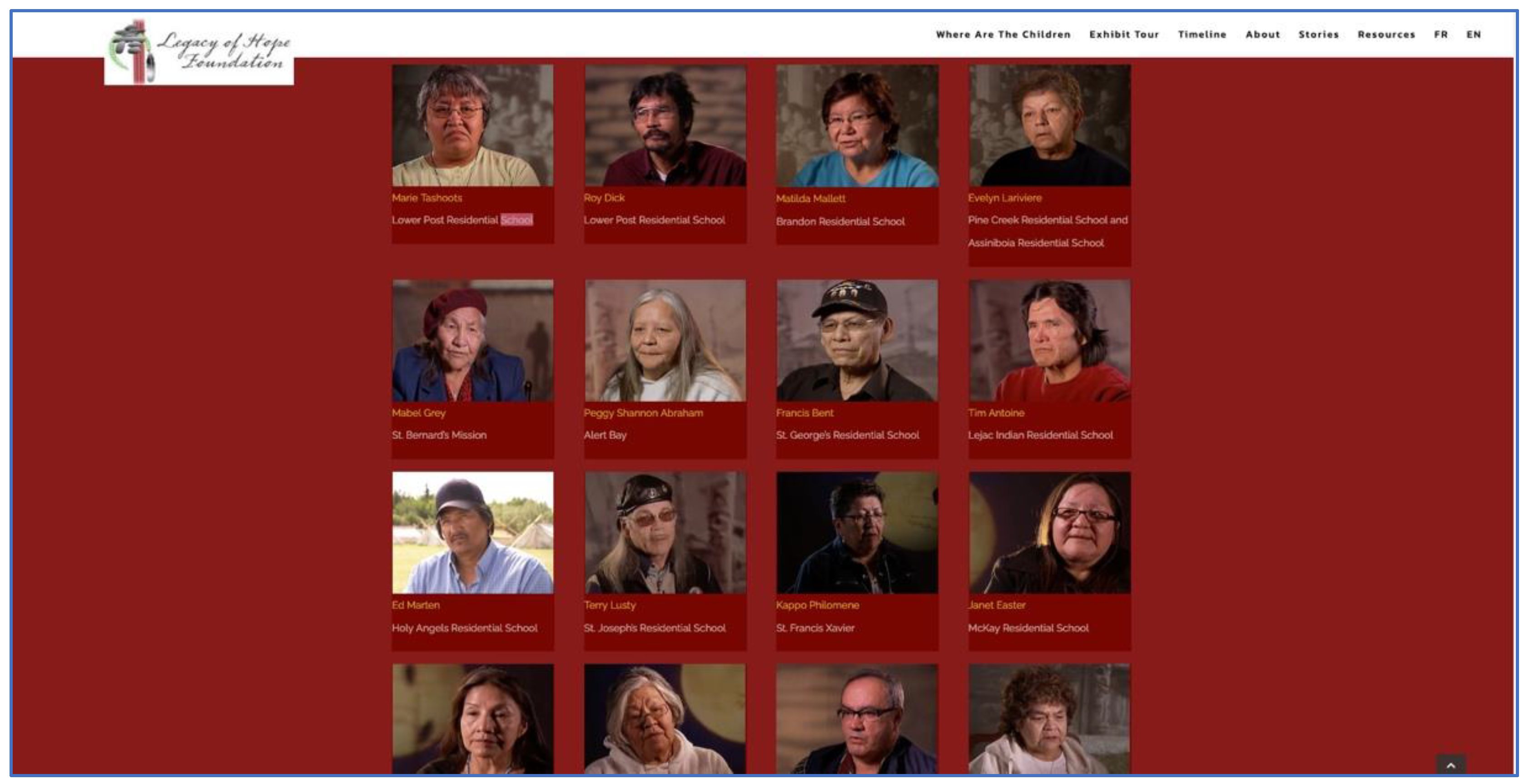
Following the launch of the Atlas, between January 2021 and April 2021, the third group of students participated remotely in the same course, which included the same sketch mapping exercise, this time linked to the MEME Project, a new collaborative mapping project, which began to emerge in July 2020. While teaching continued to involve references to the Residential Schools Land Memory Atlas (for example, using it as a presentation tool in conjunction with visits from guest speakers who had been collaborators on the project), there was a shift in the map-based platform from Nunaliit to GIAMedia. The first map created under this project, “On the Land”, emerged through work with and by students in INF1501H (Fall 2020) creating and mapping multimedia and written reflections in response to their surroundings [11,35,36]. Adapting lessons and mapping infrastructure established during this course and carrying forward a sketch mapping activity previously undertaken in conjunction with the Residential Schools Land Memory Mapping Project (based on the series of stories from the Legacy of Hope’s “Where Are the Children Website”), GIAMedia was used to create the new “Mapping Survivors Stories” content management website, which also continued to develop through work with and by students in INF1005H and 1006H (Winter 2021) in consultation with Jane Hubbard (Education Director, Legacy of Hope Foundation (LHF; see https://legacyofhope.ca/, (accessed on 1 April 2022)). With reference primarily to the LHF’s Survivor Stories page (see Figure 1), students were asked to review the interviews at their own pace until they had selected or adopted a story to focus their mapping exercise on. Each video is approximately one hour in duration and includes a soft interview approach with the same prompting questions posed to the participating survivors together with a written transcript.
2.2. Zooming in on Some Details of the Sketch Mapping Exercise
Taking an iterative and holistic approach to research and teaching which methods can provide context for the results and vice versa makes it challenging to discuss methods in isolation. In addition, a full appreciation of sketch mapping exercise methods can only be attained with lived knowledge of the details presented and discussed in the classes involving sketch mapping exercises. This section is thus a mid-level discussion of the methods employed at the intersection of research and teaching with respect to student sketch mapping of survivor stories.
With a focus on relationships, including student relationship to the storyteller and working together to identify students’ interests, visions, and commitments, the workshop approach to learning in these classes employed the same talk–templates–tradition approach taken in a previous work [4], which was consistent with the oral transmission of the knowledge methods advocated by Indigenous peoples and involved reflexivity and the emergence of new knowledge, understanding, and relationships. For example, the sketch mapping of survivors’ stories assignment evolved in relation to adapting the course content developed by a previous instructor and continued to evolve in an iterative fashion as a function of the collaborative relationships and the creative output of research assistant Annita Parish and all students who participated in the exercise, in addition to research relationships that emerged in the collaborative writing and mapping processes for Chapter 3 in Cybercartography in a Reconciliation Community, “Mapping Jeff Thomas Mapping” ([27,34]).
As background for the mapping approach to Residential Schools reconciliation, students were taught about the social and spatial justice aims of the project, especially in terms of intercultural reconciliation in a transitional justice framework, in addition to being exposed to aspects of critical cartography and transdisciplinary research and other contextual information regarding the Residential Schools Legacy and Indigenous perspectives (via readings, videos, and links to map-based and other websites; this was also part of the orientation phases for the project research assistants). Students were encouraged to learn about this legacy through direct and reflective engagement with the storytellers, stories, and additional rich information provided by guest speakers who were also collaborators on various aspects of the RSLMMP and the MEME Project. This encouragement was reflected in the course curriculum, which included a choice between exercises linked to stories told by individual survivors in the sketch mapping exercise, and the news story summary and reflection mapping exercise, which revolved around stories reflecting the many dimensions of the Residential Schools Legacy (years two and three), while, in year one, students who did not choose the sketch mapping exercise conducted online research and mapped information related to the many truth and reconciliation projects funded under the Indian Residential Schools Settlement Agreement, which was conducted only in the 2019 class [27].
The collaborative approach to the research focused on the design and development of digital map-based interactive websites with partners and research assistants both informed and was informed by teaching and learning in a university classroom context, where teaching from a collaborative education mapping perspective emphasizes inclusivity and reciprocity and aims to create a welcoming teaching environment for students that is attentive to the differences in learning styles [27]. Moreover, the teaching method evolved in conjunction with the evolution of the research projects and involved the same two-pronged approach to integrating critical academic and Indigenous perspectives that was developed in the projects to develop the cybercartographic Lake Huron Treaty Atlas [3,31], in addition to an arational talk–templates–tradition approach to iterative processes in the method development [3,4,37], combined with emergence and reflexivity, where “reflexivity” can be considered “a philosophy, a research method or a technique” [38] (p. 984). Reflexive methods, including a focus on positionality and personal reflections, are of particular significance in both the atlas and map development research and related teaching, especially given the inclusivity of reconciliation with respect to the Residential Schools Legacy, which can be seen from institutional to personal spheres [27].
A modeling approach to sketch mapping was employed in an effort to provide gentle guidance while leaving room for individual expression and creativity. It is in this regard that methods can also be viewed as results and that the notion of taking an iterative approach is relevant. For example, for the first group of students who participated in the exercise (2019 class), the initial models included those provided by RSLMMP research assistant Annita Parish and a paper by Brenda Wastasecoot [39], “Nikis Memory Map: A Cree Girl Speaks from the Past” (which was an item in the previous instructor’s resources) that includes a sketched memory map of her childhood home. As the course continued over the following two years, students had progressively more sketch mapping examples from previous students to consider, and the output was generally categorized in the following three categories: analog drawing, digital drawing, and mixed media. Additionally, given the short six-class duration of the course, students were reminded that they were doing a sample exploratory exercise that should involve witnessing their survivor’s entire interview yet only producing a sample of reflections and salient survivor memories in their sketch map output. In this regard, instruction combined the idea of learning from models with advice for students to retain their positionality and their empathy for the storytellers. In addition, a broad approach to both “sketch” and “mapping” was emphasized, such that each student had plenty of scope to develop their own customized approach and understood that the exercise was more about establishing a relationship with the storyteller through their work rather than being about creating a finished product or telling someone else’s story.
In general, the following ideas or aspects were important to the sketch mapping methods:
- Taking time to review and choose/adopt a story;
- Tracking sketch mapping process, including working notes;
- Selecting memories that resonate;
- Portraying geography of story;
- Written map interpretation/reflection;
- Witnessing, yet going beyond and involving reciprocity in terms of giving back by sharing impressions, lessons learned, aspects of process;
- Reflecting courage and respect, among other Seven Grandfathers Teachings.
Although reflexivity was prominent in many ways during the workshop course, it was especially prominent in the sketch mapping exercise for which the sketch mapping processes described above comprised part one. Part two involved students either providing permission to upload digitized sketch mapping output to the Residential Schools Land Memory Atlas (for years one and two) or students directly uploading their sketch mapping output to their class GIAMedia map-based site (for year three). While both platforms can be used as teaching tools for both knowledge dissemination and knowledge creation, there are some important differences that influenced some of the methodological specifics. In all classes, guest speakers talked about their involvement in Residential Schools reconciliation initiatives, and teaching included talk of reflexivity, with emphasis on the process. It is also important to note that individual discussions and consultations between teacher and students took place in both in-person and remote contexts in relation to sketch mapping approaches and ideas.
3. Results: Student Output as a Function of Research and Teaching
The following two subsections present a small subset of results from the new awareness-building digital pedagogical mapping methods that are developing with the sketch mapping of the stories of the residential school survivors from the Legacy of Hope’s Where Are the Children website. These results comprise a sketch of the iterative, emergent, and flexible nature of the reflexive mapping exercises that have been developing at the intersection of research and teaching over two projects: The RSLLMP and the MEME Project. Focusing on the output of several authors of this paper (Annita, Peter, and Shawn) provides an alternative venue to present their work in addition to their presence in the map-based content management websites discussed in this paper.
3.1. Sketch Mapping Survivor Stories for a Cybercartographic Atlas
As stated above, there is a holistic relationship between the methods and results in this work, such that the results feed back into the methods, becoming models for the creation of future results. In this regard, all of the sketch maps produced by previous students who consented to publishing their works in the Residential Schools Land Memory Atlas reflect their unique positionalities while providing models for subsequent students to inform their approaches. While the students followed the same general method, each student inevitably generated unique approaches as a function of their individual characteristics and the characters of the survivors whose stories they were mapping.
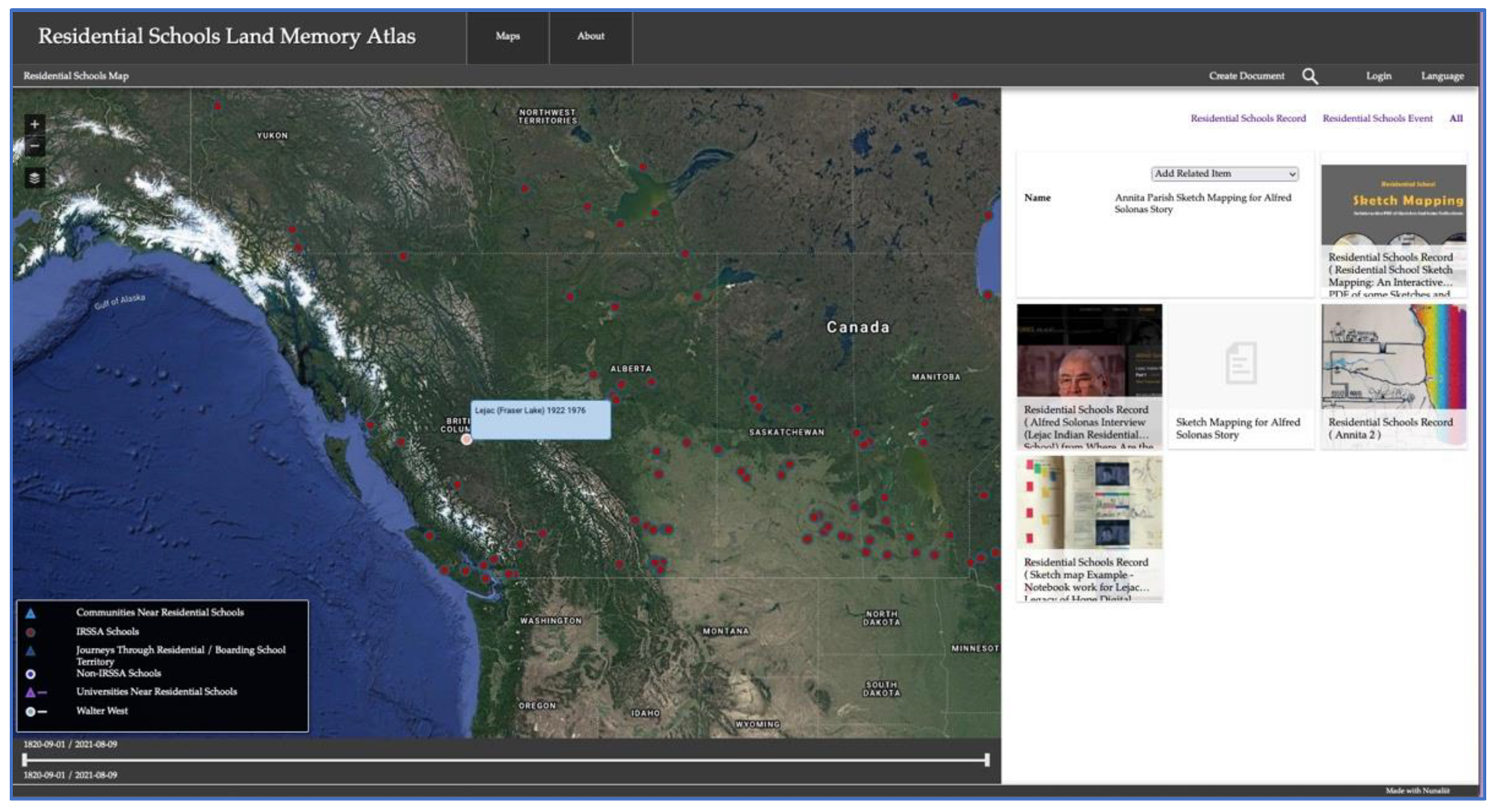
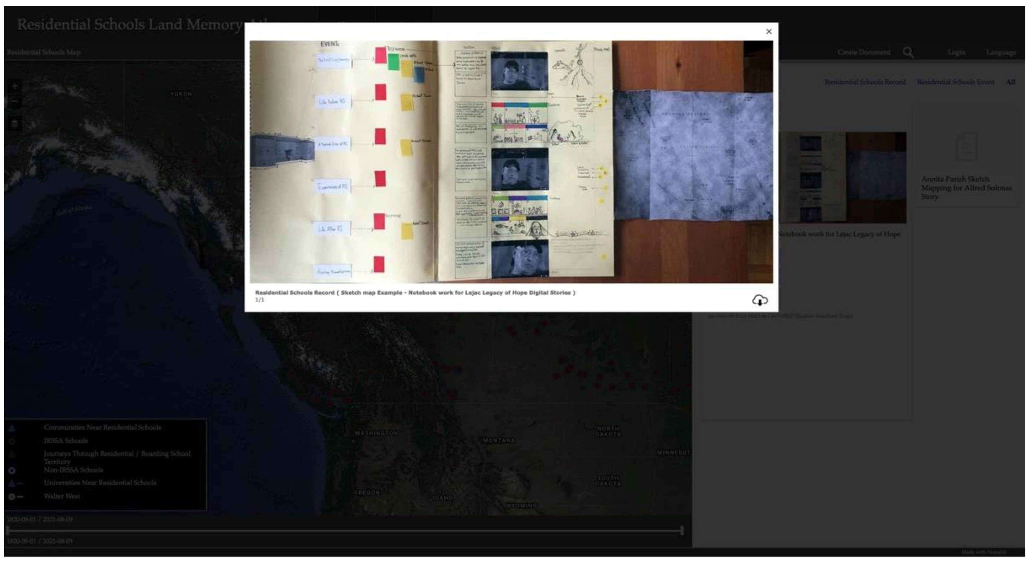
Work with Annita Parish on the sketch mapping involved much devotion and time in terms of the discussion and review of Annita’s initial sketch maps, which were, in turn, used as the initial models for the students to refer to in the development of their own unique approaches. Annita spent months reflectively and reflexively sketch mapping the stories of the survivors who attended Lejac Residential School while in continual dialogue with Stephanie (as both lead researcher and course instructor). This work progressed in an iterative fashion, explored a variety of approaches, and requires a dedicated paper to present in sufficient detail. The sketch mapping by Annita in Figure 2 shows thumbnail views of some of her work on the sketch mapping of her salient and geographical impressions of the story of Alfred Solonas, a survivor who went to Lejac Indian Residential School in British Columbia, while Figure 3 illustrates a full view of the thumbnail for a photo of the portions of Annita’s sketch mapping book, which presents both the results and exploratory processes.
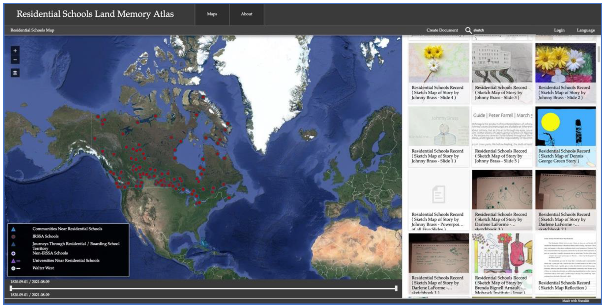
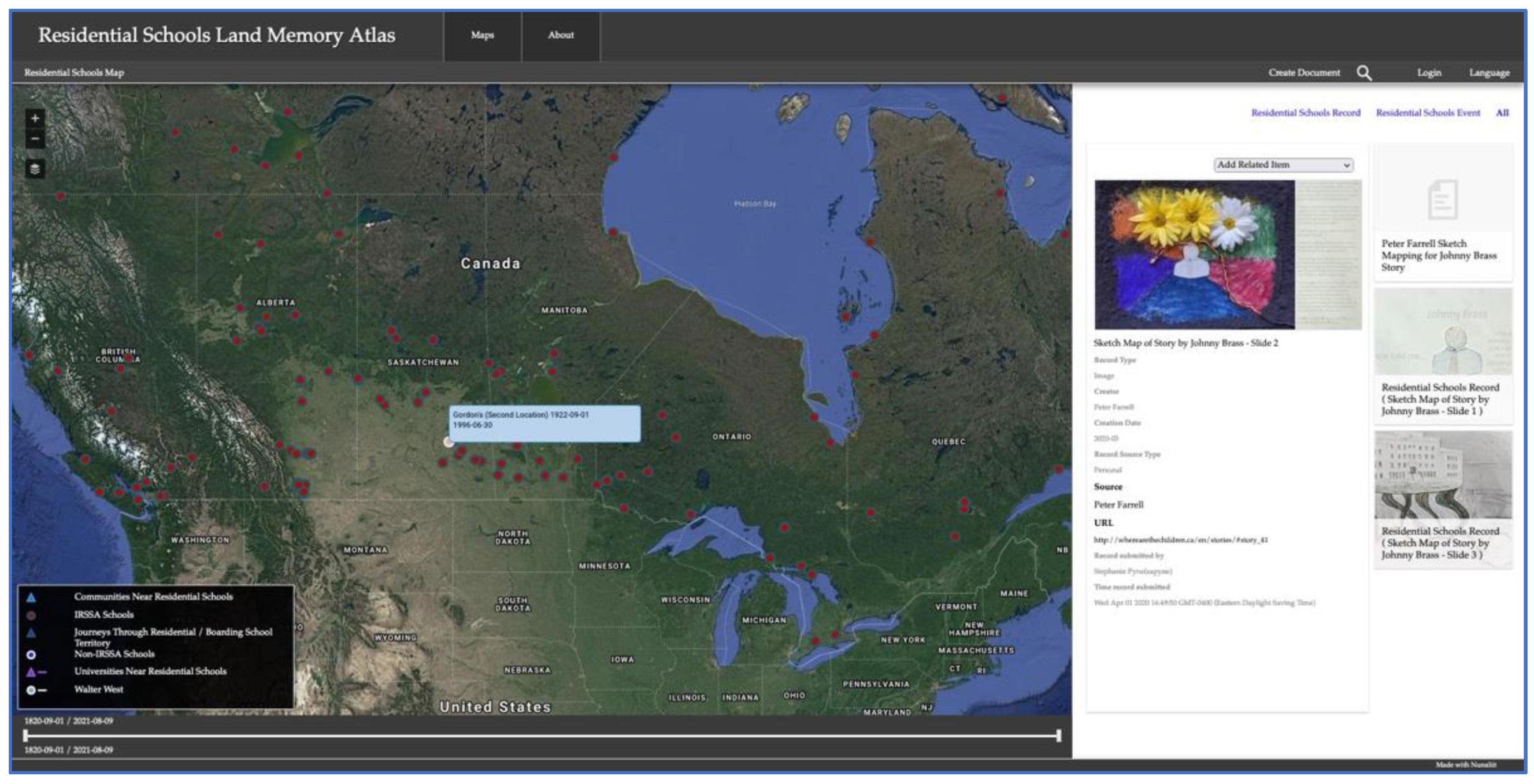
Most of the sketch mapping—especially in year one—involved analog drawing that was later digitized and added to the Atlas to display on the Residential Schools Map. However, with an emphasis on positionality and encouraging students to “come into a relationship” with the storytelling through their sketch mapping, digital and mixed media approaches also began to emerge over the three years of classes. The incredible degree of variation while maintaining common themes makes each student example worthy of presentation, and consequently, we decided to present some examples created by several authors of this paper. The Residential Schools Map is the best place to review the years one and two sketch mapping results, which can be accessed in a variety of ways, one simple way being to search “sketch” to produce a series of thumbnail results in the map’s side panel (see Figure 4) (Since the Atlas organizes documents via relations, it is necessary to click on the related documents to a selected document, one of which is the place document. This document includes a “find on map” feature, which, if clicked on, will identify a point on the Residential Schools Map for the residential school attended by the survivor whose story is being sketch mapped. In addition, it is easier to view results on the map if the overlay for IRSSA schools is the only overlay being viewed).
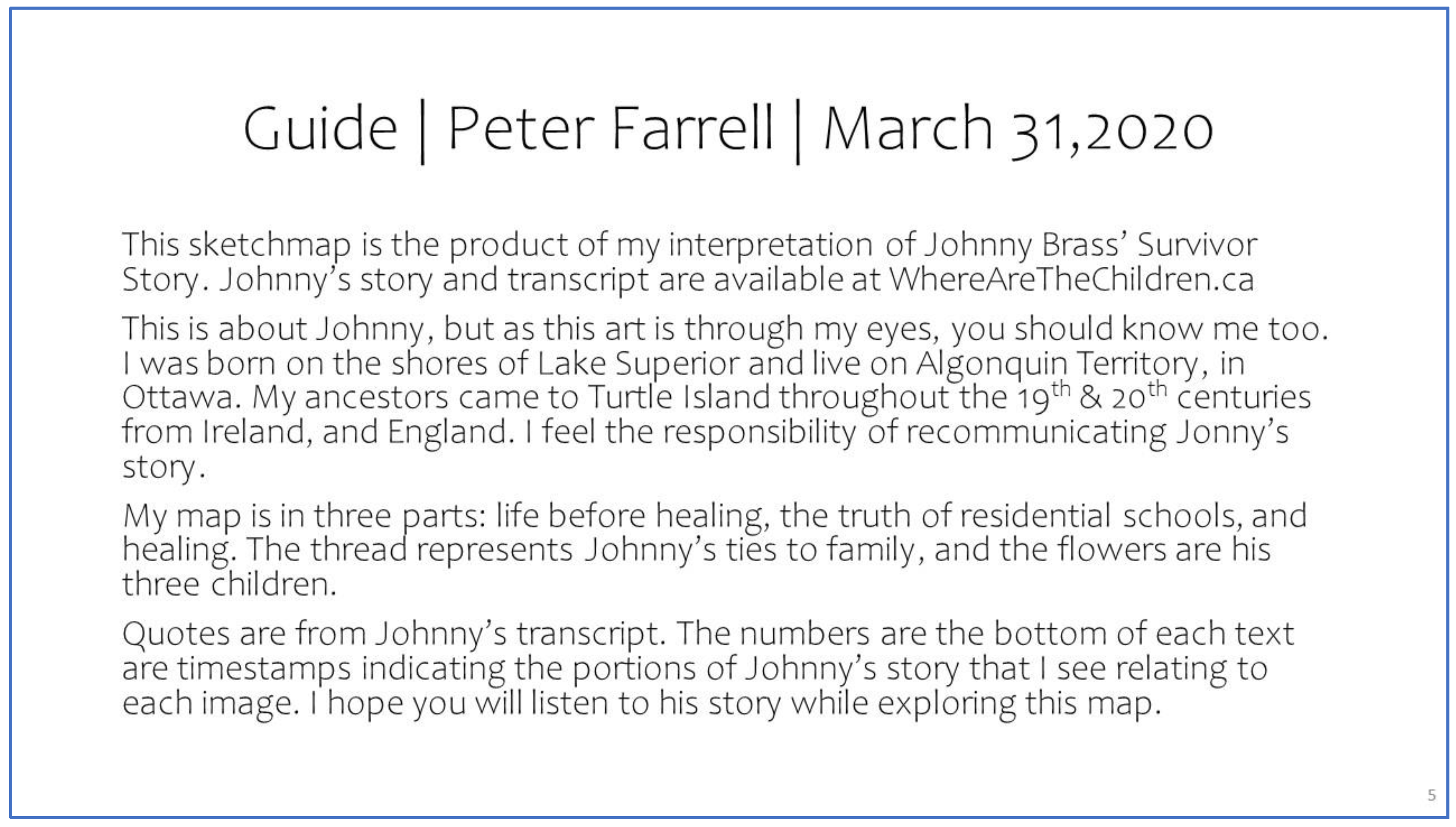
Although most examples are primarily analog drawing, sketching, or painting, there has nevertheless been plenty of diversity in the approaches, including mixed media, performative examples, and digital examples of many varieties. This diversity reflects an emphasis on positionality, which—in a positive light—includes a focus on the awareness of our own individual perspectives, gifts, and abilities. Sketch maps included a variety of features, with many profiling quotes from the survivor stories that resonated with them and/or reflected certain iconic memories of experiences, for example, journey to school for the first time, a typical day at school, life after residential school, and memories of home, with part of this consistency being due to a similar soft interview approach taken by the LHF in the survivor interviews. In addition, many students included excellent comments on their positionality and mapping processes. For example, Peter Farrell, a student from the second year of this class, chose a mixed media approach for his sketch mapping of Johnny Brass’s story and included an interpretative guide (see Figure 5 and Figure 6).
Peter’s mapping approach reflects a concern with positionality and his awareness of the sacredness of Johnny’s story. A closer examination of Peter’s mapping work beyond the thumbnail view in Figure 5 is more apt in the online environment; yet, for the purposes of this paper, it is worth drawing attention here to the reflexive relationship between the written narrative and “graphic” expression in the sketch mapping exercise.
In a weekly class reflection, Peter acknowledged the depth of the sketch mapping exercise that is no doubt linked to the power that maps and mapping processes have when it comes to engaging with stories, in addition to the sacredness of the stories themselves:
The sketch map assignment pushed me to engage more deeply with the stories of residential school survivors. This is the content at the core of the Truth and Reconciliation Commission process. While I am familiar with the TRC Calls to Action, have read novels, listened to stories of survivors, and facilitated learning experiences for others around residential schools, I have never attempted to interact so deeply with a story so as to interpret and recommunicate it to others. This was scary for me, and, despite my Grade 3 level art skills, I am proud of what I made. Thank you for setting a goal and encouraging me along the way.
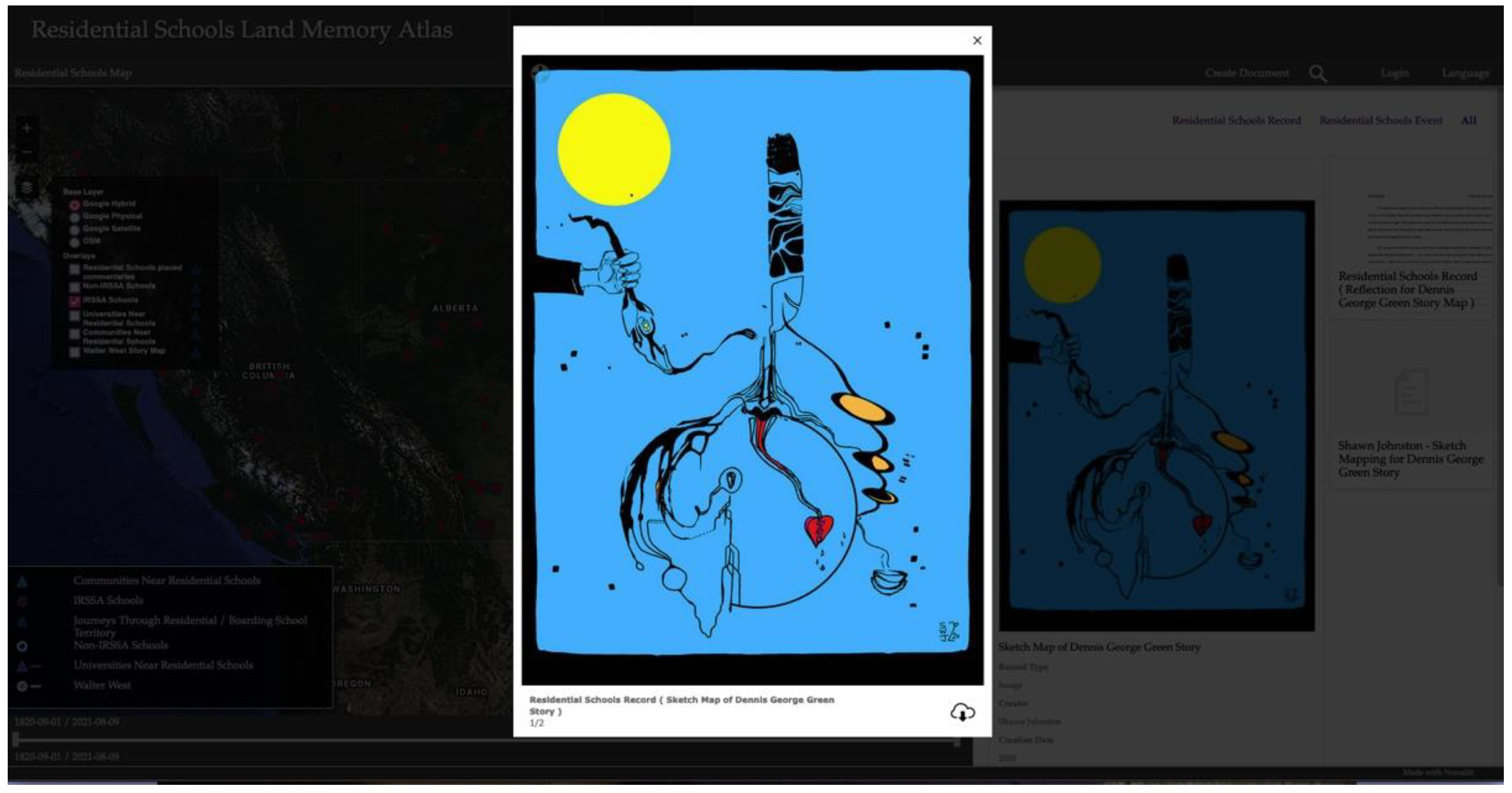
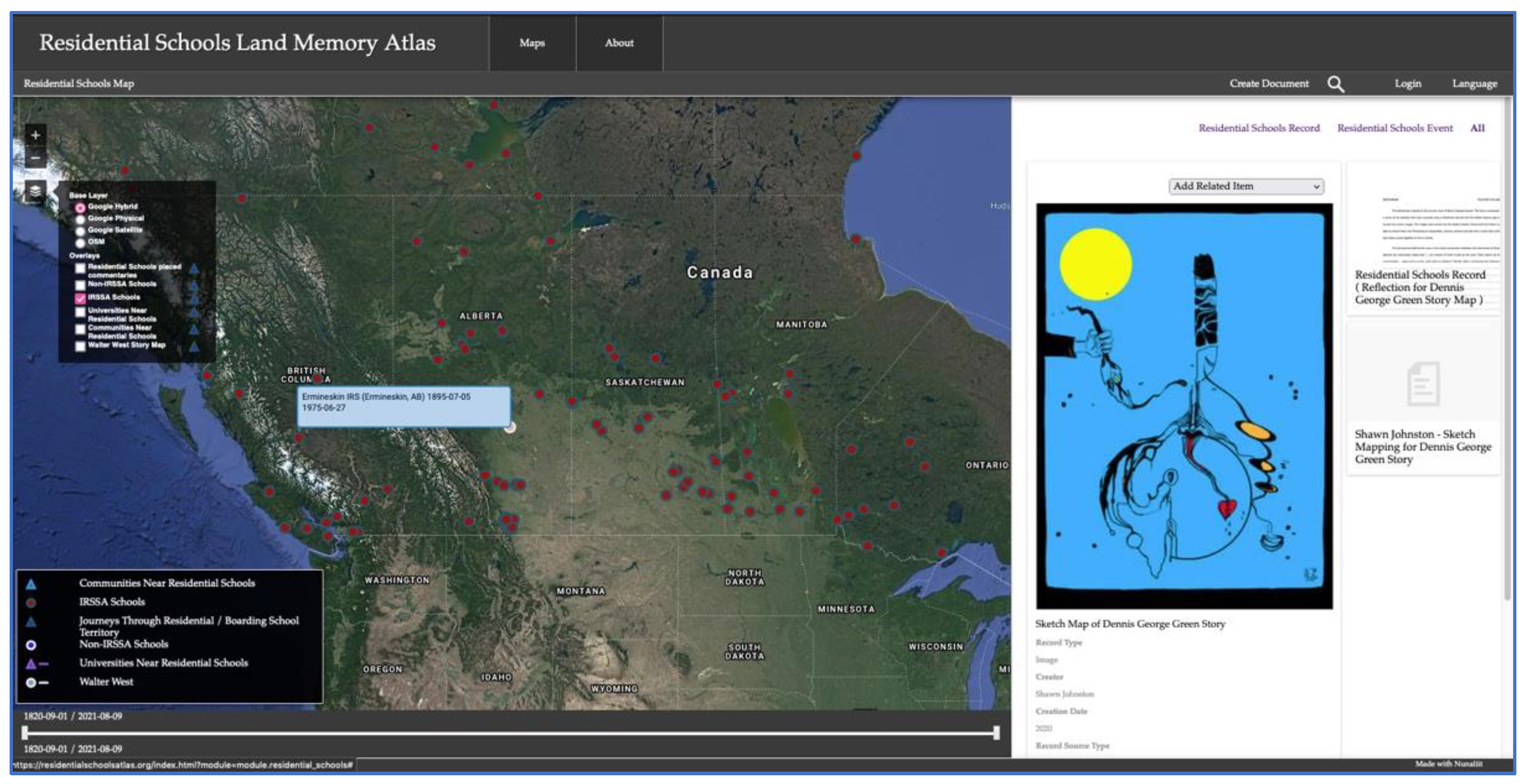
Several other students across all the years of the class took a mixed media (including mixing analog and digital) approach to their sketch mapping of a survivor’s story, producing an array of interesting and thought- and feeling-provoking examples. Some of these are included in the RSLMA and others are in the class-specific Sketch Mapping Survivors Map discussed below. An excellent example of blending analog and digital modes and creating an artwork that can be read like a map is the sketch map of Dennis George Greene’s story by Shawn Johnston, also a student from the second year of the class who was, at the same time, a practicing artist and a returning guest speaker to subsequent classes (see Figure 7 and Figure 8).
As a vital component of their sketch mapping output, Shawn included the following useful reflective interpretation of their map art in their contributions to the Residential Schools Land Memory Atlas:
This sketch map is based on the survivor story of Dennis George Greene. The map is composed of a series of ink sketches that were scanned using a Moleskine Journal and the Adobe Capture app and turned into vector images. The images were saved into the Adobe Creative Cloud and from there I was able to import them into Photoshop to reassemble, colorize, connect and edit into a visual story where each piece comes together to form a whole.
The driving force behind this map is the initial conversation between the interviewer and Greene wherein the interviewer states “… our version of truth is told on the land. That’s where we find reconciliation … when we’re on the earth with our Mother” (00:38). When considering this statement, and after visiting and revisiting Greene’s own discussions around fear of the unknown, silence, and the benefits of breaking the cycle, I imagined Greene’s face imprinted upon or embedded within the ground of the earth. I saw him as one of the misdirected warriors he talked about. One that is arising from a slumber, moving toward or readying for battle, but not yet in battle. I visualized Greene’s truth as a tree growing out of the opening of his mouth; telling the story of an individual who on one side is strong and resilient yet disconnected on the other; dislodged from the self. An individual who was unplugged from their community and their ‘essence’ by the Residential School system at an early age. The right side of the tree is half of a feather representing the strength that resides within Greene. It encompasses Greene’s journey; his self-evolution and actualization and represents the strength revealed in the telling of his survivor story. The left side represents Greene as a ‘seedling’ being unplugged by the hand of the priests and nuns of the Ermineskin Residential School. The broken tree retains its prongs, suggesting that a re-connection is possible.
The broken heart has multiple meanings. I felt there was a lot of sadness in this story. Greene references instances where he and the other children were deprived of love, touch (and trust in others), praise and approval from those in charge of the schools. Greene addresses the generational effects that have trickled down to the children and grandchildren as a result, perpetuating pre-existing patterns of loveless, broken and chaotic relationships.
The seed attached to the mind behind the eye is a new growth that it is being cultivated by the subconscious and is developing upside down. The lines that stem from it suggest that it takes longer to break the surface as they are reaching towards (to break through) the other side of the earth. Hope exists in a small piece that has broken through the ground. This new growth must seek the sustenance of the sage bowl on the right. The smoke that comes from the sage bowl will then carry the new growth through the 3 moon phases and back into the feather (I realized afterwards that this is representative of episodes from season 3 of the Chilling Adventures of Sabrina where the Spellman family call to Hecate, invoking the power of the triple moon (maiden, mother, crone). This moon phase represents path of life cycle, as well as a cycle of the phases of Greene’s self-reflection and realization.
Finally, the tears from the broken heart send water to the bottom of the earth. The seed senses this and grows in that direction so that it can flourish. The black dots are the memory traces, the frequencies that hang in the air around us and the earth. It is unclear whether they are guides, or just various paths that lead back to the self.
The emphasis on reflection and self-expression in the class was aided by a weekly brief reflection exercise, which, in the case of Shawn’s final class reflection, included further reflections on their experiences sketch mapping the story of Dennis George Greene, including thoughts on the importance of a meta-literacy linking education to daily life and comments on how the course provided a reflexive context for the sketch mapping exercise:
I really enjoyed this workshop and have had such a rewarding experience hearing the guest speakers; watching videos related to Indigenous culture and customs; reading about the mapping process and exploring oral/visual storytelling. I enjoyed how you gave the class the ability to reflect on the information that we were receiving each week and felt that reflecting helped me to look within myself to establish meaningful connections with the course materials that could be carried forward into my education, artistic practice and everyday life. I have experienced a full range of emotions over the past six weeks, especially while hearing the various survivor stories on the Where are the children website. I am so thankful that I found the story that I ended up choosing. The experiences Greene recounted, the truths I heard him reveal and the wisdom that he has cultivated within himself has touched me very deeply.
Another important aspect of the sketch mapping assignment was adding the students’ work to the Residential Schools Map of the Residential Schools Land Memory Atlas, which was the most apt home for this body of work. Given the abundance of student work, and in light of previous challenges with a large number of people uploading content at the same time [20], the choice was made to involve a small team of RSLMMP research assistants and student volunteers for the task of adding this content to the atlas, in addition to other related tasks. More than 100 students participated in the sketch mapping exercise and gave permission for their work to be added to the Atlas.
3.2. A Class Map Website Approach to Residential Schools Reconciliation Education
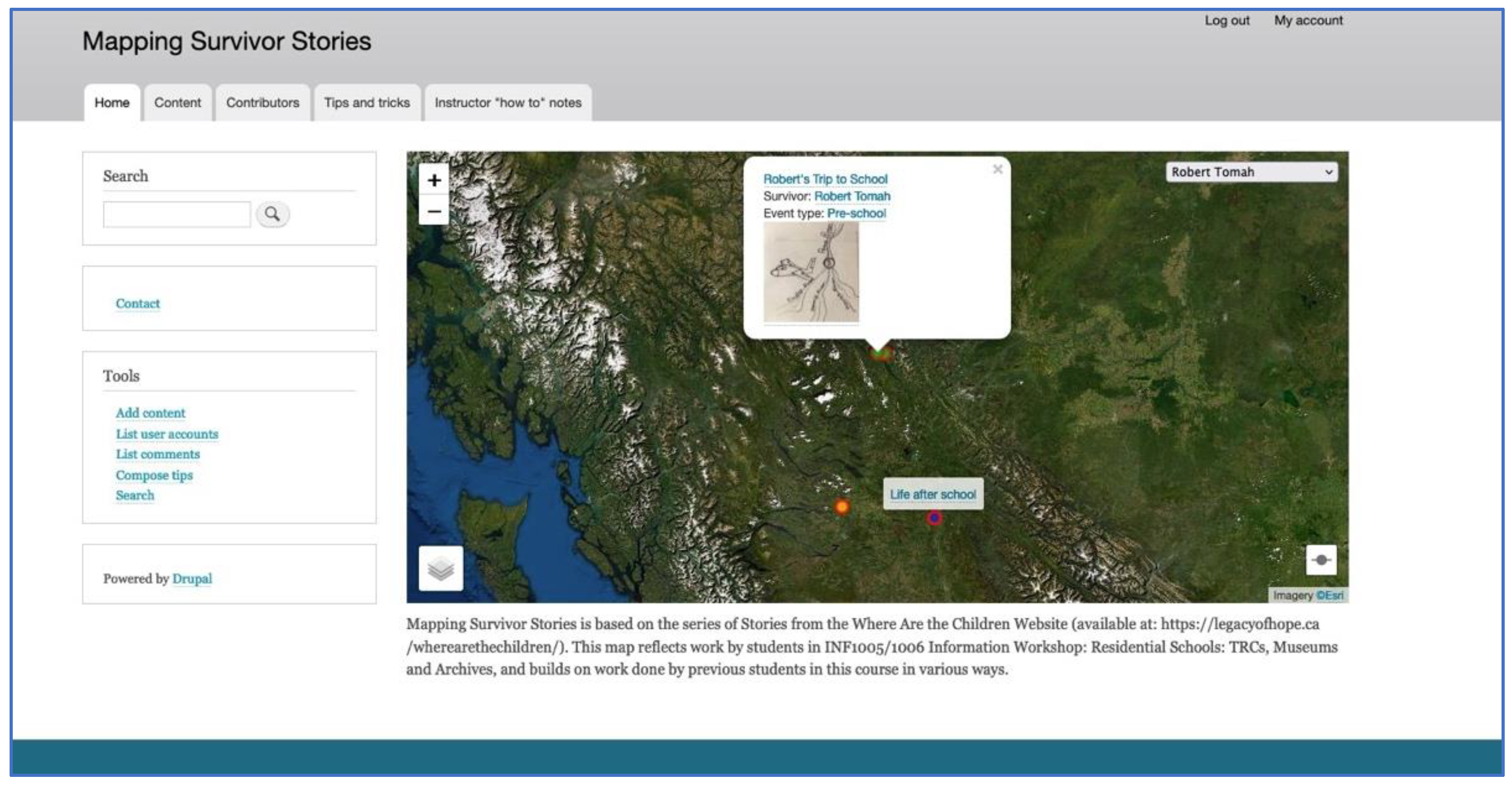
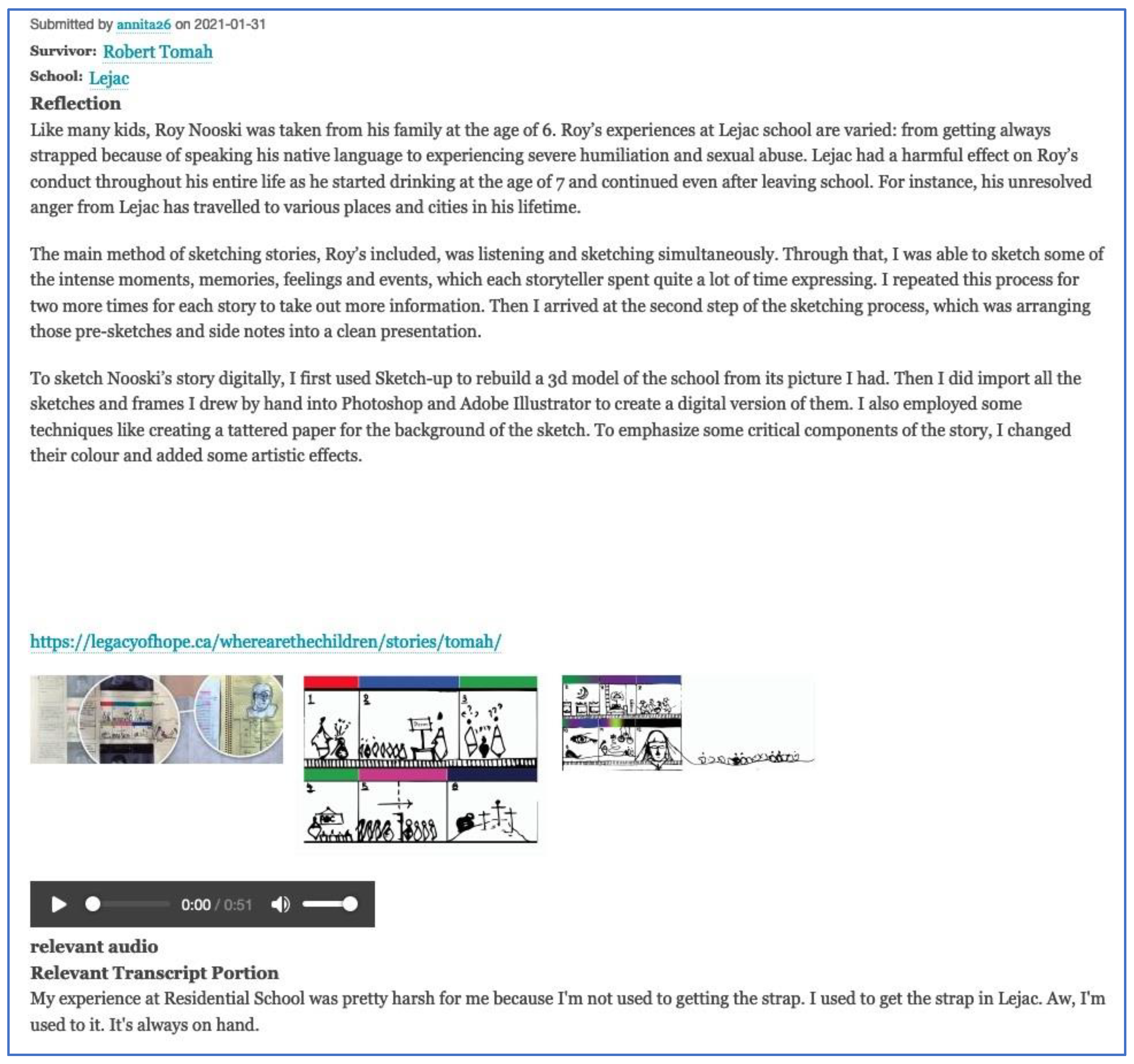
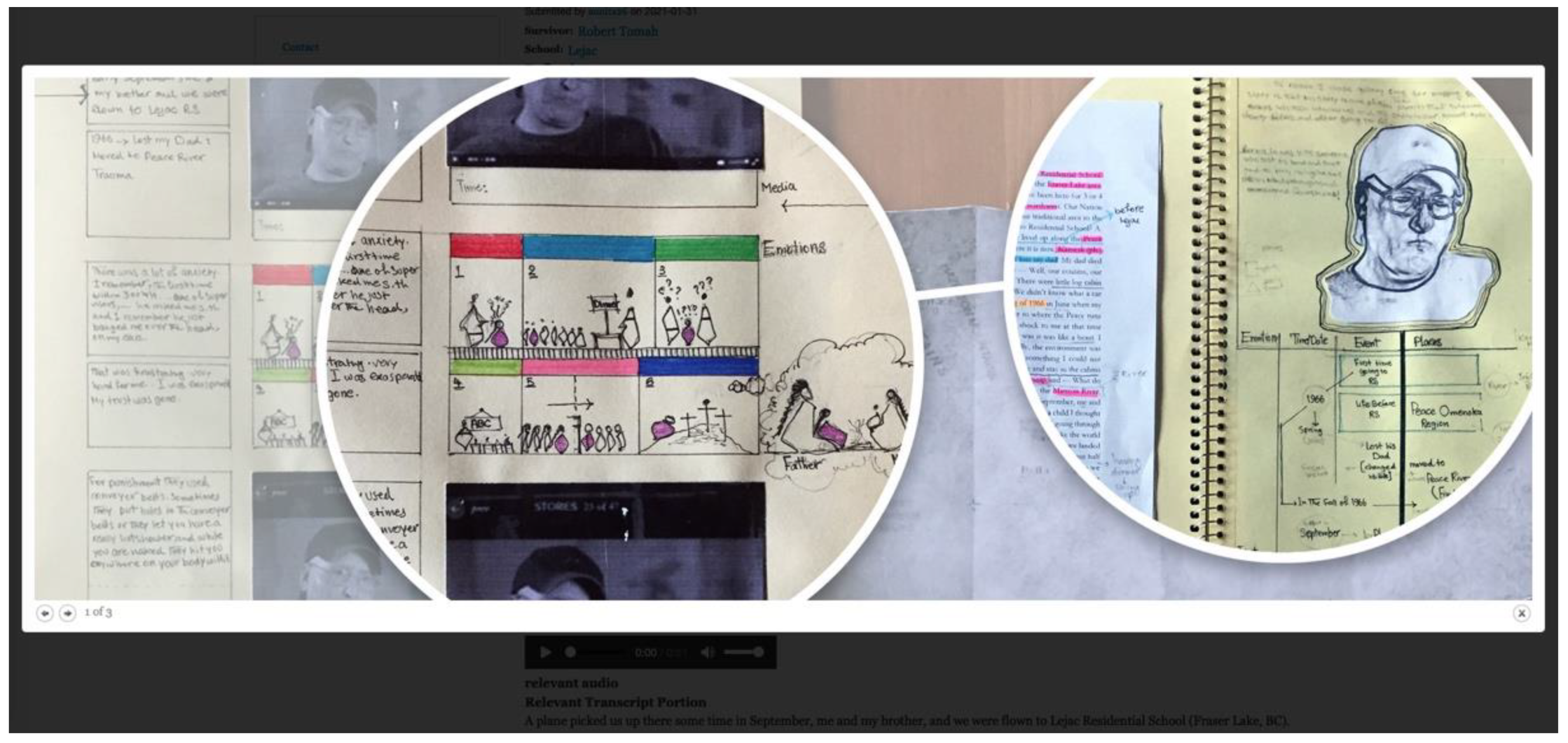
Year three of the class followed the launch of the Residential Schools Land Memory Atlas and involved the use of a new GIAMedia framework and the creation of a map-based content management website devoted solely to the sketch mapping exercise. At the same time, this class-based website development was part of the open-ended digital pedagogies research project, the MEME (Multimedia Emergent Mapping for Education) Project, which is focused on the research and development of small group and class maps that are viewable only by the participants—in this case, the participating students. With attention to issues such as privacy and information ownership considerations, student contents in the Mapping Survivor Stories map are not currently available to the public, although consultations with student contributors are underway regarding the future of the map work. With this said, Annita Parish has given permission to share examples of her sketch mapping content in the Mapping Survivor Stories Map. Figure 9, Figure 10 and Figure 11 show three different views of Annita’s sketch mapping output for the story of Robert Tomah, with Figure 9 showing a thumbnail pop-up for Robert’s memory of flying from home to begin his attendance at Lejac Residential School. The orange dot on the map signifies both the school’s location and the existence of a document containing the sketch mapping content related to Robert’s school-based memories.
Figure 10 shows a full document view of this school-based memory document, which includes a written reflection and multiple multimedia files, where the written reflection includes comments related to salient points of Roy’s story and a summary of Annita’s unique sketch mapping methods.
Figure 11 shows a full-screen view of one multimedia item from the school-based memory document and illustrates another possible view in the GIAMedia website.
4. Discussion
Concomitant with the five converging trends of geo-awareness, geo-enablement, geotechnologies, citizen science, and storytelling is the emergence of a “geoliterate population”, which can increasingly make appropriate decisions through the assessment and use of geographic information [9]. Going beyond narrow views of “geoliteracy” that are based on a foundation of “spatial, area studies, man-land, and earth science [in addition to] movement, region, human-environment interaction, location, and place” (2015, p. 17), Kerski linked “geoliteracy” with the idea of an interconnected and multidimensional world and suggested that “geoliteracy” should refer more broadly to knowledge relating to “how our world works, is connected, how to make effective decisions, or interactions, interconnections, and implications” (2015, p. 17). A linked and perhaps broader concept that could be seen to incorporate “geoliteracy” is “metaliteracy” [5], a concept referring to the knowledge capacity across disciplinary and other domains.
Kerski described what he calls the three legs that form the stool of geoliteracy: (i) the core content (i.e., systems thinking); (ii) building skills to use geographic tools (with a focus on the geographic inquiry model, tackling difficult problems); and (iii) the geographic perspective (including spatial thinking and critical thinking), which no doubt interacts in a mutually reinforcing, holistic, and reflexive fashion. Appreciation for geoliteracy is reflected in the funding of various projects in the United States, and Kerski advocates for a push from educators, many of whom have readily incorporated geospatial tools to support student engagement and learning [9].
As is intimated by the variety of relatively recent examples from the literature provided in the introduction, digital cartography has been incorporated into the curriculum of a diverse array of disciplines (and inter-disciplines?), each with its own literacy. In this regard, Andrzej Rutkowski and Stacy Williams [5] discussed the importance of metaliteracy in the context of their work with students during an undergraduate writing course at USC Libraries, University of Southern California, Los Angeles, which aimed to nurture spatial thinking and metaliteracy by enhancing pedagogical resources beyond the library resources and by developing better search terms and research strategies [5]. Their strategy was to intentionally apply the existing Association of College and Research Libraries (ACRL) Framework for Information Literacy for Higher Education and to introduce multiple literacies by framing their assignments and final project around a spatial ethnography of a neighborhood (engaging with archival/primary source documents, in addition to adding their own secondary and tertiary source materials through research and compiling photographs and textual documents that were then mapped and shared on a digital platform). Going beyond educating students with respect to technical knowledge, they “wanted students to think more critically about data at the geographic level of a neighborhood and how it impacts people and communities” (Rutkowski and Williams, 2019, p. 222). They also “wanted a way to synthesize a set of writing assignments that would use archival material and lead to student published essays online that would be accessible through an interactive map” (Rutkowski and Williams, 2019, p. 222).
The concept of “metaliteracy”, as it appears in the ACRL Framework, was incorporated as a means of thinking about how the course was designed (using original digital materials, resulting in a collaborative digital project) and how the students would interact with a variety of technologies as producers, collaborators, and distributors. Students were encouraged to incorporate “self-awareness of place and how it impacts and creates knowledge” (Rutkowski and Williams, 2019, p. 222). This emphasis reflected an awareness of the spatial turn described by Edward Ayers [40], who proposed that, as we struggle to convey temporal and spatial data with text alone, digital mapping tools might actually be the most effective way to demonstrate certain kinds of large-scale changes (deep contingency) and complex patterns as they transform in space over time and explore the ways in which digital mapping tools can incorporate movements to convey time (and space), thus providing an engaging visualization to which the human brain responds favorably.
While the five emerging trends identified by Kerski may support the development of geo- and meta-literacies in the general population, incorporating critical approaches to digital cartographic pedagogies can only serve to enhance and push the boundaries of the possibilities in this regard through the complementary support of critical cartographic (or carto-) literacy, where carto-literacy can be seen to require a broad view of mapping that reflects the main trends in critical cartography, including challenging the conventional status quo assumptions about space by emphasizing deconstruction, reconstruction, or both [31,41,42,43,44] and favoring approaches that can be consistent with Indigenous perspectives and understanding. Examples of this are the rejection of binary distinctions and the preference for a performative approach to cartography advocated by Vincent Del Casino Jr and Stephen Hanna [45] and the emergent approach to mapping described by David Turnbull [37] and Robert Kitchin and Martin Dodge [46], in addition to emphasis on the reflexivity and reflexive methods [3,47]. As Margaret Pearce and Renee Pualani Louis [48] emphasized, when it comes to engaging with mapping in a way that involves Indigenous peoples, ‘‘[t]he problem that faces Indigenous peoples worldwide is to find a way to incorporate Western [geospatial technologies] and cartographic multimedia while minimizing the mistranslations, recolonizations, and assimilations of conventional technoscience’’ (Pearce and Louis, 2008, p. 123).
Critical cartographic literacy has been recommended, especially in cases involving Indigenous mapping and education, where it is important to be aware of the ways in which Western cartography is rooted in the same Cartesian–Newtonian epistemology that underpins the colonial worldview. Advocating a two-pronged approach, Jay Johnson, Renee Pualani Louis, and Albertus Pramono [49] discussed some related tensions and challenges: “To engage the technologies of Western cartography is to involve our communities and their knowledge systems with a science implicated in the European colonial endeavour and is a decision which should be made only after examining not only our past experiences of colonial mapping/surveying but also the long history of Western cartographic traditions” (Johnson et al., 2006, p. 82).
Engaging Free and Open-Source Software (FOSS) platforms in digital pedagogies involving mapping could provide a fruitful path forward in developing two-pronged approaches to curricula involving Indigenous Peoples and knowledge. In this regard, the sketch mapping exercises with university students that have been evolving over the past three years have been doing so in conjunction with two distinct but interrelated research projects, each involving the design and development of distinct FOSS platforms. Regardless of the platform and research project, all courses reflected a reconciliation context and involved the development of an environment for safe sharing and the fostering of initiative, in addition to involving much talk with students (especially in remote teaching). Additional shared aspects can be appreciated in terms of Kerski’s [9] pedagogical recommendations for promoting and supporting geoliteracy, which include the following: help students engage with the tools, engage the research community, promote civic engagement, tell stories with maps, and focus on change (2015, pp. 20–21). According to Kerski, “students who are well grounded in the spatial perspective through geography may be better able to use data on a variety of scales, in a variety of contexts, think systematically and holistically, and use quantitative and qualitative approaches to solve problems” (2015, p. 22), where engagement with spatial thinking, inquiry, and problem-based learning also aligns with education for activism (2015, p. 25). Both approaches include these aspects, each in different, yet related, ways.
While Kerski [9] made a series of relevant and useful recommendations for “[seizing] the opportunity […] to actively promote the inclusion of geographic content knowledge, skills, and perspectives throughout education and society” (2015, p. 19), the example he provided made use of proprietary software. If we were to add to his well-considered recommendations, we would include a recommendation to employ FOSS in the map-based website design and development for pedagogical purposes. Referring to a variation of FOSS, Yu-Wei Lin and Matthijs den Besten [50] were particularly concerned with gender-based exclusions and barriers in FLOSS (free/libre open-source software) environments, where they understood FLOSS as “the result of many incremental innovations contributed by people located in different places around the world […], which include[s] the freedoms to study, change, distribute and redistribute source code” (2019, p. 1018). They are part of a larger field of FOSS community engagement in justice-related thought, including issues related to responsibility, identity, inclusion, and motivation [51,52,53,54]. With FOSS as a central foundation for both RSLMMP and MEME, this means an enhanced awareness and engagement of students with “mapping platforms”, which have intrinsic, in addition to instrumental, value; map-based pedagogical projects that use proprietary software tend to lean more towards a solely instrumental valuing of mapping platforms.
When it comes to recommendations for digital map-incorporating approaches into educational contexts involving Indigenous contents and themes, we further recommend reflexive and emergent approaches where increasing the skepticism of the neutral, objective “scientific gaze” has led an increasing number of social science practitioners and other scholars to adopt “a reflexive stance in which we recognize all social activity, including research itself, as an ongoing endogenous accomplishment” (Cunliffe, 2003, 983). Reflexivity is a dynamic and multidimensional concept that invites holistic, pan-disciplinary interpretation, and resisting reduction and binary opposition, “reflexivity” has a broad application at multiple scales. Perhaps at its most general level of applicability, “reflexivity” means ‘to bend back upon oneself’” (Finlay and Gough, 2003, p. ix), which indicates a cyclical, as opposed to a linear, perspective. Linda Finlay and Brendan Gough [55] identified some of the main strands of the investigation involving reflexivity, including “the humanistic-phenomenological and psychoanalytic emphasis on self-knowledge, ‘critical’ traditions such as feminism, which prioritize socio-political positions, and social constructionist and ‘postmodern’ approaches, which attend to discourse and rhetoric in the production of research texts” (Finlay and Gough, 2003, p. 1). Although discourse on reflexivity may not be identical to Indigenous approaches, the concept is consistent with their holistic aspects.
According to Ruth Nicholls [56], “researchers need to engage with reflexive evaluation of collective and negotiated design, data collection and data analysis to consider inter-personal and collective dynamics during the research process” (2009, p. 117). Nicholls further recommended participatory and collaborative methodologies for research involving Indigenous peoples, a recommendation that could be extended to educational contexts, and advocated applying multiple layers of reflexivity in research involving Indigenous people, where “[a]dditional political and relational layers of reflexivity are essential to critically evaluate empowerment and participation by working ‘the spaces between’ through reflection about collaboration” (2009, p. 117) and where “[t]his reflexive work entails resisting essentialist positions while also recognising difference within a collective” (2009, p. 117). Linda Finlay and Brendan Gough [55] similarly grouped “reflexivity” into the three categories of personal reflexivity, reflexivity within relationships, and reflexivity through collaboration. Indeed, personal reflexivity, sometimes referred to in terms of positionality, is the most common meaning of reflexivity reflected in the theory and practice of everything from education and health studies to planning studies and virtually every form of ethnographic inquiry. This form of reflexivity is considered by some to be “a defining feature of human consciousness in a post-modern world” (Finlay and Gough 2003, p. 1). While Adital Ben-Ari and Guy Enosh [57] considered reflective processes in terms of both the “state of mind” and “active engagement” and identified four levels of reflection: “observation; informants’ accounts; text deliberation; and contextualization and reconstruction”, where “reflective processes may refer to deliberate awareness involving both a contemplative stance (state of mind) and intentional activity aimed at recognizing differentness and generating knowledge (active engagement)” (2009, p. 152).
New knowledge has emerged from reflexive practices, especially those that involve multiple modes, media, or formats [46,58]. Reflexive relationships abound: between theory and practice (e.g., relational space concepts), between mapping and GLAM, between analog and digital, and between students and survivors—going beyond witnessing and bringing themselves respectfully into the survivor’s stories—via a critical cartographic and approach to sketch mapping that involves both reflection and reflexion. Focusing on a deep mapping approach provides a buffer and allows students to spend more time with interviews and to give back, to honor, and to learn from the survivors. The opportunity for students who were able to map their sketch mapping further in the GIAMedia Mapping Survivor Stories Map provided a good example of reflexivity, wherein students were able to actively further “map” their sketch mapping in a map-based website tailored to the exercise. Moreover, the emphasis on place—combined with the case study approach to Indigenous knowledge and stories taken in a course attended by students from many cultural backgrounds—hearkens to similar approaches referred to in this paper that bridge various forms of literacy through unifying and complementary mapping process and exercises (e.g., 13 and 14).
5. Conclusions
This paper has provided a glimpse into what has been cast as the methods and results for the purpose of complying with publication guidelines. It is worthy of note that earlier drafts of this article were structured quite differently, in more of a narrative storytelling format. With this said, the process of “reformatting” the paper has led to a new way of reflecting on the sketch mapping exercise in the context of digital pedagogies, two different map-based content management systems, and more. In relation to the various geo-trends and literacies that are emerging with increasing significance in this day and age, the sketch mapping exercise is helping to draw attention to the importance of intercultural literacy as both an end of geo-, carto-, and metaliteracy, in addition to being an important means toward reaching intercultural reconciliation. In this regard, there remain many additional details related to the research and teaching under both the Residential Schools Land Memory Mapping Project and the MEME Project, including other mapping exercises, comparisons between projects, and details related to individual student contributions.
It is admittedly a challenge to present the results of this evolving research in article format and even in map format, because of the complexity and volume of the outputs associated with the student contributions, which were all excellent, irrespective of artistic capacity. For this reason, many examples of student sketch mapping have been presented either in the Residential Schools Map of the Residential Schools Land Memory Atlas or in the Mapping Survivor Stories Map associated with the MEME Project, each of which involves unique navigation and view strategies, and both of which are perpetually in development and represent individual outputs that would involve a burdensome number of images and explanations in a single paper. Both the methods and the results reflect student geo-transcriptions [3] of survivor stories in a way that involves witnessing, honoring, learning from survivors, and paying attention to the place, in addition to exploring individual creativity and other aspects linked to the overall reconciliation objective: building awareness to bridge relationships. The examples presented in this paper give an indication of the depth of connection that is possible between students and Residential School survivors via the sketch mapping exercise.
Finally, it is worth noting that the production of this paper reflects many hours of distributed conversations on various themes, which underscores the significance of the process comprising the product with talk as the substance underlying the written word.
Author Contributions
Conceptualization, Stephanie Pyne and Melissa Castron; methodology, Stephanie Pyne, Melissa Castron, Annita Parish, Peter Farrell and Shawn Johnston; supervision, Stephanie Pyne; visualization, Annita Parish, Peter Farrell and Shawn Johnston; writing—original draft, Stephanie Pyne, Melissa Castron, Annita Parish, Peter Farrell and Shawn Johnston; and writing—review and editing, Stephanie Pyne. All authors have read and agreed to the published version of the manuscript.
Funding
The Residential Schools Land Memory Mapping Project was supported by a Social Sciences and Humanities Research Council of Canada Insight Grant (2015–2020) and the MEME (Multimedia Emergent Mapping for Education Project) has been partially supported by seed funding from the Knowledge Media Design Institute, Faculty of Information, University of Toronto.
Data Availability Statement
Not applicable.
Acknowledgments
We would like to thank Jane Hubbard, the Legacy of Hope Foundation, all of the students who have participated in the sketch mapping and related mapping exercises thus far, and all of the Survivors who had the courage to share their stories and teachings related to their experiences at Residential Schools in Canada.
Conflicts of Interest
The authors declare no conflict of interest.
References
- ul Haq, M. Reflections on Human Development; Oxford University Press: Oxford, UK, 1995; ISBN 978-0-19-535630-4. [Google Scholar]
- Sen, A. Development as Freedom; Harvard University Press: Cambridge, MA, USA, 1999. [Google Scholar]
- Pyne, S. Sound of the Drum, Energy of the Dance-Making the Lake Huron Treaty Atlas the Anishinaabe Way. Ph.D. Thesis, Carleton University, Ottawa, ON, Canada, 2014. [Google Scholar]
- Pyne, S. Cybercartography and the Critical Cartography Clan. In Further Developments in the Theory and Practice of Cybercartography: International Dimensions and Language Mapping; Elsevier: London, UK, 2019; pp. 219–246. [Google Scholar]
- Rutkowski, A.; Williams, S.R. From an Archive to a Digital Map Edition: Introducing the Spatial Turn to an Under-graduate Writing Course. J. Map Geogr. Libr. 2019, 15, 221–238. [Google Scholar] [CrossRef]
- Favier, T.T.; van der Schee, J.A. The Effects of Geography Lessons with Geospatial Technologies on the Development of High School Students’ Relational Thinking. Comput. Educ. 2014, 76, 225–236. [Google Scholar] [CrossRef]
- Chang, C.-H.; Hedberg, J.G.; Theng, Y.-L.; Lim, E.P.; Teh, T.-S.; Goh, D.H.-L. Evaluating G-Portal for Geography Learning and Teaching. In Proceedings of the 5th ACM+IEEE Joint Conference on Digital Libraries JCDL 2005, Denver, CO, USA, 7–11 June 2005; pp. 21–22. [Google Scholar] [CrossRef]
- Rubel, L.H.; Nicol, C. The Power of Place: Spatializing Critical Mathematics Education. Math. Think. Learn. 2020, 22, 173–194. [Google Scholar] [CrossRef]
- Kerski, J.J. Geo-Awareness, Geo-Enablement, Geotechnologies, Citizen Science, and Storytelling: Geography on the World Stage: Geography on the World Stage. Geogr. Compass 2015, 9, 14–26. [Google Scholar] [CrossRef]
- Huang, K.-H.; Liu, H.-C. An Exploratory Study on GIS-Mediating Students’ Understanding of History: A Case of Mobile Learning. In Proceedings of the 2016 International Conference on Advanced Materials for Science and Engineering (ICAMSE), Tainan, Taiwan, 12–13 November 2016; pp. 456–459. [Google Scholar]
- Harvey, F.; Kotting, J. Teaching Mapping for Digital Natives: New Pedagogical Ideas for Undergraduate Cartography Education. Cartogr. Geogr. Inf. Sci. 2011, 38, 269–277. [Google Scholar] [CrossRef]
- Mayer, R.E. The Cambridge Handbook of Multimedia Learning, 2nd ed.; Cambridge University Press: Cambridge, UK, 2005. [Google Scholar]
- Mercier, O.R.; Rata, A. Drawing the Line with Google Earth: The Place of Digital Mapping Outside of Geography. J. Geogr. High. Educ. 2017, 41, 75–93. [Google Scholar] [CrossRef]
- Di Maio, A.C. MIGoogle: Map of Ideas with Google. In Cartography—Maps Connecting the World: 27th International Cartographic Conference 2015—ICC2015; Robbi Sluter, C., Madureira Cruz, C.B., Leal de Menezes, P.M., Eds.; Lecture Notes in Geoinformation and Cartography; Springer International Publishing: Cham, Switzerland, 2015; pp. 321–332. ISBN 978-3-319-17738-0. [Google Scholar]
- Vajjhala, S.P. “Ground Truthing” Policy: Using Participatory Map-Making to Connect Citizens and Decision Makers; Resources, RFF: Washington, DC, USA, 2006; pp. 14–18. [Google Scholar]
- Klooster, D.; Strout, N.; Smith, D. Fundación Geoversity GIS in the Jungle: Experiential Environmental Education (EEE) in Panama. J. Environ. Stud. Sci. 2021, 12, 164–176. [Google Scholar] [CrossRef]
- Olson, R.; Hackett, J.; DeRoy, S. Mapping the Digital Terrain: Towards Indigenous Geographic Information and Spatial Data Quality Indicators for Indigenous Knowledge and Traditional Land-Use Data Collection. Cartogr. J. 2016, 53, 348–355. [Google Scholar] [CrossRef]
- Iturrioz, T.; Rodriguez Fernandez, C.; Gomez Barron Sierra, J.P.; Alcarria, R. Creating Story Maps for Learning Purposes: The Black Death Atlas. In The 6th International Conference on Cartography and GIS; Bandrova, T., Konečný, M., Eds.; Bulgarian Cartographic Association: Albena, Bulgaria, 2016; Volumes 1–2, pp. 221–231. [Google Scholar]
- Leisawitz, D. The Orlando Furioso Atlas: A Digital-Cartographic Study of a Sixteenth-Century Epic. Ital. Cult. 2019, 37, 144–149. [Google Scholar] [CrossRef]
- Pyne, S.; Laskey, T. Chapter 11—Broadening the Cybercartographic Research and Education Network: From Indian Residential/Boarding Schools to Beltrami and Back Again. In Modern Cartography Series; Pyne, S., Taylor, D.R.F., Eds.; Cybercartography in a Reconciliation Community; Elsevier: London, UK, 2019; Volume 8, pp. 217–236. [Google Scholar]
- Taylor, D.R.F. Mapping with Indigenous Peoples in Canada. In Digital Mapping and Indigenous America; Hess, J.B., Ed.; Routledge: New York, NY, USA, 2021. [Google Scholar]
- Pyne, S.; Taylor, D.R.F. Cybercartography in a Reconciliation Community: Engaging Intersecting Perspectives; Elsevier: London, UK, 2019. [Google Scholar]
- Taylor, D.R.F.; Pyne, S. The History and Development of the Theory and Practice of Cybercartography. Int. J. Digit. Earth 2010, 3, 2–15. [Google Scholar] [CrossRef]
- Taylor, D.R.F. Maps and Mapping in the Information Era. In Proceedings of the 18th ICA International Cartographic Conference (ICC 97), Stockholm, Sweden, 23–27 June 1997; Ottoson, L., Ed.; Gavle: Swedish Cartographic Society: Stockholm, Sweden, 1997; Volume 1, pp. 3–10. [Google Scholar]
- Taylor, D.R.F.; Lauriault, T.P. Chapter 22—Conclusion and the Future of Cybercartography. In Modern Cartography Series; Taylor, D.R.F., Ed.; Developments in the Theory and Practice of Cybercartography; Elsevier: London, UK, 2014; Volume 5, pp. 343–350. [Google Scholar]
- Taylor, D.R.F. Cybercartography Revisited. In Further Developments in the Theory and Practice of Cybercartography: International Dimensions and Language Mapping; Elsevier: London, UK, 2019; pp. 3–21. [Google Scholar]
- Pyne, S.; Taylor, D.R.F. Cybercartography and Education: Research and Teaching with the Residential Schools Land Memory Atlas. Pol. Cartogr. Rev. 2020, 52, 85–93. [Google Scholar] [CrossRef]
- Hayes, A.; Taylor, D.R.F. Developments in the Nunaliit Cybercartographic Atlas Framework. In Further Developments in the Theory and Practice of Cybercartography: International Dimensions and Language Mapping; Elsevier: London, UK, 2019. [Google Scholar]
- Palmer, M. Cartographic Encounters at the Bureau of Indian Affairs Geographic Information System Center of Calcultion. Am. Indian Cult. Res. J. 2012, 36, 75–102. [Google Scholar] [CrossRef]
- Palmer, M.H.; Frost, S.; Martinez, G.; Venigalla, L. Art and Argument: Indigitization of a Kiowa Historical Map for Teaching and Research. ISPRS Int. J. Geo-Inf. 2021, 10, 746. [Google Scholar] [CrossRef]
- Pyne, S.; Taylor, D.R.F. Mapping Indigenous Perspectives in the Making of the Cybercartographic Atlas of the Lake Huron Treaty Relationship Process: A Performative Approach in a Reconciliation Context. Cartographica 2012, 47, 92–104. [Google Scholar] [CrossRef]
- TRC Report of the Truth and Reconciliation Commission of Canada 2015. Available online: https://nctr.ca/records/reports/#trc-reports (accessed on 27 April 2022).
- Pyne, S.; Castron, M.; Palendat, K. Chapter 8—Talk, Templates and Developing a Geospatial Archives Tradition: Stories in the Making of the Residential Schools Land Memory Atlas. In Modern Cartography Series; Pyne, S., Taylor, D.R.F., Eds.; Cybercartography in a Reconciliation Community; Elsevier: London, UK, 2019; Volume 8, pp. 167–186. [Google Scholar]
- Pyne, S.; Thomas, J. Chapter 3—Mapping Jeff Thomas Mapping: Exploring the Reflexive Relationship between Art, Written Narrative and Cybercartography in Commemorating Residential Schools. In Modern Cartography Series; Pyne, S., Taylor, D.R.F., Eds.; Cybercartography in a Reconciliation Community; Elsevier: London, UK, 2019; Volume 8, pp. 57–100. [Google Scholar]
- Berendsen, M.E.; Hamerlinck, J.D.; Webster, G.R. Digital Story Mapping to Advance Educational Atlas Design and Enable Student Engagement. ISPRS Int. J. Geo-Inf. 2018, 7, 125. [Google Scholar] [CrossRef] [Green Version]
- Moyano, P. Using Geographical Information System Software and Internet Technologies for Multidisciplinary Cultural Education. In Proceedings of the Information Technology Based Proceedings of the Fifth International Conference on Higher Education and Training (ITHET 2004), Istanbul, Turkey, 31 May–2 June 2004; pp. 393–397. [Google Scholar]
- Turnbull, D. Masons, Tricksters, and Cartographers: Comparative Studies in the Sociology of Scientific and Indigenous Knowledge; Harwood Academic: Amsterdam, The Netherlands, 2000. [Google Scholar]
- Cunliffe, A.L. Reflexive Inquiry in Organizational Research: Questions and Possibilities. Hum. Relat. 2003, 56, 983–1003. [Google Scholar] [CrossRef]
- Wastasecoot, B. Nikis Memory Map: A Cree Girl Speaks from the Past. Ars Med. 2015, 11, 9–19. [Google Scholar]
- Ayers, E.L. Turning toward Place, Space, and Time. In The Spatial Humanities; Bodenhamer, D.J., Corrigan, J., Harris, T.M., Eds.; GIS and the Future of Humanities Scholarship; Indiana University Press: Bloomington, IN, USA, 2010; pp. 1–13. ISBN 978-0-253-35505-8. [Google Scholar]
- Caquard, S.; Pyne, S.; Igloliorte, H.; Mierins, K.; Hayes, A.; Taylor, D.R.F. A “Living” Atlas for Geospatial Storytelling: The Cybercartographic Atlas of Indigenous Perspectives and Knowledge of the Great Lakes Region. Cartographica 2009, 44, 83–100. [Google Scholar] [CrossRef]
- Harley, J.B. Silences and Secrecy: The Hidden Agenda of Cartography in Early Modern Europe. Imago Mundi 1988, 40, 57–76. [Google Scholar] [CrossRef]
- Harley, J.B. Deconstructing the Map. Cartographica 1989, 26, 1–20. [Google Scholar] [CrossRef] [Green Version]
- Pearce, M.W. Framing the Days: Place and Narrative in Cartography. Cartogr. Geogr. Inf. Sci. 2008, 35, 17–32. [Google Scholar] [CrossRef] [Green Version]
- Del Casino, V.; Hanna, S. Beyond the “Binaries”: A Methodological Intervention for Interrogating Maps as Representational Practices. ACME 2006, 4, 34–56. [Google Scholar]
- Kitchin, R.; Dodge, M. Rethinking Maps. Prog. Hum. Geogr. 2007, 31, 331–344. [Google Scholar] [CrossRef]
- Pyne, S.; Taylor, D.R.F.; Cooper-Bolam, T. Chapter 1—Introduction. In Modern Cartography Series; Pyne, S., Taylor, D.R.F., Eds.; Cybercartography in a Reconciliation Community; Elsevier: London, UK, 2019; Volume 8, pp. 1–30. [Google Scholar]
- Pearce, M.; Louis, R. Mapping Indigenous Depth of Place. Am. Indian Cult. Res. J. 2008, 32, 107–126. [Google Scholar] [CrossRef] [Green Version]
- Johnson, J.T.; Louis, R.P.; Pramono, A.H. Facing the Future: Encouraging Critical Cartographic Literacies in Indigenous Communities. ACME Int. J. Crit. Geogr. 2005, 4, 80–98. [Google Scholar]
- Lin, Y.-W.; den Besten, M. Gendered Work Culture in Free/Libre Open Source Software Development. Gend. Work Organ. 2019, 26, 1017–1031. [Google Scholar] [CrossRef] [Green Version]
- Choi, C.J.; Kim, S.W.; Yu, S. Global Ethics of Collective Internet Governance: Intrinsic Motivation and Open Source Software. J. Bus. Ethics 2009, 90, 523. [Google Scholar] [CrossRef]
- Chopra, S.; Dexter, S. The Freedoms of Software and Its Ethical Uses. Ethics Inf. Technol. 2009, 11, 287–297. [Google Scholar] [CrossRef]
- Gieseking, J.J. Operating Anew: Queering GIS with Good Enough Software. Can. Geogr./Le Géographe Can. 2018, 62, 55–66. [Google Scholar] [CrossRef] [Green Version]
- Mitcham, C. Convivial Software: An End-User Perspective on Free and Open Source Software. Ethics Inf. Technol. 2009, 11, 299–310. [Google Scholar] [CrossRef]
- Finlay, L.; Gough, B. Reflexivity: A Practical Guide for Researchers in Health and Social Sciences; John Wiley & Sons: Hoboken, NJ, USA, 2008; ISBN 978-0-470-77698-8. [Google Scholar]
- Nicholls, R. Research and Indigenous Participation: Critical Reflexive Methods. Int. J. Soc. Res. Methodol. 2009, 12, 117–126. [Google Scholar] [CrossRef]
- Enosh, G.; Ben-Ari, A. Cooperation and Conflict in Qualitative Research: A Dialectical Approach to Knowledge Production. Qual. Health Res. 2009, 20, 125–130. [Google Scholar] [CrossRef] [PubMed]
- Turnbull, D. Maps Narratives and Trails: Performativity, Hodology and Distributed Knowledges in Complex Adaptive Systems—An Approach to Emergent Mapping. Geogr. Res. 2007, 45, 140–149. [Google Scholar] [CrossRef]
Figure 1.
Screenshot of the Survivor Stories page of the Legacy of Hope’s Where Are the Children Website showing thumbnail views of Residential Schools Survivors (The Survivor interviews are available on the stories page at: https://legacyofhope.ca/wherearethechildren/, (accessed on 1 April 2022)).
Figure 1.
Screenshot of the Survivor Stories page of the Legacy of Hope’s Where Are the Children Website showing thumbnail views of Residential Schools Survivors (The Survivor interviews are available on the stories page at: https://legacyofhope.ca/wherearethechildren/, (accessed on 1 April 2022)).

Figure 2.
Screenshot of the Residential Schools Map of the Residential Schools Land Memory Atlas, showing thumbnail views of the sketch mapping by Annita Parish in relation to the story of Alfred Solonas in the side panel and the location for Lejac (Fraser Lake) Residential School in the center map panel (Available online: https://residentialschoolsatlas.org/index.html?module=module.residential_schools#eyJ0IjoieCIsImkiOiJiMzBkMjVkMTg2MDdjM2ZmNWJmOTcwZTQzNDNjODBkNSIsInMiOjE2NDQ3Njc2NDYzOTZ9, (accessed on 1 April 2022)).

Figure 3.
Screenshot of the Residential Schools Map of the Residential Schools Land Memory Atlas, showing a full view of the sketch mapping work by Annita Parish (Available online: https://residentialschoolsatlas.org/index.html?module=module.residential_schools#eyJ0IjoieCIsImkiOiJkZGQ4NjM1NDJjZjExMDE5YzM2MDRhNzc2NzYzNTA2MSIsInMiOjE2NDQ4NjQ2OTA5MzV9, (accessed on 1 April 2022)).

Figure 4.
Screenshot of Residential Schools Map of the Residential Schools Land Memory Atlas, showing thumbnail views of the student sketch mapping output in the side panel and the locations for the schools identified in the Indian Residential Schools Settlement Agreement (IRSSA; see https://www.rcaanc-cirnac.gc.ca/eng/1100100015576/1571581687074, (accessed on 27 April 2022)) in the center map panel.

Figure 5.
Screenshot of Residential Schools Map of the Residential Schools Land Memory Atlas, showing a document view and thumbnails of the sketch mapping by Peter Farrell for Johnny Brass’s story in the side panel and the location for Gordon’s Residential School in the center map panel (The media depicted in Figure 5 and Figure 6 are available at: https://residentialschoolsatlas.org/index.html?module=module.residential_schools#eyJ0IjoieCIsImkiOiIxMzE4NGNkZTdjODViZGZkODA5MzdmZDkzZjU3M2M5ZCIsInMiOjE2NDQ4NjQ5MzgyODR9, (accessed on 1 April 2022)).

Figure 6.
Interpretative map guide to Peter Farrell’s sketch mapping of Johnny Brass’s story.

Figure 7.
Screenshot of the Residential Schools Map of the Residential Schools Land Memory Atlas, showing a full view of Shawn Johnston’s sketch mapping for the story of Dennis George Greene.
Figure 7.
Screenshot of the Residential Schools Map of the Residential Schools Land Memory Atlas, showing a full view of Shawn Johnston’s sketch mapping for the story of Dennis George Greene.

Figure 8.
Screenshot of the Residential Schools Map of the Residential Schools Land Memory Atlas, showing document view and thumbnails of the sketch mapping by Shawn Johnston in the side panel and the location for the Ermineskin Residential School in the center map panel (Available online: https://residentialschoolsatlas.org/index.html?module=module.residential_schools#eyJ0IjoieCIsImkiOiIxMzE4NGNkZTdjODViZGZkODA5MzdmZDkzZjVhNTM4OCIsInMiOjE2NDQ4NjUwMzE0MDN9, (accessed on 1 April 2022)).

Figure 9.
Screenshot of the Mapping Survivor Stories Map home page showing a thumbnail pop-up for Robert’s memory of flying from home to begin attendance at Lejac Residential School.
Figure 9.
Screenshot of the Mapping Survivor Stories Map home page showing a thumbnail pop-up for Robert’s memory of flying from home to begin attendance at Lejac Residential School.

Figure 10.
Screenshot of the Mapping Survivor Stories Map showing a full document view.

Figure 11.
Screenshot of the Mapping Survivor Stories Map showing a full-screen view.

Publisher’s Note: MDPI stays neutral with regard to jurisdictional claims in published maps and institutional affiliations. |
© 2022 by the authors. Licensee MDPI, Basel, Switzerland. This article is an open access article distributed under the terms and conditions of the Creative Commons Attribution (CC BY) license (https://creativecommons.org/licenses/by/4.0/).
Share and Cite
MDPI and ACS Style
Pyne, S.; Castron, M.; Parish, A.; Farrell, P.; Johnston, S. Mapping for Awareness of Indigenous Stories. ISPRS Int. J. Geo-Inf. 2022, 11, 292. https://0-doi-org.brum.beds.ac.uk/10.3390/ijgi11050292
AMA Style
Pyne S, Castron M, Parish A, Farrell P, Johnston S. Mapping for Awareness of Indigenous Stories. ISPRS International Journal of Geo-Information. 2022; 11(5):292. https://0-doi-org.brum.beds.ac.uk/10.3390/ijgi11050292
Chicago/Turabian StylePyne, Stephanie, Melissa Castron, Annita Parish, Peter Farrell, and Shawn Johnston. 2022. "Mapping for Awareness of Indigenous Stories" ISPRS International Journal of Geo-Information 11, no. 5: 292. https://0-doi-org.brum.beds.ac.uk/10.3390/ijgi11050292
Note that from the first issue of 2016, this journal uses article numbers instead of page numbers. See further details here.