1. Introduction
China has witnessed unprecedented highway construction since the National Trunk Highway System planning in 1993 [
1]. By the end of 2010, 3,304,709 km of highways had opened to traffic, nearly four times the highway mileage in 1993, and it is projected to reach approximately 3,830,000 km in 2030 [
2]. Although accelerated highway construction facilitated economic development and created the new spatial development framework in China, it has directly or indirectly induced transition of farmland to non-agricultural construction, threatening the security of the food supply and the environment [
3,
4]. Research has indicated that approximately 3.34 thousand km
2 of farmland were lost to development from 1986 to 2003 [
5]. Moreover, these problems led to farmland degradation and profoundly affected the farmland ecosystem function that is provided to humans and other organisms [
6,
7,
8,
9].
The conversion of valuable farmland to built-up land caught the attention of the central government at the beginning of the 1990s. In 1994, the State Council implemented the “Ordinance for the Protection of Primary Agricultural Land” to slow down the pace of farmland loss. In 1998, the “Protection Rules of Basic Farmland” and revised Land Act were promulgated to control farmland conversion. Many studies have been conducted to explore the relationship between urban expansion and farmland loss and to evaluate the impact of these policies on urban expansion [
10,
11,
12]. However, studies of the impact of highway construction on farmland loss and the interaction between highway impact and farmland protection policies are scarce.
The Hang-Jia-Hu Plain is one of the cradles of agricultural civilization in China. Paddy fields, which are extensively distributed in this region, provide the major functions of natural wetlands, such as water storage capacity, climate mitigation and flood control [
13]. Therefore, farmland protection not only maintains agricultural production, but is also significant in cultural inheritance and ecological function. However, the Hang-Jia-Hu Plain has become an important traffic hub in the Yangtze River Delta region due to accelerated socio-economic development and geographical advantages. It has witnessed a large amount of farmland loss due to rapid socio-economic development during its recent fast growth period [
14]. Particularly, with the boom of e-commerce, the increasing requirements of highway construction for logistics have created a great threat to farmland in the 21st century.
With increased accessibility of current and historical satellite imagery, remote-sensing-based methodology has been widely used to monitor land-use conversion and trends [
4,
11,
15]. Recent literature has confirmed the link between transportation construction and socioeconomic development patterns [
16,
17], and the highway has became the key factor to forecast the urban sprawl in sprawl prevision models (such as SLEUTH, Weight of Evidence and so on) [
18,
19], but excessive changes in land utilization caused by incomplete planning and management along the transportation routes has led to a series of natural and social problems in the developed area [
20,
21,
22,
23,
24]. However, it is unclear whether the direct impacts of highway construction or the indirect impacts induced by highway construction have contributed more to landscape change.
In this study, we characterized the land-use change caused by highway construction in the Hang-Jia-Hu Plain, and then we analyzed the spatial pattern changes of built-up land that link to the evolution of farmland loss. The objectives of this study are to: (1) clarify the direct and indirect impacts of highway construction; (2) detect the form and location of farmland loss in relation to highway construction; and (3) discuss the interaction between highway impact and farmland protection policies. This study provides critical information for farmland protection in response to rapid highway construction, and also improves the understanding of regional sustainability for decision-making.
2. Materials and Methods
2.1. Study Area
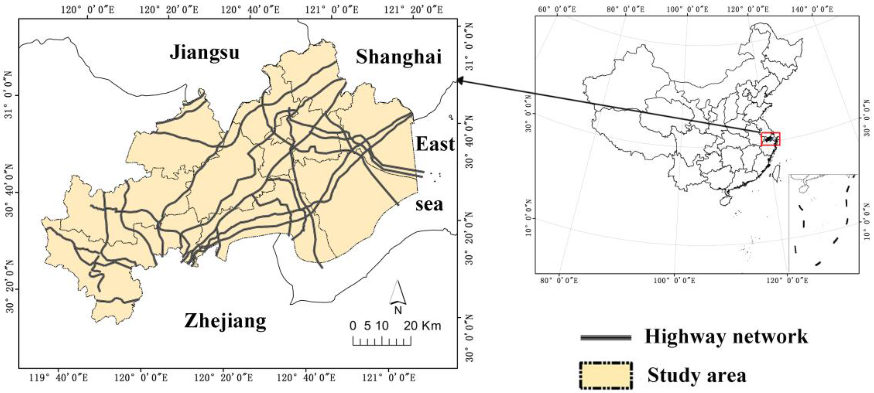
This study concentrated on the Hang-Jia-Hu Plain, which covers 7785 km
2 in northern Zhengjiang Province (
Figure 1). It is flat, watery land that is famous for its long history of agricultural civilization. The major soil type is paddy soil. It has a subtropical monsoon climate with an average annual temperature of 17.5 °C and an annual rainfall of approximately 1139 mm. Superior natural conditions are beneficial for agricultural production. Rice, fish and silkworm cocoons are the major agricultural products of the Hang-Jia-Hu Plain.
Historically, the Hang-Jia-Hu Plain is one of the developed traffic areas, as the Grand Canal from Beijing to Hangzhou crosses this plain. Since the “National Trunk Highway System planning” in 1993, it has become a crucial transport hub in eastern coastal China, connecting the most developed areas, Zhejiang Province, Shanghai and Jiangsu Province, and also connecting the Shanghai port and Ningbo-Zhoushan port, two of the most significant ports in the world. According to the latest national surveys, the Hang-Jia-Hu Plain has experienced unprecedented economic development and highway construction during the last two decades, and GDP increased from 12.44 billion yuan to 339.78 billion yuan; the mileage of highway increased from 206.7 km to 1952.2 km. However, rapid highway construction directly and indirectly induced developed land expansion associated with farmland loss, leading to a serious problem for sustainable regional development. With the current boom in logistics, the increased requirements for highway construction will cause more serious conflicts between urban expansion and farmland loss in this region.
2.2. Database and Pro-Processing
The data sources utilized in this study are listed as follows: (1) digital land use maps for the years 1990, 2000 and 2010 were provided by the Chinese Ministry of Environmental Protection. The land-use information was extracted from remote sensing data by visual interpretation and field surveys with a validated overall accuracy of 84%. The final land-use dataset was classified into (1) four categories: built-up land, farmland (paddy field, dry land, aquaculture land and plantation), forest and water body (ponds, rivers and reservoirs); (2) Landsat TM images with a spatial resolution of 30 m were acquired in 1990, 2000 and 2010, which were downloaded from the U.S. Geological Survey’s (USGS) Global Visualization Viewer; (3) digital highway network data from the Hang-Jia-Hu Plain were obtained from the Zhejiang Highway Management Bureau, with the assistance of Google Earth images. In this study, we referred to the highway network consisting of national highways and provincial highways, which had speeds of more than 60 km/h, and all highways were divided into two types to represent different capacities of traffic: the non-expressway and expressway (speed: 60 km/h < non-expressway < 80 km/h, 80 km/h < expressway < 120 km/h; traffic flow: 5000 cars/day < non-expressway < 25,000 cars/day, expressway > 25,000 cars/day; access control: non-expressway did not have access control with signalized intersections, expressways had full access control without signalized intersections; charge or not: non-expressway was free, expressway was not free); and (4) demographic and socio-economic data in 1990, 2000 and 2010 were derived from the local statistical bureau (1990–2011).
2.3. Highway Density
Many empirical studies have confirmed the causality between construction of highways and local development [
25,
26]. The highway density index can be used to reflect the urbanization process and the prosperity of the economy and population [
17,
19]. The highway density index (HDI) is designed to trace changes in highway infrastructure over time in the Hang-Jia-Hu Plain and is defined as:
where
(km/100 km
2) is the highway density per area in year t;
(km/person) is the highway density per capita in year t;
(km) is the total length of highway in year t;
is the total area of the Hang-Jia-Hu Plain; and
is the total population of the Hang-Jia-Hu Plain at time t.
2.4. Spatial Patterns Analysis
2.4.1. Landscape Metrics
Within the context of eco-environmental impact, construction of highways induces land-use change directly and indirectly [
4]. These impacts change the structure of the landscape and cause many adverse consequences, such as loss of biodiversity and soil and water pollution [
27,
28]. Landscape metrics are useful in measuring the detailed spatial information and dynamic patterns [
29,
30].
In our study, direct impact and indirect impact were measured. Direct impact only considered the landscape occupation caused by highway construction, and ignored the land-use changes within the highways effect zone (0–2000 m) during the study period. Based on the land-use in 1990, we assumed the landscape within the highways effect zone (0–2000 m) was not changed in 2000 and 2010. Then, the landscape metrics were calculated to analyze the direct impact of the highways. In contrast, indirect impact reflects the land-use change within the highways effect zone (0–2000 m) induced by the highways.
A large set of metrics has been developed to describe the spatiotemporal patterns of land-use structure influenced by highways [
31,
32]. Considering the ecological implication of the various metrics and eliminating redundancy, we selected four landscape metrics for the regional level (
Table 1): patch density (PD), landscape shape index (LSI), mean Euclidean nearest neighbor distance (ENND) and Shannon’s diversity index (SHDI). These metrics reflect the density, structural spatial pattern, connectivity and diversity of the regional landscape. These indicators were calculated in FRAGSTATS 4.2 software [
33].
2.4.2. Dynamic Analysis of Land-Use Change
The road-effect zone serves as a common analysis unit to evaluate the influence of transport activities on the natural environment or social economy [
34,
35]. In this study, buffer analysis was employed to monitor the spatial variance of landscape pattern changes in the highway-effect zone [
35,
36]. However, no standard exists for determining the highway-effect zone, and correlative studies have proved that the effect of highway on land use change was extended over 1 km [
34,
37]. Considering the rapid urbanization process and the topological characteristics in the Hang-Jia-Hu plain, we defined the area that was 2 km to each side away from the highway as the highway-effect zone. To make the results comparable and reliable, the width of the highway was considered to be 30 m based on the Highway Engineering Technique Standard (JT/GB01-2014). The dynamic land-use changes between 1990 and 2010 were detected for the highway-effect zone.
2.4.3. Land Development Intensity (LDI)
The land development intensity is an important indicator to reflect the level of sustainable land utilization for a region [
38]. According to the planning of national development priority zones [
39], the land development intensity is presented as the ratio of built-up area to total land area.
The Land Development Intensity (LDI) is described in Equation (3).
where
is the land development intensity of spatial unit i, year t;
represents the area of built-up land within spatial unit i, year t; and
is the total area of spatial unit i, year t.
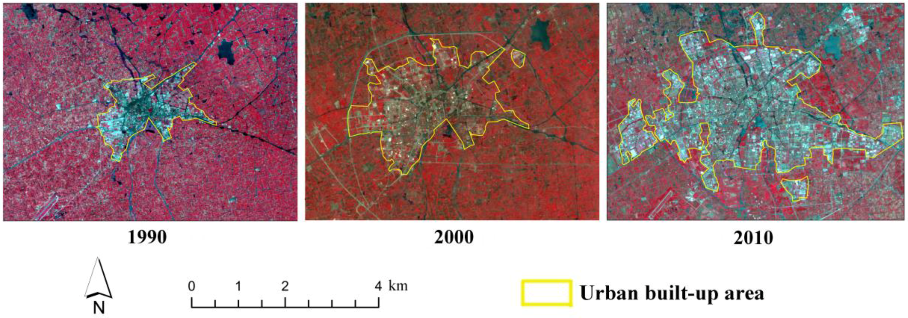
In this study, we defined the urban built-up area based on China’s Standards for Basic Terminology of Urban Planning [
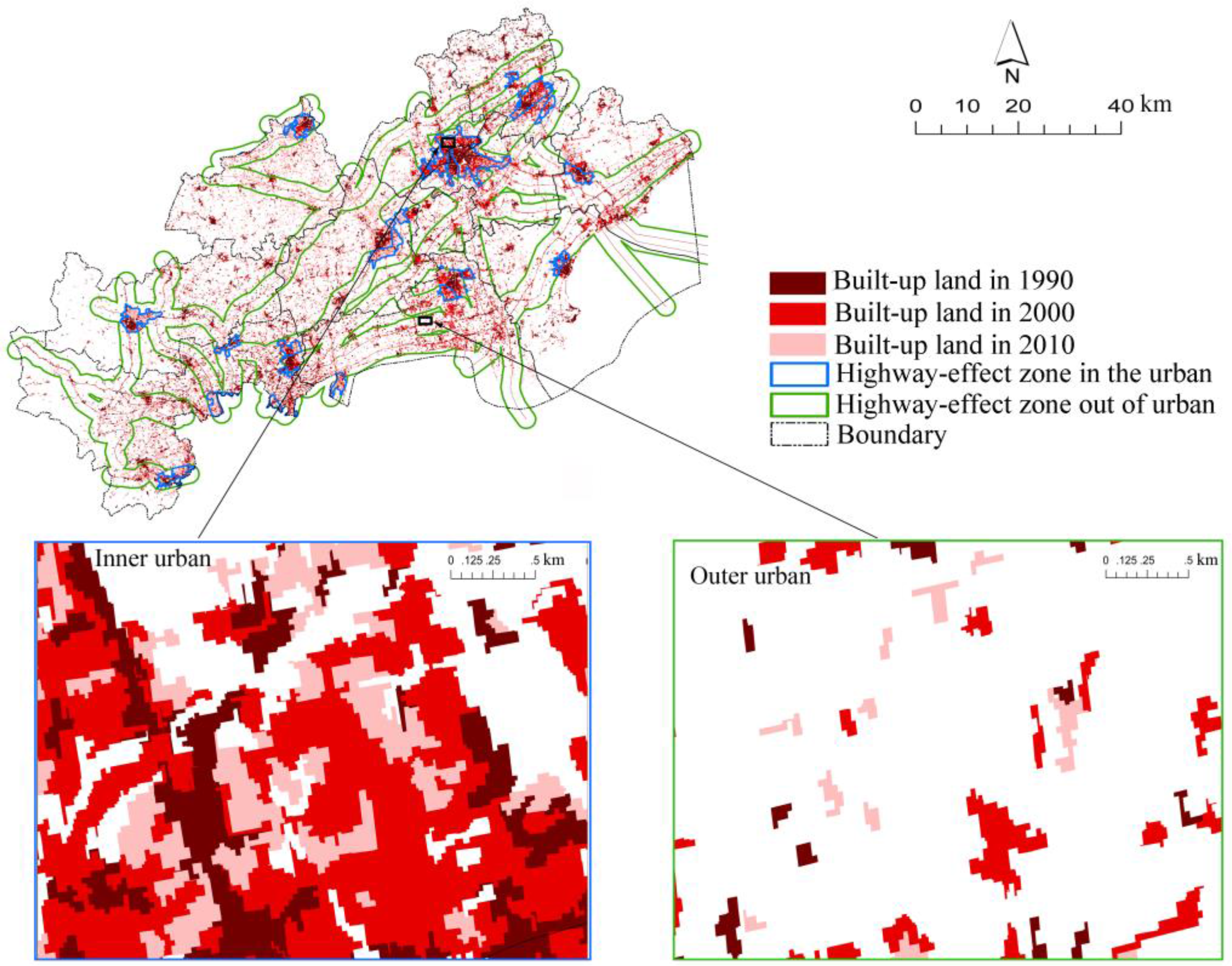
40]. The scope of an urban built-up area is determined by the contiguous built-up land without mountains, extremely large rivers, lakes and large-scale ecological conservation regions. We depict an artificial interpretation of remote-sensing images to obtain the urban built-up area for the years 1990, 2000, and 2010. An example of the depicted urban built-up area was exhibited in
Figure 2. In our study, the LDI was calculated for the highway-effect zone within the urban built-up area and outside of the urban built-up area.
2.4.4. Expansion Intensity Index (EII)
The EII provides a quantitative approach to indicate the spatiotemporal dynamics of built-up land expansion and is significantly correlated with other widely used urbanization indices, such as population density and percentage of imperviousness [
41]. This index was used to assess the impact of expressway and non-expressway highways across the two time periods. To identify the trends of built-up land growth processes, the highway-effect zone was divided into 10 intervals of 0.2 km each (both sides), from 0 to 2000 m, and EII was measured in each belt.
The EII is defined as follows:
where
is the urban expansion intensity in the buffer i;
and
are the urban area in the target buffer in year t + n and year t, respectively; n is the interval of the calculation period (in years); and
is the total area of spatial unit i.
3. Results
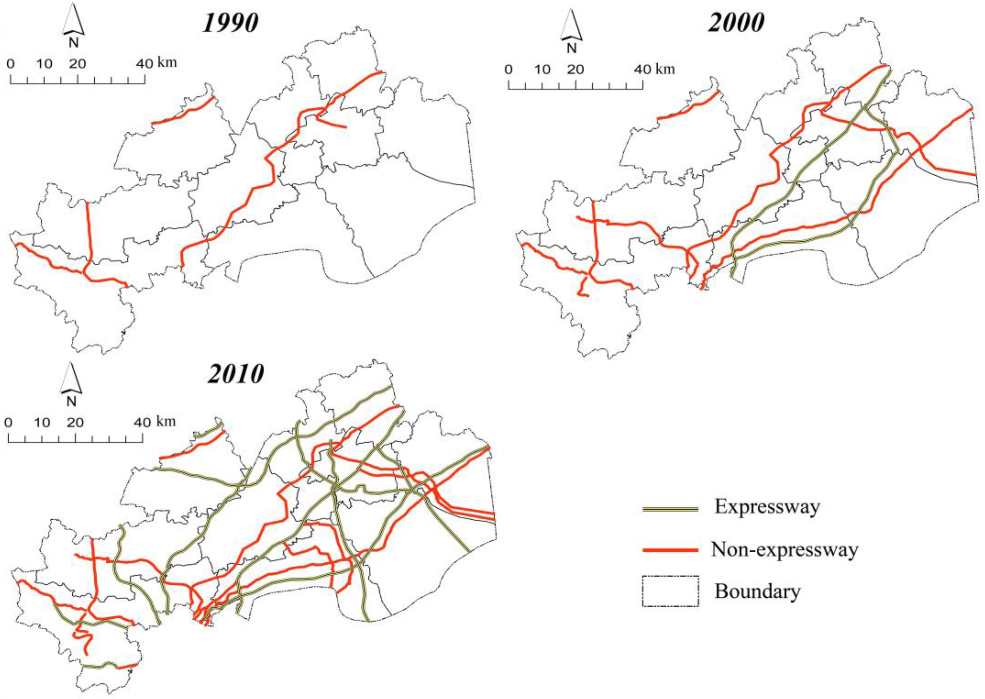
3.1. Dynamic Changes of Highway Density
The synoptic analysis of highway density provided evidence of growth over the last two decades, and the growth of highway density per capita was slower than highway density per area (
Table 2). The most significant changes occurred on expressways between 2000 and 2010, when the expressway density per area increased from 1.39 km/100 km
2 to 6.67 km/100 km
2, and the expressway density per capita increased more than 4-fold. The sparse spatial patterns of highway develop into a dense network from 1990 to 2010 (
Figure 3).
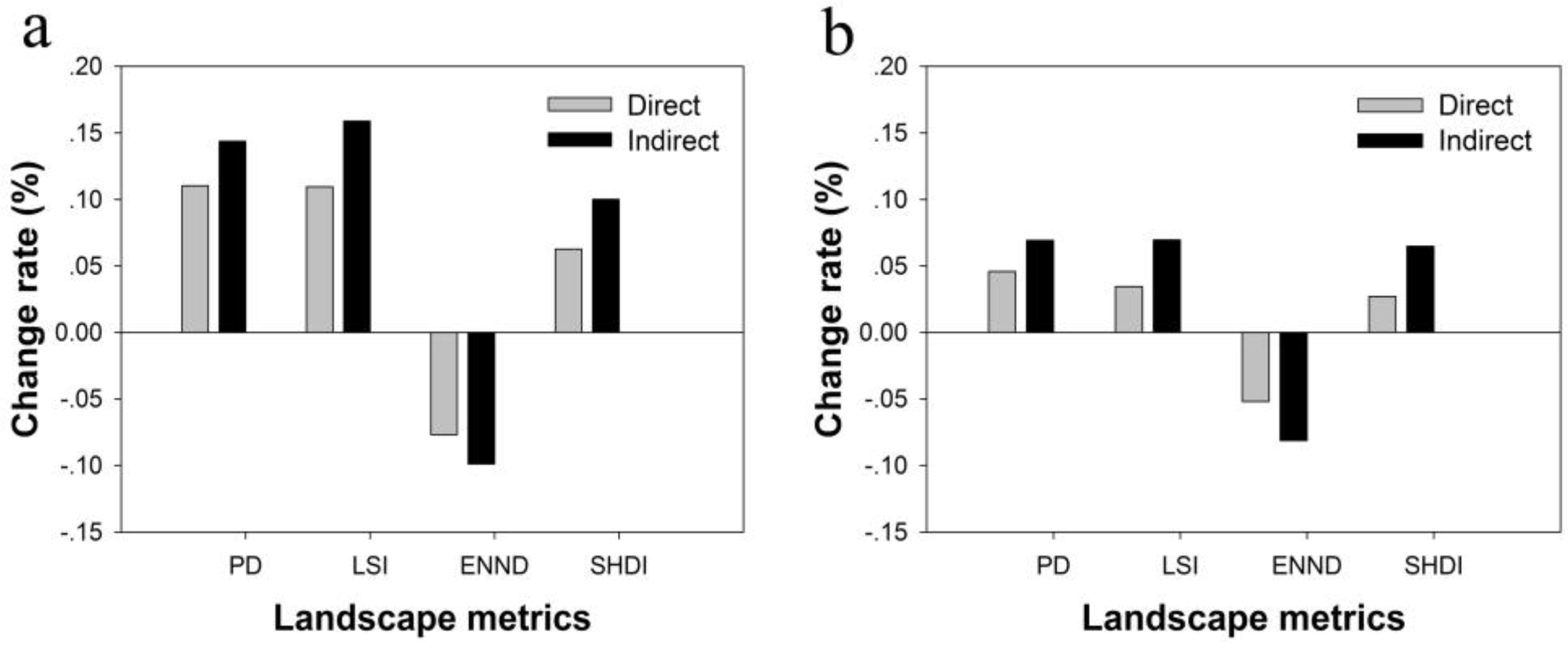
3.2. Direct and Indirect Impact on Landscape Patterns Caused by Highway Construction
Highway construction has directly fragmented the landscape in the Hang-Jia-Hu Plain, creating edge habitat, altering stream and wetland drainage, and obstructing gene flow [
42]. However, the newly developed land accessible by highway not only formed numerous scattered patches but also more irregular shapes, increasing the human disturbance to this area. Intensive human activities interfere with fitness of plant and animal populations, ecosystem resilience and ecosystem services’ efficiency [
43,
44]. Our result indicates that compared with the direct impact of highway construction, the indirect impact gives the landscape more complex edges, a more irregular shape, less connectivity and more diversity, evidenced by the higher values of PD, LSI and SHDI and lower values of ENND (
Figure 4). Moreover, the deterioration of the landscape in the second period (2000–2010) was less severe than that in the first period (1990–2000). On the whole, the deterioration of the landscape pattern was mitigated over the period 2000 to 2010, mainly due to improved regulation and laws that controlled the accelerated expansion of built-up land.
3.3. Pattern Changes Induced by Indirect Impact of Highway Construction
3.3.1. Land-Use Changes in the Highway-Effect Zone
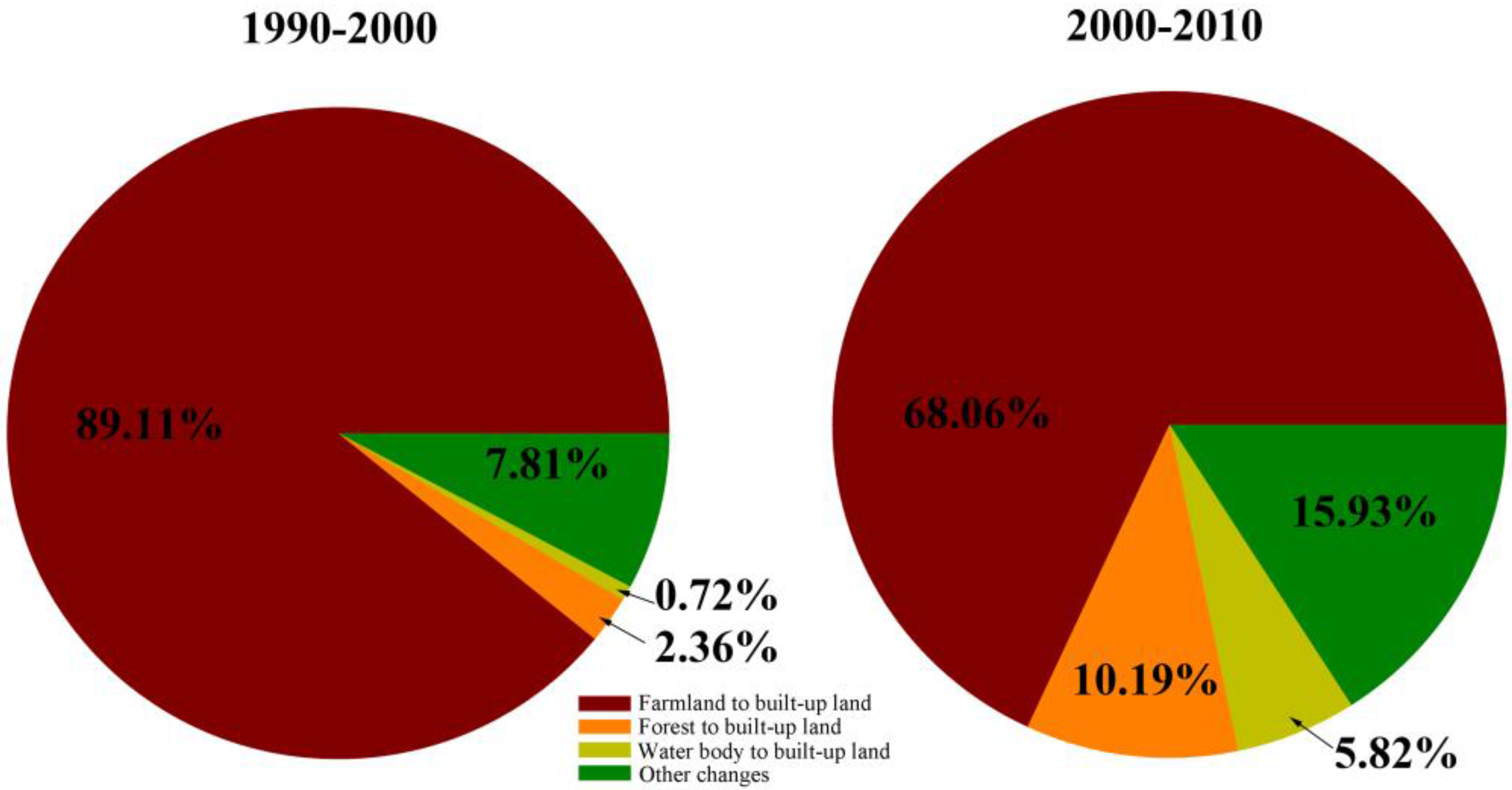
Built-up land expansion that covered farmland, forest and water bodies was a major component of land-use change in the highway-effect zone (
Figure 5), contributing to 87.16% of the total change area during the last two decades. Among the three types, the largest transition occurred on farmland. In the first period (1990–2000), 276.1 km
2 of farmland was converted to built-up land, which was 89.11% of the total change in the area. However, the transition proportion decreased to 68.06% during 2000 to 2010. Meanwhile, the proportion of land that was converted from forest and water bodies to built-up land increased from 3.08% to 16.01%. Smaller areas were changed from farmland to forest, water bodies to farmland and so on; and we combined them to “other changes”. Paddy fields are the dominant type of farmland in this area, and they provide rice production as well as multiple environmental functions to ameliorate the environmental effects of urbanization such as local climate mitigation, groundwater recharge, purifying the air, and so on [
13]. However, the full range of environmental functions will be lost when they are converted to built-up land.
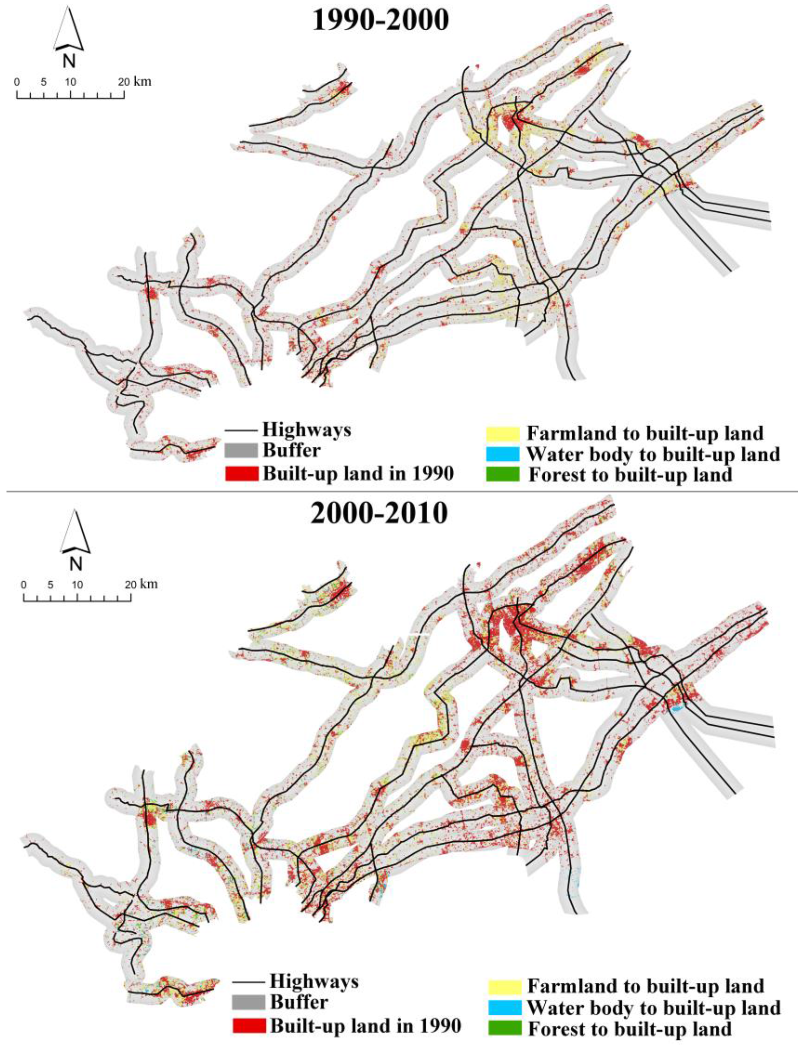
The spatial distribution of built-up land growth (
Figure 6) allowed us to identify the expansion patterns induced by highway construction and to recommend proper policies. Our study found that, from 1990 to 2000, the built-up land expansion first occurred around the original urban core. Additionally, a larger area of farmland was lost in the northeast region that was closer to Shanghai. From 2000 to 2010, a large amount of farmland was replaced by built-up land away from the urban center. These results indicate that the farmlands located in the urban fringe and near the highways were the primary victims, and serious farmland loss initially occurred in the urban areas and then spread to the rural regions.
3.3.2. Expansion Patterns of Built-Up Land in Urban and Out of Urban Areas
To further illustrate the impact on the landscape structure of built-up land expansion, the land development intensity (LDI) in the highway-effect zone was calculated in the urban and out-of-urban areas in 1990, 2000 and 2010 (
Table 3). The LDI of the inner urban area had considerable growth between 1990 and 2000, but barely increased from 2000 to 2010, suggesting that the built-up land in the urban area becomes saturated and that the intense expansion occurred outside of the urban area after 2000.
Figure 7 showed the expansion pattern of built-up land in the urban and out-of-urban areas. In the highway-effect zone of the inner urban area, the expansion pattern of development was continuous; on the contrary, the expansion pattern of development was mainly discontinuous in the highway-effect zone of the outer urban area.
3.3.3. Spatiotemporal Patterns of Built-Up Land Growth in the Highway-Effect Zone
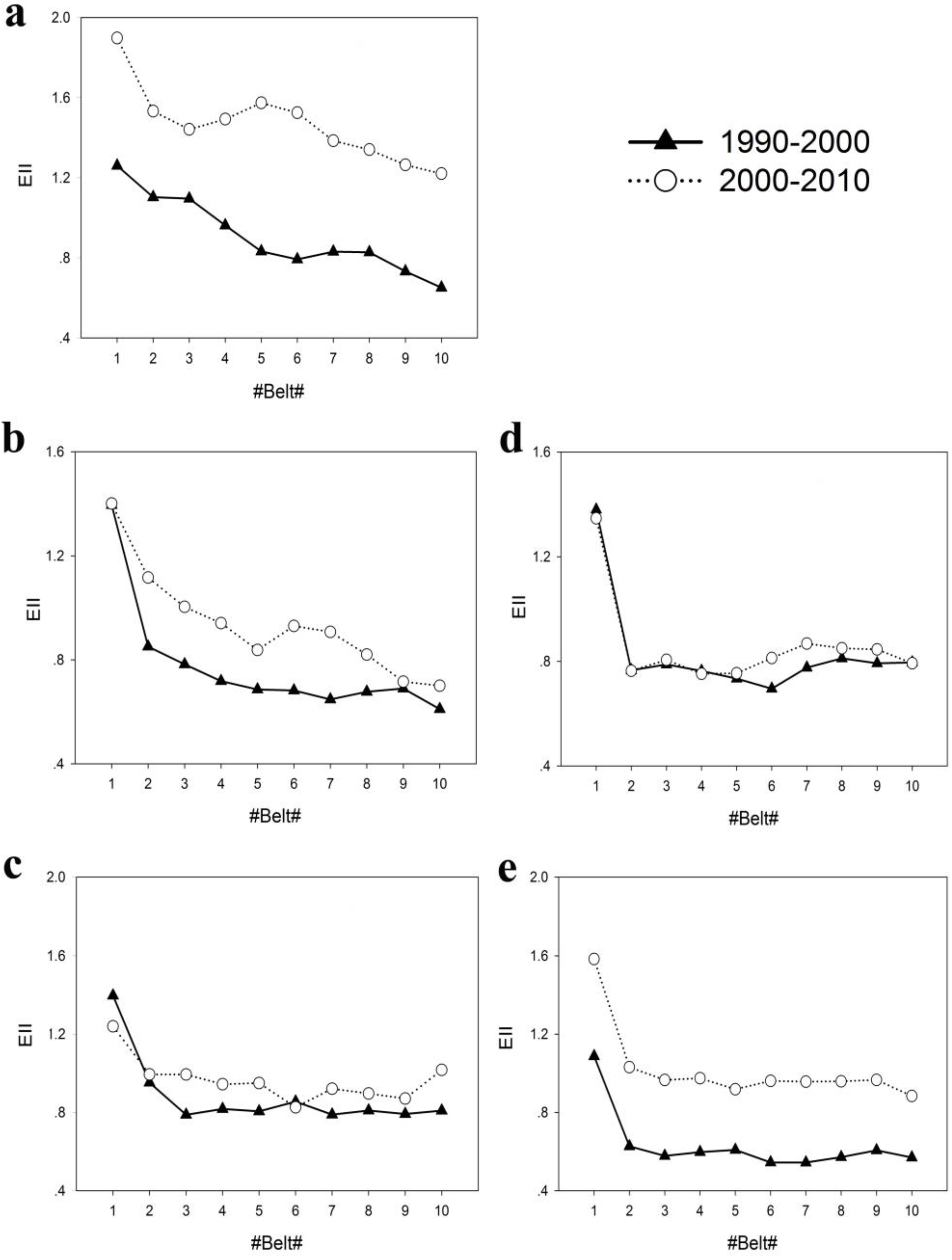
Expressway and non-expressway areas exhibited different characteristics of land attraction. Between 1990 and 2000, the EII peaked at belt 1 and decreased with an increase in buffer distance for non-expressway and expressway areas (
Figure 8). More specifically, significant declining trends were detected in belts 1–2. For both non-expressway and expressway areas, the EII from 2000 to 2010 gradually increased based on the values between 1990 and 2000. After belt 2, ΔEII went through the pattern of going from small to large in each figure. These results confirmed that the dramatic expansion of built-up land occurred in belt 1, and the fast growth area of built-up land gradually shifted outward from the sides of the highways.
The contrast between
Figure 8a,b and
Figure 8c showed that the change of EII along the non-expressway area gradually declined. On the contrary, the change of EII along the expressway area gradually increased, as indicated by comparing
Figure 8d and
Figure 8e. The changes revealed that construction of expressways attracted more and more built-up land and induced a large amount of land transition.
4. Discussion
4.1. Highway Development under Rapid Urbanization
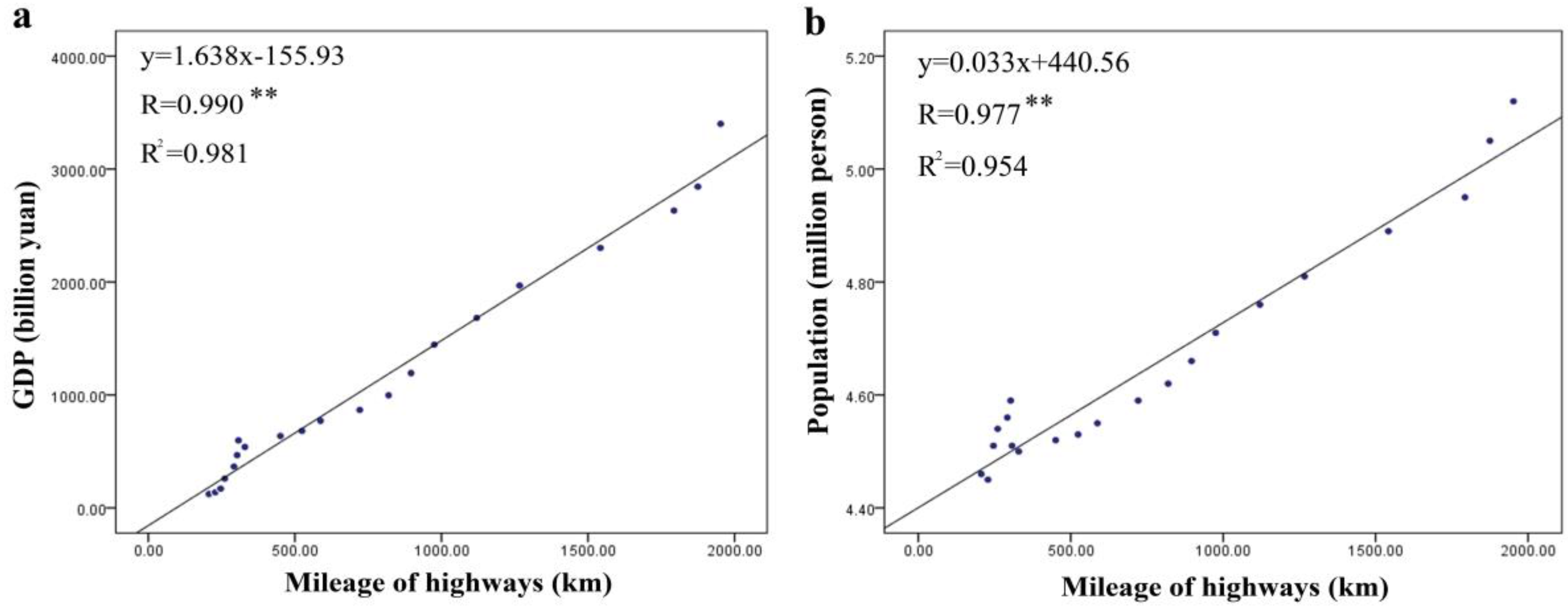
Highway density per area of the Hang-Jia-Hu Plain increased by more than 12-fold, and highway density per capita increased approximately six-fold. The highway density far exceeded the level of a developed country by the end of 2010, especially the expressway density [
45]. Several studies have shown that interactive circular feedback relationships exist between the transportation system, local economic development and population [
18,
25,
28,
31,
46]. The construction of highways will increase the regional accessibility and enhance human activities along the transportation routes. Consequently, a convenient highway system attracts new commercial and real estate projects that lead to a boom of economic development and population. With the improvement in quality of life, travel demand increases, which, in turn, promotes the extension and improvement of the transport network. As expected, we found that GDP and population had a strong relationship with mileage of highway in these two periods (
Figure 9). Since “the Opening-Up Policy” in 1978, the Hang-Jia-Hu Plain has been a priority for development; however, a less developed highway system restricted local development until the early 1990s. To keep pace with economic development, the local government implemented powerful strategies to improve highway conditions and decided to construct the first expressway in Zhejiang Province in 1996. In 1998, the local government decided to establish a “four-hour highway traffic circle” to access the 11 prefecture cities in Zhejiang Province. Meanwhile, the expressway from Shanghai to Hangzhou, which was the first expressway in the study area, was opened to traffic. Since then, construction of expressways has entered a rapid developmental period (
Table 2).
The accelerated construction of highways can also stimulate built-up land expansion along highway corridors and has become the major driving force of urban growth [
47,
48]. In a previous study, we detected that the urbanized areas increased from 501.02 km
2 in 1990 to 1616.22 km
2 in 2010 [
14], with a net increase of 1115.20 km
2; however, 62.96% of the newly developed land was in highway-effect zones. Highways across the Hang-Jia-Hu Plain have created a new spatial framework for regional development. Highways passed through the urban fringe to connect the developing centers and induced the growth of the adjacent underdeveloped areas [
4]. Thus, large-scale industrial park and real estate projects were drawn to the peri-urban areas, and small-scale human settlements and private enterprise, previously located in the rural region, developed to seek lower transportation costs and more convenience [
49].
4.2. Spatial Features of Farmland Loss Associated with Highway Construction
Within the context of eco-environmental conservation, highway construction that fosters economic or population growth induces direct and indirect changes in landscape patterns [
4]. Our study suggests the indirect land-use changes induced by highway construction had a greater impact on the regional landscape pattern. Several studies have also found that greater land-use change takes place in proximity to the highway [
4,
27]. In the last two decades, former farmland accounted for 76.07% of the total area of new built-up land induced by the indirect impact of highways. Our results support the idea that human settlement easily encroaches on farmland because settlements are generally located in the well-drained plain areas of cities or transportation systems [
34,
37,
48]. However, the dramatic reduction of farmland, bringing an end to the land’s long tillage history and eco-environmental supportive functions, threatens the food supply security and the sustainability of the study area. Additionally, destruction of the farmland structure can also result in eco-environmental deterioration. For example, the direct impact of highway construction has isolated farmland patches and created barriers to energy flows in agro-ecosystems [
36], and the indirect impact of highway construction has fragmented farmland and increased the potential risks of pest infestation and erosion [
49].
Due to the advantageous geographical conditions and developmental policy, built-up land expansion has been an inevitable consequence of the rapid urbanization process in the Hang-Jia-Hu Plain. At the beginning of the 1990s, substantial land acquisition and land leasing attracted investments to drive high economic growth and employment. With the development of the highway system, intense urban growth first occurred in the urban fringe, where the urban boundary sprawled dramatically between 1990 and 2000. After 2000, prosperous e-commerce and logistics gave rise to many small-scale private enterprises in the Hang-Jia-Hu Plain. These enterprises prefer to be located away from the urban area but near highways for more convenience and lower costs. Our results indicate that three common urban growth types (infilling, outlying and edge-expansion) [
50,
51] have been widely observed in the newly developed urban areas, and infilling and edge-expansion have also been detected. Consequently, a large amount of contiguous farmland was lost to built-up land in the urban area. In contrast, outlying growth was poorly interspersed among farmland patches in the rural region, which also contributed to the increased fragmentation and instability of the farmland.
The highway’s impact on the EII relied on the distance, time and the route type. Similar results were found for Shenzhen: the expansion of developed land broadened along with the increase of highway buffers in the urban areas [
52]. Generally, the strongest land development occurred nearest the highway where the expansion area becomes larger and turns into a more continuous simple structure; however, the scattered settlements increased as the distance increased [
28]. Thus, farmland can easily become unstable after strong expansion. Moreover, comparing the EII at the same distance, it can be observed that the land absorption along expressways was more significant than along non-expressways. Tsou also proved that the upper-level highways influenced the local development pattern more seriously in Taiwan [
53]. These results indicate that the farmland located in the expressway-effect zone face higher risk of disruption.
4.3. Implications of Farmland Protection Policy on Highway’s Impact
In the Hang-Jia-Hu Plain, the proportion of farmland transition in the highway-effect zone in the 1990–2000 period was much higher than that in the 2000–2010 period. This change was mainly attributed to a series of land policy reforms at the beginning of the 1990s. After the planning system was replaced by a market economy in 1993, increasing foreign investment accelerated the pace of urbanization in China. With the implementation of fiscal decentralization, local government pursued economic development by land leasing and charging. Meanwhile, the Ministry of Communications (MC) decided to construct the National Trunk Highway System in 1993 to keep pace with the rapid economic development. Since then, the cities with good accessibility had higher probabilities of losing farmland [
11]. However, the excessive loss of farmland was slowed by the “Ordinance for the Protection of Primary Agricultural Land” in 1994 and the revised Land Act in 1998 [
10,
11,
54]. Our results suggest that these farmland protection policies prevented the built-up land conversion from farmland in 2000–2010. Similar to the Pearl River Delta region, the urban expansion rate came down in 2003–2008 [
55]. Increasing requirements of highway construction due to the development of e-commerce and logistics will further intensify the land-use conflicts between built-up land and farmland. Therefore, farmland will continue to be threatened by highway construction.
Although the percentage of built-up land converted from farmland decreased over the period 2000–2010, we found that the newly developed area was always distributed in the rural area near highways. Two possible reasons may explain this phenomenon: (1) after 2000, many industries transferred to rural regions for cheap land and labor, where local economic development and population growth then increased the demands for highway construction; and (2) rural farmland near the highway attracted businesses due to the locations’ convenience and lower land prices; thus, local governments were compelled to transform the farmland to non-agricultural land for local economic development. Such a situation was also detected in the Su-Xi-Chang region [
12] and Wuhan of China [
56]. This rural region problem caught the attention of the central government. The land-use strategy of “increasing
vs. decreasing balance” was proposed by the Ministry of Land and Resources (MLR) in 2005 and implemented in 2010. The key objective of this land use policy is to achieve equilibrium between increased urban built-up land and decreased rural built-up land. Consequently, the former rural built-up land could be reclaimed or consolidated as farmland to supply the reduction of farmland during the urbanization process [
57]. Additionally, the Ministry of Land and Resources (MLR) declared transfer of the prime farmland construction to permanent prime farmland to forbid all kinds of occupation on prime farmland from 2014 [
58]. However, poor coordination between urban planning, economic development planning and land use planning created an obstacle for implementing the land use planning successfully [
55]. Therefore, the system of land use management should be addressed to reconcile contradictions of different development planning and formulate an excellent set of rules to maintain the sustainable development of rural regions.
Additionally, these strict farmland protection policies will contribute to the prevention of total farmland loss. However, the cohesive agricultural landscape is still fragmented by the direct and indirect impacts of highway construction, especially in the expressway areas, due to the lack of integrated planning for the spatial pattern of farmland. Scattered farmland interferes with agricultural mechanization for large-scale operations that could help to improve efficiency and the quantity of grain production [
59]. In addition, in considering the ecological consequences associated with farmland loss, an overall farmland protection system should be built to enhance spatial control and mitigate the adverse impacts caused by highway construction.
5. Conclusions
China has witnessed increasing land-use conflict between built-up land growth and farmland loss. Although many reports have tried to explain this problem in urban or rural regions, few researchers have focused on the interaction between highway impact and farmland loss. Our study has attempted to fill this research gap by analyzing the direct and indirect impacts of highway construction and the form and location of the associated farmland loss. Based on GIS spatial analysis, remote sensing, buffer analyses and landscape metrics, we analyzed the landscape pattern changes caused by direct and indirect highway impacts, and we also explored the relationship between farmland loss and highway construction. Finally, the implications of farmland protection policy were discussed.
The results revealed that a dense highway network was built in the Hang-Jia-Hu Plain during the last two decades, and the development of expressways has accelerated since 2000. However, due to the farmland protection policies imposed in the 1990s, the proportion of new built-up land converted from farmland decreased to 68.06% from 2000 to 2010. In addition, serious farmland loss initially occurred in the urban area and then spread to the rural region. In the highway-effect zone, infilling and edge-expansion growth of built-up land led to a large amount of continuous farmland loss, and outlying growth of built-up land scattered the farmland, especially in the rural region. The highways’ impact associated with farmland loss relied on the distance, time and route type. Our results suggest that the impact of highways on farmland loss increased with the time and with the distance away from highways. Additionally, the farmland located in the expressway-effect zone faced higher risk of disruption.
In summary, farmland protection policies mitigated the pace of built-up land converted from farmland induced by highway construction. Due to the confused farmland protection system and unreasonable management, there are still large gaps in efficient farmland protection and regional sustainable development. Central and local governments should address reconciling contradictions in different development planning to establish an overall farmland protection system and enhance spatial control in mitigating the adverse impacts caused by highway construction.
However, with the increasing requirements of highway construction due to the development of e-commerce and logistics, the Hang-Jia-Hu Plain will certainly experience intense highway construction that will induce serious land-use conflicts between built-up land growth and farmland loss. The results are expected to provide a scientific basis for an integrated farmland protection system for the economical and intensive use of land. Moreover, the comprehensive approach integrating GIS, landscape metrics, and buffer analysis are demonstrated as a rational tool to study the impacts of highway construction on farmland loss. Further studies should formulate recommendations that will be helpful for regional sustainability by integrating future transportation planning, modeling possible future land-use types near transportation routes, and evaluating the ecological consequences of highway construction on farmland.
Acknowledgments
This research was funded by the National Science-technology Support Projects (No. 2015BAC02B06), Ministry of Land and Resource (No. 20141119) and the Chinese Ministry of Environmental Protection (No. STSN-05-11). The authors thank Editor Shirley Zhou, Academic Editors Qiming Zhou, Zhilin Li and Wolfgang Kainz and three anonymous reviewers for their constructive comments, suggestions and help in enhancing the manuscript.
Author Contributions
Jie Song, Ke Wang, and Jinsong Deng had the original idea for the study and all coauthors conceived and designed the methodology. Jie Song and Jintian Ye analyzed the data. Jie Song wrote the paper, which was revised by Jinsong Deng and Ke Wang. All authors read and approved the final manuscript.
Conflicts of Interest
The authors declare no conflict of interest.
References
- National Trunk Highway System Planning. Available online: http://www.mot.gov.cn/lishizhibohuigu/gaigekaifang_GL/xiangguanlianjie/201512/t20151225_1964060.html (accessed on 22 March 2016).
- The National Highway Network Planning (2013–2030). Available online: http://zfxxgk.ndrc.gov.cn/PublicItemView.aspx?ItemID={93c7d13b-aa0d-4beb-955e-268adade8a8f} (accessed on 27 March 2016).
- Lichtenberg, E.; Ding, C. Local official as land developers: Urban spatial expansion in China. J. Urban Econ. 2008, 66, 57–64. [Google Scholar] [CrossRef]
- James, K.L.; Karis, L.D. Assessing the growth-inducing impact of the Appalachian Development Highway System in southern Ohio: Did policy promote change? Land Use Policy 2008, 25, 523–532. [Google Scholar]
- Chen, J. Rapid urbanization in China: A real challenge to soil protection and food security. Catena 2007, 69, 1–15. [Google Scholar] [CrossRef]
- Kalnay, E.; Cai, M. Impact of urbanization and land-use change on climate. Nature 2003, 423, 528–531. [Google Scholar] [CrossRef] [PubMed]
- Batisani, N.; Yarnal, B. Urban expansion in Centre County, Pennsylvania: Spatial dynamics and landscape transformations. Appl. Geogr. 2009, 29, 235–249. [Google Scholar] [CrossRef]
- Pijanowski, B.C.; Ray, D.K. Rates and patterns of land use change in the Upper Great Lakes States, USA: A framework for spatial temporal analysis. Landsc. Urban Plan. 2011, 102, 102–116. [Google Scholar] [CrossRef]
- Martellozzo, F. Forecasting high correlation transition of agricultural landscapes into urban areas: diachronic case study in north eastern Italy. Int. J. Agric. Environ. Inf. Syst. (IJAEIS) 2012, 3, 22–34. [Google Scholar] [CrossRef]
- Tan, M.; Li, X.; Xie, H.; Lu, C. Urban land expansion and arable land loss in China—A case study of Beijing-Tianjin-Hebei region. Land Use Policy 2005, 22, 187–196. [Google Scholar] [CrossRef]
- Li, X.; Yeh, A.G.-O. Analyzing spatial restructuring of land use patterns in a fast growing region using remote sensing and GIS. Landsc. Urban Plan. 2004, 69, 335–354. [Google Scholar] [CrossRef]
- Long, H.; Liu, Y.; Wu, X.; Dong, G. Spatio-temporal dynamic patterns of farmland and rural settlements in Su-Xi-Chang region: Implications for building a new countryside in coastal China. Land Use Policy 2009, 26, 322–333. [Google Scholar] [CrossRef]
- Natuhara, Y. Ecosystem services by paddy fields as substitutes of natural wetlands in Japan. Ecol. Eng. 2013, 56, 97–106. [Google Scholar] [CrossRef]
- Song, J.; Cai, D.; Deng, J.; Wang, K.; Shen, Z. Dynamics of paddy field patterns in response to urbanization: A case study of the Hang-Jia-Hu Plain. Sustainability 2015, 7, 13813–13835. [Google Scholar] [CrossRef]
- Furberg, D.; Ban, Y.F. Satellite monitoring of urban sprawl and assessment of its potential environmental impact in the Greater Toronto Area between 1985 and 2005. Environ. Manag. 2012, 50, 1068–1088. [Google Scholar] [CrossRef] [PubMed]
- Ji, W.; Wang, Y.; Zhuang, D.F.; Song, D.P.; Shen, X.; Wang, W.; Li, G. Spatial and temporal distribution of expressway and its relationships to land cover and population: A case study of Beijing, China. Trans. Res. Part D 2014, 32, 86–96. [Google Scholar] [CrossRef]
- Aljoufie, M.; Zuidgeest, M.; Brussel, M.; Maarseveen, M.V. Spatial-temporal analysis of urban growth and transportation in Jeddah City, Saudi Arabia. Cities 2013, 31, 57–68. [Google Scholar] [CrossRef]
- Amato, F.; Maimone, B.; Martellozzo, F.; Nolè, G.; Murgante, B. The effects of urban policies on the development of urban areas. Sustainability 2016, 8. [Google Scholar] [CrossRef] [Green Version]
- Amato, F.; Pontrandolfi, P.; Murgante, B. Supporting planning activities with the assessment and the prediction of urban sprawl using spatio-temporal analysis. Ecol. Inf. 2015, 30, 365–378. [Google Scholar] [CrossRef]
- Ratner, K.A.; Goetz, A.R. The reshaping of land use and urban form in Denver through transit-oriented development. Cities 2013, 30, 31–46. [Google Scholar] [CrossRef]
- Müller, K.; Steinmeier, C.; Küchler, M. Urban growth along motorways in Switzerland. Landsc. Urban Plan. 2010, 98, 3–12. [Google Scholar] [CrossRef]
- Miriam, S.; Luis, S.; Jordi, P.; Juanjo, P. Landscape fragmentation caused by the transport network in Navarra (Spain) Two-scale analysis and landscape integration assessment. Landsc. Urban Plan. 2002, 58, 113–123. [Google Scholar]
- Zhu, M.; Xu, J.G.; Jiang, N.; Li, J.L.; Fan, Y.M. Impacts of road corridors on urban landscape pattern: A gradient analysis with changing grain size in Shanghai, China. Landscape. Ecol. 2006, 21, 723–734. [Google Scholar] [CrossRef]
- Won, S.H.; Cho, S.E.; Kim, S.H. The neighborhood effects of new road infrastructure: Transformation of urban settlements and resident’s socioeconomic characteristics in Danang, Vietnam. Habitat. Int. 2015, 50, 169–179. [Google Scholar] [CrossRef]
- Bryan, J.; Hill, S.; Munday, M.; Roberts, A. Road infrastructure and economic development in the periphery: The case of A55 improvements in North Wales. J. Transp. Geogr. 1997, 5, 227–237. [Google Scholar] [CrossRef]
- Olsson, J. Improved road accessibility and indirect development effects: Evidence from rural Philippines. J. Transp. Geogr. 2009, 17, 476–483. [Google Scholar] [CrossRef]
- Seto, K.C.; Fragkias, M. Quantifying spatiotemporal patterns of urban land-use change in four cities of China with time series landscape metrics. Landsc. Ecol. 2005, 20, 871–888. [Google Scholar] [CrossRef]
- Wu, C.F.; Lin, Y.P.; Chiang, L.C.; Huang, T. Assessing highway’s impacts on landscape patterns and ecosystem services: A case study in Puli Township, Taiwan. Landsc. Urban Plan. 2014, 68, 67–71. [Google Scholar] [CrossRef]
- Deng, J.S.; Wang, K.; Hong, Y.; Qi, J.G. Spatio-temporal dynamics and evolution of land use change and landscape pattern in response to rapid urbanization. Landsc. Urban Plan. 2009, 92, 187–198. [Google Scholar] [CrossRef]
- O’Neill, R.V.; Krummel, J.R.; Gardner, R.H.; Sugihara, G.; Jackson, B.; DeAngelis, D.L.; Milne, B.T.; Turner, M.G.; Zygmunt, B.; Christensen, S.W.; et al. Indices of landscape pattern. Landsc. Ecol. 1988, 1, 153–162. [Google Scholar] [CrossRef]
- Tian, G.J.; Wu, J.G. Comparing urbanization patterns in Guangzhou of China and Phoenix of the USA: The influences of roads and rivers. Ecol. Indic. 2015, 51, 23–30. [Google Scholar] [CrossRef]
- Su, S.L.; Xiao, R.; Li, D.L.; Hu, Y.N. Impacts of Transportation routes on landscape diversity: A comparison of different route types and their combined effects. Environ. Manag. 2014, 53, 636–647. [Google Scholar] [CrossRef] [PubMed]
- McGarigal, K.; Cushman, S.A.; Neel, M.C.; Ene, E. FRAGSTATS: Spatial Pattern Analysis Program for Categorical Maps. Available online: www.umass.edu/landeco/research/fragstats/fragstats.html (accessed on 5 March 2016).
- Forman, R.T.T.; Deblinger, R.D. The ecological road-effect zone of a Massachusetts (U.S.A.) suburban highways. Conserv. Biol. 2000, 14, 36–64. [Google Scholar] [CrossRef]
- Romano, B.; Zullo, F. Landscape fragmentation in Italy. Indices implementation to support territorial policies. In Proceedings of the 7th International Conference on Informatics and Urban and Regional Planning, Cagliari, Italy, 10–12 May 2012; pp. 399–414.
- Saunders, S.C.; Mislivets, M.R.; Chen, J.; Cleland, D.T. Effects of roads on landscape structure within nested ecological units of the Northern Great Lakes Region, USA. Biol. Conserv. 2002, 103, 209–225. [Google Scholar] [CrossRef]
- Liu, S.; Cui, B.; Dong, S.; Yang, Z.; Yang, M.; Holt, K. Evaluating the influence of road networks on landscape and regional ecological risk—A case study in Lancang River Valley of Southwest China. Ecol. Eng. 2008, 34, 91–99. [Google Scholar] [CrossRef]
- Zhao, Y.L.; Liu, Y.Z. Diffidence and influencing factors of urban land development intensity across 222 cities in China. Resour. Sci. 2013, 35, 380–387. [Google Scholar]
- The Planning of National Development Priority Zones, 2010. Available online: http://www.gov.cn/zwgk/2011-06/08/content_1879180.htm (accessed on 12 November 2015).
- Ministry of Construction of P.R. China. China’s Standards for Basic Terminology of Urban Planning; China Architecture & Building Press: Beijing, China, 1999. (In Chinese) [Google Scholar]
- Tate, C.M.; Cuffney, T.F.; Mcmahon, G.; Giddings, E.M.P.; Coles, J.F.; Zappia, H. Use of an urban intensity index to assess urban effects on streams in three contrasting environmental settings. Am. Fish. Soc. Symp. 2005, 47, 291–315. [Google Scholar]
- Pierik, M.E.; Dell Acqua, M.; Confalonieri, R.; Bocchi, S.; Gomarasca, S. Designing ecological corridors in a fragmented landscape: A fuzzy approach to circuit connectivity analysis. Ecol. Indic. 2016, 67, 807–820. [Google Scholar] [CrossRef]
- Romano, B.; Ciabò, S.; Fabrizio, M. Infrastructure Obstruction Profiling: A method to analyse ecological barriers formed by transport infrastructure. In Proceedings of the 2011 International Conference on Ecology and Transportation, Seattle, WA, USA, 21–25 August 2011.
- Pelorosso, R.; Gobattoni, F.; Geri, F.; Monaco, R.; Leone, A. Evaluation of Ecosystem Services related to Bio-Energy Landscape Connectivity (BELC) for land use decision making across different planning scales. Ecol. Indic. 2016, 61, 114–129. [Google Scholar] [CrossRef]
- Li, S.J.; Tang, T.P. Analysis of Jiangsu province highway network density. J. Nantong Univ. (Nat. Sci. Ed.) 2013, 12, 60–63. (In Chinese) [Google Scholar]
- Kim, Y.J.; Han, H.J. Straw effects of new highway construction on local population and employment growth. Habitat. Int. 2016, 53, 123–132. [Google Scholar] [CrossRef]
- Hu, X.; Wang, W.; Sheng, H. Urban traffic flow prediction with variable cell transmission model. J. Transp. Syst. Eng. Inf. Technol. 2010, 10, 73–78. [Google Scholar] [CrossRef]
- Martellozzo, F.; Clarke, K.C. Measuring urban sprawl, coalescence, and dispersal: A case study of Pordenone, Italy. Environ. Plan. B 2011, 38, 1085–1104. [Google Scholar] [CrossRef]
- Su, S.; Jiang, Z.; Zhang, Q.; Zhang, Y. Transformation of agricultural landscapes under rapid urbanization: A threat to sustainability in Hang-Jia-Hu region, China. Appl. Geogr. 2011, 31, 439–449. [Google Scholar] [CrossRef]
- Wu, W.; Zhao, S.; Zhu, C.; Jiang, J. A comparative study of urban expansion in Beijing, Tianjin and Shijiazhuang over the past three decades. Landsc. Urban Plan. 2015, 134, 93–106. [Google Scholar] [CrossRef]
- Chen, J.F.; Chang, K.T.; Karacsonyi, D.; Zhang, X.L. Comparing urban land expansion and its driving factors in Shenzhen and Dongguan, China. Habitat. Int. 2014, 43, 61–71. [Google Scholar] [CrossRef]
- Wang, Z.S.; Liu, Y.F.; Zhang, W.J.; Zeng, H. Process of urban land changes in typical urbanizing belts in Shenzhen city. Resour. Sci. 2009, 31, 794–800. (In Chinese) [Google Scholar]
- Tsou, K.W.; Cheng, H.T.; Tseng, F.Y. Exploring the relationship between multilevel highway networks and local development patterns—A case study of Taiwan. J. Transp. Geogr. 2015, 43, 160–170. [Google Scholar] [CrossRef]
- Shahtahmassebi, A.; Pan, Y.; Lin, L.; Shortridge, A.; Wang, K.; Wu, J.X.; Wu, D.; Zhang, J. Implications of land use policy on impervious surface cover change in Cixi County, Zhejiang Province, China. Cities 2014, 39, 21–36. [Google Scholar] [CrossRef]
- Deng, Y.B.; Fan, F.L.; Chen, R.R. Extraction and analysis of impervious surfaces based on a spectral un-mixing method using Pearl River Delta of China landsat TM/ETM+ imagery from 1998 to 2008. Sensors 2012, 12, 1846–1862. [Google Scholar] [CrossRef] [PubMed]
- Liu, Y.L.; Luo, T.; Liu, Z.Q.; Kong, X.S.; Li, J.W.; Tan, R.H. A comparative analysis of urban and rural construction land use change and driving forces: Implications for urban-rural coordination development in Wuhan, Central China. Habitat. Int. 2015, 47, 113–125. [Google Scholar] [CrossRef]
- Long, H.L.; Li, Y.R.; Liu, Y.S.; Michael, W.; Zou, J. Accelerated restructuring in rural China fueled by “increasing vs. decreasing balance” land-use policy for dealing with hollowed villages. Land Use Policy 2012, 29, 11–22. [Google Scholar] [CrossRef]
- Cheng, L.; Jiang, P.H.; Chen, W.; Li, M.C.; Wang, L.Y.; Gong, Y.; Pian, Y.; Xia, N.; Duan, Y.; Huang, Q. Farmland protection policies and rapid urbanization in China: A case study for Changzhou City. Land Use Policy 2015, 48, 552–566. [Google Scholar]
- Zhong, T.; Mitchell, B.; Huang, X. Success or failure: Evaluating the implementation of China’s National General Land Use Plan (1997–2010). Habitat. Int. 2014, 44, 93–101. [Google Scholar] [CrossRef]
© 2016 by the authors; licensee MDPI, Basel, Switzerland. This article is an open access article distributed under the terms and conditions of the Creative Commons Attribution (CC-BY) license (http://creativecommons.org/licenses/by/4.0/).


