
Modeling and Querying Moving Objects with Social Relationships


Abstract
:1. Introduction
- -
- Q1: Tell me the nearest restaurants that have been checked in by my friends in this month.
- -
- Q2: When, where and which colleagues did I met last week?
- A comprehensive GSM model is proposed to represent geographical space, trajectories and social relationships of moving objects in an integrated manner. The type system for this model is defined and a set of operators are designed. Signatures and semantics of operators are also provided.
- An implementation framework for a GSM model is proposed and implementation issues are addressed. A prototype based on the graph DBMS Neo4J [29] is implemented to verify the model.
- Extensive experiments with real-world geo social datasets are performed to evaluate the efficiency and performance of proposed GSM model. The results illustrated that the efficiency of queries enabled with GSM model outperforms the implementation based on the traditional relational DBMS.
2. Related Work
3. Modelling Geo-Social Data
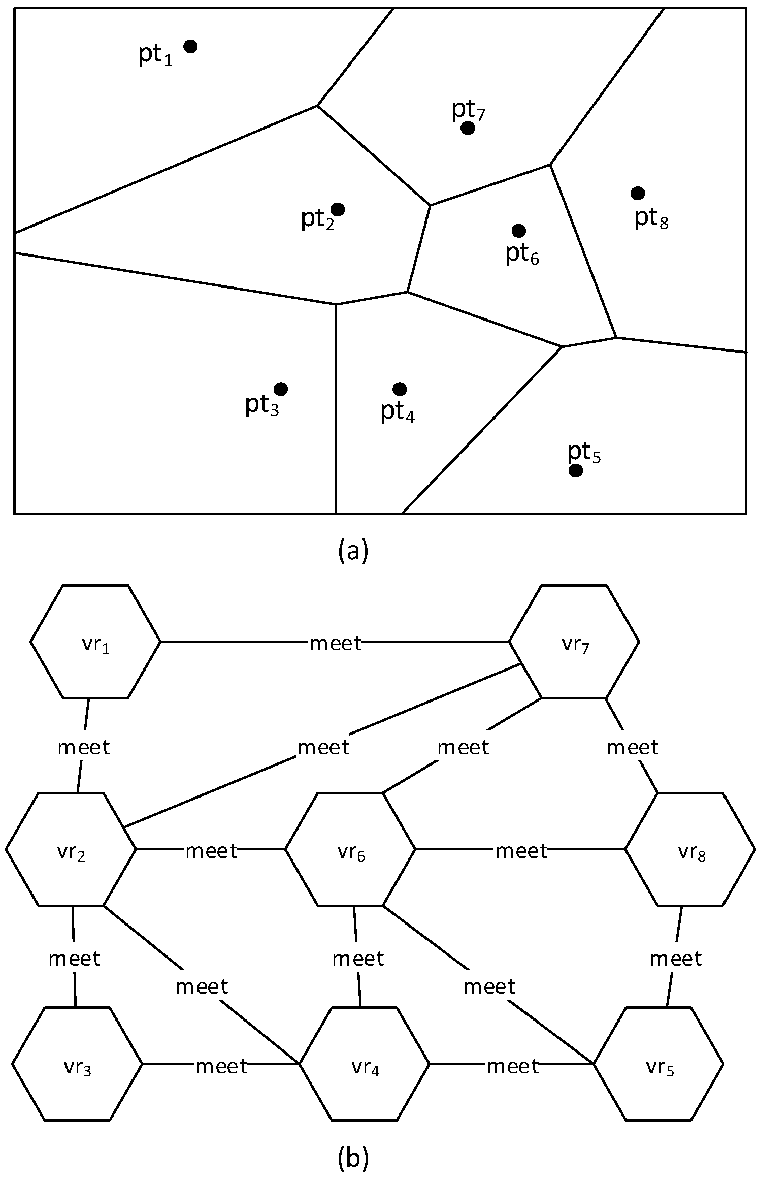
3.1. Geographical Graph
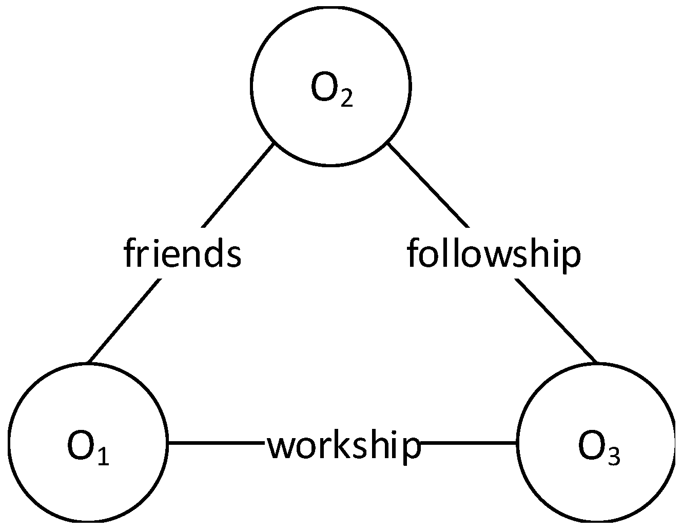
3.2. Social Graph
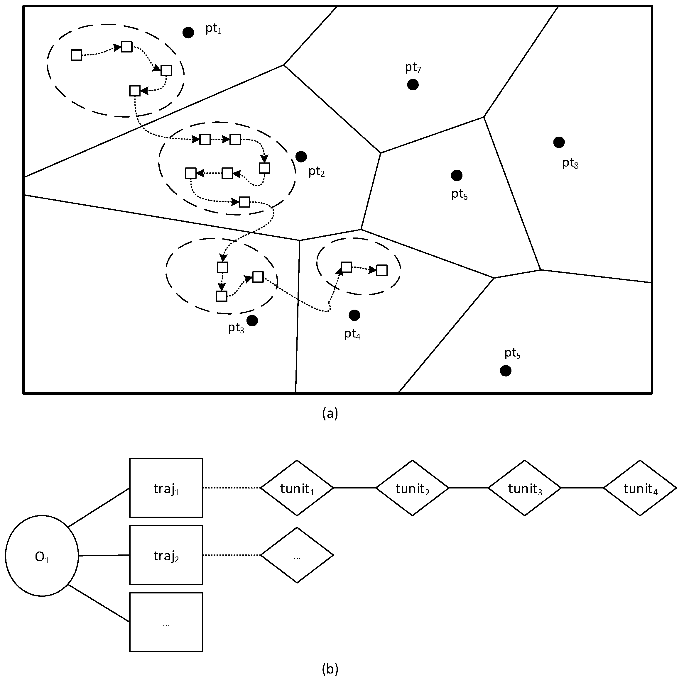
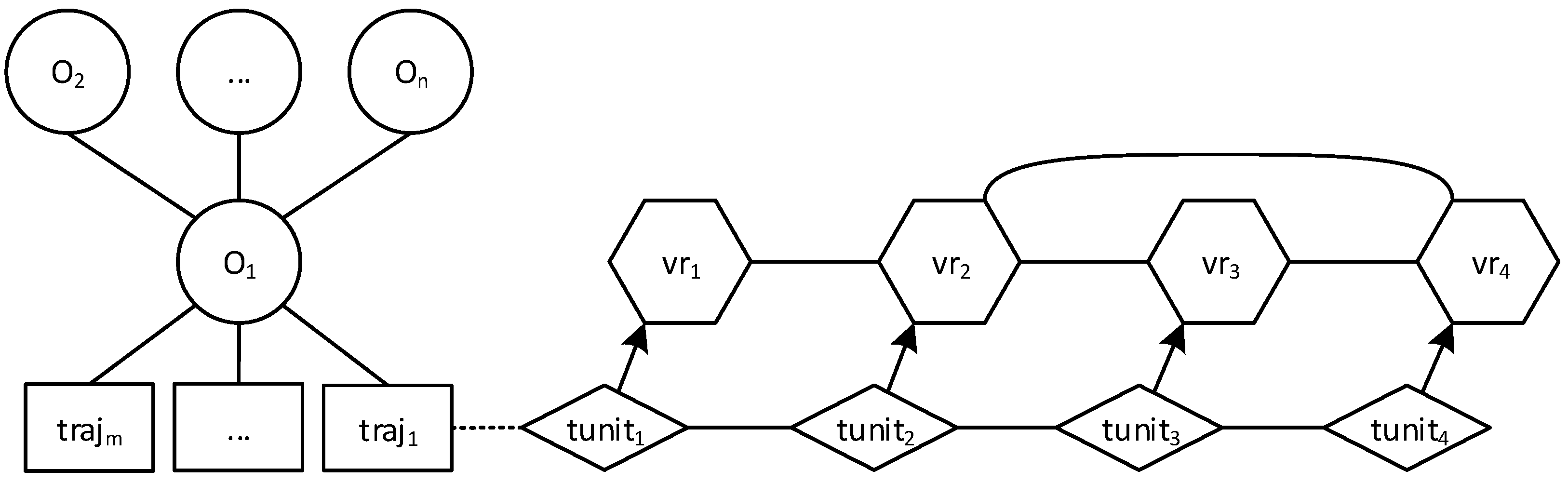
3.3. Movement Graph
4. Data Types and Operators
4.1. Data Types
4.2. Operators
5. Implementation
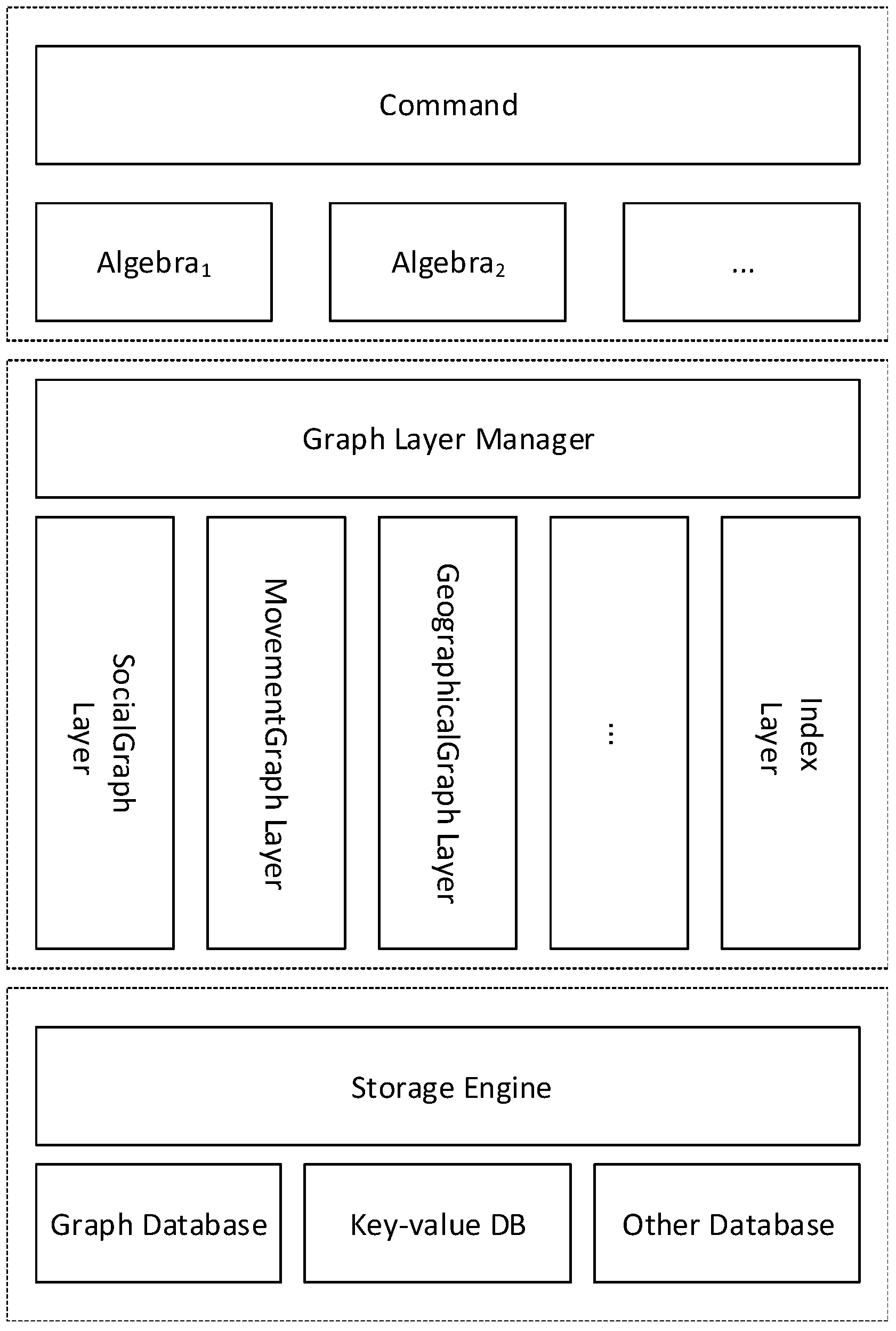
5.1. System Architecture
5.2. Prototype Implementation
| Query 1: What is Jack’s email address? |
| nodevalues( |
| select(Gs, name =′ jack′), email) |
| Query 2: Find all of Jack’s friends. |
| nodevalues( |
| getnodes( |
| select(Gs, name =′ jack′), friendship), name) |
| Query 3: Find the trajectory distance between Jack and John. |
| distance( |
| getrajectory( |
| select(Gs, name =′ jack′), 2015 − 07 − 22) |
| getrajectory( |
| select(Gs, name =′ John′), 2015 − 07 − 22))) |
| Query 4: Where was Jack at 10 a.m.? |
| atinstants( |
| getrajectory( |
| select(Gs, name =′ jack′), 2015 − 07 − 22), 10 : 00) |
| Query 5: Find Jack’s trajectories between 10 a.m. and 12 a.m. |
| atperiods( |
| getrajectory( |
| select(Gs, name =′ jack′), 2015 − 07 − 22), 10 : 00, 12 : 00)) |
| Query 6: When did Jack pass Joy City shopping mall?. |
| exinstants( |
| getrajectory( |
| select(Gs, name =′ jack′), 2015 − 07 − 22), Joycity) |
6. Experiments
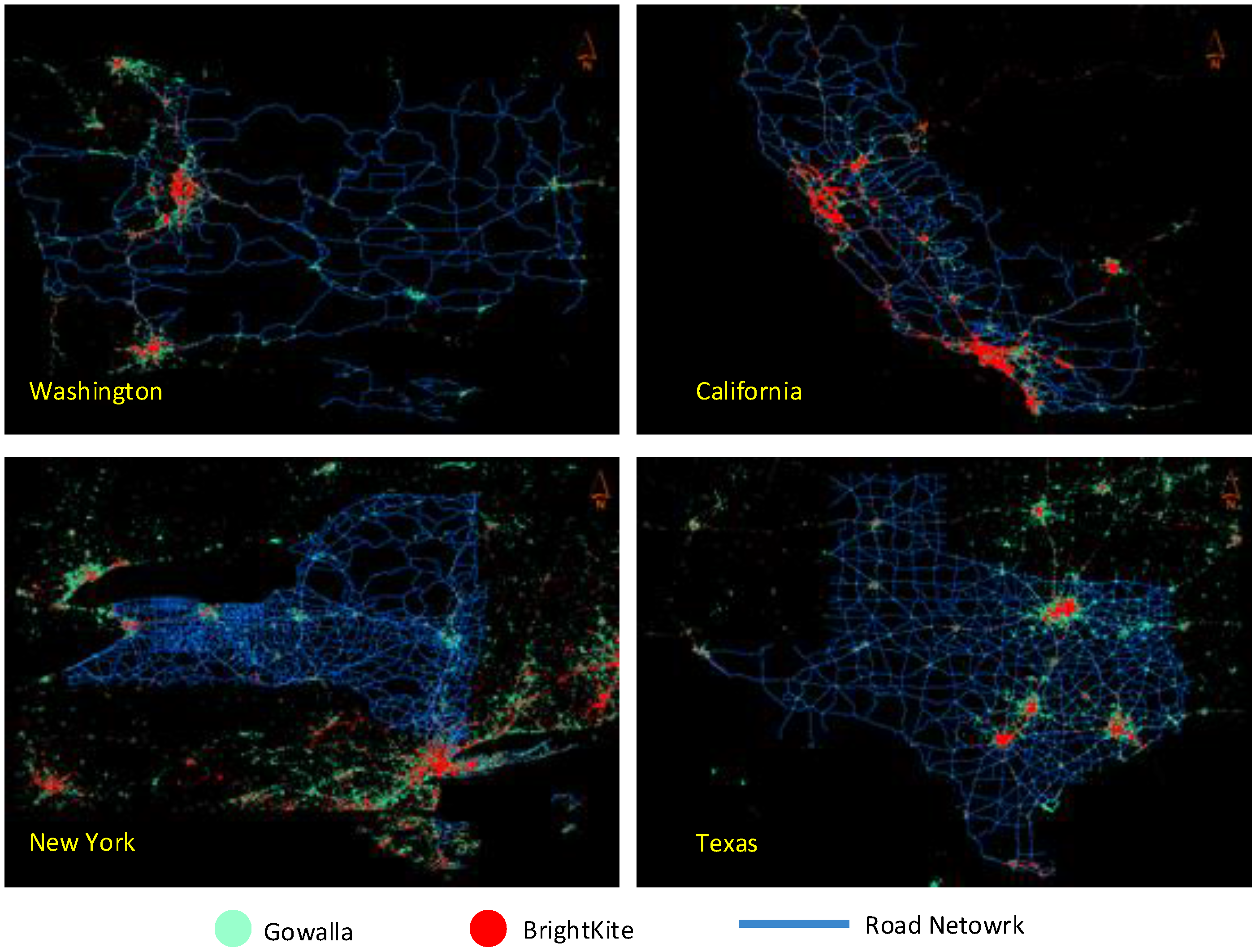
6.1. Experimental Setting
- CREATE TABLE objects (moID int, email char, oname char);
- CREATE TABLE socialrelation (fromMOID int, relation char, toMOID int);
- CREATE TABLE trajectory (trajID int, traj geometry, oname char);
- CREATE INDEX idxmo ON objects (moID);
- CREATE INDEX idxids ON socialrelation (fromMOID, toMOID);
- CREATE INDEX idxtraj ON trajectory USING RTREE (traj).
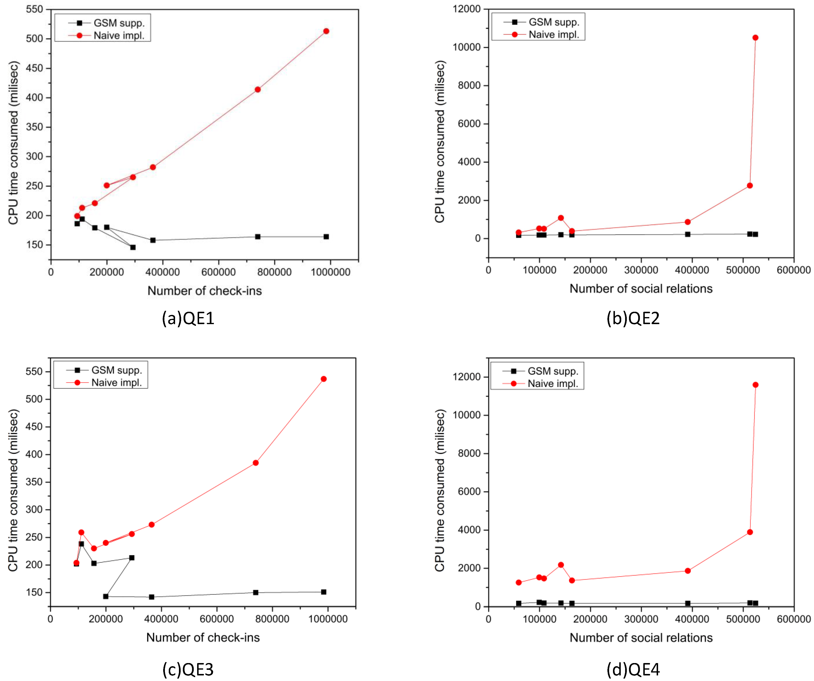
6.2. Experimental Results
7. Discussion
8. Conclusions
Acknowledgments
Author Contributions
Conflicts of Interest
Abbreviations
| GSM | Geo-Social-Moving |
| DC | Washington |
| CA | California |
| NY | New York |
| TX | Texas |
| QE1 | Query expression 1 |
| QE2 | Query expression 2 |
| QE3 | Query expression 3 |
| QE4 | Query expression 4 |
References
- Guting, R.H.; Lu, J. Parallel SECONDO: Scalable query processing in the cloud for non-standard applications. SIGSPATIAL Spec. 2015, 6, 3–10. [Google Scholar] [CrossRef]
- Guting, R.H.; Ding, Z. Modeling and querying moving objects in networks. VLDB J. 2006, 15, 165–190. [Google Scholar] [CrossRef]
- Hajari, H.; Hakimpour, F. A spatial data model for moving object databases. Int. J. Database Manag. Syst. 2014, 6, 1–20. [Google Scholar] [CrossRef]
- Meng, X.; Ding, Z.; Xu, J. Moving Objects Modeling, Moving Objects Management; Springer: Berlin, Germany; Heidelberg, Germany, 2014. [Google Scholar]
- Chen, B.Y.; Yuan, H.; Li, Q.; Shaw, S.-L.; Lam, W.H.; Chen, X. Spatiotemporal data model for network time geographic analysis in the era of big data. Int. J. Geogr. Inf. Sci. 2015, 30, 1–31. [Google Scholar] [CrossRef]
- Wolfson, O.; Xu, B.; Chamberlain, S.; Jiang, L. Moving Objects Databases: Issues and Solutions; IEEE: Chicago, IL, USA, 1998. [Google Scholar]
- Ding, Z. UTR-tree: An index structure for the full uncertain trajectories of network-constrained moving objects. In Proceedings of the Ninth International Conference on Mobile Data Management (MDM 2008), Beijing, China, 27–30 April 2008; pp. 33–40.
- Jung, H.; Kim, Y.S.; Chung, Y.D. QR-tree: An efficient and scalable method for evaluation of continuous range queries. Inf. Sci. 2014, 274, 156–176. [Google Scholar] [CrossRef]
- Pfoser, D.; Jensen, C.S.; Theodoridis, Y. Novel Approaches to the Indexing of Moving Object Trajectories; Morgan Kaufmann Publishers Inc.: San Francisco, CA, USA, 2000. [Google Scholar]
- Xu, J.; Guting, R.H.; Zheng, Y. The TM-RTree: An index on generic moving objects for range queries. GeoInformatica 2015, 19, 487–524. [Google Scholar] [CrossRef]
- Sacharidis, D.; Skoutas, D.; Skoumas, G. Continuous monitoring of nearest trajectories. In Proceedings of the 22nd ACM SIGSPATIAL International Conference on Advances in Geographic Information Systems, Dallas, TX, USA, 4–7 November 2014; pp. 361–370.
- Shao, Z.; Taniar, D. Enhanced range search with objects outside query range. World Wide Web 2015, 18, 1–23. [Google Scholar] [CrossRef]
- Silvestri, C.; Lettich, F.; Orlando, S.; Jensen, C.S. GPU-based computing of repeated range queries over moving objects. In Proceedings of the 2014 22nd Euromicro International Conference on Parallel, Distributed and Network-Based Processing (PDP), Torino, Italy, 12–14 February 2014; pp. 640–647.
- Zhang, R.; Qi, J.; Lin, D.; Wang, W.; Wong, R.C.-W. A highly optimized algorithm for continuous intersection join queries over moving objects. VLDB J. 2012, 21, 561–586. [Google Scholar] [CrossRef]
- Trajcevski, G.; Tamassia, R.; Cruz, I.F.; Scheuermann, P.; Hartglass, D.; Zamierowski, C. Ranking continuous nearest neighbors for uncertain trajectories. VLDB J. 2011, 20, 767–791. [Google Scholar] [CrossRef]
- Long, J.A.; Nelson, T.A. A review of quantitative methods for movement data. Int. J. Geogr. Inf. Sci. 2013, 27, 292–318. [Google Scholar] [CrossRef]
- Pelekis, N.; Theodoridis, Y.; Janssens, D. On the management and analysis of our lifesteps. ACM SIGKDD Explor. Newsl. 2014, 15, 23–32. [Google Scholar] [CrossRef]
- Zheng, Y. Trajectory data mining: an overview. ACM Trans. Intell. Syst. Technol. (TIST) 2015, 6, 29–41. [Google Scholar] [CrossRef]
- Cho, E.; Myers, S.A.; Leskovec, J. Friendship and mobility: User movement in location-based social networks. In Proceedings of the 17th ACM SIGKDD International Conference on Knowledge Discovery and Data Mining, San Diego, CA, USA, 21–24 August 2011; pp. 1082–1090.
- Scellato, S.; Noulas, A.; Mascolo, C. Exploiting place features in link prediction on location-based social networks. In Proceedings of the 17th ACM SIGKDD International Conference on Knowledge Discovery and Data Mining, San Diego, CA, USA, 21–24 August 2011; pp. 1046–1054.
- Crandall, D.J.; Backstrom, L.; Cosley, D.; Suri, S.; Huttenlocher, D.; Kleinberg, J. Inferring social ties from geographic coincidences. Proc. Natl. Acad. Sci. 2010, 107, 22436–22441. [Google Scholar] [CrossRef] [PubMed]
- Tang, W.; Zhuang, H.; Tang, J. Learning to infer social ties in large networks. Mach. Learn. Knowl. Discov. Databases 2011, 6913, 381–397. [Google Scholar]
- Fowler, G.A. Facebook: One billion and counting. Wall Street J. 2012, 4, 1–10. [Google Scholar]
- Chorley, M.J.; Whitaker, R.M.; Allen, S.M. Personality and location-based social networks. Comput. Human Behav. 2015, 46, 45–56. [Google Scholar] [CrossRef]
- Ahuja, R.; Armenatzoglou, N.; Papadias, D.; Fakas, G.J. Geo-Social Keyword Search. Adv. Spat. Tempor. Databases 2015, 9329, 431–450. [Google Scholar]
- Shi, J.; Mamoulis, N.; Wu, D.; Cheung, D.W. Density-based place clustering in geo-social networks. In Proceedings of the 2014 ACM SIGMOD International Conference on Management of Data, Snowbird, UT, USA, 22–27 June 2014; pp. 99–110.
- Zhuang, H.; Tang, J.; Tang, W.; Lou, T.; Chin, A.; Wang, X. Actively learning to infer social ties. Data Min. Knowl. Discov. 2012, 25, 1–28. [Google Scholar] [CrossRef]
- Angles, R.; Gutierrez, C. Survey of graph database models. ACM Computing Surv. (CSUR) 2008, 40, 1–10. [Google Scholar] [CrossRef]
- Holzschuher, F.; Peinl, R. Performance of graph query languages: Comparison of cypher, gremlin and native access in Neo4j. In Proceedings of the Joint EDBT/ICDT 2013 Workshops, Genoa, Italy, 18–22 March 2013; pp. 195–204.
- Schneider, M. Moving Objects in Databases and GIS: State-of-the-art and Open Problems, Research Trends in Geographic Information Science; Springer: Berlin, Germany, 2009. [Google Scholar]
- Sistla, A.P.; Wolfson, O.; Chamberlain, S.; Dao, S. Modeling and querying moving objects. In Proceedings of the International Conference on Data Engineering (ICDE), Birmingham, UK, 7–11 April 1997; pp. 422–432.
- Wolfson, O.; Chamberlain, S.; Dao, S.; Jiang, L.; Mendez, G. Cost and Imprecision in Modeling the Position of Moving Objects; IEEE: Chicago, IL, USA, 1998. [Google Scholar]
- Wolfson, O.; Chamberlain, S.; Kalpakis, K.; Yesha, Y. Modeling moving objects for location based services. Dev. Infrastruct. Mob. Wirel. Syst. 2002, 2538, 46–58. [Google Scholar]
- Forlizzi, L.; Guting, R.H.; Nardelli, E.; Schneider, M. A data model and data structures for moving objects databases. ACM SIGMOD 2000, 29, 319–330. [Google Scholar] [CrossRef]
- Guting, R.H.; Böhlen, M.H.; Erwig, M.; Jensen, C.S.; Lorentzos, N.A.; Schneider, M.; Vazirgiannis, M. A foundation for representing and querying moving objects. ACM Trans. Database Syst. (TODS) 2000, 25, 1–42. [Google Scholar] [CrossRef]
- Meng, X.; Ding, Z. DSTTMOD: A future trajectory based moving objects database. Database Expert Syst. Appl. 2003, 2736, 444–453. [Google Scholar]
- Parent, C.; Spaccapietra, S.; RENSO, C.; Andrienko, G.; Bogorny, V.; Damiani, M.L.; Macedo, J.; Pelekis, N.; Theoderidis, Y.; Yan, Z. Semantic trajectories modeling and analysis. ACM Computing Surv. 2013, 45, 39–76. [Google Scholar] [CrossRef]
- Yan, Z.; Chakraborty, D.; Parent, C.; Spaccapietra, S.; Aberer, K. Semantic trajectories: Mobility data computation and annotation. ACM Trans. Intell. Syst. Technol. (TIST) 2013, 4, 49. [Google Scholar] [CrossRef]
- Sandu Popa, I. Modeling, Querying and Indexing Moving Objects with Sensors on Road Networks; University of Versailles-Saint-Quentin: Paris, France, 2010. [Google Scholar]
- Jensen, C.S.; Lu, H.; Yang, B. Indoor—A new data management frontier. IEEE Data Eng. Bull. 2010, 33, 12–17. [Google Scholar]
- Jin, P.; Zhang, L.; Zhao, L.; Wang, H.; Yue, L. Electronic RFID-based indoor moving objects: Modeling and applications. Adv. Mech. Electron. Eng. 2012, 177, 455–461. [Google Scholar]
- Kim, Y.; Kang, H.; Lee, J. Development of indoor spatial data model using CityGML ADE. J. Korea Spat. Inf. Soc. 2013, 21, 11–21. [Google Scholar] [CrossRef]
- Brinkhoff, T. A framework for generating network-based moving objects. GeoInformatica 2002, 6, 153–180. [Google Scholar] [CrossRef]
- Saglio, J.-M.; Moreira, J. Oporto: A realistic scenario generator for moving objects. GeoInformatica 2001, 5, 71–93. [Google Scholar] [CrossRef]
- Theodoridis, Y.; Silva, J.R.; Nascimento, M.A. On the generation of spatiotemporal datasets, Advances in Spatial Databases. Springer 1999, 1651, 147–164. [Google Scholar]
- Xu, J.; Guting, R.H. GMOBench: A benchmark for generic moving objects. In Proceedings of the 20th International Conference on Advances in Geographic Information Systems, Redondo Beach, CA, USA, 7–9 November 2012; pp. 410–413.
- Huang, S.-C.; Chen, B.-H. Highly accurate moving object detection in variable bit rate video-based traffic monitoring systems. IEEE Trans. Neural Netw. Learning Syst. 2013, 24, 1920–1931. [Google Scholar] [CrossRef] [PubMed]
- Huang, S.-C.; Do, B.-H. Radial basis function based neural network for motion detection in dynamic scenes. IEEE Trans. Cyber. 2014, 44, 114–125. [Google Scholar] [CrossRef] [PubMed]
- Cheng, F.-C.; Chen, B.-H.; Huang, S.-C. A background model re-initialization method based on sudden luminance change detection. Eng. Appl. Artif. Intell. 2015, 38, 138–146. [Google Scholar] [CrossRef]
- Cheng, F.-C.; Chen, B.-H.; Huang, S.-C. A hybrid background subtraction method with background and foreground candidates detection. ACM Trans. Intell. Syst. Technol. (TIST) 2015, 7, 21–31. [Google Scholar] [CrossRef]
- Chen, B.-H.; Huang, S.-C. Probabilistic neural networks based moving vehicles extraction algorithm for intelligent traffic surveillance systems. Inf. Sci. 2015, 299, 283–295. [Google Scholar] [CrossRef]
- Bogorny, V.; Renso, C.; Aquino, A.R.; Lucca Siqueira, F.; Alvares, L.O. CONSTAnT-a conceptual data model for semantic trajectories of moving objects. Trans. GIS 2014, 18, 66–88. [Google Scholar] [CrossRef]
- Spaccapietra, S.; Parent, C.; Damiani, M.L.; de Macedo, J.A.; Porto, F.; Vangenot, C. A conceptual view on trajectories. Data Knowl. Eng. 2008, 65, 126–146. [Google Scholar] [CrossRef] [Green Version]
- Zheni, D.; Frihida, A.; Ghezala, H.; Claramunt, C. A semantic approach for the modeling of trajectories in space and time. Adv. Concept. Model. Chall. Perspect. 2009, 5833, 347–356. [Google Scholar]
- Mokbel, M.F.; Sarwat, M. Mobility and social networking: A data management perspective. Proc. VLDB Endow. 2013, 6, 1196–1197. [Google Scholar] [CrossRef]
- Zheni, D.; Frihida, A.; Claramunt, C.; Ghezala, H.B. A semantic-based data model for the manipulation of trajectories: Application to urban transportation. Web Wirel. Geogr. Inf. Syst. 2015, 9080, 124–142. [Google Scholar]
- Yan, Z.; Chakraborty, D.; Parent, C.; Spaccapietra, S.; Aberer, K. SeMiTri: A framework for semantic annotation of heterogeneous trajectories. In Proceedings of the 14th International Conference on Extending Database Technology, Uppsala, Sweden, 21–24 March 2011; pp. 259–270.
- Bogorny, V.; Avancini, H.; de Paula, B.C.; Kuplich, C.R.; Alvares, L.O. Weka-STPM: A software architecture and prototype for semantic trajectory data mining and visualization. Trans. GIS 2011, 15, 227–248. [Google Scholar] [CrossRef]
- Bogorny, V.; Heuser, C.; Alvares, L. A conceptual data model for trajectory data mining. Geogr. Inf. Sci. 2010, 6292, 1–15. [Google Scholar]
- Damiani, M.L.; Valdes, F.; Issa, H. Moving objects beyond raw and semantic trajectories. In Proceedings Of the 3rd International Workshop on Information Management for Mobile Applications, Riva del Garda, Italy, 26 August 2013; Volume 4, pp. 1–10.
- Hu, Y.; Janowicz, K.; Carral, D.; Scheider, S.; Kuhn, W.; Berg-Cross, G.; Hitzler, P.; Dean, M.; Kolas, D. A geo-ontology design pattern for semantic trajectories. Spat. Inf. Theory 2013, 8116, 438–456. [Google Scholar]
- Paiva Nogueira, T.; Bezerra Braga, R.; Martin, H. An ontology-based approach to represent trajectory characteristics. In Proceedings of the 2014 Fifth International Conference on Computing for Geospatial Research and Application, Washington, DC, USA, 4–6 August 2014; pp. 102–107.
- Yan, Z.; Macedo, J.; Parent, C.; Spaccapietra, S. Trajectory ontologies and queries. Trans. GIS 2008, 12, 75–91. [Google Scholar] [CrossRef]
- Boulmakoul, A.; Karim, L.; Lbath, A. Moving object trajectories meta-model and spatio-temporal queries. Int. J. Database Manag. Syst. 2012, 4, 35–54. [Google Scholar] [CrossRef]
- Kolahdouzan, M.; Shahabi, C. Voronoi-based k nearest neighbor search for spatial network databases. In Proceedings of the Thirtieth International Conference on Very Large Data Bases-Volume 30, Toronto, Canada, 29 August–3 September 2004; pp. 840–851.
- Egenhofer, M.J.; Franzosa, R.D. Point-set topological spatial relations. Int. J. Geogr. Inf. Syst. 1991, 5, 161–174. [Google Scholar] [CrossRef]
- Egenhofer, M.J.; Herring, J. A mathematical framework for the definition of topological relationships. In Proceedings of the Fourth International Symposium on Spatial Data Handling, Zurich, Switzerland, 23–27 July 1990; pp. 803–813.
- Düntgen, C.; Behr, T.; Guting, R.H. BerlinMOD: A benchmark for moving object databases. VLDB J. 2009, 18, 1335–1368. [Google Scholar] [CrossRef]
- Guting, R.H.; Behr, T.; Düntgen, C. Secondo: A platform for moving objects database research and for publishing and integrating research implementations. IEEE Data Eng. Bull. 2010, 33, 56–63. [Google Scholar]
- Guting, R.H.; Almeida, V.; Ansorge, D.; Behr, T.; Ding, Z.; Höse, T.; Hoffmann, F.; Spiekermann, M. SECONDO: An extensible DBMS platform for research prototyping and teaching. In Proceedings of the 21st International Conference on Data Engineering (ICDE’05), Tokyo, Japan, 5–8 April 2005; pp. 1115–1116.


| Operations | Signature |
|---|---|
| Select | × string → VR |
| × string → MO | |
| × string → | |
| Nodevalues | VR × string → string |
| MO × string → string | |
| × string → string | |
| Getnodes | MO × string → MO |
| MO × string → VR | |
| MO × string → | |
| Getrajectory | MO × instant → trajectory |
| Atinstants | trajectory × instant → gpos |
| Atperiods | trajectory × period → |
| Exinstants | trajectory × point → instant |
| Distance | trajectory × trajectory → real |
| Voronoi Regions | Moving Objects | Social Relationships | Check-in Records | |
|---|---|---|---|---|
| DC-GO | 8655 | 5058 | 163,622 | 199,469 |
| DC-BK | 18,655 | 797 | 59,194 | 93,816 |
| CA-GO | 57,251 | 16,684 | 513,406 | 739,687 |
| CA-BK | 57,251 | 2450 | 142,136 | 293,542 |
| NY-GO | 21,657 | 12,388 | 391,144 | 364,940 |
| NY-BK | 21,657 | 1789 | 108,678 | 157,020 |
| TX-GO | 40,178 | 17,996 | 524,352 | 984,493 |
| TX-BK | 40,178 | 1328 | 99,528 | 111,247 |
| Query Expression | |
|---|---|
| QE1 | atinstants( |
| getrajectory( | |
| select(Gs, name =′ Jack′), 2015 − 07 − 22), 10 : 00) | |
| QE2 | atinstants( |
| getrajectory( | |
| getnodes( | |
| select(Gs, name =′ Jack′), friendship), 2015 − 07 − 22), 10 : 00) | |
| QE3 | atperiods( |
| getrajectory( | |
| select(Gs, name =′ Jack′), 2015 − 07 − 22), (10 : 00, 12 : 00)) | |
| QE4 | exinstants( |
| getrajectory( | |
| getnodes( | |
| select(Gs, name =′ Jack′), friendship), 2015 − 07 − 22)), Joycity) |
| QE1 | QE2 | QE3 | QE4 | |||||
|---|---|---|---|---|---|---|---|---|
| GSM Supp. | Naive Impl. | GSM Supp. | Naive Impl. | GSM Supp. | Naive Impl. | GSM Supp. | Naive Impl. | |
| CA-BK | 146 | 265 | 200 | 1082 | 213 | 256 | 185 | 2182 |
| CA-GO | 164 | 414 | 236 | 2771 | 150 | 385 | 189 | 3894 |
| NY-BK | 179 | 221 | 185 | 516 | 203 | 230 | 182 | 1474 |
| NY-GO | 158 | 282 | 219 | 865 | 142 | 273 | 171 | 1869 |
| TX-BK | 194 | 213 | 185 | 524 | 238 | 259 | 219 | 1528 |
| TX-GO | 164 | 513 | 220 | 10510 | 151 | 537 | 177 | 11593 |
| DC-BK | 186 | 199 | 173 | 318 | 202 | 204 | 167 | 1260 |
| DC-GO | 180 | 251 | 195 | 390 | 143 | 240 | 167 | 1367 |
© 2016 by the authors; licensee MDPI, Basel, Switzerland. This article is an open access article distributed under the terms and conditions of the Creative Commons Attribution (CC-BY) license (http://creativecommons.org/licenses/by/4.0/).
Share and Cite
Zhang, H.; Lu, F.; Xu, J. Modeling and Querying Moving Objects with Social Relationships. ISPRS Int. J. Geo-Inf. 2016, 5, 121. https://0-doi-org.brum.beds.ac.uk/10.3390/ijgi5070121
Zhang H, Lu F, Xu J. Modeling and Querying Moving Objects with Social Relationships. ISPRS International Journal of Geo-Information. 2016; 5(7):121. https://0-doi-org.brum.beds.ac.uk/10.3390/ijgi5070121
Chicago/Turabian StyleZhang, Hengcai, Feng Lu, and Jianqiu Xu. 2016. "Modeling and Querying Moving Objects with Social Relationships" ISPRS International Journal of Geo-Information 5, no. 7: 121. https://0-doi-org.brum.beds.ac.uk/10.3390/ijgi5070121