
A Country Profile of the Czech Republic Based on an LADM for the Development of a 3D Cadastre


1
Department of Geomatics, Faculty of Applied Sciences, University of West Bohemia, Pilsen 30614, Czech Republic
2
Czech Office for Surveying, Mapping and Cadastre, Prague 18211, Czech Republic
*
Author to whom correspondence should be addressed.
ISPRS Int. J. Geo-Inf. 2017, 6(5), 143; https://0-doi-org.brum.beds.ac.uk/10.3390/ijgi6050143
Submission received: 24 February 2017
/
Revised: 27 April 2017
/
Accepted: 28 April 2017
/
Published: 3 May 2017
(This article belongs to the Special Issue Research and Development Progress in 3D Cadastral Systems)
Abstract
:The paper presents a country profile for the cadastre of the Czech Republic based on the ISO 19152:2012 Land Administration Domain Model (LADM). The proposed profile consists of both legal and spatial components and represents an important driving force with which to develop a 3D cadastre for the Czech Republic, which can guide the Strategy for the Development of the Infrastructure for Spatial Information in the Czech Republic to 2020. This government initiative emphasizes the creation of the National Set of Spatial Objects, which is defined as the source of guaranteed and reference 3D geographic data at the highest possible level of detail covering the entire territory of the Czech Republic. This can also be a potential source of data for the 3D cadastre. The abstract test suite stated in ISO 19152:2012—Annex A (Abstract Test Suite) and the LADM conformance requirements were applied in order to explore the conformity of the Czech country profile with this international standard. To test their conformity, a mapping of elements between the LADM and the tested country profile was conducted. The profile is conformant with the LADM at Level 2 (medium level) and can be further modified, especially when legislation is updated with respect to 3D real estate in the future.
1. Introduction
The cadastre of real estate (KN) is one of the largest data information systems in the state administration of the Czech Republic. It is composed of data regarding real estate located within the Czech Republic, including a detailed inventory with descriptions of each estate’s geometric specifications and location, as well as records of property, other material rights and additional legally-stipulated rights to real estate. The cadastre of real estate also contains a great deal of important data concerning parcels, as well as selected buildings and their owners. The KN, which is the primary information system concerning the territory of the Czech Republic, is administered mainly through computational means, wherein the cadastral unit is the fundamental territorial unit. The cadastre’s documentation primarily comprises files of geodetic information encompassing the cadastral map (including its digital representation in given cadastral units), as well as files containing descriptive information regarding cadastral units, parcels, buildings, flats and non-residential premises, owners and other justified persons and legal relations and rights, in addition to other legal facts.
Several objectives have been proposed that drive the creation of a country profile based on the ISO 19152 Land Administration Domain Model (LADM) [1]. In October 2014, the Czech government approved the conception of The Strategy for the Development of the Infrastructure for Spatial Information in the Czech Republic to 2020 (GeoInfoStrategy), which serves as a basis for the National Spatial Data Infrastructure (NSDI). The set of measures to be used to develop the regulatory framework in the field of spatial information was then defined in the GeoInfoStrategy Action Plan [2]. This Action Plan considers the adoption of the ISO 19152 standard within various government initiatives. In particular, using ISO 19152 is recommended for the further development of the register of territorial identification, addresses and real estate and for the feasibility study of the register of passive infrastructure. This indicates that, during the implementation of the GeoInfoStrategy Action Plan, there will be a demand for thorough knowledge and understanding of the LADM concept. Both of the aforementioned registers could be considered as the cornerstone of the Czech National Spatial Data Infrastructure [3].
There is a strong emphasis on the creation of a National Set of Spatial Objects (NSSO) within the GeoInfoStrategy. The NSSO (which includes 3D buildings) is defined as the source of guaranteed, as well as reference (where possible) 3D geographic data at the highest possible level of detail for selected objects in the real world and covers the entire territory of the Czech Republic. It is not explicitly stated within the GeoInfoStrategy that the parcels should be registered in 3D. However, the proposed model based on an LADM could be potentially extended to support the registration of 3D parcels (spatial units) in the future, and it could also serve as the basis for an extension of the current data model of the cadastre in a standardized way.
Furthermore, the Czech version of ISO 19152 has existed since October 2013. The National Mirror Committee 122 of Geographic Information/Geomatics was responsible for the translation. Both of the authors of this paper are members of this committee. During the translation work, the members of the committee discussed the use of ISO 19152 in the Czech Republic. The conclusions reached incorporated a first step wherein a country profile of the Czech Republic based on an LADM should be constructed, after which the country profile should be tested against the LADM concept.
Feedback from professionals (i.e., surveyors) who utilize the cadastre on a day-to-day basis represented an important incentive in this process. This positive feedback was often obtained during presentations regarding a 3D cadastre that were delivered at national events and conferences. For example, the Czech Union of Surveyors and Cartographers (a member of International Federation of Surveyors (FIG)) declared an interest in a 3D cadastre and thereafter demonstrated the need for a 3D cadastre on the grounds of several applications (e.g., the registration of complex buildings, underground constructions, etc.).
Ultimately, the new Civil Code (Act No. 89/2012 Coll.) was enacted within the Czech Republic in 2014. This Act addresses several aspects of the 3D cadastre. The new Civil Code explicitly considers the 3D space both above and below the parcel as a part of the land. This includes the space above and below the surface, buildings established on the land and other facilities (excluding temporary buildings), including what is embedded in the land or fixed in the walls. Furthermore, according to the new Civil Code, the land incorporates real estate and underground construction characterized by separate special-purpose uses, as well as their corresponding property rights. In practice, many underground constructions are not registered in the cadastre. Currently, underground constructions are only registered in the case when some part(s) of the construction is located above ground. Figure 1 illustrates an example of such an underground construction, and the manner in which this construction is displayed on a map is illustrated in Figure 2. Furthermore, even if an underground construction is not considered real estate, it is still a part of the land if it affects (i.e., is located beneath) the parcel. For example, if a building with an underground cellar is standing on Parcel A and the underground cellar is partially located beneath the neighboring Parcel B, then the entire underground cellar is a component of the building standing atop Parcel A (and, according to the superficies solo cedit principle, this building belongs to Parcel A). Consequently, a landowner must also accept the use of space over or under the land if the parcel conforms to these laws and if the owner does not have sufficient cause to oppose it.
The new Civil Code encompasses numerous provisions from other acts that were recently repealed, e.g., the Flat Ownership Act, the Act on Association of Persons, etc. It re-introduces the former Czech legal terminology, which was gradually abandoned by the Civil Codes of 1950 and 1964. The Property Law component regulates the tenure, possession, ownership and co-ownership, encumbrance, lien and heirship of real estate property. Concordant with the adoption of the New Civil Code, a new Cadastral Act (Law Number 256/2013 Coll., the “New Cadastral Act”) was enacted as a basic legal cornerstone of the cadastre of real estate of the Czech Republic. The Cadastral Law defines a parcel as a piece of land that is projected onto the horizontal plane (a 2D cadastral map). The Law does not explicitly state that the 3D space above and below the parcel is a component of the parcel (i.e., it does not constitute a 3D parcel). However, as has been previously discussed [5], though parcels are represented in 2D, someone with a right to a parcel has always been entitled to the 3D space. That is, the right of ownership of a parcel relates to the 3D space, is not solely limited to the flat parcel defined in 2D absent height or depth and can therefore be used by the owner.
Recently, several country profiles based on an LADM have been proposed [6,7,8,9]. This paper presents the first version of a Czech country profile [10]. Considering the proposal for an LADM-based country profile, the ambitions of this study are (1) to ensure that the LADM-based country profile reflects the current cadastral registration and the corresponding legal requirements with a possible extension into 3D and (2) to determine the compatibility between the proposed Czech country profile and the LADM. This paper describes a feasible “show case,” which could be used as a type of guideline for others conducting or planning a similar application.
2. GeoInfoStrategy and Selected Use Cases Dealing with a 3D Cadastre
The vision of the GeoInfoStrategy is that, in 2020, the Czech Republic is a society educated in the effective use of spatial information. To fulfil this vision, it is necessary to ensure that spatial information and services will be utilized in every aspect of public life. The GeoInfoStrategy represents a conceptual plan that is closely related to other strategic documents of public administration and eGovernment and defines the principles and strategic ambitions for the effective use of spatial information in public administration. The approved GeoInfoStrategy contains a description of several case studies of applications that may employ a 3D cadastre, such as the administration of networks of technical infrastructure or the creation of 3D building models for noise mapping [11].
Considering networks of technical infrastructure, the Czech Republic should establish a register of passive infrastructure that would be intended to contain information regarding the 3D location (using absolute heights) of networks, as well as network owners and administrators. In the approved GeoInfoStrategy Action Plan, the use of ISO 19152 (LADM) is recommended as an input document in order to create a feasibility study of this register. An LADM distinguishes between the physical representation of a spatial object (outside the scope of the LADM) and a legal registration of the space (within the scope of the LADM) required by the physical objects. Such legal spaces could then be registered within the cadastre. Currently, the (legal) information concerning the networks of technical infrastructure is not registered in the cadastre. However, numerous issues could be addressed if this information existed within the cadastre, such as the routes of cable lines beneath certain parcels of real estate, and so on. This is pertinent because many parcel owners are unaware whether cables or pipelines are located beneath their parcel.
This legal registration should then provide a clear overview of the property rights involved, including the rights regarding the network on the one hand (e.g., ownership) and the rights regarding the land established for the benefit of a network on the other hand (e.g., easement). An approach to register the legal space of utility networks could ensure that the geometry of physical utility networks is located within the database of utility companies (or in the established register of passive infrastructure), which can then serve as a dynamic reference within the cadastre. The legal objects for utility networks can then be generated in a controlled (regulated) manner from the 3D descriptions of the physical objects. Because of the permanent nature of the connection, the legal registration can be better maintained. This fits well within the LADM [12]. ISO 19152 offers a subclass LA_LegalSpaceUtilityNetwork (of the class LA_SpatialUnit) in order to support the registration of information (legal spaces) concerning the utilities together with cadastral data. A previous study [12] examined the characteristics of utility networks as 4D (3D space + time) objects and showed that an approach utilizing the 3D space, as well as the separate temporal attributes, is a very promising solution with which to maintain and record temporal changes in utility networks.
Another case study within the GeoInfoStrategy considers the creation of models of 3D buildings primarily for the purpose of strategic noise mapping, the production of which should be accomplished using preexisting spatial data sources (e.g., 2D digital cadastral maps and laser scans). The laser scans could also be used for updating existing 3D models. In this regard, modifications using point clouds can only be detected for visible components (i.e., above ground) of objects or boundaries [13]. The requested level of detail (LOD) for this case study of 3D buildings for strategic noise mapping is LOD1 according to the specifications of CityGML [14]. Furthermore, using the aforementioned spatial data sources, the buildings at LOD2 could also be created. Such models can then serve 3D cadastral purposes [15,16]. If the buildings are originally modeled in 3D, then 3D spatial units can be stored in the cadastral database according to the LADM concepts [17]. However, while CityGML models physical infrastructure, an LADM works with legal spaces, since it is a legal model with support for 3D objects. Within this standard, a spatial unit entity (LA_SpatialUnit) provides various spatial representations of ownership interests defined within the jurisdiction, e.g., areal and volumetric 3D objects. The CityGML standard can be expanded with legal objects and ownership attributes by leveraging its Application Domain Extension (ADE) capability [18]. Previous studies [19,20,21,22] have thoroughly examined issues regarding how the LADM conceptual model, and more importantly the representation of legal spaces, can be mapped to and encoded as a CityGML ADE [19,20,21,22].
An LADM has been developed heretofore in order to provide an international framework for the most effective development of a 3D cadastre. While this generic framework encompasses a wide range of eventualities, it does not stipulate the requisite data format. Other existing sources from which data could be obtained are 3D building information models (BIMs). For instance, a BIM geometry could be reprocessed for 3D cadastral parcels [23]. The open data model used for BIMs is the Industry Foundation Classes (IFC) standard, which provides a hierarchical spatial structure in order to store building information. The employment of the IFC’s virtual spaces and zones, designed for energy analysis, could be a manner in which virtual cadastral legal spaces are defined within BIMs [23].
In the current version of GeoInfoStrategy, there is no explicitly-stated necessity for 3D models of buildings for cadastral purposes. However, this situation could change in the near future, especially since newly-built apartment buildings and other construction projects in the Czech Republic are often too complex for 2D registration and because the new buildings are modeled using BIM. If the buildings are modeled in more detail, including with respect to the interior, then such 3D models can serve as a basis for the modeling of legal spaces of apartments and building units [24]. To accomplish this, the LODs that are to be accepted within the national cadastre must be described, and the manner in which they are to be captured and registered must be ascertained. An important attribute of this plan to consider is that it is not entirely necessary to produce a 3D model for every building registered within the cadastre; it is only necessary for buildings wherein the current 2D registration is insufficient [25].
3. The Czech Profile Based on the LADM
The cadastre of the Czech Republic was designed as a multipurpose land information system that was foremost intended for legal and fiscal purposes, as well as for land management and the provision of a database for other information systems. The cadastre covers the entire territory of the Czech Republic. Since 1993, the information system has integrated the former Land Cadastre (technical instrument) and Land Registry (legal instrument). The sole authority responsible for the Czech cadastre is the Czech Office for Surveying, Mapping and Cadastre.
The LADM specifies a conceptual model. To test the compliance between the LADM and the national data cadastre model, it is necessary that an application scheme (i.e., a country profile) is developed. To accomplish this, reverse engineering was applied, i.e., the first step was to explore the physical model and thereafter create the logical model. Subsequently, the conceptual model of the cadastre was created based on the logical model, after which a mapping of the Czech tables (classes) onto the LADM classes was applied where possible. In some cases, the Czech tables (classes) could be inherited from the LADM classes. It was also necessary to consider the code lists and to compare them with the ones stated in the LADM.
In the Czech Republic, there is a compulsory title registration. The core of the Czech LADM profile consists of the following four fundamental classes derived from the basic classes of the LADM:
- Class CZ_Party (with LA_Party as a superclass). An instance of this class is a party.
- Class CZ_RRR (with LA_RRR as a superclass). An instance of a subclass of CZ_RRR is a right (CZ_Right) or a restriction (CZ_Restriction).
- Class CZ_BAUnit (with LA_BAUnit as a superclass). An instance of this class is a basic administrative unit.
- Class CZ_SpatialUnit (with LA_SpatialUnit as a superclass). An instance of this class is a spatial unit.
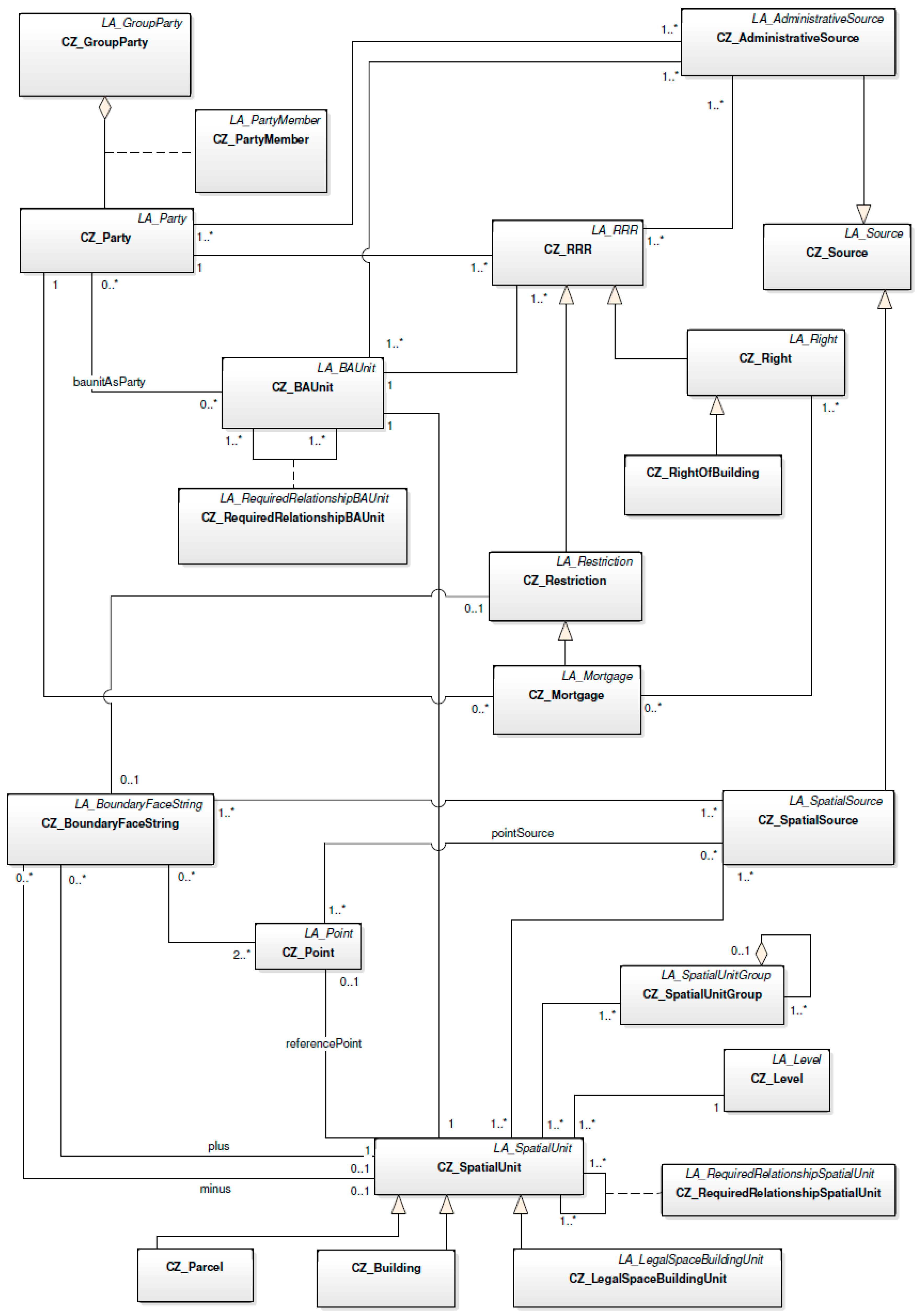
The relationships among these four main classes are illustrated in Figure 3.
Two or more parties can be grouped into a group party (CZ_GroupParty). In the Czech profile, the following three types of group parties are distinguished: family, association and baunitGroup. These values are enumerated within the CZ_GroupPartyType code list. There is also an association class CZ_PartyMember between CZ_Party and CZ_GroupParty. An instance of the class CZ_PartyMember is a party member. The sum of the shares of the group party members has to equal unity, wherein an attribute share (of the class CZ_PartyMember) is utilized in order to model the size of the share.
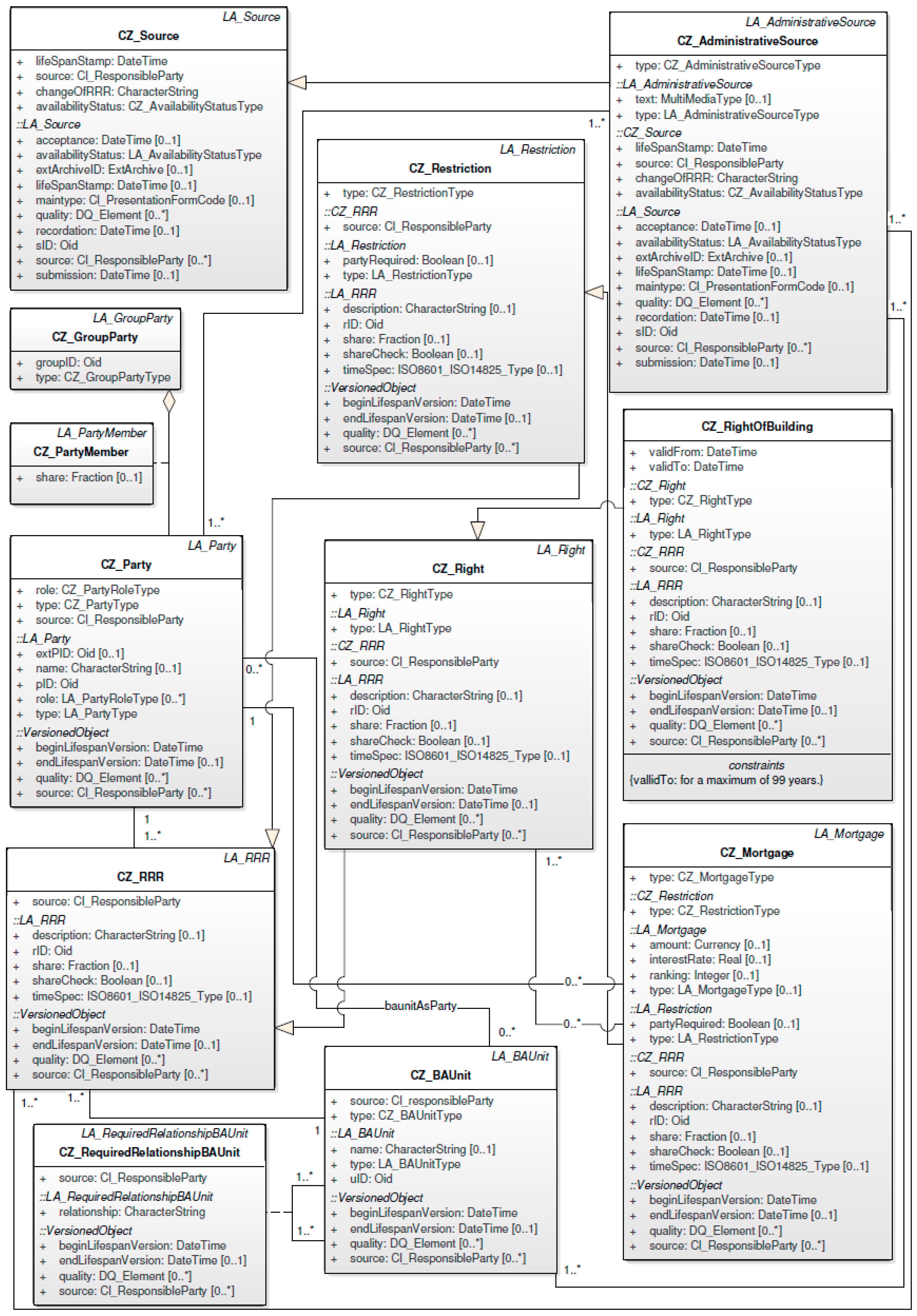
The class CZ_RRR consists of the subclasses CZ_Right and CZ_Restriction. As depicted in Figure 4, the class CZ_Right has a single subclass, CZ_RightOfBuilding. Based on this new instrument within Czech law, it will be possible to construct a building on land belonging to a third party. The right of building is a temporary right (with a 99 year maximum) established by an agreement between the land owner and the developer. From a legal point of view, the right of building as a whole is considered to be real estate and is subject to registration within the cadastre of real estate. The right of building can be subject to a transfer, mortgage, heritage or easement and is independent of the existence of the structure and can therefore be established even if the construction procedure has not yet begun. After expiry of the right of building, it can be theoretically prolonged, otherwise the building becomes a part of the land. The mandatory attribute validTo (of the class CZ_RightOfBuilding) is used for storing this information until the right of building is valid.
The class CZ_Restriction has a single subclass, CZ_Mortgage. The Czech cadastre was open to the public from the very beginning. This principle of openness proved to be very useful after mortgages were introduced in the cadastre. Figure 5 shows the principle of mortgage (modeled as CZ_Mortgage). Against the LA_Mortgage class, the attribute type (of the class CZ_Mortgage) is mandatory.
In the Czech LADM-based profile, administrative and spatial sources are modeled. For this purpose, there is an abstract class CZ_Source and its two subclasses CZ_AdministrativeSource and CZ_SpatialSource. The different real estate rights are based in certain transaction documents. This fact is represented by the association between CZ_RRR and CZ_AdministrativeSource. Furthermore, the mandatory attribute changeOfRRR (of the CZ_Source class) indicates whether the source document alters the registered right (i.e., restriction).
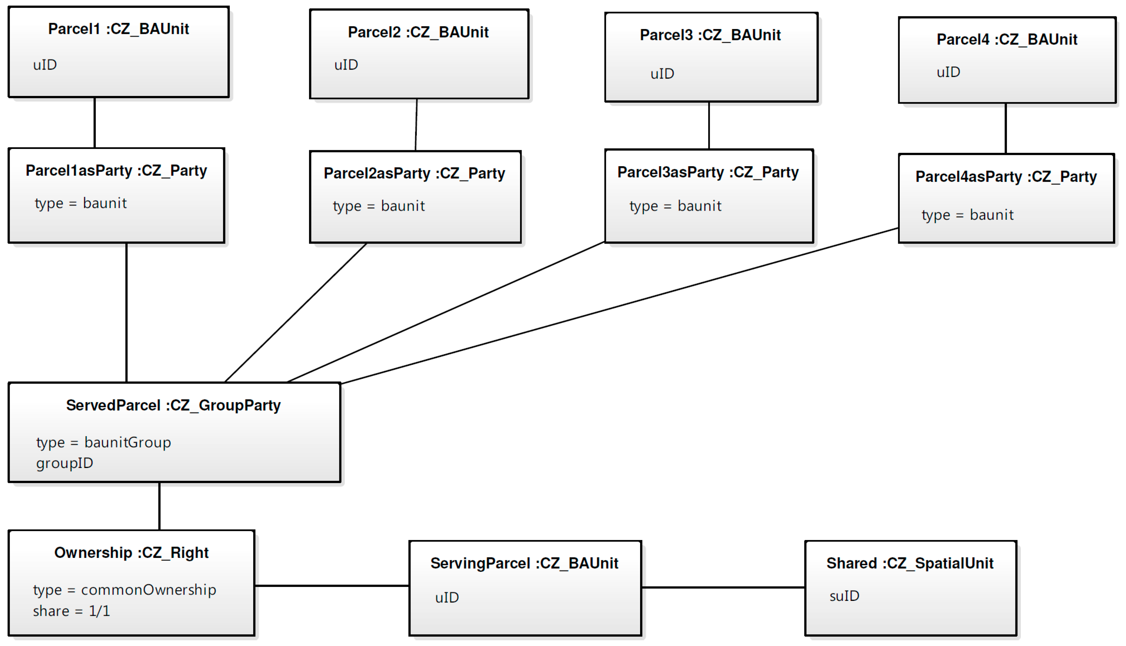
Regarding the relationship between the classes CZ_BAUnit and CZ_SpatialUnit, one instance of CZ_BAUnit (with the same RRRs attached) is associated with exactly one instance of CZ_SpatialUnit. CZ_BAUnit can also represent a party (where baunit represents a party). This approach is employed to model the supplementary co-ownership, which is a special type of ownership in that owners of their own property are allowed to utilize that property only in association with some shared property. The ownership of this shared property is known as supplementary co-ownership (according to the new Civil Code). Ownership of property as supplementary co-ownership is inextricably linked with the ownership of properties for whose use the property with supplementary co-ownership serves. The separate transfer of such property is not possible. One example includes a serving parcel as demonstrated in Figure 6, wherein the serving parcel provides access to neighboring parcels, and the serving parcel is not public, but is instead commonly owned by the neighboring parcels (modeled as baunit as party).
3.1. Ownership of a Building Unit
The ownership of a building unit is one of the most common situations within the cadastre. Figure 7 illustrates the principle of owning a building unit. The new Civil Code also regulates the ownership of building units, which was previously contained under a separate act (the Unit Ownership Act). To model the ownership of a building unit, the CZ_LegalSpaceBuildingUnit class was proposed, which is a subclass of the LA_LegalSpaceBuildingUnit class. A building unit, as defined by the former Unit Ownership Act, remains a separate piece of real estate and does not constitute a part of the land even in the case wherein the owner of the building unit and the owner of the land parcel is the same person. The former Unit Ownership Act and the new Civil Code provide a different view on the subject of the right of ownership to that building unit. According to the Unit Ownership Act, the right of ownership (de iure) consists of the following three separate components: a unit, a share of common parts of the building and a share of the land parcel. The new Civil Code considers the ownership of the unit and the share of common parts of the building as one inextricably linked element. Regarding the land parcel (from the new Civil Code point of view), in the case that the owner of both the building (containing the unit) and the land parcel is the same person, the land parcel then constitutes a part of the common parts of the building. The size of the share is determined by the size of the building unit in relation to the total area of all of the units. However, this is not the only method with which to compute the size of the share. The new Civil Code also makes it possible to consider, for example, the height of the ceiling. The greater the height of the ceiling, the more space that the owner would own, and thus, the share would be greater.
The code list CZ_BuildingUnitType helps to distinguish between types of building units. In the Czech cadastre, there are still many registered building units that are defined by the Unit Ownership Act. Thus, the CZ_BuildingUnitType code list also comprises the value of unitDefinedAccordingToTheUnitOwnershipAct, and the second possible value involved is unitDefinedAccordingToTheCivilCode.
The digital cadastral map displays neither the flat structure nor the spatial distribution of use rights. Rather, it only displays a schematic drawing illustrating the floor plans and a textual description of the flats (as required by legislation).
3.2. Building as a Component of the Land
After 1 January 2014, any building under ownership became a component of the land upon which it stands (i.e., Czech real estate law returned to the principle wherein structures are a part of the land upon which they are built, which is a superficies solo cedit principle). Buildings constructed on land (except for temporary buildings, utility lines and some other exemptions) are no longer the objects of law and only comprise a component of the land.
If the land owner and the building owner were two different persons at this time (1 January 2014), the building remained as real estate status, but the land owner was provided a pre-emptive right to the building and the building owner provided a pre-emptive right to the land. The building then became a component of the land when the building and the land were adjoined within the hands of a single owner. The building would not become part of the land if the building or the land was encumbered by a right in rem (i.e., a right associated with a property that is not based on any personal relationship). The CZ_Building class (as a subclass of the CZ_SpatialUnit) serves to model the buildings prior to the effectiveness of the new Civil Code, which means that such buildings are considered as separate entities (real estates) and not parts of the land. After 1 January 2014, when the new Civil Code was enacted, the buildings were not (due to the superficies sole cedit principle) further registered as separate real estates. Newly constructed buildings were not registered in the case when the owner of the land parcel and the owner of the building was the same person. However, a building was registered in the case when the owner of the parcel and the owner of the building were two different persons. For example, this situation could occur when a newly-constructed building is established with the right of building. The owner of the land parcel is then different from the owner of the building.
Figure 8 gives an overview of the legal component of the Czech country profile.
3.3. Spatial Units
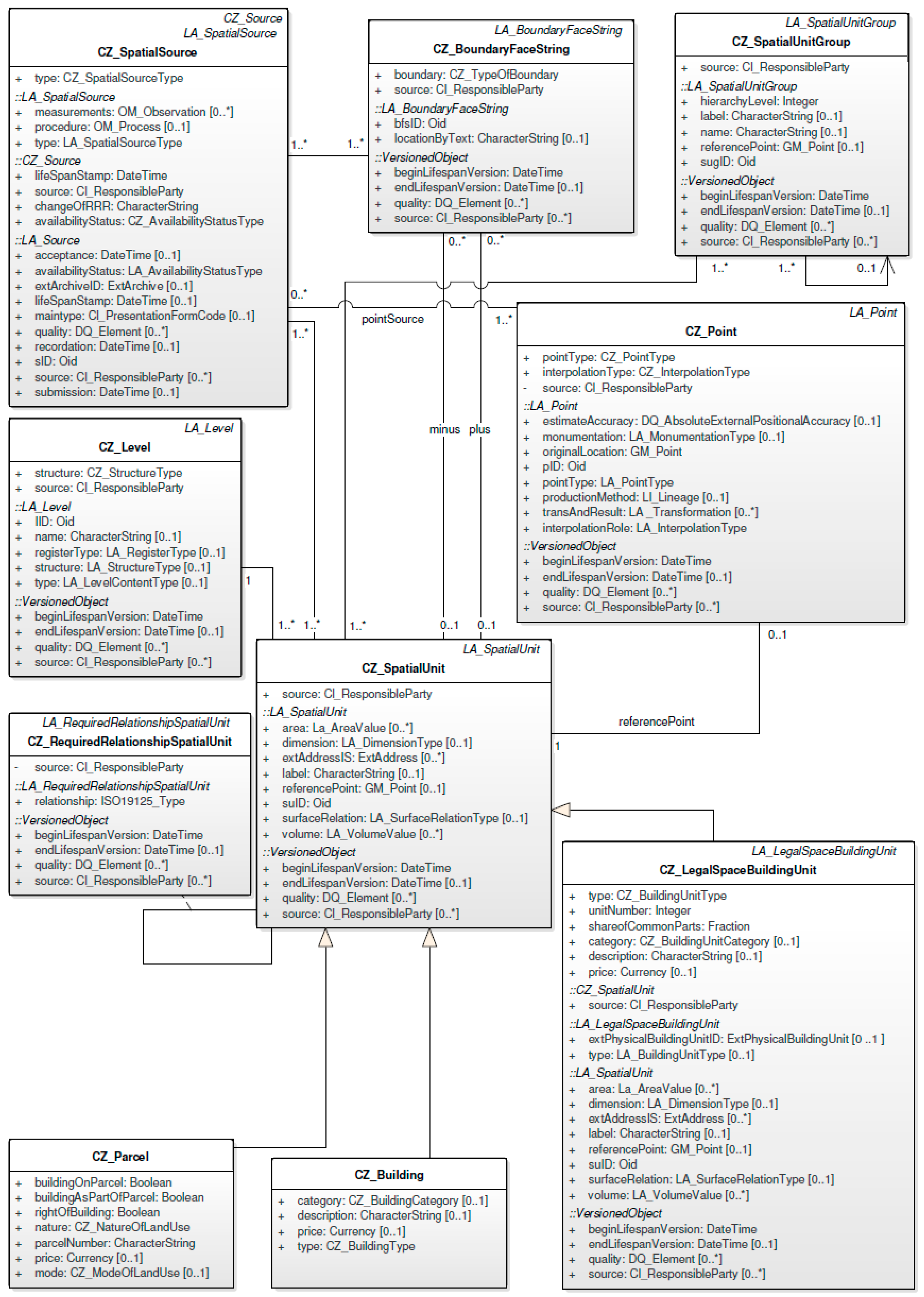
Spatial units are modeled using the CZ_SpatialUnit class and its three subclasses: CZ_Parcel, CZ_LegalSpaceBuildingUnits and CZ_Building. Regarding the geometry of spatial units, the Czech LADM country profile uses 2D topological-based spatial units. All topological boundaries (which are instances of the CZ_BoundaryFaceString class) are applied once in the positive and once in the negative direction, except in the event that the boundary is situated on the edge of the domain, in which case either the positive or the negative direction is used once (and the other is not used). All associated boundaries together form one or more non-intersecting rings that define at least one outer ring (with a counter-clockwise orientation) and optionally one or more inner rings (with a specified orientation). CZ_BoundaryFaceString is associated with the class CZ_Point and the class CZ_SpatialSource to document the origin of the geometry.
The Czech LADM profile also contains the CZ_Level class. Level is defined here as a set of spatial units characterized by geometric and topologic coherence. A spatial unit cannot be associated with more than one level. The different types of spatial units are indicated by the value of the structure attribute (i.e., of the CZ_Level class). At the conceptual level, there is a base level (Level 1) with topologically-defined spatial units (structure: CZ_StructureType = topological) and a Level 2 with polygon-based spatial units (structure: CZ_StructureType = polygon) that represent the protection zones.
The spatial units can be grouped into spatial unit groups (wherein the corresponding class for spatial unit groups is CZ_SpatialUnitGroup). An example of a spatial unit group is a cadastral unit consisting of parcels. The boundaries of parcels and territories (similar to a cadastral unit) are based on the topology and are hierarchically structured. In the case that a boundary of a parcel is identical to the boundary of another territory, the boundary shall be classified according to the following priorities (where the top values have the highest priority):
- state border,
- regional border,
- district border,
- municipality border,
- boundary of cadastral unit,
- boundary of a parcel.
These values are also included in the code list CZ_TypeOfBoundary (attribute boundary of the class CZ_BoundaryFaceString). Figure 9 gives an overview of the spatial component of the Czech country profile.
Table 1 contains the proposed CZ classes and the corresponding LADM classes. The relationships between all of the classes are illustrated in Figure 10. Table 2 provides an overview of the newly-defined CZ subclasses (CZ_Parcel, CZ_Building and CZ_RightOfBuilding). The CZ attributes and their corresponding CZ code lists are displayed in Table 3.
4. Conformity of the Czech Profile with ISO 19152
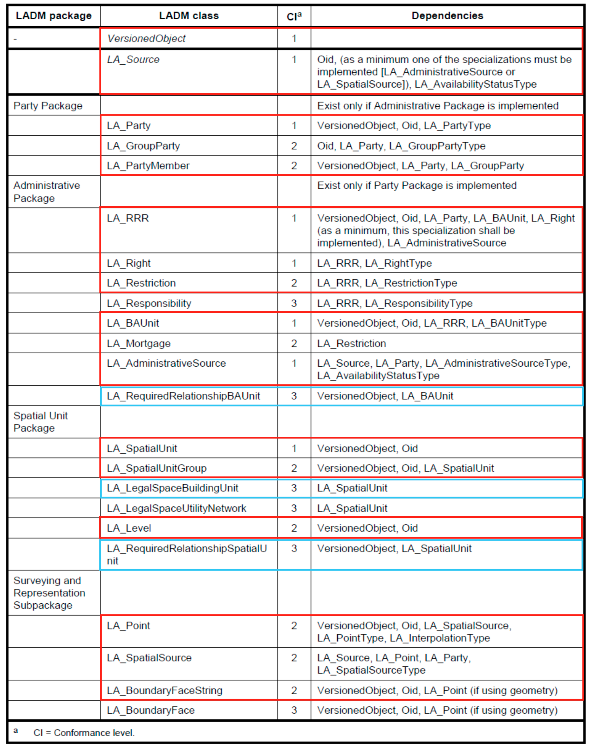
The LADM consists of three packages and one sub-package, each of which are specified with a conformance test in Annex A—Abstract Test Suite [1]. The following three conformance levels are specified per (sub)package: Level 1 (low level), Level 2 (medium level) and Level 3 (high level). Level 1 tests include the most basic classes per package, and Level 2 further includes the more common classes. Level 3 includes all of the classes. Any LADM-based profile claiming conformance to the ISO 19152 standard must satisfy the requirements of Annex A.
The possible manners in which to test this conformity are as follows:
(1) show an inherited structure between the LADM and the tested model (elements) or
(2) show a mapping of elements between the LADM and the tested model.
Figure 11 provides an overview of each package to check for LADM compliancy. The proposed country profile for the Czech Republic contains all of the necessary classes for conformance Level 2 (medium level) and meets all of the required dependencies as mentioned in Figure 11.
Furthermore, all necessary code lists (for Level 2) are designed within the Czech profile as depicted in Figure 12.
It should be noted that the Czech LADM-based profile also contains some Level 3 classes, e.g., the CZ_RequiredRelationshipSpatialUnit class (a subclass of LA_RequiredRelationshipSpatialUnit). Due to historical reasons, in some areas, the geometry of the spatial units is not sufficiently accurate, and therefore, there is a need for explicit spatial relationships. The union of the geometry of all parcels should cover the entire area. Neighboring parcels must not overlap, and no gaps are allowed between adjacent parcels. Furthermore, the boundary of a building must be inside the boundary of the parcel upon which the building is located, and the boundary of a building must not touch the boundary of the parcel.
Another Level 3 class contained within the Czech LADM-based profile is CZ_RequiredRelationshipBAUnit (a subclass of LA_RequiredRelationshipBAUnit). This class serves to model relationships (of a legal, temporal or spatial nature) between instances of LA_BAUnit. For example, only one building can be constructed on a parcel; however, that building can be built on one or many parcels. The next Level 3 class included in the Czech LADM-based profile is the LA_LegalSpaceBuildingUnit class, which serves to model building units. The remaining LADM Level 3 classes are not contained within the Czech LADM-based profile, e.g., the LADM class LA_Responsibility. Currently, there are no responsibilities registered, and therefore, these responsibilities are not included in the proposed country profile.
5. Conclusions
3D geospatial data are becoming an important attribute of geographical information systems. In the Czech Republic public administration spectrum, such 3D geospatial data are primarily utilized at the municipality level and mostly cover the area of a particular city. However, the Strategy for the Development of the Infrastructure for Spatial Information in the Czech Republic to 2020 was recently approved. This represents a government initiative that emphasizes the creation of a National Set of Spatial Objects, which is defined as the source of both guaranteed and reference 3D geographic data at the highest possible level of detail for selected objects covering the entire territory of the Czech Republic. This can also be a potential source of data for a 3D cadastre, especially regarding the legal components of buildings. Furthermore, the GeoInfoStrategy Action Plan recommends the use of the ISO 19152 standard as one of the source documents for obtaining the selected measurements. For example, ISO 19152 should be used for buildings in the register of passive infrastructure.
To enable a comparison between the ISO 19152 standard and the current cadastre data model, an LADM-based country profile was proposed. The profile considers the requirements of the new Civil Code and related legislation. Despite the fact that the new Civil Code explicitly considers the space both above and below the ground as a part of the land, the Czech cadastre still retains the 2D paradigm. The Czech LADM-based country profile contains all of the classes and code lists required for Level 2 compliance. Moreover, it also contains some Level 3 classes. The Czech cadastre is based on the registration of 2D parcels, and therefore (for example), the Level 3 class LA_BoundaryFace is not integrated into the Czech profile. If the necessity for the further development of 3D systems arises within the Czech cadastre, then the profile can be expanded precisely to support 3D parcels modeled using LA_BoundaryFace. Furthermore, with regard to the discussed utilities, the LADM offers the LA_LegalSpaceUtilityNetwork class, and consequently, the Czech LADM-based profile can be appropriately extended in a standardized manner in order to support the registration of legal components related to utilities.
Acknowledgments
The first author of the publication was supported by the project Sustainability support of the centre NTIS—New Technologies for the Information Society (LO1506) of the Czech Ministry of Education, Youth and Sports.
Author Contributions
Conflicts of Interest
The authors declare no conflicts of interest.
References
- ISO Online Browsing Platform (OBP). Available online: https://www.iso.org/obp/ui/#iso:std:iso:19152:ed-1:v1:en (accessed on 24 February 2017).
- Čada, V.; Janečka, K. The Strategy for the Development of the Infrastructure for Spatial Information in the Czech Republic. ISPRS Inter. J. Geo-Inf. 2016, 5, 33. [Google Scholar] [CrossRef]
- Čada, V.; Janečka, K. The Fundamental Spatial Data in the Public Administration Registers. Int. Arch. Photogramm. Remote Sens. Spatial Inf. Sci. 2016, 41. [Google Scholar] [CrossRef]
- Zobrazení Netypických Staveb v Katastru Nemovitostí. Available online: http://csgk.fce.vutbr.cz/Oakce/A98/prezentace/Olivova_KN16.pdf (accessed on 20 February 2017).
- Stoter, J.; van Oosterom, P. 3D Cadastre in an International Context. Legal, Organizational, and Technological Aspects; CRC Press: Boca Raton, FL, USA, 2006. [Google Scholar]
- Bydłosz, J. The application of the Land Administration Domain Model in building a country profile for the Polish cadastre. Land Use Policy 2015, 49, 598–605. [Google Scholar] [CrossRef]
- Vučić, N.; Markovinović, D.; Mičević, B. LADM in the Republic of Croatia-making and testing country profile. In Proceedings of the 5th FIG International Land Administration Domain Model Workshop 2013, Kuala Lumpur, Malaysia, 24–25 September 2013. [Google Scholar]
- Zulkifli, N.A.; Rahman, A.A.; Van Oosterom, P.; Choon, T.L.; Jamil, H.; Hua, T.Ch.; Seng, L.K.; Lim, Ch.K. The importance of Malaysian Land Administration Domain Model country profile in land policy. Land Use Policy 2015, 49, 649–659. [Google Scholar] [CrossRef]
- Lee, B.M.; Kim, T.J.; Kwak, B.Y.; Lee, Y.; Choi, J. Improvement of the Korean LADM country profile to build 3D cadastre model. Land Use Policy 2015, 49, 660–667. [Google Scholar] [CrossRef]
- Janečka, K.; Souček, P. Country profile for the cadastre of the Czech Republic based on LADM. In Proceedings of the 5th International FIG 3D Cadastre Workshop 2016, Athens, Greece, 18–20 October 2016. [Google Scholar]
- Ministry of the Interior of the Czech Republic. The Strategy for the Development of the Infrastructure for Spatial Information in the Czech Republic to 2020—Annex 3: Services Working with Spatial Data—Use Cases; Ministry of the Interior of the Czech Republic: Prague, Czech Republic, 2012.
- Döner, F.; Thompson, R.; Stoter, J.; Lemmen, Ch.; Ploeger, H.; van Oosterom, P.; Zlatanova, S. Solutions for 4D cadastre—With a case study on utility networks. Inter. J. Geograph. Inf. Sci. 2011, 25, 1173–1189. [Google Scholar] [CrossRef]
- Koeva, M.; Elberink, S.O. Challenges for updating 3D cadastral objects using LiDAR and image-based point clouds. In Proceedings of the 5th International FIG 3D Cadastre Workshop 2016, Athens, Greece, 18–20 October 2016. [Google Scholar]
- OGC City Geography Markup Language (CityGML) Encoding Standard. Version 2.0. Available online: http://www.opengis.net/spec/citygml/2.0 (accessed on 24 February 2017).
- Góźdź, K.; Pachelski, W.; van Oosterom, P.; Coors, V. The possibilities of using CityGML for 3D Representation of buildings in the cadastre. In Proceedings of the 4th International Workshop on 3D Cadastres 2014, Dubai, UAE, 9–11 November 2014. [Google Scholar]
- Seifert, M.; Gruber, U.; Riecken, J. Multidimensional cadastral system in germany. In Proceedings of the FIG Working Week 2016, Christchurch, New Zealand, 2–6 May 2016. [Google Scholar]
- Thompson, R.; van Oosterom, P.; Soon, K.H.; Priebbenow, R. A conceptual model supporting a range of 3D parcel representations through all stages: Data capture, transfer and storage. In Proceedings of the FIG Working Week 2016, Christchurch, New Zealand, 2–6 May 2016. [Google Scholar]
- Atazadeh, B.; Kalantari, M.; Rajabifard, A. Comparing three types of BIM-based models for managing 3D ownership interests in multi-level buildings. In Proceedings of the 5th International FIG 3D Cadastre Workshop 2016, Athens, Greece, 18–20 October 2016. [Google Scholar]
- Li, L.; Wu, J.; Zhu, H.; Duan, X.; Luo, F. 3D modeling of the ownership structure of condominium units. Comp. Environ. Urban Sys. 2016, 59, 50–63. [Google Scholar] [CrossRef]
- Rönsdorf, C.; Wilson, D.; Stoter, J. Integration of land administration domain model with CityGML for 3D cadastre. In Proceedings of the 4th International Workshop on 3D Cadastres 2014, Dubai, UAE, 9–11 November 2014. [Google Scholar]
- Çağdaş, V. An application domain extension to CityGML for immovable property taxation: A Turkish case study. Inter. J. Appl. Earth Observ. Geoinf. 2013, 21, 545–555. [Google Scholar] [CrossRef]
- Dsilva, M.G. A Feasibility Study on CityGML for Cadastral Purposes; Eindhoven University of Technology: Eindhoven, The Netherlands, 2009. [Google Scholar]
- Oldfield, J.; Van Oosterom, P.; Quak, W.; Van der Veen, J.; Beetz, J. Can data from BIMs be used as input for a 3D Cadastre? In Proceedings of the 5th International FIG 3D Cadastre Workshop 2016, Athens, Greece, 18–20 October 2016. [Google Scholar]
- Atazadeh, B.; Kalantari, M.; Rajabifard, A.; Ho, S.; Ngo, T. Building information modelling for high-rise land administration. Trans. GI. 2016, 21. [Google Scholar] [CrossRef]
- Kalantari, M.; Rajabifard, A. A roadmap to accomplish 3D cadastres. In Proceedings of the 4th International Workshop on 3D Cadastres 2014, Dubai, UAE, 9–11 November 2014. [Google Scholar]
Figure 1.
(a) Visualization of the underground construction of the archeological park in Pavlov, Czech Republic [4]; (b) entrance to the archeological park in Pavlov, Czech Republic (photo: Institute of Archeology of the Czech Academy of Sciences (CAS), Brno).
Figure 1.
(a) Visualization of the underground construction of the archeological park in Pavlov, Czech Republic [4]; (b) entrance to the archeological park in Pavlov, Czech Republic (photo: Institute of Archeology of the Czech Academy of Sciences (CAS), Brno).
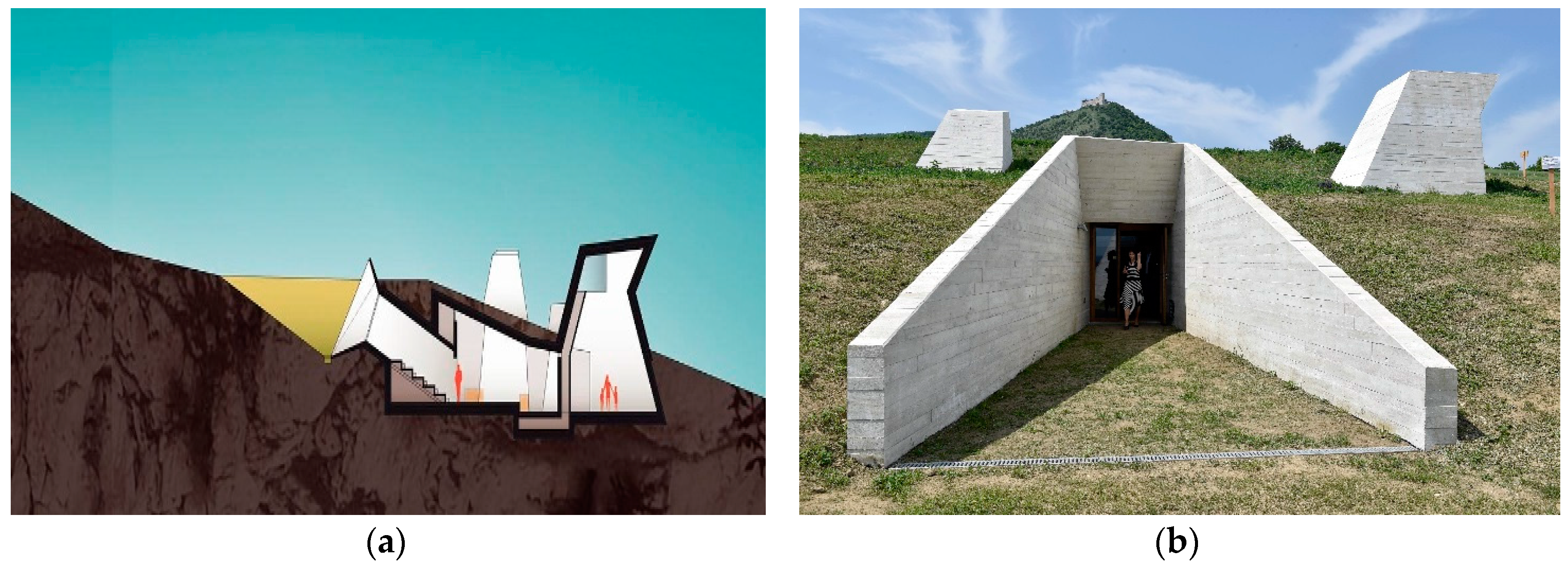
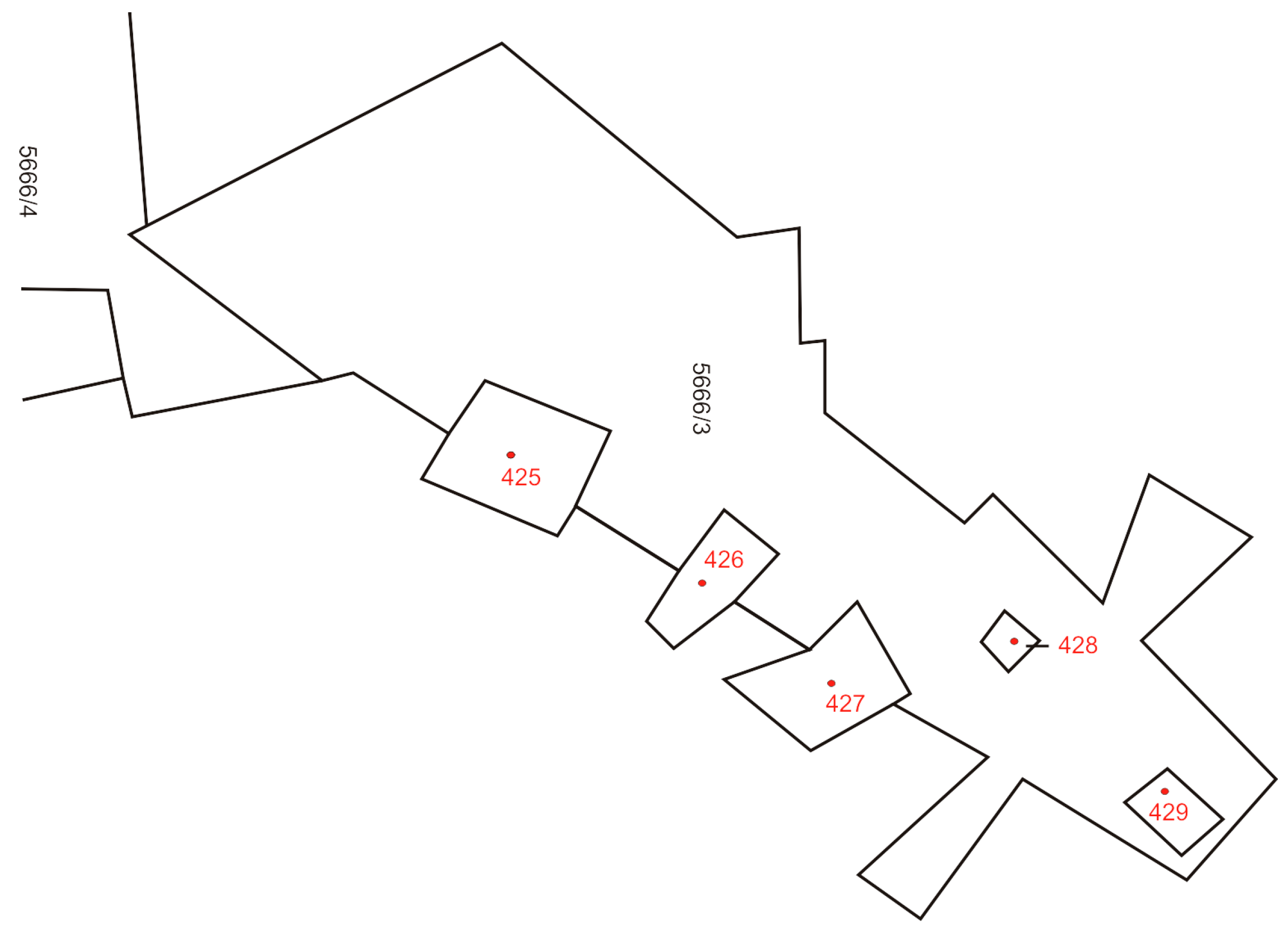
Figure 2.
2D visualization of the boundaries of underground construction for the archeological park in Pavlov. Every component of the construction located above ground has to exist on a separate building parcel (here, a total of five building parcels with bold red numbers are shown, after [4]).
Figure 2.
2D visualization of the boundaries of underground construction for the archeological park in Pavlov. Every component of the construction located above ground has to exist on a separate building parcel (here, a total of five building parcels with bold red numbers are shown, after [4]).

Figure 3.
The four fundamental classes of the Czech LADM-based profile.
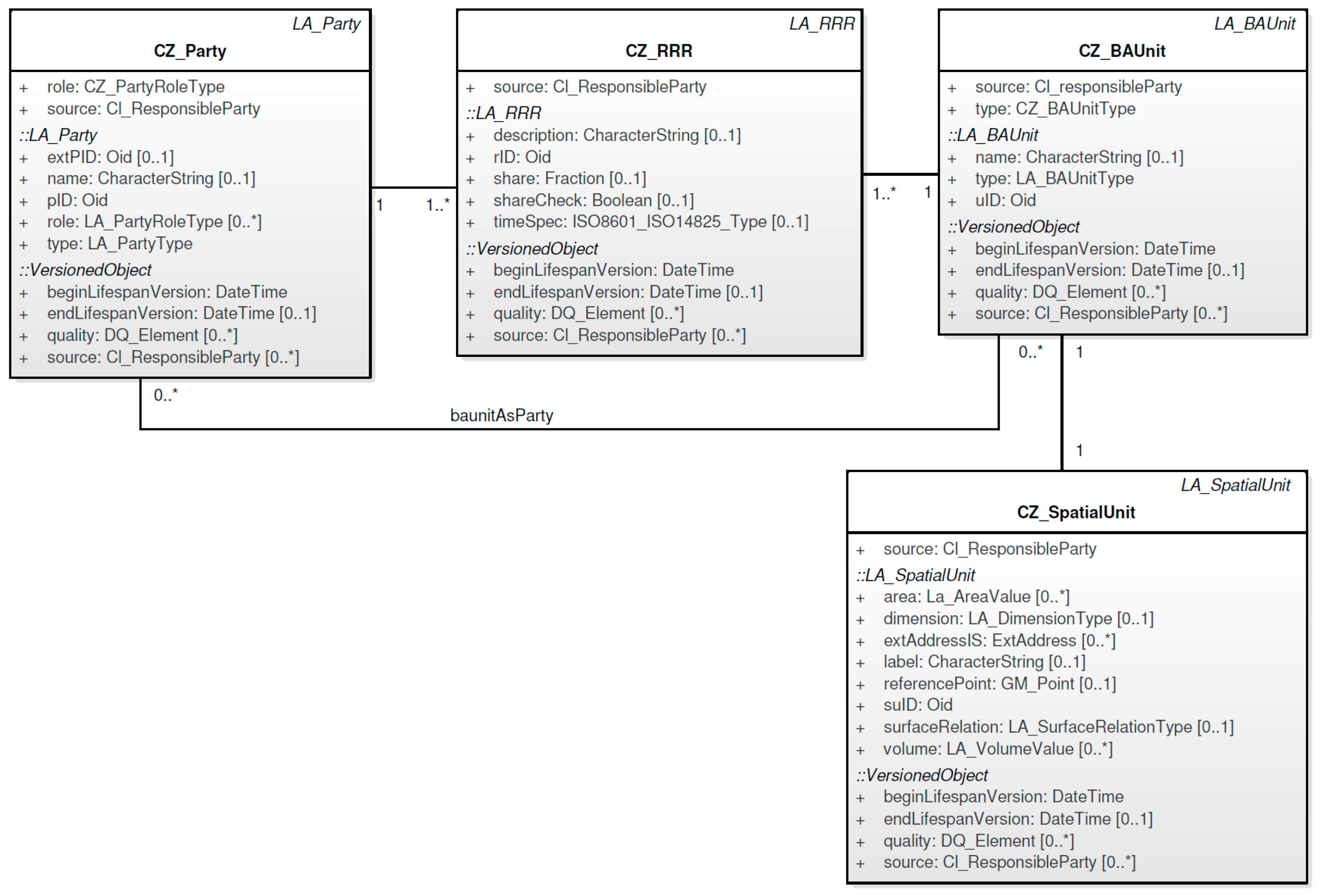
Figure 4.
Right of building. The right of building can be established for a maximum of 99 years.
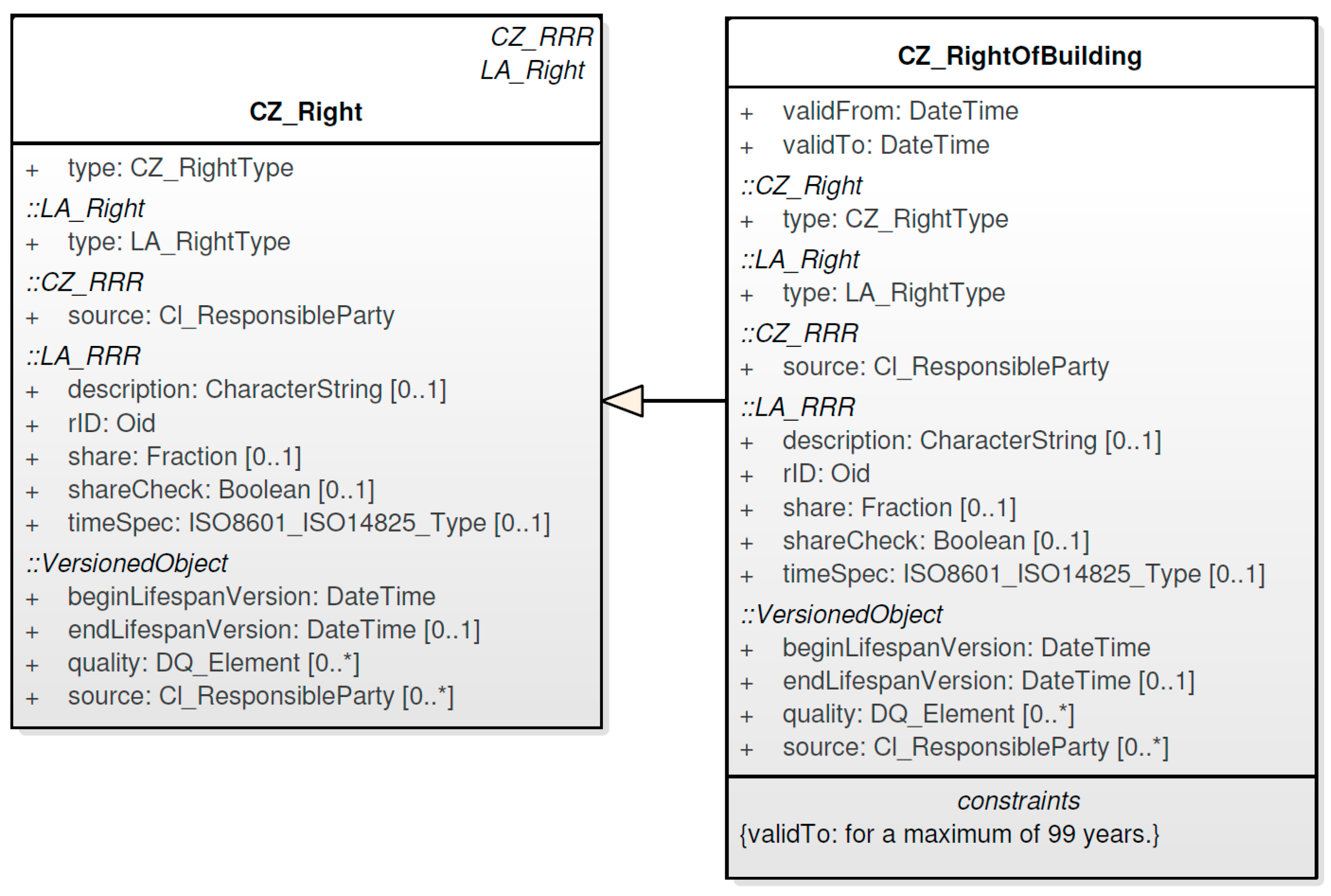
Figure 5.
An example of a mortgage.
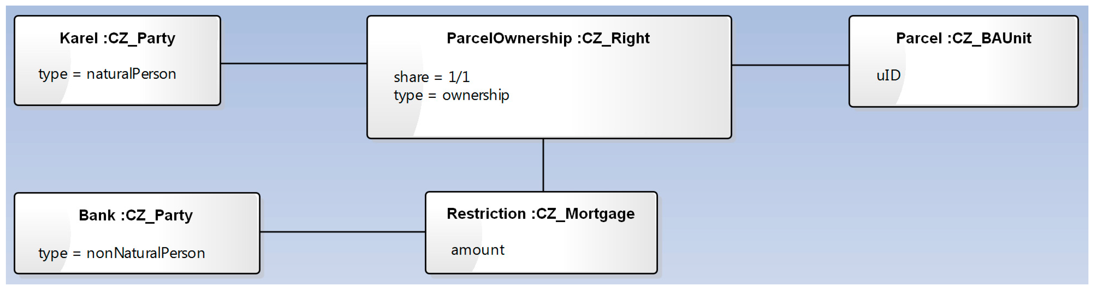
Figure 6.
An example of a serving parcel owned by neighbors.

Figure 7.
Ownership of a building unit. In principle, the owner has a right to the individual unit, a share of common components and a land parcel (but the owner of the unit and the owner of the land parcel could be different people).
Figure 7.
Ownership of a building unit. In principle, the owner has a right to the individual unit, a share of common components and a land parcel (but the owner of the unit and the owner of the land parcel could be different people).

Figure 8.
Overview of the legal component of the Czech country profile.

Figure 9.
Overview of the spatial component of the Czech country profile.

Figure 10.
The Czech LADM-based country profile. Due to the complexity of the model, only the names of classes are mentioned here. The classes with their attributes are illustrated in Figure 8 (legal component) and Figure 9 (spatial component).

Figure 11.
The LADM conformance requirements table [1]. The classes for conformance Level 2 are highlighted in red rectangles. The Czech profile also contains some Level 3 classes (highlighted in blue rectangles).
Figure 11.
The LADM conformance requirements table [1]. The classes for conformance Level 2 are highlighted in red rectangles. The Czech profile also contains some Level 3 classes (highlighted in blue rectangles).

Figure 12.
The code lists used in the Czech LADM-based country profile. In some cases, the presented code list contains only a subset of all of the possible values. For example, in reality, the LA_RightType code list contains more than 160 types of different types of right.
Figure 12.
The code lists used in the Czech LADM-based country profile. In some cases, the presented code list contains only a subset of all of the possible values. For example, in reality, the LA_RightType code list contains more than 160 types of different types of right.


Table 1.
The proposed CZ classes for the Czech cadastral profile and the corresponding LADM classes. The CZ classes with their attributes are illustrated in Figure 8 and Figure 9.
| LADM Package | CZ Class | Corresponding LADM Class |
|---|---|---|
| Party | CZ_Party | LA_Party |
| CZ_GroupParty | LA_GroupParty | |
| CZ_PartyMember | LA_PartyMember | |
| Administrative | CZ_RRR | LA_RRR |
| CZ_Right | LA_Right | |
| CZ_Restriction | LA_Restriction | |
| CZ_Mortgage | LA_Mortgage | |
| CZ_BAUnit | LA_BAUnit | |
| CZ_RequiredRelationshipBAUnit | LA_RequiredRelationshipBAUnit | |
| CZ_Source | LA_Source | |
| CZ_AdministrativeSource | LA_AdministrativeSource | |
| Spatial Unit | CZ_SpatialUnit | LA_SpatialUnit |
| CZ_LegalSpaceBuildingUnit | LA_LegalSpaceBuildingUnit | |
| CZ_SpatialUnitGroup | LA_SpatialUnitGroup | |
| CZ_Level | LA_Level | |
| CZ_RequiredRelationshipSpatialUnit | LA_RequiredRelationshipSpatialUnit | |
| Surveying andRepresentation | CZ_Point | LA_Point |
| CZ_SpatialSource | LA_SpatialSource | |
| CZ_BoundaryFaceString | LA_BoundaryFaceString |
Table 2.
The newly-added CZ subclasses for the Czech cadastral profile.
| CZ Class | New CZ Subclass |
|---|---|
| CZ_SpatialUnit | CZ_Parcel |
| CZ_Building | |
| CZ_Right | CZ_RightOfBuilding |
Table 3.
The CZ attributes and corresponding CZ code lists.
| CZ Class | CZ Attribute | CZ Code List |
|---|---|---|
| CZ_Party | type role | CZ_PartyType CZ_PartyRoleType |
| CZ_GroupParty | type | CZ_GroupPartyType |
| CZ_Right | type | CZ_RightType |
| CZ_Restriction | type | CZ_RestrictionType |
| CZ_Mortgage | type | CZ_MortgageType |
| CZ_BAUnit | type | CZ_BAUnitType |
| CZ_Source | availabilityStatus | CZ_AvalabilityStatusType |
| CZ_AdministrativeSource | type | CZ_AdministrativeSourceType |
| CZ_LegalSpaceBuildingUnit | type category | CZ_BuildingUnitType CZ_BuildingUnitCategory |
| CZ_Parcel | nature mode | CZ_NatureOfLandUse CZ_ModeOfLandUse |
| CZ_Building | type category | CZ_BuildingType CZ_BuildingCategory |
| CZ_Level | structure | CZ_StructureType |
| CZ_Point | pointType interpolationType | CZ_PointType CZ_InterpolationType |
| CZ_SpatialSourceType | type | CZ_SpatialSourceType |
| CZ_BoundaryFaceString | boundary | CZ_TypeOfBoundary |
© 2017 by the authors. Licensee MDPI, Basel, Switzerland. This article is an open access article distributed under the terms and conditions of the Creative Commons Attribution (CC BY) license (http://creativecommons.org/licenses/by/4.0/).
Share and Cite
MDPI and ACS Style
Janečka, K.; Souček, P. A Country Profile of the Czech Republic Based on an LADM for the Development of a 3D Cadastre. ISPRS Int. J. Geo-Inf. 2017, 6, 143. https://0-doi-org.brum.beds.ac.uk/10.3390/ijgi6050143
AMA Style
Janečka K, Souček P. A Country Profile of the Czech Republic Based on an LADM for the Development of a 3D Cadastre. ISPRS International Journal of Geo-Information. 2017; 6(5):143. https://0-doi-org.brum.beds.ac.uk/10.3390/ijgi6050143
Chicago/Turabian StyleJanečka, Karel, and Petr Souček. 2017. "A Country Profile of the Czech Republic Based on an LADM for the Development of a 3D Cadastre" ISPRS International Journal of Geo-Information 6, no. 5: 143. https://0-doi-org.brum.beds.ac.uk/10.3390/ijgi6050143
Note that from the first issue of 2016, this journal uses article numbers instead of page numbers. See further details here.