Exploring the Impact of Seasonality on Urban Land-Cover Mapping Using Multi-Season Sentinel-1A and GF-1 WFV Images in a Subtropical Monsoon-Climate Region


Abstract
:1. Introduction
2. Study Area and Datasets
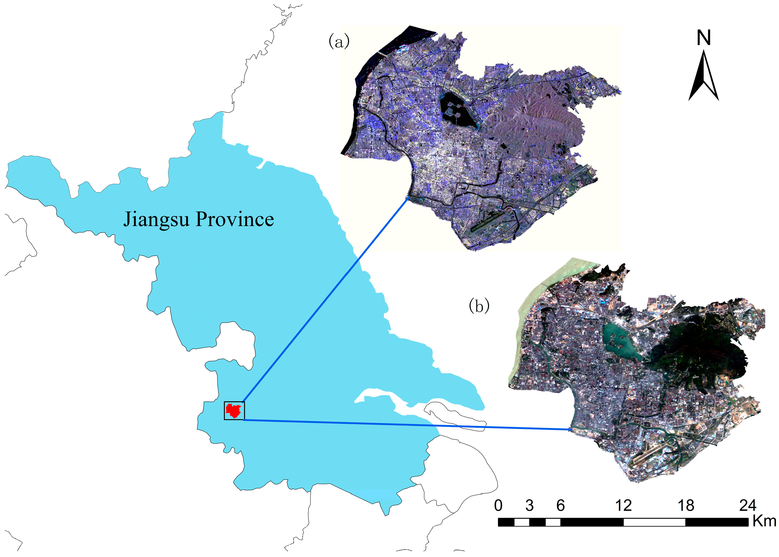
2.1. Study Area
2.2. Sentinel-1A Data
2.3. GF-1 Data
2.4. Ground Reference Data
3. Methods
3.1. Satellite Data Pre-Processing
3.2. Feature Sets
3.2.1. Texture Features
3.2.2. Coherence Features
3.2.3. Feature Combination
3.3. Classifiers
4. Results and Discussion
4.1. Analysis of Temporal Variables Used for Classification
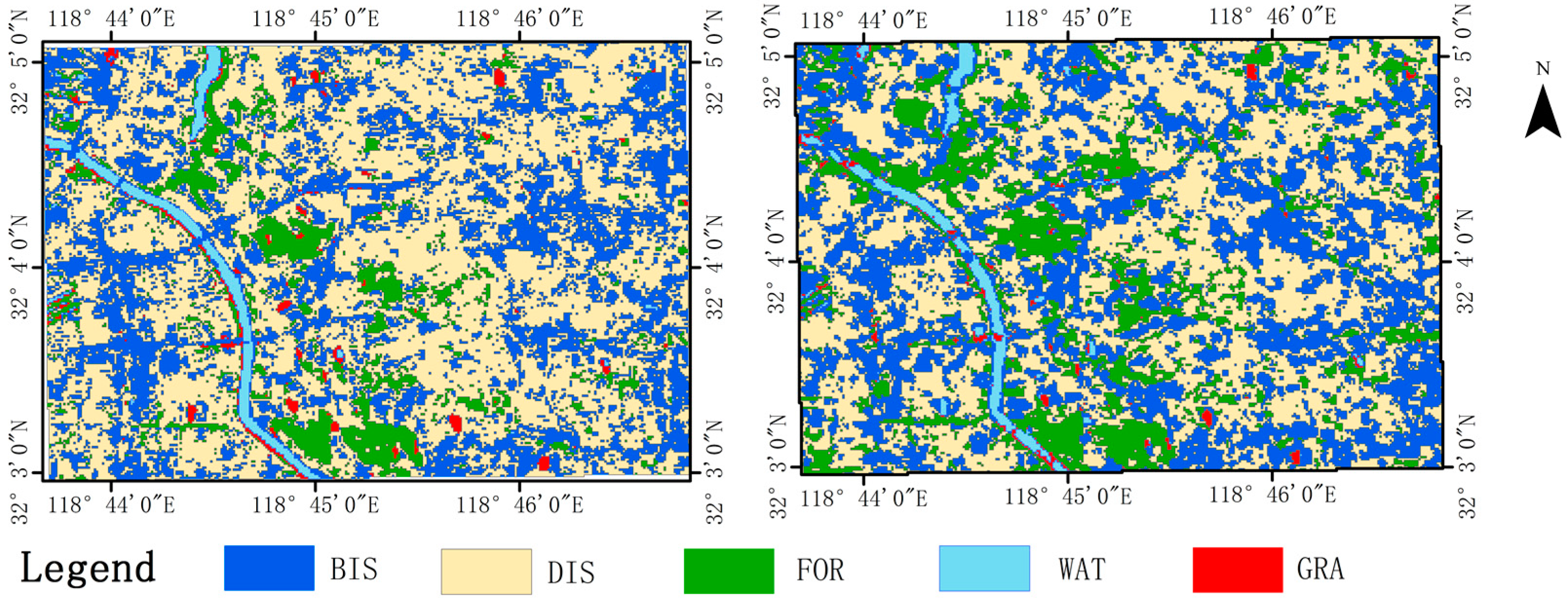
4.2. Urban Land-Cover Mapping
4.2.1. Classification Results Using a Single-Season Image
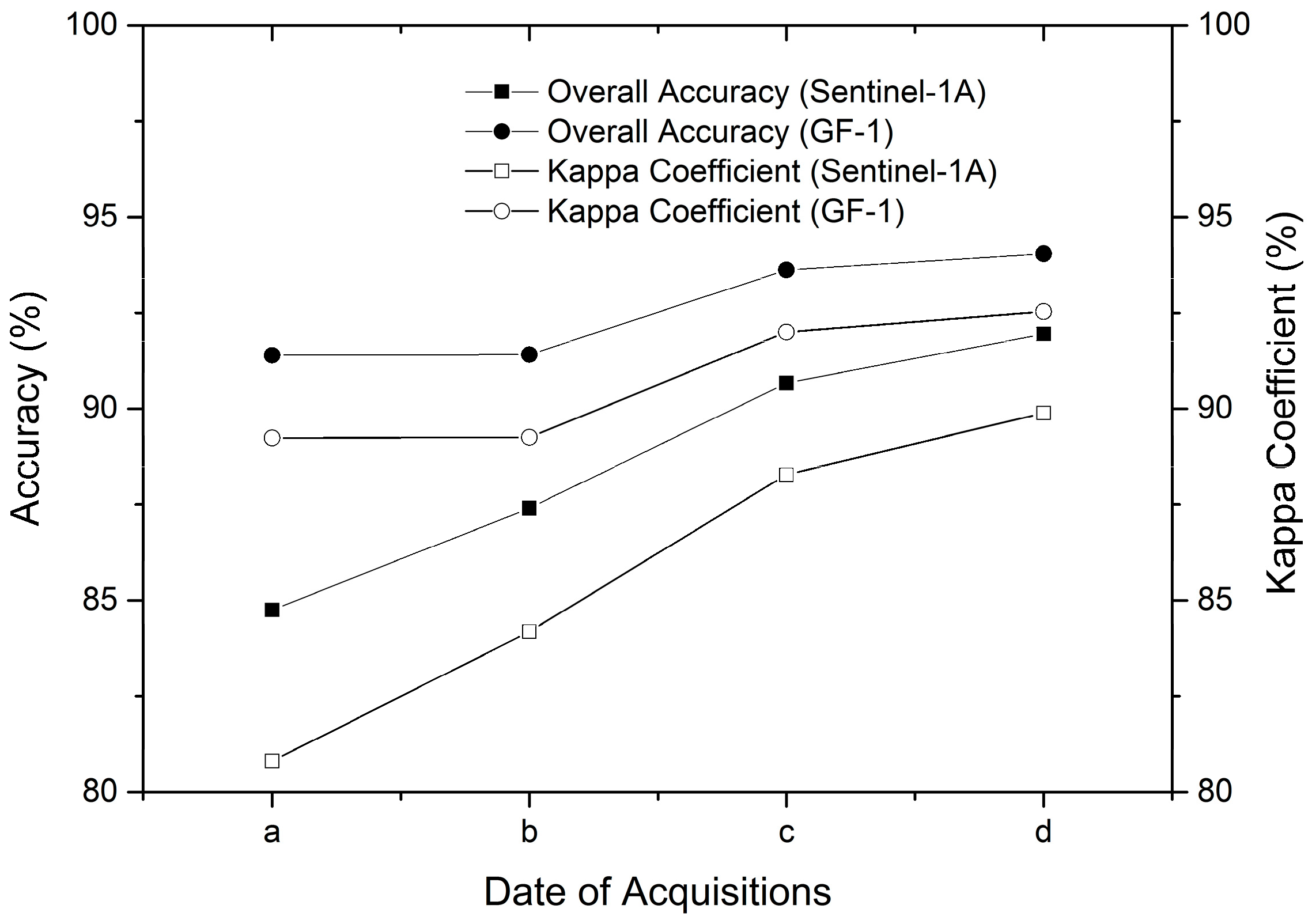
4.2.2. Incremental Classification Results Using Multi-Season Images
4.2.3. Classification Results Using Sentinel-1A and GF-1 WFV Images
4.2.4. Classification Results Using Different Sentinel-1A-Derived Information
5. Conclusions
Acknowledgments
Author Contributions
Conflicts of Interest
References
- Esch, T.; Thiel, M.; Schenk, A.; Roth, A.; Muller, A.; Dech, S. Delineation of urban footprints from TerraSAR-X data by analyzing speckle characteristics and intensity information. IEEE Trans. Geosci. Remote Sens. 2010, 48, 905–916. [Google Scholar] [CrossRef]
- Niu, X.; Ban, Y. Multi-temporal RADARSAT-2 polarimetric SAR data for urban land-cover classification using an object-based support vector machine and a rule-based approach. Int. J. Remote Sens. 2013, 34, 1–26. [Google Scholar] [CrossRef]
- Sun, Z.C.; Li, X.W.; Fu, W.X.; Li, Y.K.; Tang, D.S. Long-term effects of land use/land cover change on surface runoff in urban areas of Beijing, China. J. Appl. Remote Sens. 2013, 8, 084596. [Google Scholar] [CrossRef]
- Deng, C.; Wu, C. Examining the impacts of urban biophysical compositions on surface urban heat island: A spectral unmixing and thermal mixing approach. Remote Sens. Environ. 2013, 131, 262–274. [Google Scholar] [CrossRef]
- Weng, Q.H. Remote sensing of impervious surfaces in the urban areas: Requirements, methods, and trends. Remote Sens. Environ. 2012, 117, 34–49. [Google Scholar] [CrossRef]
- Van de Voorde, T.; Jacquet, W.; Canters, F. Mapping form and function in urban areas: An approach based on urban metrics and continuous impervious surface data. Landsc. Urban Plan. 2011, 102, 143–155. [Google Scholar] [CrossRef]
- Corbane, C.; Faure, J.-F.; Baghdadi, N.; Villeneuve, N.; Petit, M. Rapid urban mapping using SAR/optical imagery synergy. Sensors 2008, 8, 7125–7143. [Google Scholar] [CrossRef] [PubMed]
- Forkuor, G.; Conrad, C.; Thiel, M.; Ullmann, T.; Zoungrana, E. Integration of optical and synthetic aperture radar imagery for improving crop mapping in Northwestern Benin, West Africa. Remote Sens. 2014, 6, 6472–6499. [Google Scholar] [CrossRef] [Green Version]
- Oyoshi, K.; Tomiyama, N.; Okumura, T.; Sobue, S.; Sato, J. Mapping rice-planted areas using time-series synthetic aperture radar data for the Asia-RiCE activity. Paddy Water Environ. 2016, 14, 463–472. [Google Scholar] [CrossRef]
- Hong, S.; Jang, H.; Kim, N.; Sohn, H.-G. Water area extraction using RADARSAT SAR imagery combined with landsat imagery and terrain information. Sensors 2015, 15, 6652–6667. [Google Scholar] [CrossRef] [PubMed]
- Li, X.; Yeh, A.G. Multitemporal sar images for monitoring cultivation systems using case-based reasoning. Remote Sens. Environ. 2004, 90, 524–534. [Google Scholar] [CrossRef]
- Tan, W.; Liao, R.; Du, Y.; Lu, J.; Li, J. Improving urban impervious surface classification by combining Landsat and PolSAR images: A case study in Kitchener-Waterloo, Ontario, Canada. In Proceedings of the 2015 IEEE International Geoscience and Remote Sensing Symposium (IGARSS), Milan, Italy, 26–31 July 2015; pp. 1917–1920. [Google Scholar]
- Pellizzeri, T.M.; Gamba, P.; Lombardo, P.; Dell’Acqua, F. Multitemporal/multiband SAR classification of urban areas using spatial analysis: Statistical versus neural kernel-based approach. Geosci. Remote Sens. IEEE Trans. 2003, 41, 2338–2353. [Google Scholar] [CrossRef]
- Zhang, H.; Lin, H.; Li, Y. Impacts of feature normalization on optical and SAR data fusion for land use/land cover classification. IEEE Geosci. Remote Sens. Lett. 2017, 12, 1061–1065. [Google Scholar] [CrossRef]
- Lopez, C.V.; Anglberger, H.; Stilla, U. Fusion of very high resolution sar and optical images for the monitoring of urban areas. In Proceedings of the 2017 Joint Urban Remote Sensing Event (JURSE), Dubai, UAE, 6–8 March 2017. [Google Scholar]
- Teimouri, M.; Mokhtarzade, M.; Zoej, M.J.V. Optimal fusion of optical and sar high-resolution images for semiautomatic building detection. Gisci. Remote Sens. 2016, 53, 45–62. [Google Scholar] [CrossRef]
- Roychowdhury, K. Comparison between Spectral, Spatial and Polarimetric Classification of Urban and Periurban Landcover Using Temporal Sentinel-1 Images. In Proceedings of the XXIII ISPRS Congress, Prague, Czech Republic, 12–19 July 2016; pp. 789–796. [Google Scholar]
- Fard, T.A.; Hasanlou, M.; Arefi, H. Classifier fusion of high-resolution optical and synthetic aperture radar (SAR) satellite imagery for classification in urban area. In Proceedings of the ISPRS—International Archives of the Photogrammetry, Remote Sensing and Spatial Information Sciences, Tehran, Iran, 21 October 2014; pp. 25–29. [Google Scholar]
- Sonobe, R.; Tani, H.; Wang, X.; Kobayashi, N.; Shimamura, H. Discrimination of crop types with TerraSAR-X-derived information. Phys. Chem. Earth Parts A/B/C 2015, 83–84, 2–13. [Google Scholar] [CrossRef]
- Parihar, N.; Das, A.; Rathore, V.S.; Nathawat, M.S.; Mohan, S. Analysis of L-band SAR backscatter and coherence for delineation of land-use/land-cover. Int. J. Remote Sens. 2014, 35, 6781–6798. [Google Scholar] [CrossRef]
- Zhang, H.; Zhang, Y.; Lin, H. Urban land cover mapping using random forest combined with optical and SAR data. In Proceedings of the 2012 IEEE International Geoscience and Remote Sensing Symposium (IGARSS), Munich, Germany, 22–27 July 2012; pp. 6809–6812. [Google Scholar]
- Aimaiti, Y.; Kasimu, A.; Jing, G. Urban landscape extraction and analysis based on optical and microwave alos satellite data. Earth Sci. Inf. 2016, 9, 1–11. [Google Scholar] [CrossRef]
- Breiman, L. Random forests. Mach. Learn. 2001, 45, 5–32. [Google Scholar] [CrossRef]
- Vapnik, V.N.; Vapnik, V. Statistical Learning Theory; Wiley: Hoboken, NJ, USA, 1998. [Google Scholar]
- Ban, Y.; Jacob, A. Object-based fusion of multitemporal multiangle ENVISAT ASAR and HJ-1b multispectral data for urban land-cover mapping. IEEE Trans. Geosci. Remote Sens. 2013, 51, 1998–2006. [Google Scholar] [CrossRef]
- Zhu, Z.; Woodcock, C.E.; Rogan, J.; Kellndorfer, J. Assessment of spectral, polarimetric, temporal, and spatial dimensions for urban and peri-urban land cover classification using Landsat and SAR data. Remote Sens. Environ. 2012, 117, 72–82. [Google Scholar] [CrossRef]
- Deng, C.; Li, C.; Zhu, Z.; Lin, W.; Xi, L. Evaluating the impacts of atmospheric correction, seasonality, environmental settings, and multi-temporal images on subpixel urban impervious surface area mapping with Landsat data. ISPRS J. Photogramm. Remote Sens. 2017, 133, 89–103. [Google Scholar] [CrossRef]
- Scott, D.; Petropoulos, G.P.; Moxley, J.; Malcolm, H. Quantifying the physical composition of urban morphology throughout wales based on the time series (1989–2011) analysis of Landsat TM/ETM plus images and supporting GIS data. Remote Sens. 2014, 6, 11731–11752. [Google Scholar] [CrossRef] [Green Version]
- Tsutsumida, N.; Comber, A.; Barrett, K.; Saizen, I.; Rustiadi, E. Sub-pixel classification of MODIS EVI for annual mappings of impervious surface areas. Remote Sens. 2016, 8, 143. [Google Scholar] [CrossRef] [Green Version]
- Myint, S.W.; Okin, G.S. Modelling land-cover types using multiple endmember spectral mixture analysis in a desert city. Int. J. Remote Sens. 2009, 30, 2237–2257. [Google Scholar] [CrossRef]
- Schönfeldt, U.; Braubach, H. Electrical architecture of the SENTINEL-1 SAR antenna subsystem. In Proceedings of the 2008 7th European Conference on Synthetic Aperture Radar (EUSAR), Friedrichshafen, Germany, 2–5 June 2008. [Google Scholar]
- Jia, K.; Liang, S.; Gu, X.; Baret, F.; Wei, X.; Wang, X.; Yao, Y.; Yang, L.; Li, Y. Fractional vegetation cover estimation algorithm for chinese GF-1 wide field view data. Remote Sens. Environ. 2016, 177, 184–191. [Google Scholar] [CrossRef]
- Chen, X.; Xing, J.; Liu, L.; Li, Z.; Mei, X.; Fu, Q.; Xie, Y.; Ge, B.; Li, K.; Xu, H. In-flight calibration of GF-1/WFV visible channels using rayleigh scattering. Remote Sens. 2017, 9, 513. [Google Scholar] [CrossRef]
- Zhou, T.; Pan, J.; Zhang, P.; Wei, S.; Han, T. Mapping winter wheat with multi-temporal SAR and optical images in an urban agricultural region. Sensors 2017, 17, 1210. [Google Scholar] [CrossRef] [PubMed]
- Clevers, J. Assessing the Accuracy of Remotely Sensed Data—Principles and Practices, Russell G. Congalton, Kass Green, Second edition, CRC Press, Taylor & Francis Group, Boca Raton, FL (2009), 183 pp., Price: $99.95, ISBN: 978-1-4200-5512-2. Int. J. Appl. Earth Obs. Geoinform. 2009, 11, 448–449. [Google Scholar]
- Lillesand, T.M.; Kiefer, R.W.; Chipman, J.W. Remote Sensing and Image Interpretation, 5th ed.; Wiley: Hoboken, NJ, USA, 2015. [Google Scholar]
- Schuster, C.; Förster, M.; Kleinschmit, B. Testing the red edge channel for improving land-use classifications based on high-resolution multi-spectral satellite data. Int. J. Remote Sens. 2012, 33, 5583–5599. [Google Scholar] [CrossRef]
- Schuster, C.; Schmidt, T.; Conrad, C.; Kleinschmit, B.; Förster, M. Grassland habitat mapping by intra-annual time series analysis—Comparison of RapidEye and TerraSAR-X satellite data. Int. J. Appl. Earth Obs. Geoinform. 2015, 34, 25–34. [Google Scholar] [CrossRef]
- Arsenault, H.H. Speckle suppression and analysis for synthetic aperture radar images. Opt. Eng. 1985, 25, 636–643. [Google Scholar]
- Du, P.J.; Samat, A.; Waske, B.; Liu, S.C.; Li, Z.H. Random forest and rotation forest for fully polarized SAR image classification using polarimetric and spatial features. ISPRS J. Photogramm. Remote Sens. 2015, 105, 38–53. [Google Scholar] [CrossRef]
- Voisin, A.; Krylov, V.A.; Moser, G.; Serpico, S.B.; Zerubia, J. Classification of very high resolution sar images of urban areas using copulas and texture in a hierarchical markov random field model. IEEE Geosci. Remote Sens. 2013, 10, 96–100. [Google Scholar] [CrossRef]
- Gamba, P.; Aldrighi, M. Sar data classification of urban areas by means of segmentation techniques and ancillary optical data. IEEE J. Sel. Top. Appl. Earth Obs. Remote Sens. 2012, 5, 1140–1148. [Google Scholar] [CrossRef]
- Zhang, H.; Lin, H.; Li, Y.; Zhang, Y.; Fang, C. Mapping urban impervious surface with dual-polarimetric SAR data: An improved method. Landsc. Urban Plan. 2016, 151, 55–63. [Google Scholar] [CrossRef]
- Zhang, H.; Xu, R. Exploring the optimal integration levels between SAR and optical data for better urban land cover mapping in the pearl river delta. Int. J. Appl. Earth Obs. Geoinform. 2018, 64, 87–95. [Google Scholar] [CrossRef]
- Jia, K.; Wei, X.; Gu, X.; Yao, Y.; Xie, X.; Li, B. Land cover classification using Landsat 8 operational land imager data in Beijing, China. Geocarto Int. 2014, 29, 941–951. [Google Scholar] [CrossRef]
- Waske, B.; Benediktsson, J.A. Fusion of support vector machines for classification of multisensor data. IEEE Trans. Geosci. Remote Sens. 2007, 45, 3858–3866. [Google Scholar] [CrossRef]
- Navarro, A.; Rolim, J.; Miguel, I.; Catalao, J.; Silva, J.; Painho, M.; Vekerdy, Z. Crop monitoring based on SPOT-5 take-5 and Sentinel-1A data for the estimation of crop water requirements. Remote Sens. 2016, 8, 525. [Google Scholar] [CrossRef]
- Hutt, C.; Koppe, W.; Miao, Y.X.; Bareth, G. Best accuracy land use/land cover (LULC) classification to derive crop types using multitemporal, multisensor, and multi-polarization SAR satellite images. Remote Sens. 2016, 8, 15. [Google Scholar] [CrossRef]
- Jung, H.C.; Alsdorf, D. Repeat-Pass Multi-Temporal Interferometric Sar Coherence Variations with Amazon Floodplain and Lake Habitats; Taylor & Francis, Inc.: Melbourne, Australia, 2010; pp. 881–901. [Google Scholar]
- Liao, M.; Jiang, L.; Lin, H.; Li, D. Urban change detection using coherence and intensity characteristics of multi-temporal ERS-1/2 imagery. In Proceedings of the Fringe 2005 Workshop, Frascati, Italy, 28 November–2 December 2005. [Google Scholar]
- Weydahl, D.J. Analysis of ERS SAR coherence images acquired over vegetated areas and urban features. Int. J. Remote Sens. 2001, 22, 2811–2830. [Google Scholar] [CrossRef]
- O’Grady, D.; Leblanc, M. Radar mapping of broad-scale inundation: Challenges and opportunities in Australia. Stoch. Environ. Res. Risk Assess. 2014, 28, 29–38. [Google Scholar] [CrossRef]
- McNairn, H.; Champagne, C.; Shang, J.; Holmstrom, D.; Reichert, G. Integration of optical and synthetic aperture radar (SAR) imagery for delivering operational annual crop inventories. ISPRS J. Photogramm. Remote Sens. 2009, 64, 434–449. [Google Scholar] [CrossRef]
- Zhang, H.; Zhang, Y.; Lin, H. A comparison study of impervious surfaces estimation using optical and SAR remote sensing images. Int. J. Appl. Earth Obs. Geoinform. 2012, 18, 148–156. [Google Scholar] [CrossRef]
- Foody, G.M. Status of land cover classification accuracy assessment. Remote Sens. Environ. 2002, 80, 185–201. [Google Scholar] [CrossRef]
- Skakun, S.; Kussul, N.; Shelestov, A.Y.; Lavreniuk, M.; Kussul, O. Efficiency assessment of multitemporal C-Band Radarsat-2 intensity and Landsat-8 surface reflectance satellite imagery for crop classification in Ukraine. IEEE J. Sel. Top. Appl. Earth Obs. Romote Sens. 2016, 9, 3712–3719. [Google Scholar] [CrossRef]
- Wit, A.J.W.D.; Clevers, J.G.P.W. Efficiency and accuracy of per-field classification for operational crop mapping. Int. J. Remote Sens. 2004, 25, 4091–4112. [Google Scholar] [CrossRef]
- Inglada, J.; Vincent, A.; Arias, M.; Marais-Sicre, C. Improved early crop type identification by joint use of high temporal resolution SAR and optical image time series. Remote Sens. 2016, 8, 362. [Google Scholar] [CrossRef]
- Li, S.; Wang, Y.; Chen, P.; Xu, X.; Cheng, C.; Chen, B. Spatiotemporal fuzzy clustering strategy for urban expansion monitoring based on time series of pixel-level optical and SAR images. IEEE J. Sel. Top. Appl. Earth Obs. Remote Sens. 2017, 10, 1769–1779. [Google Scholar] [CrossRef]
- Zhang, Y.; Zhang, H.; Lin, H. Improving the impervious surface estimation with combined use of optical and SAR remote sensing images. Remote Sens. Environ. 2014, 141, 155–167. [Google Scholar] [CrossRef]
- Sprohnle, K.; Fuchs, E.M.; Pelizari, P.A. Object-based analysis and fusion of optical and SAR satellite data for dwelling detection in refugee camps. IEEE J. Sel. Top. Appl. Earth Obs. Romote Sens. 2017, 10, 1780–1791. [Google Scholar] [CrossRef]


| Season | Date | Incidence Angle | Product | Operational Model | Polarization |
|---|---|---|---|---|---|
| Spring | 14 April 2016 | 38.9 | SLC | IW | VV/VH |
| Summer | 12 August 2016 | 38.9 | SLC | IW | VV/VH |
| Autumn | 11 October 2016 | 39.0 | SLC | IW | VV/VH |
| Winter | 12 December 2016 | 39.0 | SLC | IW | VV/VH |
| Class | Number of Training Pixels | Number of Validation Pixels |
|---|---|---|
| WAT | 475 | 452 |
| FOR | 484 | 479 |
| BIS | 489 | 466 |
| DIS | 496 | 463 |
| GRA | 428 | 470 |
| ID | Abbreviation | Description |
|---|---|---|
| 1 | Sentinel-1A (Spr) | Spring Sentinel-1A (backscatter intensity, coherence, and texture images) |
| 2 | Sentinel-1A (Sum) | Summer Sentinel-1A (backscatter intensity, coherence, and texture images) |
| 3 | Sentinel-1A (Aut) | Autumn Sentinel-1A (backscatter intensity, coherence, and texture images) |
| 4 | Sentinel-1A (Win) | Winter Sentinel-1A (backscatter intensity, coherence, and texture images) |
| 5 | GF-1 (Spr) | Spring GF-1 |
| 6 | GF-1 (Sum) | Summer GF-1 |
| 7 | GF-1 (Aut) | Autumn GF-1 |
| 8 | GF-1 (Win) | Winter GF-1 |
| 9 | Sentinel-1A (Spr + Sum) | Spring and summer Sentinel-1A (backscatter intensity, coherence, and texture images) |
| 10 | Sentinel-1A (Spr + Sum + Aut) | Spring, summer and autumn Sentinel-1A (backscatter intensity, coherence, and texture images) |
| 11 | Sentinel-1A (Spr + Sum + Aut + Win) | Four seasons Sentinel-1A (backscatter intensity, coherence, and texture images) |
| 12 | GF-1 (Spr + Sum) | Spring and summer GF-1 |
| 13 | GF-1 (Spr + Sum + Aut) | Spring, summer and autumn GF-1 |
| 14 | GF-1 (Spr + Sum + Aut + Win) | Four seasons GF-1 |
| 15 | Sentinel-1A (Spr + Sum + Aut + Win) + GF-1 (Win) | Four seasons Sentinel-1A (backscatter intensity, coherence, and texture images) and winter GF-1 |
| 16 | T | Textures of four seasons Sentinel-1A |
| 17 | C | Coherence images of four seasons Sentinel-1A |
| 18 | VV + VH | Dual polarization (VV + VH) of four seasons Sentinel-1A |
| 19 | C + T | Textures and coherence images of four seasons Sentinel-1A |
| 20 | VV + VH + C | Dual polarization (VV + VH) and coherence images of four seasons Sentinel-1A |
| 21 | VV + VH + T | Dual polarization (VV + VH) and textures of four seasons Sentinel-1A |
| Sentinel-1A Data Pairs | Polarization | WAT | FOR | GRA | DIS | BIS |
|---|---|---|---|---|---|---|
| 14 April 2016–12 August 2016 | VV | 0.183 | 0.207 | 0.198 | 0.520 | 0.582 |
| VH | 0.163 | 0.188 | 0.178 | 0.442 | 0.529 | |
| 12 August 2016–11 October 2016 | VV | 0.178 | 0.202 | 0.286 | 0.597 | 0.603 |
| VH | 0.174 | 0.209 | 0.191 | 0.492 | 0.543 | |
| 11 October 2016–12 December 2016 | VV | 0.187 | 0.190 | 0.339 | 0.609 | 0.625 |
| VH | 0.166 | 0.194 | 0.216 | 0.545 | 0.572 |
| Class | 14 April 2016 | 12 August 2016 | 11 October 2016 | 12 December 2016 | ||||
|---|---|---|---|---|---|---|---|---|
| VV | VH | VV | VH | VV | VH | VV | VH | |
| FOR | −7.36 | −13.63 | −7.55 | −13.59 | −8.12 | −13.98 | −7.93 | −12.71 |
| WAT | −17.00 | −21.39 | −16.50 | −20.91 | −17.60 | −21.11 | −18.40 | −20.96 |
| GRA | −14.91 | −19.94 | −14.52 | −19.11 | −14.18 | −19.17 | −13.56 | −19.20 |
| DIS | −4.93 | −11.15 | −4.72 | −11.01 | −4.99 | −11.26 | −4.49 | −10.86 |
| BIS | −6.65 | −11.98 | −5.09 | −11.48 | −5.21 | −11.73 | −4.50 | −11.46 |
| Classifier | Season | F1 Measure (%) | Overall Accuracy (%) | Kappa | ||||
|---|---|---|---|---|---|---|---|---|
| WAT | FOR | BIS | DIS | GRA | ||||
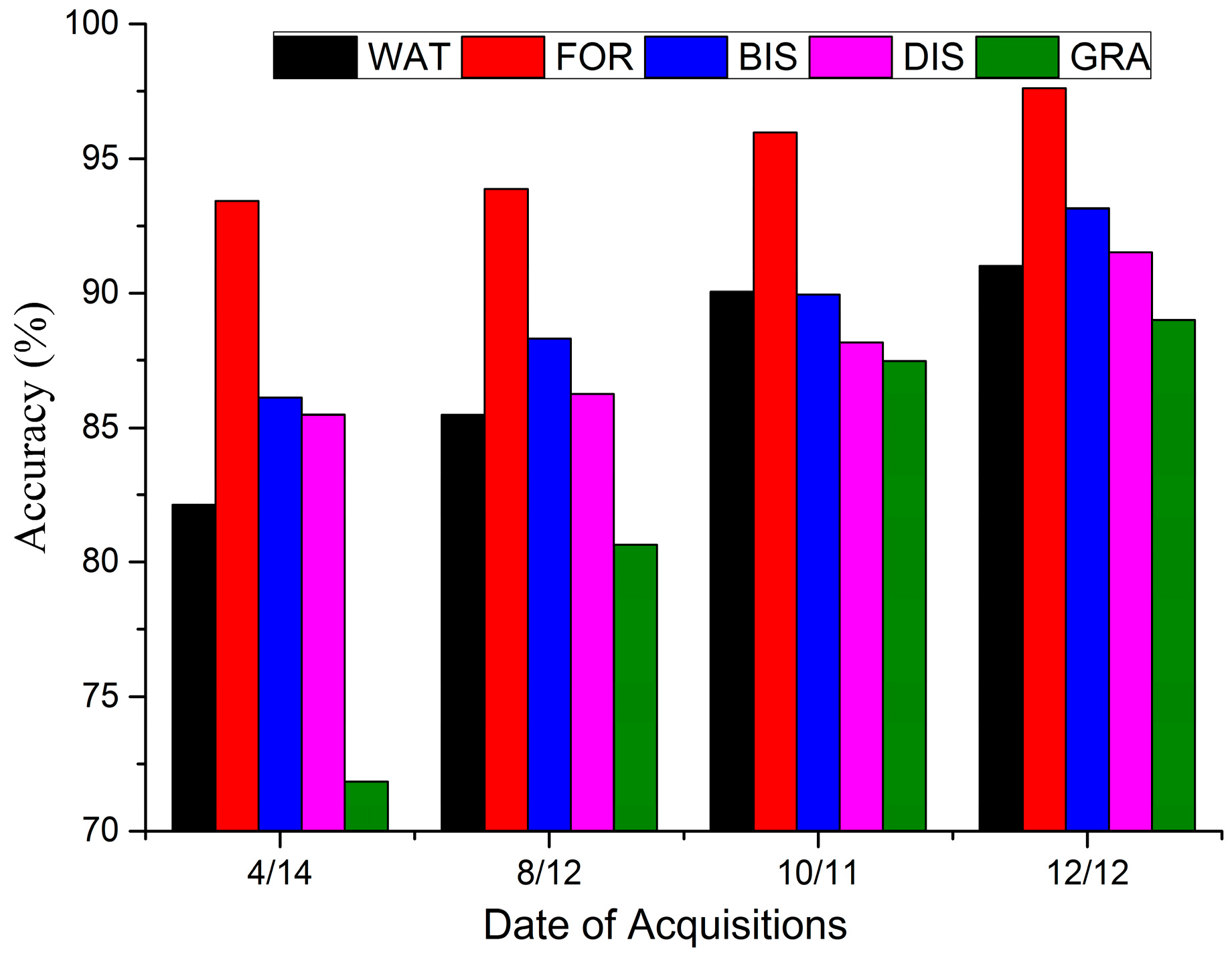
| RF | Spring | 82.14 | 93.42 | 86.11 | 85.48 | 71.84 | 84.75 | 0.8084 |
| Summer | 83.75 | 90.36 | 86.49 | 80.00 | 80.35 | 84.70 | 0.8078 | |
| Autumn | 85.00 | 90.80 | 87.14 | 83.33 | 82.14 | 86.12 | 0.8256 | |
| Winter | 86.08 | 91.86 | 88.57 | 84.03 | 87.18 | 87.82 | 0.8470 | |
| SVM | Spring | 75.41 | 91.23 | 74.42 | 75.19 | 53.33 | 76.20 | 0.7006 |
| Summer | 78.03 | 86.39 | 72.58 | 69.63 | 60.42 | 75.07 | 0.6865 | |
| Autumn | 82.84 | 88.13 | 75.59 | 72.00 | 74.07 | 79.60 | 0.7435 | |
| Winter | 82.63 | 89.77 | 78.12 | 73.02 | 78.90 | 81.30 | 0.7650 | |
| Classifier | Season | F1 Measure (%) | Overall Accuracy (%) | Kappa | ||||
|---|---|---|---|---|---|---|---|---|
| WAT | FOR | BIS | DIS | GRA | ||||
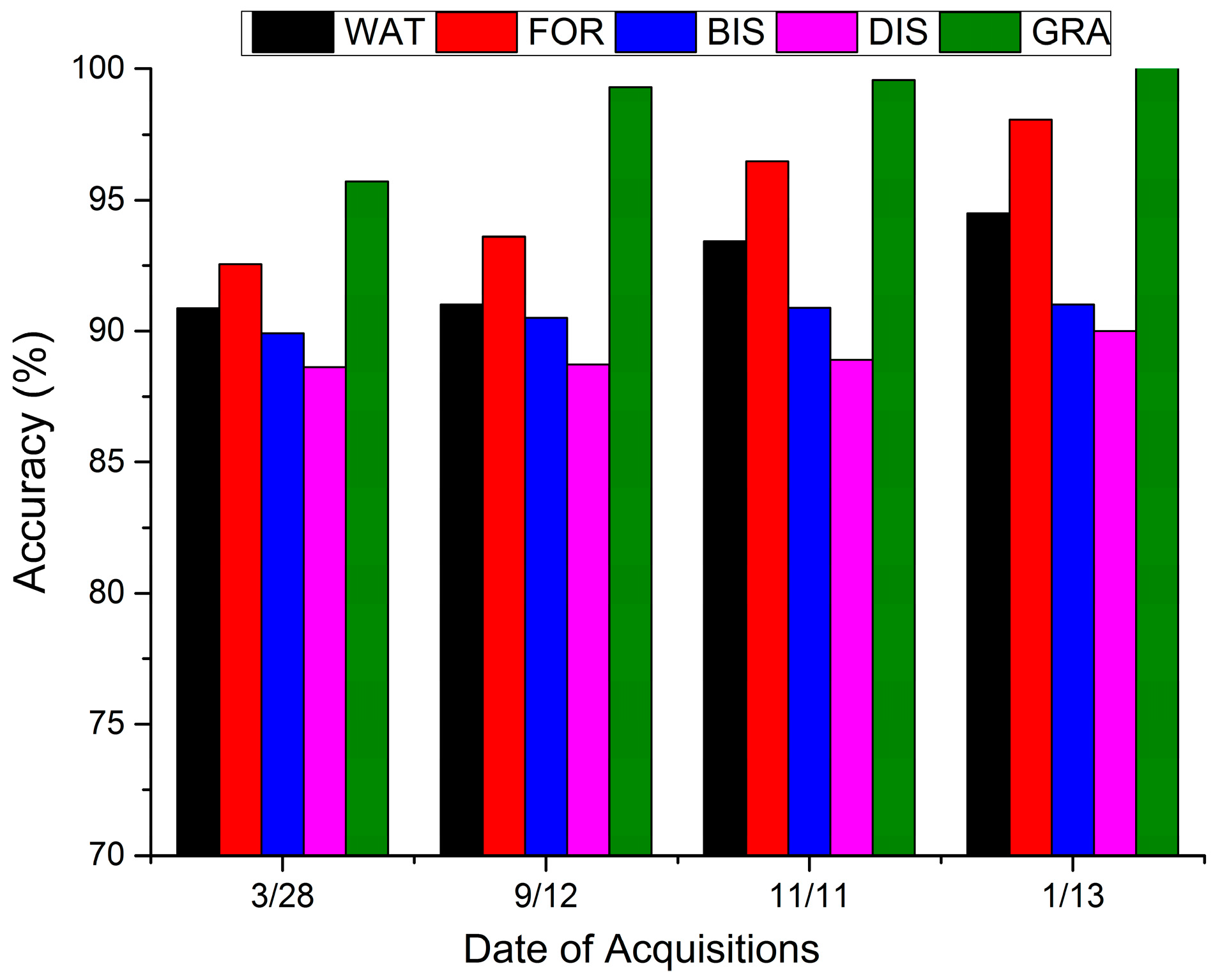
| RF | Spring | 90.86 | 92.55 | 89.91 | 88.63 | 95.71 | 91.39 | 0.8923 |
| Summer | 85.92 | 91.82 | 89.66 | 86.36 | 99.17 | 90.46 | 0.8807 | |
| Autumn | 92.40 | 95.65 | 89.76 | 88.71 | 97.71 | 92.94 | 0.9115 | |
| Winter | 92.40 | 95.65 | 90.37 | 89.43 | 97.71 | 93.22 | 0.9151 | |
| SVM | Spring | 91.43 | 91.55 | 82.48 | 79.01 | 93.87 | 87.23 | 0.8403 |
| Summer | 90.00 | 91.25 | 78.05 | 76.51 | 98.33 | 86.71 | 0.8338 | |
| Autumn | 93.83 | 96.85 | 80.65 | 79.39 | 96.97 | 90.11 | 0.8762 | |
| Winter | 93.83 | 96.85 | 82.93 | 81.81 | 96.97 | 90.96 | 0.8868 | |
| Accuracy Measure | WAT | FOR | Class | DIS | GRA |
|---|---|---|---|---|---|
| BIS | |||||
| F1 measure (%) | 98.65 | 98.04 | 92.31 | 90.37 | 99.94 |
| Overall accuracy (%)/Kappa | 96.02/0.9502 |
| ID | F1 Measure (%) | Overall Accuracy (%) | Kappa | ||||
|---|---|---|---|---|---|---|---|
| WAT | FOR | BIS | DIS | GRA | |||
| T | 86.63 | 87.27 | 85.52 | 75.81 | 86.95 | 84.70 | 0.8080 |
| C | 46.24 | 52.17 | 85.29 | 80.88 | 54.37 | 63.17 | 0.5373 |
| VV + VH | 86.08 | 84.37 | 73.53 | 70.68 | 79.66 | 79.32 | 0.7408 |
| C + T | 86.08 | 95.76 | 88.28 | 89.43 | 85.12 | 89.24 | 0.8650 |
| VV + VH + C | 86.45 | 94.05 | 87.88 | 86.15 | 80.99 | 87.54 | 0.8437 |
| VV + VH + T | 85.35 | 88.35 | 85.52 | 76.80 | 84.48 | 84.42 | 0.8046 |
© 2017 by the authors. Licensee MDPI, Basel, Switzerland. This article is an open access article distributed under the terms and conditions of the Creative Commons Attribution (CC BY) license (http://creativecommons.org/licenses/by/4.0/).
Share and Cite
Zhou, T.; Zhao, M.; Sun, C.; Pan, J. Exploring the Impact of Seasonality on Urban Land-Cover Mapping Using Multi-Season Sentinel-1A and GF-1 WFV Images in a Subtropical Monsoon-Climate Region. ISPRS Int. J. Geo-Inf. 2018, 7, 3. https://0-doi-org.brum.beds.ac.uk/10.3390/ijgi7010003
Zhou T, Zhao M, Sun C, Pan J. Exploring the Impact of Seasonality on Urban Land-Cover Mapping Using Multi-Season Sentinel-1A and GF-1 WFV Images in a Subtropical Monsoon-Climate Region. ISPRS International Journal of Geo-Information. 2018; 7(1):3. https://0-doi-org.brum.beds.ac.uk/10.3390/ijgi7010003
Chicago/Turabian StyleZhou, Tao, Meifang Zhao, Chuanliang Sun, and Jianjun Pan. 2018. "Exploring the Impact of Seasonality on Urban Land-Cover Mapping Using Multi-Season Sentinel-1A and GF-1 WFV Images in a Subtropical Monsoon-Climate Region" ISPRS International Journal of Geo-Information 7, no. 1: 3. https://0-doi-org.brum.beds.ac.uk/10.3390/ijgi7010003