Application of Open-Source Software in Community Heritage Resources Management


Department of Land Economics, Taiwan Institute for Governance and Communication Research, National Chengchi University, No. 64, Section 2, Zhi-Nan Road, Taipei 11605, Taiwan
ISPRS Int. J. Geo-Inf. 2018, 7(11), 426; https://0-doi-org.brum.beds.ac.uk/10.3390/ijgi7110426
Submission received: 19 July 2018
/
Revised: 3 October 2018
/
Accepted: 28 October 2018
/
Published: 31 October 2018
(This article belongs to the Special Issue Data Acquisition and Processing in Cultural Heritage)
Abstract
:In this paper, we present a case study of community heritage resources investigation and management, which was a collaborative project conducted by researchers and participants from rural communities. Geotagged photos were obtained using smart phones, and 360-degree panoramas were acquired using a robotic camera system. These images were then uploaded to a web-based GIS (WebGIS) developed using Arches-Heritage Inventory Package (HIP), an open-source geospatial software system for cultural heritage inventory and management. By providing various tools for resources annotation, data exploration, mapping, geovisualization, and spatial analysis, the WebGIS not only serves as a platform for heritage resources database management, but also empowers the community residents to acquire, share, interpret, and analyze the data. The results show that this type of collaborative working model between researcher and community can promote public awareness of the importance of heritage conservation and achieve the research goal more effectively and efficiently.
1. Introduction
The World Heritage Convention (1972) is a globally recognized legal instrument in heritage conservation, which has been implemented by many countries to protect lots of sites all over the world. Over the years, a growing awareness of the importance of the involvement of local communities and indigenous people has caused paradigmatic shift in practice and strategic planning for heritage conservation. Local communities not only contribute to the protection of biodiversity, specifically agrodiversity through sustainable land use, but also play an important role in maintaining and managing heritage, whether natural or cultural [1]. Previous researches in various countries, including Zimbabwe, Tanzania, South Africa, and other parts of the world reveal that active involvement of local people are essential for understanding the dynamics surrounding heritage sites and their management [2,3,4].
Many cultural heritage sites had been destroyed or damaged accidentally, deliberately, or by natural disaster in the past. To preserve cultural heritages for future generations, effective measures are needed for documenting them. Digital representations of cultural heritage can be archived, disseminated, and can serve as digital surrogates of the “real world”. They not only can be used for personal enjoyment but also enable visualization and scientific study without the need to have physical experience of the object or place. Emerging technologies such as digital photography, photogrammetry, panoramas, laser scanning, Global Positioning System (GPS), 3D modeling, distributed database, Web 2.0, and computer software for generating 2D and 3D information provide heritage professionals with tools that can acquire, process, and distribute heritage data more effectively and efficiently than decades ago [5]. However, CIPA Heritage Documentation, one of the oldest International Scientific Committees (ISC) of the International Council on Monuments and Sites (ICOMOS) and the International Society of Photogrammetry and Remote Sensing (ISPRS), pointed out some key problems that need further development, including duplication efforts, limited resources, and lack of uniformity. In particular, they suggested that the following issues merit more attention: open-source applications for heritage recording, use of mobile recording technologies to support documentation, usage of the CIDOC-CRM (International Committee for Documentation Conceptual Reference Model) and other ontology concepts for integration with heritage documentation activities, and use of controlled vocabularies for ensuring validity and consistency of inventory data [6,7].
In recent years, a wide range of sophisticated and freely available open-source software (OSS) have emerged, which are not only cost-saving but also ideal for developing cross-platform applications [8,9,10]. OSS is provided with free license that permits developers and users to study, modify, improve, and distribute the software. Many previous works have shown that this software is of great importance for various applications of the heritage field. Built with OSS, the Open Video Digital Library Toolkit (OVDLT) and CollectionSpace provide museums, libraries, and other institutions with web-based collections management software for archiving digital videos and digital replicas of cultural heritage objects. Constructed using OVDLT, the Open Video repository provides thousands of video clips from a variety of sources, including the U.S. Records and Archives Administration, National Aeronautics and Space Administration (NASA), and several universities and organizations [11,12,13,14,15]. Meyer et al. developed a web-based information system for managing and distributing cultural heritage data. The system allows management of diverse types of data and provides users with opportunity to explore and analyze data at spatial and temporal levels [16]. In a research project aiming to study the building techniques of the 13th–18th centuries in the Sardinia region (Italy), for managing enormous amount of data produced during the research, a spatial information system (SIS) was developed using a variety of OSS components, including PostgreSQL and PostGIS for building geodatabase, PHP and HTML for creating web-based data entry form, Geoserver for publishing geodatabase on the WWW through Open Geospatial Consortium (OGC) Web Map Service (WMS), Quantum GIS (QGIS) for accessing the database, and Leaflet JavaScript libraries for establishing the WebGIS [17,18].
Recent advancement of geographic information systems (GIS) technology offered powerful instruments for geodatabase management, spatial analysis, data exploration, geostatistical analysis, 2D and 3D visualization, and web mapping. More and more cultural heritage experts and authorities responsible for managing cultural heritage were actively engaged in the development of information system having GIS as the primary infrastructure component [19]. Mainly designed as integrated system for heritage inventory and management, two well-recognized systems exemplify the advantages of OSS, i.e., the South African Heritage Resources Information System (SAHRIS) launched by the South African Heritage Resources Agency (SAHRA) since 2012, and the Arches system jointly developed by Getty Conservation Institute (GCI) and World Monuments Fund (WMF) since 2013 [20,21,22,23,24].
SAHRIS was developed using Drupal, a very popular content management system (CMS) based on the LAMP stack, which is a combination of the Linux operating system, Apache web server, MySQL database, and PHP scripting language. Integrated with GIS tools and Geoserver, the system provides user-friendly heritage management tools to provincial heritage authorities, local planning authorities, and all bodies and custodians of heritage. SAHRIS consists of four main functions, namely, (1) to serve as an integrated heritage management system that facilitates online development applications, decision making, and planning process; (2) to serve as a national heritage sites repository populated with detailed information of identified sites; (3) to serve as a national collections management system that provides museums and heritage managers with software tools for working with digital inventories of their collections; and (4) to serve as a centralized platform for management of a comprehensive database of heritage objects for reporting and tracking heritage crime. By the end of December 2015, major achievements of the SAHRIS included: (1) a total of 8020 heritage cases had been processed, with 9462 heritage reports captured; (2) totally 42,456 sites had been processed by the system; (3) a total of 26,195 objects had been registered to the system; and (4) there were 260 stolen objects recorded on the system [20,25,26,27,28].
First released in October 2013, Arches is an OSS platform in the heritage conservation field providing a suite of powerful tools for compiling and managing inventories of heritages of various scales (national, regional, city or site). In addition to the professionals of Farallon Geographics, the primary developer of the software, many experts of related world-class organizations such as the English Heritage, WMF, GCI are heavily involved in its development [22]. Based on Django [29], a Python web framework that encourages rapid development of web-based applications, Arches is a flexible platform that can be tailored to meet different needs at low cost. Since its release, organizations worldwide are using Arches to build heritage resources management system, such as the HistoricPlacesLA deployed by the City of Los Angeles, the Philippine Heritage Map created by a Manila-based nonprofit organization, the Endangered Archaeology in the Middle East and North Africa project based at Oxford University, the Hong Kong Heritage Platform developed at the University of Hong Kong (HKU), and the Armed Forces Retirement Home (AFRH) Information and Resource Inventory System (IRIS) established by AFRH, a federal agency of the USA [22,30].
The current implementations of SAHRIS and Arches have proven that these two platforms are both very suitable for developing heritage resources management system. In comparison to SAHRIS and other implementations, one major advantage of Arches is that it provides source codes and documentations for developers, and it can be customized to meet individual needs. Moreover, to ensure data integrity and consistency, the Arches system adopts two CIDOC standards: (1) the revised International Core Data Standard for Archaeological and Architectural Heritage (CDS); and (2) the CIDOC Conceptual Reference Model. The former has been used as a basis to define the data fields in the generic version of the system while the latter has been used to provide the semantic framework [23,24,31]. The objective of this research was to develop a heritage inventory and management system for local communities with minimum cost. Considering the establishment of a repository of digital cultural resources that can be in line with CIDOC-CRM standard, we decided to implement Arches for a rural community in eastern Taiwan, in which the local residents are very proactive in preserving cultural and natural resources within their community.
2. Materials and Methods
2.1. Arches and Arches-HIP
The Arches project originated from MEGA (Middle Eastern Geodatabase for Antiquities), a web-based geospatial information system built with open-source tools [32,33]. Mainly sponsored by WMF and GCI, MEGA had demonstrated numerous superior features for cultural heritage management since its initial release in 2010. In addition to the support from several heritage authorities in the United States and Europe on researching the best practice and standards relevant to the development of the system, the project accepted substantial technical assistance from the English Heritage and Flanders Heritage Agency.
The version of Arches used in this study is v3.0, which was released in April 2015. However, Arches v4.0 had been released recently, and both versions can be downloaded from the official website of the Arches project [22]. Moreover, the Arches-HIP was launched simultaneously with Arches v3.0, which is an officially developed application of Arches. This application is designed to let users manage many types of heritage data and these types are mainly divided into six different resources in Arches-HIP [22,34]:
- Heritage Resources: objects that are culturally significant, for example, temple, shrines, artifact, tombstones, buildings, and monuments.
- Heritage Resource Groups: gathering of individual heritage resources that are best regarded as a group such as region, landscapes, historic zones, and graveyards.
- Activity: resources that occur over a period of time, which include religious celebrations, investigations, excavations, and restoration.
- Historic Event: culturally significant occurrences including battles, protests, natural disasters such as volcanic eruptions, earthquakes, and flooding.
- Actor: resources that are persons, groups of people, or organizations, e.g., architects, research teams, surveying firms, and association.
- Information Objects: objects that encode information such as a photo, documents, audio and video recordings, signs, drawings, and inscriptions.
Each resource provides a list of attributes that can be used to describe a heritage feature. Based on CIDOC-CRM, Arches employ ontology concept for naming and defining data types, properties, and the relationships between data entities that describe a resource. Arches-HIP requires the user to decide how to describe the resource information that will be entered into the system. An authority file is associated with an attribute such that its value is constrained by a list of controlled vocabularies. By using authority files to define the controlled vocabularies, it can be ensured that heritage data are created using just a list of predetermined terms. Table 1 shows a list of authority files included in Arches-HIP. For example, as shown in Table 2, to describe the condition of a building, controlled vocabularies can be a list of simple words such as “Good, Fair, Poor”, or thesauri in multi-lingual environment. Table 3 shows the content of measurement types authority file, which contains a list of predefined words that are used to describe measurement types including: length, depth, breadth, weight, tonnage, and height [34,35]. Defined in CRM, E55 class consists of concepts represented by terms from thesauri and controlled vocabularies used to describe and classify instances of CRM classes, and E57 class may denote properties of matter. Details of the class can be found at: http://www.cidoc-crm.org/Entity/e55-type/version-6.2 and http://www.cidoc-crm.org/Entity/e57-material/version-6.2.
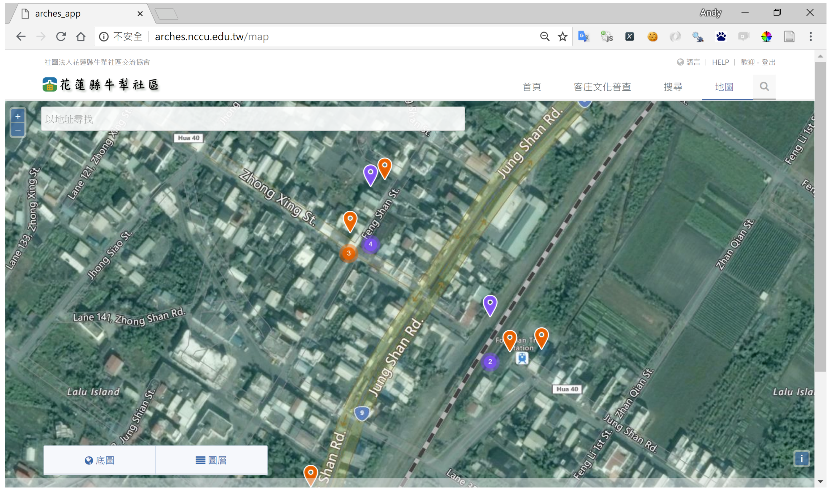
The Arches system is also designed to ensure the compliance with OGC standards and therefore is compatible with other desktop GIS applications such as ESRI ArcGIS, Google Earth, Quantum GIS, and online satellite imagery and map services including Google Maps, Microsoft Bing Maps, and OpenStreetMap [22,23,24]. With high compatibility, Arches is capable of displaying geographic data from different sources, which is very convenient for customizing the system to meet different needs. Since its release, Arches have been used by numerous organizations to develop various applications in heritage field. For example, the implementation of Arches at Nouli Community, Hualien County, Taiwan resulted in an online cultural heritage resource inventory system for better understanding the community and promoting public awareness of the importance of heritage conservation [22,36,37]. Figure 1 shows the map view of the system (http://arches.nccu.edu.tw/).
2.2. Other Related Open-Source Tools
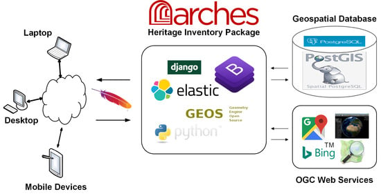
With many open-source geospatial software features, Arches is distributed under AGPLv3, which allows the users to copy and modify Arches without restriction and requires that derivative works to be distributed under AGPLv3. Arches is comprised of four basic components [22,34,35]:
- A Django-based web server tier, which is developed using Python programming language.
- A Bootstrap-based user interface using JavaScript and CSS (Cascading Style Sheets).
- A PostgreSQL relational database, and PostGIS, which is the spatial database extender for PostgreSQL.
- An Elasticsearch search engine, which can provide high performance full-text querying.
Developed using Python, Django is a high-level web framework that offers dozens of tools for creating web-based applications, including user authentication, content management, RSS feeds, and many more out of the box [29]. Owing to Django’s flexibility, we can create applications to seamlessly integrate with Arches. To produce dynamic statistical charts that can be put in web pages, we used pygal, a Python library for creating scalable vector graphics (SVG) [38].
In addition, GEOS (Geometry Engine-Open-Source) [39] is used to process geometries and provide spatial operations such as union, distance, intersection, buffer, area, and length. Given its open-source nature, Arches has flexibility of extension and customization if the user has appropriate software skills. In this research, we deployed the heritage inventory and management system using software listed in Table 4. All the software run on Linux operating system Ubuntu 14.04 LTS (Long Term Support).
2.3. Heritage Resource Data
The island of Taiwan is situated in East Asia with a population of more than 23 million. It was named Formosa when the Portuguese sailors sighted the island in the 16th century. Taiwanese aborigines of Austronesian race were the native inhabitants since prehistoric period. Most Han Chinese, mainly from southeastern provinces of China, immigrated to the island between the 16th and 18th century and dispersed in fluvial plains along the west coast. A few European settlements appeared on the southwestern coast, and northern areas in the 16th and 17th century. Between 1895 and 1945 the Japanese colonized Taiwan after defeating China in a war. Moreover, many mainlanders from various regions of China immigrated to Taiwan after World War II and the Chinese Civil War, a war fought between forces loyal to KMT-led government and the Communist Party of China. The influences of these different cultures are reflected in many aspects, including architecture, clothing, languages, artifacts, foods, agriculture, religion, and customs.
In the past few decades, Taiwan has experienced very rapid economic growth and large-scale development occurred in numerous industrial parks and urban areas as well as infrastructures such as high-speed railway, highways, and roads; however, rural villages remain largely undeveloped. Therefore, even though Taiwan has become a highly developed country in the world, cultural heritage resources are still quite abundant in rural communities such as agricultural and aquatic farm lands, tribal villages in uphill areas, and coastal settlements.
Similar to more economically developed countries, population aging has caused prominent impacts on Taiwan’s economy, education, health care, and social welfare policy [40]. Especially in rural communities, lack of working-age people not only affects the economic income of residents but also has adverse influences on social stability, and preservation of valuable cultural heritages. Consequently, in Taiwan, many community associations were established in recent years with an aim to help local inhabitants preserve heritage resources through inventory, protection, and educational programs. Heritages resources not only are helpful in learning local culture and landscape of a community, but also can preserve the sense of belonging and identity of people that can be passed on to the following generations. In many cases, preserving heritage resources even help generate more income to the community residents through well-developed tourism programs. However, due to limited available resources, only few of these community associations gained successful results. To address the needs of effective tools for community-oriented heritage resources management, this research aims to use Arches-HIP, a new open-source geospatial software system for cultural heritage inventory and management, to develop a spatial database and platform that can be applied to various rural communities.
The study site, Nouli Community, of this research is part of Hualien County located in eastern Taiwan with a total area of 24.6 km (Figure 2). Nouli Community is comprised of three villages, including Fengping, Fengli and Fengshan. During Japanese occupation (1895–1945), this area was named Toyota in 1911, therefore this name also appears in several places and documents ever since. Although the Japanese had withdrawn from Taiwan after World War II, a great number of Japanese architecture and construction were well preserved. Since Japanese established Toyota Village in 1913, Hakka, Holo, aborigines, Chinese mainlanders, and new immigrants (mostly from southeastern Asia countries) had moved to this area in different time periods spanning over a century. Hence, Nouli Community is a multi-ethnic inhabited village filled with diverse cultural characteristics. According to the statistics of July 2016, the total population of the Nouli Community is 4883. Similar to a typical rural area in Taiwan, the elderly population in the Nouli Community makes up a large proportion, with about one-sixth of the population being over the age of 65. The residents of Nouli Community mainly belong to three ethnic groups, including Hakka (65%), Holo Taiwanese (22%), and aborigines (11%). Chinese mainlanders and new immigrants totally amount to only 2% of the total population. Starting in 1996, in response to common problems in rural communities such as farmland fallow, population aging and outflows, members of several families formed an organization to launch a few programs aiming to boost economic development of the community. The organization later became the Nouli Community Development Association (NCDA) [41,42,43].
In the study site, most of the areas are less-developed agricultural lands, representing distinct cultural characteristics of various ethnics and eras, heritage resources such as monuments, shrines, artifacts, sites, and buildings dispersed in different places. To collect data about the heritage resources in the Nouli Community, this research used GPS logger and a mobile application, My Footprint, to record GPS coordinates and geotagged photos acquired using smart phones. My Footprint is a product of Madtec Solutions Limited and can run on various mobile devices installed with Android 2.2 and above. Moreover, a robotic camera system, LizardQ, was used to obtain high-resolution panoramic imageries.
3. Results
3.1. Heritage Resources Database
The heritage resources database resulted from collaborative efforts between the research team and the NCDA [43]. The main objective of this research is to inventory all types of resources that are of culturally significant values to the community such as natural and cultural landscape, historic sites, buildings, architectures, monuments, stelae, artifacts, and documents. For each resource, we recorded as much detail information as possible.
First, by using LizardQ we took photos of each site in seven viewing directions. Equipped with a Canon EOS 5D camera, LizardQ is capable of capturing high dynamic range (HDR) images. With different exposure times and ISO settings, six photos for each viewing direction were taken, with a total of 42 photos for each site. Panoramic images can then be created by stitching all photos together using Stitcher software provided by the vendor of LizardQ. The resulting images have very wide contrast range, therefore, the darkest and the brightest objects are all conspicuous in the same panoramic HDR image [44,45]. Figure 3 is a panorama of the Hakka Culture Exhibition Center in the community, with a resolution of 8000 × 4000 pixels. Panoramic images are placed on Google Cloud, and can be viewed from different perspectives using regular browsers running on smart phones, tablets, and desktop computers. Furthermore, 360 videos can be produced from these panoramas using image processing software, e.g., Photoshop, and GIMP (GNU Image Manipulation Program), a free and open-source image editor [46]. YouTube supports 360 videos with 24, 25, 30, 48, 50, or 60 frames per second. The video should be in equirectangular format with a 2:1 aspect ratio at a resolution of 7168 × 3584 or higher, up to 8192 × 4096. These video files must have certain metadata for 360 playback to be enabled. Provided by Google, a tool called “Spatial Media Metadata Injector” was used to insert metadata into these files, and then these videos were uploaded to YouTube [47]. A 360 video can be rotated by pressing WASD keys if it is played on computers in browsers such as Chrome, Firefox, Safari, MS Edge, or Opera. More interestingly, these videos can be viewed with head-mounted displays (HMDs), also referred to as “virtual reality (VR) headsets”, or “VR glasses”. For mobile device, users can wear a VR headset, such as Google Daydream View and Google Cardboard, to watch 360 videos in YouTube app [48]. Thus, the 360 videos can provide viewers with immersive virtual reality experience without the need to physically visit the sites. Figure 4 shows a 360 video viewed in YouTube app in VR mode.
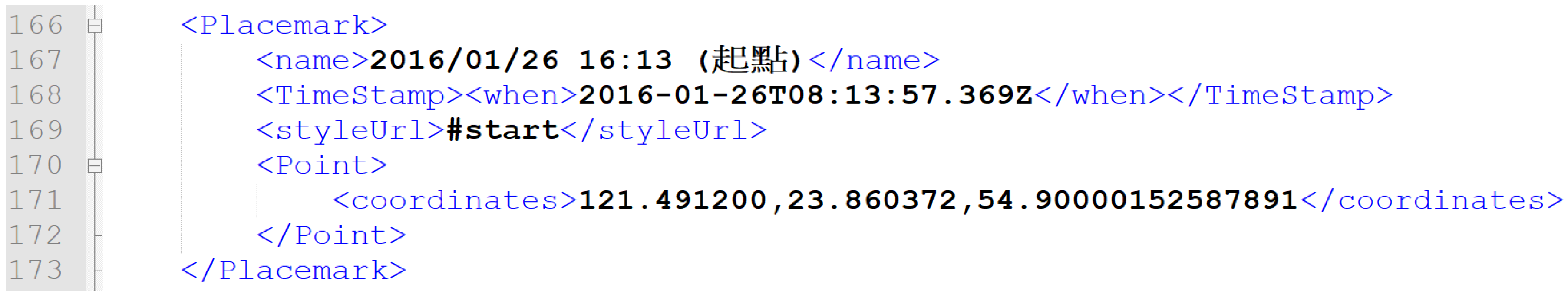
Second, several field investigations were conducted by the researchers and NCDA to collect data about the heritage sites. The location of each site was recorded using My Footprint mobile application and then exported as Google KML (Keyhole Markup Language) format. Based on XML (Extensible Markup Language) standard, KML uses tag-based structure to describe features, including placemarks, descriptions, ground overlays, paths, and polygons [49]. For example, Figure 5 depicts a placemark described in tags, including “name”, “TimeStamp”, “when”, “styleUrl”, “Point”, and “coordinates”. Through interviews with local people and assistance of NCDA, we also collected maps, photographs, documents, stories, reports, and other related data downloaded from official websites of government agencies. For this research we documented a total of 188 heritage resources in Nouli Community, and entering all the attribute data that describe each heritage would take much time and caution to assure data quality. Therefore, a more effective and reliable measure was needed to facilitate construction of heritage database.
Third, to ensure data quality, we used Microsoft Excel to input field data into spreadsheets, and collaborated with NCDA to validate the data before entering them into the Arches-HIP system. By using Python scripts developed by the researcher, the GPS coordinates were extracted from KML files and then integrated with the resources investigation report provided by NCDA. For areal features, we used Quantum GIS to digitize the boundaries of sites using orthoimages. Figure 6 shows a spreadsheet used for entering heritage resource data, including site IDs, names, town IDs, description, and geometries such as points and polygons. Several worksheets were created for entering pertinent data, e.g., photographs, panoramas, ethnic groups, township, and population. In addition, relationships between resources were indicated in these worksheets.
The last step of data processing involved entering heritage resource data into the Arches-HIP system. Adopting the CIDOC-CRM ontological model, Arches-HIP uses a set of controlled vocabularies, defined in authority files, to ensure data consistency. It also provides Reference Data Manager for the users to interactively define the terms to be used for controlled vocabularies, and Resource Data Manager to let user enter resource data into the system manually [23,34,35]. However, entering attribute data of 188 heritage resources manually not only takes much time but also is prone to errors.
Arches-HIP allows user to create inventory database in three ways: (a) manually enter data using data entry form of Resource Data Manager: it is easy to use; however, it is inefficient and prone to errors if data volume is large; (b) import from a GIS shapefile: can import geometry and attribute; however, it is not suitable if the attributes are complicated, such as multiple names for a heritage resource; (c) import from text file in “arches” format: the attribute data is defined in plain text, and allows to import very sophisticated datasets, e.g., heritage data with complex attributes such as multiple geometry types, names. More details about how to create heritage inventory database can be found in Arches-HIP Documentation [34]. For this research, we decided to develop software tools to automate creation of “arches” file for importing data into Arches-HIP so that our work can be applied to future implementation for other communities more easily.
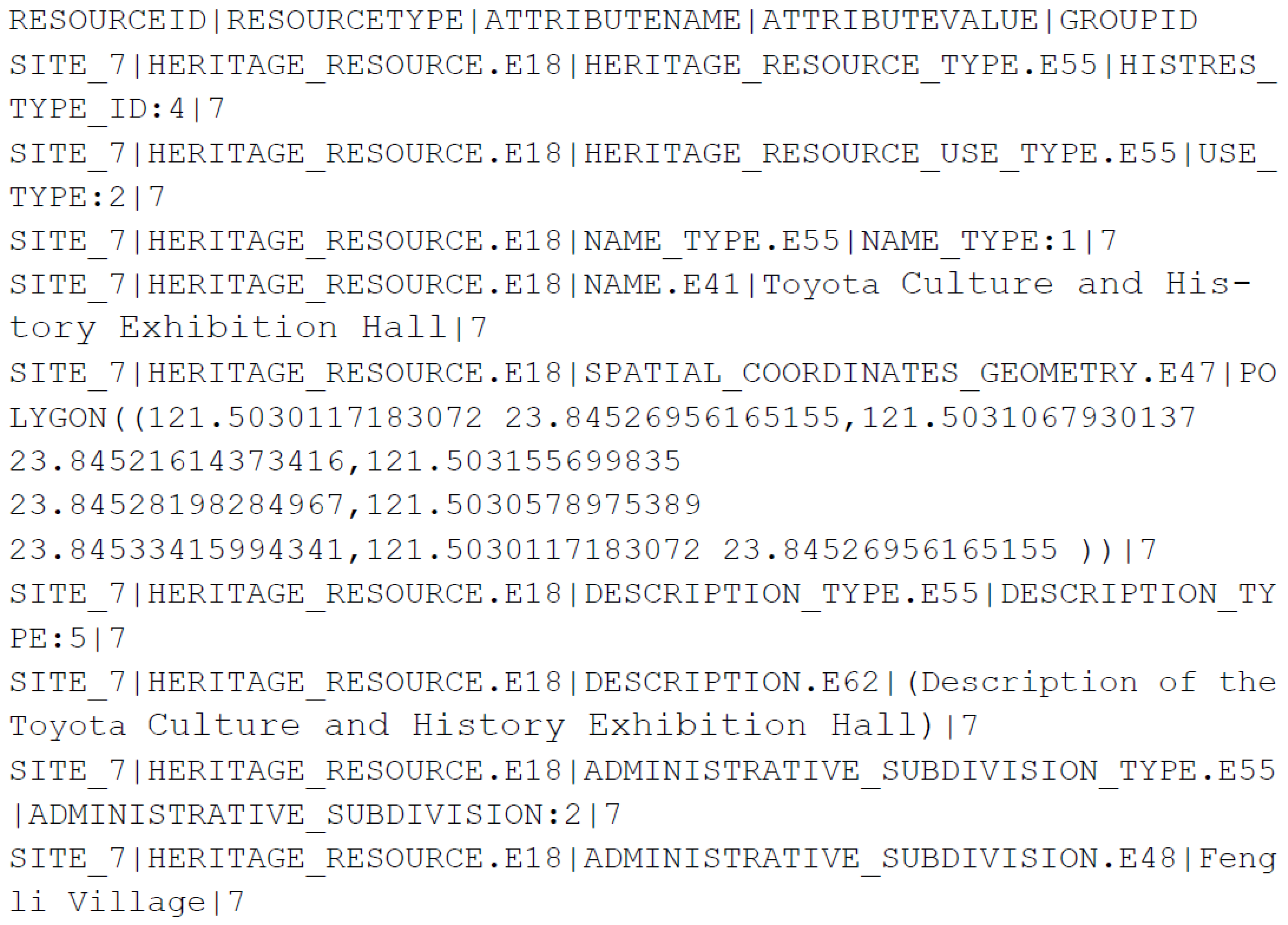
To define domain values that are suitable for describing heritage resources of this research, we created authority files by following the format of authority files that came with Arches-HIP (Table 1, Table 2 and Table 3). Before loading data into the Arches-HIP, we need to prepare two text files with the same name but different suffixes: an “.arches” file and a “.relations” file. The former contains the content of heritage data, and the latter defines the relationships among various resources. For example, we may relate many resources to one resource district, or many actors to a historical event. The “.arches” file contains attribute data of each heritage resource, which include RESOURCEID, RESOURCETYPE, ATTRIBUTENAME, ATTRIBUTEVALUE, and GROUPID. For example, the “Toyota Culture and History Exhibition Hall” (with RESOURCEID of SITE_7) in Nouli Community has several entries in the “.arches” file as shown in Figure 7. These entries are used to specifically describe the heritage resource, including “heritage resource type”, “heritage resource use type”, “name type”, “name”, “spatial coordinates of geometry”, “description type”, “description”, “administrative subdivision type”, and “administrative subdivision”.
As shown in the “.arches” file, both attributes data and geometry of a heritage resource can be defined in it. The geometry must be defined by values using WKT (well-known text) with coordinates set to EPSG (European Petroleum Survey Group) 4326 or latitude/longitude WGS84 [50]. WKT is a standard format for representing vector geometry objects on a map in human-readable text [51]. Moreover, the “.relations” file contains entries that define relationships among heritage resources. For example, the relationships between “Toyota Culture and History Exhibition Hall” and the other heritage resources in Nouli Community are defined as shown in Figure 8. The entries in the file relate this particular heritage resource to “historic district”, “ethnic group”, and several “image objects”. One important thing worth noting is that the only valid values for ATTRIBUTENAME in the “.arches” file are entity types from the resource graph nodes file indicated in the RESOURCETYPE column. The resource graphs and nodes are listed in the online documentation of Arches-HIP (http://arches-hip.readthedocs.org/en/stable/appendix/).
From these spreadsheets, the heritage resources inventory data were converted to relational tables of PosgreSQL database, which were then used to create geospatial database of heritage resources in subsequent steps. To attain a more efficient data processing procedure, we designed Python scripts to extract data from PostgreSQL database and created “arches” files by following the format shown in Figure 7 and Figure 8. Once we have created the “.arches” files and “.relations” for the heritage resources, we can load data into the Arches-HIP database using tools provided by Arches-HIP [34].
3.2. Arches Web Applications
Although the Arches-HIP can be installed on a variety of different platforms, the deployment of Arches-HIP for this research was under the Ubuntu Linux 14.04 LTS environment. The system setup in this research followed the installation procedures described in the online documentation of Arches and Arches-HIP. After completion of the installation process, the system contains a PostgreSQL database with a series of attribute tables that are ready for use. Built with many OSS tools, Arches-HIP provides powerful management tools out of the box for heritage resource managers. The overall architecture of the entire system is shown in Figure 9 [34,35,42].
The Arches-HIP provides ease of use web-based interface for managing heritage resources data. For example, with Resource Data Manager (Figure 10), the resource manager can do the following tasks on historic resources:
- Maintaining resource data: to update descriptions, location, classifications, components, measurements, condition assessment, images and files, related resources, and external system references of the resource.
- Evaluating Resource: to update the designation and evaluation criteria for the resource.
- Managing Resource: to review the edit history of the resource or delete the resource.
All the data about a heritage resource can be viewed and updated by using Resource Data Manager, including modifying the geometry of a resource whether it is a point or a polygon feature. As shown in Figure 10, the resource manager can choose from six types of heritage resources, and the elements associated with the selected resource type will be available for editing. Table 5 shows the resource types and associated elements for each type.
With coordinates information filled, the location of heritage resource can be overlaid on a variety of basemaps, including streets map, satellite images, and a combination of both maps and images. Moreover, additional map layers can be added to the map view, for example Figure 11 shows the heritage resources on a 1:200,000 historic map produced by Japanese in 1897.
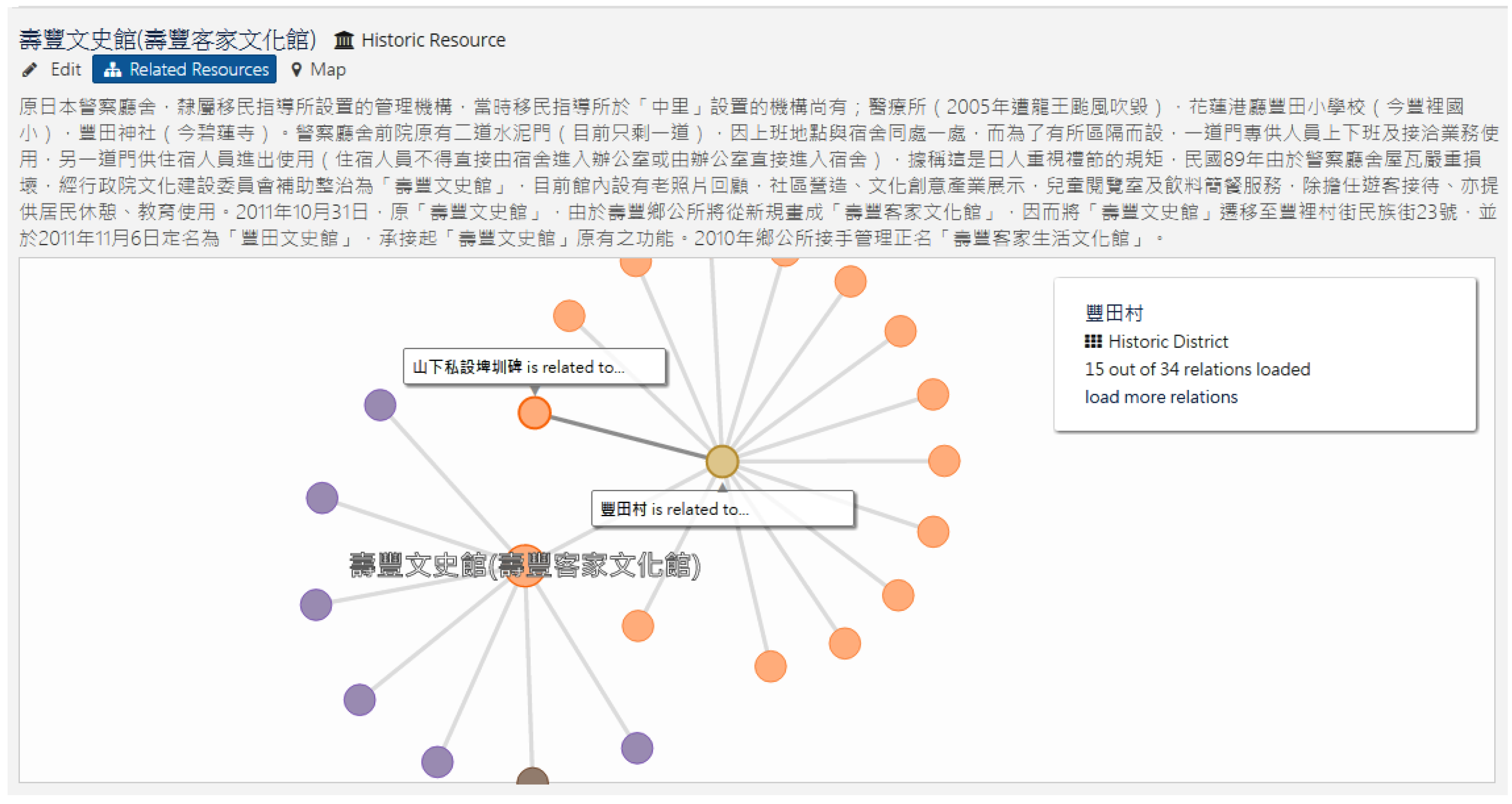
The search function allows users to query database using keywords, and then the Elasticsearch running in the background will perform a full-text search in all fields from all tables of the database. Location filter and time filter can also be used to alter selection if the related information is available. In addition to the location and description, Arches-HIP enables users to check the other related resources and show their relationships by using a dynamic graph. Figure 12 shows the search result of Culture and History Exhibition Hall at Shoufeng Township, and the relationships of this particular heritage resource with the other heritage resources, such as image files, district names, and ethnic information.
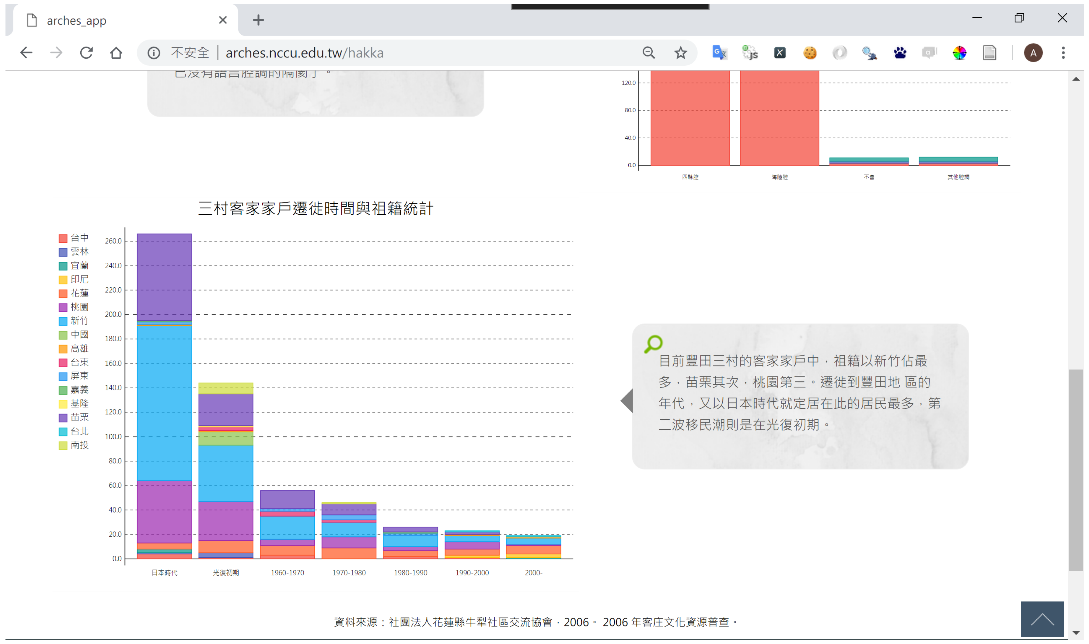
Arches-HIP is built on top of Django, which has many powerful features for rapid development of web-based applications and can be easily customized to meet individual needs. In addition to the functionalities offered by Arches-HIP, we can also use Django as a full-featured web CMS, and create applications that can be integrated with the system. The majority of the people within the community are of Hakka ethnic group, therefore, the cultural characteristics of Hakka are prominent in various aspects. Based on open data downloaded from government agencies and statistics provided by NCDA, we used pygal to generate dynamic statistical charts in SVG format for some web pages. Figure 13 depicts the immigration of Hakka people to the Nouli Community spanning a period of more than a century. More dynamic statistical charts derived from the census of Hakka cultural resources can be found at the website.
4. Discussion
Tang and Tang [52] presented a comparative study on conservation practices of two indigenous communities in Taiwan, which are located in an isolated island, and a mountainous tribal village, respectively. The research results indicate that traditional institutional support on conservation of local resources may collapse as a result of external influences. In contrast, active involvement from local people is an important factor for adapting traditional institutions to confront the challenges from the outside world while preserving natural resources within a local community.
Aiming to establish collaborative relationships between local communities and the government on conservation of natural and cultural resources, the Taiwan Forestry Bureau (TFB) started “Community Forestry Initiative” in 2002. Since then TFB had sponsored more than 1000 projects proposed by hundreds of communities dispersed in rural areas, coastal villages, mountainous settlements, and aboriginal tribes. Most of these community forestry projects focused on developing ecotourism programs that were meant to preserve significant natural and cultural values of the communities while trying to improve economic income of the local residents. Among these communities, Nouli Community is one of the most prominent case that demonstrates the importance of local involvement in cultural and natural conservation [37].
Attempting to develop a system that can be used by many community associations in Taiwan, this research established a community-oriented heritage resources inventory and management system using open-source geospatial software, particularly the Arches-HIP application. Based on the implementation results of this current study, some notable advantages of using the Arches framework to develop a WebGIS (web-based GIS) are described as follows.
To encourage local community to participate in cultural heritage conservation, through Arches-HIP we use the website to provide heritage information to the public, including descriptions of each heritage resource, photographs, panorama, 360-degree videos, and various types of data. The Arches-HIP system implements internationally adopted standards (CIDOC Conceptual Reference Model) for heritage data definition and management, which is essential for data sharing and international collaboration on heritage conservation. Following these standards not only assure data integrity, but also are beneficial to customize or extend the system to meet different needs.
The Arches-HIP provides an array of powerful tools for heritage resources inventory and management. To fully use its functionalities, however, the resource manager must plan the implementation with caution, especially preparing authority files with proper controlled vocabularies is an important step for creating the database. Well-organized authority files can ensure data consistency and facilitate maintaining high quality of the database.
The Arches-HIP supports geospatial technology standards, such as OGC standards on spatial data and web services. This is very important to develop a system that can be interoperable both on retrieving images and maps from the other servers, and publishing heritage data as standard web service that may be consumed by the other GIS applications. For example, we are able to add historic map layers and satellite imageries to the map view, which are very helpful to understand the landscape and historic changes of the study site.
The fact that Arches-HIP supports web application standards is also very important for building a cross-platform system. Unlike some web-based applications that require special browsers and plugins to work on the system, the heritage inventory and management system established in this research works well on different platforms and web browsers. The desktop platforms we have tested include Mac OS, Linux, and Microsoft Windows 7/8/10, using modern web browsers such as Chrome, Firefox, Safari, Internet Explorer, and Edge. The Bootstrap framework is adopted by Arches for responsive website development with CSS styles that can easily adjust to desktops, tablets, and mobiles. For mobile and smart devices running Apple iOS and Google Android, the embedded browser can automatically fit the web page to the screen, whether it is a smart phone, or a tablet computer. This feature is very helpful for field investigation and promoting tourism program of the community.
Although Arches-HIP provides user-friendly management tools for maintaining the database, it is still a challenge for the researcher to enter resource data into the database if the data volume is large. Arches-HIP provides a convenient tool for importing shapefile to the database, including attribute data and geometries of features. However, if the relationships among heritage resources are more complicated, loading data into the database by using text file in “arches” format is more preferable [34]. Based on our experience, we find that spreadsheet software is an effective tool for inputting field data because of its availability and ease of use. We used spreadsheets to store raw data, and in some instances, we used them to communicate with local participants for data validation. Once the data is ready for entering to the Arches-HIP database, the Python scripts developed for this study allow us to import field data to the database in a more efficient and effective way.
Unlike some implementations of heritage management system that seem to be successful but do not provide required software and documentation, Arches-HIP is an integrated OSS platform specifically built for heritage field. The official release of the system provides source codes, detailed documentation, and sample data, which are very helpful for understanding how CIDOC-CRM can be implemented for heritage resources inventory and management. Arches-HIP comprises many OSS tools. Therefore, it can be implemented for different communities or countries with low cost if the application developer has appropriate software skills. Arches-HIP depends on several OSS software tools with certain versions. This software may need to be updated for enhancement or security problems; however, we had experienced some problems due to software dependency issues if we installed newer versions of these required software. As a result, we had to install the software in an isolated Python environment [53] such that multiple versions could coexist without interfering each other. For future development, we suggest that the software should be packaged using Docker container technology [54] because it works much better especially if non-Python software are required. Although Arches 4.0 had been released, it does not provide software package such as HIP, which we think can be useful for future implementations.
5. Conclusions
Community involvement has been proven to be an important element for strategical planning and practice of cultural and ecological conservation. In this research, the researcher collaborated with NCDA in collecting heritage resources data and creating a heritage resources inventory and management system. The results of this study show that, using open-source geospatial software, we were able to build the system with very low cost. Moreover, the implementation is scalable, and can be easily adapted to different communities without needing to purchase expensive proprietary software. This can be very helpful to develop applications for a wide array of local communities and indigenous people and encourage public participation in heritage conservation.
Funding
This research received no external funding. The research was supported by grants from the National Science Council of Taiwan (NSC 102-2621-M-004-008-MY3).
Acknowledgments
The author is grateful to the Nouli Community Development Association for sharing their data with us, and the research team for field data collection and manipulation, particularly Wan-Hsin Mao for her help in implementing the Arches-HIP application. The author also would like to thank GCI and many developers of the OSS that were used in this research.
Conflicts of Interest
The author declares no conflict of interest.
References
- Rössler, M. Partners in site management. A shift in focus: Heritage and community involvement. In Community Development through World Heritage; Albert, M.T., Richon, M., Vnals, M.J., Witcomb, A., Eds.; UNESCO: Paris, France, 2012; pp. 27–31. ISBN 978-92-3-001024-9. [Google Scholar]
- Chirikure, S.; Pwiti, G. Community involvement in archaeology and cultural heritage management: An assessment from case studies in Southern Africa and elsewhere. Curr. Anthropol. 2008, 49, 467–485. [Google Scholar] [CrossRef]
- Mawere, M.; Sagiya, M.E.; Mubaya, T.R. Conservation conversations and community participation in the management of heritage sites in Zimbabwe. Greener J. Environ. Manag. Public Saf. 2012, 2, 7–16. [Google Scholar]
- Bushozi, P.M. Towards sustainable cultural heritage management in Tanzania: A case study of Kalenga and Mlambalasi sites in Iringa, Southern Tanzania. S. Afr. Archaeol. Bull. 2014, 69, 136–141. [Google Scholar]
- Mudge, M.; Ashley, M.; Schroer, C. A Digital Future for Cultural Heritage. Int. Arch. Photogram. Remote Sens. Spat Inf. Sci. 2007, 36–5/C53. Available online: http://www.isprs.org/proceedings/XXXVI/5-C53/papers/FP104.pdf (accessed on 29 October 2018).
- Santana Quintero, M.; Georgopoulos, A.; Stylianidis, E.; Lerma, J.L.; Remondino, F. CIPA’s Mission: Digitally Documenting Cultural Heritage. APT Bull. J. Preserv. Technol. 2017, 48, 51–54. [Google Scholar]
- Crofts, N.; Doerr, M.; Gill, T.; Stead, S.; Stiff, M. Definition of the CIDOC Conceptual Reference Model; ICOM/CIDOC CRM Special Interest Group; ICOM Deutschland: Berlin, Germany, 2011. [Google Scholar]
- Steiniger, S.; Bocher, E. An overview on current free and open source desktop GIS developments. Int. J. Geogr. Inf. Sci. 2009, 23, 1345–1370. [Google Scholar] [CrossRef]
- Steiniger, S.; Hunter, A.J. Free and open source GIS software for building a spatial data infrastructure. In Geospatial Free and Open Source Software in the 21st Century. Lecture Notes in Geoinformation and Cartography; Bocher, E., Neteler, M., Eds.; Springer: Berlin/Heidelberg, Germany, 2012; pp. 247–261. ISBN 978-3-642-10594-4. [Google Scholar]
- Brovelli, M.A.; Minghini, M.; Moreno-Sanchez, R.; Oliveira, R. Free and open source software for geospatial applications (FOSS4G) to support Future Earth. Int. J. Digit. Earth 2016, 10, 386–404. [Google Scholar] [CrossRef]
- Gkoumas, G.; Lazarinis, F. Preserving Cultural Heritage Using Open Source Collection Management Tools. Dig. Present. Preserv. Cult. Sci. Herit. 2013, 3, 169–175. [Google Scholar]
- Open Video Digital Library Toolkit. Available online: https://github.com/ovdlt/open-video-digital-library-toolkit (accessed on 10 September 2018).
- Marchionini, G.; Geisler, G. The Open Video Digital Library. D-Lib Mag. 2002, 8, 12. [Google Scholar] [CrossRef]
- CollectionSpace. Available online: http://www.collectionspace.org (accessed on 10 September 2018).
- The Open Video Project: A Shared Digital Video Collection. Available online: https://open-video.org/index.php (accessed on 10 September 2018).
- Meyer, E.; Grussenmeyer, P.; Perrin, J.P.; Durand, A.; Drap, P. A web information system for the management and the dissemination of Cultural Heritage data. J. Cult. Herit. 2007, 8, 396–411. [Google Scholar] [CrossRef] [Green Version]
- Vacca, G.; Fiorino, D.R.; Pili, D. A WebGIS for the knowledge and conservation of the historical buildings in Sardinia (Italy). Int. Arch. Photogram. Remote Sens. Spat. Inf. Sci. 2017. [Google Scholar] [CrossRef]
- Vacca, G.; Fiorino, D.R.; Pili, D. A spatial information system (SIS) for the architectural and cultural heritage of Sardinia (Italy). ISPRS Int. J. Ceo-Inf. 2018, 7, 49. [Google Scholar] [CrossRef]
- Petrescu, F. The Use of GIS Technology in Cultural Heritage. Int. Arch. Photogram. Remote Sens. Spat. Inf. Sci. 2007, XXXVI–5/C53. Available online: http://www.isprs.org/proceedings/XXXVI/5-C53/papers/FP114.pdf (accessed on 29 October 2018).
- Smuts, K.; Mlungwana, N.; Wiltshire, N. SAHRIS: South Africa’s integrated, web-based heritage management system. J. Cult. Herit. Manag. Sustain. Dev. 2016, 6, 38–152. [Google Scholar] [CrossRef]
- South African Heritage Resources Agency. South African Heritage Resources Information System (SAHRIS). Available online: https://www.sahra.org.za/sahris/about/sahris (accessed on 10 September 2018).
- Paul Getty Trust and World Monuments Fund. Arches: Fact Sheet, Standards & Interoperability, Project Background, Implementations of Arches, and Downloads. Available online: http://www.archesproject.org (accessed on 10 September 2018).
- Carlisle, P.K.; Avramides, I.; Dalgity, A.; Myers, D. The Arches Heritage Inventory and Management System: A Standards-Based Approach to the Management of Cultural Heritage Information. In Proceedings of the CIDOC (International Committee for Documentation of the International Council of Museums) Conference Access and Understanding—Networking in the Digital Era, Dresden, Germany, 6–11 September 2014. [Google Scholar]
- Myers, D.; Dalgity, A.; Avramides, I.; Wuthrich, D. Arches: An open source GIS for the inventory and management of immovable cultural heritage. In Progress in Cultural Heritage Preservation. EuroMed 2012. Lecture Notes in Computer Science; Ioannides, M., Fritsch, D., Leissner, J., Davies, R., Remondino, F., Caffo, R., Eds.; Springer: Berlin/Heidelberg, Germany, 2012; Volume 7616, pp. 817–824. [Google Scholar]
- Wiltshire, N.G. The use of SAHRIS as a state sponsored digital heritage repository and management system in South Africa. Int. Ann. Photogram. Remote Sens. Spat. Inf. Sci. 2013, II–5/W1, 325–330. [Google Scholar] [CrossRef]
- Mlungwana, N. Using SAHRIS a web-based application for creating heritage cases and permit applications. Int. Arch. Photogram. Remote Sens. Spat. Inf. Sci. 2015, XL–5/W7, 337–341. [Google Scholar] [CrossRef]
- Smuts, K. SAHRIS: Using the South African Heritage Register to report, track and monitor heritage crime. Int. Arch. Photogram. Remote Sens. Spat. Inf. Sci. 2015, XL–5/W7, 395–402. [Google Scholar] [CrossRef]
- Drupal. Documentation. Available online: https://www.drupal.org/docs/user_guide/en/understanding-drupal.html (accessed on 10 September 2018).
- Django. Overview of Django. Available online: https://www.djangoproject.com/start/overview/ (accessed on 10 September 2018).
- Barton, C.; Cox, A.; Cruz, S.D.; Hansen, J. Cultural-heritage inventory implementations: The versatility of the Arches system. APT Bull. J. Preserv. Technol. 2017, 48, 19–28. [Google Scholar]
- International Core Data Standard for Archaeological Sites and Monuments. In Documenting the Cultural Heritage; Thornes, R.; Bold, J. (Eds.) The Getty Information Institute: Los Angeles, CA, USA, 1998. [Google Scholar]
- The Getty Conservation Institute and World Monuments Fund. MEGA-Jordan: The National Heritage Documentation and Management System. Available online: http://megajordan.org/ (accessed on 10 September 2018).
- Myers, D.; Dalgity, A. The Middle Eastern Geodatabase for Antiquities (MEGA): An Open Source GIS-Based Heritage Site Inventory and Management System. Available online: http://www.getty.edu/conservation/our_projects/field_projects/jordan/mega_jordan_cot_article.pdf (accessed on 10 September 2018).
- Arches-HIP Documentation. Available online: https://arches-hip.readthedocs.io/ (accessed on 10 September 2018).
- Arches Documentation v3.1.2. Available online: https://arches.readthedocs.io/en/3.1.2/ (accessed on 10 September 2018).
- Arches Project: Customization of Arches for City of Los Angeles. Available online: http://www.getty.edu/conservation/our_projects/field_projects/arches/arches_city_la.html (accessed on 10 September 2018).
- Nouli Community Association. Available online: http://www.nlica.org.tw/ (accessed on 10 September 2018).
- Pygal. Available online: http://www.pygal.org/en/latest/ (accessed on 10 September 2018).
- GEOS—Geometry Engine, Open Sources. Available online: http://trac.osgeo.org/geos (accessed on 10 September 2018).
- Chen, L.K.; Inoue, H.; Won, C.W.; Lin, C.H.; Lin, K.F.; Tsay, S.F.; Lin, P.F.; Li, S.H. Challenges of urban aging in Taiwan: Summary of urban aging forum. J. Clin. Gerontol. Geriat. 2013, 4, 97–101. [Google Scholar] [CrossRef]
- Jan, J.F. Digital heritage inventory using open source geospatial software. In Proceedings of the 22nd International Conference on Virtual Systems & Multimedia (VSMM), Kuala Lumpur, Malaysia, 17–21 October 2016. [Google Scholar]
- Mao, W.H. Application of Open Source GIS in Digital Conservation of Heritage: A Case Study of Arches. Master’s Thesis, National Chengchi University, Taipei, Taiwan, 2016. [Google Scholar]
- Nouli Community Association (Built with Arches). Available online: http://arches.nccu.edu.tw/ (accessed on 10 September 2018).
- The LizardQ Stitcher. Available online: https://www.lizardq.com/en/features-software/ (accessed on 10 September 2018).
- LizardQ User Manual. Available online: https://www.lizardq.com/cdn/docs/LizardQUserManual.pdf (accessed on 10 September 2018).
- GNU Image Manipulation Program (GIMP). Available online: https://www.gimp.org/ (accessed on 10 September 2018).
- Spatial Media Metadata Injector. Available online: https://github.com/google/spatial-media/blob/master/spatialmedia/README.md (accessed on 10 September 2018).
- YouTube Help. Upload 360-Degree Videos. Available online: https://support.google.com/youtube/answer/6178631?hl=en (accessed on 10 September 2018).
- Keyhole Markup Language. KML Tutorial. Available online: https://developers.google.com/kml/documentation/kml_tut (accessed on 10 September 2018).
- EPSG (European Petroleum Survey Group):4326. Available online: http://spatialreference.org/ref/epsg/4326/ (accessed on 10 September 2018).
- Wikipedia. Well-Known Text. Available online: https://en.wikipedia.org/wiki/Well-known_text (accessed on 10 September 2018).
- Tang, C.P.; Tang, S.Y. Institutional Adaptation and Community-Based Conservation of Natural Resources: The Cases of the Tao and Atayal in Taiwan. Hum. Ecol. 2010, 38, 101–111. [Google Scholar] [CrossRef]
- Virtualenv. Available online: https://virtualenv.pypa.io/en/stable/ (accessed on 10 September 2018).
- Docker. Available online: https://www.docker.com/ (accessed on 10 September 2018).
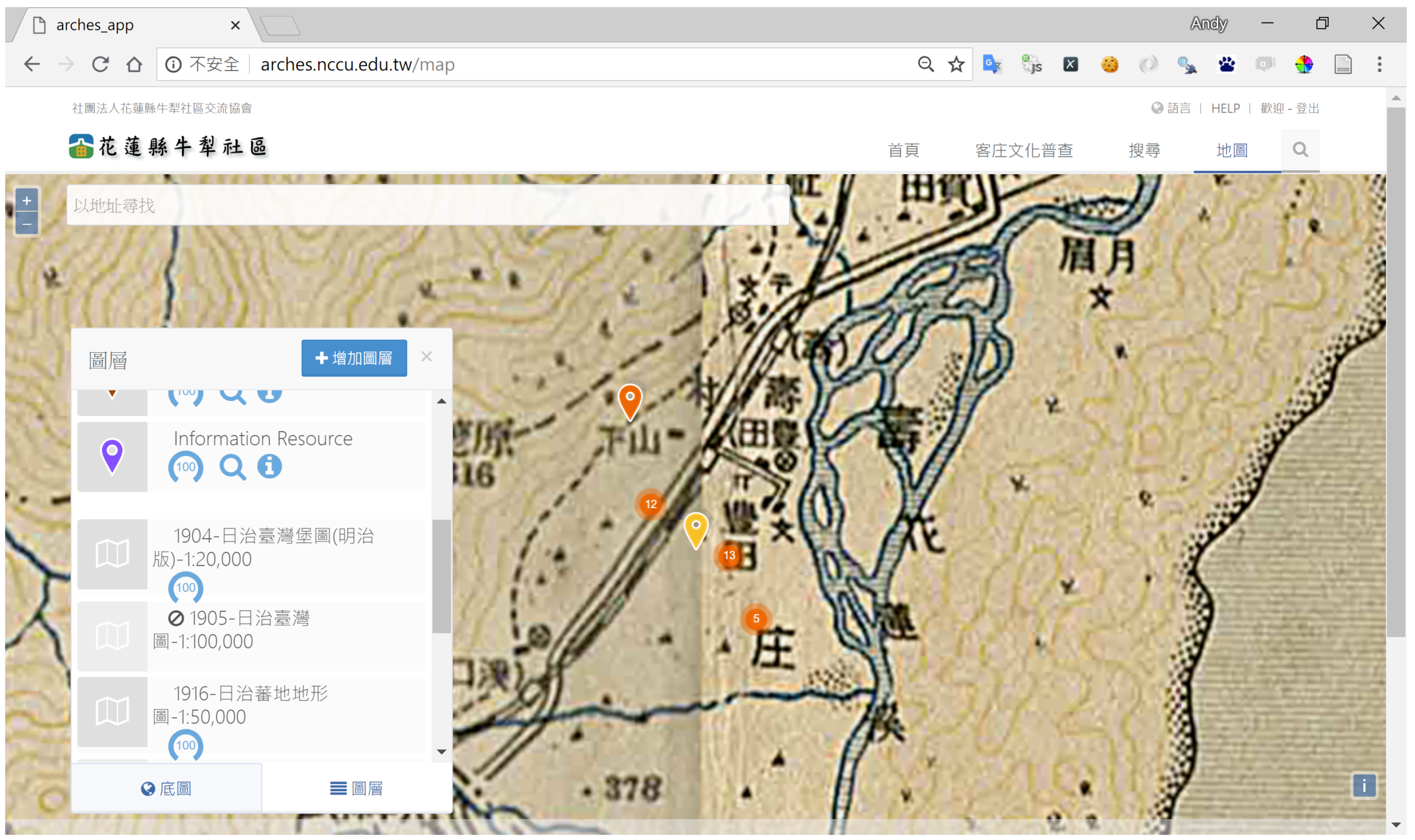
Figure 1.
The MAP VIEW of Nouli Community Arches platform showing locations of heritage sites on Bing Maps.
Figure 1.
The MAP VIEW of Nouli Community Arches platform showing locations of heritage sites on Bing Maps.

Figure 2.
The study site of this research. The overview image of Taiwan is from Google Earth, and the base map is from a WMS server created by the National Land Surveying and Mapping Center, Ministry of the Interior, Taiwan.
Figure 2.
The study site of this research. The overview image of Taiwan is from Google Earth, and the base map is from a WMS server created by the National Land Surveying and Mapping Center, Ministry of the Interior, Taiwan.
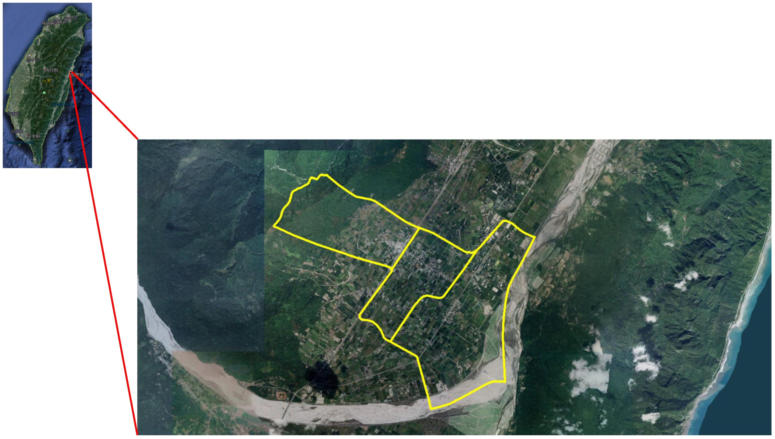
Figure 3.
Panoramic image of the of Hakka Culture Exhibition Center, which was obtained by using LizardQ camera system. The image is on Google Cloud so that viewers can observe the scene from every viewing angle. https://bit.ly/2PYxE7U.
Figure 3.
Panoramic image of the of Hakka Culture Exhibition Center, which was obtained by using LizardQ camera system. The image is on Google Cloud so that viewers can observe the scene from every viewing angle. https://bit.ly/2PYxE7U.

Figure 4.
A screen capture of a 360 video derived from panorama of the Hakka Culture Exhibition Center viewed in YouTube app. The video is on YouTube so that viewers can use VR headset to experience immersive virtual reality without the need to visit the site. https://youtu.be/x4PnMW1FG9U.
Figure 4.
A screen capture of a 360 video derived from panorama of the Hakka Culture Exhibition Center viewed in YouTube app. The video is on YouTube so that viewers can use VR headset to experience immersive virtual reality without the need to visit the site. https://youtu.be/x4PnMW1FG9U.
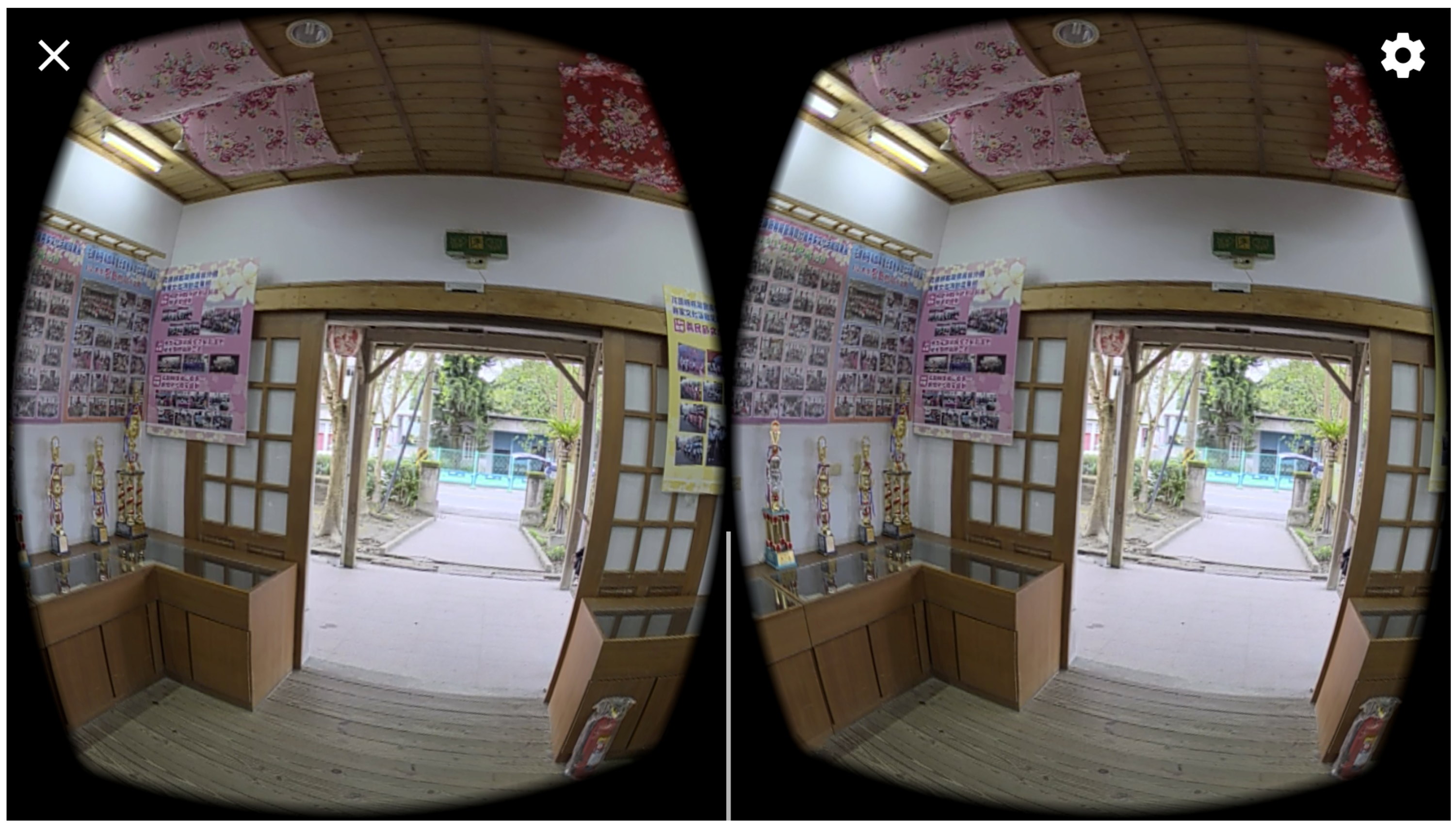
Figure 5.
Definition of a placemark in a KML file.

Figure 6.
Microsoft Excel spreadsheets were used to enter heritage resource data, including site IDs, names, geometries, town IDs, and description.
Figure 6.
Microsoft Excel spreadsheets were used to enter heritage resource data, including site IDs, names, geometries, town IDs, and description.
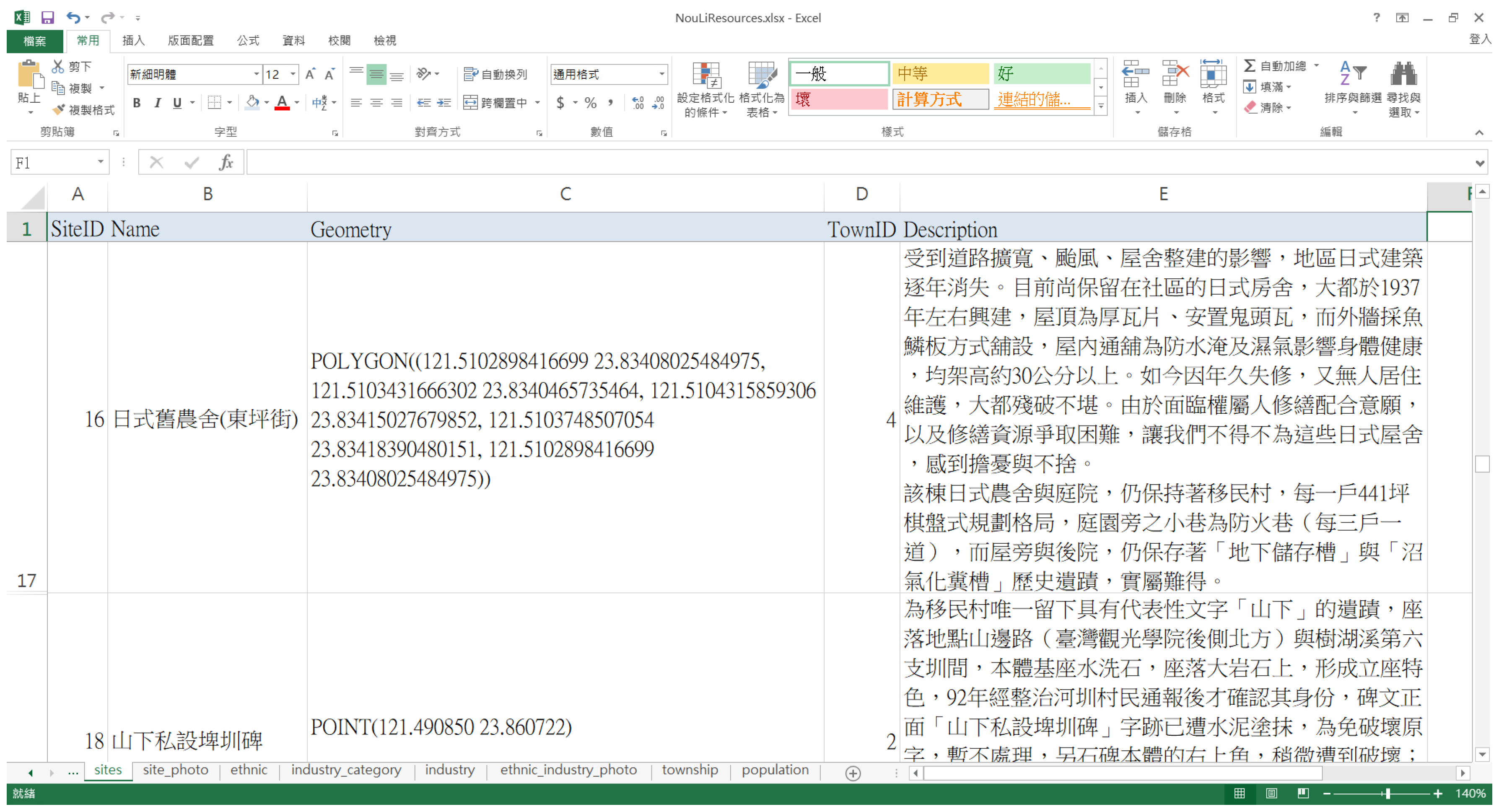
Figure 7.
An example of “.arches” file, which contains attributes and geometry of the “Toyota Culture and History Exhibition Hall”.
Figure 7.
An example of “.arches” file, which contains attributes and geometry of the “Toyota Culture and History Exhibition Hall”.

Figure 8.
An example of “.relations” file, which defines relationships among heritage resources.

Figure 9.
The overall architecture of the Arches heritage management system.
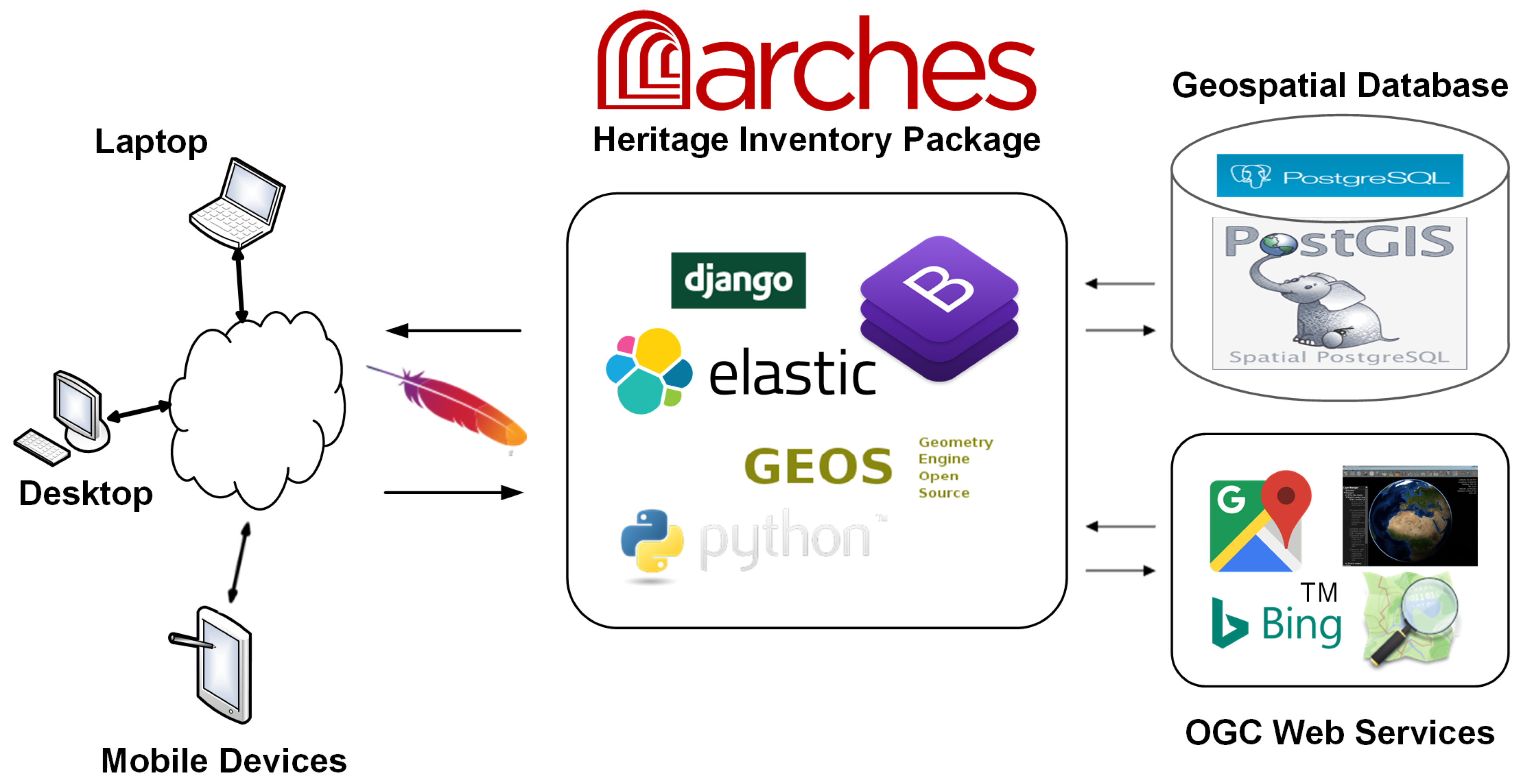
Figure 10.
The Resource Data Manager of Arches-HIP.
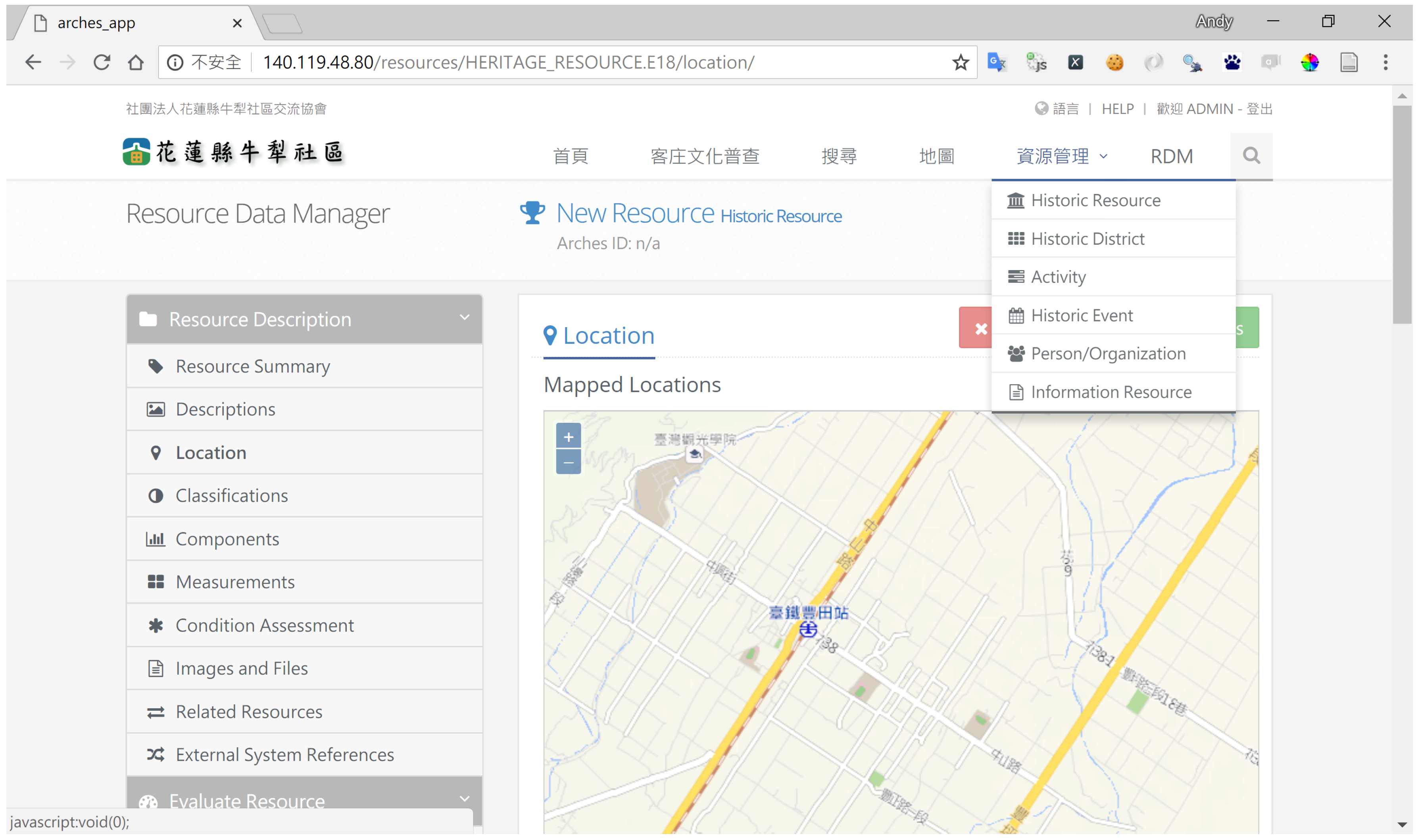
Figure 11.
Heritage resources overlaid on historic map produced in 1897.

Figure 12.
The detail information of a heritage resource and the relation graph.

Figure 13.
The website uses scalable vector graphics (SVG) to show dynamic statistical chart for open data downloaded from government agencies. This figure depicts the immigration of Hakka people to the Nouli Community spanning a period of more than a century. http://arches.nccu.edu.tw/hakka.
Figure 13.
The website uses scalable vector graphics (SVG) to show dynamic statistical chart for open data downloaded from government agencies. This figure depicts the immigration of Hakka people to the Nouli Community spanning a period of more than a century. http://arches.nccu.edu.tw/hakka.


Table 1.
A partial list of authority files included in Arches-HIP, which contain controlled vocabularies.
Table 1.
A partial list of authority files included in Arches-HIP, which contain controlled vocabularies.
| Entity Type | Authority Document |
|---|---|
| CONDITION_TYPE.E55 | CONDITION_AUTHORITY_DOCUMENT.csv |
| CULTURAL_PERIOD.E55 | CULTURAL_PERIOD_AUTHORITY_DOCUMENT.csv |
| DISTURBANCE_TYPE.E55 | DISTURBANCE_TYPE_AUTHORITY_DOCUMENT.csv |
| LANGUAGE.E55 | LANGUAGE_AUTHORITY_DOCUMENT.csv |
| MATERIAL.E57 | MATERIAL_AUTHORITY_DOCUMENT.csv |
| MEASUREMENT_TYPE.E55 | MEASUREMENT_TYPE_AUTHORITY_DOCUMENT.csv |
| MODIFICATION_TYPE.E55 | MODIFICATION_TYPE_AUTHORITY_DOCUMENT.csv |
| NAME_TYPE.E55 | NAME_TYPE_AUTHORITY_DOCUMENT.csv |
| SETTING_TYPE.E55 | SETTING_TYPE_AUTHORITY_DOCUMENT.csv |
| STYLE.E55 | STYLE_AUTHORITY_DOCUMENT.csv |
| STATUS.E55 | STATUS_AUTHORITY_DOCUMENT.csv |
| THREAT_TYPE.E55 | THREAT_TYPE_AUTHORITY_DOCUMENT.csv |
Table 2.
A list of values for conditions defined in “CONDITION_AUTHORITY_DOCUMENT.csv”.
| Conceptid | PrefLabel | AltLabels | Parent Conceptid | Concept Type | Provider |
|---|---|---|---|---|---|
| CONDITION | 1 | good | CONDITION_AUTHORITY_DOCUMENT.csv | Index | GCI |
| CONDITION | 2 | fair | CONDITION_AUTHORITY_DOCUMENT.csv | Index | GCI |
| CONDITION | 3 | poor | CONDITION_AUTHORITY_DOCUMENT.csv | Index | GCI |
| CONDITION | 4 | very bad | CONDITION_AUTHORITY_DOCUMENT.csv | Index | GCI |
Table 3.
The “MEASUREMENT_TYPE_AUTHORITY_DOCUMENT.csv” contains a list of values for measurement types.
Table 3.
The “MEASUREMENT_TYPE_AUTHORITY_DOCUMENT.csv” contains a list of values for measurement types.
| Conceptid | PrefLabel | AltLabels | Parent Conceptid | Concept Type | Provider |
|---|---|---|---|---|---|
| MEASUREMENT_TYPE | 1 | length | MEASUREMENT_TYPE_AUTHORITY_DOCUMENT.csv | Index | EH |
| MEASUREMENT_TYPE | 2 | depth | MEASUREMENT_TYPE_AUTHORITY_DOCUMENT.csv | Index | EH |
| MEASUREMENT_TYPE | 3 | breadth | MEASUREMENT_TYPE_AUTHORITY_DOCUMENT.csv | Index | EH |
| MEASUREMENT_TYPE | 4 | weight | MEASUREMENT_TYPE_AUTHORITY_DOCUMENT.csv | Index | EH |
| MEASUREMENT_TYPE | 5 | tonnage | MEASUREMENT_TYPE_AUTHORITY_DOCUMENT.csv | Index | EH |
| MEASUREMENT_TYPE | 6 | height | MEASUREMENT_TYPE_AUTHORITY_DOCUMENT.csv | Index | EH |
Table 4.
Software used in this research.
| Name of Software | Version | Purpose |
|---|---|---|
| Ubuntu Server | 14.04 LTS | The platform used for software installation and development. |
| Apache | 2.4.7 | The web server software. |
| Python | 2.7.6 | Used for developing data processing scripts. |
| Django | 1.6.2 | A web development framework written in Python. |
| Bootstrap | 3.3.5 | An open-source toolkit for developing responsive websites. |
| Elasticsearch | 1.4.1 | Library for providing full-text searching. |
| PostgreSQL | 9.3 | The relational database management system. |
| PostGIS | 2.2.0 | Supports spatial database extension for PostgreSQL. |
| GEOS | 3.4.2 | The most popular geospatial library that is used by PostGIS. |
| pygal | 2.1.1 | A Python library for creating statistical charts in SVG format. |
Table 5.
Resource types and associated elements for editing in Resource Data Manager of Arches-HIP.
| Resource Type | Associated Elements |
|---|---|
| Historic Resource | Resource Summary, Descriptions, Location, Classifications, |
| Components, Measurements, Condition Assessment, Images and Files, | |
| Related Resources, External System References, Designation, Evaluation Criteria | |
| Historic District | Resource Summary, Descriptions, Location, Classifications, |
| Measurements, Condition Assessment, Evaluation Criteria, | |
| Designation, Related Resources, and External System References | |
| Activity | Resource Summary, Descriptions, Location, Actions, |
| Related Resources, and External System References | |
| Historic Event | Resource Summary, Descriptions, Location, Phase, |
| Related Resources, and External System References | |
| Person/Organization | Actor Summary, Descriptions, Location, Role, |
| Related Resources, and External System References | |
| Information Resource | Resource Summary, Creation and Publication, Coverage, |
| Descriptions, File Upload, Related Resources, and External System References |
© 2018 by the author. Licensee MDPI, Basel, Switzerland. This article is an open access article distributed under the terms and conditions of the Creative Commons Attribution (CC BY) license (http://creativecommons.org/licenses/by/4.0/).
Share and Cite
MDPI and ACS Style
Jan, J.-F. Application of Open-Source Software in Community Heritage Resources Management. ISPRS Int. J. Geo-Inf. 2018, 7, 426. https://0-doi-org.brum.beds.ac.uk/10.3390/ijgi7110426
AMA Style
Jan J-F. Application of Open-Source Software in Community Heritage Resources Management. ISPRS International Journal of Geo-Information. 2018; 7(11):426. https://0-doi-org.brum.beds.ac.uk/10.3390/ijgi7110426
Chicago/Turabian StyleJan, Jihn-Fa. 2018. "Application of Open-Source Software in Community Heritage Resources Management" ISPRS International Journal of Geo-Information 7, no. 11: 426. https://0-doi-org.brum.beds.ac.uk/10.3390/ijgi7110426
Note that from the first issue of 2016, this journal uses article numbers instead of page numbers. See further details here.