Revisiting the Role of Place in Geographic Information Science


Department of Geoinformatics—Z_GIS, University of Salzburg, Schillerstraße 30, 5020 Salzburg, Austria
*
Author to whom correspondence should be addressed.
ISPRS Int. J. Geo-Inf. 2018, 7(9), 364; https://0-doi-org.brum.beds.ac.uk/10.3390/ijgi7090364
Submission received: 29 May 2018
/
Revised: 31 August 2018
/
Accepted: 3 September 2018
/
Published: 5 September 2018
(This article belongs to the Special Issue Place-Based Research in GIScience and Geoinformatics)
Abstract
:Although place-based investigations into human phenomena have been widely conducted in the social sciences over the last decades, this notion has only recently transgressed into Geographic Information Science (GIScience). Such a place-based GIS comprises research from computational place modeling on one end of the spectrum, to purely theoretical discussions on the other end. Central to all research that is concerned with place-based GIS is the notion of placing the individual at the center of the investigation, in order to assess human-environment relationships. This requires the formalization of place, which poses a number of challenges. The first challenge is unambiguously defining place, to subsequently be able to translate it into binary code, which computers and geographic information systems can handle. This formalization poses the next challenge, due to the inherent vagueness and subjectivity of human data. The last challenge is ensuring the transferability of results, requiring large samples of subjective data. In this paper, we re-examine the meaning of place in GIScience from a 2018 perspective, determine what is special about place, and how place is handled both in GIScience and in neighboring disciplines. We, therefore, adopt the view that space is a purely geographic notion, reflecting the dimensions of height, depth, and width in which all things occur and move, while place reflects the subjective human perception of segments of space based on context and experience. Our main research questions are whether place is or should be a significant (sub)topic in GIScience, whether it can be adequately addressed and handled with established GIScience methods, and, if not, which other disciplines must be considered to sufficiently account for place-based analyses. Our aim is to conflate findings from a vast and dynamic field in an attempt to position place-based GIS within the broader framework of GIScience.
1. Introduction
Although the concept of place plays a central role in everyday life and in a number of scientific disciplines, such as human spatial cognition and communication, as well as human, economic, and cultural geography, it is only rarely breached in GIScience [1]. This can perhaps be attributed to the difficulty in capturing and modeling place in a formal and unambiguous manner, because of the binary concept on which a computer system, and thus, a GIS is founded [1,2]. Translating the informal world of human discourse into the rigid binary alphabet of zeros and ones requires strict and precise rules [2]. This requirement poses a challenge to researchers, due to the inherent vagueness and subjectivity of the human data produced in the humanities or social sciences. However, successfully implementing a robust place definition in GIS would allow for us to analyze such “soft” data types, offering a scientifically sound insight into the cause and effect relationships between humans and their environment.
According to Davies et al. [3] (p. 175), the main challenges of operationalizing place in GIScience and GIS research is “the lack of precise locations, crisp boundaries and single universal names for many places that people talk about in everyday life”. Based on this argument of place being anchored in “location”, an obvious starting point to tackling the concept of place is to frame it in a spatial context or to utilize space as a proxy indicator for place. However, many argue that space is “rigidly scientific but substantively uninteresting” [2] (p. 15), as it does not play a fundamental role in society. Place, on the other hand, is highly contextual and is plagued by the vagueness of definition, thus hampering its transformation into an unambiguous formalized concept. Goodchild [2] (p. 11) points out that the term “performs a variety of functions in different settings”. These functions depend both on the disciplinary background of the analyst and on the general scale and purpose of the analysis. He argues, for instance, that social scientists are generally interested in analyzing human behavior and human-environment interactions, whereby place serves as a context [2]. In this sense, place is oftentimes simply reduced to the geographic setting, in which said actions take place, for instance, where humans carry out aspects of their daily lives, such as shopping, working, sleeping, and educational or recreational activities [2]. Although reduced to simple geographic space, such places play a pivotal and unique role in an individual’s life and are, thus, generally subject to temporal change along with the individual’s circumstances. However, Kabachnik [4] points out that places are not only subject to temporal change, but in many cases, also to spatial change, thus rendering a spatial definition impractical. Examples of moving places comprise, but are not limited to, cruise ships, motor homes, nomad camps, or shifting administrative borders [4]. It is this decoupling of space and place, the necessity for different “platial” scales, as well as the consideration of the temporal component, which poses a challenge in depicting and analyzing place with GISs.
A GIS works with layers of data from various sources, all of which can be spatially contextualized in a distinct and unambiguous manner using a spatial reference system. This allows for the data to be displayed and analyzed spatially, which means that spatial relationships between features can be examined and spatial phenomena can be mapped. However, analyzing and mapping place, as opposed to space, goes far beyond the typical demands put to a conventional map; it comprises mapping latent phenomena without fiat boundaries, and thus, exceeds the typical GIS-based analyses, which tend to be centred around and limited to “the mappable”. When considering human experience in terms of “where”, “how”, and “why”, especially questions of “why” can rarely be reduced to hard-coded information, and thus analyzed and mapped to a single location.
When considering the notable value of analyzing human-environment interactions and human experience for many research branches, such as urban planning, quality of life studies, human-computer interaction, market research, and so on, the apparent lack of a unified, targeted agenda seems strikingly odd. As pointed out by Goodchild [2] (p. 15), “several conferences over the past few years have drawn attention to the growing interest in spatially detailed analyses of human dynamics. Yet, at this time, there is no single, comprehensive text on the topic, and courses in universities are few and far between. Given time, perhaps a new field will emerge at this intersection between digital technology, social science, and digital data. If it does, the concept of place will clearly occupy a central position”.
In this paper, we seek to determine whether such a field has emerged in the seven years since Goodchild’s observation and to determine the spectrum of approaches in a variety of disciplines following one and the same aim, namely that of formalizing the vague concept of place to better understand human experience. Our main research questions are whether place is or should be a significant (sub)topic in GIScience, whether it can be adequately addressed and handled with established GIScience methods, and, if not, which other disciplines must be considered to sufficiently account for place-based analyses. In a bid to answer these questions, a comprehensive literature review is conducted in GIScience and in the related disciplines. Approaches are outlined and thematically grouped, in order to paint a holistic and comprehensive picture of the research avenue that is place-based GIS. It is important to note that a complete review of all literature relating to place-based GIS is hardly feasible, especially given the number of disciplines and sub-disciplines that would need to be considered. Rather, this research focuses on those place-based approaches, where GIScience serves as the underlying methodology, and not GIS as a tool. The selection criteria for the approaches that were dealing with place in GIScience were, therefore, a fairly established body of knowledge relating to place-based GIS in the field under consideration and a strong methodological link to GIScience.
To address the stated research questions, Section 2 recaps the fundamental methodological considerations regarding place of the past decades, mainly centred in human geography, and the relationship between place and space. Section 3 subsequently examines the role of place in GIScience and various related disciplines, both in a historical and current context, in a bid to determine its current role in science. Based on the findings of Section 3, we attempt to answer our research questions in Section 4, by dissecting and structuring our findings accordingly. Section 5 offers a brief discussion of our findings, as well as a conclusion and outlook on future work.
2. Methodological Considerations Regarding Place
Within the discipline of geography, place as a concept has been debated upon since the 1970s, with the exception of a considerable hiatus [5,6], during which place was ignored at best, but also completely devalued by many [7]. The foundations of the concept, however, are much older and go back to the work of Hettner [8] and others in the early 20th century. Although Hettner was heavily criticized later, his influence on Hartshorne who formed the 20th century American Geography was essential [9]. For Hettner, geographic facts were not given in reality, but they were only the results of chorological observations. “Consequently, a ‘geographic’ observation was a fact only when and as far as it showed differences between places (örtliche Verschiedenheit); and only when and as far as these differences between places stood as causes or results in primary relationship to collections of facts with other differences between places. As far as geographic facts were constructions, this approach was applicable to regions (Räume), the fundamental epistemological object of Länderkunde and geography for Hettner. Consequently, regions were not ideals to be ‘found’ in reality, but were ‘produced’ through a methodologically systematic process of regionalization” [9] (p. 428). In fact, Hartshorne specifies Geography’s ideas on nomothetic and idiographic approaches and the relationship between systematic and regional geography—that may—in a more abstract sense—play a role in our attempt to methodologically tackle place.
Nearly three decades into the debate surrounding place in geography, Golledge [10] described the need to develop distinct subjective and objective measures for the analysis of place. Suggesting that “regardless of whether the tangible or intangible position is taken with respect to examining the sense of place, it should be possible to develop either a subjective or an objective scale (or some combination of the two) that captures the essence of a place [10] (p. 417). However, before such a scale, or any other quantification method, can be developed, it is essential to first and foremost define what place is. To this end, a myriad of definitions have emerged, such as “a portion of geographic space” [11] (p. 582); “space invested with meaning in the context of power” [6] (p. 12); the “conceptual fusion of space and experience” [12] (p. 6); or “meaningful segments of space” [13] (p. 3).
Aside from these provided definitions, place has also been comprehensively described as the context for all human actions and activities, linked to the individuals’ memories and emotions [4,5,6,12,14,15]. Thus, places are inherently relational and connected with other places, rather than being isolated containers in which social interaction occurs [5,7,16,17,18].
This approach has been described as the progressive view of place [4] and it is in stark contrast to the earlier conventional view of place, which saw places as rigid and isolated entities. In contrast to the conventional concept, the progressive view of places means that places can be anywhere [4], at any scale [15,19,20], stationary or moveable [20,21,22,23], and we can be in several places at once [5,14,22]. This dynamic nature of place has a burdening impact on typical geographic analyses, as it is by no means unambiguous. For instance, an individual can be at their place of residence and in their neighborhood at the same time, and it is simply a matter of scale which place is of interest for a certain analysis. Moreover, places may be mobile, such as a cruise ship, for example, or on a smaller scale, a tent or a campervan, or on a larger scale a capital city, as was the case in Germany where the capital shifted from Berlin to Bonn and back to Berlin in the course of a mere 41 years.
In an attempt to provide a framework for handling place in the modern Geosciences, Cresswell [6] identifies three levels at which geographers can approach the notion of place, namely:
- descriptively—identifying the distinctive features of certain places;
- social Constructionist—places as reflections of social processes; and,
- phenomenological—how humans experience places.
Given these approaches, it seems that there is no sharp divide between the concepts of place and space in the Geosciences, which, according to [24], hinders the full potentials of place-based analyses from being reached. In spite and because of the lack of a clear distinction between the two concepts, it is important to determine how both concepts are related. Therefore, space must first be defined. The online Oxford dictionary offers several definitions, only one of which is applicable to geographic space. This definition states that space is “the dimensions of height, depth, and width within which all things exist and move” [25]. Given this definition of space, it becomes evident that definitions of place always rely on an underlying spatial framework [26,27]. Therefore, even when place is proclaimed as the essential entity of all human actions, independent of a Cartesian coordinate system, it is still anchored within a spatial definition (see [28,29]), making it inherently derivative of space [4].
Nonetheless, being a fundamentally human phenomena, place incorporates not only spatial aspects, but it is also invested with meaning, as depicted in Figure 1. It is this subjective human component that challenges GIScientists in the formalization and operationalization of place, attempts of which are outlined in the following chapter.
3. The Role of Place in Various Research Branches of GIScience
3.1. Critical GIS/Qualitative GIS
Critical GIS is very different from GIS critique. Schuurman [30] coined the term critical GIS (sometimes abbreviated CGIS) against a “disciplinary backdrop in which GIS-based research was causing a disjuncture within geography [31] (p. 247) after several years of intense discussions, also referred to as “science wars” or “GIS wars” [30,32]. Contrarily, critiques of GIS and quantitative geography more broadly started in the 1960s. The major difference between the 1990s critiques and earlier critiques was that, essentially, the 90s critiques were from scholars who embraced and used GIS and argued that it could be used better, whereas earlier critiques were from scholars—mainly geographers—such as David Harvey, Richard Peet, or David M. Smith who did not necessarily use GIS, but had an entirely different theoretical and epistemological view of what geographers should be doing.
As such, the research branch of critical GIS emerged as a result of a wide range of critique directed towards the field of GIS in the early 1990s (e.g., as outlined in [33]). It was stated by Schuurman [34] (p. 727) that “the content of these critiques was largely thoughtful and certainly relevant to the emergence of a new science within geography”; however, that formalizing the abstract concepts that were subject to critique remains a fundamental challenge in GIScience. While formalizing spatial processes and relationships is a necessary step for their subsequent analysis and visualization, it is inherently accompanied by information loss and the suppression of detail [34]. However, this type of formalization is a necessary prerequisite for the production of ontologies, which are “statements of logical theory pertaining to spatial relations” [34] (p. 732). Thereby, critical GIS plays a fundamental role in “bridging the divide between GIScience ontology research and social theory perspectives on spatial relations, events, and processes” [34] (p. 736). The dimensionality of the complex ontologies of spatial objects must be recognized and incorporated into GIScience research with the primary goal of operationalization [34]. To this end, critical GIS engages with the representation of social concerns, including power relations, marginalization, and gender inequality, at the boundary between conceptualization and formalization [34]. It “provides a vehicle to explore a range of issues, from those central to the GIS and society research agenda (such as public participatory GIS (PPGIS)), to technical papers tseeking to address representational limitations of GIS, to ways of combining GIS with qualitative methods” [35] (p. 12).
Qualitative GIS is the branch of GIScience research concerned with knowledge production, based on the mixed-method research approach in geography. Qualitative GIS approaches attempt to incorporate qualitative data and analysis techniques into the hard-coded, formal environment of GIS [36]. This poses a longstanding challenge within GIScience, as demonstrated by the vast set of approaches positioned at the interface of GIS and qualitative research [37,38]. As such, Jung [39] proposes software-level modifications of GIS, adapting them to enable the analysis of qualitative data sources. A computer-aided qualitative GIS approach is proposed by Jung & Elwood [36], integrating GIS and the computer-aided qualitative data analysis software (CAQDAS), in order to combine both the spatial analytical and geovisualization capabilities of GIS, as well as the qualitative analysis tools of CAQDAS. The role of urban neighborhoods in the physical activity of children is considered by Widt [40], who ascertained children’s views regarding risk and analyzed them in conjunction with spatial features of the built environment and with reported crime. While the first two examples propose technical solutions to the problem of integrating qualitative and quantitative data, thus paving the way for future place-based analyses, the latter is a direct attempt of incorporating the notion of perceived place into a hard-coded analysis.
3.2. Participatory GIS/Public Participatory GIS
Participatory GIS (PGIS) emerged as a response to the critique that was directed towards GIS in the early 1990s, by recognizing the legitimacy of local or indigenous spatial knowledge [41]. It is motivated by the need for effectively involving the public in decision-making processes, thus leading to their empowerment [42]. Along with the closely related field of PPGIS (public participatory GIS), herein used synonymously, PGIS is driven by noteworthy issues and contexts that need to be examined, rather than being solely technology-led [41]. Thereby, the public and/or community are actively encouraged to participate in the production and use of geographic information, in order to produce a “multiplicity of geographical realities” [41] (p. 1), ultimately leading to a shift of social paradigms resulting in the inclusion and empowerment of traditionally marginalized groups within society [43,44,45]. As such, PGIS involves the integration of local, place-based knowledge through participatory approaches, either in a personal manner, through face-to-face interviews, or, in a distributed, online-based manner [42]. Typical application fields include regional and neighborhood planning, environmental planning and resource management, or mapping traditional ecological knowledge of indigenous populations [45].
Thereby, PGIS serves as a platform for integrating the qualitative and quantitative information, which poses a significant development in light of the historic dualism between the two, and the inherent difficulties in merging them into a holistic research approach [44]. In this sense, PGIS contributes to GIScience and interdisciplinary studies of place by highlighting it in a manner in which conventional GIS does not [44]. This benefit is “important for geographers and other social scientists who (once again) have discovered the importance of place for scientific enquiry and development projects” [44] (p. 10). Therefore, “future PPGIS academic research can thus contribute significantly to geography and to the social sciences in general” [44] (p. 13), as it offers “open and transparent access to spatially enabled data and information handling tools for people interested in place-based problem solving and decision-making in a specific socio-political context” [46] (p. 40), but the debate whether GIS may support the empowerment of citizens or may support those who are in power cannot be answered unambiguously ([41,44,47,48,49]).
3.3. Affordances
The theory of affordances dates back to Gibson [50], who investigated how individuals perceive their environment, based on ecological psychology [50,51]. His theory suggests that that “knowing is a direct process and therefore the perceptual system extracts invariants embodying the ecologically significant properties of the perceiver’s world” [52] (p. 251). Based on the inherent assumption that an animal and its environment are an inseparable pair, affordances must always be in relation to the individual [52]. Warren [53] demonstrates, for example, that the “climbability” affordance of stairs varies depending on the respective subject’s own height, rather than on set objective parameters. As such, affordances are “what objects or things offer people to do with them, (thus) creating potential activities for users” [54] (p. 4), making them inherently subjective. Affordances can consist of sets of realized or unrealized affordances [55].
A methodology for modeling places while using the concept of affordances is presented by [54]. Therein the authors include three aspects of affordances, namely, the agent, the environment, and the task requirements, in order to fulfill the premise of accurately depicting place. This includes accommodating the subjective views of the individuals, as well as their environment and their activities [54]. The interplay of these factors results in different place definitions of each individual. A lot of work on affordances builds on the fundamental principle of ecological psychology, called agent-environment-mutuality, suggesting that the relationships between agents and their environments need to be understood at a fundamental level [51]. The authors suggest that successfully integrating places into GIS would result in these being more user-friendly, as places better correspond to people’s real-world spatial interactions than coordinate-based models [54]. To this end, their approach suggests broad categories of information, necessary for establishing an affordance-hierarchy for answering place-based queries. Building on the work of Jordan et al. [54], Scheider & Janowitz [56] (p. 1) conceive places as a sub-category of Gibson’s affordances, i.e., “perceivable action potentials in the meaningful environment of an observer”. They argue that an affordance-based approach for delineating places may provide a robust foundation for geo-ontologies and offer insight into the “categorization and identity criteria for places” [56] (p. 1).
3.4. Accessibility Studies
Accessibility studies examine the accessibility to certain places, which may refer to either infrastructure or services, such as public transport infrastructure nodes, health-care facilities, leisure facilities, and so on, which are based on the costs in a network. The concepts of access and accessibility are more complex as one may think [24,57,58,59]. Place-based accessibility measures are based on spatial entities, such as census tracts or traffic analysis zones [60], expressing accessibility as spatial distances between the individual anchor point (e.g., an individual’s home or workplace) and the service location. Place-based accessibility incorporates constructed barriers, such as one-way streets, or natural barriers, such as rivers, mountains, etc., in the routing process. However, critics pointed out that these rigid measures ignore temporal constraints on human behavior such as shop opening hours, traffic peaks, or weekday differences [60], posing a need to “move beyond a place-based perspective in geographic information science to include a people-based perspective (i.e., the individual in space and time)” [61] (p. 503). The author [61] states that the increasing mobility and connectivity of individuals renders a simply place-based perspective on human phenomena incomplete, requiring future studies to incorporate the peculiarities of human mobility, and the resulting complex and subtle relationships between people and places [61]. These shortcomings of the place-based perspective of accessibility paved the way for the emergence of person-based accessibility measures, which assess accessibility on an individual level. An increasing number of studies investigate the perceived distances vs. real or Euclidean distances [58,62,63,64], usually, at an aggregated level to reflect locational privacy. These studies may use concepts of both place-based and people-based approaches—if it is possible to distinguish such approaches.
In accordance with Miller’s [61] demand for a people-based perspective in regard to accessibility, Delafontaine et al. [60] introduce a GIS toolkit combining place-based and person-based accessibility measures for measuring and mapping the accessibility of individuals to service facilities. Niedzielski & Boschmann [65] introduce the contrasting notions of monotonic vs non-monotonic accessibility, in order to explore diverging commuting experiences in the Denver metropolitan area. To this end, they perform a place-based analysis of commuter data, disaggregated by poverty status [65]. Their results indicate variations in accessibility that are generally not anticipated by regular place-based metrics. Their approach constitutes an empirical attempt at “blending together the benefits of individual space-time accessibility with place-based approaches” [65] (p. 24).
3.5. Volunteered Geographic Information/Crowdsourcing
The emergence of social media platforms, oftentimes integrating location-based services, has brought about a major shift in regard to conventional GIS. Sites, such as Foursquare, Facebook, Twitter, or Flickr, all enable their users to share their geographic location, either as a check-in or along with the content they are posting, thus transforming them into a GIS of sorts [66]. With over 55 million users (March 2018), Foursquare is the most popular location-based service. The service allows its users to check-in their location, which is subsequently shared with their friends. Optionally a user’s location can automatically be posted to their Twitter accounts, from which data can be freely downloaded through its open API. Twitter itself is a micro-blogging service, which allows its users to post short messages referred to as “tweets”. Since its establishment in 2006, the site has gained over 330 million users (July 2017), which tweet an average of 9100 tweets per second. At this staggering rate, it takes a mere five days for one billion tweets to be posted, about 1.45% of which are provided with the geographic location of their origin [67]. Similarly, geotagged photographs and short videos are shared by users of the online photo-sharing community Flickr, which has approximately 77 million self-proclaimed users, sharing roughly 5000 uploads per minute. Goodchild [68] termed such user-generated content as volunteered geographic information (VGI), which is closely related to the concept of crowdsourcing. Crowdsourcing refers to the notion that information obtained from a large group of people is more likely to be accurate than information gathered from a single observer [69]. A phenomenon demonstrated, for example, by Wikipedia or Open Street Maps, which allow for the users to create or modify content.
Gao et al. [70] developed an approach to harvest crowd-sourced gazetteer entries from social media and to conduct spatial analysis in a cloud-computing environment. Implemented on Hadoop, it processes Big Geo-Data and facilitates the development of crowd-sourced gazetteers. Yang et al. [71] use the spatial and “platial” context of geo-tagged social media data such as Foursquare check-ins to enrich the geographic context of social media data in both space and place. They found that check-ins tend to be spatially clustered near the center of the city. Popular places that are related to food, services and retail shopping venues are more likely to be reported by social media users. Jiang and Miao [72] argue that location-based social media enable users to track individual historical trajectories, their friends, and the growth of social media as such. While the latter application is well-known for OpenStreetMap [73], individual—even anonymized—social media spurs seem to be problematic in the context of PPGIS. Eventually, this data may be aggregated from individual level to other spatial and temporal scales. Here, in a methodologically innovative way, Huck et al. [74] present a PPGIS platform which allows the collection, storage and analysis of spatial data from the public without reducing these data to geographic primitives. Regardless of whether such approaches are called VGI or user-generated content (UGC) [75] or Geographic Information Observatories [76], these technical and methodological developments allow for a data-driven, and ‘theory-informed’ approach by introducing a theoretical and technical framework to interactively explore the pulse of a city based on social media [75,77].
Lately, we have witnessed an increasing number of articles that deal with analyses of human activity hotspots. Jia & Ji [78] analyze clusters of activity locations in space and time trough trajectory data. A large number of stopping locations are extracted from trajectory data, which are then aggregated into activity hotspots. Activity hotspots are found to display scaling patterns in terms of the sublinear scaling relationships between the number of stopping locations and the number of points of interest (POIs), which indicates the economies of scale of human interactions with urban land use. Yang & Ai [79] extracted a large number of stopping locations from trajectory data, which they then aggregated into activity hotspots and constructed human activity hotspots as the clusters of activity locations in space using trajectory data. These are just two examples, not by chance both from China, where we witness a fast-growing body of literature that aims to infer the functionality of human activity hotspots from underlying spurs—not necessarily volunteered data, but mass data.
Goodchild [68] suggests the use of VGI/crowdsourcing to formalize the concept of place, highlighting citizen-based initiatives, such as Wikimapia as a new type of gazetteer with the self-proclaimed aim of “describing the whole world”. He argues that such efforts have powerful implications for studies of place, since the collaboration of many individual citizens may potentially help in defining and formalizing human-centric concepts of place [2]. One possible approach, therefore, was demonstrated by Zook & Graham [80], for example, who extensively utilized VGI for delimiting communities, based on culturally significant terms appearing in online platforms, such as social media services. Roche & Rajabifard [81] explore the smart city concept by combining sensory devices, such as cameras with data obtained from human sensors (VGI, geo-social networks). They claim that citizens are usually experts regarding their place of living, making the “active engagement of citizens a major requirement for smarter operations of a city” [81] (p. 1). Thereby, capturing the sense of place constitutes an essential stake for the smart development of urban communities, which can be achieved by aggregating formal data collected by sensory devices and citizen sensed knowledge [81].
3.6. Semantics and Ontologies
Establishing a semantic model of the notion of place has been identified as a critical prerequisite for implementing an adequate geographical ontology [82]. Place constitutes a significant component in the development of an integrated geo-ontology [83,84,85], amplifying the need to resolve its contested nature by means of a clear semantic account [82].
In a bid to develop a semantic model of place, Agarwal [83] applies the principles of conceptual structures in order to represent the semantic correspondences between place and other geographical concepts. The results indicate the relations and distinctions between associated semantic fields of related spatial concepts [83]. Furthermore, Agarwal [84] (p. 1) assesses “whether it is possible to specify basic topological operators for spatial concepts from cognitive conceptualizations (such as for region, neighborhood and place) used in this experiment”. To this end, she develops and conducts empirical tests to assess the shape and scale independent relations between cognitive conceptualizations of spatial entities [84]. The results demonstrate that prototypical relations which constitute the “core” of the semantic concept of place can be extracted from the cognitive schema of human subjects. These results bear significant implications for the development of a formalized place model and they demonstrate how “set-theoretic arguments and intersection models can be applied to the representation of place” [84] (p. 2). Bennett & Agarwal [82] analyze the semantics of natural language expressions of the concept of place. They represent the view that “the notion of ‘place’ can only be adequately understood by examining the logical role that place-related concepts play in natural language and developing a semantic theory of place which formalizes this logic” [82] (p. 79). They propose that the various logically distinct, but ambiguously defined categories of place expressions should be classified into the following distinct types [82] (p. 78), and suggest formal representations for each type. When defining categories of place, they examine the English vocabulary in terms of the meanings, connotations and ambiguities of various place count nouns such as “place”, “region”, or “area”, and subsequently identify the meaningful underlying elements, like locative property phrases, which explain the similarities and differences between the different terms [82].
3.7. Place Names/Place Modeling
Another branch of place-based GIS research in GIScience is devoted to place names and place modeling. Place names are the underlying entity of gazetteer services, which in turn are the basis for place searches in virtual globes and maps, like GoogleEarth and GoogleMaps. Gazetteers are essentially tables, which contain metadata for each recorded place. However, a substantial research challenge in GIScience remains in the formalization of the place names used within gazetteer services. Computers require formalized input in terms of well-defined rules and semantics, which frequently creates tension with the informal, subjective world of human discourse [2]. In terms of place names, various subjective aspects play a role when these are defined. These aspects comprise simple technical discrepancies, such as the use of different languages, but also cultural and contextual aspects and changes over time, for instance, when the administrative boundaries are shifted as a result of conflict, or due to natural impacts, such as a volcano eruption or a lake drying up over time.
It is, therefore, a fundamental research task within GIScience to develop computational models for capturing and expressing the meaning of place names [1]. Such research “will have a substantial impact on several application areas, such as spatial recommender systems, urban planning, marketing, and on information retrieval in general” [1] (p. 2).
To this end, Davies et al. [3] conducted an empirical study about the vague and vernacular characteristics of places by qualitatively determining the GIS end-user requirements. Their study revealed certain patterns of the need for place and place names data. Grothe & Schaab [86] proposed a novel automated method of generating precise footprints for symbolic places that are based on statistical analysis of patterns of points in space associated with the place name. Schlieder & Matyas [87] investigate whether photographs shared on social media represent different conceptualizations of cities, by measuring the popularity of various locations within the studied cities of Amsterdam, Bamberg, Cardiff, and Dublin. They conclude that the extremely popular locations can be identified with the semantic core of the image-based city conceptualization and propose a measure that allows for the identification of users with similar conceptualizations of the respective city. Vasardani et al. [88] analyzed current research approaches that are outlined in literature, in order to determine the positional uncertainties and the extent of vagueness surrounding the retrieval of geographic locations based on place names in linguistic place descriptions. They concluded that despite notable research efforts, place names used in linguistic expressions still cannot be unambiguously recognized and handled by geographic information systems and services [88].
These examples are far from being comprehensive and not all the relevant literature identified can be categorized according to the seven paths identified. For example, Winter & Freksa [89] conceptually developed an approach to capture the notion of place by contrast, while using cognitive concepts and the language that is used to describe places. They argue that the cognition of, and communication about, place in spatial environments is a matter of sufficiency and that sufficiency can be captured by contrast sets, that is, by specifying the meaning of a place in a given context by explicating the contrast to other places. Winter & Freksa find this approach complementary to classic GIS approaches that use coordinate-based systems and aim at explaining structures in verbal place descriptions and at localizing objects without committing to geometrically specified positions in space. The approach is still best categorized within this sub-section, as it aims to identify locations by place names that are not crisply defined in terms of geometric regions. Hobel et al. [90] provide an ambitious example of VGI and semantic information, such as name and categorical attributes, such as ‘tags’ to derive the geometric extent of “cognitive regions” by utilizing solely crowd-sourced geographic information as the fundamental knowledge bases. The transition between GIScience research and other scholarly work becomes more vague; as such, the more semantic modeling is emphasized. Many applications use the output of latent semantic analysis (LSA) from a—typically online—text corpus and utilize semantic, semiotic, and linguistic analysis (e.g., [91,92,93,94]). In fact, those methods are increasingly used to gather information on the mood, opinion, and emotional responses of individuals in a variety of contexts, namely space, time, and situation-specific (only applicable for this situation) context (e.g., [77,95,96]). Various recent studies using social media, particularly Twitter data, aim to reveal a sense of place. While many computer scientists and computer linguists, on the other hand, discover the power of spatial concepts [95,97,98,99,100,101,102,103], and likewise, GIScientists discover the potential of semantic analyses [77,94,96,104,105,106], the dividing line between spatial and non-spatial applications diminishes.
4. Towards a Notion of Place-Based GIS
4.1. Is Place a Significant Sub-Topic in GIScience?
Although no single unambiguous definition exists, the term place broadly refers to the settings in which human-environment interactions take place. Contrarily to geographic space, the concept of place is inherently vague, as it has no crisp or necessarily fiat boundaries. From a GIScience point of view, the challenge in operationalizing place, therefore, lies in re-applying or transforming classic GIS operations, such as spatial queries (buffers, overlays), in order to map human phenomena, and thereby, deal with the notion of place.
The necessity for such a place-based GIS has been highlighted by a number of scholars, who point out the limitations of purely spatial GIS operations when analyzing inter-related human phenomena. For instance, Miller [61] points out that location serves as the key to holistically understanding related phenomena, which are oftentimes considered separately in other disciplines. He argues that GIScience can provide the facilities for collecting, storing, analyzing, and communicating locational data, thus, “encouraging holistic and integrative thinking about places” [61] (p. 1). Furthermore, in his Keynote address at the 50th annual URISA conference in Portland in 2012, GIScience pioneer Michael Goodchild reasoned that geographic information is a social rather than scientific construction, and thus, “we need to think of a place-based GIS that is not linked by space. The creation is by name and not coordinates. Where we can do a schematic sketch with no planimetric control because humans think about and reason with place rather than coordinates—‘platial’ rather than planimetric” [107]. Goodchild [2] also pointed out that, although an increasing number of scholars seem to be interested in spatially analyzing human dynamics and human-environment relationships, it is still lacking a single comprehensive text or framework formalizing and operationalizing the notion of a place-based GIS.
Seven years on, the analysis of GIScience literature concerned with place-based methods presented in Section 3 highlights that the notion of place-based GIS is indeed a growing field within GIScience. Although each of the discussed research branches stems from a different background and applies different methods and research approaches, as we will outline in this chapter, they all follow the same broad goal of formalizing and subsequently operationalizing place within GIScience. Although the necessity for doing so has been discussed by scholars for decades (amongst others: [1,2,3,4,5,6,7,10,12,15], tangible, operationalized approaches have only recently emerged in GIScience, and continue to do so few and far between. These include, for instance, GIS software modifications [39] and the integration of GIS and computer aided data analysis software [36] in order to incorporate qualitative data into spatial analysis operations; the integration of place-based local knowledge through participatory approaches [108]; modeling places and people’s perceptions thereof using affordances [54,56]; integrating VGI data in urban models to analyze urban infrastructure and city components [81]; and, designing formal models to reason with place names in linguistic place descriptions to optimize navigation and routing services, map-based websites, web search engines, and the interoperability of place gazetteers [88].
Thus, although place-based approaches quantitatively remain a minority in GIScience literature, they are qualitatively of great significance since they tackle the longstanding issue of bridging the gap between qualitative and quantitative methods. Therefore, while place-based research within GIScience still lacks a comprehensive text or framework, as pointed out by Goodchild [2], promising approaches have nonetheless emerged in the formalization and operationalization of place, thus demonstrating the growing importance of place in GIScience, and perhaps even the emergence of the sub-field “place-based GIS”.
4.2. Can Place Be Adequately Addressed and Handled with Established GIScience Methods?
The field of GIScience is very broad, ranging from fundamental theoretical discussions, as for instance in critical GIS, on the one end of the spectrum, to applied research in fields, like computational modeling, or ontology production on the other end. Although this leads to difficulties in demarcating the boundaries of such a complex and comprehensive discipline [109], it bears a significant advantage in terms of handling the concept of place, as it incorporates a variety of different conceptual and operational methods and approaches.
As such, each of the identified GIScience research branches addressing place follows slightly different specific objectives within the broader aim of formalizing and operationalizing place. While some of these approaches are concerned with place at the fundamental conceptual level, while others focus on operationally implementing place within various research frameworks (Table 1). In terms of specific aims, critical GIS engages with the formalization of abstract concepts, which is necessary for their analysis and visualization, as well as for the production of ontologies [34]. The objective that is pursued by researchers in the field of qualitative GIS is to utilize GIS as a platform for the integration of qualitative and quantitative data sources, thus, operationalizing the mixed methods approach [36]. Meanwhile, PPGIS/PGIS aim to provide the means of incorporating citizens into decision-making processes, thus leading to the empowerment of marginalized groups [42]. The objective pursued in regard to place in affordances research is to utilize affordance-based approaches to define and delineate places, to subsequently be able to integrate these into GIS [54], and to provide a robust foundation for geo-ontologies [56]. Accessibility studies are concerned with examining the accessibility to certain places, based on the costs of a network [60], whereas the place-related objective in VGI/crowdsourcing research is to formalize human-centric concepts of place by means of the collaboration of many individual citizens [2]. Meanwhile, establishing a semantic model of the notion of place has been identified as a critical prerequisite for implementing an adequate geographical ontology [82,83,84,85] in ontology and semantics research, thus amplifying the need to resolve its contested nature by means of a clear semantic account [82]. Finally, the aims of place names/place modeling research include optimizing navigation and routing services, map-based websites, web search engines, and the interoperability of place gazetteers, as well as closing the gap between metric spatial information as handled by information systems and the human geographic perception of the environment [88].
Table 1 outlines the specific methods that each of the identified research branches of GIScience concerned with place contributes to place-based research, as well as a critical analysis regarding how operational the outlined methods currently are. It is the operational applications that constitute major advances in place-based GIS research, as these offer first promising attempts at solving the typical problems of modeling qualitative data and defining place semantically, as discussed by earlier scholars. First operational implementations of place in GIS include, for instance, the software-level integration of qualitative data into GIS [36,39], the integration of local knowledge into urban models and planning initiatives both qualitatively, through PPGIS, and quantitatively, through VGI and crowdsourced data, attempts at semantically defining entities, such as “place”, “area”, or “region” [82], and the use of ontologies and formal models to reason with place names in linguistic place descriptions for use in gazetteers, and to optimize routing and navigation services, map-based websites, and web search engines [88,125].
These examples demonstrate that GIScience methods are suitable for, and capable of, addressing and handling the notion of place to a certain extent, but that place-based research still lacks a coherent framework, as previously pointed out by Goodchild [2]. Therefore, although place research has continued to progress in the last four years following Goodchild’s observation, it currently remains inadequately addressed, and the separate research branches remain extensively autonomous, rather than fostering valuable collaboration, which may in time lead to a coherent framework of place-based GIS research.
4.3. Which Other Disciplines Must Be Considered in Order to Sufficiently Account for Place-Based Analyses?
Based on the identified research branches within GIScience that are concerned with place, the authors reviewed the available literature and determined which other disciplines play an important role in the respective place-based research methods and approaches. It was thereby determined, that the GIScience branches of critical GIS and PPGIS/PGIS stem from the disputes between GIS advocates and social theorists in the early 1990s (e.g., GIS critics such as [33,128,129,130]), who pointed out the theoretical shortcomings of GIS, leading to the development of these research branches. Critical GIS and PPGIS thus “emerged at the interface between geographic information science and geographical social theory” [35] (p. 5), therefore being influenced by the broader disciplines of human geography and sociology. PPGIS/PGIS has since been adapted and utilized for urban planning research [45,131,132], drawing on concepts of landscape ecology for a holistic approach to environmental planning [133]. A relationship between PPGIS/PGIS and VGI/crowdsourcing is also identified by [45], as both of the research branches rely on information generated by the public, rather than on official data sources. Furthermore, [134] identify the field of human-computer interaction as providing a fundamental understanding of “how computers affect individuals, organizations, and society, (making it) vital to the success of PPGIS” [134] (pp. 577–578). Another research branch stemming from human geography is qualitative GIS, where the mixed methods research in human geography led to the desire of integrating qualitative data into a GIS environment [36]. Since then, researchers have discussed both practical and epistemological issues [36], whereby operational approaches include computer science methods for adapting GIS software to handle qualitative data [36,39]. Furthermore, the identified branch of accessibility studies is grounded in urban, economic and transport geography research, all of which are part of the larger discipline of human geography [65]. Nonetheless, social science research [24] and urban planning [60] also contribute to GIS-based accessibility research.
Moving away from the research branches founded in human geography, the notion of affordances was coined by Gibson [50], who was a psychologist. He was later criticized for neglecting the aspect of cognition, by grounding his theory solely on perception [54], based on which Donald Norman extended the theory in 1988, to include cognitive aspects [54]. A lot of work on affordances builds on the fundamental principle of ecological psychology, called agent-environment-mutuality, suggesting that the relationships between agents and their environments need to be understood at a fundamental level [54]. Another of the identified branches that is based on psychological methods is that of ontologies, whereby psychological methods are used to elicit ontologies from human subjects and constitutes a key research area in establishing “the conceptual systems that people use in relation to given domains of objects” [83]. However, the concept of ontology is primarily based on philosophy, which, in GIScience, is concerned with “the totality of geospatial concepts, categories, relations, and processes” [135] (p. 1). As such, cognitive science also plays a role in the geo-ontology for place, since the meaning of place is mapped from cognitive conceptualizations, to identify the “primitives that constitute the primary theory for place” [83] (p. 3). The closely related field of semantics also depends on individual nature and cognitive structures and is grounded in the linguistic analysis of natural language descriptions [83], serving as the basis for establishing an adequate ontology for place [82]. Also influenced by semantics and linguistics is the identified field of place names/place modeling, where places are located based on linguistic place descriptions [88]. Since a lot of current place names/modeling research stems from the requirement of unambiguously defining place names for gazetteer services, as required for place services implemented in online globe and map services, such as GoogleEarth and GoogleMaps [2,3,86,136,137], cartography can also be identified as an influencing discipline in this field of research. To this end, computational models for capturing and expressing the meaning of place names can be developed [1], and places can be modeled based on geo-statistical evaluations of VGI/crowdsourced data, which follow certain semantic characteristics [86,87,88]. VGI/crowdsourcing applications have mainly emerged in the past decade and are enabled by the web 2.0 technologies founded in computer science. As pointed out by [45], parallels exist between PPGIS/PGIS generated data and VGI/crowdsourced data, as both stem from unofficial sources. Ties can also be identified to critical GIS, whose researchers monitor issues of privacy and ethics in regard to the utilization and dissemination of VGI/crowdsourced data [111].
The relationships between the identified branches of place research in GIScience, as well as their respective relationships to other influencing disciplines, are depicted in Figure 2.
In order to identify and quantify the body of knowledge for the identified branches within place-based GIS, we performed a literature analysis. Some results of this semi-quantitative analysis for the eight sub-branches of place-based GIS research are briefly summarized in the rightmost column of Table 1, and are analyzed in greater detail in Table 2. The analyses were carried out on 7 and 8 August 2018 through the Scopus database from Elsevier and they included variations in spelling and terminology, for instance “vgi OR “volunteered geographic information” OR “user generated content” AND (“gis” OR “geographic information system” OR “geographical information system”). The results were manually checked, at least for the 50 most cited articles. In cases where clearly wrong results were included, e.g., from chemistry or material sciences where the abbreviation “GIS” can also appear, additional filters were included in Scopus to exclude those scientific disciplines. Adding such filters, can, in rare cases, lead to the omission of individual papers, e.g., for studies in public health and accessibility. Likewise, errors of omission can occur for papers that fall into this topic but do not use the search terms within the title, keywords, or abstract.
Table 2 reveals some interesting results, not all of which were expected by the authors. Contrary to our initial intentions, we were unable to conduct a robust temporal analysis of place literature. The number of articles for most branches were simply too small to analyze, e.g., the publications per year over the last 20 years and their tendency. Seven out of the eight branches have seen an increase in publication rate, particularly over the last five to seven years, but it is unclear whether this is mainly due to the general trend of increasing publications per year. Only the branch “Semantics/Ontologies” has seen a slight decrease seem to slightly since around the year 2010. This may be in line with its decreasing importance within computer science.
The table contains absolute search hits, the number of citations that they yield and the average citations per article. There is less variation than expected between the branches, also when compared to the respective numbers for the term “GIScience” (including its variations like “Geographic Information Science” and “Geographical Information Science”). Then, for all eight datasets, additional queries identified those papers that mention ‘place’ in title, keywords, or abstract. The share of those papers for each category was calculated.
For comparison, the respective figures for “GIScience” were calculated. Here, 25.6% include “place”. Based on this measure we classified the eight branches regarding their relative uniqueness within this field, in other words, how many of the branch research articles fall into the “place-based GIS field” and how many do not fall into this category, using the GIScience value (25.6%) as a measure. Semantics/Ontologies is clearly the only branch which yields a significantly low share. This means that the vast majority of research using semantics or ontology concepts in combination with GIS does not fall in the field of research studied in this article. Contrarily, “Place Names/Place Modeling” seems to be at the heart of the field addressed in this article, namely place-based GIS. Although relatively small in terms of the number of papers published, more than 87% of the papers include the term place in the title, keywords, or abstract. We therefore classified this branch together with “qualitative GIS” (83%) as highly unique—standing for place-based GIS research and vice versa. If we look at highly cited papers, there is again no clear tendency. Most of the eight branches include at least one paper that is cited over a hundred times. Sieber [118] yields the highest number of citations of the articles included in the analysis (507) while for the overall field of GIScience, Blaschke [138] yields 1745 citations. Attempts for extra analyses on influential papers do not lead to additional insights.
5. Discussion and Conclusions
To summarize and to emphasize our own point of view: the difference between space and place has been initially mainly discussed by human geographers, but received little attention in GIScience, as these two terms have been used almost interchangeably in the GIScience literature. In fact, until recently, the space perspective has dominated GIS, and geographic objects are mainly represented while using Euclidean geometry and the Cartesian coordinate system [66]. In contrast to space, place can be considered as a “bottom-up” view that focuses on capturing the local environment and human activity in a qualitative manner [66]. Some pilot work has begun in shifting from space to place in GIS practices [2]. In his important scholarly work, Harvey Miller [61] starts from classic time geography and identifies its focus on physical movement and presence as a major weakness of classic time geography, subsequently suggesting the concept of ‘people-based GIS’. Miller suggest to focus on individuals’ activities in space and time, and their use of places in both the real and virtual world, instead of using places as a surrogate for people and their activities. The authors find this 2007 paper visionary, as place-based GIS was almost in its infancy at this time and Miller already suggested to go beyond the place perspective.
Nevertheless, to this end, we argue that only more recently—as compared to Miller 2007—place-based GIS research has been substantially established and various attempts towards the development of place-based GIS are observable now. Although the analysis of the GIScience branches before demonstrates a multi-paradigmatic view, we believe that there are some common developments that allow for at least calling the field place-based GIS research. Firstly, it is widely agreed that place has to be identifiable to exist [139]. Most authors assume that place has a spatial identity that allows for differentiating itself from other places. ‘Heaven’ is therefore not a place from such a GIScience perspective; a place needs to be specifically named in conjunction with a certain spatial association in order to exist [88,140]. Secondly, in recent literature on ‘citizens as sensors’ or ‘people as sensors’, we do see a trend in the direction Miller suggested, while, at the same time, other disciplines are taking over the technical development. Subsequently, we may diagnose that the importance of the spatial dimension may decrease and a people-based GIS approach may ultimately grow out of the field of place-based GIS. There is nothing wrong with such developments, but considering them goes beyond the scope of our article. Thirdly, in this article we only briefly touched upon the temporal dimension of place. Despite a growing number of articles [24,102,104,141,142,143], there is a need for future research on this topic.
In this paper, we reviewed a broad range of GIScience literature and identified several research branches concerned with the formalization and operationalization of place. The identified branches comprise critical GIS, qualitative GIS, PPGIS/PGIS, affordances research, accessibility studies, VGI/crowdsourcing, semantics and ontologies, and place names/place modeling research. We subsequently analyzed the literature in these research branches in terms of our research questions, namely, whether place is or should be a significant (sub)topic in GIScience, whether it can be adequately addressed and handled with established GIScience methods, and, if not, which other disciplines must be considered in order to sufficiently account for place-based analyses. We thereby identified place as a significant sub-topic within GIScience based on the recent advancements in operationalizing place in a GIS environment and identified a range of suitable GIScience methods and approaches for adequately handling the concept of place. Some semi-quantitative analyses of the body of literature in Scopus (Elsevier) revealed that the eight research branches that were identified within GIScience are all relevant but with different degrees of uniqueness against other fields. We could not confirm what some researchers in this field claim, namely that “the concept of place recently gains momentum in GIScience” [144]. But, the analysis also led to a partially revised view of the importance of the eight branches identified. We additionally provide a semi-quantitative view in Figure 3. The more centred the topics are, the higher the ‘uniqueness’ of GIScience for the respective subfield or branch. The sizes are not linear but larger ellipses indicate large amounts of literature articles.
However, we also acknowledged the lack of a coherent research framework for place-based research and established which other disciplines must be considered in order to sufficiently formalize and operationalize place-based methods. In their multi-paradigmatic characterization of today’s situation in GIScience, Blaschke & Merschdorf [109] already diagnose a certain tendency for GIScience to become dispersed along with the danger to lose focus. They refer to Haklay [145], who believes that the research agenda is shaped by societal and technological changes, and argues that GIScience eventually incorporates new “research avenues” into its research agenda, even if it encounters initial critique within the—very heterogeneous—GIScience community. We believe that the ‘spatial turn’ through which more scholars from the humanities and social sciences use GIS and GIScience methods can be seen as a chance to legitimate aspects of GIScience that were initially neglected or were faced with a great deal of controversy. As often, we refer to and close by citing Goodchild [2], who underpins the fact that rigid rules are required to translate information into the strict 21st century alphabet in which all knowledge needs to be expressed in a code of just two symbols—0 and 1. Goodchild argues that such rules are, in many cases, alien to the much less formal world of the humanities and social sciences. We conclude that this statement can serve as a core vision or motivation for future GIScience research on place and for attempts to develop place-based GIS solutions.
In order to comprehensively deal with the notion of place, an appropriate research framework is indispensable, which needs to provide the fundamental methodological basis for this vast field of research. Such a framework would be complex and interdisciplinary, as is evident in Figure 2. It must be founded on sound concepts and methodologies, based on a uniformly and unambiguously defined concept of place. Furthermore, a consensus in terms of semantics and geo-ontology should be established, yet still regarding the complexity of place in terms of its respective implementations. To this end, future research will focus on more clearly distinguishing the links between place-topics, in a bid to ultimately be able to structure a possible research framework.
Author Contributions
Conceptualization, H.M. and T.B.; Methodology, H.M. and T.B.; Formal Analysis, H.M. and T.B.; Investigation, H.M. and T.B.; Writing-Original Draft Preparation, H.M.; Writing-Review & Editing, H.M. and T.B.; Visualization, H.M. and T.B.
Funding
This research received no external funding.
Conflicts of Interest
The authors declare no conflict of interest.
References
- Winter, S.; Kuhn, W.; Krüger, A. Guest editorial: Does place have a place in geographic information science? Spat. Cogn. Comput. 2009, 9, 171–173. [Google Scholar] [CrossRef]
- Goodchild, M.F. Formalizing Place in Geographic Information Systems. In Communities, Neighborhoods, and Health; Springer: New York, NY, USA, 2011. [Google Scholar]
- Davies, C.; Holt, I.; Green, J.; Harding, J.; Diamond, L. User needs and implications for modelling vague named places. Spat. Cogn. Comput. 2009, 9, 174–194. [Google Scholar] [CrossRef]
- Kabachnik, P. Nomads and mobile places: Disentangling place, space and mobility. Identities 2012, 19, 210–228. [Google Scholar] [CrossRef]
- Curry, M.R. ‘Hereness’ and the normativity of place. In Geography and Ethics: Journeys in a Moral Terrain; Proctor, J.D., Smith, D.M., Eds.; Routledge: London, UK, 1999; pp. 95–105. [Google Scholar]
- Cresswell, T. Place: A Short Introduction; Blackwell: Oxford, UK, 2004. [Google Scholar]
- Agnew, J. Place and Politics: The Geographical Mediation of State and Society; Allen & Unwin: Boston, MA, USA, 1987. [Google Scholar]
- Hettner, A. Das wesen und die methoden der geographie. Geogr. Z. 1905, 11, 545–564. [Google Scholar]
- Harvey, F.; Wardenga, U. Richard hartshorne's adaptation of alfred hettner's system of geography. J. Hist. Geogr. 2006, 32, 422–440. [Google Scholar] [CrossRef]
- Golledge, R.G.; Stimson, R.J. Spatial Behavior: A Geographic Perspective; The Guildford Press: New York, NY, USA, 1997. [Google Scholar]
- Johnston, R.; Gregory, D.; Pratt, G.; Watts, M. (Eds.) The Dictionary of Human Geography; Blackwell: Oxford, UK, 2000. [Google Scholar]
- Entrikin, J.N. The Betweenness of Place: Towards a Geography of Modernity; Johns Hopkins University Press: Baltimore, MD, USA, 1991. [Google Scholar]
- Cresswell, T. On the Move: Mobility in the Modern Western World; Routledge: New York, NY, USA, 2006. [Google Scholar]
- Curry, M.R. Geographic Technologies and the New Topography. In Proceedings of the Conference on Transforming Spaces, Darmstadt, Germany, 10–12 June 2002. [Google Scholar]
- Tuan, Y.-F. Space and place: Humanistic perspective. Prog. Geogr. 1974, 6, 211–252. [Google Scholar]
- Massey, D. Power-geometry and a progressive sense of place. In Mapping the Futures; Bird, J., Curtis, B., Putnam, T., Tucker, L., Eds.; Routledge: London, UK, 1993. [Google Scholar]
- Entrikin, J.N. Place and region. Prog. Hum. Geogr. 1997, 21, 263–268. [Google Scholar] [CrossRef]
- Thrift, N. Steps to an ecology of place. In Human Geography Today; Massey, D., Allen, J., Sarre, P., Eds.; Polity Press: Cambridge, UK, 1999; pp. 295–323. [Google Scholar]
- Curry, M.R. Discursive displacement and the seminal ambiguity of space and place. In The Handbook of New Media; Lievrouw, L., Livingstone, S., Eds.; Sage: London, UK, 2002; pp. 503–517. [Google Scholar]
- Sack, R. A Geographical Guide to the Real and the Good; Routledge: New York, NY, USA, 2003. [Google Scholar]
- Langer, S. Feeling and Form: A Theory of Art; Scribner: New York, NY, USA, 1953. [Google Scholar]
- Casey, E.S. Getting Back into Place: Toward a Renewed Understanding of the Placeworld; Indiana University Press: Bloomington, India, 1993. [Google Scholar]
- Hannam, K.; Sheller, M.; Urry, J. Mobilities, immobilities and moorings. Mobilities 2006, 1, 1–22. [Google Scholar] [CrossRef]
- Kwan, M.P. Beyond space (as we knew it): Toward temporally integrated geographies of segregation, health, and accessibility: Space–time integration in geography and giscience. Ann. Assoc. Am. Geogr. 2013, 103, 1078–1086. [Google Scholar] [CrossRef]
- Oxford Dictionaries. Available online: https://en.oxforddictionaries.com/definition/space (accessed on 14 October 2014).
- Casey, E.S. The Fate of Place: A Philosophical History; University of California Press: Berkeley, CA, USA, 1997. [Google Scholar]
- Casey, E.S. Body, self, and landscape: A geophilosophical inquiry into the placeworld. In Textures of Place: Exploring Humanist Geographies; Adams, P.C., Hoelscher, S., Till, K.E., Eds.; University of Minnesota Press: Minneapolis, MN, USA, 2001; pp. 403–425. [Google Scholar]
- Cresswell, T. In Place/Out of Place: Geography, Ideology, and Transgression; University of Minnesota Press: Minneapolis, MN, USA, 1996. [Google Scholar]
- Crang, M. Cultural Geography; Routledge: London, UK, 1998. [Google Scholar]
- Schuurman, N.C. Critical GIS: Theorizing an Emerging Science; University of British Columbia: Vancouver, BC, Canada, 2000. [Google Scholar]
- Hacιgüzeller, P. GIS, critique, representation and beyond. J. Soc. Archaeol. 2012, 12, 245–263. [Google Scholar] [CrossRef]
- Crampton, J.W. Mapping: A Critical Introduction to Cartography and GIS; John Wiley & Sons: West Sussex, UK, 2011; Volume 11. [Google Scholar]
- Pickles, J.E. Ground Truth: The Social Implications of Geographic Information Systems; Guilford Press: New York, NY, USA, 1995. [Google Scholar]
- Schuurman, N. Formalization matters: Critical GIS and ontology research. Ann. Assoc. Am. Geogr. 2006, 96, 726–739. [Google Scholar] [CrossRef]
- Sheppard, E. Knowledge production through critical GIS: Genealogy and prospects. Cartogr. Int. J. Geogr. Inf. Geovis. 2005, 40, 5–21. [Google Scholar] [CrossRef]
- Jung, J.K.; Elwood, S. Extending the qualitative capabilities of GIS: Computer-aided qualitative GIS. Trans. GIS 2010, 14, 63–87. [Google Scholar] [CrossRef]
- Kwan, M.P.; Knigge, L. Doing qualitative research with GIS: An oxymoronic endeavor? Environ. Plan. A 2006, 38, 1999–2002. [Google Scholar] [CrossRef]
- Cope, M.; Elwood, S. (Eds.) Qualitative GIS: Mixed Methods Approaches to Integrating Qualitative Research and Geographic Information Systems in Practice and Theory; Sage: Thousand Oaks, CA, USA, 2009. [Google Scholar]
- Jung, J.K. Computer-aided qualitative GIS: A software-level integration of qualitative research and GIS. In Qualitative GIS: A Mixed Methods Approach; SAGE Publications: London, UK, 2009; pp. 115–136. [Google Scholar]
- Wridt, P. A qualitative GIS approach to mapping urban neighborhoods with children to promote physical activity and child-friendly community planning. Environ. Plan. B Plan. Des. 2010, 37, 129–147. [Google Scholar] [CrossRef]
- Dunn, C.E. Participatory GIS—A people’s GIS? Prog. Hum. Geogr. 2007, 31, 616–637. [Google Scholar] [CrossRef]
- Jankowski, P. Towards participatory geographic information systems for community-based environmental decision making. J. Environ. Manag. 2009, 90, 1966–1971. [Google Scholar] [CrossRef] [PubMed]
- Harris, T.; Weiner, D.; Warner, T.; Levin, R. Pursuing social goals through participatory geographic information systems. Redressing south africa’s historical political ecology. In Ground Truth: The Social Implications of Geographic Information Systems; Pickles, J., Ed.; Guilford Press: New York, NY, USA, 1995; pp. 196–222. [Google Scholar]
- Weiner, D.; Harris, T.M.; Craig, W.J. Community Participation and GIS. Workshop on Access and Participatory Approaches in Using Geographic Information in Spoleto, Italy. 2001. Available online: http://www.spatial.maine.edu/~onsrud/Spoleto/Keynotes.html (accessed on 14 November 2014).
- Brown, G.G.; Reed, P. Social landscape metrics: Measures for understanding place values from public participation geographic information systems (PPGIS). Landsc. Res. 2012, 37, 73–90. [Google Scholar] [CrossRef]
- Jankowski, P.; Nyerges, T. Toward a framework for research on geographic information-supported participatory decision-making. URISA J. 2003, 15, 9–17. [Google Scholar]
- Craig, W.J.; Harris, T.M.; Weiner, D. Community participation and geographic information systems. In Community Participation and Geographical Information Systems; CRC Press: Boca Raton, FL, USA, 2002; pp. 29–42. [Google Scholar]
- Atzmanstorfer, K.; Blaschke, T. The Geospatial Web: A Tool to Support the Empowerment of Citizens through E-Participation? In Citizen E-Participation in Urban Governance: Crowdsourcing and Collaborative Creativity; IGI Global: Lisbon, Portugal, 2013; pp. 144–171. [Google Scholar]
- Brown, G.; Kyttä, M. Key issues and research priorities for public participation GIS (PPGIS): A synthesis based on empirical research. Appl. Geogr. 2014, 46, 122–136. [Google Scholar] [CrossRef]
- Gibson, J. The Ecological Approach to Visual Perception; Houghton Mifflin: Boston, MA, USA, 1979. [Google Scholar]
- Gibson, J. The theory of affordances. In Perceiving, Acting, and Knowing—Toward an Ecological Psychology; Shaw, R., Bransford, J., Eds.; Lawrence Erlbaum: Hillsdale, NJ, USA, 1977; pp. 67–82. [Google Scholar]
- Raubal, M.; Miller, H.J.; Bridwell, S. User-centred time geography for location-based services. Geogr. Ann. Ser. B Hum. Geogr. 2004, 86, 245–265. [Google Scholar] [CrossRef]
- Warren, W. Constructing an econiche. In Global Perspectives on the Ecology of Human-Machine Systems; Flack, J., Hancock, P., Caird, J., Vicente, K., Eds.; Lawrence Erlbaum Associates: Hillsdale, NJ, USA, 1995; Volume 1, pp. 121–156. [Google Scholar]
- Jordan, T.; Raubal, M.; Gartrell, B.; Egenhofer, M. An affordance-based model of place in GIS. In Proceedings of the 8th International Symposium on Spatial Data Handling (SDH), Vancouver, BC, Canada, 11–15 July 1998; Volume 98, pp. 98–109. [Google Scholar]
- Scheider, S.; Janowicz, K. Place reference systems. Appl. Ontol. 2014, 9, 97–127. [Google Scholar]
- Scheider, S.; Janowicz, K. Places as media of containment. In Proceedings of the 6th International Conference on Geographic Information Science, Zurich, Switzerland, 14–17 September 2010. [Google Scholar]
- Comber, A.J.; Brunsdon, C.; Radburn, R. A spatial analysis of variations in health access: Linking geography, socio-economic status and access perceptions. Int. J. Health Geogr. 2011, 10, 44. [Google Scholar] [CrossRef] [PubMed]
- Hawthorne, T.L.; Kwan, M.P. Using GIS and perceived distance to understand the unequal geographies of healthcare in lower-income urban neighbourhoods. Geogr. J. 2012, 178, 18–30. [Google Scholar] [CrossRef] [PubMed]
- Boulos, M.N. Geographic information systems and the spiritual dimension of health: A short position paper. Int. J. Health Geogr. 2003, 2, 6. [Google Scholar] [CrossRef] [PubMed] [Green Version]
- Delafontaine, M.; Neutens, T.; Van de Weghe, N. A GIS toolkit for measuring and mapping space-time accessibility from a place-based perspective. Int. J. Geogr. Inf. Sci. 2012, 26, 1131–1154. [Google Scholar] [CrossRef] [Green Version]
- Miller, H. Place-based versus people-based geographic information science. Geogr. Compass 2007, 1, 503–535. [Google Scholar] [CrossRef]
- Jones, A.; Hillsdon, M.; Coombes, E. Greenspace access, use, and physical activity: Understanding the effects of area deprivation. Prev. Med. 2009, 49, 500–505. [Google Scholar] [CrossRef] [PubMed] [Green Version]
- Kothencz, G.; Blaschke, T. Urban parks: Visitors’ perceptions versus spatial indicators. Land Use Policy 2017, 64, 233–244. [Google Scholar] [CrossRef]
- Baldock, K.L.; Paquet, C.; Howard, N.J.; Coffee, N.T.; Taylor, A.W.; Daniel, M. Are Perceived and Objective Distances to Fresh Food and Physical Activity Resources Associated with Cardiometabolic Risk? Int. J. Environ. Res. Public Health 2018, 15, 224. [Google Scholar] [CrossRef] [PubMed]
- Niedzielski, M.A.; Eric Boschmann, E. Travel time and distance as relative accessibility in the journey to work. Ann. Assoc. Am. Geogr. 2014, 104, 1156–1182. [Google Scholar] [CrossRef]
- Sui, D.; Goodchild, M. The convergence of GIS and social media: Challenges for GIScience. Int. J. Geogr. Inf. Sci. 2011, 25, 1737–1748. [Google Scholar] [CrossRef]
- Morstatter, F.; Pfeffer, J.; Liu, H.; Carley, K.M. Is the sample good enough? Comparing data from twitter’s streaming api with twitter’s firehose. In Proceedings of the Seventh International Conference on Weblogs and Social Media, Cambridge, MA, USA, 8–11 July 2013. [Google Scholar]
- Goodchild, M.F. Citizens as sensors: The world of volunteered geography. GeoJournal 2007, 69, 211–221. [Google Scholar] [CrossRef]
- Goodchild, M.F.; Glennon, J.A. Crowdsourcing geographic information for disaster response: A research frontier. Int. J. Digit. Earth 2010, 3, 231–241. [Google Scholar] [CrossRef]
- Gao, S.; Li, L.; Li, W.; Janowicz, K.; Zhang, Y. Constructing gazetteers from volunteered big geo-data based on hadoop. Comput. Environ. Urban Syst. 2017, 61, 172–186. [Google Scholar] [CrossRef]
- Yang, X.; Ye, X.; Sui, D.Z. We know where you are: In space and place-enriching the geographical context through social media. Int. J. Appl. Geospat. Res. (IJAGR) 2016, 7, 61–75. [Google Scholar] [CrossRef]
- Jiang, B.; Miao, Y. The evolution of natural cities from the perspective of location-based social media. Prof. Geogr. 2015, 67, 295–306. [Google Scholar] [CrossRef]
- Neis, P.; Zielstra, D. Recent developments and future trends in volunteered geographic information research: The case of openstreetmap. Future Internet 2014, 6, 76–106. [Google Scholar] [CrossRef] [Green Version]
- Huck, J.; Whyatt, J.; Coulton, P. Spraycan: A PPGIS for capturing imprecise notions of place. Appl. Geogr. 2014, 55, 229–237. [Google Scholar] [CrossRef]
- McKenzie, G.; Janowicz, K.; Gao, S.; Yang, J.-A.; Hu, Y. POI pulse: A multi-granular, semantic signature-based information observatory for the interactive visualization of big geosocial data. Cartogr. Int. J. Geogr. Inf. Geovis. 2015, 50, 71–85. [Google Scholar] [CrossRef]
- Miller, H.J. Geographic information science i: Geographic information observatories and opportunistic GIScience. Prog. Hum. Geogr. 2017, 41, 489–500. [Google Scholar] [CrossRef]
- Resch, B.; Summa, A.; Sagl, G.; Zeile, P.; Exner, J.P. Urban emotions—Geo-semantic emotion extraction from technical sensors, human sensors and crowdsourced data. In Progress in Location-Based Services 2014; Springer International Publishing: Cham, Switzerland, 2015; pp. 199–212. [Google Scholar]
- Jia, T.; Ji, Z. Understanding the functionality of human activity hotspots from their scaling pattern using trajectory data. ISPRS Int. J. Geo-Inf. 2017, 6, 341. [Google Scholar] [CrossRef]
- Yang, W.; Ai, T. POI information enhancement using crowdsourcing vehicle trace data and social media data: A case study of gas station. ISPRS Int. J. Geo-Inf. 2018, 7, 178. [Google Scholar] [CrossRef]
- Zook, M.; Graham, M. Mapping the geoweb: The spatial contours of web 2.0 cyberspace. Presented at the Annual Meetings of the Association of American Geographers, Las Vegas, NV, USA, 22–27 March 2009. [Google Scholar]
- Roche, S.; Rajabifard, A. Sensing places’ life to make city smarter. In Proceedings of the ACM SIGKDD International Workshop on Urban Computing 2012, Beijing, China, 12 August 2012; pp. 41–46. [Google Scholar]
- Bennett, B.; Agarwal, P. Semantic Categories Underlying the Meaning of ‘Place’; Springer: Berlin/Heidelberg, Germany, 2007. [Google Scholar]
- Agarwal, P. Contested nature of place: Knowledge mapping for resolving ontological distinctions between geographical concepts. In Geographic Information Science; Springer: Berlin/Heidelberg, Germany, 2004. [Google Scholar]
- Agarwal, P. Topological operators for ontological distinctions: Disambiguating the geographic concepts of place, region and neighbourhood. Spat. Cogn. Comput. 2005, 5, 69–88. [Google Scholar] [CrossRef]
- Agarwal, P. Operationalising ‘sense of place’as a cognitive operator for semantics in place-based ontologies. In Spatial Information Theory; Springer: Berlin/Heidelberg, Germany, 2005. [Google Scholar]
- Grothe, C.; Schaab, J. Automated footprint generation from geotags with kernel density estimation and support vector machines. Spat. Cogn. Comput. 2009, 9, 195–211. [Google Scholar] [CrossRef]
- Schlieder, C.; Matyas, C. Photographing a city: An analysis of place concepts based on spatial choices. Spat. Cogn. Comput. 2009, 9, 212–228. [Google Scholar] [CrossRef]
- Vasardani, M.; Winter, S.; Richter, K.F. Locating place names from place descriptions. Int. J. Geogr. Inf. Sci. 2013, 27, 2509–2532. [Google Scholar] [CrossRef]
- Winter, S.; Freksa, C. Approaching the notion of place by contrast. J. Spat. Inf. Sci. 2012, 2012, 31–50. [Google Scholar] [CrossRef]
- Hobel, H.; Fogliaroni, P.; Frank, A.U. Deriving the geographic footprint of cognitive regions. In Geospatial Data in a Changing World; Springer International Publishing: Cham, Switzerland, 2016; pp. 67–84. [Google Scholar]
- Davies, C.; Tenbrink, T. Place as location categories: Learning from language. In Proceedings of the International Conference on Spatial Information Theory, L’Aquila, Italy, 4–8 September 2017; pp. 217–225. [Google Scholar]
- Hu, B.; Ester, M. Spatial topic modeling in online social media for location recommendation. In Proceedings of the 7th ACM Conference on Recommender Systems, Hong Kong, China, 12–16 October 2013. [Google Scholar]
- Adams, B.; McKenzie, G. Inferring thematic places from spatially referenced natural language descriptions. In Crowdsourcing Geographic Knowledge; Springer: Dordrecht, The Netherland, 2013; pp. 201–221. [Google Scholar]
- Ristea, A.; Kurland, J.; Resch, B.; Leitner, M.; Langford, C. Estimating the spatial distribution of crime events around a football stadium from georeferenced tweets. ISPRS Int. J. Geo-Inf. 2018, 7, 43. [Google Scholar] [CrossRef]
- Roberts, H.; Resch, B.; Sadler, J.; Chapman, L.; Petutschnig, A.; Zimmer, S. Investigating the emotional responses of individuals to urban green space using twitter data: A critical comparison of three different methods of sentiment analysis. Urban Plan. 2018, 3, 21–33. [Google Scholar] [CrossRef]
- Steiger, E.; Westerholt, R.; Resch, B.; Zipf, A. Twitter as an indicator for whereabouts of people? Correlating Twitter with UK census data. Comput. Environ. Urban Syst. 2015, 54, 255–265. [Google Scholar] [CrossRef]
- Chang, H.-W.; Lee, D.; Eltaher, M.; Lee, J. @Phillies tweeting from philly? Predicting twitter user locations with spatial word usage. In Proceedings of the 2012 International Conference on Advances in Social Networks Analysis and Mining (ASONAM 2012), Istanbul, Turkey, 26–29 August 2012; pp. 111–118. [Google Scholar]
- Antoine, É.; Jatowt, A.; Wakamiya, S.; Kawai, Y.; Akiyama, T. Portraying collective spatial attention in twitter. In Proceedings of the 21th ACM SIGKDD International Conference on Knowledge Discovery and Data Mining, Sydney, Australia, 10–13 August 2015. [Google Scholar]
- Siragusa, G.; Leone, V. Such a Wonderful Place: Extracting Sense of Place from Twitter. In Proceedings of the European Semantic Web Conference, Heraklion, Greece, 3–7 June 2018. [Google Scholar]
- Cho, S.W.; Cha, M.S.; Kim, S.Y.; Song, J.C.; Sohn, K.A. Investigating temporal and spatial trends of brand images using twitter opinion mining. In Proceedings of the 2014 International Conference on Information Science and Applications (ICISA), Seoul, Korea, 6–9 May 2014. [Google Scholar]
- Lee, B.; Hwang, B.-Y. A Study of the Correlation between the Spatial Attributes on Twitter. In Proceedings of the 2012 IEEE 28th International Conference on Data Engineering Workshops, Arlington, VA, USA, 1–5 April 2012. [Google Scholar]
- Alves, A.L.F.; de Souza Baptista, C.; Firmino, A.A.; de Oliveira, M.G.; de Paiva, A.C. A spatial and temporal sentiment analysis approach applied to Twitter microtexts. J. Inf. Data Manag. 2015, 6, 118. [Google Scholar]
- Walther, M.; Kaisser, M. Geo-spatial event detection in the twitter stream. In Proceedings of the European Conference on Information Retrieval 2013, Moscow, Russia, 24–27 March 2013. [Google Scholar]
- Li, L.; Goodchild, M.F.; Xu, B. Spatial, temporal, and socioeconomic patterns in the use of twitter and flickr. Cartogr. Geogr. Inf. Sci. 2013, 40, 61–77. [Google Scholar] [CrossRef]
- Hofer, B.; Lampoltshammer, T.J.; Belgiu, M. Demography of Twitter Users in the City of London: An Exploratory Spatial Data Analysis Approach. In Modern Trends in Cartography; Springer International Publishing: Cham, Switzerland, 2015; pp. 199–211. [Google Scholar]
- Yin, J.; Soliman, A.; Yin, D.; Wang, S. Depicting urban boundaries from a mobility network of spatial interactions: A case study of Great Britain with geo-located Twitter data. Int. J. Geogr. Inf. Sci. 2017, 31, 1293–1313. [Google Scholar] [CrossRef]
- Ball, M. Goodchild Frames the Future of a Digital Earth. Sens. Syst. Available online: https://sensorsandsystems.com/news/top-stories/79-event/28332-goodchild-frames-the-future-of-a-digital-earth.html (accessed on 7 October 2014).
- Jankowski, P. Discovering Landmarks and Movement Patterns from Photo Postings; Invited Talk; Department of Geography, University of California: Santa Barbara, CA, USA, 2010. [Google Scholar]
- Blaschke, T.; Merschdorf, H. Geographic information science as a multidisciplinary and multiparadigmatic field. Cartogr. Geogr. Inf. Sci. 2014, 41, 196–213. [Google Scholar] [CrossRef] [Green Version]
- Kwan, M.-P. Feminist visualization: Re-envisioning GIS as a method in feminist geographic research. Ann. Assoc. Am. Geogr. 2002, 92, 645–661. [Google Scholar] [CrossRef]
- Elwood, S. Volunteered geographic information: Future research directions motivated by critical, participatory, and feminist GIS. GeoJournal 2008, 72, 173–183. [Google Scholar] [CrossRef]
- Evans, J.; Jones, P. The walking interview: Methodology, mobility and place. Appl. Geogr. 2011, 31, 849–858. [Google Scholar] [CrossRef]
- Kwan, M.-P.; Ding, G. Geo-narrative: Extending geographic information systems for narrative analysis in qualitative and mixed-method research. Prof. Geogr. 2008, 60, 443–465. [Google Scholar] [CrossRef]
- Carver, S.; Evans, A.; Kingston, R.; Turton, I. Public participation, GIS, and cyberdemocracy: Evaluating on-line spatial decision support systems. Environ. Plan. B Plan. Des. 2001, 28, 907–921. [Google Scholar] [CrossRef]
- Brown, G.; Kelly, M.; Whitall, D. Which ‘public’? Sampling effects in public participation GIS (PPGIS) and volunteered geographic information (VGI) systems for public lands management. J. Environ. Plan. Manag. 2014, 57, 190–214. [Google Scholar] [CrossRef]
- Steinmann, R.; Krek, A.; Blaschke, T. Can online map-based applications improve citizen participation? In E-Government: Towards Electronic Democracy; Springer: Heidelberg, Germany, 2005; pp. 25–35. [Google Scholar]
- Falco, E.; Kleinhans, R. Digital Participatory Platforms for Co-Production in Urban Development: A Systematic Review. Int. J. E-Plan. Res. (IJEPR) 2018, 7, 1–27. [Google Scholar] [CrossRef]
- Sieber, R. Public participation geographic information systems: A literature review and framework. Ann. Assoc. Am. Geogr. 2006, 96, 491–507. [Google Scholar] [CrossRef]
- Jonietz, D.; Schuster, W.; Timpf, S. Modelling the suitability of urban networks for pedestrians: An affordance-based framework. In Geographic Information Science at the Heart of Europe; Springer International Publishing: Cham, Switzerland, 2013; pp. 369–382. [Google Scholar]
- Das, R.D.; Winter, S. A context-sensitive conceptual framework for activity modeling. J. Spat. Inf. Sci. 2016, 2016, 45–85. [Google Scholar] [CrossRef]
- Fjørtoft, I. The natural environment as a playground for children: The impact of outdoor play activities in pre-primary school children. Early Child. Educ. J. 2001, 29, 111–117. [Google Scholar] [CrossRef]
- Kwan, M.P. Space-time and integral measures of individual accessibility: A comparative analysis using a point-based framework. Geogr. Anal. 1998, 30, 191–216. [Google Scholar] [CrossRef]
- Haklay, M. How good is volunteered geographical information? A comparative study of openstreetmap and ordnance survey datasets. Environ. Plan. B Plan. Des. 2010, 37, 682–703. [Google Scholar] [CrossRef]
- Blaschke, T.; Hay, G.J.; Kelly, M.; Lang, S.; Hofmann, P.; Addink, E.; Feitosa, R.Q.; Van der Meer, F.; Van der Werff, H.; Van Coillie, F. Geographic object-based image analysis—Towards a new paradigm. ISPRS J. Photogramm. Remote Sens. 2014, 87, 180–191. [Google Scholar] [CrossRef] [PubMed]
- Schlieder, C.; Vögele, T.; Visser, U. Qualitative spatial representation for information retrieval by gazetteers. In Proceedings of the 12th International Conference on Spatial Information Theory, Morro Bay, CA, USA, 19–23 September 2001; pp. 336–351. [Google Scholar]
- Gröger, G.; Kolbe, T.H.; Czerwinski, A.; Nagel, C. OpenGIS City Geography Markup Language (CityGML) Encoding Standard (Version 1.0.0. 2008). Available online: https://portal.opengeospatial.org/modules/admin/license_agreement.php?suppressHeaders=0&access_license_id=3&target=http://portal.opengeospatial.org/files/?artifact_id=28802 (accessed on 1 July 2018).
- Fisher, P.; Wood, J.; Cheng, T. Where is helvellyn? Fuzziness of multi-scale landscape morphometry. Trans. Inst. Br. Geogr. 2004, 29, 106–128. [Google Scholar] [CrossRef]
- Openshaw, S. A view on the GIS crisis in geography, or, using GIS to put humpty-dumpty back together again. Environ. Plan. A 1991, 23, 621–628. [Google Scholar] [CrossRef]
- Openshaw, S. Further thoughts on geography and GIS: A reply. Environ. Plan. A 1992, 24, 463–466. [Google Scholar]
- Taylor, P.J.; Overton, M. Further thoughts on geography and GIS. Environ. Plan. A 1991, 23, 1087–1090. [Google Scholar]
- Kyttä, M.; Broberg, A.; Tzoulas, T.; Snabb, K. Towards contextually sensitive urban densification: Location-based softGIS knowledge revealing perceived residential environmental quality. Landsc. Urban Plan. 2013, 113, 30–46. [Google Scholar] [CrossRef]
- Bugs, G.; Granell, C.; Fonts, O.; Huerta, J.; Painho, M. An assessment of Public Participation GIS and Web 2.0 technologies in urban planning practice in Canela, Brazil. Cities 2010, 27, 172–181. [Google Scholar] [CrossRef]
- Ball, J. Towards a methodology for mapping ‘regions for sustainability’using PPGIS. Prog. Plan. 2002, 58, 81–140. [Google Scholar] [CrossRef]
- Haklay, M.; Tobón, C. Usability evaluation and PPGIS: Towards a user-centred design approach. Int. J. Geogr. Inf. Sci. 2003, 17, 577–592. [Google Scholar] [CrossRef]
- Mark, D.M.; Egenhofer, M.J.; Hirtle, S.; Smith, B. UCGIS emerging research theme: Ontological foundations for geographic information science. In Proceedings of the UCGIS Conference, Savannah, GA, USA, 28–31 October 2000. [Google Scholar]
- Hill, L.L. Georeferencing: The Geographic Associations of Information; The MIT Press: Cambridge, MA, USA, 2006. [Google Scholar]
- Blaschke, T.; Donert, K.; Gossette, F.; Kienberger, S.; Marani, M.; Qureshi, S.; Tiede, D. Virtual globes: Serving science and society. Information 2012, 3, 372–390. [Google Scholar] [CrossRef]
- Blaschke, T. Object based image analysis for remote sensing. ISPRS J. Photogramm. Remote Sens. 2010, 65, 2–16. [Google Scholar] [CrossRef]
- Roche, S. Geographic information science II: Less space, more places in smart cities. Prog. Hum. Geogr. 2016, 40, 565–573. [Google Scholar] [CrossRef]
- Goodchild, M.; Li, L. Formalizing space and place. In Proceedings of the CIST2011—Fonder les Sciences du Territoire, Paris, France, 23–25 November 2011; pp. 177–183. [Google Scholar]
- Bol, P.K. On the Cyberinfrastructure for GIS-enabled historiography: Space–time integration in geography and GIScience. Ann. Assoc. Am. Geogr. 2013, 103, 1087–1092. [Google Scholar] [CrossRef] [Green Version]
- McKenzie, G.; Janowicz, K. Where is also about time: A location-distortion model to improve reverse geocoding using behavior-driven temporal semantic signatures. Comput. Environ. Urban Syst. 2015, 54, 1–13. [Google Scholar] [CrossRef]
- Lafreniere, D.; Gilliland, J. “All the World’s a Stage”: A GIS Framework for Recreating Personal Time-Space from Qualitative and Quantitative Sources. Trans. GIS 2015, 19, 225–246. [Google Scholar] [CrossRef]
- Westerholt, R.; Gröbe, M.; Zipf, A.; Burghardt, D. Towards the statistical analysis and visualization of places (short paper). In LIPIcs-Leibniz International Proceedings in Informatics; Schloss Dagstuhl-Leibniz-Zentrum fuer Informatik Dagstuhl Publishing: Wadern, Germany, 2018. [Google Scholar]
- Haklay, M. Geographic information science: Tribe, badge and sub-discipline. Trans. Inst. Br. Geogr. 2012, 37, 477–481. [Google Scholar] [CrossRef]
Figure 1.
The notion of place in relation to space and perception.

Figure 2.
Disciplines identified as contributing to place research within GIScience.

Figure 3.
Repositioning the identified branches of place-based GIS in relation to the assessed uniqueness of GIScience.
Figure 3.
Repositioning the identified branches of place-based GIS in relation to the assessed uniqueness of GIScience.


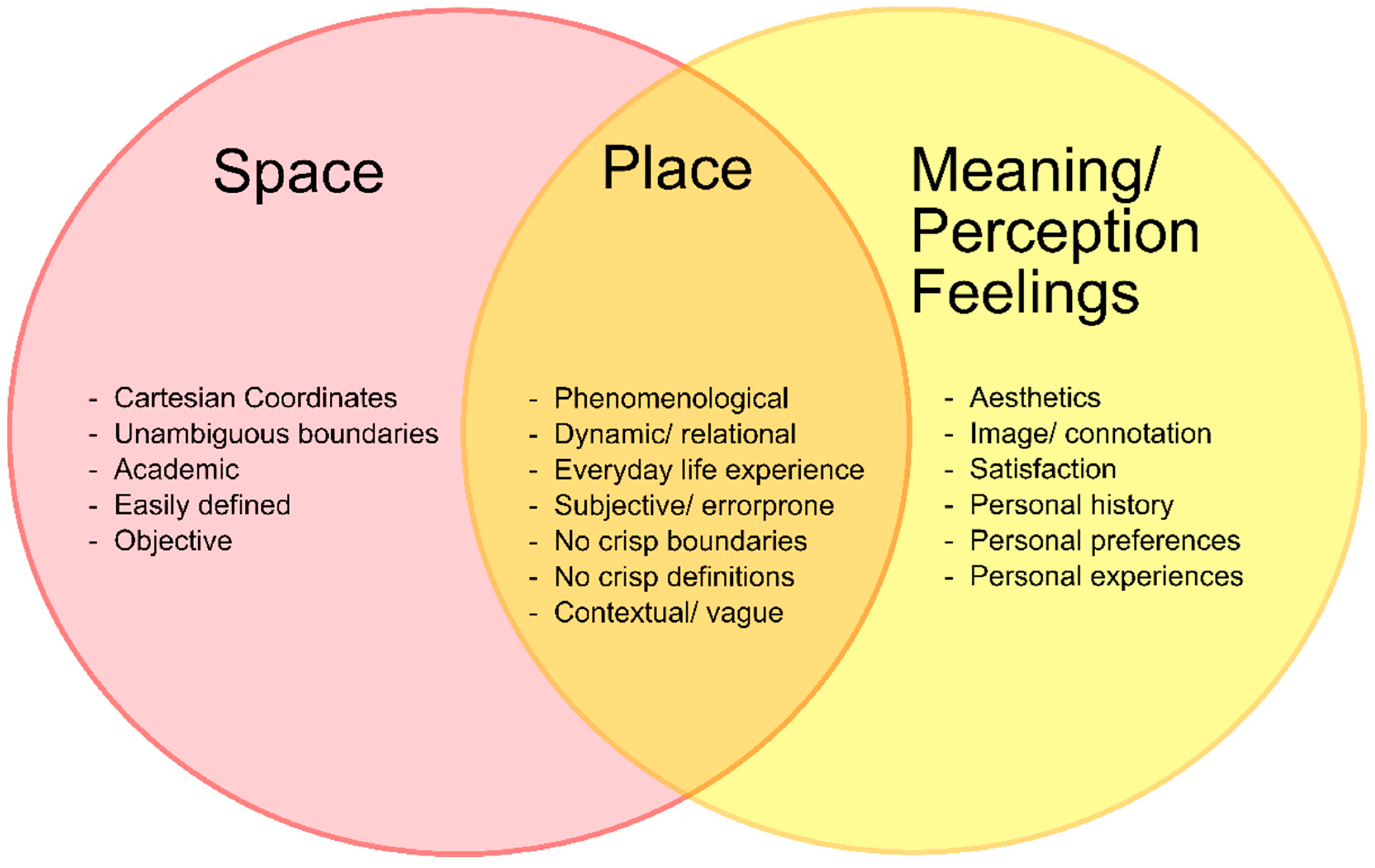
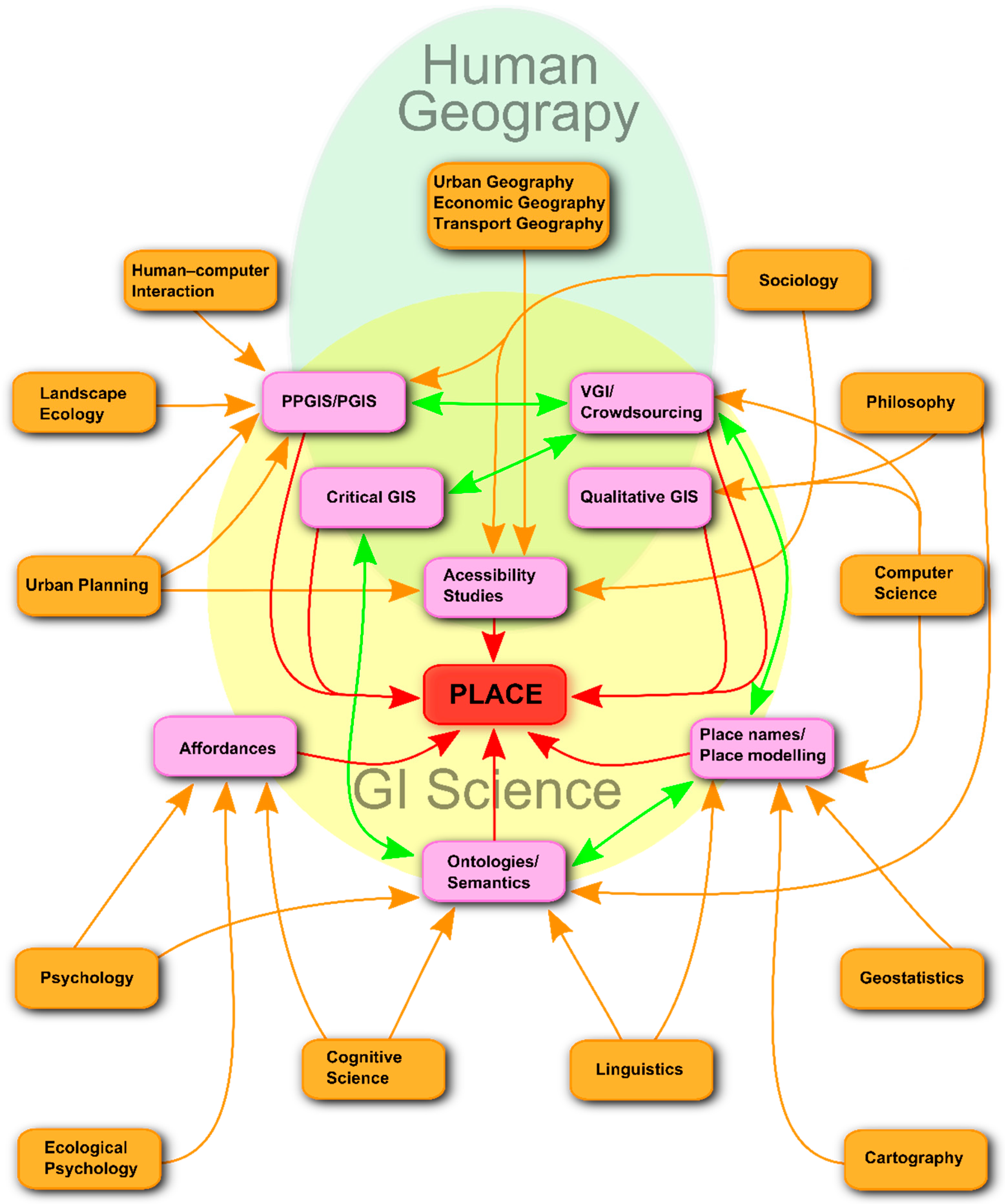
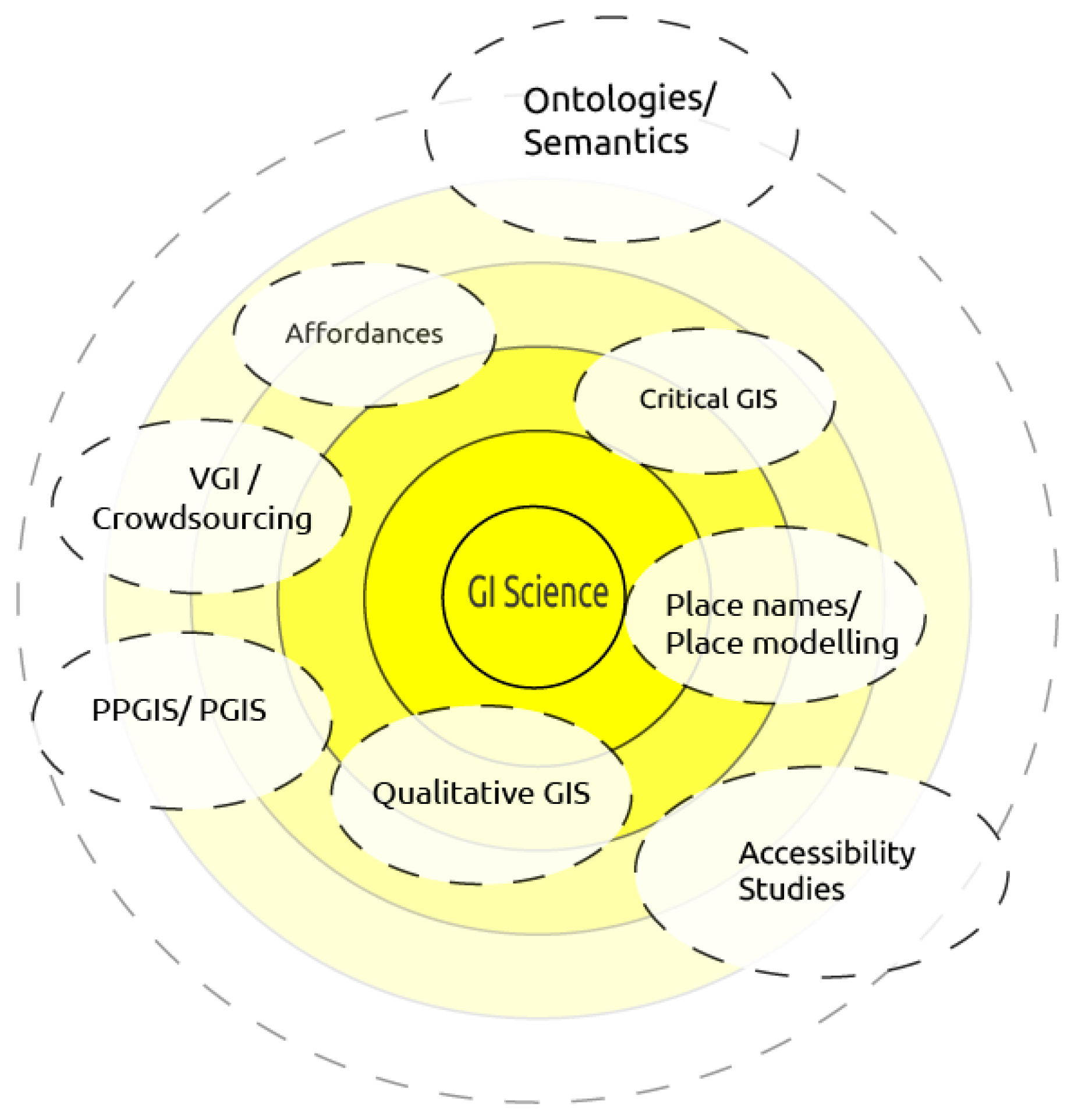
Table 1.
Branches of GIScience research concerned with place, and their respective methods.
| GIScience Branch | Methods Used | How Operationalized, How Many |
|---|---|---|
| Critical GIS | Engages with the representation of social concerns at the boundary between conceptualization and formalization [34] | Various case studies, particularly with minorities. Here, the more operational approaches often overlap with PPGIS. Scopus: 85 articles identified with a peak in 2015, cited 1228 times in total, 58 articles mention ‘place’, six papers cited >100 times, most cited papers [110,111] |
| Qualitative GIS | Most of the diverse approaches can be summarized with the term mixed-methods research. This may relatively simply mean using both, quantitative and qualitative methods. It can also lead to software-level modifications of GIS enabling the analysis of qualitative data sources [39] or to the integration of GIS and computer-aided qualitative data analysis software [36] | Many conceptual approaches exist, as well as some prototypical implementations, such as [36,39]. Scopus: 47 articles identified with a peak in 2015 but no clear tendency, 39 articles mention “place” cited 655 times in total, two often cited papers [112,113] |
| PPGIS/PGIS | Integrates local place-based knowledge through participatory approaches, either through face-to-face interviews or, increasingly, in a distributed online-based manner [108]. The majority of applications claim to contribute to decision making and democratization [45,49,114,115] | Many examples from around the globe, however, seems to be declining in favor of VGI/crowdsourcing. Several studies diagnose the number of long-lasting PPGIS solutions to be surprisingly low [48,116,117] Scopus: 513 articles identified, cited 4890 times in total, 209 papers mention “place”, most cited paper [118] |
| Affordances | Jordan et al. [54] conceptually propose a methodology including the affordances ‘agent’, ‘environment’ and ‘task requirements’ for modeling places, stating that the interplay of these factors results in different place definitions for each individual. Most of the approaches that try to implement affordances seem to use agent-based modeling software paradigm [119,120] | Few prototypical examples, e.g., as [56] approximate places to a special kind of media, which are bounded by a surface, and can be traversed, located, and move themselves, given that the affordance constituting them appears or disappears at some location Scopus: 39 articles identified, cited 584 times in total, 24 mention “place”, most cited paper [121] |
| Accessibility Studies | Accessibility is a classic GIS method tied to Euclidean space. More recently, researchers developed human-centred methods to account for the needs or perceptions of individuals or groups. For instance, Hawthorne & Kwan [58] developed a satisfaction-adjusted distance (SAD) measure to ‘correct’ real distances for the perception of persons. | Accessibility studies are a common topic in GIS. Technically, the methods are well advanced. Scopus: 1589 articles identified, cited 14,273 times in total, 437 mention “place”, most cited paper [122] |
| VGI/Crowdsourcing | Roche & Rajabifard [81] propose that VGI platforms should consist of four components, namely, input from a Spatial Data Infrastructure (SDI) providing spatial data from different sources, VGI input offering crowdsourced spatial information, an analysis tool which implements optimized models for decision making, and an information visualization tool | VGI studies and operational portals developed rapidly since around 2005. VGI/crowdsourced data has become ubiquitous with the emergence of mobile phones as portable sensors and geo-enabled online social media services. Accordingly, a large research community concerned with the analysis of such data has emerged in recent years. Scopus: 393 articles identified, cited 3088 times in total, 124 papers mention ‘place’, most cited paper [123] |
| Semantics/Ontologies | Agarwal [84] develops and conducts empirical tests to assess the shape and scale independent relations between cognitive conceptualizations of spatial entities, to assess ‘whether it is possible to specify basic topological operators for spatial concepts from cognitive conceptualizations (such as for region, neighborhood and place)’ [84] (p. 1). Bennett & Agarwal [82] examine the English vocabulary in terms of the meanings, connotations and ambiguities of various place count nouns such as ‘place’, ‘region’, or ‘area’, and subsequently identify meaningful underlying elements, which explain the similarities and differences between the different terms | Particularly ontologies have been used widely in Computer Science although their importance may have decreased recently. In GIScience, many examples of ontologies and their practical use exist. Semantics research cannot always be separated from the ontology domain but is even deeper rooted in and interlinked with linguistics. Scopus: 1414 articles identified, cited 10.167 times in total, 172 papers mention ‘place’, most cited paper [124] |
| Place Names/Place Modeling | Place-names research for gazetteers, e.g., Connection graphs to represent gazetteer footprints (e.g., [125]); Using ontologies to enrich gazetteers with terminological and spatial reasoning for better query results; Evaluating the semantic closeness of place-names to the queried topic of interest. Designing formal models to reason with place names in linguistic place descriptions—There are a number of formal models for qualitative spatial reasoning based on topological, directional or distance relations, or combinations thereof (See [88] p. 9), however, these still limit the possibilities to predefined relations | Having their origins in wayfinding, a sub-community on place modeling seems to have emerged within GIScience over the last years. Scopus: 139 articles identified, cited 1389 times in total, 121 papers mention ‘place’, two papers cited >100 times [126,127] |
Table 2.
Semi-quantitative analysis of the Branches of GIScience research concerned with place in Scopus (Elsevier).
Table 2.
Semi-quantitative analysis of the Branches of GIScience research concerned with place in Scopus (Elsevier).
| GIScience Branches | Articles | Cited by | Citation Average | Include ‘Place’ | Share of ‘Place’ | Uniqueness 1 |
|---|---|---|---|---|---|---|
| Critical GIS | 85 | 1228 | 14.45 | 58 | 68.2% | **** |
| Qualitative GIS | 47 | 655 | 13.94 | 39 | 83.0% | ***** |
| PPGIS/PGIS | 513 | 4890 | 9.53 | 209 | 40.7% | *** |
| Affordances | 39 | 584 | 14.97 | 24 | 61.5% | **** |
| Accessibility studies | 1589 | 14,373 | 9.05 | 437 | 27.5% | ** |
| VGI/Crowdsourcing | 393 | 3088 | 7.86 | 124 | 31.6% | ** |
| Semantics/Ontologies | 1414 | 10,167 | 7.19 | 172 | 12.2% | * |
| Place Names/Place Modelling | 139 | 1389 | 9.99 | 121 | 87.1% | ***** |
| Total (including some overlap) | 4219 | 36,374 | 8.62 | 1184 | 28.1% | ** |
| For comparison: | ||||||
| “GIScience” search in total | 1352 | 16,257 | 12.02 | 346 | 25.6% | ** |
1 The measure of uniqueness indicates to which degree articles in the assessed branch of GIScience address place-based GIS. More asterixis indicate a higher proportion of articles addressing place.
© 2018 by the authors. Licensee MDPI, Basel, Switzerland. This article is an open access article distributed under the terms and conditions of the Creative Commons Attribution (CC BY) license (http://creativecommons.org/licenses/by/4.0/).
Share and Cite
MDPI and ACS Style
Merschdorf, H.; Blaschke, T. Revisiting the Role of Place in Geographic Information Science. ISPRS Int. J. Geo-Inf. 2018, 7, 364. https://0-doi-org.brum.beds.ac.uk/10.3390/ijgi7090364
AMA Style
Merschdorf H, Blaschke T. Revisiting the Role of Place in Geographic Information Science. ISPRS International Journal of Geo-Information. 2018; 7(9):364. https://0-doi-org.brum.beds.ac.uk/10.3390/ijgi7090364
Chicago/Turabian StyleMerschdorf, Helena, and Thomas Blaschke. 2018. "Revisiting the Role of Place in Geographic Information Science" ISPRS International Journal of Geo-Information 7, no. 9: 364. https://0-doi-org.brum.beds.ac.uk/10.3390/ijgi7090364
Note that from the first issue of 2016, this journal uses article numbers instead of page numbers. See further details here.