Article

The Feasibility of a BIM-Driven Approach to Support Building Subdivision Workflows—Case Study of Victoria, Australia

1
Centre for Spatial Data Infrastructures and Land Administration (CSDILA), Department of Infrastructure Engineering, The University of Melbourne, Parkville, VIC 3010, Australia
2
Land Use Victoria, Department of Environment, Land, Water and Planning (DELWP), 2 Lonsdale Street, Melbourne, VIC 3000, Australia
*
Author to whom correspondence should be addressed.
ISPRS Int. J. Geo-Inf. 2019, 8(11), 499; https://0-doi-org.brum.beds.ac.uk/10.3390/ijgi8110499
Submission received: 9 October 2019 / Revised: 28 October 2019 / Accepted: 31 October 2019 / Published: 4 November 2019

Abstract

:
Cities are facing dramatic challenges due to population growth and the massive development of high-rises and complex structures, both above and below the ground surface. Decision-makers require access to an efficient land and property information system, which is digital, three-dimensional (3D), spatially accurate, and dynamic containing interests in land (rights, restrictions and responsibilities—RRRs) to manage the legal and physical complexities of urban environments. However, at present, building subdivision workflows only support the two-dimensional (2D) building subdivision plans in PDF or image formats. These workflows result in a number of issues, such as the plan preparation being complex, the examination process being labor intensive and requiring technical expertise, information not being easily reusable by all subdivision stakeholders, queries, analyses, and decision-making being inefficient, and the RRRs interpretation being difficult. The aim of this research is to explore the potential of using Building Information Modelling (BIM) and its open standards to support the building subdivision workflows. The research that is presented in this paper proposes a BIM-driven building subdivision workflow, evaluated through a case study in the state of Victoria, Australia. The results of the study confirmed that the proposed workflow could provide a feasible integrated mechanism for stakeholders to share, document, visualize, analyze, interpret, and reuse 3D digital cadastral data over the lifespan of a building subdivision project.

1. Introduction

The growing population and lack of available land in urban areas has led to an intensive property development above and below the ground surface [1]. Decision-makers require access to an efficient land and property information system, which is 3D, spatially accurate, and dynamic containing interests in land (rights, restrictions and responsibilities—RRRs), according to the Cadastre 2034 Strategy for Australia and New Zealand, to manage spatial and legal complexities of urban environments [2].
In addition, the emergence of complex multi-story structures in modern societies has resulted in significant challenges in data communication and management within current building subdivision workflows. These workflows typically include a wide range of stakeholders (e.g., cadastral surveyors, planners, developers, architects, councils, referral authorities, land registries, building managers, real estate agents, solicitors, and the public) that exchange 2D cadastral plans (in PDF or TIFF formats) and other relevant documents over the lifespan of a building subdivision application.
Several researchers have suggested using 3D models based on BIM to address issues that are related to fragmented 2D paradigms and improve the current building subdivision workflows [1,3,4,5,6]. This paper aims to contribute to this research domain by conducting a case study in Victoria, Australia, which explores the feasibility of a BIM-driven approach to support the building subdivision workflow in an integrated 3D digital environment.
Australia is among the most urbanized countries in the world [6]. Amongst the Australian jurisdictions, Victoria was selected as a good choice for understanding the current building subdivision workflows, as it is the most populated state with many urban developments. Victoria, with the population of 6,430,000 [7], is currently the fastest growing state in the country, with more than 2000 people moving to this state every week. In 2019, $78.9 billion of state capital projects have been commenced, developed, or delivered [8].
The Victorian Department of Environment, Land, Water, and Planning (DELWP), through Land Use Victoria (LUV), is responsible for all land information and administration activities in Victoria, including the registration of land transactions, property information, surveying, valuation, geographic names, spatial services, government land, and the government land monitor. LUV is also responsible for maintaining the Victorian cadastre, which is currently a 2D representation of the state’s property boundaries, based on property title information, and it provides the foundation data for Victoria’s primary mapping and spatial information systems and services.
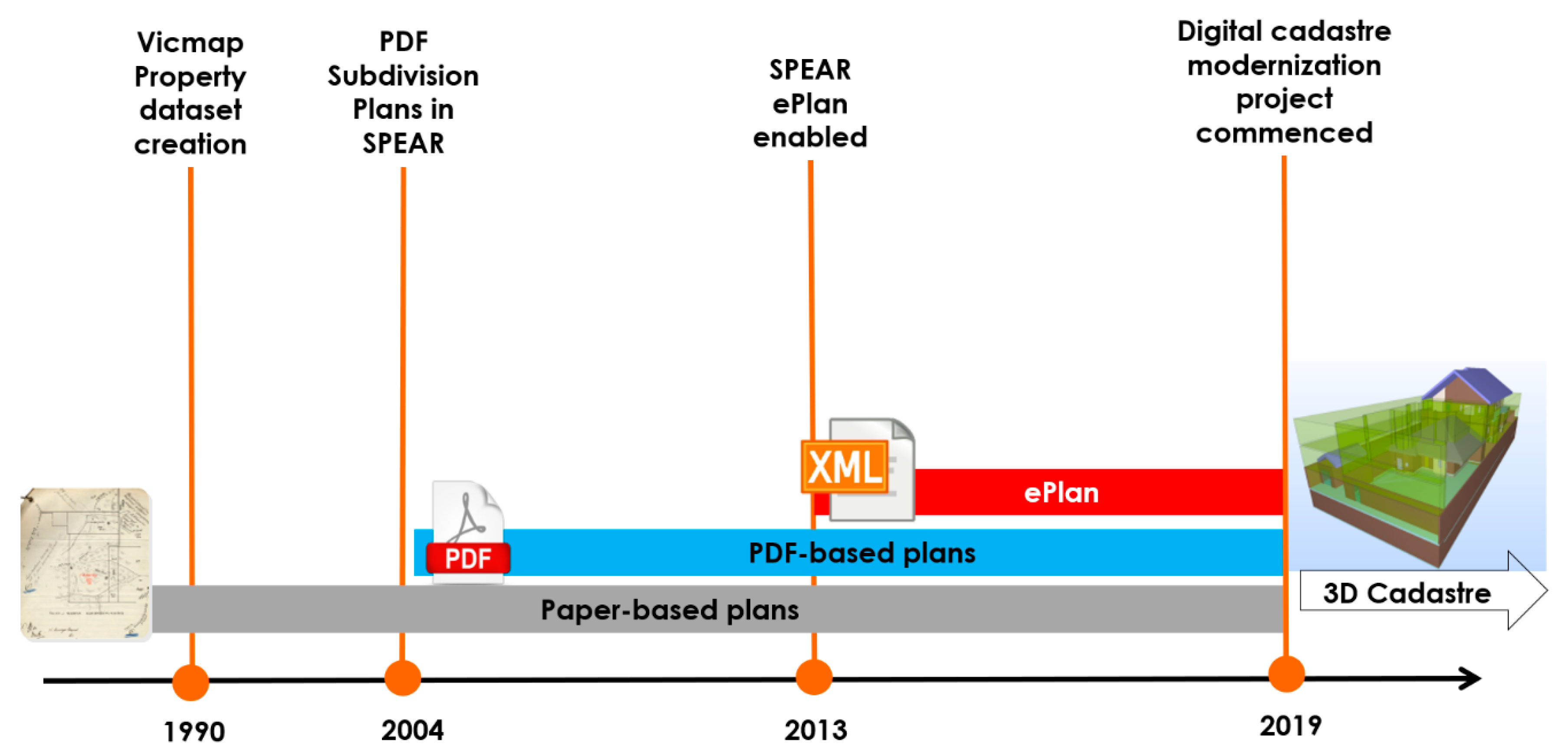
Figure 1 illustrates the Victorian land administration system modernization journey. Before the 1990s, cadastral plans were all lodged in paper format. Vicmap Property, the State Digital Cadastral Database (DCDB), was created in the early 1990s from the digitization of paper-based map records that are held by Melbourne Water (metropolitan area) and the state government (rural area). Vicmap Property comprises more than 3.3 million land parcels and associated property attributes, such as the lot and plan number, and crown description, in the State of Victoria.
In 2004, an online platform: ‘Surveying and Planning through Electronic Applications and Referrals (SPEAR)’ was developed to allow for subdivision planning permit and certification applications to be compiled, lodged, managed, referred, approved, and tracked online, anytime. SPEAR streamlined the subdivision process in Victoria and it replaced the paper plans with PDF plans.
According to Figure 1, by 2013, SPEAR supported the digital submission of cadastral plans in digital format (LandXML), namely ePlan [9]. All of the 2D plans under the Subdivision Act 1988 [10] are supported in ePlan. However, strata plans (building subdivisions) are not yet supported in ePlan.
In 2019, another major milestone was reached when LUV invested $45 million in the Digital Cadastre Modernisation Project to upgrade the digital cadastre, ensuring that one of the state’s most important datasets is accurate, useful, and easy to maintain.
The investigations around the 3D digital cadastre to support the building subdivisions in an ePlan format commenced in 2014. A 3D digital cadastre is expected to facilitate the registration process, save time and cost, increase transparency in land and property transactions, and improve land use and management [11,12,13,14,15,16,17]. For example, in a 3D digital cadastre, the overlapped spatial units can be validated, and geometries can be checked to ensure that rights are secured and disputes minimized [18,19].
While there have been scientific research projects around the world to enable cadastre with 3D digital technologies [3,20,21,22,23,24,25], these studies often address specific aspects of cadastre, such as 3D visualization, 3D validation, 3D storage, and 3D data modelling. As a result, a roadmap was required for integrating these initiatives and identifying the critical steps towards the transformation of the existing cadastre system into an operational 3D digital cadastre system for Victoria.
Accordingly, a roadmap was developed for implementing the Victorian 3D digital cadastre by 2025 [26]. The roadmap recommends the replacement of PDF building subdivision plans with 3D cadastral data and the development of a digital and integrated building subdivision workflow to accommodate 3D data.

1.1. Research Problem

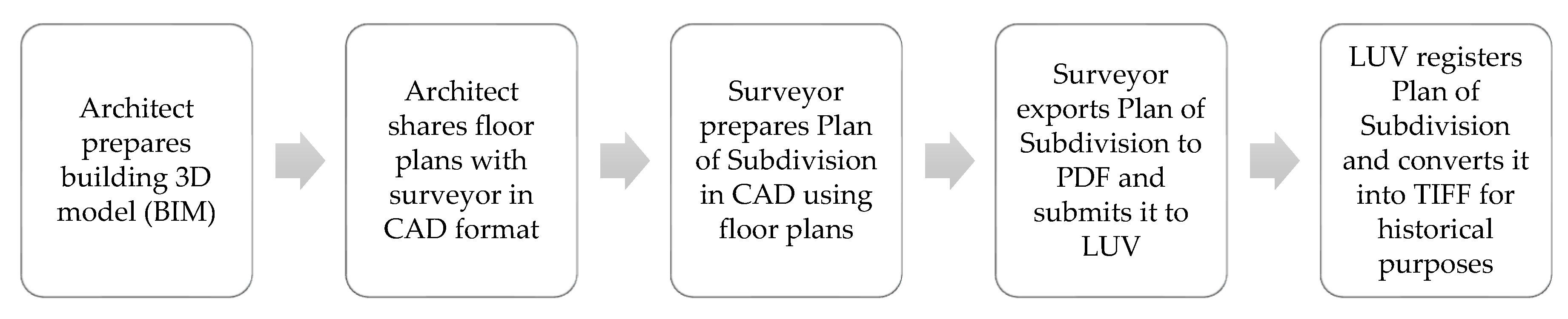
In Victoria, regulations allow for registering overlapped RRRs in 3D under the Subdivision Act 1988. These RRRs are recorded and registered in paper or PDF-based plans while using floor plans and cross-sections. As illustrated in Figure 2, the building 3D model in a BIM format is downgraded to a PDF and then to a TIFF image throughout the lifespan of building subdivision and registration in Victoria.
The current 2D PDF-based approach for exchanging cadastral data among the Victorian land administration stakeholders (e.g., planners, developers, architects, councils, real estate agents, strata managers, utility companies, the public) and visualizing RRRs has resulted in some limitations, as summarized below:
  • Plan preparation is complex and often results in queries (e.g., what are the ownership boundaries? What is the extent of a common property?) and errors (e.g., lack of required cross-section diagrams).
  • The examination process is labor intensive and it requires technical expertise.
  • Land administration stakeholders cannot readily and efficiently use information.
  • Queries, analyses, and decision-making are possible, but not efficient.
  • Difficult for the public to understand their RRRs.
  • Plan interpretation between two parties can be different.
The research problem underpinning this paper can be summarized as the current building subdivision workflow in Victoria is predicated on silo-based and fragmented 2D approaches that do not provide an environment for stakeholders to share, document, visualize, analyze, interpret, and reuse 3D digital cadastral data over the lifespan of a building subdivision project.

1.2. Research Aim

There is a need for the Victorian subdivision workflow to shift from a 2D PDF-based approach to a 3D digital integrated approach to address the above-mentioned research problem. Therefore, this study aims to explore the potential of using BIM (the 3D data prepared by architects at the beginning of building subdivision process, as shown in Figure 1) to support the building subdivision workflow, as recommended by the Victorian 3D digital cadastre roadmap.
The remainder of this paper is structured, as follows. Section 2 provides an overview of relevant research experiences regarding the workflows developed for a 3D digital cadastre. The research methodology has been discussed in Section 3. Section 4 explains the case study outcomes. Section 5 provides a set of criteria for comparing the current and proposed building subdivision workflows and discusses the findings. The paper concludes in Section 5 with a summary of findings and direction for future research.

2. Review of Relevant Literature

The goals of land administration systems are similar in all countries: every society needs a system that provides information on land ownership, which offers additional documentation required over the entire lifecycle of the land subdivision. Therefore, land ownership is the main focus of land administration systems and documents provide the evidence to support land administration processes. The processes are needed to update ownership RRRs attributes and restructure space by changing the shape and number of the parcels [27]. This signifies the fact that understanding, using, and improving a cadastral system requires knowledge on the cadastral processes [28].
Urban land is characterized by the dominant existence of multi-story buildings. The current workflows for subdividing land and property ownership in multi-story buildings include various 2D datasets and documents exchanged between different actors. The fragmented nature of these workflows has led to significant communication and management issues in various stages of complex building subdivision projects. Therefore, more integrated approaches, such as BIM, are being explored for improving communication and collaboration among actors.
BIM is a new integrated process that is increasingly being adopted by the Architecture, Engineering, and Construction (AEC) sector to describe, model, and publish all of the documentation required for constructing buildings and complex structures [29]. It is becoming a dominant paradigm to provide a spatially, temporally, and semantically accurate multi-dimensional data environment for facilitating communication and collaboration in the AEC industry. BIM is a multidisciplinary process for improving communication over the design, construction, and maintenance phases of complex developments. The key result of the BIM process is a BIM product that includes a rich spatial and semantic description of all assets within a development [30]. This digital product relies on information that is captured and curated by a wide range of stakeholders at important milestones of the project lifecycle. The BIM process has created a significant paradigm shift in the AEC industry over the last decade by introducing an integrated approach for communicating and sharing building information [31]. The BIM process has changed the traditional document-driven methods of collaboration to 3D digital model-based workflows in the AEC industry [32].
The current BIM platforms use their own proprietary data formats and workflows to manage BIM data. However, these specific workflows and data formats may not interact well over the entire lifecycle of a building subdivision. Therefore, open BIM standards and workflows have been developed to resolve this issue. Open BIM standards and workflows provide a universal mechanism for supporting integrated design, realization, and operation of buildings [
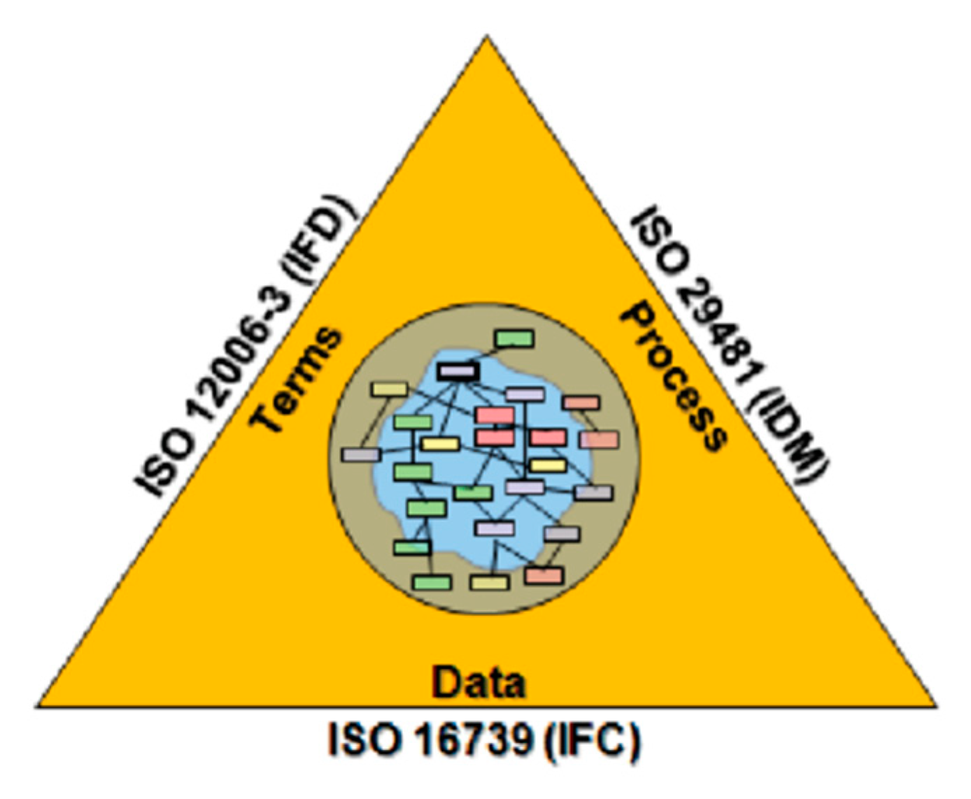
33]. The objective of open BIM is achieving an improved planning, design, construction, operation, and maintenance process while using a standardized machine-readable information model for each facility, new or old, which contains all appropriate information, created or gathered, about that facility in a format useable throughout its lifecycle by all. As depicted in Figure 3, open BIM has three major parts: (1) Information Delivery Manual (IDM), (2) International Framework for Dictionary (IFD), and the (3) Industry Foundation Classes (IFC) data model. IDM is a standard for the processes of the work [34], IFD is a standard for the terminology that is used in the processes [35], and IFC is a standard data model for data management and information exchanges [36].
BIM can play a critical role in realizing 3D land administration systems [6]. As opposed to the traditional 2D-based practices, BIM can provide much more detailed information related to 3D cadastral purposes; however, sometimes the information in BIM can be too detailed, and a simplification process is required [37]. Atazadeh at al. [
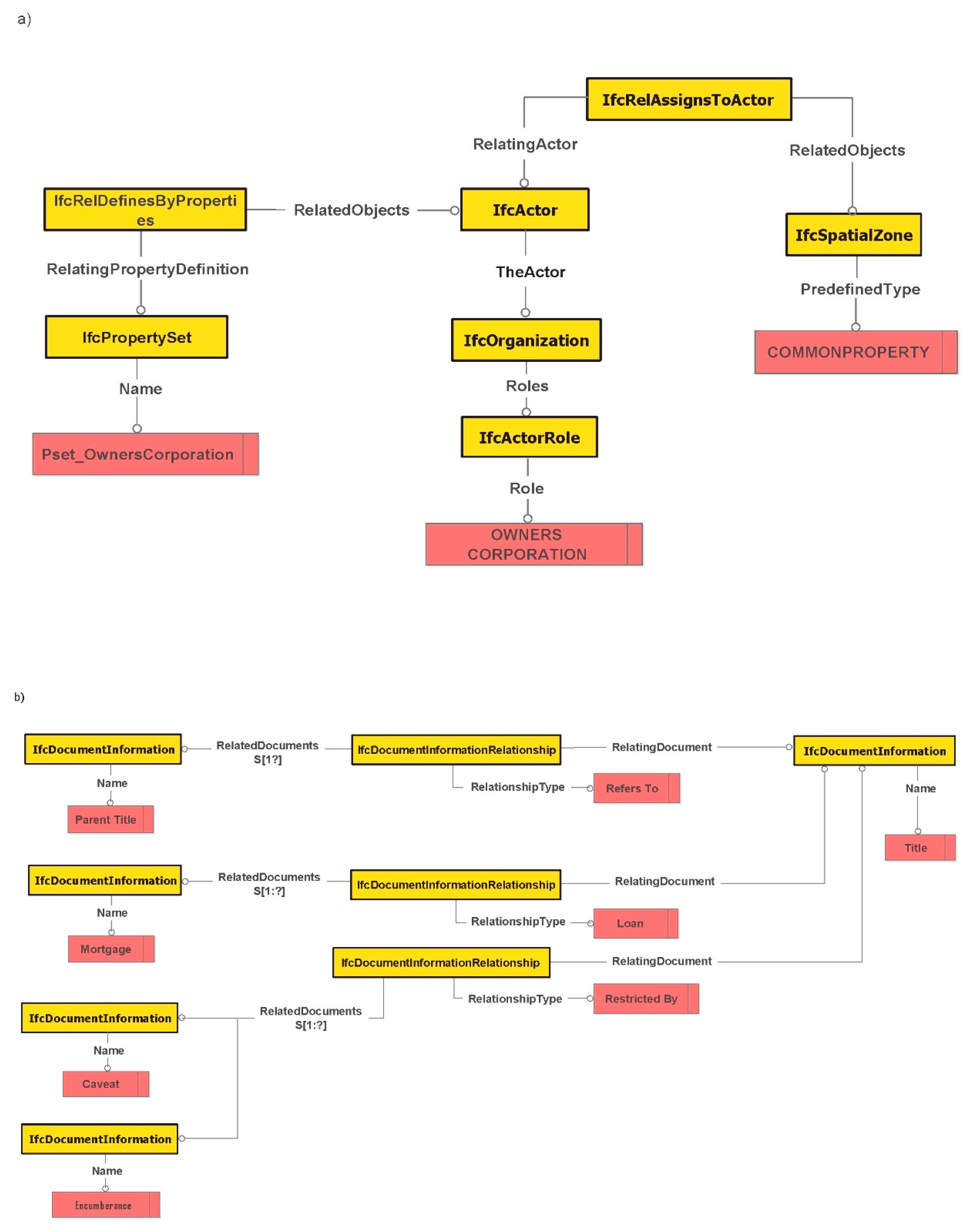
14] extended BIM to support the digital management of 3D cadastral data resulting from building subdivisions. Relevant spatial and physical elements within the open BIM data model, known as IFC, were identified as potential entities that are extended to support 3D cadastral data management within the BIM environment. Their main contribution was extending the concept of spatial zones and space boundaries in IFC to lay the foundation for managing complex 3D cadastral spaces [38,39]. They implemented a prototype model to emphasize the feasibility of the extended BIM-based data model for land administration and then proved the effective visualization and management of ownership arrangements in complex urban areas. In the context of the Swedish jurisdiction, the feasibility of BIM has been investigated for the 3D cadastre [40,41]. In the Netherlands, Stoter et al. [42] proposed an implementation of a 3D registration of 3D property rights that were fitted to the LADM standard.
The lifecycle of 3D cadastral spaces and their associated rights, restrictions, and responsibilities is made up of many different parts and substages [43]. The submission of 3D BIM in an IFC format would allow for data to be digitally archived, remain available and accessible in the long term and be stored in a machine-readable data model. Where PDF merely documents the graphical appearance of a work in a printer friendly environment, IFC allows for publishing the underlying semantics [3]. Oldfield et al. [
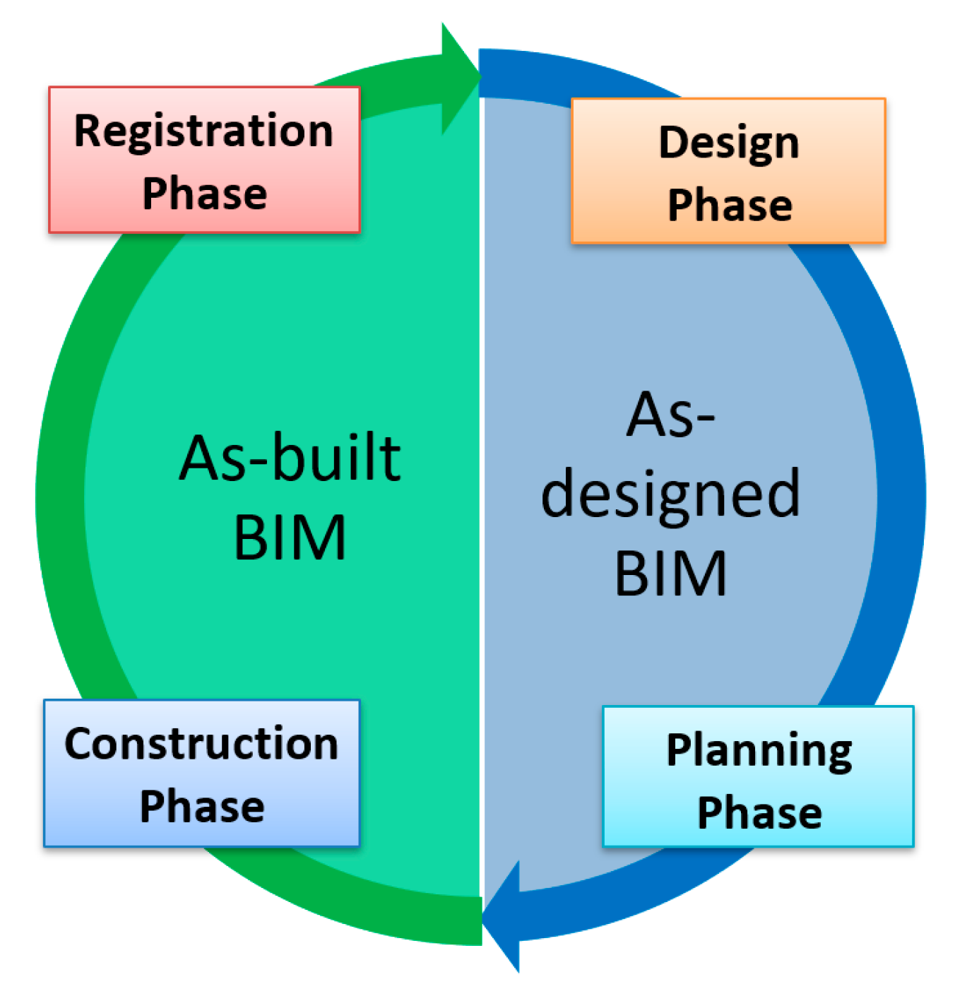
5] investigated using BIM as the input data for 3D cadastre. According to their research, obtaining data is only one part of the process for moving from 2D to 3D land administration systems. An efficient collaborative workflow, preferably digital, also needs to be developed. This digital workflow would determine what the 3D Cadastre needs from a 3D BIM and the process of extracting it in addition to exchange requirements. They confirmed that IFC would need to be enriched further to satisfy the requirements of cadastral legal spaces. Enriching IFC would enable data for a 3D cadastre to be extracted from both as-designed and as-built BIMs.
Over the past decade, researchers around the world have been investigating the incorporation of 3D cadastral data into land subdivision workflows. These workflows will vary case by case from country to country and they will be driven by user needs, market forces, the legal framework, and what technology is available [43]. Guo et al. [44] discussed that, similar to the traditional 2D cadastral business in the Shenzhen city of China, the 3D business workflow is divided into three steps: project preliminary, project design, and project construction. In the Dutch jurisdiction, 3D data and collaboration are crucial in the creation and success of a 3D cadaster [3]. 3D spatial units can be obtained from enriched IFC files, which make property units explicit and submitted as part of digital permit applications. Oldfield et al. [5] proposed a new IDM-based workflow for registering 3D legal spaces in the context of the Dutch jurisdiction. The workflow focused on the efficient communication of cadastral data requirements between project developers and authorities by obtaining 3D legal spaces from BIM models. One issue with the proposed workflow is that it did not distinguish the specific acting roles performed by various authorities that are involved in the entire subdivision workflow. For instance, the role of responsible authorities, such as councils, was not distinguished from referral authorities, such as utility companies.
More recently, Oldfield et al. [3] developed a coordinated process for requesting and granting building permits while using IDM-based workflows. The interactions between project developers and municipalities are mapped onto two phases: pre-construction and post-construction. In these interactions, the assumption was that the building approval process relies on BIM models that are embedded with spatial units, RRRs information, and survey measurements. In the pre-construction phase, the as-designed BIM models are used for granting or declining the building permit. In the post-construction phase, as-built BIM models are examined to finalize a building permit application. Using XML-based tools was also suggested for automating multi-actor collaboration and communication during the process of a building permit application.
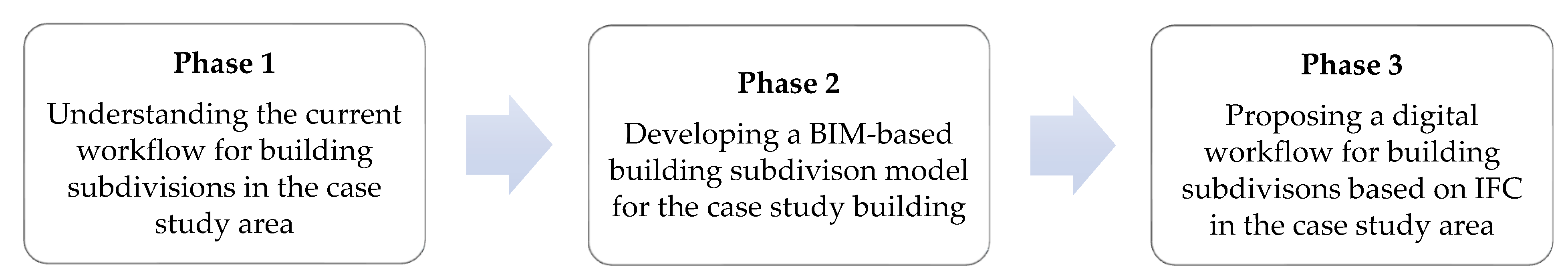
The above reviewed investigations indicate that there is limited research regarding the viability of a BIM environment to support the entire lifecycle of a building subdivision workflow. In the specific case of the Victorian state in Australia, there is no single study that looked at developing a BIM-driven approach for managing building subdivision workflows. Therefore, in the next section, we will develop a generic approach for supporting a 3D model-based subdivision workflow that is predicated on the BIM environment.

3. Research Methodology

A case study was defined and developed by the authors to develop a digital workflow based on BIM for building subdivisions in Victoria. The case study aimed to compare the current building subdivision workflow for a selected building subdivision PDF plan against the proposed 3D-model based building subdivision workflow while using BIM for the same plan.
The case study was undertaken based on the phases that are illustrated in Figure 4.
In Phase 1, the current workflow for building subdivisions in Victoria was studied in detail. This phase defined the current workflow’s requirements. Phase 2 aimed at developing a 3D building subdivision model in BIM. As part of this phase, physical (e.g., wall, ceiling, roof, and window) and legal (RRRs) components of a sample building subdivision plan were both modelled in an IFC format. In Phase 3, a digital workflow based on IFC was proposed to replace the current workflow. The details of each phase have been discussed in the next section.

4. Case Study

4.1. Phase 1—The Current Workflow

In Victoria, SPEAR, which was previously introduced in Section 1, revolutionized the way subdivision applications were handled, by introducing online end-to-end processing and the tracking of plan applications from their initial submission with local government, right through to registration at land registry (LUV). Subdivision applications could only be processed via paper prior to the launch of SPEAR in 2004. This was generally a lengthy and protracted process that was instigated by the surveyor, on behalf of their client (developer). The process and application milestones are well defined by the Planning and Environment Act 1987 [45] and Subdivision Act 1988 [10]; however, achieving these milestones, in a paper environment, where there are multiple stakeholders involved in the decision-making process led to delays, errors, and poor transparency between the interested parties.
SPEAR introduced invaluable transparency and accountability to the subdivision application process by streamlining the approval process for plans of subdivision, and the associated planning permit to subdivide. The system is now being used by all 79 Victorian local governments, 219 surveying firms, 53 referral authorities, 150 lodging parties, and LUV, which, in total, represent over 4000 users to view the progress of applications.
Figure 5 illustrates the building subdivision workflow supported by SPEAR. This workflow includes four major phases: design, planning, construction, and registration.

4.1.1. Design Phase

This phase includes selecting the location of the building and preparing its design. The developer starts the process by identifying a suitable land for the development of the building by considering a wide range of economic, social, and environmental criteria. The real estate agent provides the developer with the conditions and preferences in the land market. Once the suitable land has been identified, the land surveyor conducts the site survey to establish boundaries for the land. Meanwhile, the architect utilizes CAD or BIM software tools for creating the design model of the building and its physical elements. Once the developer agrees on the design model of the building, the land surveyor receives 2D floor plans as well as cross-section diagrams from the architect. The land surveyor uses 2D architectural plans to create subdivision plans. The subdivision plans are used to represent the legal boundaries and ownership rights in buildings. The 2D subdivision plans include notation information, cross-floorplans, and section diagrams.

4.1.2. Planning Phase

In this phase, the 2D subdivision plans are prepared and a planning permit is issued. The land surveyor prepares 2D subdivision plans and submits an application for issuing the planning permit to the council. The council assesses the subdivision application based on various state and local planning schemes. The council might also decide to undertake the referral of the subdivision application by submitting the proposed subdivision to different referral authorities, such as utility companies. The referral authorities are likely to hold interests over easements and restrictions that are to be created, varied, or removed by the proposed subdivision. In addition, the referral process ensures that the responsibilities and assets of referral authorities are not adversely affected by the proposed subdivision.

4.1.3. Construction Phase

After issuing the planning permit and certifying the subdivision plan by the council, the builder commences the construction of the building. In this phase, several requirements, which are mainly conditions considered on the permit in the planning phase, should normally be addressed to the satisfaction of the council or referral authorities. There are two types of requirements, including open space provision and subdivision works. Once the construction is completed, the land surveyor submits applications for both a “Statement of Compliance (SOC)” and “Certificate of Occupancy” to the council. The council assesses the SOC application to ensure that the building has been constructed according to the conditions that are mentioned in the planning permit. The “Certificate of Occupancy” application is assessed to certify that the building is appropriate for occupation based on the building regulations.

4.1.4. Registration Phase

This phase mainly includes the registration of subdivision plans and recording the legal information in the cadastral database of the land registry. The land surveyor lodges the subdivision plans to the land registry. The land registry examines the subdivision plans to check the logical correctness of all the legal boundaries based on a wide range of examination rules. Finally, the subdivision plans will be registered and the land registry updates the cadastral database.

4.2. Phase 2—Case Study Dataset Preparation

For the case study, a building subdivision plan, namely PS704971N, was selected. The relevant SPEAR application has the below stakeholders (actors):
  • Surveyor: Dickson Hearn Pty Ltd.–Melbourne
  • Council: Port Phillip City Council
  • Referral authorities: Comdain Infrastructure/Multinet Gas, Melbourne Water, South East Water, Victorian Power Networks–Urban, ZNX/Multinet Gas North
  • Lodging party: David Moses Lawyer
  • Land Use Victoria
This plan has 12 lots and two common properties. Similar to other building subdivision plans, this plan includes floor plans and cross-sections, as illustrated in Figure 6. Floor plans and cross-sections assist in defining and understanding the overlapped ownership rights in building subdivision plans.
Architectural plans were requested and received from the associated surveying firm in DWG format to develop a 3D model of this building subdivision plan in BIM. Autodesk Revit was utilized to create a 3D model that is based on the architectural plans (Figure 7a). Next, subdivision plans were used to define ownership boundaries in Revit. According to Shojaei et al. [11], legal objects were defined as Room Components within the 3D model. Finally, the model was exported in an IFC format (BIM). As the IFC format does not support legal objects, all legal objects (lots and common properties) were defined as IfcSpace (Figure 7b). In addition, attribute data for each legal object were added to the 3D model.

4.3. Phase 3—Proposed Workflow

The proposed workflow uses the open BIM environment, i.e., IFC standard, as a central data repository to manage the subdivision lifecycle. In the BIM-driven workflow, information related to all actors and legal documents exchanged during the subdivision lifecycle are all linked to the BIM model. In the next subsections, we will show the modelling of subdivision actors and referencing legal documents in the BIM model.

4.3.1. Modelling Subdivision Workflow Actors in IFC

The role of the actor should be defined to model a subdivision actor within the IFC standard. The IfcActor entity is used for defining all types of actors that are involved during the lifecycle of buildings. This entity includes the TheActor attribute, which provides the ability to choose from three types of actors: a person (IfcPerson), an organization (IfcOrganization), and a person acting on behalf of an organization (IfcPersonAndOrganization). All of the IfcPerson, IfcOrganization and IfcPersonAndOrganization entities include the Roles attribute that references the IfcActorRole entity to define the role that is performed by an actor. The IfcActorRole includes three important attributes:
  • Role: This attribute provides the name of the role performed by an actor. It refers to the IfcRoleEnum enumeration, which includes a wide range of values for various actor roles. Among land administration actors, the OWNER actor role has already been defined as a value for this enumeration.
  • UserDefinedRole: This attribute provides the capability to define those actor roles that are not already defined within the IfcRoleEnum enumeration. For instance, the CITY COUNCIL actor role can be defined by this attribute. It should be noted that if a user defined role is defined, the USERDEFINED value should be chosen for the Role attribute.
  • Description: This attribute provides further information about the nature of the actor role.
Once the actors and their roles have been defined, they should be assigned to the objects for which they are responsible. The IfcRelAssignsToActor objectified relationship is used to handle the assignment of actors to the IFC objects. This assignment can be completed using three attributes:
  • RelatingActor: It references the IfcActor entity which provides information describing the actor itself
  • ActingRole: The role that the actor plays within the context of the assignment
  • RelatedObjects: It refers to those objects, which are legal interests in this context, for which the actor is responsible.
Figure 8a illustrates an example of assigning a legal object that is defined inside a BIM model to a subdivision actor. In this assignment, the common property is assigned to the Owners Corporation Manager with the acting role of “manage”. Likewise, all other actors can be assigned to their corresponding legal objects while using a similar approach. Table 1 provides a list of actor roles with their corresponding legal objects.

4.3.2. Referencing and Managing Legal Documents Exchanged in the Subdivision Workflow within IFC

It is a requirement to instantiate the IfcDocumentInformation entity for each legal document when referencing and managing information relating to legal documents. This entity currently provides a rich amount of metadata for documents [6]. The other required attributes for legal documents, such as Volume and Folio Number, can be provided through the Description attribute or referencing the URL for the location of legal documents. Table 2 provides these extra attributes for each legal document.
It is also possible to instantiate the IfcDocumentInformationRelationship entity to define relationships between the two documents. In the proposed IFC extension, this entity is used to define relationships between the title document and other legal documents, such as the mortgage and caveat, created in the registration phase of the building subdivision process (see Figure 8b).
The IfcDocumentInformationRelationship entity has three specific attributes to relate two legal documents:
  • RelatingDocument: This attribute refers to the document that acts as the referencing document in a relationship. In this study, the relating document is the “Title” document.
  • RelatedDocuments: This attribute refers to documents that act as the referenced documents in a relationship. The related legal documents here are “Parent Title”, “Mortgage”, “Caveat”, and “Encumbrance”.
  • RelationshipType: The value of this attribute describes the type of relationship between two legal documents. For example, the relationship type between “Title” and “Parent Title” is “Refers to”, while “Restricted By” is the relationship type between “Title” and documents imposing restrictions on the tittle, such as “Caveat” and “Encumbrance” (see Figure 8b).
Among the legal documents that are mentioned in Table 2, the title document is directly associated with primary legal interests as well as their interest holders (see Figure 9a). For instance, IfcRelAssociatesDocument can be used to relate the title document to its owner and lot. The RelatingDocument attribute should refer to the title document information. Here, the RelatedObjects attribute should include both the IfcActor and IfcSpatialZone entities, which are respectively used to model an owner and a multi-part volumetric lot.
Some legal documents are exchanged between land surveyors and councils. These include the planning permit, certification, statement of compliance, and engineering plan. The IfcApproval entity can be used to define data elements that are used in the approval process of these documents (see Figure 9b). Those attributes of the IfcApproval entity, which are essential in the context of urban land administration, are described in Table 3.

4.3.3. Administrative Information

There are two types of administrative data elements: the survey header and plan information. The survey header provides information relating to the location of the development, such as the geographic coordinates and postal address, which have already been provided as attributes in the IfcSite entity (see Table 4). Plan information can be added as a property set, which is assigned to the IfcProject entity (see Figure 10). Table 5 illustrates this property set.

4.3.4. Implementation of a BIM-Based Subdivision Workflow for the Case Study

A BIM-driven approach is developed for the case study building, according to the IFC extension that is proposed in Section 4.3.1, Section 4.3.2 and Section 4.3.3. In this workflow, all subdivision actors communicate within the common data environment of BIM (see Figure 11). Therefore, information relating to actors and legal documents exchanged over the subdivision lifecycle are stored and linked in the BIM environment. The proposed BIM-based workflow affects the way that subdivision actors communicate with each other. This workflow replaces the 2D subdivision plans with a BIM model for all phases. In addition, information related to subdivision actors, planning permits, and legal documents are incorporated inside the BIM environment.
In the design phase, the architect creates the architectural BIM model, which only includes the physical objects of the building. Afterwards, the land surveyor enriches this physical BIM model by adding legal boundaries, ownership rights, and attributes, as well as administrative information. This results in an integrated as-designed BIM model that includes both legal and physical objects (see Figure 12). As described in Section 4.3.3, administrative information is also linked to the BIM model (see Figure 12).
The land surveyor incorporates the planning permit request information to the integrated as-designed BIM model and then submits it to the council. The council adds the planning permit ‘grant’ or ‘reject’ information to the subdivision information and links the relevant legal documents, such as the planning permit or notice to rejection, to the integrated as-designed BIM model. Figure 13a shows planning approval attributes for the case study building. These attributes are stored in the BIM model, which also provides the link to the planning permit document.
In the construction phase, the integrated as-designed BIM model is updated according to the constructed reality of the building. Therefore, the integrated as-built BIM model is created in this phase. The ‘Statement of Compliance’ document is externally linked to the BIM model, as described in Section 4.3.2. In the registration phase, the lodging party lodges the integrated as-built BIM model to the land registry, which is Land Use Victoria in our case study. The land registry examiners check the as-built BIM model based on the examination rules. Some of these checks can be automated by developing 3D data validation approaches. During the examination, the land surveyor updates the BIM model if the examiner requires any changes. After passing the examination, the land registry registers the as-built BIM model and associated legal documents, such as titles, mortgages, and caveats, are externally linked to the integrated as-built BIM model. Figure 13b shows the relevant registration approval attributes that are stored in the BIM model.

5. Discussion

The BIM-driven approach, as proposed in Section 4, provides a new window of opportunities in managing the entire lifecycle of building subdivision processes. While the current subdivision workflows rely on 2D-based fragmented document sharing and exchange, the BIM-driven subdivision workflow that is proposed in this study provides an integrated and common data environment to facilitate communication and collaboration among a wide range of stakeholders that are involved in the various phases (including design, planning, construction, and registration) of building subdivision. To compare the current and proposed building subdivision workflows, as discussed in Section 4, the following set of criteria was developed:
  • support of international standards;
  • support of digital data sharing and re-use;
  • support of data integrity;
  • support of data analysis;
  • support of 3D data visualization;
  • support of plan pre-lodgment validation;
  • support of digital plan examination;
  • support of cadastral map base update automation; and,
  • ease of RRRs interpretation.
Table 6 provides a comparison between current and proposed workflows against the above-mentioned set of criteria.
As previously discussed, SPEAR has significantly streamlined the land and building subdivision process in Victoria; however, the subdivision process itself is not based on international standards. The proposed workflow bridges this gap by aligning the subdivision process with the BIM standards. As opposed to the current fragmented building subdivision data structure in SPEAR (multiple PDF files for plans and associated documents) that has led to significant communication issues in various stages of complex building subdivision projects, BIM will provide an integrated environment that improves communication and collaboration among all the actors (stakeholders).
The proposed workflow aims to prevent BIM from becoming electronic waste by effectively making use of the rich dataset that was prepared by the architects at the beginning of building subdivision process. However, the proposed workflow needs to ensure that the as-built BIM models replace the as-designed BIM models when the building subdivision application gets released at land registry (LUV) for examination and registration purposes.
LUV is currently investigating the IP issue for sharing both ePlans registered in SPEAR and ePlans that were created through the digital cadastre modernization project with the subdivision process stakeholders. The potential solution will also be applied to BIMs being exchanged amongst the subdivision stakeholders in the proposed workflow.
Analyzing the data available in PDF format is not efficient. In comparison, BIM provides a rich data environment that captures complex relationships between legal boundaries, ownership arrangements, and their counterpart physical elements, and thus provides spatial and non-spatial queries capability [49].
The Victorian 3D digital cadastre roadmap, as introduced in Section 1, has considered the development of 3D data validation and examination services. The proposed workflow would enable surveyors to undertake a pre-lodgment validation check to identify the potential errors in their 3D building subdivision models, which results in minimizing requisitions during the examination process. Examples of validation checks include clash detection, title boundary consistency between created and cancelled parcels, and parcel geometry closure [49]. In addition, the proposed workflow will support using BIM models in a digital plan examination platform that has the provision of automating some of the plan examination checks (e.g., survey re-establishment) through overlaying the 3D model on top of the digital cadastre map base in an intuitive environment.
Maintaining the digital cadastre map base using PDF plans is very challenging. SPEAR advises surveyors to upload their CAD files to their applications; however, surveyors either ignore this optional requirement, or provide CAD files in different structures and formats. BIM will standardize the structure and format of digital building subdivision plans, which leads to facilitating the map base maintenance process in the future.
Following the current 2D PDF-based visualization of RRRs, the two most common questions that LUV receives from the public include: (a) What are my ownership boundaries? and (b) What is the extent of the common property? The proposed workflow will simplify the interpretation of subdivision plans through visualizing 3D models in web-based, virtual reality (VR), or augmented reality (AR) applications [55].
All building subdivision stakeholders need to adopt some technical and institutional changes, which will enforce extra cost to their business, in order for the proposed workflow to be implemented within SPEAR and become fully functional in Victoria. Examples include the cost for hardware/software upgrade, building new infrastructure to work with BIM models, learning new skills and technologies, hiring skilled staff, capturing 3D data from the field, etc. Surveyors will need to capture 3D data and prepare the as-designed and as-built BIM models containing RRRs. Councils will need to have the required skills and infrastructure to assess BIM models for issuing planning permits and filling in relevant IFC attributes. Similarly, the Referral Authorities will need to have required skills and infrastructure to visualize BIM models, locate their assets within them, and fill in the required IFC attributes. LUV will need to enhance SPEAR to accept BIM lodgments. Additionally, some new services, such as BIM validation, visualization, and examination, need to be developed within SPEAR. In addition to technical and institutional changes, some legal changes will be required that should be managed by LUV, e.g., BIM models replacing PDF plans in the contract of sales and dispute resolution processes.
Our case study was conducted in Victoria, Australia; however, our approach for developing a BIM-driven workflow can be adapted for other countries or states. The cadastral system of each country or state is unique. A good understanding of building subdivision data and process requirements in that jurisdiction is required to use the proposed workflow for building subdivisions in the context of another jurisdiction.

6. Conclusions

This paper explored the potential of a BIM environment to support 3D digital building subdivision workflows. The current workflows rely on document-centric approaches that are fragmented and manage the lifecycle of subdivision in information silos. Therefore, the major contribution of this study was extending the open BIM standard with subdivision lifecycle information to provide a 3D digital common data environment for sharing and exchanging information related to subdivision actors and documents. The outcomes of this research could be expanded to realize a BIM-enabled SPEAR system in Victoria. The design and implementation of such a system can demonstrate that SPEAR can be equipped with BIM to manage the entire lifecycle of legal and physical information, from the design to the registration phases, in a 3D environment, which would subsequently lead to implementation of a 3D digital cadastral system for the Victorian jurisdiction. Therefore, the future direction of this research will be investigating the feasibility of building a BIM-enabled cadastral plan lodgment system that can cater for 3D digital data submission, storage, validation, visualization, examination, and map base update requirements. This study has mainly focused on the Victorian jurisdiction; however, a modification of our approach could be applied to other jurisdictions in Australia or other countries with respect to the specific workflow actors and data elements that are defined in that particular jurisdiction.

Author Contributions

Conceptualization, Hamed Olfat and Behnam Atazadeh; Methodology, Hamed Olfat and Behnam Atazadeh; Software, Behnam Atazadeh and Davood Shojaei; Investigation, Behnam Atazadeh, Hamed Olfat and Davood Shojaei; Data curation, Behnam Atazadeh; Writing—original draft preparation, Hamed Olfat and Behnam Atazadeh; Writing—review and editing, Hamed Olfat and Behnam Atazadeh and Davood Shojaei; Visualization, Behnam Atazadeh and Davood Shojaei; Supervision, Abbas Rajabifard; Project administration, Abbas Rajabifard; Funding acquisition, Abbas Rajabifard.

Funding

This research was funded by the Australian Research Council, grant number LP160100292.

Acknowledgments

This study was conducted as part of the Australian Research Council Linkage Project titled ‘3D Property Ownership Map Base for Smart Urban Land Administration’. The authors acknowledge the support of project partners: Land Use Victoria, Intergovernmental Committee on Surveying and Mapping (ICSM) and City of Melbourne. The authors emphasize that the views expressed in this article are the authors’ alone.

Conflicts of Interest

The authors declare no conflict of interest. The funders had no role in the design of the study; in the collection, analyses, or interpretation of data; in the writing of the manuscript, or in the decision to publish the results.

References

  1. Shojaei, D.; Olfat, H.; Rajabifard, A.; Briffa, M. Design and development of a 3D digital cadastre visualization prototype. ISPRS Int. J. Geo Inf. 2018, 7, 384. [Google Scholar] [CrossRef]
  2. ICSM Cadastre 2034-Powering Land & Real Property. Available online: https://www.icsm.gov.au/sites/default/files/Cadastre2034_0.pdf (accessed on 2 November 2019).
  3. Oldfield, J.; Bergs, R.; van Oosterom, P.; Krijnen, T.; Galano, M. 3D Cadastral Lifecycle: An Information Delivery Manual ISO 29481 for 3D Data Extraction from the Building Permit Application Process. In Proceedings of the 7th International FIG Workshop on the Land Administration Domain Model; Lemmen, C., van Oosterom, P., Eds.; International Federation of Surveyors (FIG): Zagreb, Croatia, 2018; pp. 153–170. [Google Scholar]
  4. Oldfield, J.; van Oosterom, P.; Beetz, J.; Krijnen, F.T. Working with open BIM standards to source legal spaces for a 3D cadastre. ISPRS Int. J. Geo Inf. 2017, 6, 351. [Google Scholar] [CrossRef]
  5. Oldfield, J.; van Oosterom, P.; Quak, W.; Van Der Veen, J.; Beetz, J. Can Data from BIMs be Used as Input for a 3D Cadastre? In Proceedings of the 5th International FIG 3D Cadastre Workshop; Dimopoulou, E., van Oosterom, P., Eds.; International Federation of Surveyors (FIG): Athens, Greece, 2016; pp. 199–214. [Google Scholar]
  6. Rajabifard, A.; Atazadeh, B.; Kalantari, M. BIM and Urban Land Administration; CRC Press: Boca Raton, FL, USA, 2019. [Google Scholar]
  7. ABS Australian Demographic Statistics. March 2018. Available online: http://www.abs.gov.au/AUSSTATS/[email protected]/Lookup/3101.0Main Features1Mar 2018 (accessed on 2 November 2019).
  8. VDAS Victorian Digital Asset Strategy. Available online: http://www.opv.vic.gov.au/Victorian-Chief-Engineer/Victorian-Digital-Asset-Strategy (accessed on 27 August 2019).
  9. Olfat, H.; Shojaei, D.; Briffa, M.; Maley, S.; Rajabifard, A. Strategic actions for increasing the submission of digital cadastral data by the surveying industry based on lessons learned from Victoria, Australia. ISPRS Int. J. Geo Inf. 2018, 7, 47. [Google Scholar] [CrossRef]
  10. Subdivision Act 1988. Available online: http://www6.austlii.edu.au/cgi-bin/viewdb/au/legis/vic/consol_act/sa1988153/ (accessed on 2 October 2019).
  11. Shojaei, D.; Rajabifard, A.; Kalantari, M.; Bishop, I.D.; Aien, A. Design and development of a web-based 3D cadastral visualisation prototype. Int. J. Digit. Earth 2015, 8, 538–557. [Google Scholar] [CrossRef]
  12. Shojaei, D.; Olfat, H.; Briffa, M.; Rajabifard, A. 3D Digital Cadastre Journey in Victoria, Australia. In Proceedings of the ISPRS Annals of the Photogrammetry, Remote Sensing and Spatial Information Sciences; 12th 3D Geoinfo Conference 2017, Melbourne, Australia, 26–27 October 2017; Volume 4. [Google Scholar]
  13. Olfat, H.; Shojaei, D.; Briffa, M.; Rajabifard, A. The Current Status and Ongoing Investigations of 2D and 3D Digital Cadastre (ePlan) in Victoria, Australia. In Proceedings of the Academic Research Stream at the Annual Conference Locate, Research@ Locate, Sydney, Australia, 3–6 April 2017. [Google Scholar]
  14. Atazadeh, B.; Kalantari, M.; Rajabifard, A.; Ho, S.; Champion, T. Extending a BIM-based data model to support 3D digital management of complex ownership spaces. Int. J. Geogr. Inf. Sci. 2017, 31, 499–522. [Google Scholar] [CrossRef]
  15. Rajabifard, A.; Agunbiade, M.; Kalantari, M.; Yip, K.M.; Atazadeh, B.; Badiee, F.; Isa, D.M.N.; Adimin, M.K.; Chan, K.L.; Aien, A.; et al. An LADM-based Approach for Developing and Implementing a National 3D Cadastre—A Case Study of Malaysia. In Proceedings of the 7th International FIG Workshop on the Land Administration Domain Model, Kuala Lumpur, Malaysia, 1–3 October 2018; Lemmen, C., van Oosterom, P., Eds.; International Federation of Surveyors (FIG): Zagreb, Croatia, 2018; pp. 47–66. [Google Scholar]
  16. Pouliot, J.; Ellul, C.; Hubert, F.; Wang, C.; Rajabifard, A.; Kalantari, M.; Shojaei, D.; Atazadeh, B.; van Oosterom, P.J.M.; De Vries, M. Visualization and New Opportunities; Best Practices 3D Cadastres: Extended Version; van Oosterom, P., Ed.; International Federation of Surveyors (FIG): Copenhagen, Danmark, 2018. [Google Scholar]
  17. Stoter, J.; Ploeger, H.; Roes, R.; van der Riet, E.; Biljecki, F.; Ledoux, H. First 3D Cadastral Registration of Multi-level Ownerships Rights in the Netherlands. In Proceedings of the 5th International FIG 3D Cadastre Workshop, Athens, Greece, 18–20 October 2016; pp. 491–504. [Google Scholar]
  18. Karki, S.; Thompson, R.; McDougall, K. Development of validation rules to support digital lodgement of 3D cadastral plans. Comput. Environ. Urban Syst. 2013, 40, 34–45. [Google Scholar] [CrossRef]
  19. Karki, S.; Thompson, R.; McDougall, K. Data validation in 3D cadastre. In Developments in 3D Geo-Information Sciences; Neutens, T., Maeyer, P., Eds.; Springer: Berlin/Heidelberg, Germany, 2010; pp. 92–122. [Google Scholar]
  20. Zulkifli, N.A.; Rahman, A.A.; van Oosterom, P. 3D Strata Objects Registration for Malaysia within the LADM Framework. In Proceedings of the 4th International Workshop on 3D Cadastres, Dubai, UAE, 9–11 November 2014; pp. 379–389. [Google Scholar]
  21. Çağdaş, V. An Application Domain Extension to CityGML for immovable property taxation: A Turkish case study. Int. J. Appl. Earth Obs. Geoinf. 2013, 21, 545–555. [Google Scholar] [CrossRef]
  22. Vučić, N.; Mađer, M.; Roić, M.; Vranić, S. Towards a Croatian 3D cadastre based on the LADM. In Proceedings of the 4th International Workshop on Geoinformation Science: GeoAdvances 2017, Safranbolu, Karabuk, Turkey, 14–15 October 2017; pp. 399–409. [Google Scholar]
  23. Vandysheva, N.; Tikhonov, V.; Van Oosterom, P.J.M.; Stoter, J.E.; Ploeger, H.D.; Wouters, R.; Penkov, V. 3D Cadastre modelling in Russia. In Proceedings of the FIG Working Week 2011 Bridging the Gap between Cultures 6th National Congress of ONIGT, Marrakech, Morocco, 18–22 May 2011. [Google Scholar]
  24. Ying, S.; Guo, R.; Li, L.; Chen, N.; Jia, Y. An uniform real-estate registration model for China. In Proceedings of the 6th International FIG 3D Cadastre Workshop, Delft, The Netherlands, 2–4 October 2018; pp. 421–448. [Google Scholar]
  25. Rajabifard, A.; Atazadeh, B.; Kalantari, M. A Critical Evaluation of 3D Spatial Information Models for Managing Legal Arrangements of Multi Owned Developments in Victoria, Australia. Int. J. Geogr. Inf. Sci. 2018, 32, 2098–2122. [Google Scholar] [CrossRef]
  26. CSDILA. Victorian 3D Digital Cadastre Roadmap; Centre for SDIs and Land Administration (CSDILA), The University of Melbourne: Parkville, Australia, 2019. [Google Scholar]
  27. Zevenbergen, J. Real Property Transactions. Procedures, Transaction Costs and Models; Zevenbergen, J., Frank, A., Stubkjaer, E., Eds.; IOS Press: Amsterdam, The Netherlands, 2008. [Google Scholar]
  28. Navratil, G.; Frank, A.U. Processes in a cadastre. Comput. Environ. Urban Syst. 2004, 28, 471–486. [Google Scholar] [CrossRef]
  29. Rowland, S. BIM to IoT: The persistence problem. In Serious Games, Interaction, and Simulation. Lecture Notes of the Institute for Computer Sciences, Social Informatics and Telecommunications Engineering; de Carvalho, C., Escudeiro, P., Coelho, A., Eds.; Springer: Berlin, Germany, 2016; pp. 127–137. [Google Scholar]
  30. Building Information Modelling—Draft Policy and Principles for Queensland. Available online: https://haveyoursay.dilgp.qld.gov.au/bim/documents/50871/download (accessed on 2 November 2019).
  31. Eastman, C.M.; Teicholz, P.; Sacks, R.; Liston, K. BIM Handbook: A Guide to Building Information Modeling for Owners, Managers, Designers, Engineers and Contractors; John Wiley & Sons: Hoboken, NJ, USA, 2011. [Google Scholar]
  32. Isikdag, U. Building Information Models: An Introduction. In Enhanced Building Information Models—Using IoT Services and Integration Patterns; SpringerBriefs in Computer Science; Springer International Publishing: Berlin, Germany, 2015; pp. 1–12. [Google Scholar]
  33. National Institute of Building Sciences buildingSMART allianceTM National BIM Standard—United States TM Version 2. Available online: http://www.bim.org.tw/ThesisFile/20120629001/National BIM Standard-United States Version 2.pdf (accessed on 2 November 2019).
  34. BuildingSMART Information Delivery Manual Guide to Components and Development Methods. Available online: https://standards.buildingsmart.org/documents/IDM/IDM_guide-CompsAndDevMethods-IDMC_004-v1_2.pdf (accessed on 2 November 2019).
  35. BuildingSMART An Integrated Process for Delivering IFC Based Data Exchange. Available online: https://standards.buildingsmart.org/documents/IDM/IDM_guide-IntegratedProcess-2012_09.pdf (accessed on 2 November 2019).
  36. BuildingSMART Open BIM Standards. Available online: https://www.buildingsmart.org/standards/ (accessed on 2 November 2019).
  37. Liu, X.; Wang, X.; Wright, G.; Cheng, J.C.P.; Li, X.; Liu, R. A State-of-the-Art Review on the Integration of Building Information Modeling (BIM) and Geographic Information System (GIS). ISPRS Int. J. Geo Inf. 2017, 6, 53. [Google Scholar] [CrossRef]
  38. Atazadeh, B.; Rajabifard, A.; Kalantari, M. Assessing performance of three BIM-based views of buildings for communication and management of vertically stratified legal interests. ISPRS Int. J. Geo Inf. 2017, 6, 198. [Google Scholar] [CrossRef]
  39. Atazadeh, B.; Kalantari, M.; Rajabifard, A. Comparing Three Types of BIM-based Models for Managing 3D Ownership Interests in Multi-level Buildings. In Proceedings of the 5th International FIG 3D Cadastre Workshop, Athens, Greece, 18–20 October 2016; pp. 183–198. [Google Scholar]
  40. El-Mekawy, M.; Paasch, J.; Paulsson, J. Integration of 3D Cadastre, 3D Property Formation and BIM in Sweden. In Proceedings of the 4th International Workshop on 3D Cadastres, Dubai, UAE, 9–11 November 2014; pp. 17–34. [Google Scholar]
  41. El-Mekawy, M.; Paasch, J.M.; Paulsson, J. Integration of Legal Aspects in 3D Cadastral Systems. Int. J. E Plan. Res. 2015, 4, 47–71. [Google Scholar] [CrossRef]
  42. Stoter, J.; van Oosterom, P.; Ploeger, H. The phased 3D Cadastre implementation in the Netherlands. In Proceedings of the 3rd International FIG Workshop on 3D Cadastres: Developments and Practices, Shenzhen, China, 25–26 October 2012. [Google Scholar]
  43. Van Oosterom, P. Research and development in 3D cadastres. Comput. Environ. Urban. Syst. 2013, 40, 1–6. [Google Scholar] [CrossRef]
  44. Guo, R.; Luo, F.; Zhao, Z.; He, B.; Li, L.; Luo, P.; Ying, S. The Applications and Practices of 3D Cadastre in Shenzhen. In Proceedings of the 4th International Workshop on 3D Cadastres, Dubai, UAE, 9–11 November 2014. [Google Scholar]
  45. Planning and Environment Act 1987. Available online: http://classic.austlii.edu.au/cgi-bin/download.cgi/au/legis/vic/consol_act/paea1987254 (accessed on 2 November 2019).
  46. ISO Industry Foundation Classes (IFC) for Data Sharing in the Construction and Facility Management Industries (ISO16739); British Standards Institution: London, UK, 2013.
  47. Atazadeh, B.; Rajabifard, A.; Zhang, Y.; Barzegar, M. Querying 3D Cadastral Information from BIM Models. ISPRS Int. J. Geo Inf. 2019, 8, 329. [Google Scholar] [CrossRef]
  48. Barzegar, M.; Rajabifard, A.; Kalantari, M.; Atazadeh, B. 3D BIM-enabled spatial query for retrieving property boundaries: A case study in Victoria, Australia. Int. J. Geogr. Inf. Sci. 2019, 1–21. [Google Scholar] [CrossRef]
  49. Shojaei, D.; Olfat, H.; Quinones Faundez, S.I.; Kalantari, M.; Rajabifard, A.; Briffa, M. Geometrical data validation in 3D digital cadastre—A case study for Victoria, Australia. Land Use Policy 2017, 68, 638–648. [Google Scholar] [CrossRef]
  50. Rajabifard, A.; Atazadeh, B.; Kalantari, M. A New Method for Integrating 3D spatial information about vertically stratified ownership properties into the property map base. In Proceedings of the FIG Congress 2018 Embracing Our Smart World Where the Continents Connect: Enhancing the Geospatial Maturity of Societies, Istanbul, Turkey, 6–11 May 2018. [Google Scholar]
  51. Kalantari, M.; Rajabifard, A.; Williamson, I.; Atazadeh, B. 3D Property Ownership Map Base for Smart Urban Land Administration. In Proceedings of the FIG Working Week Surveying the World of Tomorrow 2017, Helsinki, Finland, 29 May–2 June 2017. [Google Scholar]
  52. Atazadeh, B.; Kalantari, M.; Rajabifard, A.; Ho, S.; Ngo, T. Building Information Modelling for High-rise Land Administration. Trans. GIS 2017, 21, 91–113. [Google Scholar] [CrossRef]
  53. Atazadeh, B.; Kalantari, M.; Rajabifard, A.; Ho, S. Modelling building ownership boundaries within BIM environment: A case study in Victoria, Australia. Comput. Environ. Urban Syst. 2017, 61 Pt A, 24–38. [Google Scholar] [CrossRef]
  54. Andrée, M.; Paasch, J.; Paulsson, J.; Seipel, S. BIM and 3D property visualisation. In Proceedings of the FIG Congress 2018, Istanbul, Turkey, 6–11 May 2018. [Google Scholar]
  55. Shojaei, D.; Olfat, H.; Aien, A.; Nimorakiotakis, N.; Rajabifard, A. Utilising Virtual and Augmented Reality Technologies to Improve the Visualisation of Digital Cadastre—The Victorian Cadastre Experience. In Proceedings of the 2nd International IAG Workshop on BIM and GIS Integration, 3D GeoInfo Conference 2019, Singapore, 24–27 September 2019. [Google Scholar]
Figure 1. Victorian cadastre modernization journey (modified after [9]).
Ijgi 08 00499 g001
Figure 2. Building subdivision data exchange in Victoria.
Ijgi 08 00499 g002
Figure 3. Open BIM standards (Courtesy of buildingSMART [36]).
Ijgi 08 00499 g003
Figure 4. Case study phases.
Ijgi 08 00499 g004
Figure 5. Current building subdivision workflow in Victoria.
Ijgi 08 00499 g005
Figure 6. Screenshots of building subdivision plan PS704971N.
Ijgi 08 00499 g006
Figure 7. (a) A snapshot of the prepared 3D physical model. (b) A snapshot of the defined legal model.
Ijgi 08 00499 g007
Figure 8. (a) Assigning Owners Corporation to common property (b) Modelling legal documents used in the registration phase within the Industry Foundation Classes (IFC) standard.
Ijgi 08 00499 g008
Figure 9. (a) Associating the title document to its owner and volumetric lot legal interest (b) Modelling legal documents exchanged between council and land surveyor within the IFC schema.
Ijgi 08 00499 g009
Figure 10. Modelling administration information within the IFC standard.
Ijgi 08 00499 g010
Figure 11. Proposed BIM-driven subdivision workflow.
Ijgi 08 00499 g011
Figure 12. Integrated BIM model comprising legal and physical objects, as well as administrative information for the case study building.
Ijgi 08 00499 g012
Figure 13. Snapshot of approval attributes shown in a BIM viewing tool (a) Planning approval attributes (b) Registration approval attributes.
Ijgi 08 00499 g013
Table 1. Actor roles and legal interests.
Actor RoleActor TypeActing RoleLegal Interest
Land surveyorIfcPersonDelineateAll legal interests
OwnerIfcPerson, IfcOrganizationOwnLot
Owners Corporation ManagerIfcPersonAndOrganizationManageCommon Property
Land registryIfcOrganizationRegisterAll legal interests
City CouncilIfcOrganizationCertifyAll legal interests
City CouncilIfcOrganizationControl, OwnReserve, Road, Restriction, Easement
Referral AuthorityIfcOrganizationControl, OwnEasement
DeveloperIfcPerson, IfcOrganizationDevelopAll legal interests
Table 2. Extra attributes relating to legal documents to be included in Description attribute of the “IfcDocumentInformation” entity.
Legal DocumentExtra Information
Planning PermitPermit Number, Possible conditions and requirements
CertificationPlan Number of surveyor’s subdivision plan version
Statement of ComplianceCouncil Reference Number, Office of Titles Plan Number, Plan Number of surveyor’s subdivision plan version
Engineering PlanEngineering Plan Number
Title Volume Number, Folio Number, Security Number
Parent TitleVolume Number, Folio Number
MortgageReference Number, Mortgagee Name, Mortgage Date
CaveatReference Number, Caveator, Caveat Date
EncumbranceReference Number and Encumbrance Date
Table 3. Attributes used for approval of legal documents (extracted from [46]).
AttributeDescription
IdentifierA unique identifier for the approval of the legal document.
NameName given to the approval. For example, approval of the statement of compliance.
DescriptionA general textual description of the legal document that is being approved.
TimeOfApprovalDate and time of the decision on approval of the legal document.
StatusThe result or current status of the approval of the legal document. Possible values could be Requested, Processed, Approved, Not Approved.
QualifierTextual description of special constraints or conditions for the approval. For example, conditions and requirements of a planning permit can also be included here.
RequestingApprovalThe actor that is acting in the role for requesting the approval. For this research, “LAND SURVEYOR” actor should be assigned to this attribute.
GivingApprovalThe actor that is acting in the role specified for giving the approval. Here, “CITY COUNCIL” actor should be allocated to this attribute.
ApprovedResourcesThe set of relationships associated with resource objects which are under approval process. In the context of this research, it should be associated with legal documents (instances of IfcDocumentInformation entity) via IfcResourceApprovalRelationship entity.
Table 4. Attributes of “IfcSite” for managing survey header information (extracted from [46]).
AttributeData Type
RefLatitudeIfcCompoundPlaneAngleMeasure
RefLongitudeIfcCompoundPlaneAngleMeasure
RefElevationIfcLengthMeasure
SiteAddressIfcPostalAddress
Table 5. Proposed property set for incorporating plan information into “IfcProject”.
Property Set NamePset_PlanInfo
NameProperty TypeData Type
Plan NoIfcPropertySingleValueIfcLable
Stage NoIfcPropertySingleValueIfcInteger
Lots NoIfcPropertySingleValueIfcInteger
Head of PowerIfcPropertySingleValueIfcLable
Survey TypeIfcPropertyEnumeratedValueIfcLabel
StatusIfcPropertySingleValueIfcText
Administrative DateIfcPropertySingleValueIfcDateTime
Table 6. Comparison of current and proposed building subdivision workflows.
Current WorkflowProposed Workflow
CriteriaSupport of international standardsNot based on standardsBased on open BIM standards [46]
Support of digital data sharing and re-use3D digital models are not accessible in SPEAR for being shared with and reused by subdivision process stakeholders3D BIM models are accessible for being shared with and reused by subdivision process stakeholders
Support of data integrityFragmented data structure as plan and other documents are stored separately in PDF format in SPEARIntegrated data structure for plan and relevant documents within 3D BIM model
Support of data analysisNot supportedSpatial and non-spatial queries supported [6,47,48]
Support of 3D data visualizationNo height data is supported in PDF plans. Floor plans and cross sections exist in 2D format.Height data is supported in BIM models. 3D data visualization is possible (refer to LUV 3D ePlan Prototype: https://www.spear.land.vic.gov.au/spear/pages/eplan/3d-digital-cadastre/3dprototype/prototype.html)
Support of plan pre-lodgment validationNot supported, as PDF data cannot be validatedThe geometrical and attribute data within 3D BIM models can be validated automatically [49,50,51]
Support of digital plan examinationNot supported, as PDF data cannot be used in a digital examination platformPlan examination checks can be programmed and applied to 3D BIM models within a digital plan examination platform
Support of cadastral map base update automationThe Victorian cadastre map base maintainer needs to use PDF plans for the manual update of the map baseUsing BIM models, the map base can be updated automatically
Ease of RRRs interpretationOnly experts (e.g., surveyors and plan examiners) can interpret RRRs demonstrated in the planThrough 3D visualization and spatial/non-spatial queries, non-expert users can easily interpret RRRs [11,16,52,53,54]

