Eliciting Knowledge on Technical and Legal Aspects of Participatory Toponym Handling


1
Faculty of Geo-Information Science and Earth Observation (ITC), University of Twente, 7500 AE Enschede, The Netherlands
2
Badan Informasi Geospasial (BIG)—Geospatial Information Agency of Indonesia, Jl. Raya Jakarta-Bogor Km. 46, Cibinong, Bogor 16911, Indonesia
*
Author to whom correspondence should be addressed.
ISPRS Int. J. Geo-Inf. 2019, 8(11), 500; https://0-doi-org.brum.beds.ac.uk/10.3390/ijgi8110500
Submission received: 26 September 2019
/
Revised: 1 November 2019
/
Accepted: 3 November 2019
/
Published: 5 November 2019
(This article belongs to the Special Issue Citizen Science and Geospatial Capacity Building)
Abstract
:There has been increased collaboration between citizens and scientists to achieve common goals in scientific or geographic data collection, analysis, and reporting. Geospatial technology is leveraging the power of citizens in such efforts. Governments have been exploring participatory approaches. This situation should be balanced by sharing knowledge and collaborative learning between stakeholders involved in the participatory activity. Training and education are enhanced by providing guidelines, sharing best practices, and developing toolkits. For toponym handling, a generic framework and capacity building are needed to increase public awareness and enable citizen toponymists. This paper addresses issues around citizen involvement in increasing toponymic knowledge through citizen science and geospatial capacity building. First, we examined the current practice of toponym handling and developed a generic framework. We then used stakeholder feedback and other resources to modify the framework for Indonesian use. Second, we conducted collaborative learning to share information and bridge the knowledge gaps among multiple stakeholders. Third, we applied insights and lessons learned from these activities to develop ideas, suggestions, and action plans to implement participatory toponym handling in Indonesia.
1. Introduction and Research Objectives
Since 1959, the United Nations Group of Experts on Geographical Names (UNGEGN) has promoted the preservation of toponyms and encouraged each country to collect and maintain toponyms [1,2]. UNGEGN provides an umbrella for each country to develop its regulations by developing a legal framework for toponym collection and maintenance. A national names authority (NNA) or a group of experts on toponymy (toponymists) have the responsibility to share their knowledge and existing technical and legal framework with the stakeholders. Stakeholders may include groups of experts on toponyms from academic and research institutions, the government, non-governmental organizations (NGOs), and members of the public (individual volunteers or local communities). Toponym collection has usually been conducted by a government agency, such as a national mapping agency (NMA) as part of its topographic mapping activity, or any other institution like an NNA or coordinating body on toponyms [3,4].
Typically, the government agency and toponymists work together to provide standardized toponyms in the form of a geographical index or dictionary, known as a gazetteer. In many developing countries, limited resources impede the creation of a comprehensive national gazetteer. Another source of toponymic crowdsourced geographic information (CGI) are global gazetteers (e.g., Geonames, the Alexandria Digital Library Gazetteer, the Getty Thesaurus of Geographic Names, and DBPedia Places). Gazetteers must include minimum information (place names, types of features, and geographical coordinates) to be used or connected by linked data or ontology [5,6], but they have varying coverage and there is no common classification of features. Moreover, fitness for purpose and licensing may be issues. For example, Geonames data sources (http://www.geonames.org/datasources/) for Indonesia are harvested from the Open Data initiative, as provided by national agencies (Open Data Indonesia, Badan Informasi Geospasial (BIG), the Geospatial Information Agency, and Badan Pusat Statistik, the Central Agency on Statistics) and local governments (Bandung City and Sulawesi Tengah Province). In this situation, the government agency and toponymists cannot rely only on global gazetteers to populate their toponym files to build a national gazetteer. We should therefore consider using the power of multiple stakeholders working together—especially members of the public, that is, citizens—to contribute to such efforts.
Technological developments (e.g., Web 2.0, mobile internet access) have increased the involvement of citizens in various activities. This is often called crowdsourcing [7]. Toponymic geographic information harvested from CGI or volunteered geographic information (VGI) offers potential information to investigate place names changes of man-made features [8]. Yet toponymic practices have included only a few such efforts. These include crowdsourcing and GIS-based methods in Austria [9], and Kadaster Netherlands using crowdsourcing to get feedback from citizens regarding place names on topographic maps [3]. In addition, private sector engagement in crowdsourced toponym handling platforms is increasing. These include Google’s Local Guide program and Facebook’s community of Place Editors. Non-profit mapping communities (e.g., the Humanitarian OpenStreetMap Team and local participatory mapping organizations) also collect, maintain, and share their place-based information, including toponyms [10,11]. A different strategy would be to encourage citizens to become toponymists, using their attachment to the places and their ability to share knowledge on toponyms. Involving citizens in research-related activities, known as citizen science [12,13], is an established practice in many scientific disciplines. In this research, we contribute to the wider citizen science body of knowledge by investigating methods to foster collaboration among toponym stakeholders and to enable citizen toponymists through participatory toponym handling (PTH) [14].
The key research questions in this paper are:
- How can we streamline the working processes and link multiple stakeholders through PTH?
- How can PTH combine techniques in a flexible way to speed up data availability, completeness, and to meet user needs?
- What technical and legal elements of toponyms are needed for the collaboration of multiple stakeholders in handling toponyms?
- What lessons can be learned from collaborative learning and sharing knowledge among stakeholders?
Our approach includes collaborative workshops, focus group discussions (FGDs), interviews with the key actors, and qualitative fieldwork. The key contributions of this paper are:
- A participatory toponym handling framework that can be modified to accommodate multiple stakeholders.
- A strategy for collaborative learning of participatory toponym handling that involves multiple stakeholders.
- Outcomes and lessons learned from a case study to improve and adapt the generic framework for concrete implementation.
Our paper is structured as follows: In Section 2 we outline our research context, which consists of the framework of PTH and the concepts of collaborative learning and knowledge sharing. In Section 3, we outline our research workflow, including short explanations of the activities. Section 4 presents the results, Section 5 contains a discussion, and Section 6 offers conclusions and recommendations for future research.
2. Research Context and Related Work
2.1. Participatory Toponym Handling
Conventional toponym handling does not usually include active citizen involvement [1,15]. There have been several attempts to incorporate citizen participation by developing mobile and web-based applications. For example, a toponym collection “game” was created to clean up the toponyms database of The Instituto Geográfico Nacional (IGN), or National Geographic Institute [16] and a “web gazetteer” using the Ordnance Survey dataset was used to build a historical gazetteer of Great Britain [17]. These two examples illustrate the need for a standardized but adaptable framework to engage citizen toponymists in different contexts since current approaches vary and relate to particular contexts.
The uncertainty and ambiguity derived from citizen involvement should be considered prior to integration with the authoritative data. The ambiguity and uncertainty of toponymic CGI or VGI are being investigated increasingly [18,19]. These two problems would affect the evaluation process of toponymic files and gazetteer related to inconsistency and accuracy. The uncertainty of toponym collected by volunteers may be correlated to the missing or incorrect category tags [20]. While the ambiguity of place names might increase to a more detailed level, such as at the national, regional and local level, than across nations [20], it can be related to similarity place names information [21].
Citizen participation depends on the willingness of the government to consider the possible benefits such as supplementing the government’s limited human resources and increasing the accessibility and extent of toponym information. To understand citizen participation in toponyms better, we have developed a framework to guide the handling of toponyms. In this framework, we consider a citizen science ontology [22] to connect participatory toponym handling as part of geographic citizen science. Handling toponyms usually consists of toponym collection, maintenance, and publication, as well as education and training, including how to utilize and enrich toponym databases. In this research, we use the term “participatory” to refer to a toponym handling processes that involves the collaboration of multiple stakeholders, including the active involvement of citizen toponymists.
Public participation can gather information and knowledge to enrich authoritative data. It requires members of the public to contribute or collaborate in specific activities to tackle some public or research problems. The United States Geological Survey (USGS) has a long history of using crowdsourcing data collection to support topographic mapping [23]. Also, national agencies develop VGI pilot projects for topographic data collection, for example, Map Gretel, developed by the National Land Survey of Finland (NLS) [24]. Indonesia’s NMA, Badan Informasi Geospasial (BIG), developed PetaKita (https://petakita.big.go.id/, also available in the Google Play store) to support community involvement in participatory mapping. It was based on a one-map database designed NGOs in 2014, which was less successful in engaging users due to a lack of contributors. BIG continues to improve the PetaKita application user interface to make it simpler, more intuitive, and user-friendly. Recent studies and actual work on geographical data collection indicate that engaging the public remains a challenge.
2.2. Sharing Knowledge of Toponyms Through Collaborative Learning
In this research, collaborative learning is a constructive process in which multiple stakeholders learn together, are actively involved, and share their understanding of information and knowledge of toponyms based on their roles and capabilities. These stakeholders typically share knowledge during geospatial capacity building, using toponymic education and training. For example, an NNA can conduct toponymic workshops, hold meetings with stakeholders, and publish toponymic guidelines.
Knowledge is classified into two types: Tacit (or implicit) and explicit knowledge. Knowledge sharing (KS) in an organization or project is an essential process that transfers both tacit and explicit knowledge through people as social capital [25] and technology to speed up the process [26,27]. Tacit knowledge can be documented and shared by observation, coordination, and communication among stakeholders. Explicit knowledge is easy to transfer and share within an organization, such as experience and expertise [28,29].
Technical tacit knowledge can be transferred and communicated to multiple stakeholders on toponyms in many ways. For example, to know the process of toponymic investigation, we establish coordination and communication between multiple stakeholders, including scientists (the experts on toponyms) and citizens. The citizens can observe, learn, and conduct a systematic investigation of toponyms from the scientists. Technical stakeholders also include teachers and surveyors who can show how to create a basic form to collect toponyms using mobile apps.
Meetings were organized with multiple stakeholders on how to reveal the language, history, and meaning of toponyms. Local people can share explicit knowledge with scientists, and vice versa. It works if the interests and preferences of stakeholders on toponyms are shared based on their needs. Local citizens usually know how to pronounce toponyms and are often willing to share their local knowledge of places in their neighborhood.
3. Methods and Research Workflow
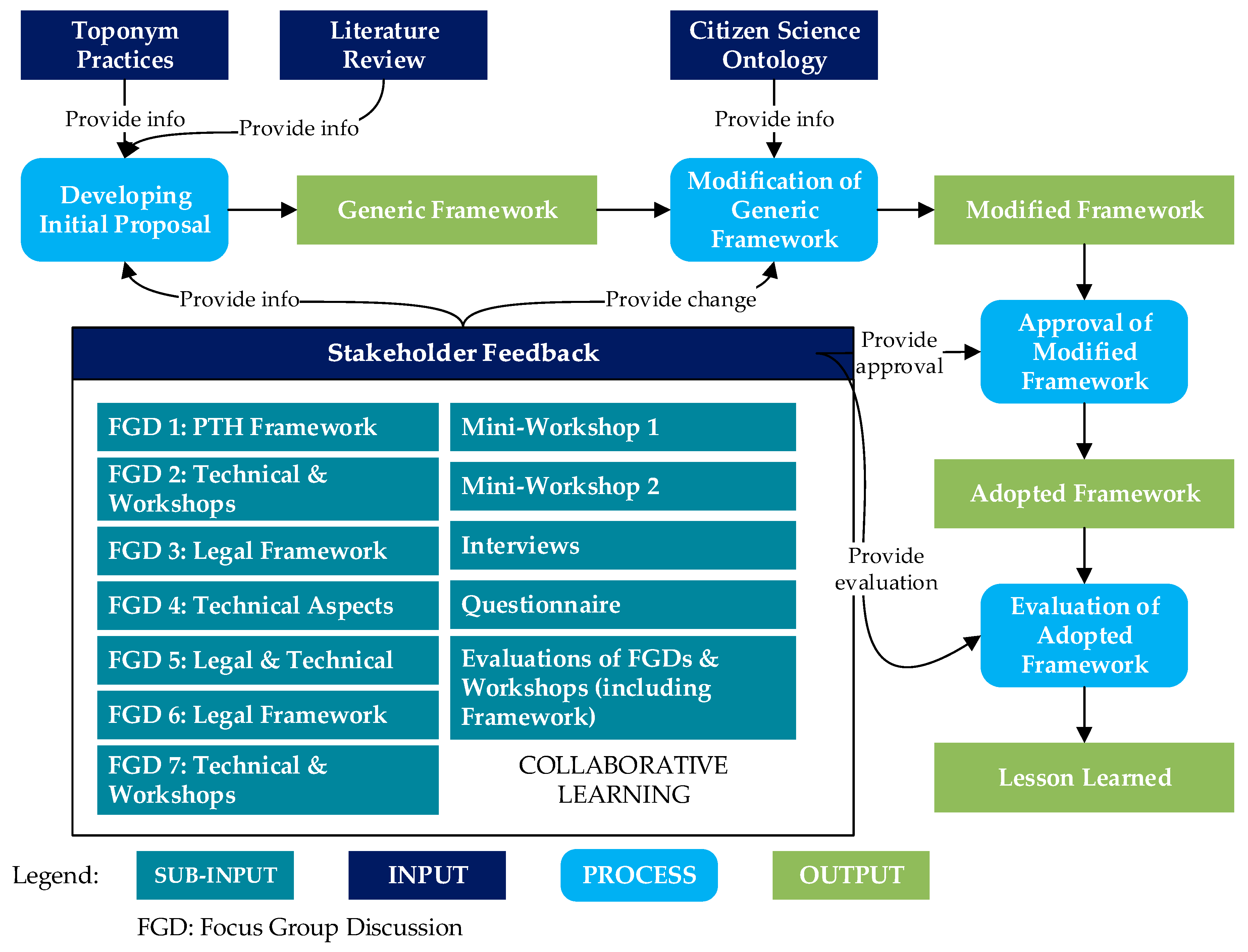
For this project, we used a research workflow to describe the development process of the PTH framework through collaborative learning (see Figure 1). The focus of this workflow is collaborative learning, which enables stakeholders to apply and share their knowledge about toponym handling.
We first investigated several relevant resources on toponymic guidelines, citizen science, VGI, and crowdsourcing. We combined parts of a citizen science ontology developed by a COST Action (https://cs-eu.net/wgs/wg5) [22] to modify the framework. Then, we improved the framework using existing knowledge and feedback from multiple stakeholders. Changes requested by stakeholders were made in an iterative process. When a new change request was made, the modification was approved or rejected after several discussions.
We employed gamification to stimulate participation and fuzzy cognitive mapping [30,31] to bridge the knowledge gaps between stakeholders. These methods were used to boost stakeholder interactivity in FGDs and workshops. We used two game elements (achievements and rewards) to encourage citizens to discuss or give feedback on specific issues and to suggest ideas for toponym handling projects. Each contribution to the discussion of a participatory toponym handling project earned a point, and badges were awarded. We provided rewards during the workshops and FGDs, and after the assessment was completed. The rewards included gifts (mugs, key chains, magnets), toponym books, and certificates. The strategy was to engage different stakeholders, build collaboration, and gain knowledge. The fuzzy cognitive mapping employed by stakeholders in the FGDs depicts the relationships between elements of toponym handling.
The scope of the FGDs ranged from technical to legal aspects of volunteer and scientific information on toponyms. The workshops enabled stakeholders to discuss and implement the modified framework. The workshops on technical aspects examined the exploration, adoption, and implementation of the plan for participatory toponym handling. A toponym handling system that used a mobile application for toponym collection also was discussed and introduced in the workshops. It is called SAKTI (http://sakti.big.go.id/sakti/webgis/) (Sistem Akusisi Data Toponim Indonesia/Indonesian Toponymic Data Acquisition System), and it was developed by BIG. The mini-workshops were conducted to manage and monitor progress and identify levels of engagement. In the workshops on legal drafting, we discussed and reviewed UNGEGN recommendations, best practices from other countries, and regulations in Indonesia related to toponyms. Recommended texts on the definition of toponyms and about technical issues was ere elaborated and promoted to be translated into a legal document.
In addition, we interviewed personnel involved in toponym practice, and we administered a questionnaire to relevant stakeholders and key actors. In the evaluation step, we identified the training conducted by the Indonesian NNA in 2018 as the baseline for the learning process and knowledge sharing mechanism. Then, we compared it with the feedback from the workshops and recommendations from interviews with participants.
4. Results
4.1. Fuzzy Cognitive Map and a Generic PTH Framework
During the FGDs, a fuzzy cognitive map was generated to illustrate the workflow and problems in toponym handling. The elements in this mind map and connections between elements were then incorporated into the PTH framework through discussions on essential toponymic content such as the meanings and interpretations of place names. To increase citizen involvement, Organization must be addressed as the focal point for problems in Indonesia’s toponyms practice.
Figure 2 shows a fuzzy cognitive map of (participatory) toponym handling as one of the outcomes of the discussions about organizational challenges (represented in red lines) and opportunities in toponym handling (represented in blue line: support and black line: regular relationship). Most participants strongly recommended the integration of knowledge sharing and participatory approaches. This could be achieved through policy change and capacity building for multiple stakeholders. Such efforts increase collaboration between academics, local government, NGOs or the private sector, and members of the public. Challenges facing current toponymic practices in Indonesia cut across financing, human resource needs, standardization, and policy.
A framework for PTH was developed through several steps shown in the workflow (Figure 1). The participatory approach is relatively new in toponym handling. In this case, we start learning from the existing workflow of VGI and citizen science or crowdsourcing as the lowest level of citizen science (according to Haklay’s typology of participation [14]. Currently, local governments are actively involved in toponym handling, and they sometimes involve university students to explore participation through crowdsourcing in toponymic surveys [32]. Based on these background situations, our initial proposal for a generic framework for PTH included three processes: Traditional survey, citizen participation, and toponymic CGI or VGI.
In the initial proposal, we focused on how toponym handling could help provide an enriched toponymic file and gazetteer. The initial generic framework on handling toponyms using a participatory approach was introduced and modified after several discussions. During these processes, stakeholders shared their knowledge and information on handling toponyms. In the modified framework (see Figure 3), we then changed the focus from data-oriented problems to toponym handling as a project-based approach. In the modified framework, we define eight classes: Stakeholder, Actor, Role, Project, Task, Toolkit, Method, and Dataset. The types of toponym handling in a proposed generic framework are covered in Method. Some categories in that framework were adopted from Citizen Science Ontology [22], for example, elements in Role class and Project class.
4.2. Testing Participatory Approach and Exploring Stakeholder Involvement.
There is a traditional concept of mutual assistance in Indonesia, known as gotong-royong [33]. A participatory approach is very similar to it. By testing or adopting the PTH framework, new information was generated through collaborative learning, which led to the adjustment of the generic framework into an actual condition in the Indonesian case study. We adapt the PTH framework in a concrete implementation on a regional case study in Yogyakarta through iteration of collaborative learning. Collaborative learning in the workshops and FGDs was achieved by citizen toponymists, researchers, and the government by cooperation in identifying, deciding and developing the toolkit for toponymic surveys. This includes both the development of mobile and web applications and the building of supportive project sustainability.
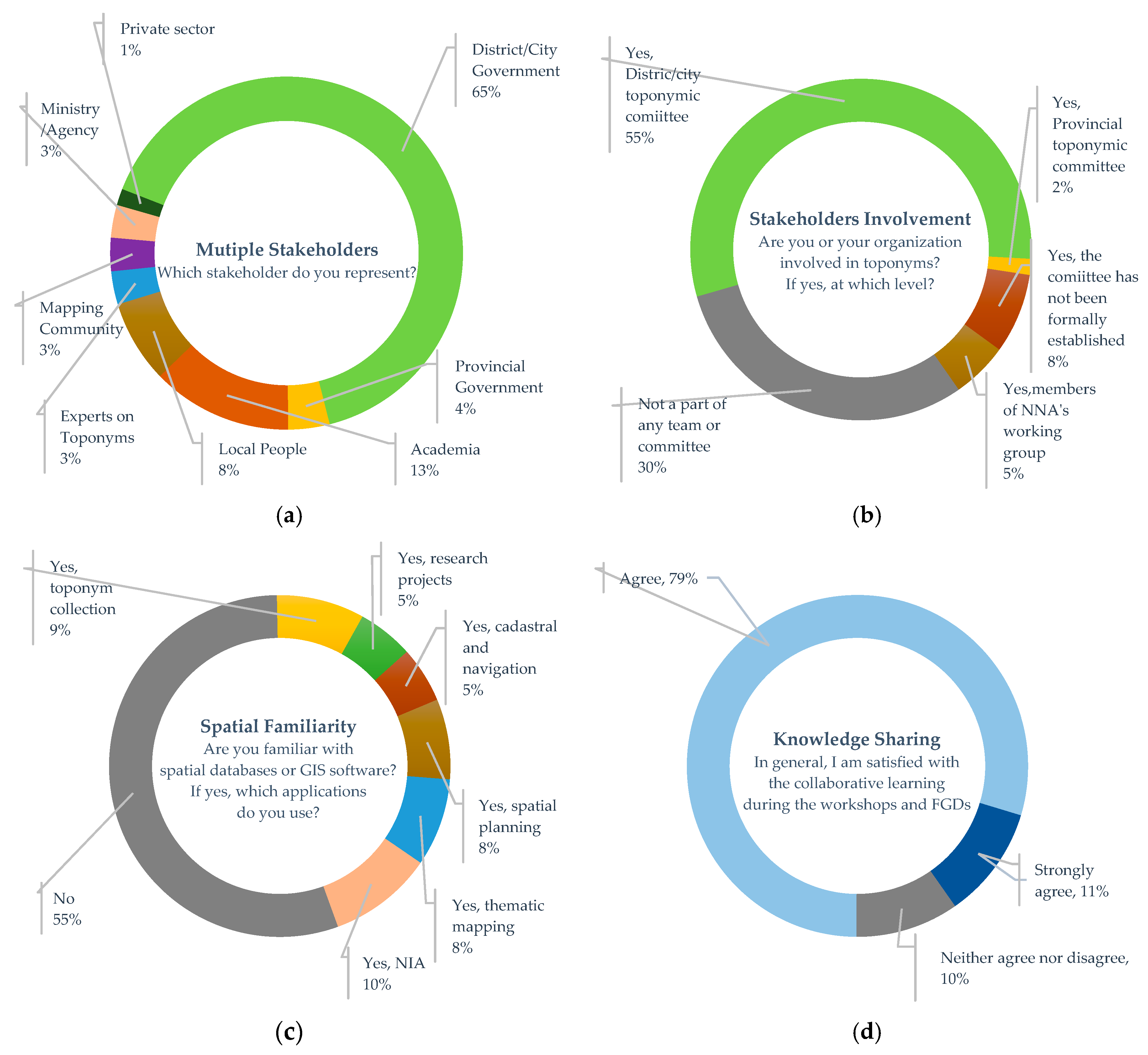
The questionnaires and interviews were conducted during June and July 2019, and we received feedback from 132 respondents and interviewees (a total of 150 participants in workshops and FGDs). The questionnaire was categorized into five groups. The first set of questions aimed at defining context and stakeholder groups. The second set explored the current organizational focus and involvement on toponyms. The third set examined the participant’s preparation for the workshop and spatial literacy. The fourth group was intended to evaluate content and facilitation for the workshops. Finally, the fifth group explored basic knowledge on toponymy, personal appraisal, and viewpoint, including questions of voluntary participation in toponym handling. Some questions might not apply to all stakeholder groups.
The citizens who participated in the workshops opted for interviews instead of a questionnaire. In the interviews, we asked the same questions as in the questionnaires, but we allowed deviations to remain flexible in collecting information and establishing a connection with citizens. The interviews worked on exploring their fundamental knowledge about toponyms, their perspectives on current toponymic activities, and the prospect of inviting them to join toponyms data collection using the participatory toponymic approach. During the interview, two examples of questions arose: “In your words, what are the toponym collection problems we should be trying to solve? What would be your contribution to a participatory toponym handling project?”
There were four lists of questions on stakeholders’ background, involvement, and willingness to share knowledge during PTH development and framework testing. Figure 4a shows the percentages of stakeholders interested in PTH and in participating. Some members of the public (8%) were willing to play an active role in participatory toponym handling projects. Figure 4b shows stakeholder participation in current toponyms practice. Most of the participants in the workshops and FGDs were from local committees at the district/city level and provincial level. However, thirty percent of respondents were not part of any toponym collection team or committee in Indonesia. Figure 4c indicates spatial familiarity. More than half of the participants in the workshops were not familiar with spatial data. This information allowed us to provide a better introduction to toponyms as part of geographic data collection using mobile and web applications.
In general, participants involved in the development and evaluation of the PTH framework were satisfied with knowledge sharing through collaborative learning activities (see Figure 4d). They realized and felt their considerations on the importance of place names in their daily lives and how elderly people gave names that had meanings linked to geographical phenomena. This was shown through their help collecting the toponyms for their neighborhood. The private sector was represented by a GIS consultant who works on capacity building of participatory GIS for villages. The workshops offered opportunities for future projects of collaboration. The private sector and one university in Yogyakarta are planning to set up a geospatial capacity building workshop to introduce geo-entrepreneurship and mobile apps for geographic data collection.
Understanding stakeholders and engaging with them can help to develop sustainable projects and promote organizational interoperability. Organizational interoperability focuses on how different stakeholders work together to reach common goals. Humanitarian OSM Indonesia shared its experience in building support for the ecosystem as part of the working environment and got the community to utilize their skills and knowledge.
4.3. Technical and Legal Elements of PTH for Consideration in Indonesia
It is important to consider the technical and legal aspects of any adaptation of a generic framework to a concrete case. As the responsible stakeholder on the national level, the recommendations of the FGDs are that BIG should consider and discuss developing comprehensive policies on how to link and cooperate on toponymic technical, organizational, and regulatory problems. In addition, BIG should continue outreach efforts to promote campaigns on toponymy and cooperate with the community such as Google Local Guide, Facebook Place Editor, OSM community, and local NGOs. Meanwhile, to motivate contributors, they might provide a certificate as a reward for the contributor’s efforts in collecting toponyms.
BIG and other stakeholders in workshops on technical and legal issues are working together to address existing practices with Indonesian toponyms. Legal problems on toponyms in Indonesia began with the change from the previous organizational setting to BIG’s responsibility as NNA. This resulted in a dualism of parallel regulations on toponym handling.
The legal aspect guides how to use crowdsourced geographic information (from global gazetteer, OSM, and many other sources, including local place names information from local participatory mapping activity) for completing and enriching the national gazetteer. NNAs should consider synchronization of existing toponyms with other potential sources (toponymic CGI, such as global gazetteer Geonames and OSM dataset). During the process of drafting legal documents, we realized that there is a need to evaluate the protocols and existing SOPs established by BIG or other agencies. Despite this, there is still no SOP or regulation on participatory toponym handling.
To deal with the verification and integration of multiple sources of toponymic files and gazetteers, we adopted criteria from three sources: the gazetteer quality criteria developed by Hill [34], the A4C4 quality requirements by Swisstopo [35], and the data quality requirements of Indonesian topographic base maps [36], especially for attribute accuracy for toponyms. Gazetteer quality criteria from Hill [34] were previously used to compare global gazetteers (Geonames and TGN) with gazetteers produced by mapping agencies from Ordnance Survey 50K and SwissNames 3D [37]. In addition, the stakeholders chose two quality criteria (Swisstopo and BIG) because they are fit to assess the mapping agency’s gazetteer.
Table 1 shows the criteria for verification that stakeholders proposed during discussions in FGD 5 to FGD 7. The criteria and descriptions were modified from [34,35,36]. These criteria can be used by BIG to check and assess the toponymic data quality before the integration of crowdsourced toponym files. Appendix A shows the details in Table A1 complete with measuring units. Each criterion involves qualitative and quantitative considerations based on discussion sessions on implementing and testing PTH. These criteria must be reviewed again by multiple stakeholders before carrying out verification tests. Measurement results will be stored in metadata of toponymic files and gazetteer. Together, the toponymic dataset and other relevant information will be used to continue with the next verification steps with a group of experts on toponyms.
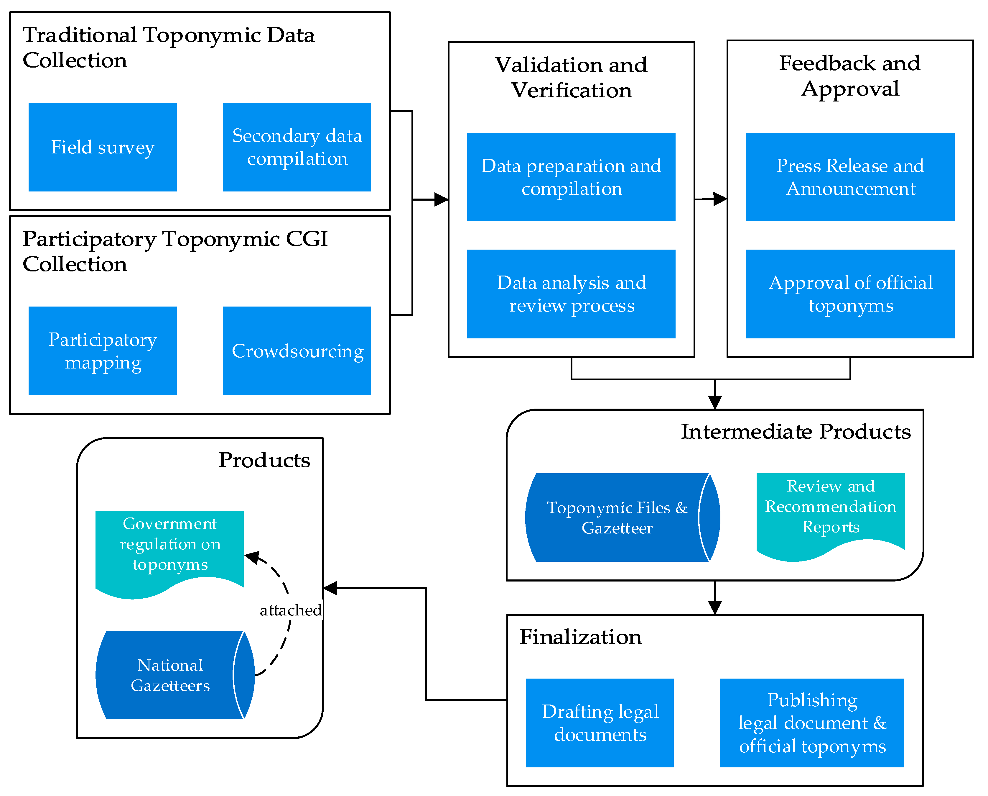
Another output from the workshops and FGDs on technical and legal aspects (FGD 3 to FGD 7) is a draft of a new government regulation. It was established through high-level discussions led by BIG and supported by the Faculty of Law, Universitas Gadjah Mada, Indonesia. The draft proposal for the new regulation on toponyms includes four recognized approaches to collecting toponyms (Figure 5).
A field survey is the traditional way that national agencies and local committees collect toponyms. Secondary data compilation is the collection of toponymic information from government or non-governmental organizations, published or unpublished. This method supports the field surveys and provides additional details and links to toponyms. There are two novel approaches in the draft of the new regulation on toponyms in Indonesia: participatory mapping and crowdsourcing. This regulation defines participatory mapping as activities to collect toponym data by involving community groups or organizations. In contrast, crowdsourcing is defined as toponym collection that involves citizens, especially individuals, where data are stored in the organizer’s database. These two approaches allow a local government to encourage multiple stakeholders to be more active in toponym handling, specifically enabling citizen toponymists. A simple step to enable citizens to become toponymists is to ask people to help to preserve toponyms surrounding their neighborhood.
5. Discussion
Developing a generic framework and modifying it through collaborative learning must be a robust process to ensure that the generic framework can be adapted for different settings. Examples of citizen participation in geographic data collection (sometimes related to toponyms) have often been studied by researchers outside of the UNGEGN members. This includes toolkit development (gamified mobile apps for collecting points of interest, landmarks, or toponyms) in relation to specific themes. Discussion of citizen participation in the official toponymic workflow has been ongoing since a UNGEGN meeting in 2012. At that time, government officials and researchers (members of UNGEGN) shared their lessons learned. They tried to enable local governments or other related actors to collect toponyms voluntarily. This was a definite improvement, but it still lacked active involvement from citizens as toponymists. Any NNA or other associated organization needs a generic framework of PTH to be included in its current toponymic workflow.
The initial proposal for a generic framework focused on different approaches to enable citizen participation in official workflows of toponym collection. Participants in the discussions and modifications of the generic framework recommended having a participatory toponym handling as a project. Furthermore, a Citizen Science Ontology (developed by Working Group 5—Improve data standardization and interoperability of Citizen Science COST Action [22]) provided a foundation to establish or modify the initial generic framework into a more implementable workflow.
Streamlining the workflow of toponym handling needs common goals and agreements among stakeholders. Different perspectives, tasks, interests, and purposes also trigger new challenges in building and harmonizing participatory toponym handling. Several meetings are required to delineate a common understanding of the different roles played by multiple stakeholders before a mutually approved outcome can be achieved. This common understanding can help to address certain problems. For example, where there are limited human resources for collecting toponyms, lecturers and students from an academic institution, who volunteer as part of their community service program, can support the local committee on toponyms in conducting a toponymic field survey. They may provide training to establish participatory toponym handling or work together with society. This kind of participatory approach is flexible enough to be implemented in Indonesia as long as it is supported with reliable information on handling toponyms. A pilot project showed that the participatory dataset could enrich toponymic information and include areas not covered by toponyms from the government.
Dealing with classical problems of toponym collection by the government (e.g., lack of human resources and budget limitation), academics and community members proposed a concrete action plan on how to involve citizens as toponymists—for example, student internships or fieldwork that connects academic study and community service practice. This concept remains a challenge because cooperation between academics, local authorities, and people is necessary. Moreover, it depends on every region’s character and nature to encourage and involve the citizen. The modified framework can be adopted and modified according to the characteristics of each country or region. In addition, local conditions also help the implementation of this type of project. It would be useful to understand local characteristics before implementing this type of toponym handling project and to engage with multiple stakeholders.
On the other hand, the strategy of collaborative learning and knowledge sharing inspired BIG to develop their action plans. The involvement of multiple stakeholders on sessions concerning technical and legal concerns and the implementation of toponyms from multiple perspectives is going to be adopted in upcoming technical assistance to the local committee. An action plan to enable public participation in handling toponyms is being discussed by NNA in Indonesia. The adoption of participatory toponym handling is represented in the new Indonesian draft of a government regulation on toponyms. Regarding the two citizen-based approaches to collect toponyms, there is a need for research on the incentives and disincentives for toponym handling, and how organizers can actively engage citizens. Data collected or contributed by the citizens will be maintained as a citizen layer to be verified and integrated into official toponymic files and gazetteers. The future work is to develop toponymic guidelines or procedures by detailing technical steps of the toponymic workflow as proposed in the draft government regulation. Meanwhile, NNA is continuously working on high-level discussions with multiple ministries involved in reviewing the draft of toponymic regulation.
One suggestion from stakeholders is that training and education still need to leverage contributors for handling toponyms, either by the participatory or by the traditional approach. Each stakeholder recognizes their role in handling toponyms and offers their potential support to conduct or establish co-created or collaborative toponymic field survey projects. Local people learned directly from a group of experts on toponyms about toponymic diagnosing and the meaning of place names. The experts also realized their roles in promoting toponyms to the community by collaborating with local government. However, the intensity of meetings between multiple stakeholders in workshops or FGDs and the inclusion of citizen toponymists in toponymic collection projects should be considered to cover working areas, and the toolkit for toponym collection may help to improve the process of participatory toponyms. Nevertheless, the participatory approach demonstrated that citizen toponymists can provide toponymic data with voice recordings, photos, and other relevant information.
6. Conclusions
A long journey of sharing knowledge and collaborative learning on toponyms by multiple stakeholders provided meaningful feedback to improve and modify the framework. The results revitalized the relationship between them and should be maintained by the NNA in Indonesia. The next steps are to implement the framework through toponymic survey projects and promoting the roles of citizen toponymists in participatory toponym handling. Embedded knowledge on toponyms maintained in toponymic files and gazetteers and toponymy itself should be part of open science where a citizen could share and learn about toponyms in their neighborhood and other regions.
From this research, it can be concluded that establishing participatory toponym handling in Indonesia requires a collaborative approach and openness from multiple stakeholders. The case study of the participatory approach in Yogyakarta has shown that the generic framework can be implemented in concrete situations. The spirit of gotong-royong would be a valuable factor for enabling Indonesia’s citizen toponymists and for conducting collaborative learning as part of geospatial capacity building on toponyms. One achievement is that the national government agreed to include citizen participation (participatory mapping and crowdsourcing) in the new draft of the toponymic legal framework. Concrete action plans still need to be established and initiated by NNA.
The limitation on funding and human resources becomes the primary concern in several regions due to the minimum understanding by multiple stakeholders at the regional, provincial, city/district, and sub-district levels. In this case, Indonesian NNA should provide the national program on toponyms as an umbrella for local governments and guidance to manage their budgeting and human resource allocation. Continued communication through toponymic training and education can leverage and sustain public participation in toponym preservation as part of their daily communication and activities. Toponymic guidelines should be published or provided through local committees until the lowest level of administrative areas are publicly available on the website or other platforms.
Different perspectives, backgrounds, characteristics, and motivations of citizens to participate as toponymists in participatory toponym handling remain one of the issues to be discussed. Knowledge sharing and collaborative learning through comprehensive information on technical and legal aspects encourage people to contribute or be involved in toponym collection and preservation. Finally, the NNA should consider how to handle toponymic files (including crowdsourced and volunteered geographic information) in their technical workflow and national program. Multiple stakeholders involved in toponym handling are ready to enable citizen-based approaches and optimize existing toolkits and methods.
Author Contributions
A.P.P. and F.O.O. discussed the idea; A.P.P. undertook the field work and analyses; A.P.P. and F.O.O. both contributed to the writing of this manuscript.
Funding
The authors would like to acknowledge financial support provided by Indonesia Endowment Fund for Education (LPDP), within code of LPDP: PRJ-2569/LPDP/2015 provided to Aji Putra Perdana, Faculty of Geo-Information Science and Earth Observation (ITC), University of Twente for his Ph.D. research funding.
Acknowledgments
The first author would like to thank the Ministry of Finance for the Republic of Indonesia’s Indonesian Endowment Fund for Education (LPDP) for supporting his Ph.D. research. This work is supported by Badan Informasi Geospasial (BIG) as National Naming Authority of Indonesia. The authors would like to thank the anonymous reviewers for their valuable comments and suggestions.
Conflicts of Interest
The authors declare no conflict of interest. The founding sponsors had no role in the design of the study; in the collection, analyses, or interpretation of data; in the writing of the manuscript, and in the decision to publish the results.
Appendix A. Verification Criteria for Toponymic Files and Gazetteer
Table A1 describes the criteria, descriptions, and measurement units for verifying toponymic files and gazetteer.

Table A1.
Details of verification criteria for toponymic files and gazetteer.
| Criterion | Description | Measurement Unit |
|---|---|---|
| Authority | Data source, production | Various sources, experts, field survey, mapping agency, NNA, or other authorities. Authorization status: 1: verified by authoritative agencies/experts 0: not verified yet |
| Accuracy | Number of detectable errors in names, footprints, and feature types | Calculated in percentage (%) by comparing detectable errors toponymic features to total data collection. |
| Availability | The degree to which the toponymic files and gazetteers are freely available and not limited by restrictive conditions of use (data access) | Information on details of data accessibility (e.g., types of data license) Degree of availability: 0: Restricted or limited access 1: Free 2: downloadable 3: Online access |
| Actuality | Date of data specific survey; the degree to which the toponymic files and gazetteer have incorporated changes | Date of survey (data collection timestamp) and date of changes (last update information) |
| Completeness | Steered by toponymic surveying rules; the degree to which the scope of toponymic files and gazetteers are covered completely | Cannot be calculated (?), calculated based on administrative area coverage (✓) or other boundaries (such as research boundaries) – calculated in percentage (%) |
| Scope /Coverage | Small communal database, regional/national coverage, or worldwide coverage | Worldwide, national (country name), regional (province name), local (district, sub-district), small communal (village or neighborhood), specific area (study/research area) |
| Consistency | Data consistency and coherence | Calculated in percentage (%) by comparing inconsistent data to total data collection. 1: Consistent - If all the database value is registered following the structure of the toponym files and toponymic writing rules. 0: Inconsistent – If there is any information not following the rules. |
| Richness of annotation | Amount and detail of descriptive information, beyond the basics of name, footprint, and feature type | Qualitative approach based on toponymic content richness. Complete information may include pictures and voice recording (High), place names and feature types or footprint information (Medium), limited to place names information only (Low). |
| Granularity | Whether data includes large, well-known features only or features of all sizes and those that are less well known | 1: Very coarse—only specific large toponym with minimum information distributed 2: Coarse—large features only 3: Medium – well-known features only or feature of all sizes 4: Fine—covered all types of features and those that are less well known |
| Balance | Uniform degree of detail, currency, accuracy, and granularity across scope of coverage | 0: Cannot be calculated (?) 1: Balance in across coverage area (Uniform) |
References
- Kerfoot, H.; Närhi, E. Manual for the National Standardization of Geographical Names; United Nations Publication: New York, NY, USA, 2006; ISBN 92-1-161490-2. [Google Scholar]
- Zaccheddu, P. The UNGEGN Advanced Toponymy Manual. In Proceedings of the 11th United Nations Conference on the Standardization of Geographical Names (UNCSGN), New York, NY, USA, 8–17 August 2017. [Google Scholar]
- Hogerwerf, J. Toponymic data and map production in the Netherlands: From field work to crowd sourcing. In Proceedings of the 11th United Nations Conference on the Standardization of Geographical Names (UNCSGN), New York, NY, USA, 8–17 August 2017. [Google Scholar]
- Touya, G.; Antoniou, V.; Olteanu-Raimond, A.-M.; Van Damme, M.-D. Assessing Crowdsourced POI Quality: Combining Methods Based on Reference Data, History, and Spatial Relations. ISPRS Int. J. Geo-Inf. 2017, 6, 80. [Google Scholar] [CrossRef]
- Zhu, R.; Hu, Y.; Janowicz, K.; McKenzie, G. Spatial signatures for geographic feature types: Examining gazetteer ontologies using spatial statistics. Trans. GIS 2016, 20, 333–355. [Google Scholar] [CrossRef]
- Laurini, R. Gazetteers and Multilingualism. In Geographic Knowledge Infrastructure; Elsevier: New York, NY, USA, 2017; pp. 157–182. ISBN 9781785482434. [Google Scholar]
- Howe, J. The Rise of Crowdsourcing. Wired Mag. 2006, 14, 1–4. [Google Scholar]
- Ahmouda, A.; Hochmair, H.H. Using Volunteered Geographic Information to measure name changes of artificial geographical features as a result of political changes: A Libya case study. GeoJournal 2018, 83, 237–255. [Google Scholar] [CrossRef]
- Rampl, G. Crowdsourcing and GIS-based Methods in a Field Name survey in Tyrol (Austria). In Proceedings of the Twenty-Eight Session on Geographical Names, New York, NY, USA, 28 April–2 May 2014. [Google Scholar]
- Gercsák, G.; Mikesy, G. Does Google serve as a model for using place names? Acta Geogr. Slov. 2017, 57, 153–159. [Google Scholar] [CrossRef]
- Moeller, M.S.; Furhmann, S. Mapping the World—A New Approach for Volunteered Geographic Information in the Cloud. ISPRS Int. Arch. Photogramm. Remote Sens. Spat. Inf. Sci. 2015, XL-6/W1, 9–10. [Google Scholar] [CrossRef]
- Bonney, R.; Cooper, C.B.; Dickinson, J.; Kelling, S.; Phillips, T.; Rosenberg, K.V.; Shirk, J. Citizen science: A developing tool for expanding science knowledge and scientific literacy. BioScience 2009, 59, 977–984. [Google Scholar] [CrossRef]
- Serrano Sanz, F.; Holocher-Ertl, T.; Kieslinger, B.; Sanz Garcıa, F.; Silva, C. White Paper on Citizen Science for Europe; Socientize Consortium: European Commission: Brussels, Belgium, 2014. [Google Scholar]
- Haklay, M. Citizen Science and Volunteered Geographic Information—Overview and typology of particpation. In Crowdsourcing Geographic Knowledge: Volunteered Geographic Information (VGI) in Theory and Practice; Springer: Dordrecht, The Netherlands, 2013; pp. 105–122. ISBN 978-94-007-4586-5. [Google Scholar]
- UNGEGN. UNGEGN—Toponymic Guidelines for Map and Other Editors. Available online: https://unstats.un.org/UNSD/geoinfo/UNGEGN/toponymic.html (accessed on 17 May 2018).
- Castellote, J.; Huerta Guijarro, J.; Pescador, J.; Brown, M. Towns Conquer: A Gamified application to collect geographical names (vernacular names/toponyms). In Proceedings of the The 16th AGILE International Conference on Geographic Information Science, Leuven, Belgium, 14–17 May 2013. [Google Scholar]
- Southall, H.; Aucott, P.; Fleet, C.; Pert, T.; Stoner, M. GB1900: Engaging the Public in Very Large Scale Gazetteer Construction from the Ordnance Survey “County Series” 1:10,560 Mapping of Great Britain. J. Map Geogr. Libr. 2017, 13, 7–28. [Google Scholar] [CrossRef]
- Jones, C.B.; Purves, R.S.; Clough, P.D.; Joho, H. Modelling Vague Regions with Knowledge From the Web. Int. J. Geogr. Inf. Sci. 2008, 22, 1045–1065. [Google Scholar] [CrossRef]
- Vasardani, M.; Winter, S.; Richter, K.F. Locating place names from place descriptions. Int. J. Geogr. Inf. Sci. 2013, 27, 2509–2532. [Google Scholar] [CrossRef]
- Camponovo, M.E.; Freundschuh, S.M. Assessing uncertainty in VGI for emergency response. Cartogr. Geogr. Inf. Sci. 2014, 41, 440–455. [Google Scholar] [CrossRef]
- Kim, J.; Vasardani, M.; Winter, S. Similarity matching for integrating spatial information extracted from textual descriptions. Int. J. Geogr. Inf. Sci. 2017, 31, 56–80. [Google Scholar] [CrossRef]
- Ceccaroni, L.; Schade, S.; Bastin, L.; Tsinaraki, C.; Lemmens, R.; Falquet, G.; Klan, F.; Piera, J.; Trojan, J.; Lendak, I.; et al. WG5-Deliverable 1: Citizen-Science Ontology; European Cooperation in Science Technology: Brussels, Belgium, 2018. [Google Scholar]
- McCartney, E.A.; Craun, K.J.; Korris, E.; Brostuen, D.A.; Moore, L.R. Crowdsourcing the National Map. Cartogr. Geogr. Inf. Sci. 2015, 42, 54–57. [Google Scholar] [CrossRef]
- Rönneberg, M.; Laakso, M.; Sarjakoski, T. Map Gretel: Social map service supporting a national mapping gency in data collection. J. Geogr. Syst. 2019, 21, 43–59. [Google Scholar] [CrossRef]
- Zimmermann, A.; Oshri, I.; Lioliou, E.; Gerbasi, A. Sourcing in or out: Implications for social capital and knowledge sharing. J. Strateg. Inf. Syst. 2018, 27, 82–100. [Google Scholar] [CrossRef]
- Alem, L.; Mclean, A.; Vercoustre, A. Knowledge sharing technologies to support community participation in natural resource management: A Research Agenda. In Proceedings of the Australian Conference for Knowledge Management & Intelligent Decision Support, Melbourne, Australia, 3 December 2003. [Google Scholar]
- Teodoro, M.F.; Correia, A.; Nunes, P. Knowledge management in geospatial information context. A preliminary statistical approach—A case study. WSEAS Trans. Bus. Econ. 2017, 14, 74–80, ISSN 11099526. [Google Scholar]
- Haradhan, M. Sharing of Tacit Knowledge in Organizations: A Review. Am. J. Comput. Sci. Eng. 2016, 3, 6–19. [Google Scholar]
- Ngah, R.; Ibrahim, A.R. Tacit knowledge sharing and organizational performance: Malaysian SMEs perspective. 2007, 276–281. [Google Scholar] [CrossRef]
- Gray, S.; Mellor, D.; Jordan, R.; Crall, A.; Newman, G. Modeling with citizen scientists: Using community-based modeling tools to develop citizen science projects. In Proceedings of the 7th International Congress on Environmental Modelling and Software (iEMSs), San Diego, CA, USA, 15–19 June 2014. [Google Scholar]
- Gray, S.A.; Gray, S.; de Kok, J.L.; Helfgott, A.E.R.; O’Dwyer, B.; Jordan, R.; Nyaki, A. Using fuzzy cognitive mapping as a participatory approach to analyze change, preferred states, and perceived resilience of social-ecological systems. Ecol. Soc. 2015, 20, 11. [Google Scholar] [CrossRef]
- Perdana, A.; Ostermann, F. A Citizen Science Approach for Collecting Toponyms. ISPRS Int. J. Geo-Inf. 2018, 7, 222. [Google Scholar] [CrossRef]
- Bowen, J.R. On the Political Construction of Tradition: Gotong Royong in Indonesia. J. Asian Stud. 1986, 45, 545–561. [Google Scholar] [CrossRef]
- Hill, L.L. Georeferencing: The Geographic Associations of Information; MIT Press: Cambridge, MA, USA, 2006; ISBN 9780262083546. [Google Scholar]
- Crowdsourcing in National Mapping 2017—An International Workshop. Available online: http://www.cs.nuim.ie/~pmooney/eurosdr2017/ (accessed on 17 May 2018).
- Badan Informasi Geospasial. Peraturan Kepala Badan Informasi Geospasial: No 15 Tahun 2014 Tentang Pedoman Teknis Ketelitian Peta Dasar; Badan Informasi Geospasial: Cibinong, Indonesia, 2014; (In Bahasa Indonesia). [Google Scholar]
- Acheson, E.; De Sabbata, S.; Purves, R.S. A quantitative analysis of global gazetteers: Patterns of coverage for common feature types. Comput. Environ. Urban Syst. 2017, 64, 309–320. [Google Scholar] [CrossRef] [Green Version]
Figure 1.
Research workflow.

Figure 2.
Fuzzy cognitive map of (participatory) toponyms handling in the Indonesian case study (blue line: support, red line: challenge, black line: regular relationship).
Figure 2.
Fuzzy cognitive map of (participatory) toponyms handling in the Indonesian case study (blue line: support, red line: challenge, black line: regular relationship).
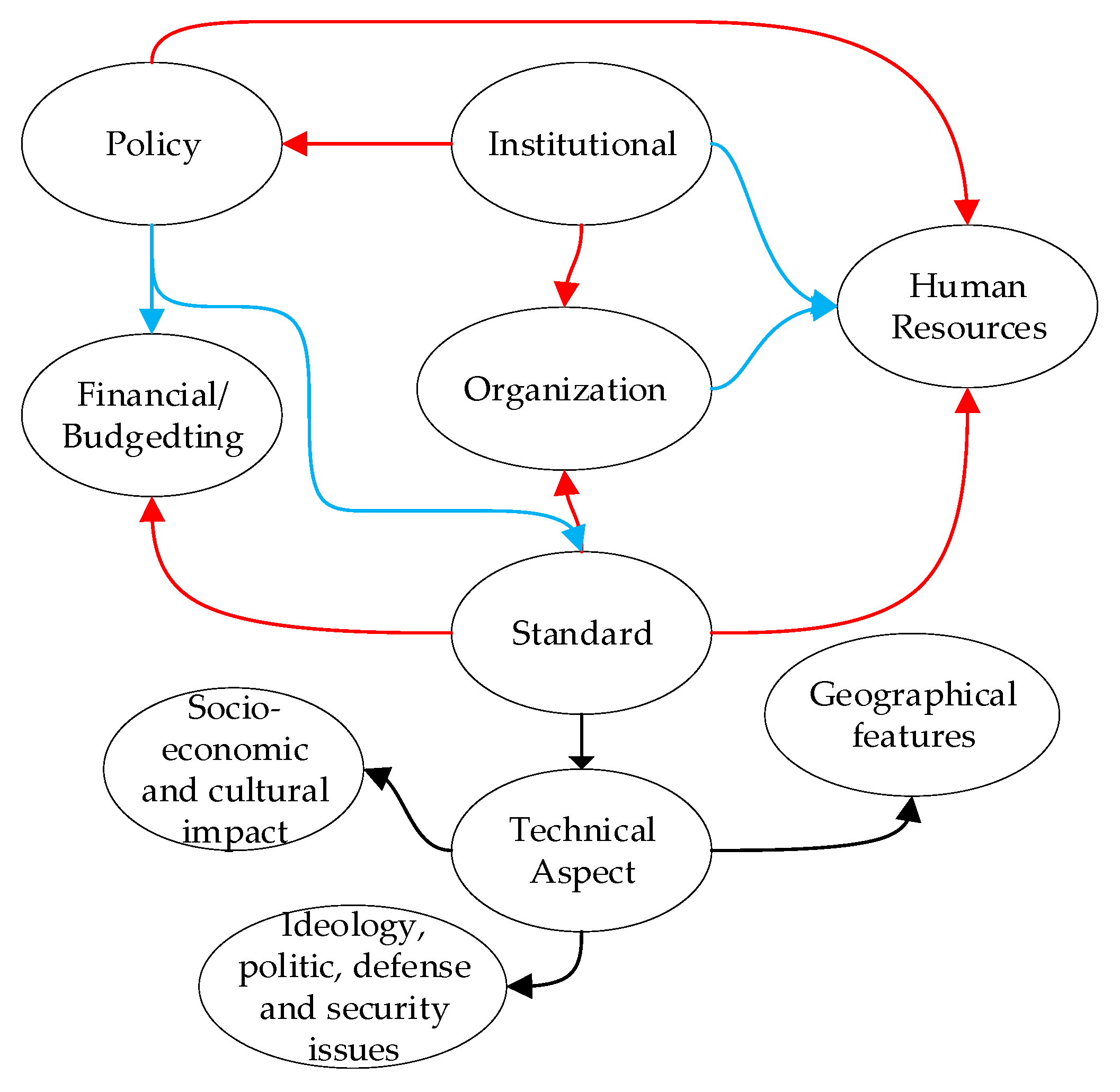
Figure 3.
Modified participatory toponym handling (PTH) framework based on stakeholder feedback and citizen science ontology.
Figure 3.
Modified participatory toponym handling (PTH) framework based on stakeholder feedback and citizen science ontology.
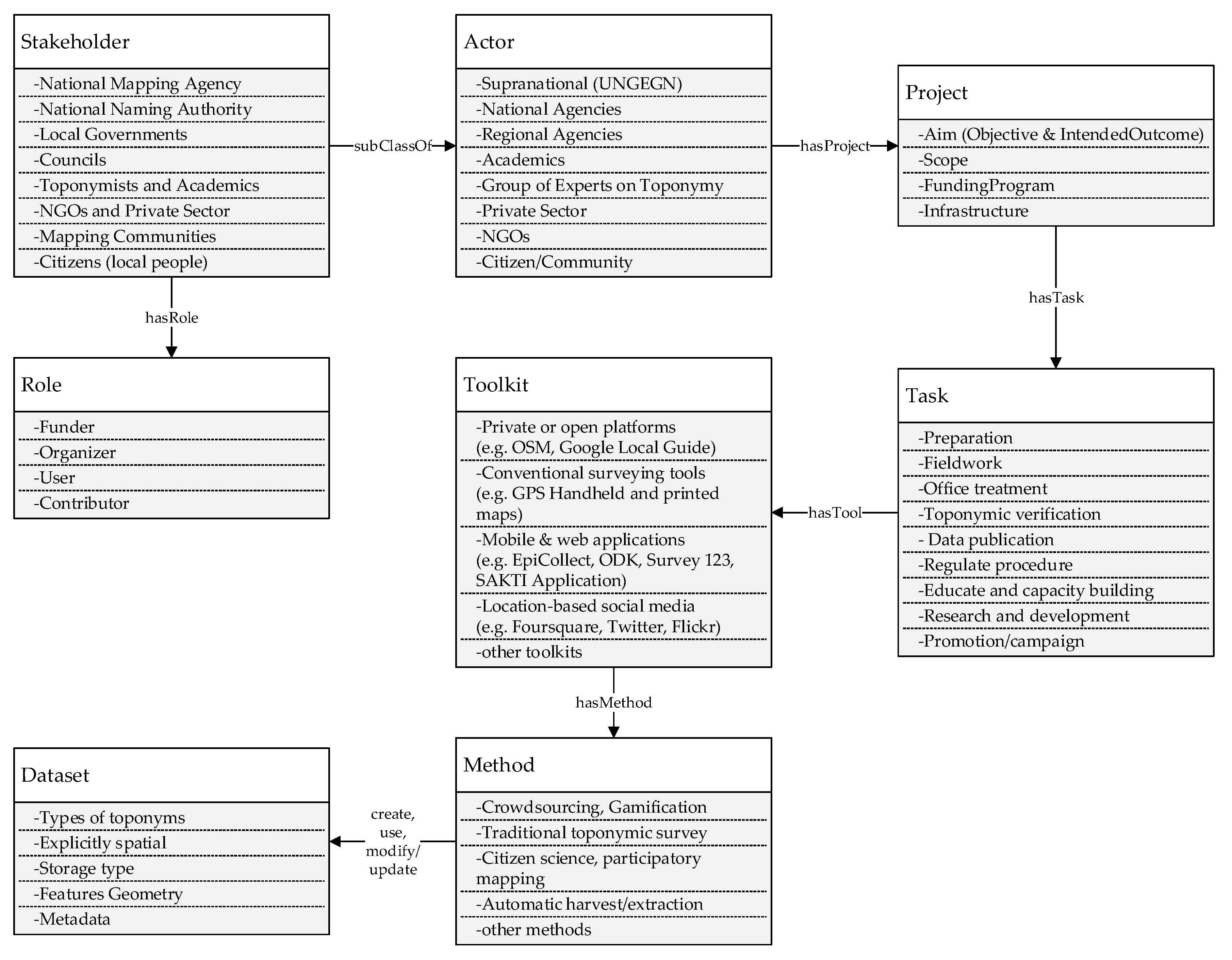
Figure 4.
Multiple stakeholders' background and satisfaction on collaborative learning: (a) type of multiple stakeholders; (b) stakeholders involvement in toponyms; (c) stakeholder familiarity with spatial databases or GIS software; (d) knowledge sharing satisfaction.
Figure 4.
Multiple stakeholders' background and satisfaction on collaborative learning: (a) type of multiple stakeholders; (b) stakeholders involvement in toponyms; (c) stakeholder familiarity with spatial databases or GIS software; (d) knowledge sharing satisfaction.

Figure 5.
Proposal of toponym handling in a draft government regulation on toponyms in Indonesia (modified from BIG, 2019).
Figure 5.
Proposal of toponym handling in a draft government regulation on toponyms in Indonesia (modified from BIG, 2019).

Table 1.
Verification criteria for toponymic files and gazetteer.
| Criterion | Description |
|---|---|
| Authority | Data source, production |
| Accuracy | Number of detectable errors in names, footprints, and feature types |
| Availability | The degree to which the toponymic files and gazetteers are freely available and not limited by restrictive conditions of use (data access) |
| Actuality | Date of data specific survey; the degree to which the toponymic files and gazetteer have incorporated changes |
| Completeness | Steered by toponymic surveying rules; the degree to which the scope of toponymic files and gazetteers are covered completely |
| Scope /Coverage | Small communal database, regional/national coverage, or worldwide coverage |
| Consistency | Data consistency and coherence |
| Richness of annotation | Amount and detail of descriptive information, beyond the basics of name, footprint, and feature type |
| Granularity | Whether data includes large, well-known features only or features of all sizes and those that are less well known |
| Balance | Uniform degree of detail, currency, accuracy, and granularity across scope of coverage |
© 2019 by the authors. Licensee MDPI, Basel, Switzerland. This article is an open access article distributed under the terms and conditions of the Creative Commons Attribution (CC BY) license (http://creativecommons.org/licenses/by/4.0/).
Share and Cite
MDPI and ACS Style
Perdana, A.P.; Ostermann, F.O. Eliciting Knowledge on Technical and Legal Aspects of Participatory Toponym Handling. ISPRS Int. J. Geo-Inf. 2019, 8, 500. https://0-doi-org.brum.beds.ac.uk/10.3390/ijgi8110500
AMA Style
Perdana AP, Ostermann FO. Eliciting Knowledge on Technical and Legal Aspects of Participatory Toponym Handling. ISPRS International Journal of Geo-Information. 2019; 8(11):500. https://0-doi-org.brum.beds.ac.uk/10.3390/ijgi8110500
Chicago/Turabian StylePerdana, Aji Putra, and Frank O. Ostermann. 2019. "Eliciting Knowledge on Technical and Legal Aspects of Participatory Toponym Handling" ISPRS International Journal of Geo-Information 8, no. 11: 500. https://0-doi-org.brum.beds.ac.uk/10.3390/ijgi8110500
Note that from the first issue of 2016, this journal uses article numbers instead of page numbers. See further details here.