1. Introduction
Satellite-based information is currently underutilized for decision-making [
1]. Although some space agencies provide freely available satellite data, barriers remain to its utilization [
2], and the transition from the research to the operational and/or decision-making environment remains a challenge. Moreover, although an increasing number of organizations use satellite data for research purposes and publish in the peer-reviewed literature, research results are not routinely adopted into core decision-making functions within those organizations. In this paper, decision-making refers to decisions needed to carry out activities related to environmental monitoring, forecasting, planning, or risk management. Decision-makers refer to professionals working in organizations engaged in such activities. These organizations span multiple sectors (e.g., government, private) and a vast array of disciplines (e.g., agriculture, air pollution, ecology, emergency management, energy, water quality).
A particular challenge to the decision-making community is access to technical training in utilization of remote-sensing assets. This lack of access to remote-sensing training for working professionals was discussed in the context of conservation [
3,
4,
5], air pollution monitoring [
6], and water resource management [
7]. Many universities worldwide provide courses and training in remote sensing, and many students move on to jobs where they apply these skills professionally. However, not all organizations engaged in decision support have access to a pool of university-trained students, the means to train their staff in an academic environment due to cost or other barriers, or the means to outsource the work to universities.
Working professionals have different training requirements compared to graduate level students or academic researchers. Their time constraints are greater, their technical capacity is frequently lower, and they often face organizational barriers to the adoption of satellite data. In addition, university remote-sensing courses do not always emphasize the link between remote sensing and real-world applications [
8], which can further exacerbate organizational barriers to the adoption of remote-sensing data (RSD) outside of academia. Moreover, the rapidly evolving nature of remote-sensing applications necessitates regular training opportunities for working professionals.
The last decade saw an increase in remote-sensing courses and training in both formal environments such as universities [
9,
10] and open online platforms [
11]. They are offered across the academic, private, and government sectors. Examples of government space agencies offering remote-sensing training include the European Space Agency [
12], the Indian Space Research Organization [
13], and the German Aerospace Center [
14]. Participants of these educational programs are primarily students, and the curriculum is commonly tailored to that audience. Training is also provided through international organizations such as the United Nations Institute for Training and Research (UNITAR), among others.
Remote-sensing training for decision-makers is not as common. Some training programs are uniquely focused on meteorological or climatological applications. Examples include training through the Brazilian National Institute for Space Research [
15], the European Organisation for the Exploitation of Meteorological Satellites (EUMETSAT) training program [
16], the Comet project at the University Corporation for Atmospheric Research (UCAR), sponsored in part by the United States (US) National Oceanic and Atmospheric Administration (NOAA) [
17], and the World Meteorological Organization-Coordination Group for Meteorological Satellites (WMO-CGMS) Virtual Laboratory for Education in Satellite Meteorology [
18]. Other efforts include the joint NASA/US Agency for International Development (USAID) SERVIR [
19] and internally focused training offered through the US Forest Service Geospatial Technology and Applications Center [
20].
2. Methods and Data
2.1. The Applied Remote-Sensing Training (ARSET) Program
ARSET was established in 2008 within NASA’s Applied Sciences Program (ASP) to help bridge the gap between NASA earth science and decision-makers through targeted trainings activities [
21]. It is also a component of the capacity-building program within ASP. ARSET’s main goal is to provide online and in-person training on NASA data access and its application to air quality, disasters, health, land, water, and wildfire management. In 2017, the program added training on monitoring requirements for the United Nations sustainable development goals. In 2018, the program provided 17 trainings for 6362 participants representing 141 countries, 2570 organizations, and 52 US states/territories.
ARSET comprises scientists, students, and consultants. Trainings are led by scientists at NASA centers who are actively engaged in remote-sensing research. ARSET’s instruction intentionally addresses the needs of working professionals. For this reason, the main focus is on making the connection between NASA data and its practical use in support of decision-making. Training participants include air quality forecasters, water reservoir managers, species habitat modelers, and disaster response planners.
All training materials are freely available through the ARSET website [
22]. Trainings are free, except for occasional fees collected by partner organizations hosting in-person trainings. Most written training materials are available in both English and Spanish and, currently, the program delivers two trainings per year in both English and Spanish.
The program provides four levels of training via a combination of lectures in PowerPoint format and hands-on activities. Online trainings are intended both as prerequisites to in-person trainings and as self-contained remote-sensing courses. Trainings on the fundamentals of remote sensing are provided on-demand. Introductory, intermediate, and advanced training is available in-person and via live, online sessions with question and answer periods. Online sessions provide 3–6 h of instruction as a series of live webinars over a period of 2–4 weeks, and frequently include guest speakers. Webinars are also recorded and available through the NASA YouTube channel playlist [
23]. Participants who complete all webinar sessions and homework assignments for an online training receive a certificate of completion.
In-person trainings are 2–4 days in length and are developed in partnership with the organization(s) providing facilities and other resources. This collaboration ensures that the content is tailored to the needs of the prospective participants. ARSET in-person trainings are conducted in the US, Canada, Latin America, India, South Korea, and Southeast Asia.
Introductory training is intended for both technical and non-technical audiences such as program managers. The content includes one or more initial lectures that provide background information on an environmental challenge or management activity, followed by a description of relevant data and how to access it via NASA or external websites. This is followed by examples and/or live demonstrations of specific usage of the data. Most trainings include online homework assignments in a multiple-choice format. The goal of the homework is to test participants’ basic knowledge of the concepts covered in the training.
Intermediate and advanced trainings are intended for participants with greater technical expertise. Compared to introductory training, they are more narrowly focused on building one or more data analysis skills. Both online and in-person trainings begin with lectures on available datasets, including their limitations and uncertainties, and their relevance to one or more environmental management challenges. The rest of the training is dedicated to guiding participants through a step-by-step process on data analysis using open source code or software such as QGIS, Google Earth Engine, R, or a number of NASA analysis tools freely available online. Examples include accessing and deriving vegetation indices from Landsat imagery, deriving surface fine particulate matter concentrations (PM2.5) from satellite aerosol observations, and calculating precipitation anomalies for monitoring flood and drought conditions. These concepts are reinforced with exercises that participants complete on their own during the course of the training. In addition, on the last day of the in-person trainings, participants develop and present to the class a group project that showcases the skills learned in the course for a specific region or event of their choosing.
Program evaluation is an integral component of the ARSET program. Evaluation enables a program to assess progress toward meeting programmatic objectives, to assess the impact of the program, and to apply corrective actions as needed. An external evaluator contracted through the University of Maryland Baltimore County leads ARSET’s evaluation activities. The evaluation includes anonymous surveys and interviews. Surveys are disseminated via online survey software. No personal identifiers are collected and respondents are assured that confidentiality will be maintained.
ARSET uses two independent surveys to collect feedback from participants. An exit survey is disseminated at the conclusion of all trainings. The purpose of this survey is to gather immediate impressions on best practices related to training content and format, to gauge interest in future training topics, and to determine if the training met the learning objectives. The information collected helps instructors refine the training format and content on an ongoing basis so that it is best suited to end-user needs. A separate “post-training survey” is sent to each participant a minimum of six months after each training. The data collected are used to assess progress toward meeting program objectives, and changes in use of RSD by program participants. In this paper, we only discuss self-reported data from the “post-training survey”. The “post-training survey” is currently not linked to the exit survey. The program keeps the two surveys separate in order to maintain confidentially. However, this introduces some limitations to the present study, since it relies on self-reported data. A more precise means to determine changes in learning and data use would necessitate a “pre-training survey” that is linked to a “post-training survey” for each participant. The program is considering a revision to its survey policy by adding a “pre-training survey”.
Surveys were designed using information gathered through previous survey data and interviews with ARSET program participants. Prior to survey launch, several members of the ARSET team and a selection of potential users of NASA data pilot-tested the survey and provided recommendations.
2.2. Participant Demographics
In the following sections, we discuss the results from the 2017 post-training survey sent to individuals who participated in one of 15 online or 14 in-person trainings between 2013 and 2016. A total of 1041 participants of online and in-person trainings submitted responses to the survey, an 18% response rate. Nearly half the respondents had participated in at least one prior ARSET training, and 16% had taken at least three prior trainings.
Air quality training survey respondents had participated in online trainings and multi-day in-person trainings held in the US states of California, Georgia, New York, Texas, and Wyoming, as well as in South Korea. Participants learned about satellite monitoring of trace gases and particulate pollutants.
Disaster training survey respondents had participated in three online trainings focused primarily on flood monitoring applications. Health applications of remote sensing were covered through an online training that provided an overview of health applications for tracking vector borne diseases and algal blooms.
Land application topics were presented during four online trainings. They included use of satellite data for deriving vegetation indices, conservation management, forest cover and change assessment, biodiversity conservation, and coastal and ocean applications. Remote sensing for fire applications were covered during an online webinar series, followed by an in-person training in Idaho.
Three webinars and in person trainings in California, Colombia, and Brazil introduced satellite monitoring and model data relevant to the components of the water cycle (snow, rain, ground water, soil moisture, evapotranspiration) and their use in drought and other hydrological applications. There was also a short course on water quality monitoring.
Figure 1 and
Figure 2 show survey participant demographic data by sector and country. For all data analysis and figures in this paper,
N indicates the number of responses for each survey question. Overall, 61% of survey respondents worked outside of academia, while students and faculty comprised the remaining 39%. This reflects ARSET’s intentional outreach activities toward decision-makers. Government at all levels (municipal, state/provincial, regional, federal/central, and tribal) comprised 40% of participants. The remainder of respondents outside academia (21%) worked in private businesses, non-governmental organizations (NGOs), or multinational organizations (
Figure 1).
Demographic analysis similar to
Figure 1 is used by ARSET to help identify sectors that do not participate in ARSET trainings as frequently, and to direct future outreach activities. For example, ARSET recently increased outreach to municipal organizations, leading to a 30% increase in their participation between 2017 and 2018.
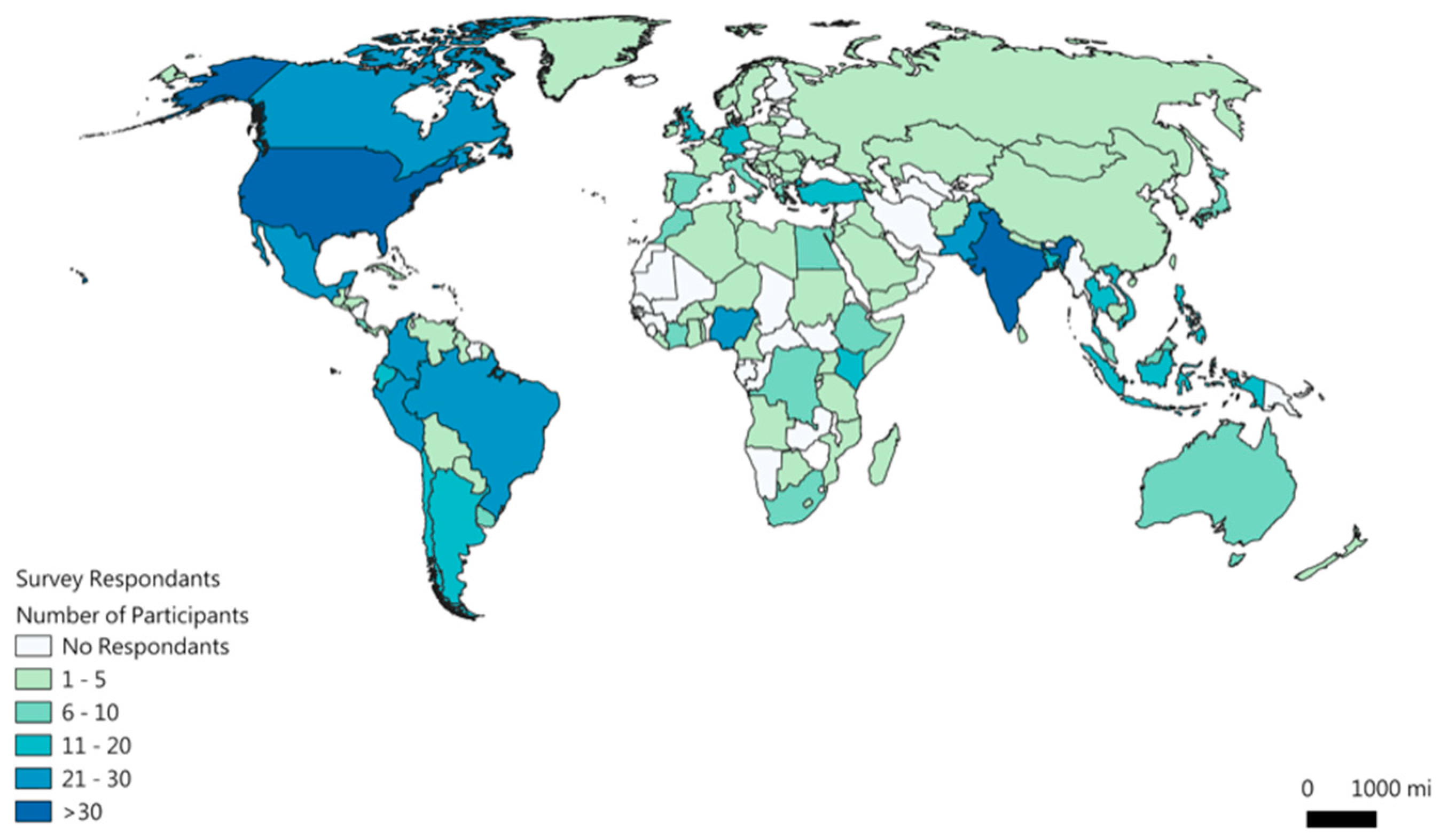
Respondents represented 117 countries (
Figure 2). The number of countries participating in ARSET trainings has been growing steadily since 2008. Contributing factors include increasing recognition of the ARSET name, the provision of certificates of completion, and ARSET communications via social media and the listserv. As of April 2019, ARSET’s Twitter account (@NASAARSET) has more than 6000 followers. The listserv, used to disseminate a quarterly newsletter and information on upcoming trainings, has over 3000 subscribers.
Among survey respondents, nearly 75% work outside the US. The two countries with the greatest number of participants were the US (26%) and India (12%), and there was also substantial participation from Latin America (18%). The geographical distribution is due in part to ARSET’s regionally focused trainings in the US, India, and Spanish-speaking countries. Spanish language training was also a key factor in increasing participation across Latin America.
Respondents also indicated the percentage of their work time spent in eight work categories (
Figure 3). More than two-thirds had work responsibilities in five or more of the work categories, suggesting that training participants manage a very diverse workload. Almost half (47%) of the respondents identified research as a major responsibility. A large percentage of respondents had job responsibilities that are closely associated with decision-making, as defined earlier in the text (see
Section 1). Policy and regulation was a job responsibility for 44% of the participants, 76% were engaged in monitoring and forecasting, and 53% were involved in ecological management. To ensure confidentiality, we did not collect information regarding specific job titles.
Respondents also assessed their knowledge of RSD products prior to taking an ARSET training. Most respondents (69%) reported a moderate to high degree of knowledge, and a smaller fraction (31%) reported limited to no knowledge.
3. Results and Discussion
To assess the impact of the ARSET program, we analyzed changes in three metrics: participant knowledge of RSD, participant ability to access RSD, and improvements in a participant’s decision-making activities. Survey respondents had a choice of selecting their self-assessed level of improvement across an 11-point scale, where 0 indicated no change and 10 indicated a great deal of improvement. For each of the three metrics, we also grouped responses according to the six training topics offered by ARSET, four participant sectors, and participants’ previous knowledge of remote sensing. The purpose of this analysis was to identify any differences in how participants are benefiting from the program for each of the three metrics. Statistically significant differences could point to gaps or program areas that need to be strengthened or areas where the trainings are working particularly well. All statistical analyses reported in this paper are at the 5% significance level.
For this analysis, the sectors shown in
Figure 1 were consolidated into four: government (federal/central, state/provincial, municipal, and regional and tribal), academia (students and faculty), organizations (multinational and NGOs), and private business.
For the purposes of comparing our results with similar programs, we did a search of the peer-reviewed literature. We were unable to find instances of remote-sensing training programs that quantified and published their impact on the utilization of remote-sensing data for decision support.
3.1. Changes in Knowledge of Remote-Sensing Data
Participants indicated that their knowledge of RSD improved as a result of the ARSET trainings (
Figure 4). Responses were skewed toward higher levels of improvement. It is noteworthy that 83% of the 933 participants who responded to this question self-assessed their knowledge level as moderately improved (score of 5) or greater. The improvement was similar across all six training topics and all four sectors. We found no statistically significant deviations from a random distribution among training topics,
χ2 (5,
N = 933) = 9.41,
p = 0.094, or among participant sectors,
χ2 (3,
N = 933) = 3.82,
p = 0.281.
Participants improved their knowledge of remote sensing regardless of their prior degree of expertise with RSD. There were no statistically significant differences when comparing respondents according to their prior expertise in remote sensing, χ2 (3, N = 933) = 2.62, p = 0.456. We believe this is a result of ARSET’s gradual learning approach and delivery of both basic and advanced training, which enables participants to improve their skills regardless of their prior knowledge of remote sensing. A US federal government employee who participated in a 2016 training on forest cover and change assessment for carbon monitoring wrote, “[ARSET] training builds my awareness of tools and datasets relevant to the issues my workgroup addresses and, thus, helps us leverage external support and expertise to utilize these tools and data in service of our projects and organizational mission” (Written survey comment, May 2017).
3.2. Changes in Ability to Access Remote-Sensing Data
One of the barriers to the adoption of remote-sensing technologies is data access. While the availability of free global satellite data helped overcome some of the barriers to data access, ARSET survey data consistently show that many users do not know where to obtain RSD, and need help with identifying the datasets relevant to their work. For this reason, ARSET trainings have a large focus on data access. For example, training on drought applications of remote sensing points to data sources for precipitation, soil moisture, and vegetation indices. It also includes relevant topics such as data formats and access to free NASA data and visualization portals such as WorldView and Giovanni, and external portals such as Global Forest Watch and NOAA’s Aerosol Watch.
A large majority (79%) of the 920 respondents self-assessed their ability to access RSD as moderately improved (score of 5) or greater (
Figure 5). There were no statistically significant deviations from a random distribution when comparing responses according to training topic,
χ2 (5,
N = 920) = 10.330,
p = 0.066, or prior knowledge of RSD,
χ2 (3,
N = 920) = 5.276,
p = 0.153.
Participants across all sectors improved their ability to access RSD. However, respondents from academia (including faculty and students) reported a greater improvement compared to participants from other sectors, and this was statistically significant χ2 (3, N = 920) = 8.704, p = 0.033. Although ARSET trainings are designed for decision-makers, evaluation results consistently show a range of benefits for students, teachers, and faculty members. Survey and interview data indicate that the ARSET program is making a significant contribution toward preparing the next generation of scientists. When respondents from academia were asked to identify how they had applied the skills learned through ARSET trainings, the most common responses were research in a course assignment, including graduate research, and incorporation of training materials into remote-sensing courses.
A student from Mozambique who participated in a 2016 training on remote sensing of coastal and ocean applications wrote, “[ARSET] training improved my knowledge and ability to access, analyze, and apply satellite remote-sensing data for coastal and ocean applied science. Although I am currently dealing with satellite altimetry data, I am in better position to help and advise somebody who wants to obtain remote-sensing data. In addition to that, I can state some of the advantages and limitations of using remote-sensing data. In my home country (Mozambique), this skill is very limited, so I’m planning to encourage more young people to attend ARSET training despite the possible limitations regarding internet connection and the language barrier” (Written survey comment, May 2017).
3.3. Improvements in Decision-Making
The ultimate goal of the ARSET program is to increase the use of remote sensing in decision-making. This is accomplished through training in data analysis and case studies of specific applications. During in-person training, participants are also encouraged to bring their own data, a teaching approach that was shown be particularly effective [
24]. The rationale for this approach is that remote-sensing data are complementary to conventional or ground-based data, and that, while satellite data provides the spatial coverage, it cannot generally match the precision and spatial resolution of ground-based data [
25].
In total, 73% of the 899 respondents reported moderate (score of 5) or greater improvement in their ability to make decisions as a result of the knowledge and skills acquired through the program (
Figure 6). Participants improved their decision-making ability, with no statistically significant deviations from a random distribution for respondents according to training topic,
χ2 (5,
N = 899) = 9.580,
p = 0.088; sector,
χ2 (3,
N = 899) = 5.270,
p = 0.153; or prior knowledge of RSD products,
χ2 (3,
N = 899) = 5.639,
p = 0.131.
These data show that the ARSET training methodology is very effective at improving participants’ ability to use remote-sensing data, including professionals in the government and private sectors. Given the high percentage of respondents with responsibilities that are associated with decision-making, we believe the survey results show that ARSET adds value to the work of professionals engaged in such activities.
An employee of a multinational organization in Trinidad and Tobago who attended an online water resources training in October 2015 wrote, “Our latest project involved the management of national parks and the ARSET training allowed us to be able to use the imaging to create new boundaries for the park. In addition, the technology offered a next level of innovation to maximize our ability to plan and monitor groundwater management, particularly in the area of improving forest area management” (Written survey comment, July 2017).
A federal government employee in India who participated in an air quality webinar on satellite remote sensing of particulate matter wrote, “Some results of the study (AOD) for north India were presented before the decision-makers. Now, its use is demanded by the policy-makers at the national level, like whether slash burning be permitted or not, and whether it is the cause of pollution and smog in Delhi” (Written survey comment, October 15).
3.4. Remote-Sensing Data Use for Specific Tasks
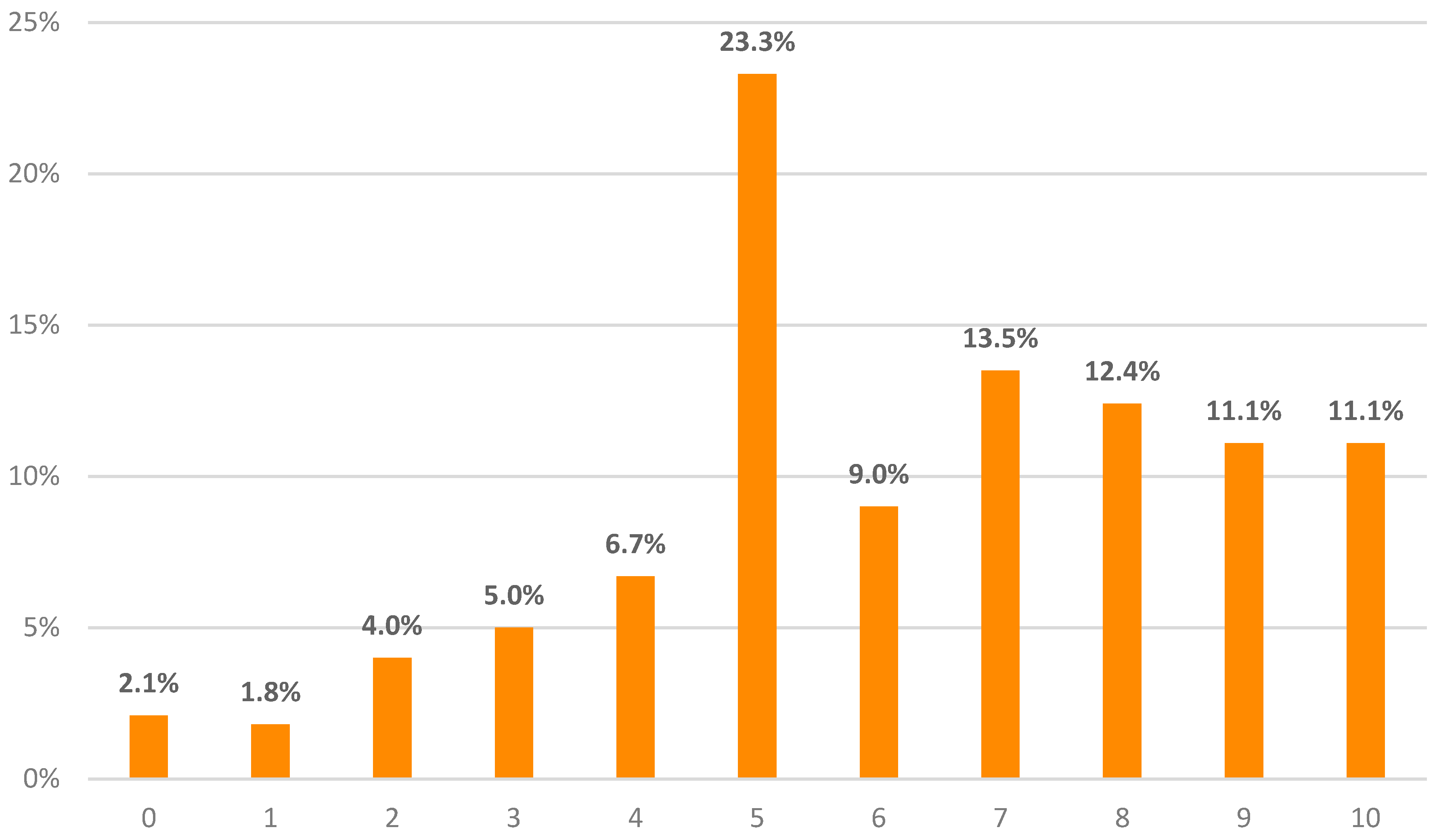
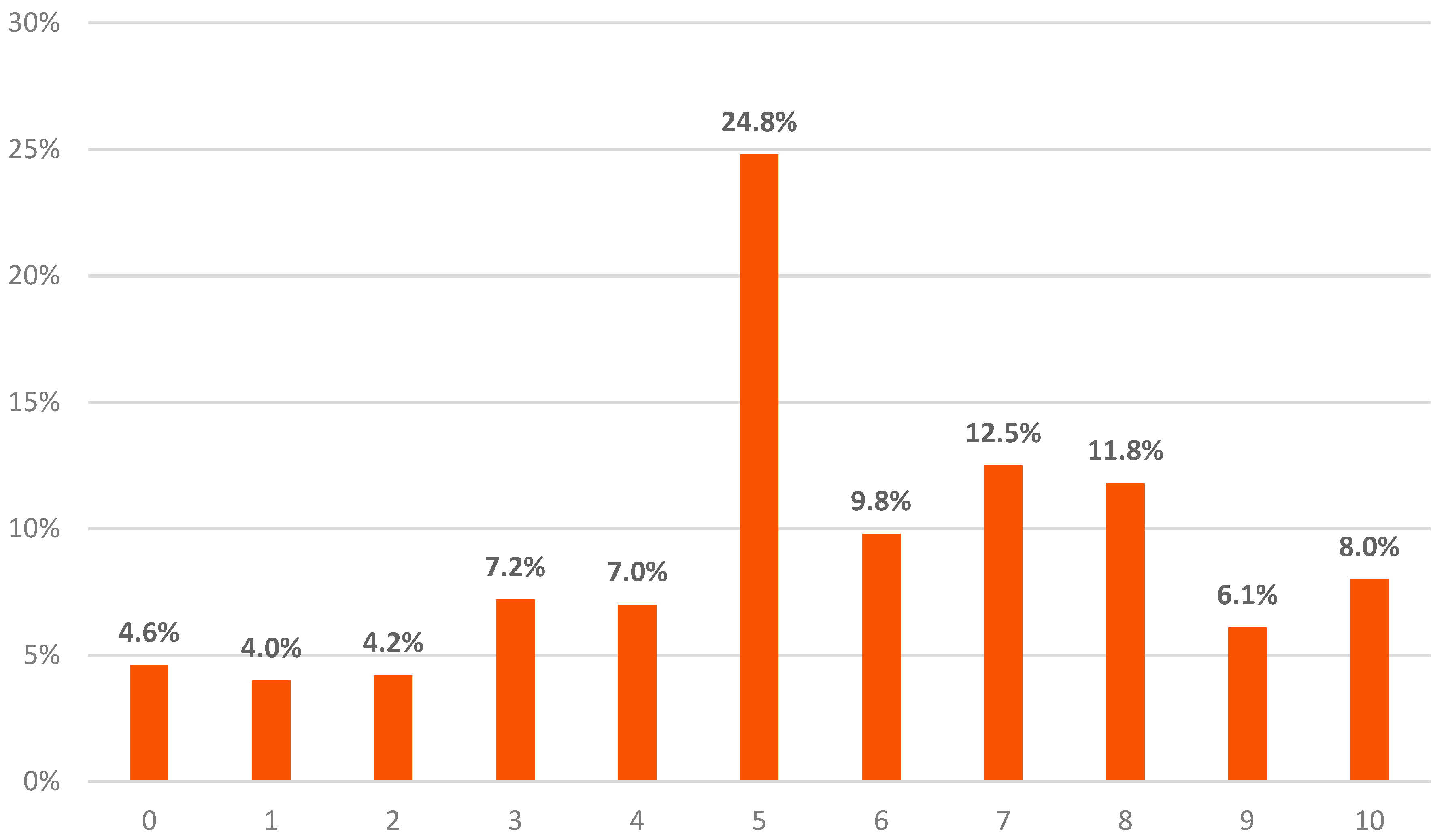
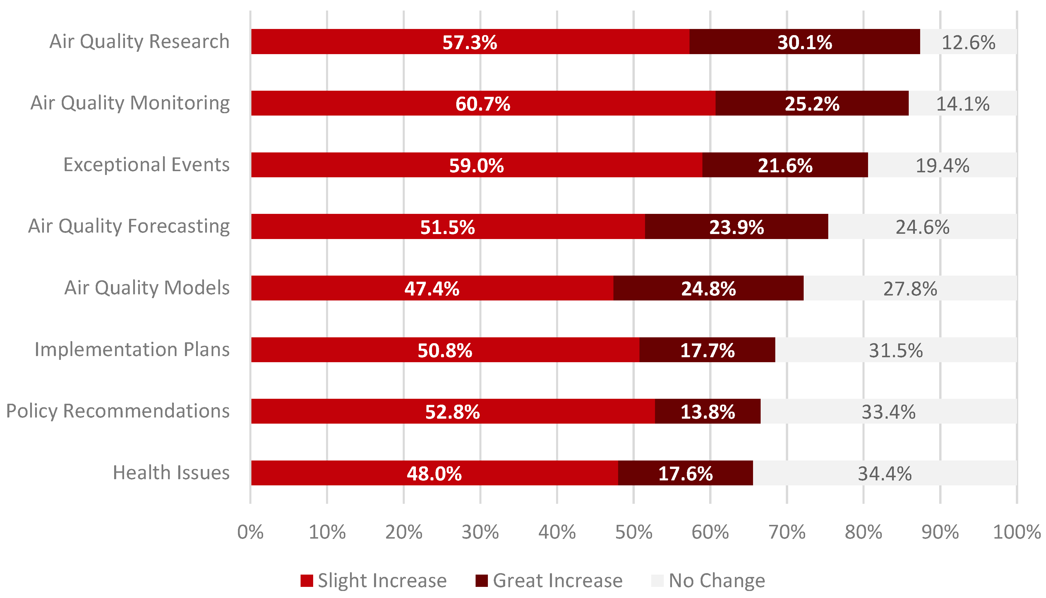
The survey was also used to understand changes in use of RSD for specific tasks. The main purpose was to gain additional insight into how participants are applying the knowledge and skills acquired through the program.
Since different areas of environmental management are associated with different types of activities, there were separate lists of tasks for each ARSET training topic. Lists of tasks span a range of activities traditionally associated with air quality, disaster, land, and water management. These include research, modeling, monitoring, and decision support activities. The goal was to design lists of activities that capture the full range of potential uses of RSD by ARSET program participants. In the survey, there were a total of 40 tasks, but respondents were directed only to the list of tasks aligned with the training they attended.
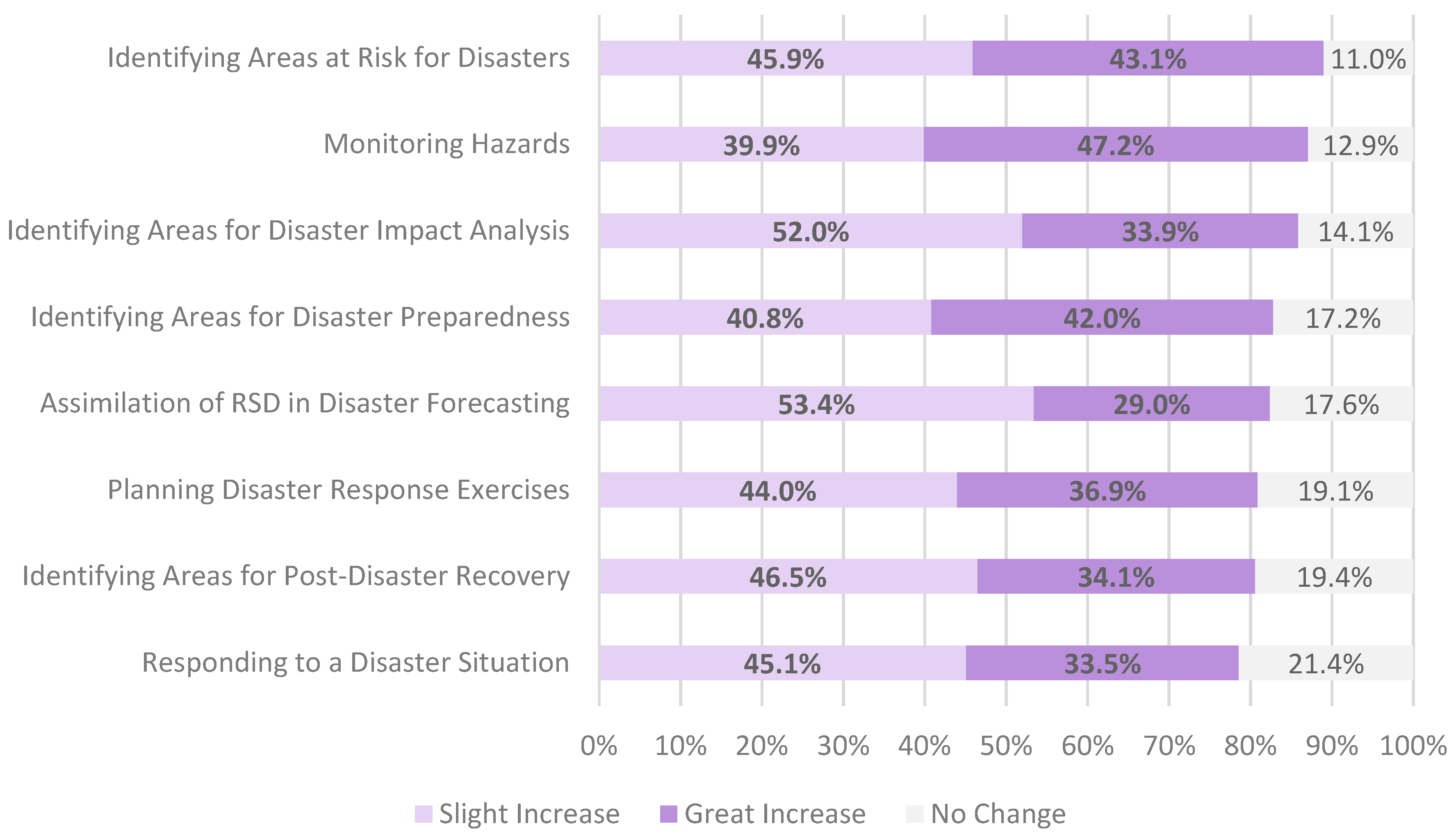
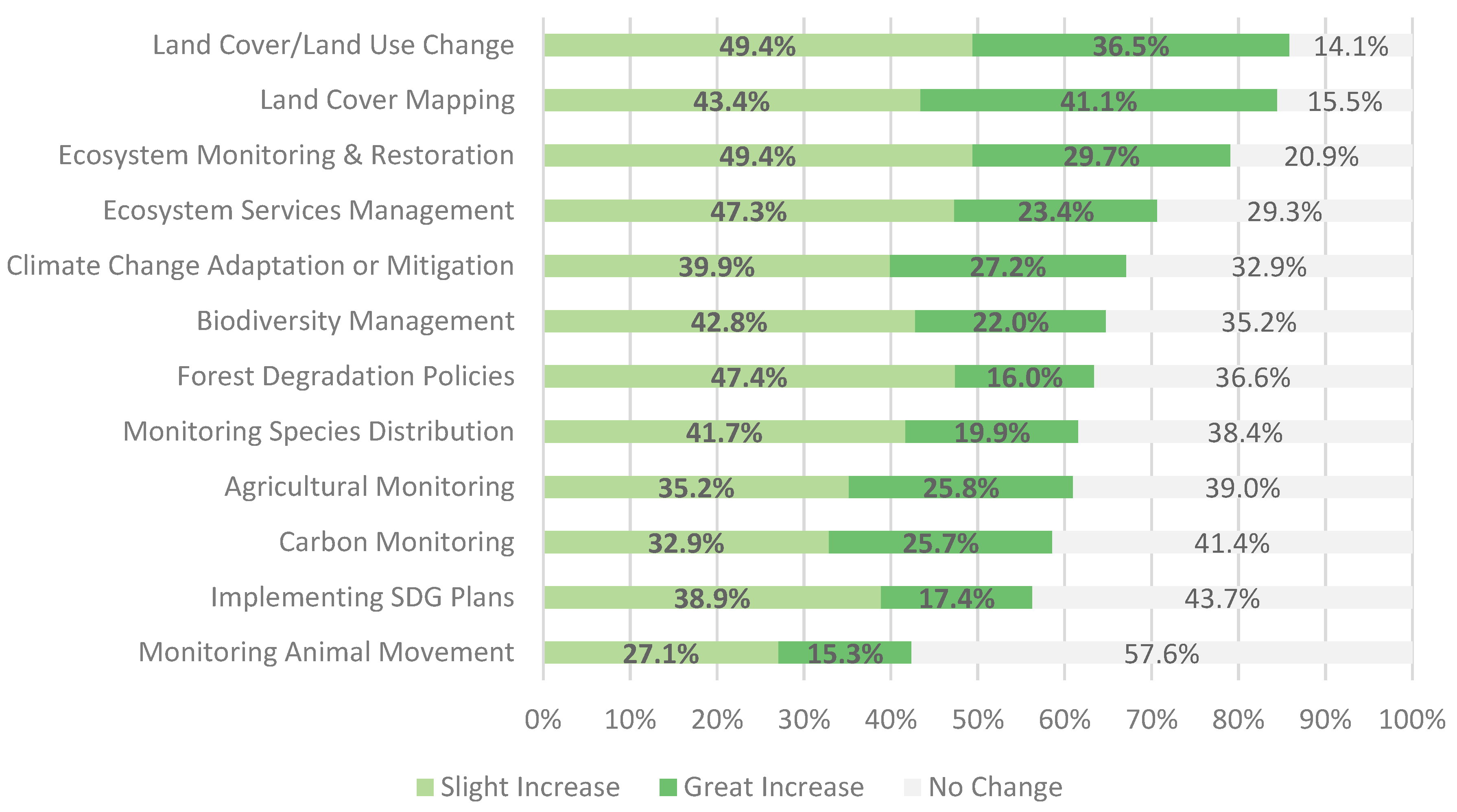
Figure 7,
Figure 8,
Figure 9 and
Figure 10 show the percentage of respondents reporting either no change, a slight increase, or a great increase in use of remote sensing for each of the 40 tasks. Respondents who indicated that a particular task was not applicable were excluded from the analysis. We show the results for air quality, disasters, land, and water applications. Health and wildfire training topics were excluded due to insufficient data.
ARSET training participants used RSD across a wide variety of tasks. More than 50% of respondents reported an increase in the use of RSD for all except two of the 40 tasks evaluated. For participants of air quality trainings, “air quality research” was the task where the largest number of respondents reported a great increase in the use of RSD (
Figure 7). Based on ARSET’s interactions with program participants, it is common for air quality professionals to be engaged in some type of research. Therefore, we expect a high fraction of attendees to improve their use of remote sensing in air quality research applications.
At least 75% of all respondents from disaster trainings reported a slight to great increase in data use for all of the disaster related tasks (
Figure 8). The results were particularly dramatic in the areas of “identifying areas at risk for disasters” (89%) and “monitoring hazards” (87%).
For land management trainings, “land-cover and land-use change (LCLUC)” and “land-cover mapping” were the tasks with the most participants reporting a great increase in use of RSD (
Figure 9). More than 78% of respondents increased their use of RSD for “LCLUC”, “land-cover mapping”, and “ecosystem monitoring and restoration”.
For water-related trainings, “monitoring water resources” was the task with the most participants reporting a great increase in the use of RSD (
Figure 10). The overall increase in data use for both “monitoring water resources” and “water resource research” was 79%.
We also expect a more positive response rate for activities where researchers and managers have a greater need for RSD. For example, based on informal communications with ARSET participants, we know that LCLUC is a high priority for a wide range of land and water resource applications; the increase in flooding events worldwide dramatically increased demand for data sources relevant to monitoring and responding to floods, and the increase in fire activity in the US increased demand for air pollution data for analyzing severe air quality events. The quantitative analyses shown here help validate and improve our current understanding of the types of environmental activities where there is greater demand for remote-sensing data, and help us plan future training activities and partnerships accordingly.
3.5. Future Training Needs
Participants provided feedback on future needs with written responses to the question “What else can NASA do to improve the usefulness of RSD for your work?” A total of 231 respondents wrote suggestions, which were coded into one of six categories. A few detailed suggestions were coded in up to three categories, resulting in a total of 302 suggestions.
The top suggestion category related to desire for more remote-sensing training, including more courses and topics (56% of respondents), followed by suggestions related to RSD needs such as user-friendly portals, open-source software, and long-term availability of satellite data (45%). The third most common suggestion related to training content, materials, assignment, organization, pacing, and presentations (20%). The three remaining categories related to training access and relevance for non-US participants (6%), as well as logistical and technical suggestions (3%), and one request related to participant interaction and networking. It is noteworthy that a very high prevalence of comments related to specific activities that NASA could undertake related to training. This indicates that there is a very high demand for remote-sensing training, and that it is viewed by participants as a key component to enabling the use of remote-sensing data.
Respondents also selected their top two preferences among a list of training sub-topics.
Table 1 shows the two most frequent choices within five topical areas. Air quality and land list selections were only offered to participants in those topical areas. Water resource training participants were also offered the disasters list, since most ARSET disaster trainings focus on flood applications. Both water and land training attendees were provided with a list of coastal and open oceans sub-topics.
ARSET regularly uses these data, together with a similar question in the exit survey, for short- and long-term planning. For example, the topics of synthetic aperture radar (SAR) and water budget estimation over watersheds were added to the training portfolio in 2017, and then developed into more advanced training in 2018. Water quality trainings were reintroduced in 2018. Additionally, as a result of participant interest, ARSET is considering adding agricultural application topics in the near future.
4. Conclusions
Remote-sensing training is an important component of overcoming barriers in the use of satellite data. Lack of access to training tailored to professionals and decision-makers has made it particularly challenging for this community to adopt remote sensing in the workplace. NASA’s ARSET program was specifically designed to address the training needs of this community. In this paper, we demonstrated the success of ARSET in increasing the use remote sensing to support a broad range of activities, including decision-making.
Our analysis of survey responses from program participants residing in 117 countries shows an increase in use of remote-sensing data across all demographic sectors, including organizations engaged in environmental policy, regulation, and management. In total, 73% of respondents reported at least a moderate improvement in decision-making as a result of their participation in the ARSET program. In addition, 83% reported at least moderate improvement in knowledge of remote sensing, and 79% improved their ability to access NASA data. For all three metrics, there were no statistically significant differences when comparing survey responses among the six ARSET training topics, or according to prior knowledge of remote sensing by survey participants.
Our findings demonstrate that online and in-person training are effective tools for building the skills to incorporate remote sensing into the workplace. Knowledge and skills gained through the ARSET program are routinely applied to air quality, disasters, land, and water resource management. Upon further analysis, we identified an increase in use of remote-sensing data across 40 specific tasks, ranging from research applications to a number of decision-making activities. More than half of the respondents reported an increase in the use of remote-sensing data for all but two of the tasks.
Evaluation is an integral aspect of the ARSET program. It is used not only to assess the impact of the program, as shown in this paper, but also for programmatic decisions. ARSET uses evaluation data to identify gaps, key environmental management challenges facing working professionals, and future training interests. This enables the program to set priorities and design training opportunities tailored to meet the needs of current and prospective participants, and to maximize the societal benefits of remote-sensing data.
Quantitative data collected through anonymous surveys cannot capture the entirety of the benefits realized by ARSET program participants and by organizations not directly involved with the program. ARSET collects additional data through interviews and other end-user feedback mechanisms that are better suited for evaluating other enabling factors. This will be the topic of a future paper.

 ,
, 


