Geographic Information Metadata—An Outlook from the International Standardization Perspective


Abstract
:1. Introduction
2. Background and Overview
2.1. Geographic Information Metadata
2.2. International Metadata Standardization Activities—A Review
- ISO 15836-1 Information and documentation—The Dublin Core metadata element set—Part 1: Core elements
- ISO/DIS 15836-2 Information and documentation—The Dublin Core metadata element set—Part 2: DCMI Properties and classes
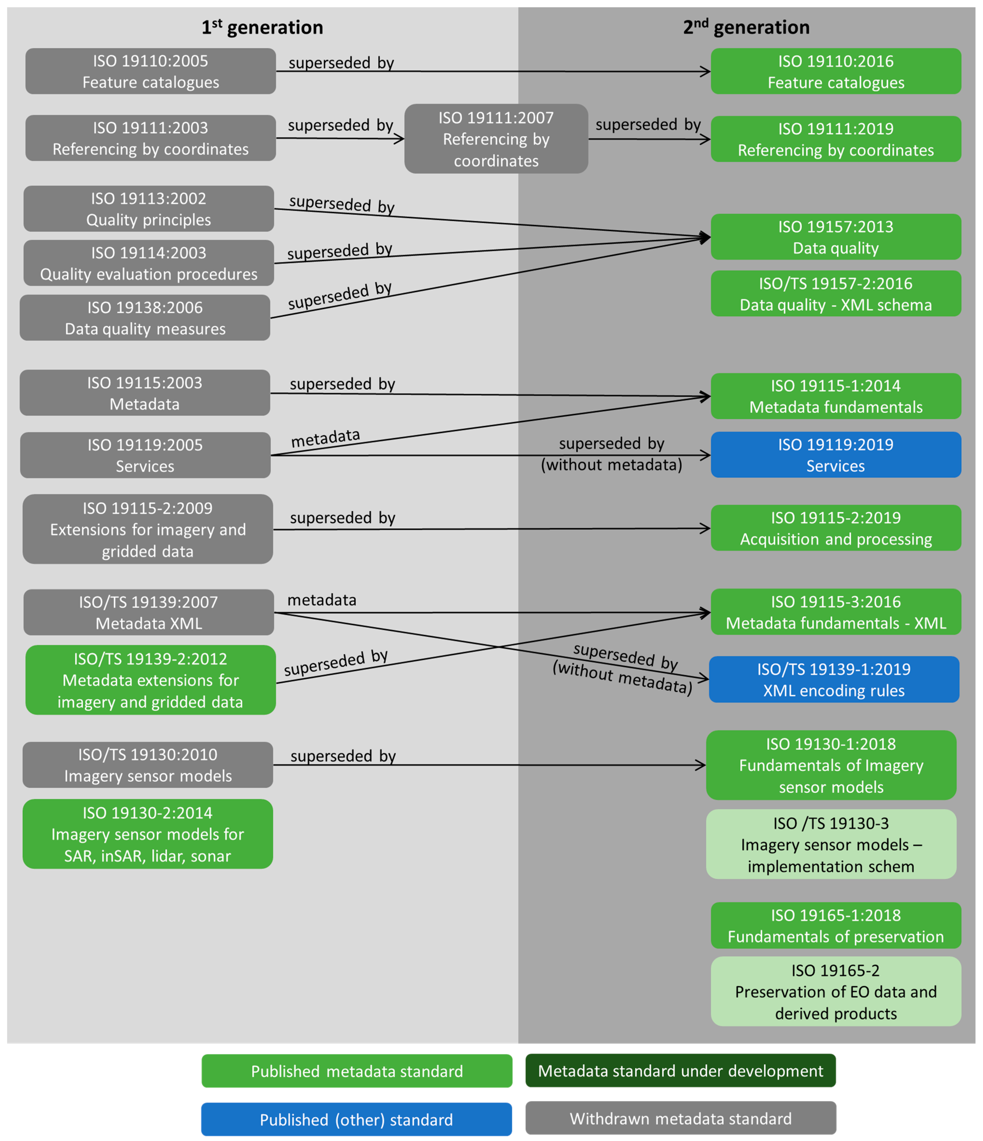
3. ISO Geographic Information Metadata Standards
3.1. Description of International Geographic Information Metadata Standards
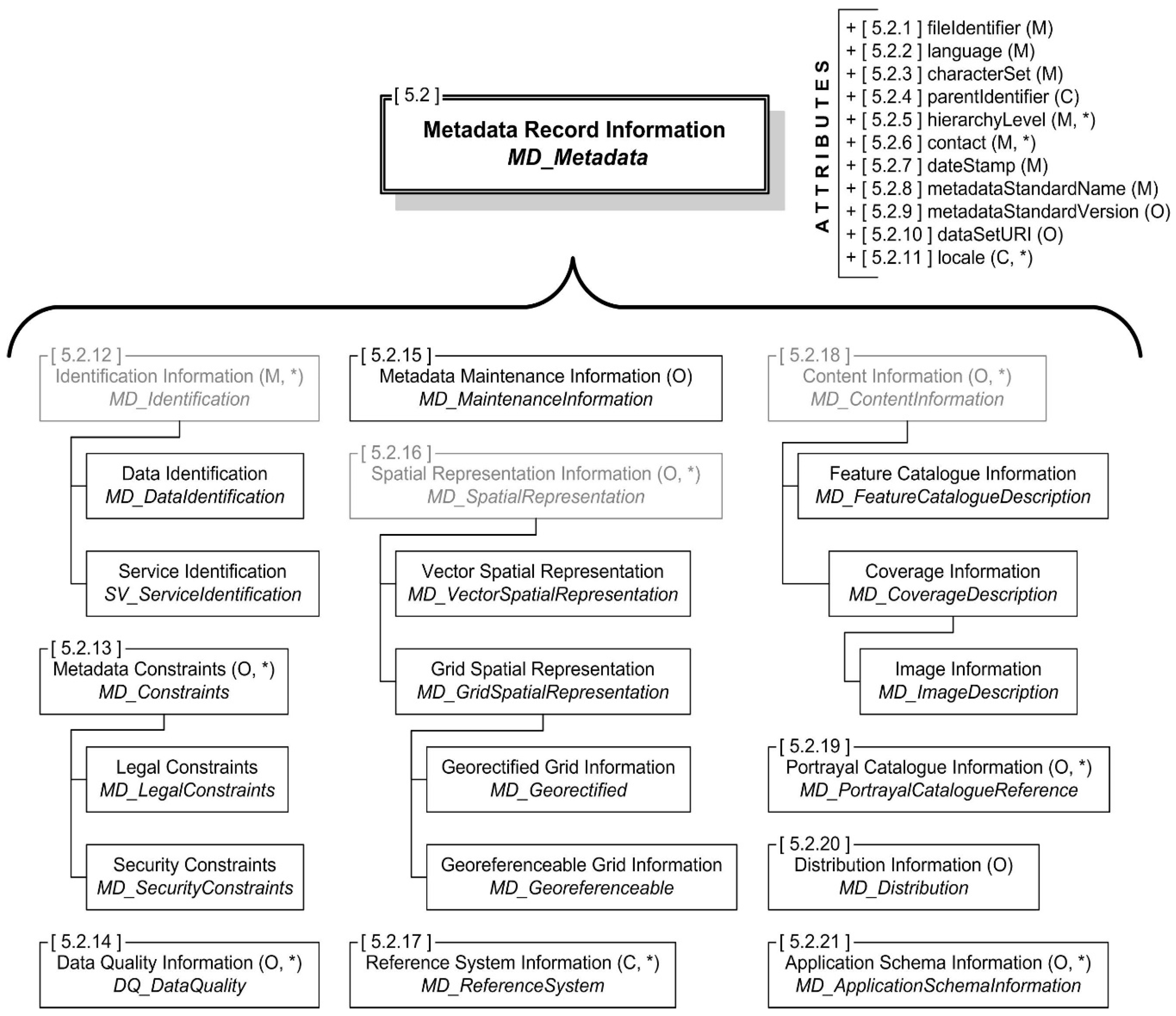
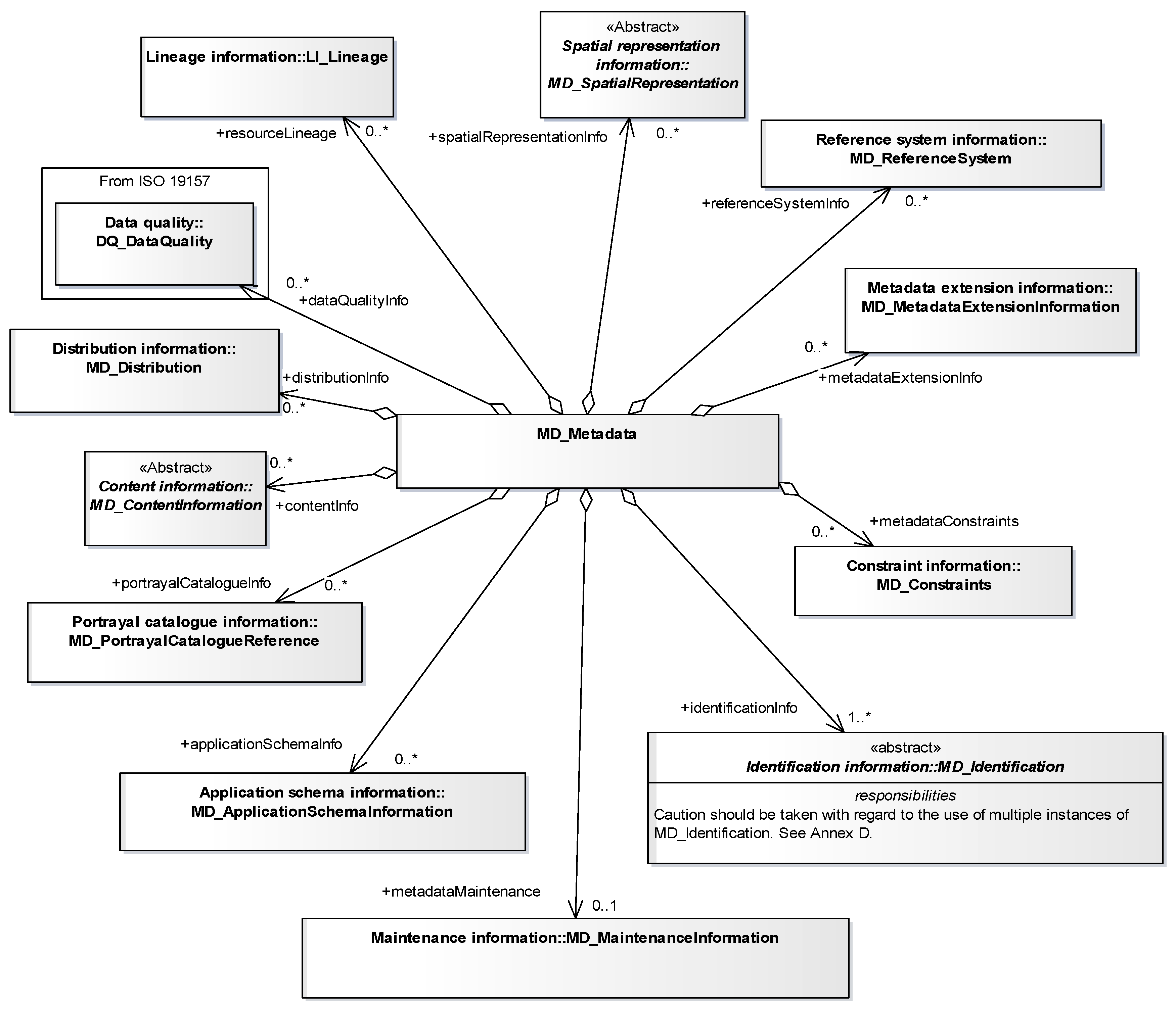
3.1.1. ISO 19115:2003, Geographic Information—Metadata
3.1.2. ISO 19115-1:2014, Geographic Information—Metadata—Part 1: Fundamentals
3.1.3. ISO 19115-2:2019, Geographic Information-Metadata-Part 2: Extensions for Acquisition and Processing
3.1.4. ISO 19115-3:2016, Geographic Information—Metadata—Part 3: XML Schema Implementation for Fundamental Concepts
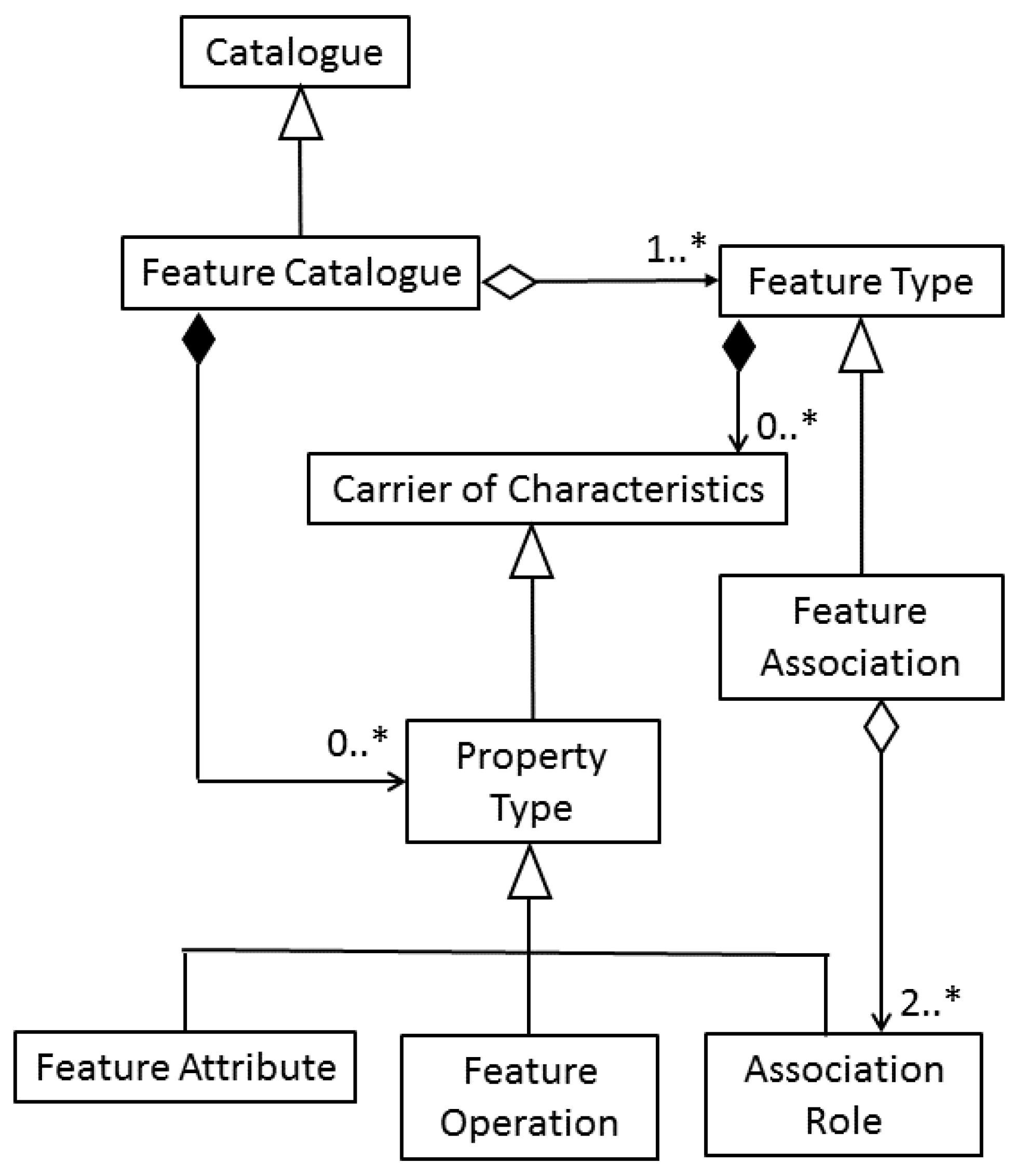
3.1.5. ISO 19110:2016, Geographic Information-Methodology for Feature Cataloguing
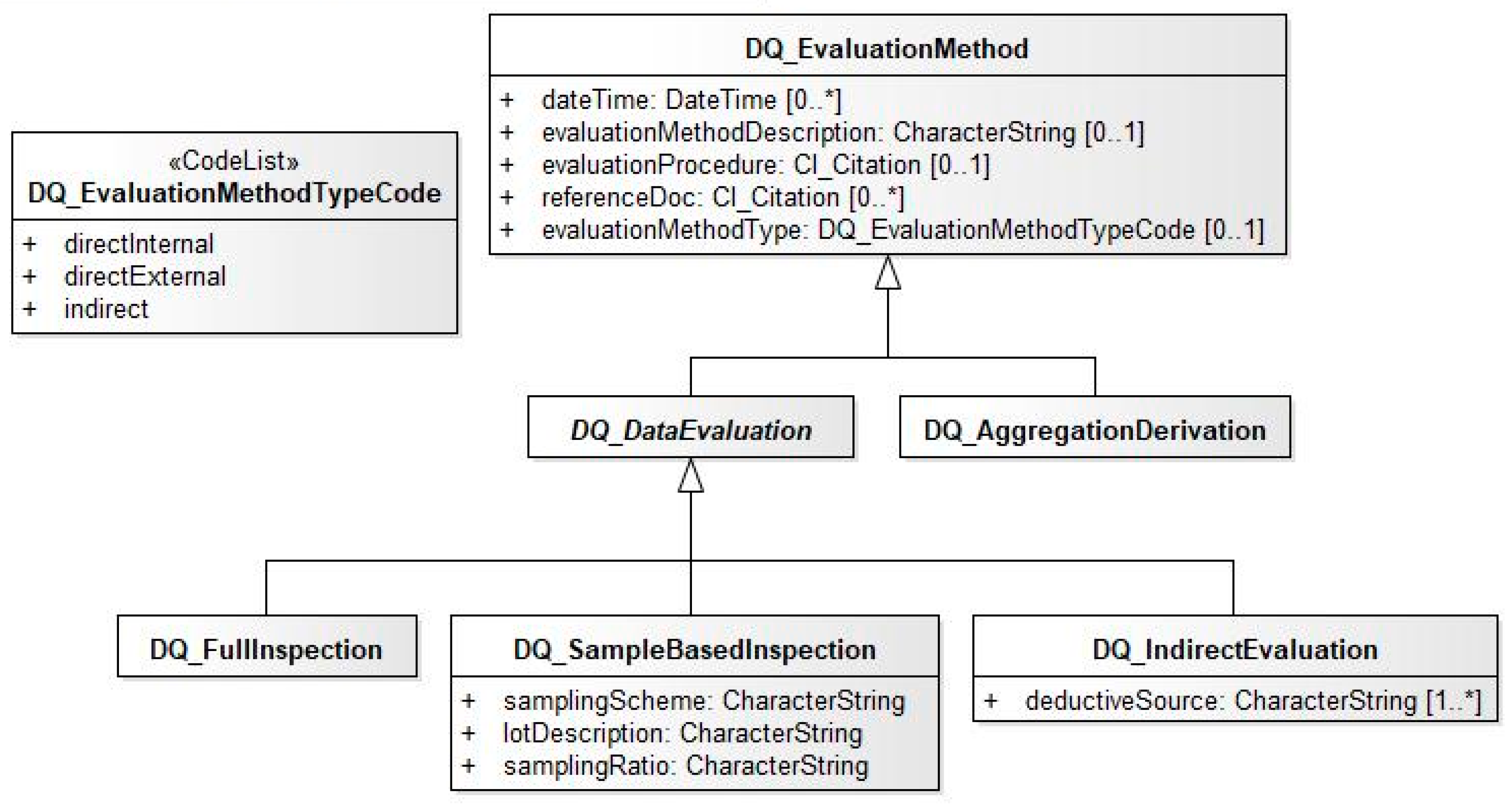
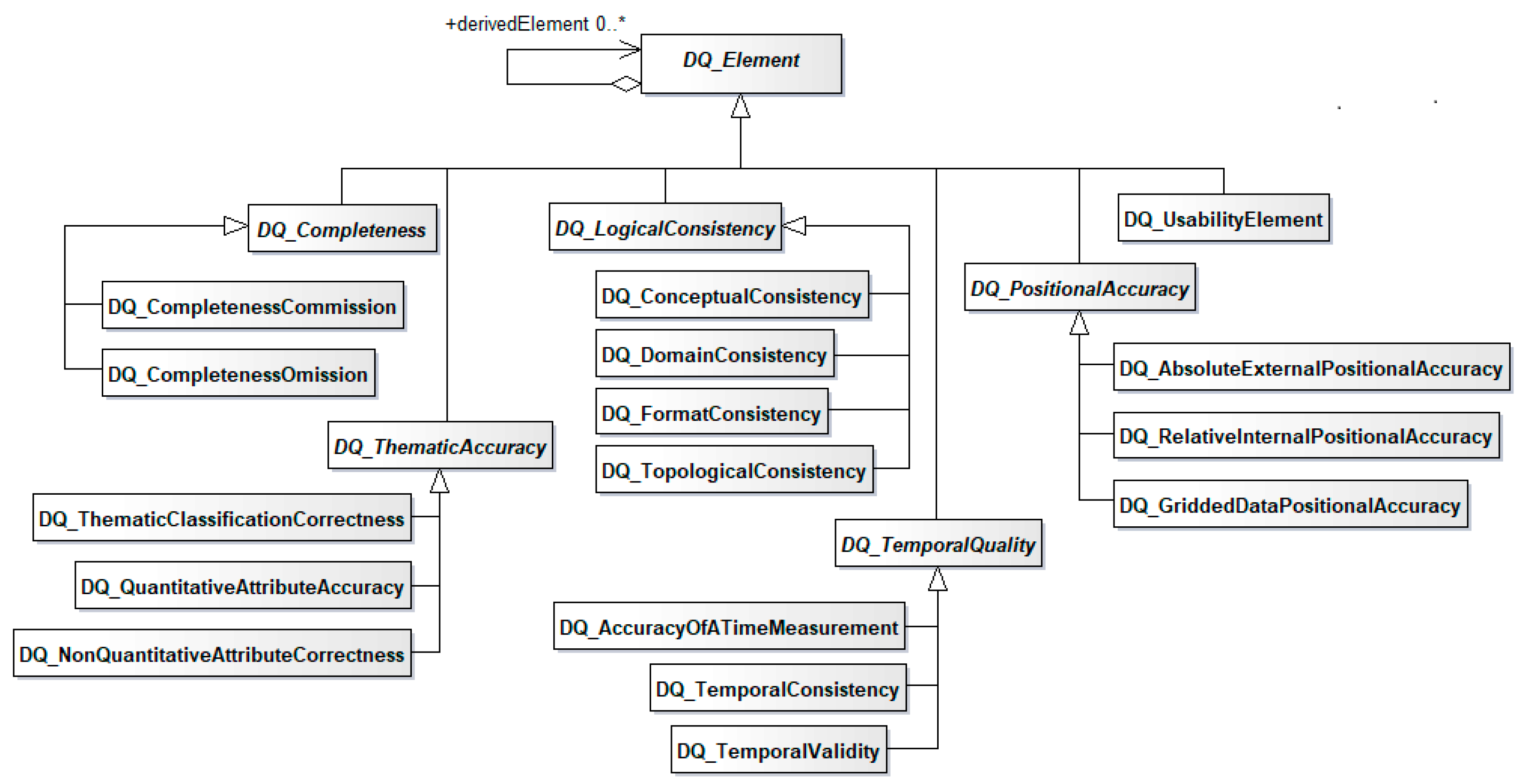
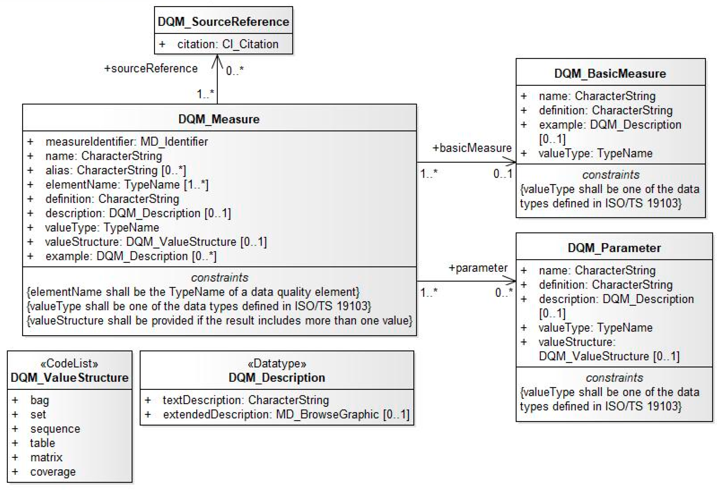
3.1.6. ISO 19157:2013, Geographic Information-Data Quality
- defining components for describing data quality;
- specifying the components and content structure of a register for data quality measures;
- describing procedures for evaluating the quality of geographic information; and,
- establishing principles for reporting data quality.
3.1.7. ISO 19157-2:2016, Geographic Information—Data Quality—Part 2: XML Schema Implementation
3.1.8. ISO 19165-1:2018, Geographic Information—Preservation of Digital Data and Metadata—Part 1: Fundamentals
3.1.9. ISO 19165-2, Geographic Information—Preservation of Digital Data and Metadata—Part 2: Content Specifications for Earth Observation Data and Derived Digital Products
3.2. Resources Supporting Implementations
- Interoperability across domains;
- Expose ISO/TC211 standards to other communities that are not aware of the spatial domain;
- Automatic machine reasoning and inference;
- From information description to knowledge description;
- Focus on online access of information and knowledge (as opposed to offline access);
- Interrelate similar/different concepts (such as different keywords for similar concepts in metadata);
- Associate (similar/different) concepts between domains.
4. Applying International Geographic Metadata Standards
4.1. Profiles
- A pure subset of ISO standards (also known as a class 1 profile);
- An extended profile where non-ISO standard are added (also known as a class 2 profile).
4.1.1. The North American Profile
4.1.2. The DGIWG Profile
- Core: Minimum set of metadata elements to be implemented by any metadata catalogue
- Common: Additional set of metadata elements for a more complete description of any type of resource supported by DMF. It extends DMF/Core.
- Services: Extension of DMF/Core for service metadata that can be used together with DMF/Common (i.e., it is possible to use DMF/Services on top of DMF/Core if DMF/Common elements are not needed or on top of DMF/Common for an extensive profile).
- Data: extension of DMF/Common for data related resources (i.e., dataset, series, and tile).
- Data+: Extension of DMF/Data for the implementation of coverage quality results and other metadata elements introduced in ISO 19115-2 but with some applications for any geospatial products.
- Sensor: Extension of DMF/Data for sensors.
- Defence: Extension of DMF/Common for NATO and more generally military oriented needs (particularly for security). It is needed to handle metadata to be exchanged with NATO in conformance with a NATO specific metadata profile of DGIWG 2014.
- Specific: Extension of the ISO metadata standards for high level military implementation of the DMF metadata elements.
- Discovery (D): The most important metadata elements, i.e., the metadata elements involved when a user needs to discover existing resources;
- Evaluation (E): The metadata elements needed to understand whether the discovered resources meet the user requirements;
- Use (U): The metadata elements needed to access and use the resource;
- Management (M): The metadata elements needed to manage the existing resources.
- Metadata Releasability Addressee
- Resource Releasability
- Resource Data Level
4.1.3. The INSPIRE Profile
4.2. Use Cases of Geographic Information Metadata Implementation
4.3. Software or Applications
4.3.1. Esri
- -
- FGDC,
- -
- ISO 19115 + 19139,
- -
- ISO 19115 + 19139 + GML3.2,
- -
- North American Profile of 19115/19119 + 19139,
- -
- INSPIRE Metadata Profile,
- -
- Esri Item Description, and
- -
- Profiles, such as the SDSFIE-M using the metadata toolkit.
- Improve the efficiency and effectiveness of geospatial activities within the enterprise and across organizations,
- Support collaboration and cooperation among departments and organizations by facilitating the sharing of geospatial resources regardless of the GIS platform,
- Gain an enterprise-level awareness of disparate geospatial data, Web services, and activities,
- Leverage existing geospatial resources so the organization does not duplicate those resources or the effort to create them,
- Ensure the use of approved, high-quality datasets, and
- Reduce the time users spend trying to find relevant, usable geospatial resources.
- -
- Dublin Core (http://dublincore.org/documents/dces/), which corresponds to ISO 15836:2009,
- -
- FGDC (with profiles such as the BLM Profile),
- -
- ISO 19115/19115-2/19119/19157 + 19139,
- -
- INSPIRE Metadata Profile,
- -
- UK Gemini Profile R1r2 and R2r2 of INSPIRE Profile of ISO (…),
- -
- North American Profile of ISO 19115/19119+10139,
- -
- SDSFIE-M profile of 19115/19119 + 19139,
- -
- -
- NATO Geospatial Metadata Profile NGMP (https://github.com/Esri/geoportal-server/tree/master/geoportal/profiles/metadata/iso/ngmp),
- -
- W3C DCAT,
- -
- OGC CSW Service metadata, and
- -
- ArcGIS Metadata (and its styles).
4.3.2. GeoNetwork
4.3.3. Catalogue Web Service
- GetCapabilities: This operation is common for all OGC webservices and allows one to get information on the CSW service (version, operations, formats, etc.).
- GetDomain: Retrieves information about the valid values of one or more named metadata properties.
- GetRecords: Retrieves metadata about several elements
- GetRecordById: Retrieves metadata about one specific element.
- Harvest: Requests the Catalogue Service to retrieve resource metadata from a specified location, often on a regular basis—this behaviour reflects a ‘pull’ style of publication.
- Transaction: performs a specified set of “insert”, “update”, and “delete” actions on metadata items stored by a Catalogue Service implementation—this enables a “push” style of publication
https://services.data.shom.fr/geonetwork/srv/eng/csw?service=CSW&request=GetRecordById&elementSetName=full&version=2.0.2&id=urn:SDN:CDI::2117147
<?xml version=“1.0” encoding=“UTF-8”?>
<csw:GetRecordByIdResponse xmlns:csw=“http://www.opengis.net/cat/csw/2.0.2”>
 <csw:Record xmlns:dc=“http://purl.org/dc/elements/1.1/” xmlns:geonet=“http://www.fao.org/geonetwork” xmlns:ows=“http://www.opengis.net/ows” xmlns:dct=“http://purl.org/dc/terms/”>
 <dc:identifier>urn:SDN:CDI::2117147</dc:identifier>
 <dc:date>2014-03-26</dc:date>
 <dc:title>S201209300-2</dc:title>
 <dc:type>dataset</dc:type>
 <dc:subject>Oceanographic geographical features</dc:subject>
 <dc:subject>Bathymetry and Elevation</dc:subject>
 <dc:subject>multi-beam echosounders</dc:subject>
 <dc:subject>research vessel</dc:subject>
 <dc:subject>oceans</dc:subject>
 <dc:format>Ocean Data View ASCII input</dc:format>
 <dct:modified>2013-02-04</dct:modified>
 <dc:creator>Shom</dc:creator>
 <dct:abstract>Suite au message de la vedette des douanes de Brest « Kermorvan » (cité en référence a) et figurant en annexe V du RAP2012-121), un levé bathymétrique a été réalisé dans l’objectif de statuer sur les anomalies constatées sur la valeur de deux sondes de la CM7095. - levé bathymétrique 1b - 171 sondes/soundings</dct:abstract>
 <dc:description>Suite au message de la vedette des douanes de Brest « Kermorvan » (cité en référence a) et figurant en annexe V du RAP2012-121), un levé bathymétrique a été réalisé dans l’objectif de statuer sur les anomalies constatées sur la valeur de deux sondes de la CM7095. - levé bathymétrique 1b - 171 sondes/soundings</dc:description>
 <dc:rights>otherRestrictions</dc:rights>
 <dc:language>eng</dc:language>
 <dc:source>The data centres apply standard data quality control procedures on all data that the centres manage. Ask the data centre for details.</dc:source>
 <dc:format>Ocean Data View ASCII input</dc:format>
 <ows:BoundingBox crs=“urn:ogc:def:crs:EPSG:6.6:4326”>
 <ows:LowerCorner>-3.88585 48.6959</ows:LowerCorner>
 <ows:UpperCorner>-3.89569 48.70609</ows:UpperCorner>
 </ows:BoundingBox>
 <dc:URI protocol=“HTTP-DOWNLOAD”>http://www.sdn-taskmanager.org/</dc:URI>
 </csw:Record>
</csw:GetRecordByIdResponse>
4.3.4. Data Catalog Vocabulary
4.3.5. GeoNode
4.3.6. French INSPIRE SDI
5. Discussion
6. Concluding Remarks
Author Contributions
Funding
Acknowledgments
Conflicts of Interest
References
- ISO/TC 211. ISO19115-1:2014 Geographic Information—Metadata—Part 1: Fundamentals; International Organization for Standardization: Geneva, Switzerland, 2014; p. 167. [Google Scholar]
- Brodeur, J. ISO 19115 + other GIS: Geographic Information—Metadata. In Proceedings of the 10th Annual Open Forum for Metadata Registries, New York, NY, USA, 9–11 July 2007. [Google Scholar]
- Moellering, H.; Aalders, H.; Crane, A. (Eds.) World Spatial Metadata Standards; Elsevier Ltd.: London, UK, 2005; p. 689. [Google Scholar]
- ISO/TC 211. Geographic Information/Geomatics. Available online: https://committee.iso.org/home/tc211 (accessed on 1 June 2006).
- ISO/TC 211. ISO19113:2002 Geographic Information—Quality Principles; International Organization for Standardization: Geneva, Switzerland, 2002; p. 29. [Google Scholar]
- ISO/TC 211. ISO19115:2003 Geographic Information—Metadata; International Organization for Standardization: Geneva, Switzerland, 2003; p. 140. [Google Scholar]
- ISO/TC 211. ISO19114:2003 Geographic Information—Quality Evaluation Procedure; International Organization for Standardization: Geneva, Switzerland, 2003; p. 63. [Google Scholar]
- ISO/TC 211. ISO19119:2005 Geographic Information—Services; International Organization for Standardization: Geneva, Switzerland, 2005; p. 74. [Google Scholar]
- ISO/TC 211. ISO/TS19138:2006 Geographic Information—Data Quality Measures; International Organization for Standardization: Geneva, Switzerland, 2006. [Google Scholar]
- ISO/TC 211. ISO/TS19139:2007 Geographic Information—Metadata—XML Schema Implementation; International Organization for Standardization: Geneva, Switzerland, 2007; p. 111. [Google Scholar]
- ISO/TC 211. ISO19115-2:2009 Geographic Information—Metadata—Part 2: Extensions for Imagery and Gridded Data; International Organization for Standardization: Geneva, Switzerland, 2009.
- Danko, D.M. Geospatial Metadata. In Springer Handbook of Geographic Information, 1st ed.; Kresse, W., Danko, D.M., Eds.; Springer: Berlin/Heidelberg, Germany, 2012; pp. 359–391. [Google Scholar]
- FGDC. FGDC-STD-001-1998—Content Standard for Digital Geographic Metadata; Federal Geographic Data Committee: Washington, DC, USA, 1998; p. 78.
- Federal Register. Coordinating Geographic Data Acquisition and Access: The National Spatial Data Infrastructure; Executive Order 12906 of April 11, 1994; Presidential Documents, Wednesday, 13 April 1994; Office of the Federal Register: Washington, DC, USA, 1994; Volume 59. [Google Scholar]
- Aalders, H.J.; Salgé, F.; Martynenko, A.I. European Efforts in the Field of Geographic Metadata and Related SDI Activities. In World Spatial Metadata Standards; Moellering, H., Aalders, H.J., Crane, A., Eds.; Elsevier: Amsterdam, The Netherlands, 2005; pp. 31–62. [Google Scholar]
- CEN. prENV 12657:1998, Geographic Information—Data Description—Metadata; European Committee for Standardization: Brussels, Belgium, 1998. [Google Scholar]
- ANZLIC. ANZLIC Working Group on Metadata: Core Metadata Elements; Australia and New Zealand Land Information Council: Sydney, Australia, 1995.
- CGSB. CAN/CGSB-171.2-94 Geomatic Data Sets Cataloguing Rules; Canadian General Standards Board: Ottawa, ON, Canada, 1994.
- CGSB. CAN/CGSB-171.3-95 Directory Information Describing Digital Geo-Referenced Data Sets; Canadian General Standards Board: Ottawa, ON, Canada, 1995.
- Open Geospatial Consortium Inc. Topic 11: Metadata (OGC 11-111r1). In The OpenGIS Abstract Specification, version 4; Open GIS Consortium Inc.: Wayland, MA, USA, 2016. [Google Scholar]
- STAC. SpatioTemporal Asset Catalogs. Available online: https://stacspec.org/ (accessed on 17 May 2019).
- ISO/IEC. ISO/IEC 11179-1:2004, Information Technology—Metadata Registries (MDR)—Part 1: Framework; International Organization for Standardization: Geneva, Switzerland, 2004. [Google Scholar]
- Kresse, W.; Fadaie, K. ISO Standards for Geographic Information; Springer: Berlin/Heidelberg, Germany, 2004; p. 323. [Google Scholar]
- ISO/TC 211. ISO/TC 211 Geographic Information/Geomatics—Organization. Available online: https://committee.iso.org/sites/tc211/home/about/organisation.html (accessed on 30 April 2019).
- ISO/TC 211. ISO/TC 211 Geographic Information/Geomatics—Resolutions. Available online: https://committee.iso.org/sites/tc211/home/resolutions.html (accessed on 30 April 2019).
- Brodeur, J. Geosemantic interoperability and the Geospatial Semantic Web. In Springer Handbook of Geographic Information; Kresse, W., Danko, D., Eds.; Springer: Berlin/Heidelberg, Germany, 2012; pp. 589–611. [Google Scholar]
- ISO/TC 211. Geographic Technology Standard Models & Schemas. Available online: https://www.isotc211.org/ (accessed on 30 April 2019).
- ISO/TC 211. ISO19106:2004 Geographic Information—Profiles; International Organization for Standardization: Geneva, Switzerland, 2004; p. 32. [Google Scholar]
- ISO/TC 211. Geographic Information—Web Map Server Interface; International Organization for Standardization: Geneva, Switzerland, 2005; p. 103. [Google Scholar]
- Open Geospatial Consortium Inc. OpenGIS Web Map Service (WMS) Implementation Specification—1.3.0. In OpenGIS Implementation Specification; OpenGIS Consortium Inc.: Wayland, MA, USA, 2006; p. 85. [Google Scholar]
- Open Geospatial Consortium Inc. OGC® Web Feature Service 2.0 Interface Standard—With Corrigendum—2.0.2. In OpenGIS Implementation Specification; OpenGIS Consortium Inc.: Wayland, MA, USA, 2014; p. 254. [Google Scholar]
- Open Geospatial Consortium Inc. OGC Catalogue Services 3.0—General Model; Open Geospatial Consortium Inc.: Wayland, MA, USA, 2016. [Google Scholar]
- ISO/TC 211. ISO19119:2016 Geographic Information—Services; International Organization for Standardization: Geneva, Switzerland, 2016; p. 103. [Google Scholar]
- Brodeur, J.; Danko, D. NAP—Metadata: Content, Structure, and Register. In Proceedings of the IPY GeoNorth 2007: First International Circumpolar Conference on Geospatial Sciences and Applications, Yellowknife, NT, Canada, 20–24 August 2007. [Google Scholar]
- DGIWG. DGIWG 114: DGIWG Metadata Foundation; DGIWG: Northwood, UK, 2014. [Google Scholar]
- European Parliament—Council of the European Union. Directive 2007/2/EC of the European Parliament and of the Council of 14 March 2007 establishing an Infrastructure for Spatial Information in the European Community (INSPIRE). Off. J. Eur. Union 2007, L108. [Google Scholar]
- European Commission. COMMISSION REGULATION (EC) No 1205/2008 of 3 December 2008 Implementing Directive 2007/2/EC of the European Parliament and of the Council as Regards Metadata; The Publications Office of the European Union: Luxembourg, 2008; Volume L 326. [Google Scholar]
- European Commission. COMMISSION REGULATION (EC) No 976/2009 of 19 October 2009 Implementing Directive 2007/2/EC of the European Parliament and of the Council as Regards the Network Services; The Publications Office of the European Union: Luxembourg, 2009; Volume L 274. [Google Scholar]
- European Commission. COMMISSION REGULATION (EU) No 1089/2010 of 23 November 2010 Implementing Directive 2007/2/EC of the European Parliament and of the Council as Regards Interoperability of Spatial Data Sets and Services; The Publications Office of the European Union: Luxembourg, 2010; Volume L 323. [Google Scholar]
- European Commission Joint Research Centre. INSPIRE Metadata Implementing Rules: Technical Guidelines Based on EN ISO 19115 and EN ISO 19119; European Commission Joint Research Centre: Ispra, Italy, 2013. [Google Scholar]
- European Commission Joint Research Centre. D2.8.I.8 Data Specification on Hydrography—Technical Guidelines; European Commission Joint Research Centre: Ispra, Italy, 2014. [Google Scholar]
- EIONET. GEMET—INSPIRE Spatial Data Themes. Available online: https://www.eionet.europa.eu/gemet/en/inspire-themes/ (accessed on Day 30 April 2019).
- Esri. Esri’s Open Vision—Open Standards. Available online: https://www.esri.com/en-us/arcgis/open-vision/standards/open-standards (accessed on 30 April 2019).
- GeoNetwork. GeoNetwork User Manual, Release 2.10.4-0; GeoNetwork: Saint-Pierre-de-Genebroz, France, 2019. [Google Scholar]
- Open Source Geospatial Foundation. GeoNetwork oppensource. Available online: https://geonetwork-opensource.org/ (accessed on 30 April 2019).
- GeoNode. GeoNode’s Documentation. Available online: http://docs.geonode.org/en/master/# (accessed on 18 May 2019).
- IGN. Géoportail. Available online: https://www.geoportail.gouv.fr/ (accessed on 30 April 2019).
- BRGM. Géocatalogue. Available online: http://www.geocatalogue.fr/ (accessed on 30 April 2019).
- Vilmus, T.; Taffoureau, E.; Cailleau, C. Géocatalogue et GéoSource Rapport d’activités 2016; BRGM: Orleans, France, 2016; p. 59.
- Kalantari, M.; Rajabifard, A.; Olfat, H.; Williamson, I. Geospatial Metadata 2.0—An approach for Volunteered Geographic Information. Comput. Environ. Urban Syst. 2014, 48, 35–48. [Google Scholar] [CrossRef]
- Giuliani, G.; Guigoz, Y.; Lacroix, P.; Ray, N.; Lehmann, A. Facilitating the production of ISO-compliant metadata of geospatial datasets. Int. J. Appl. Earth Obs. Geoinf. 2016, 44, 239–243. [Google Scholar] [CrossRef]
- Ennis, A.; Nugent, C.; Morrow, P.; Chen, L.; Ioannidis, G.; Stan, A.; Rachev, P. A Geospatial Semantic Enrichment and Query Service for Geotagged Photographs. Sensors 2015, 15, 17470–17482. [Google Scholar] [CrossRef] [PubMed]
- Renteria-Agualimpia, W.J.; López-Pellicer, F.; Lacasta, J.; Zarazaga-Soria, F.J.; Muro-Medrano, P.R. Identifying Hidden Geospatial Resources in Catalogues. In Proceedings of the WIMS ‘13: Proceedings of the 3rd International Conference on Web Intelligence, Mining and Semantics, Madrid, Spain, 12–14 June 2013. [Google Scholar]
- Aissi, S.; Sboui, T. Towards Evaluating Geospatial Metadata Quality in the Context of VGI. Procedia Comput. Sci. 2017, 109C, 686–691. [Google Scholar] [CrossRef]
- Hou, D.; Chen, J.; Wu, H. Discovering Land Cover Web Map Services from the Deep Web with JavaScript Invocation Rules. ISPRS Int. J. Geo-Inf. 2016, 5, 105. [Google Scholar] [CrossRef]
- Huang, C.; Chang, H. GeoWeb Crawler: An Extensible and Scalable Web Crawling Framework for Discovering Geospatial Web Resources. ISPRS Int. J. Geo-Inf. 2016, 5, 136. [Google Scholar] [CrossRef]
- Ivánová, I.; Morales, J.; de By, R.A.; Beshe, T.S.; Gebresilassie, M.A. Searching for spatial data resources by fitness for use. J. Spat. Sci. 2013, 58, 15–28. [Google Scholar] [CrossRef]
- Katumba, S.; Coetzee, S. Employing search engine optimization (SEO) techniques for improving the discovery of geospatial resources on the Web. ISPRS Int. J. Geo-Inf. 2017, 6, 284. [Google Scholar] [CrossRef]
- Zhang, J.; Dimitroff, A. Internet search engines’ response to metadata Dublin Core implementation. J. Inf. Sci. 2004, 30, 310–320. [Google Scholar] [CrossRef]
- Fugazza, C.; Pepe, M.; Oggioni, A.; Tagliolato, P.; Carrara, P. Raising Semantics-Awareness in Geospatial Metadata Management. ISPRS Int. J. Geo-Inf. 2018, 7, 370. [Google Scholar] [CrossRef]
- Nogueras-Iso, J.; Zarazaga-Soria, F.J.; Lacasta, J.; Bejar, R.B.; Muro-Medrano, P.R. Metadata standard interoperability: Application in the geographic information domain. Comput. Environ. Urban Syst. 2004, 28, 611–634. [Google Scholar] [CrossRef]


| Standard Name | Description | Year of Publication | Generation | Status |
|---|---|---|---|---|
| ISO 19110, Geographic information—Methodology for feature cataloguing | Defines a methodology for developing a catalogue defining feature and properties for a domain of interest and/or a dataset. | 2005 | 1st | Withdrawn, superseded by ISO 19110:2016 |
| 2016 | 2nd | Published | ||
| ISO 19111, Geographic information—Referencing by coordinates | The model allows coordinate reference system metadata to be provided. | 2003 | 1st | Withdrawn, superseded by ISO 19111:2007 |
| 2007 | 1st+ | Withdrawn, superseded by ISO 19111:2019 | ||
| 2019 | 2nd | Published | ||
| ISO 19113, Geographic information—Quality principles | Defines the principles, the elements/sub-elements of data quality. | 2002 | 1st | Withdrawn, superseded by ISO 19157 |
| ISO 19114, Geographic information—Quality evaluation procedures | Defines procedures for determining data quality. | 2003 | 1st | Withdrawn, superseded by ISO 19157 |
| ISO 19115, Geographic information—Metadata | Defines metadata elements and schema describing geospatial datasets. | 2003 | 1st | Withdrawn, superseded by ISO 19115-1:2014 |
| ISO 19115-1, Geographic information-Metadata—Part 1: Fundamentals | Defines metadata elements and schema describing geospatial datasets. | 2014 | 2nd | Published |
| ISO 19115-2, Geographic information—Metadata—Part 2: Extensions for imagery and gridded data | Extends ISO 19115 (original metadata standard) by defining additional metadata elements and schema describing imagery and gridded geospatial datasets. | 2009 | 1st | Withdrawn, superseded by ISO 19115-2:2019 |
| ISO 19115-2, Geographic information—Metadata—Part 2: Extensions for acquisition and processing | Extends ISO 19115-1 (revised metadata standard) by defining the schema required for an enhanced description of the acquisition and processing of geographic information, including imagery. Also provides the XML encoding for acquisition and processing metadata thereby extending the XML schemas defined in ISO/TS 19115-3. | 2019 | 2nd | Published |
| ISO/TS 19115-3, Geographic information—Metadata—Part 3: XML schema implementation for fundamental concepts | Defines an integrated XML implementation of ISO 19115-1, ISO 19115-2, and concepts from ISO/TS 19139, and describes the procedure for generating XML schema from ISO geographic information conceptual models related to metadata. | 2016 | 2nd | Published |
| ISO 19119, Geographic information—Services | Provides a framework and defines the metadata for services enabling users to access and process geographic information across a generic computing interface. Note: The metadata portion of ISO 19119:2005 was moved to ISO 19115-1:2014. | 2005 | 1st | Withdrawn, superseded by ISO 19115-1:2014 and ISO 19119:2016 |
| 2019 | 2nd | Published | ||
| ISO/TS 19130, Geographic information—Imagery sensor models for geopositioning | Specifies a sensor model describing the physical and geometrical properties of specific sensors. Superseded by ISO 19130:2010. | 2010 | 1st | Withdrawn, superseded by ISO 19130-1:2018 |
| ISO 19130-1 Geographic information—Imagery sensor models for geopositioning—Part 1: Fundamentals | Specifies a sensor model and defines the metadata to be distributed with an image to enable user determination of geographic position from the observations. | 2018 | 2nd | Published |
| ISO/TS 19130-2 Geographic information—Imagery sensor models for geopositioning—Part 2: SAR, InSAR, lidar, and sonar | Specifies the sensor models and metadata for geopositioning images remotely sensed by Synthetic Aperture Radar (SAR), Interferometric Synthetic Aperture Radar (InSAR), LIght Detection And Ranging (lidar), and SOund Navigation And Ranging (sonar) sensors. It also defines the metadata needed for the aerial triangulation of airborne and spaceborne images. | 2014 | 1st | Published |
| ISO/TS 19130-3 Geographic information—Imagery sensor models for geopositioning—Part 3: Implementation Schema | XML schema implementation for the metadata defined in ISO 19130-1 and ISO/TS 19130-2. | 2nd | Under development | |
| ISO 19138, Geographic information—Data quality measures | Defines commonly used measures for reporting data quality for the sub-elements defined in ISO 19113, and a structure so they may be maintained in a register. Superseded by ISO 19157 | 2006 | 1st | Withdrawn, superseded by ISO 19157:2013 |
| ISO/TS 19139, Geographic information—Metadata XML Schema implementation | Provides encoding rules and a schema for implementing ISO 19115 (original metadata standard) in XML. Note: ISO 19139 encoding rules moved to ISO 19139-1; XML schema moved to ISO 19115-3 | 2007 | 1st | Withdrawn, superseded by ISO 19139-1:2019 and ISO 19115-3:2016 |
| ISO/TS 19139-1, Geographic information—XML Schema implementation—Part 1: Encoding rules | Provides encoding rules for implementing UML in XML. | 2019 | 2nd | Published |
| ISO/TS 19139-2, Geographic information—Metadata—Part 2: XML schema for imagery and gridded data | Provides a schema for implementing ISO 19115-2 in XML. | 2012 | 1st | Published (recommended to be withdrawn), superseded by ISO 19115-3:2016 |
| ISO 19157, Geographic information—Data quality | Establishes the principles for describing the quality of geographic data (metadata for data quality elements). | 2013 | 2nd | Published |
| ISO/TS 19157-2, Geographic information—Data quality—Part 2: XML schema implementation | XML schema implementation derived from ISO 19157 and the data quality related concepts from ISO 19115-2. | 2016 | 2nd | Published |
| ISO 19165-1, Geographic information—Preservation of digital data and metadata—Part 1: Fundamentals | Extends ISO 19115-1 with metadata required for the long-term preservation of digital geospatial data. | 2018 | 2nd | Published |
| ISO 19165-2, Geographic information—Preservation of digital data and metadata—Part 2: Content specifications for earth observation data and derived digital products | Extends ISO 19165-1 with details about content describing the provenance and context specific to data from missions that observe the Earth using spaceborne, airborne or in situ instruments. It allies and extends ISO 19115-1 and ISO 19165-1. | 2nd | Under development |
| Metadata reference information (M) | Resource abstract (M) * |
| Resource Title (M) * | Additional extent (vertical, temporal) (O) * |
| Resource reference date (O) * | Resource lineage (O) * |
| Resource identifier (O) | Resource on-line link (O) |
| Resource point of contact (O) * | Keywords (O) |
| Geographic location (C) * | Constraints on resource access and use (O) * |
| Resource language (C) * | Metadata date stamp (M) |
| Resource topic category (C) * | Metadata point of contact (M) |
| Spatial resolution (O) | Coupled resource (C) |
| Resource type (C) | Coupled resource type (C) |
| Class | Description |
|---|---|
| MD_Metadata | The MD_Metadata class contains attributes providing information about the metadata. |
| Spatial representation information | This package supports the provision of metadata identifying the spatial primitives used by a resource and the mechanisms used to model real world phenomena in a digital information system. It consists of the MD_SpatialRepresentation, which can be specified as either MD_VectorSpatialRepresentation or MD_GridSpatialRepresentation. MD_GridSpatialRepresentation can be further specified as MD_Georectified or MD_Georeferencable. |
| Lineage information | This package supports the provision of metadata concerning the sources and production processes used in producing a resource. LI_Lineage is an aggregate of two classes LI_Source, LI_ProcessStep. |
| DQ_Data quality | This package refers to the DQ_Quality package described in ISO 19157:2013. |
| Distribution information | This package supports the provision of metadata about the distributor of and options for obtaining a resource. MD_Distribution is an aggregate of three additional classes. |
| Content information | This package supports the provision of metadata identifying the content of a resource by: citing the feature catalogue used to define the content (MD_FeatureCatalogueDescription); incorporating the feature catalogue (MD_FeatureCatalogue–defined in ISO 19110); or describing the content of a coverage resource (MD_CoverageDescription) which also may be specified as MD_ImageDescription. |
| Portrayal catalogue information | This package supports the provision of metadata identifying the portrayal catalogue used. The portrayal catalogue describes how the resource can be rendered for human visualization. |
| Application schema information | This package supports the provision of metadata describing the application schema used to define and expose the structure of a resource. The application schema is the model and/or data dictionary that represents the resource. |
| Maintenance information | This package supports the provision of metadata related to the scope and frequency of maintenance for a resource or of metadata about a resource in a single class, MD_MaintenanceInformation. |
| Identification information | Identification information supports the provision of information to uniquely identify a resource. MD_Identification can be specified as MD_DataIdentification or SV_ServiceIdentification and is an aggregate of seven classes of metadata which aid in resource identification. |
| Constraint information | This package supports the provision of metadata concerning the legal and security constraints placed on resources and metadata about resources. It consists of MD_Constraints which can also be specified as MD_LegalConstraints and/or MD_SecurityConstraints. |
| Metadata extension information | This package supports the provision of information about user specified metadata extensions. MD_MetadataExtensionInformation is an aggregate of one other class. |
| Reference system information | This package supports the metadata identifying the spatial, temporal, and parametric reference system(s) used by a resource in one class, MD_ReferenceSystem. |
| Class | Description |
|---|---|
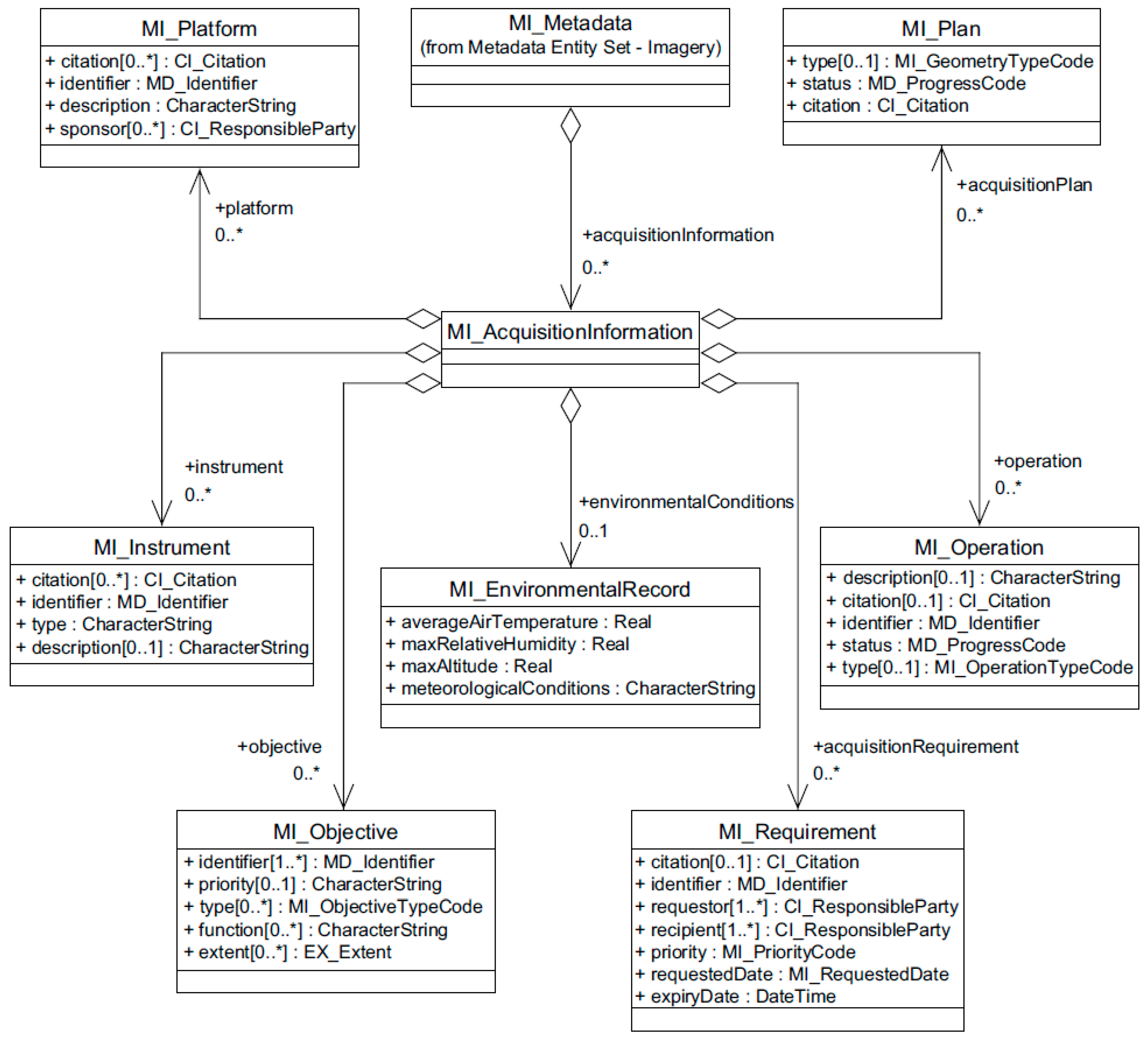
| MI_AcquisitionInformation | designations for the measuring instruments, the platform carrying them, and the mission to which the data contributes |
| MI_Metadata | root entity that defines information about acquisition and processing of geographic information (MD_Metadata extended) |
| MI_Platform | designation of the platform used to acquire the data set |
| MI_Instrument | list of events related to platform/instrument/sensor |
| MI_Sensor | specific type of instrument |
| MI_Objective | describes the characteristics, spatial and temporal extent of the intended object to be observed |
| MI_EnvironmentalRecord | information about the environmental conditions during the acquisition |
| MI_Requirement | requirement to be satisfied by the planned data acquisition |
| MI_Operation | designations for the operation used to acquire the dataset |
| MI_Plan | designations for the planning information related to meeting the data acquisition requirements |
| (a) | Minimal-Metadata-Instance requirements class (mdb) | Minimum mandatory content requirements specified by the ISO 19115-1 model for dataset metadata |
| (b) | Metadata for data or services requirements class (mds) | All properties defined by ISO 19115-1 and ISO 19115-2 models, excluding the possibility to use extended elements |
| (c) | Metadata with extended types requirements class (md1) | Extension of b) by allowing substitutions for character strings from the geospatial common extension (gcx) namespace (originally defined by ISO/TS 19139) |
| (d) | Metadata with extended content requirements class (md2) | Extension of c) to allow using the extended elements. |
| (e) | Metadata application instance requirements class (mda) | For the description of hierarchical data aggregations or collections (see ISO 19115-1:2014, 6.2) |
| (f) | Metadata for data transfer instance requirements class (mdt) | Document type implementing the metadata for data transfer model defined in ISO/TS 19139. It provides a catalogue (defined in the cat namespace) that lists the contents of a dataset aggregation described by a metadata record and allows supporting files to be associated with the aggregate or with component datasets. |
| Element | Sub-Element | Description |
|---|---|---|
| Completeness | Commission | excess data present in the dataset |
| Omission | data absent from a dataset | |
| Logical consistency | Conceptual consistency | how well a dataset adheres to the rules of its conceptual schema |
| Domain consistency | how well values adhere to their value domains | |
| Format consistency | degree to which data is stored in accordance with the claimed physical structure of the dataset | |
| Positional accuracy | Absolute or external accuracy | closeness of reported coordinate values to values accepted as or being true |
| Relative or internal accuracy | closeness of the relative positions of features within a dataset | |
| Gridded data position accuracy | closeness of a gridded data position values to values accepted as or being true | |
| Temporal accuracy | Accuracy of a time measurement | correctness of the temporal references of an item |
| Temporal consistency | correctness of ordered events or sequences | |
| Temporal validity | validity of data with respect to time | |
| Thematic accuracy | Classification correctness | comparison of the characteristics assigned to features or their attributes to a Universe of Discourse |
| Non-quantitative attribute correctness | correctness of non-quantitative attributes | |
| Quantitative attribute accuracy | accuracy of quantitative attributes | |
| Usability | Specific quality information about a dataset’s suitability for a particular application |
| Line | Component | Description |
|---|---|---|
| 1 | Name | number of missing connections due to undershoots |
| 2 | Alias | undershoots |
| 3 | Element name | topological consistency |
| 4 | Basic measure | error count |
| 5 | Definition | count of items in the dataset, within the parameter tolerance, that are mismatched due to undershoots |
| 6 | Description | − |
| 7 | Parameter | search distance from the end of a dangling line |
| 8 | Value type | Integer |
| 9 | Value structure | − |
| 10 | Source reference | − |
| 11 | Example |  Key
|
| 12 | Identifier | 23 |
| Line | Component | Description |
|---|---|---|
| 1 | Name | bias of positions (1D, 2D and 3D) |
| 2 | Alias | − |
| 3 | Element name | absolute or external accuracy |
| 4 | Basic measure | not applicable |
| 5 | Definition | bias of the positions for a set of positions where the positional uncertainties are defined as the deviation between a measured position and what is considered as the corresponding true position |
| 6 | Description | For a number of points (N), the measured positions are given as xmi, ymi and zmi coordinates depending on the dimension in which the position of the point is measured. A corresponding set of coordinates, xti, yti and zti, are considered to represent the true positions. The deviation and biases are calculated as Single deviations: Bias: A criterion for the establishing of correspondence should also be stated (e.g. allowing for correspondence to the closest position, correspondence on vertices or along lines). The criterion/criteria for finding the corresponding points shall be reported with the data quality evaluation result. |
| 7 | Parameter | − |
| 8 | Value type | Measure |
| 9 | Value structure | − |
| 10 | Source reference | − |
| 11 | Example | − |
| 12 | Identifier | 128 |
| High Level Functional Requirement | Detailed Functional Requirement |
|---|---|
| Ingestion of data | Quality control during ingestion, Ensuring well documented interface for ingestion, The necessary technology is available during this phase. |
| Storage and preservation of data | Availability for user, Preservation of the data in a way that makes the data accessible and understandable for the use in the entire lifecycle, The capability to restore archived data without loss of information, Managing the archived data. |
| Data distribution | The user can find the metadata and data of the archived data, The archive distributes data, metadata, ancillary data, calibration data, science software and documentation, Distribution of data via electronic network, Processing system to support product generation, reprocessing and in a timely manner ensure data quality Make it possible to provide a subset of the data, reproject, tools for format conversion in order to make the data holding accessible to the user in an efficient way over time, Maintain data integrity in order to satisfy external systems’ interface requirements. |
| Identifier | Title | Card | Metadata Class | Viewpoints | |||
|---|---|---|---|---|---|---|---|
| D | E | U | M | ||||
| MDSID | Metadata Set Identifier | 0..1 | DMF/Core | X | |||
| MDPTSID | Parent Metadata Set Identifier | 0..1 | DMF/Common | X | |||
| MDDLOC | Metadata Default Locale | 1 | DMF/Core | X | X | X | |
| MDTLOC | Metadata Translation | 0..* | DMF/Common | X | X | ||
| MDRPTY | Metadata Responsible Party | 1..* | DMF/Core | X | X | X | X |
| Difference | Description |
|---|---|
| Optional attributes made mandatory | The distribution format (MD_Distribution in ISO 19115) is the technology in which the data is encoded. It was only optional in ISO 19115 so for some datasets, it could be impossible to know the format that is important information, so it has been mandated in the Implementing Rules on interoperability. |
| Restrictions in codelists or features | The scope of geospatial information has been reduced to three values instead of the sixteen original values (attribute MD_ScopeCode): series identifying a geospatial dataset series; dataset identifying a geospatial dataset; service identifying a geospatial service. The hydrographic specification uses only nine of the ISO 19115 fifteen quality classes (commission, omission, conceptual consistency, positional accuracy...). Since the profile deals only with vector data, the gridded data accuracy has not been implemented. |
| Guidelines on how to populate an attribute | Since the data format is free in ISO 19115 and in the metadata Implementing Rules (a lot of formats can be used for different use cases), the Geography Markup Language (GML) has been selected as the default format for the hydrographic specification because on it uses only vector data. The INSPIRE profile has constrained the identification of contact from ISO 19115 to the use of “point of contact” to avoid discrepancies between contact types. |
| Additional rules | ISO 19115 allows identifying dataset by providing keywords for a given thesaurus. In INSPIRE, keywords have been restricted to those from the GEMET thesaurus [42]. ISO 19115 does not mandate any particular coordinate reference systems, but the hydrographic specification restricts coordinate reference systems to a list of EPSG codes in order to facilitate data interoperability. |
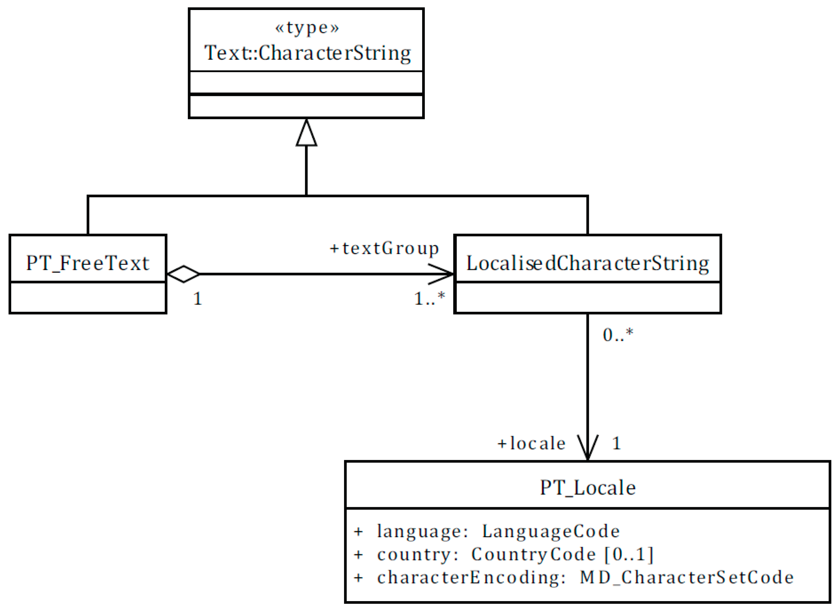
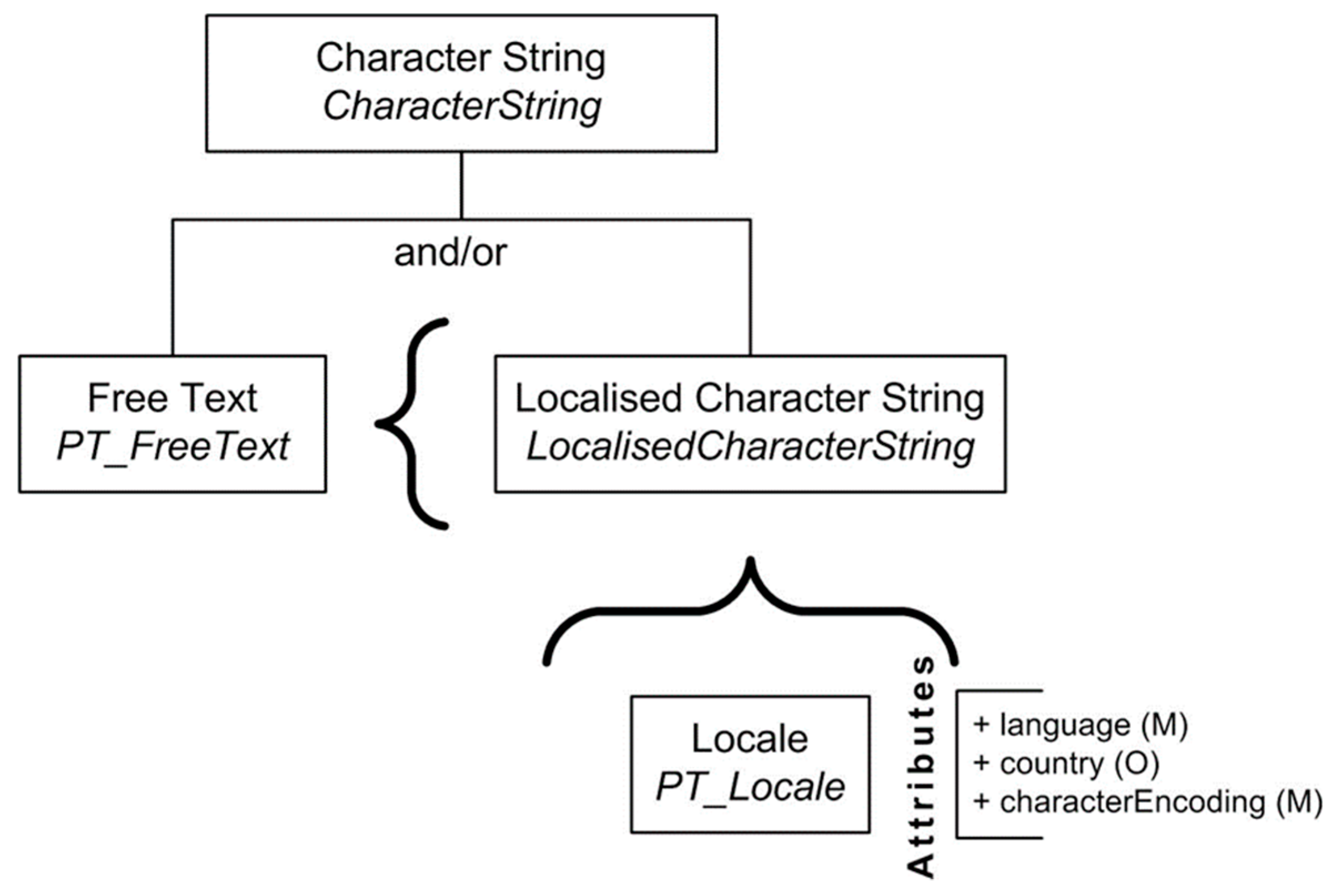
| Additional features | ISO 19115 does not allow the documentation of all languages available for a dataset. Therefore, the Metadata Implementing Rules added the attribute PT_Locale to add this capability which has also been reflected in the revision of ISO 19115 (i.e., 19115-1). |
| Name | Definition | Type |
|---|---|---|
| Subject | The topic of the content of the resource | CharacterString |
| Title | A name given to the resource | CharacterString |
| Abstract | A summary of the content of the resource | CharacterString |
| AnyText | A target for full-text search of character data types in a catalogue | CharacterString |
| Format | The physical or digital manifestation of the resource | CharacterString |
| Identifier | A unique reference to the record within the catalogue | Identifier |
| TemporalExtent | Date or period for the content being described in metadata | Date-8601 |
| Modified | Date on which the record was created or updated within the catalogue | Date-8601 |
| Type | The nature or genre of the content of the resource. Type can include general categories, genres or aggregation levels of content. | CodeList |
| BoundingBox | A bounding box for identifying a geographic area of interest | BoundingBox |
| CRS | Geographic Coordinate Reference System (Authority and ID) for the BoundingBox | Identifier |
| Association | Complete statement of a one-to-one relationship | Association |
| Dublin Core Element Name | Term Used in OGC Queryables | Definition | Type |
|---|---|---|---|
| title | Title | A name given to the resource. Also known as “Name”. | CharacterString |
| creator | An entity primarily responsible for making the content of the resource. | CharacterString | |
| subject | Subject | A topic of the content of the resource. This is a place where a Topic Category or other taxonomy could be applied. | CharacterString |
| description | Abstract | An account of the content of the resource. This is also known as the “Abstract” in other aspects of OGC, FGDC, and ISO metadata. | CharacterString |
| publisher | An entity responsible for making the resource available. This would equate to the Distributor in ISO and FGDC metadata. | CharacterString | |
| contributor | An entity responsible for making contributions to the content of the resource. | CharacterString | |
| date | Modified | The date of a creation or update event of the catalogue record. | ISO-8601 date |
| type | Type | The nature or genre of the content of the resource. | CodeList |
| format | Format | The physical or digital manifestation of the resource. | CharacterString |
| identifier | Identifier | A unique reference to the record within the catalogue. | Identifier |
| source | Source | A reference to the full metadata from which the present resource is derived. | URI |
| language | A language of the intellectual content of the catalogue record. | CharacterString | |
| relation | Association | The name of the relationship that exists between the resource described by this record and a related resource | |
| coverage | BoundingBox | The spatial and temporal extent or scope of the content of the resource. | Extent |
| rights | Information about rights held in and over the resource. | CharacterString |
© 2019 by the authors. Licensee MDPI, Basel, Switzerland. This article is an open access article distributed under the terms and conditions of the Creative Commons Attribution (CC BY) license (http://creativecommons.org/licenses/by/4.0/).
Share and Cite
Brodeur, J.; Coetzee, S.; Danko, D.; Garcia, S.; Hjelmager, J. Geographic Information Metadata—An Outlook from the International Standardization Perspective. ISPRS Int. J. Geo-Inf. 2019, 8, 280. https://0-doi-org.brum.beds.ac.uk/10.3390/ijgi8060280
Brodeur J, Coetzee S, Danko D, Garcia S, Hjelmager J. Geographic Information Metadata—An Outlook from the International Standardization Perspective. ISPRS International Journal of Geo-Information. 2019; 8(6):280. https://0-doi-org.brum.beds.ac.uk/10.3390/ijgi8060280
Chicago/Turabian StyleBrodeur, Jean, Serena Coetzee, David Danko, Stéphane Garcia, and Jan Hjelmager. 2019. "Geographic Information Metadata—An Outlook from the International Standardization Perspective" ISPRS International Journal of Geo-Information 8, no. 6: 280. https://0-doi-org.brum.beds.ac.uk/10.3390/ijgi8060280