Article

HBIM Modeling from the Surface Mesh and Its Extended Capability of Knowledge Representation

1
Photogrammetry and Geomatics Group, ICube Laboratory UMR 7357, INSA Strasbourg, 67000 Strasbourg, France
2
Department of Architecture, China University of Technology, Taipei 116, Taiwan
*
Author to whom correspondence should be addressed.
ISPRS Int. J. Geo-Inf. 2019, 8(7), 301; https://0-doi-org.brum.beds.ac.uk/10.3390/ijgi8070301
Submission received: 7 July 2019 / Accepted: 12 July 2019 / Published: 15 July 2019
(This article belongs to the Special Issue BIM for Cultural Heritage (HBIM))

Abstract

:
Built heritage has been documented by reality-based modeling for geometric description and by ontology for knowledge management. The current challenge still involves the extraction of geometric primitives and the establishment of their connection to heterogeneous knowledge. As a recently developed 3D information modeling environment, building information modeling (BIM) entails both graphical and non-graphical aspects of the entire building, which has been increasingly applied to heritage documentation and generates a new issue of heritage/historic BIM (HBIM). However, HBIM needs to additionally deal with the heterogeneity of geometric shape and semantic knowledge of the heritage object. This paper developed a new mesh-to-HBIM modeling workflow and an integrated BIM management system to connect HBIM elements and historical knowledge. Using the St-Pierre-le-Jeune Church, Strasbourg, France as a case study, this project employs Autodesk Revit as a BIM environment and Dynamo, a built-in visual programming tool of Revit, to extend the new HBIM functions. The mesh-to-HBIM process segments the surface mesh, thickens the triangle mesh to 3D volume, and transfers the primitives to BIM elements. The obtained HBIM is then converted to the ontology model to enrich the heterogeneous knowledge. Finally, HBIM geometric elements and ontology semantic knowledge is joined in a unified BIM environment. By extending the capability of the BIM platform, the HBIM modeling process can be conducted in a time-saving way, and the obtained HBIM is a semantic model with object-oriented knowledge.

1. Introduction

Built heritage geometric modeling has been conducted using reality-based data [1,2,3,4]. The geometric model preserves the current shape of the heritage object, monitors eventual changes, and reconstructs them even if the historic buildings should have some critical evolutions or damages. It is no longer a problem to obtain an accurate 3D geometric model, yet it is still highly anticipated to perform semantic segmentation and labeling of elements [5,6,7], and to improve the representation of the relationships between tangible and intangible heritage information [8].
With the trend of information technology, building information modeling (BIM) has been widely developed to manage the geometry, semantic, attribute, energy, and relationship information. BIM is initially created to design and manage the life-cycle construction of new buildings. Further, BIM platforms are increasingly supportive of 3D point clouds representing the entity surface. Subsequently, a new concept of as-built BIM begins to recreate and manage existing buildings [9], and the modeling from point clouds in the BIM environment has produced advancements in a scan-to-BIM process [10]. By importing the point clouds into the BIM software, the building components can be created using the existing BIM Industry Foundation Classes (IFC) classes and self-defined structures. In this kind of information models, the representation of the building is not only a coherent geometrical modeling of the reality but also contains additional details typical of semantic, parametric, and relationship descriptions of its elements.
BIM draws attention from the field of heritage documentation and conservation [11,12,13] and has generated a new issue of heritage/historic building information modeling (HBIM) [14]. HBIM can either utilize the BIM concept to re-create “new” heritage according to the historical documentation or use the “as-built” BIM concept to map HBIM volume objects to the reality-based surface model [15]. The HBIM model is no longer just a virtual representation and geometric reconstruction of heritage, but the sub-elements have become advanced objects with rich information, including the quantitative and qualitative description and strict relationship information.
Built heritage is characterized by heterogeneity in both aspects of geometry and semantics. Such heterogeneity of HBIM brings new challenges to the usual sense of BIM, considering the complex geometric structures and knowledge composing heritage. On the one hand, the irregular and unique structures forming the historic buildings make HBIM extraordinary and complicated compared to classical BIM modeling and models [16]. Currently, most research groups aim to address these irregular shapes in the HBIM modeling process. Virtual Historic Dublin led by Murphy [12,14,17] constructed the irregular structures of HBIM through geometric description language (GDL). GDL is used to build parametric elements regarding the historic building based on documentation. These parametric elements are then mapped to the reality-based data, and their parameters are optimized to obtain a current-state diagnosis. López et al. [18] drew the reference lines and rules by analyzing bibliographic data to help the manual design of the HBIM model. Barazzetti et al. [19,20,21] relied on non-uniform rational basis splines (NURBS) curves to preserves the details of complex structures in the BIM-based reconstruction from a point cloud. Garagnani [22,23] developed a plug-in named GreenSpider to produce the parametric HBIM elements, which imports vertexes of interest of the point cloud and then creates accurate components based on these discrete, selectable snap points.
On the other hand, some consider the difficulties of HBIM in representing and managing the vast and complicated knowledge related to non-geometrical aspects of the heritage. The integration of HBIM with ontologies becomes popular to extend the capabilities of HBIM in knowledge management and conservation. Pauwels et al. [24,25] developed an automatic EXPRESS-to-OWL tool that converts the HBIM IFC model to ifcOWL ontology. Simeone, Cursi et al. [26,27,28] focused on the development of a semantic-enriched HBIM that integrates HBIM and a knowledge base through ontologies as a way to enhance knowledge representation and management.
The main contributions of this paper involve two aspects to deal with these two kinds of challenges as well. A new mesh-to-HBIM workflow is proposed in the modeling process, which transfers the holistic surface mesh to semantic HBIM model with reduced human involvement. Also, integration of obtained HBIM and ontology is explored with the capability of representation of a large amount of semantics, which combines the HBIM elements and historical knowledge in a unified BIM environment.

2. State of the Art

2.1. Scan-to-HBIM and Mesh-to-HBIM

Currently, HBIM modeling is generally as-built HBIM models for existing built heritage generated by the scan-to-HBIM workflows. The scan-to-HBIM mainly consists of two kinds of approaches, forward modeling and reverse modeling according to whether simulated primitives are predicted on the reference of historical documentation or not.
On the one hand, the forward design combines both the original HBIM concept from historical documentation and as-built HBIM concept from reality-based data [12,19,29,30,31]. The parametric components composing heritage are first simulated based on the prior knowledge about the parameters and rules and try to predict what shape the building might be. Then the simulated primitives are mapped to the 3D point cloud space where to refine the parameters and obtain a current-state diagnosis. So the process depends on how to fit the standard shapes of HBIM components into the reality-based point clouds, which can be addressed via manual interpretation and possible shape-based recognition [32].
On the other hand, reverse design directly creates the parametric primitives in the BIM platform according to the point clouds and other formats (such as surface mesh and solid) derived from the point clouds. This kind of approach is active and attractive in the process of scan-to-BIM, such as the automated/semi-automated algorithms proposed in [7,33,34]. Those studies dealt well with planar walls and floors and some other regular structures (i.e., rectangular openings and cylinder columns). Current scan-to-HBIM remains mostly a manual process even though there are some commercial tools to help the scan-to-(H)BIM process, such as ClearEdge3D Edgewise, IMAGINit Scan to BIM, Pointsense, and Leica CloudWorx [18,35,36,37,38]. Some also have tried to develop the plugins for the specific heritage structures; for example, some Autodesk Revit API plugins were designed to create HBIM elements according to the sparse points which generally consider simple structures such as rectangular beam frame [39] and columns [22].
Moreover, most BIM software is not 3D-centric and does not exhibit the functions of freeform geometry modeler. They create the 3D model based on the rotation and extrusion of the predefined position in the 2D plane. The freeform design of users is limited when creating complex geometry in a 3D point cloud space directly. Thus, a key challenge today is to reduce the human involvement leading to as-built HBIM from point clouds [33] and reserve the geometric accuracy for irregular details during its translation into BIM objects [21,37].
A surface mesh can accurately represent the irregular shapes of architectural heritage and their as-built conditions, but it is rarely managed in a BIM environment [40]. Recently, HBIM modeling from mesh draws attention, and several works have mentioned the possibility to create HBIM models from surface mesh and solid geometry instead of point clouds. Some have converted the solid mesh into 3D solid primitives and then assembled these components to the HBIM model directly in the BIM software [35,41,42]. In [43], HBIM is constructed with three types of primitives and data sources, including point clouds, closed mesh, and CAD/.3dm components. Reference [44] explored the potential to import surface mesh representing complex objects into BIM software to serve as the reference for creating the parametric elements.
In this paper, a mesh-to-HBIM workflow is developed, consisting of two steps: (i) Segmentation of surface mesh and generation of 3D volume primitives, and (ii) semantic HBIM modeling according to the solid primitives. The proposed approach is conducted in a semi-automated way without human drawing and deals with irregular shapes by NURBS. The obtained HBIM model is composed of BIM semantic elements, which are not defined with specific geometric parameters yet can be attached with the additional semantic, attribute, and relationship information.

2.2. HBIM and Ontology
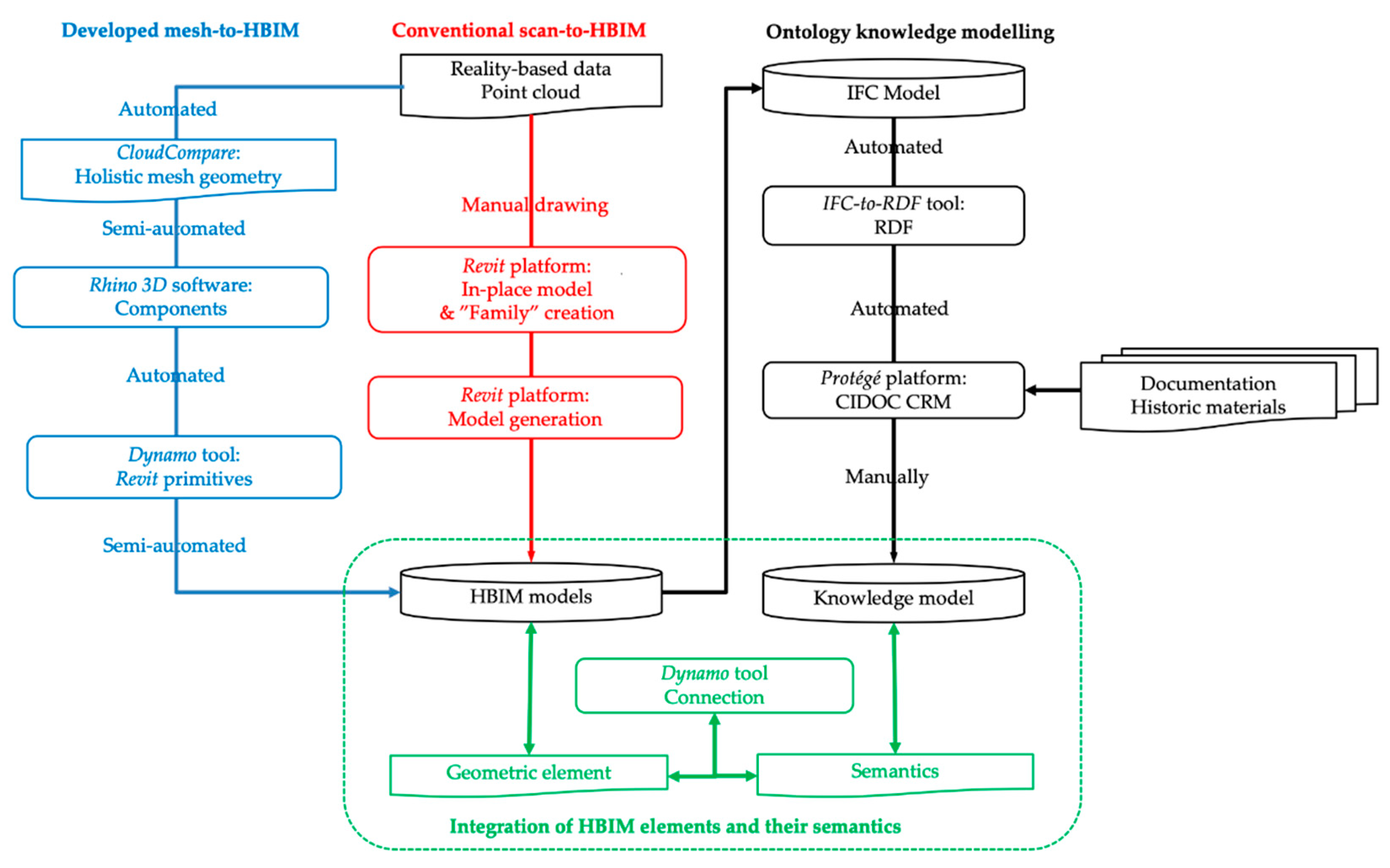
Compared to the conventional geometric models, the HBIM model provides a unified environment for semantic/parametric elements, 2D/3D visualization and spatial/attribute database. But HBIM is still challenging in managing a large volume of semantics; for example, historical context, social information, environmental resources [8]. Despite this, extremely heterogeneous knowledge is an essential asset for built heritage.
An ontology can serve as a data collector of all the semantics of entity to build a knowledge model, which is generally called a domain representing its primary entities (domain objects), the relations between them, the attributes (called properties) of these entities, and their values [27,45,46,47]. Previous studies show that ontology can overcome some limitations of the current BIM IFC data model. For example, Jung and Joo [48] indicated using ontology in BIM framework to automate spatial and temporal interrelationship. Abanda et al. [49] combined ontologies with a BIM model to facilitate information extraction for cost estimation application, in which ontology is employed to check the semantics and reason the descriptive logic. Ali and Mohamed [50] encoded a BIM model using resource description framework (RDF) and then grouped the objects into clusters representing different trades. Zhang and Issa [51] integrated BIM with ontology to generate partial BIM models based on queries.
Ontologies are increasingly used to overcome the barriers to heterogeneous semantic data sharing and integration about cultural heritage. Several advantages of ontology semantics in built heritage include: (i) Homogenous representation and management of all the knowledge related to heritage, (ii) sharing in a scientific community, and (iii) knowledge reasoning and analyzing. Ontologies play significant roles in connection with HBIM to extend the capability of HBIM in the aspect of knowledge representation and management [8,52,53]. Currently, the combination of ontology semantics and HBIM geometric elements can be conducted in different environments: (i) BIM platform (typically as Autodesk Revit) by direct BIM ad-hoc development and DB Link to connect to external database [45], (ii) ontology platform by migrating HBIM IFC files to ontology format [25], and (iii) a newly developed unified platform [27].
In this paper, we connect the HBIM geometric elements and ontology semantics in a unified BIM environment. The proposed approach consists of two steps: (i) Migrating HBIM IFC files to ontology platform to enrich the semantic information, and (ii) connecting the HBIM element with semantics in the BIM environment.

3. Methodology

The methodology consists of HBIM modeling and knowledge enrichment. A parametric HBIM model is obtained from the point clouds and conventional scan-to-HBIM process (the red part in Figure 1), while a semantic HBIM model is created from the surface mesh and proposed mesh-to-HBIM workflow (the blue section in Figure 1). For the scan-to-HBIM process, we manually draw the parametric HBIM elements (i.e., columns, roof, slabs, and walls) in the BIM platform (Autodesk Revit in the study) on the reference of point clouds. For the mesh-to-HBIM process, we first extract the basic primitives from surface mesh (with the help of Rhino 3D in the study) and then translate the solid geometry into semantic HBIM elements (Autodesk Revit and Dynamo in the research). Furthermore, the obtained HBIM models are extended with the capability of representation of heterogeneous knowledge by ontology semantic richness. The HBIM IFC model can be converted to ontology RDF model with consistent entities, and then semantics describing heritage can be enriched under ontology rules (the black part in Figure 1). Finally, the HBIM geometric element and ontology knowledge is connected in a unified BIM environment via Revit Dynamo tools (the green section in Figure 1).
Autodesk Revit, a common BIM platform, provides friendly support of point clouds and becomes a hot as-built HBIM modeling environment [18,19,22,37,54]. Autodesk Revit also includes a built-in Dynamo visual programming tool to extend the BIM capabilities [42,55,56,57,58]. Autodesk Dynamo is an open-source visual programming environment, which offers designers the ability to design and manipulate BIM elements by programming interactively. This project utilized Dynamo to extend the capability of Revit BIM environment by integration with conventional geometric models (such as from Rhino 3D and SketchUp) and ontology/database knowledge description.

3.1. Study Area

The St-Pierre-le-Jeune Church, Strasbourg, France, was built between 1889 and 1893 and designed by German architects Skjold Neckelmann and August Hartel. The church is in the neo-Romanesque style, with its imposing 50 m dome inside and a diameter close to 20 m at the base. Our previous project [59,60] took in total 2755 UAV images and around 200 terrestrial images for the exterior and generated the point clouds based on dense matching. The meshing was then performed on the merged point cloud using the Poisson method (level of Octree 13). Finally, the textures from all images were projected on the unified 3D mesh. The final 3D model is a holistic geometric model in mesh surface format, which can be viewed through the following link: https://skfb.ly/PtQF [60]. The study area in this paper is the front part of the church, including the main façade and two square belfries (Figure 2).

3.2. HBIM Environment for Semantic Modeling and Knowledge Management

Both HBIM and ontology utilize the object-oriented approach consisting of a primitive system to describe the characteristics of built heritage elements as well as their relationships. They represent heritage through a synthesis of three main concepts: “Classes”, “properties”, and “rules/relationships”. A “class” is a group of elements with a standard set of parameters and similar representation, which is the base for the HBIM modeling, ontology semantics richness, and information fusion. That is, HBIM and ontology rely on corresponding “classes” and entities with different types of properties and relationships.
In the study, the “classes” and entities are first created as geometric HBIM elements, then enriched with semantic knowledge in ontology platform, and merged in a unified BIM environment. Thus, the “classes” and entities are described by two different kinds of details:
(i) HBIM elements: The library of parametric “classes” needs to be built to define the structural components of the historic building. Then the instances can be created by tuning parameters (such as shape, size, and other properties) of the general “class”, and they can be linked together with strict spatial relationships. The spatial relationships are fixed, even if the sizes or shapes of the elements change.
(ii) Ontological knowledge: The “classes” and entities are converted from the HBIM elements with unique identifiers. The knowledge related to the historic building and its sub-elements can be enriched by ontology properties and relationship. The ontological knowledge is finally connected with HBIM elements in the BIM environment.

3.3. Conventional Scan-to-HBIM
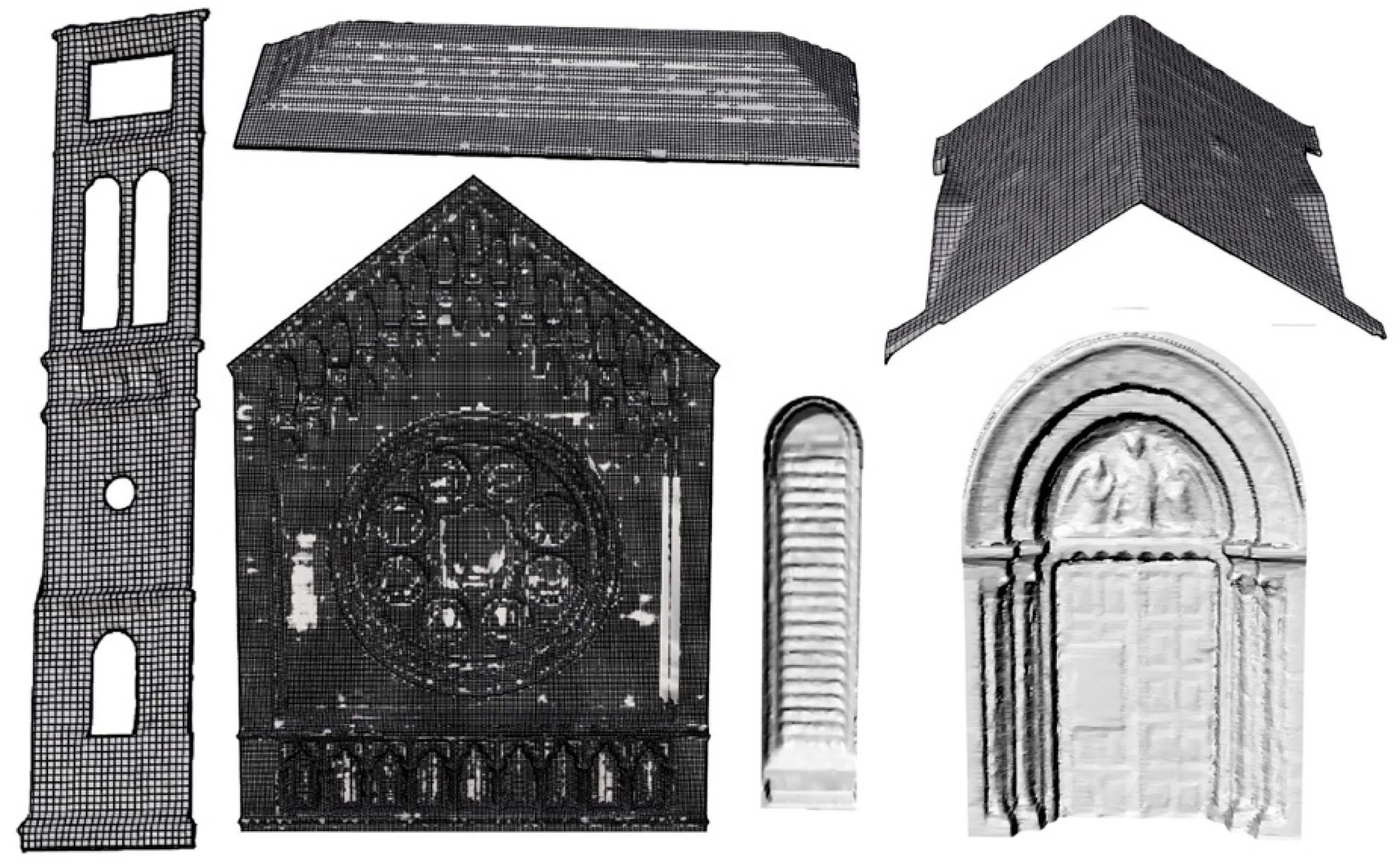
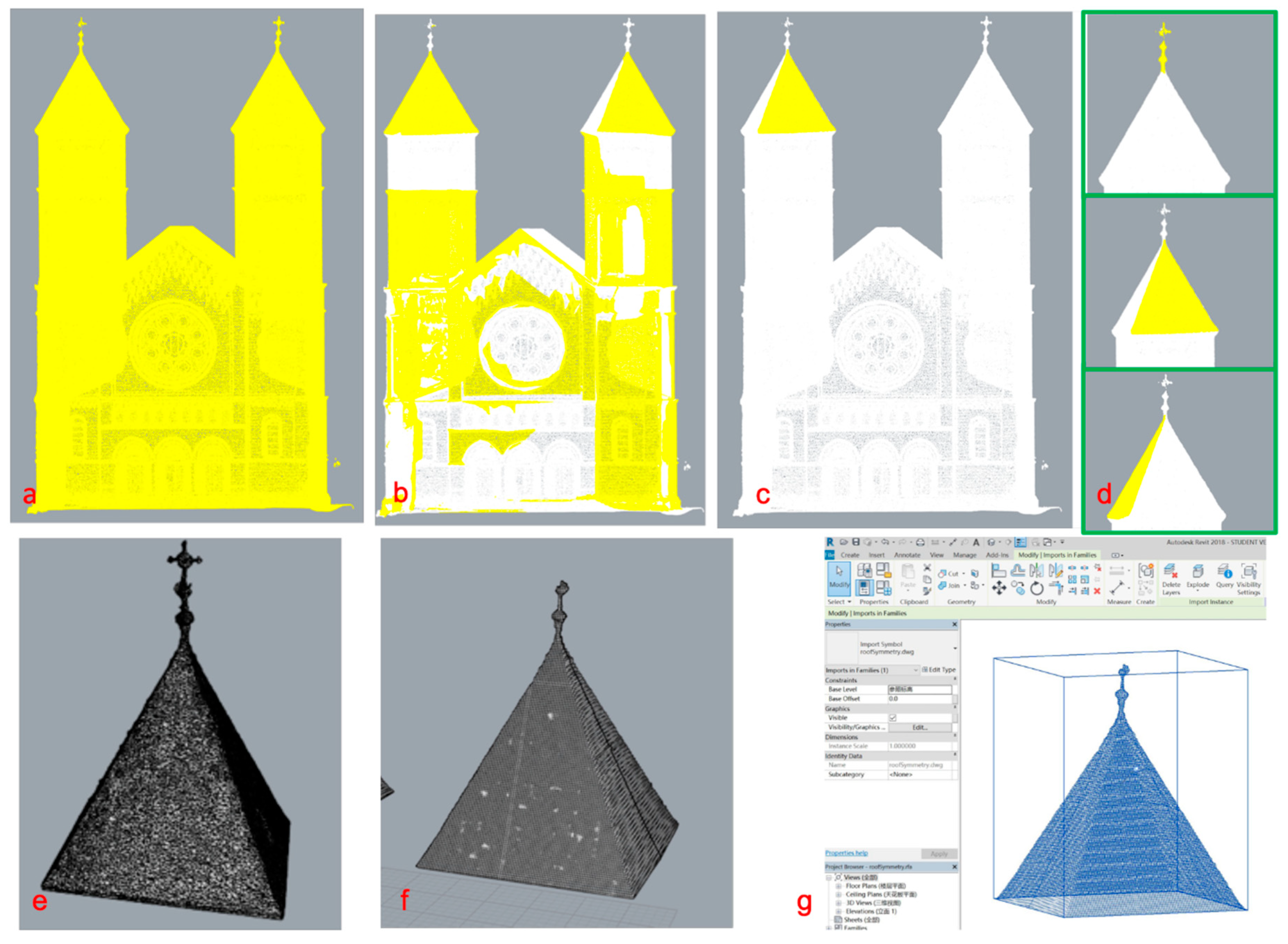
Given that many of default BIM primitives regard modern and contemporary buildings, the structures composing the heritage need to be self-defined. In the study, reverse modelling is used to create the primitives constituting the St-Pierre-le-Jeune Church directly. The clean point cloud (Figure 3a) is loaded into the BIM platform to provide the reference of geometric shapes. Instead of point cloud segmentation, manual design of the basic shapes composing heritage is conducted by visual interpretation. Figure 3c shows some typical BIM primitives whose parameters and shapes are determined by the point cloud. The final stage is the mapping of BIM objects onto the 3D surface model. The semantic HBIM model (Figure 3b) is created by assembling these primitives whose position is defined by point cloud as well.
However, BIM platform is initially developed for new buildings, which builds the 3D models according to rules and parameters. Also, BIM software (including Autodesk Revit adopted in the study) is not a 3D-centric and a freeform geometry modeler. They mostly create the 3D model based on the rotation and extrusion of the predefined 2D shape in the plane. Thus, the manual drawing of scan-to-HBIM is time-consuming because the direct modeling in 3D point cloud space is not accordant with the design concept of BIM.

3.4. Mesh-to-HBIM

The above self-defined primitives from point clouds are parametric “classes” composing a historic building, whose shape can be altered and refined later. BIM platform also supports another kind of non-changeable primitives, which can also attach properties; except their geometric shape cannot be further modified. These primitives are generally derived from the existing solid geometry. The point clouds representing the regular shape can be translated into simple solid meshes through low-poly meshes [9,19]. But it is worth to transfer the point clouds into triangulated mesh before converting into a solid element when dealing with surfaces that are irregular and strongly deformed [41].
The proposed mesh-to-HBIM process aims to transfer the holistic surface mesh to volume semantic HBIM. The original triangulated mesh is the accurate fitting of the point clouds and reconstructs heritage using 3D surface, whereas HBIM is dedicated to a 3D solid element and cannot support the unclosed surface mesh. The process, therefore, mainly consists of three steps: Primitive extraction based on multi-layered segmentation in Rhino 3D, a transformation from surface element to a volume component using extrusion and NURBS functions in Rhino 3D, and generation of BIM component using Revit Dynamo packages.
(1) Segmentation of Holistic Mesh
The holistic mesh is fundamentally segmented into parts representing the church (i.e., walls, roofs, and windows). There have been lots of platforms to segment and edit 3D triangulated meshes, and Rhino 3D, a solid modeling software with powerful mesh processing functions, is adopted in the project. The “Explode” command in Rhino 3D is used to break the holistic mesh down into small patches. The “Explode” command can be conducted iteratively until the scale of the patches is small enough. Then, the users can call the “Join” command to connect patches to form a single object. Taking the roof structure as an example (Figure 4), the roof consists of several patches (yellow parts), and the patch needs further explosion if it involves non-roof structures.
(2) Faces to Solid
These 3D elements are still in 3D surface mesh format (Figure 4e) and need to be transferred to solid primitives considering that HBIM is a volume model. Meshes represent 3D surfaces as a series of discreet facets and yield a large file size with small enough facets to smoothly describe the irregular shapes. The “MeshToNurb” command in Rhino 3D is used to refine these triangulated meshes to NURBS surfaces, which are the mathematical representations of the surfaces with reduced file size. Then, the surfaces are extruded to solid primitives (Figure 4f) using “offset surface” command with a thickness parameter.
(3) HBIM Components
The solid elements (Figure 5) are finally imported into the BIM environment where additional characteristics are attached to each element. Spring Node, an open source Dynamo package to interact between a solid element and Revit BIM “class” and entity, is used to translate the volume element to the BIM environment (Figure 4g). This kind of HBIM components can attach attribute and material information, but their geometric shape cannot be modified in the BIM environment.

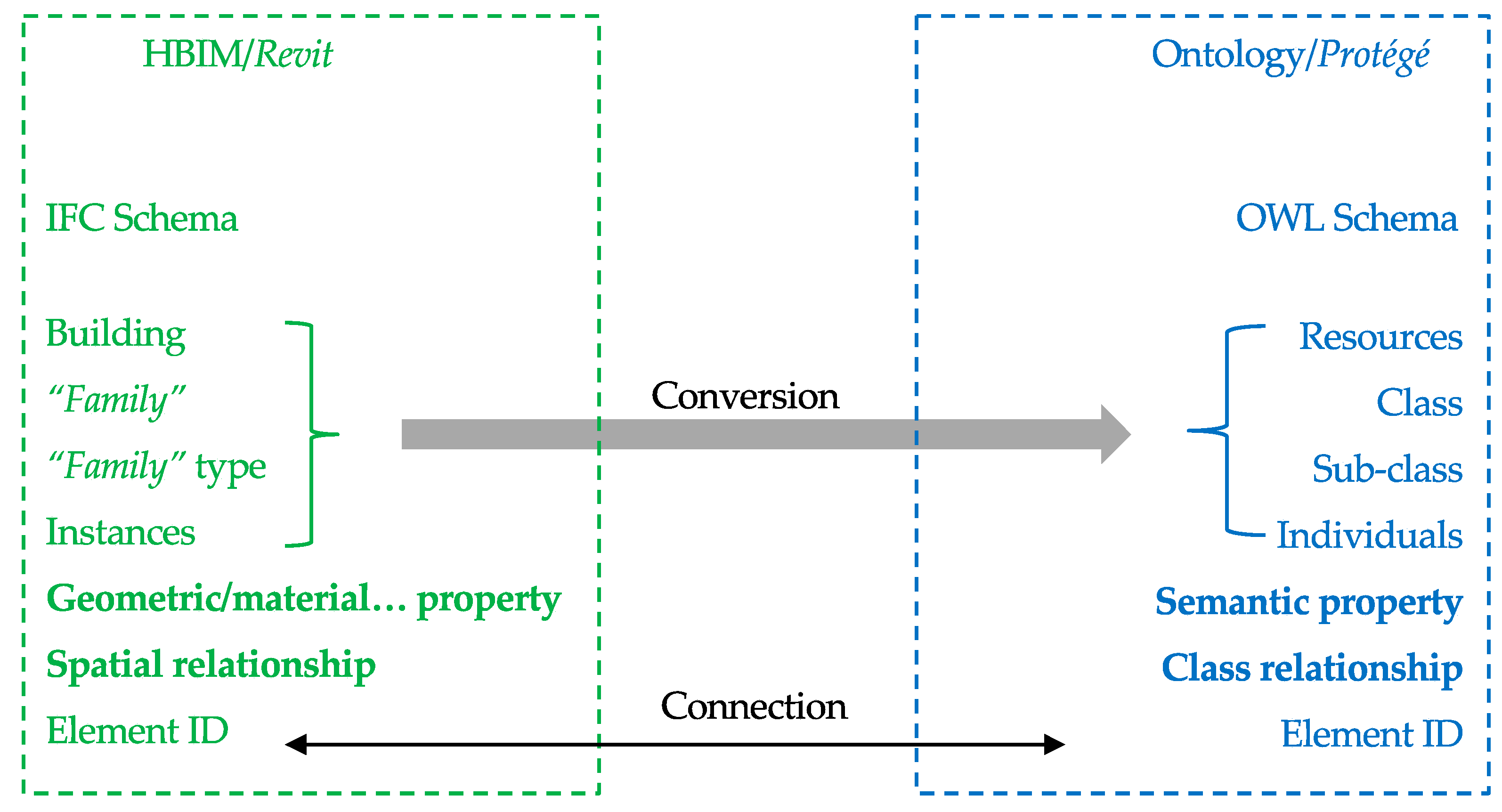
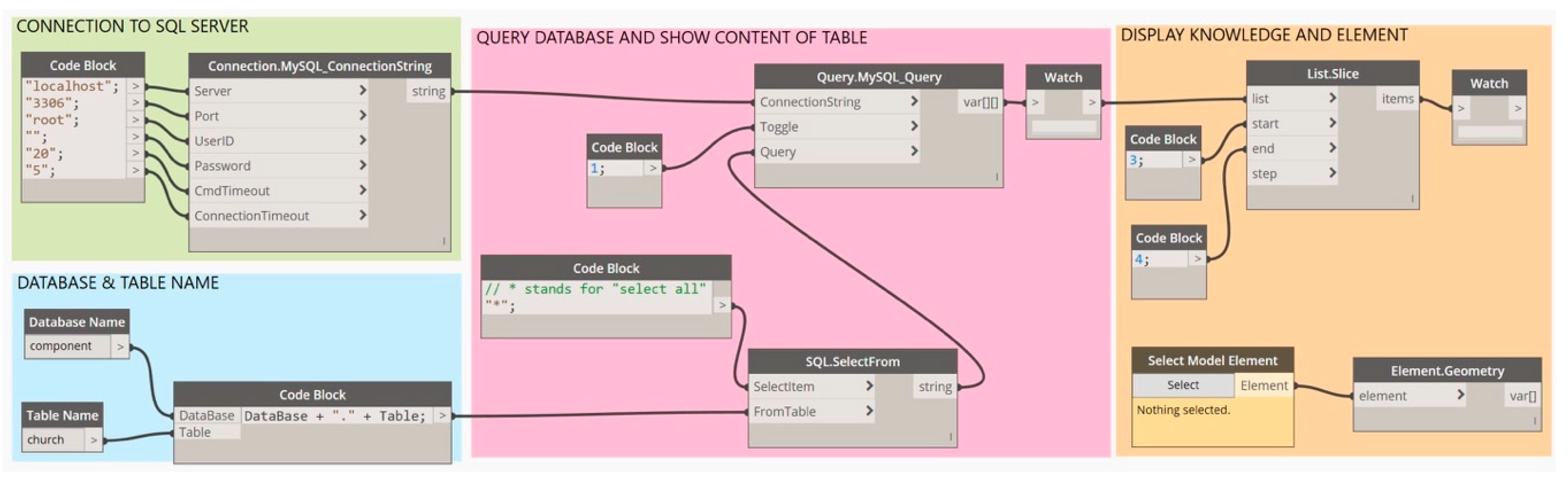
3.5. HBIM with an Extended Capability of Knowledge Representation

The similar object-oriented fashion to the modeling of the architectural object makes it possible to connect the databases between an ontology-based system and HBIM. Consequently, this connection was established by assigning the same identifier to both the representations of the corresponding entity in the two modeling environments (Figure 6). The research aims to extend the HBIM capability of attaching heterogeneous knowledge. Instead of the separate creation of HBIM and ontology model, an interactive way consisting of the transformation, richness, and combination is introduced based on the unique IDs of elements.
(1) Transformation
Currently, several BIM IFC to ontology RDF/OWL conversion procedures has been proposed. Among them, an IFC-to-RDF conversion tool developed by Pauwels and Terkaj [61] can automatically map IFC extensible properties to RDF data according to the IfcOWL ontology. Once the HBIM model has been built in a BIM environment, the geometric element based model is straightforwardly exported to IFC format and transferred to the ontology RDF format by using IFC-to-RDF conversion tool. After the transformation, the general “classes” and individual entities are reserved with the unique identifier (IDs).
(2) Knowledge Richness
Protégé, an open resource platform to construct domain models and knowledge-based applications with ontologies [62], is adopted to enrich the properties and relationships for the HBIM entities. In the cultural heritage context, the International Committee for Documentation Conceptual Reference Model (CIDOC CRM) provides ISO standardized definitions as well as a leading ontological reference for describing the implicit and explicit concepts and relationships about historic buildings [46]. To align our work with a bounder research community effort, we build the ontology model in the context of CIDOC CRM (Figure 7). Data properties in ontology represent attributes and object properties represent the relationship between different classes (Figure 8).
(3) HBIM Expansion
The drawbacks of the ontology analysis come to the requiring of long SPARQL queries to extract relevant information [63] and the accessing of the HBIM element. Thus, a correspondence between the HBIM element and ontology semantics is built in the BIM environment. Revit Dynamo provides the interactive interface in the study, where users can browse the semantic information reserved in the ontology database and the 3D model in BIM platform at the same time (Figure 9).

4. Results and Discussion

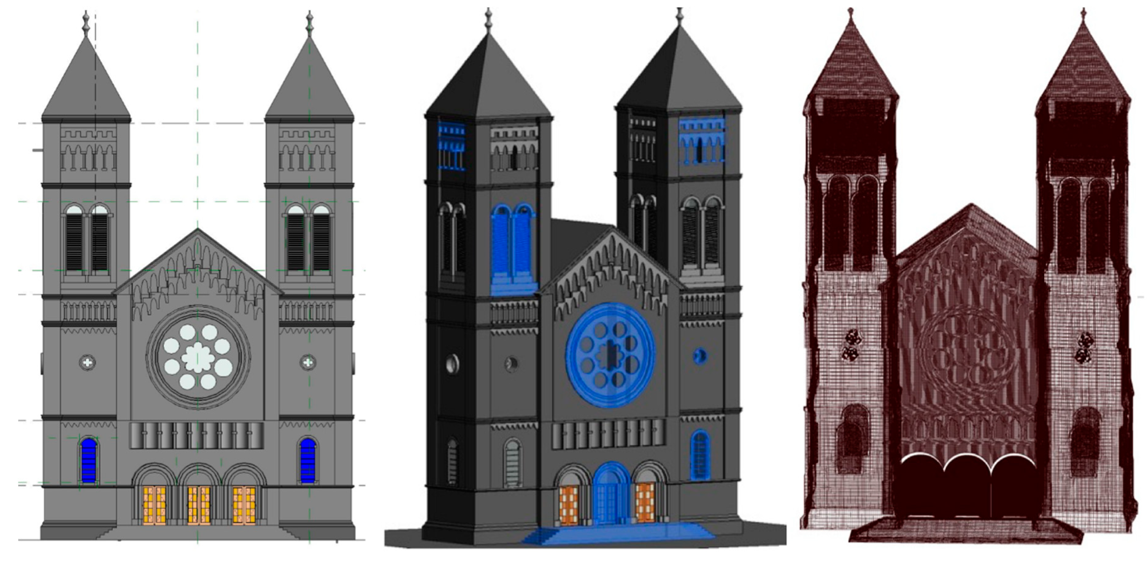
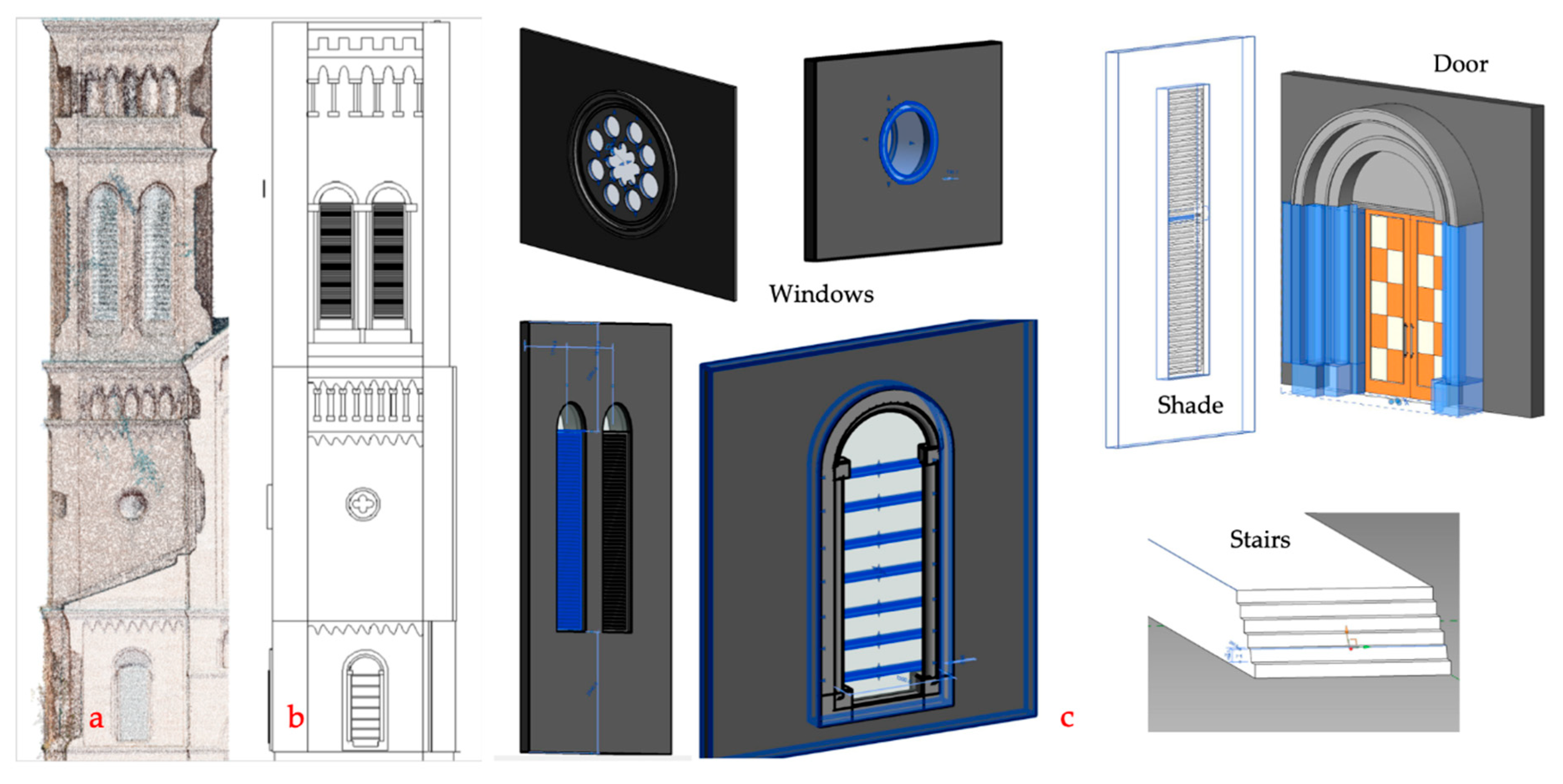
4.1. Parametric/Semantic HBIM Models

HBIM is a detailed semantic model composed of the defined “classes” and entities. In this project, three geometric models are obtained, including the holistic surface mesh model, parametric HBIM model from point clouds, and semantic HBIM model from the mesh. Compared to the holistic surface mesh, the HBIM are semantic volume models with attached properties (Table 1). Two types of BIM “classes” and HBIM models are obtained: (i) The parametric “classes” and entities consisting of a set of geometric rules and properties generate the parametric HBIM from the point clouds, while (ii) the non-changeable “classes” and entities with fixed shape generate the semantic HBIM from the surface mesh.
The obtained HBIM model (Figure 10 left) using point clouds is a geometric model with parameters and semantics. Users can alter the settings in the Revit interface or Dynamo nodes. That is, we can change the shape of the HBIM elements, and the geometric accuracy of the model extremely depends on the manual drawing works. The level of detail (LoD) of the HBIM model relies on the design of “classes” and entities, in which the more parameters and higher accurate geometry are manually created, the higher LoD is obtained. The parametric HBIM model corresponds to the most-used LoD3 in CityGML or LoD300 in IFC, which contains the full exterior of an architectural model with complete wall and roof structures, doors and windows [64].
The obtained HBIM model (Figure 10 right) using surface mesh is a geometric model with semantics and non-editable geometric instances. The model has potential to attach attribute, material, and temporal information in the BIM platform, yet its geometric aspect information is limited to non-editable and no changeable parameters available. The geometric information of the model derives from the surface mesh without human modification. The accuracy is affected by computer performance, considering that the huge size of meshes and large scale of the building may go beyond the capabilities of the software. The detail of the model depends on the surface mesh and the transformation from the surface to solid. Here, we can notice that the central part of the façade seems to become rough. One reason comes from our reduction of the resolution. The current model is about 100 MB, which is relatively huge for Dynamo and Revit platforms.

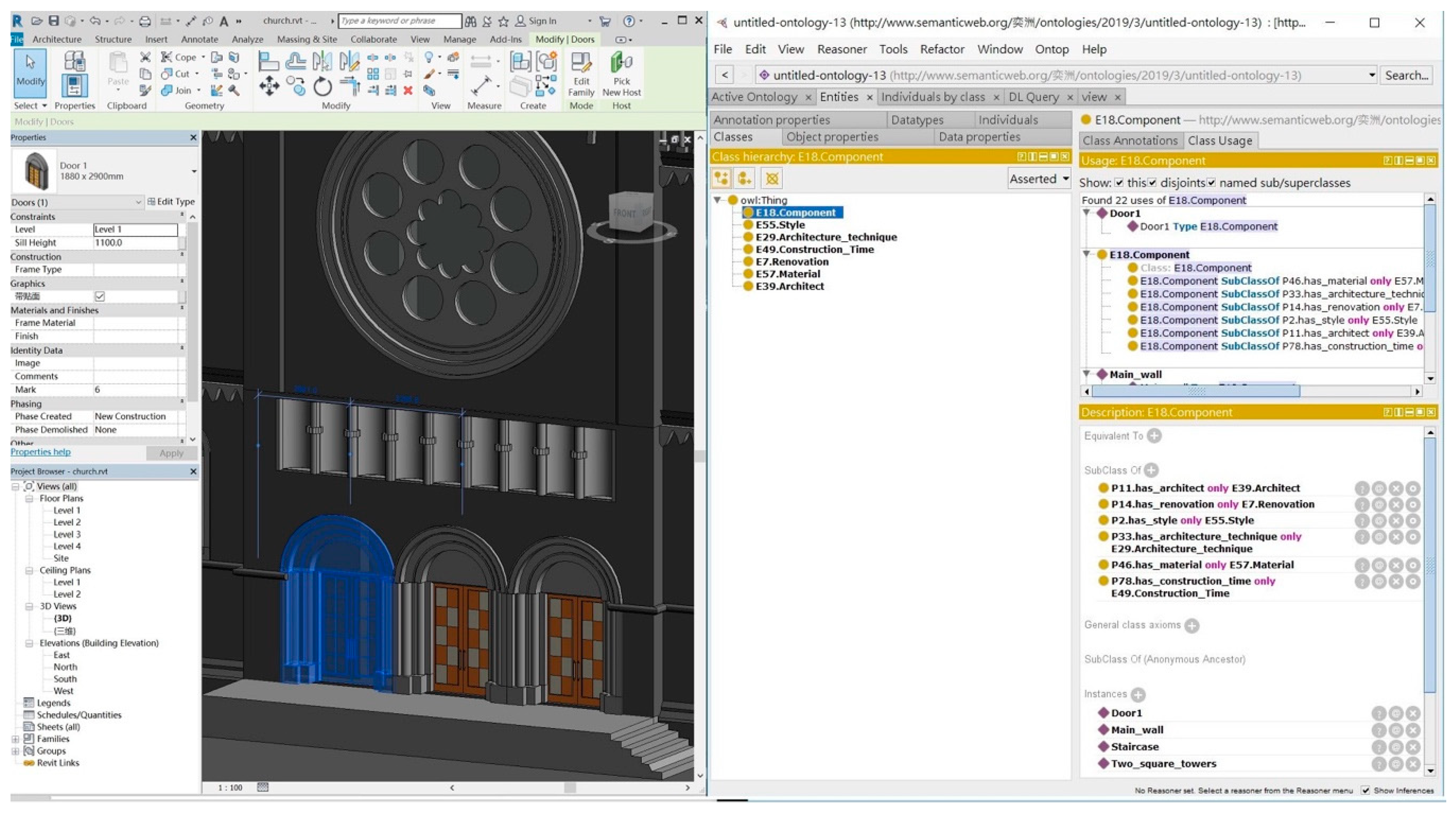
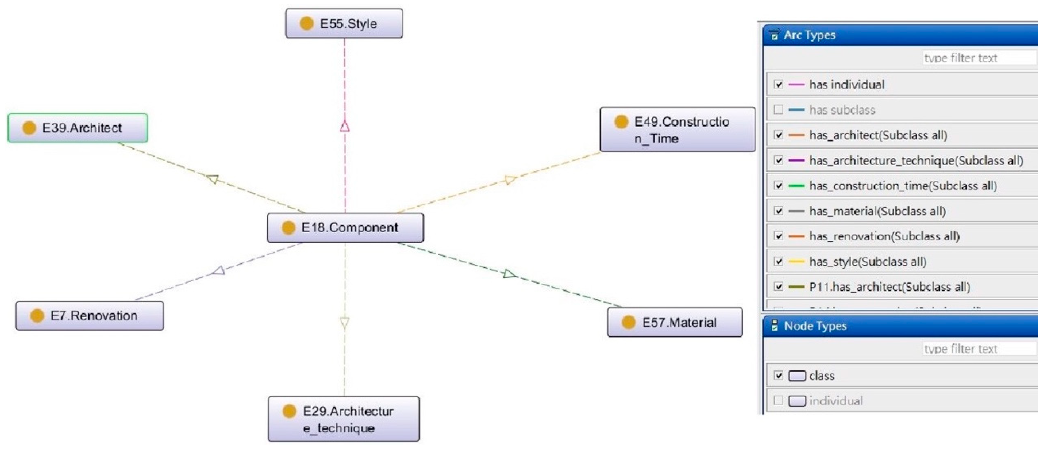
4.2. HBIM and Ontology: Geometry and Semantics

The IFC data model of parametric HBIM (via scan-to-HBIM workflow) is transferred to ontology RDF format, in which the classes and entities are reserved. An ontology model of the church is built with its historical knowledge, such as building style, architect, maintenance date. The combined entity thus includes both object-oriented information, geometric information, typically created in BIM platform, and knowledge information, usually enriched in ontology modeling systems. They are connected via the same labeling of the entity in the two modeling environments.
Revit Dynamo provides the integration platform (shown in Figure 11), where users can browse the semantic information reserved in the ontology database and the 3D model in BIM at the same time. When choosing the geometric element in Revit BIM platform, the corresponding knowledge can be displayed in the Dynamo “watch” window. The browsing result can be exported as a text file for further application.
The connection of the knowledge base and HBIM is based on the unique IDs. That is, two separate ontologies are needed to connect with scan-to-HBIM and mesh-to-HBIM, respectively. In the paper, we created a knowledge model based on scan-to-HBIM to explore the feasibility of the proposed approach. The current ontology model consists of limited historical context (such as architect, renovation time, and construction style), but the detail of the knowledge base can be further enriched in ontology environment according to the user’s needs. The drawback of the Dynamo environment lies in the lack of property names, which are replaced with numbering list in the “watch” window of the knowledge.

5. Conclusions

In summary, with the support of point clouds in the BIM software, the reality-based modeling of built heritage can be directly conducted in a BIM environment. The obtained object-oriented HBIM model not only achieves the parametric and semantic modeling of the geometry but also manages the attribute, material, and relationship of the elements. But the scan-to-HBIM still faces some challenges, typically including the time-consuming manual drawing of the complex shape composing heritage and the support of a large amount of knowledge related to heritage.
To deal with the heterogeneity of geometry and knowledge composing heritage, we proposed a mesh-to-HBIM and an HBIM-ontology-integration by using Revit Dynamo visual programming tools to extend BIM off-the-shelf capabilities (Autodesk Revit).
On the one hand, the mesh-to-HBIM modeling generated from holistic surface mesh reduced lots of individual efforts compared to scan-to-HBIM by time-consuming manual drawing. The obtained HBIM, however, possesses no specific geometric parameters because the automatic BIM primitive generation from surface mesh returns non-changeable solid elements. So, it depends on the users’ need. If the user prefers parametric geometry, a complete and personified “class” and entity has to be drawn manually; but if the user prefers the original mesh geometry and semantics, the mesh-to-HBIM provides a work-saving way.
On the other hand, HBIM is extended with the integration of ontology via Revit Dynamo, where users can browse the semantic information reserved in an ontology database and the 3D model in HBIM at the same time. The extended HBIM model fully represents and comprehends a historical building regarding its materials, construction components, and old memories in addition to the geometric shape.
The future work will go deeper into the mesh segmentation. The current mesh-to-HBIM process relies on the surface mesh segmentation in the Rhino 3D platform. Our ongoing work focuses on how to detect the semantic elements based on the point cloud segmentation algorithms.

Author Contributions

Conceptualization, Xiucheng Yang, Mathieu Koehl and Pierre Grussenmeyer; methodology, Xiucheng Yang; software, Xiucheng Yang and Yi-Chou Lu; data curation, Arnadi Murtiyoso; writing—original draft preparation, Xiucheng Yang; writing—review and editing, all authors; supervision, Mathieu Koehl and Pierre Grussenmeyer.

Funding

The work of X. Yang was supported by the China Scholarship Council (No. 201504490008).

Conflicts of Interest

The authors declare no conflict of interest.

References

  1. Grussenmeyer, P.; Landes, T.; Voegtle, T.; Ringle, K. Comparison methods of terrestrial laser scanning, photogrammetry and tachometry data for recording of cultural heritage buildings. Int. Arch. Photogramm. Remote Sens. Spat. Inf. Sci. 2008, XXXVI, 213–218. [Google Scholar]
  2. Rüther, H.; Chazan, M.; Schroeder, R.; Neeser, R.; Held, C.; Walker, S.J.; Matmon, A.; Horwitz, L.K. Laser scanning for conservation and research of African cultural heritage sites: The case study of Wonderwerk Cave, South Africa. J. Archaeol. Sci. 2009, 36, 1847–1856. [Google Scholar] [CrossRef]
  3. Remondino, F. Heritage recording and 3D modeling with photogrammetry and 3D scanning. Remote Sens. 2011, 3, 1104–1138. [Google Scholar] [CrossRef]
  4. Aicardi, I.; Chiabrando, F.; Maria Lingua, A.; Noardo, F. Recent trends in cultural heritage 3D survey: The photogrammetric computer vision approach. J. Cult. Herit. 2018, 32, 257–266. [Google Scholar] [CrossRef]
  5. De Luca, L. Methods, formalisms and tools for the semantic-based surveying and representation of architectural heritage. Appl. Geomatics 2011, 6, 115–139. [Google Scholar] [CrossRef]
  6. Remondino, F.; Lo Buglio, D.; Nony, N.; De Luca, L. Detailed Primitive-Based 3D Modeling of Architectural Elements. ISPRS - Int. Arch. Photogramm. Remote Sens. Spat. Inf. Sci. 2012, XXXIX-B5, 285–290. [Google Scholar] [CrossRef]
  7. Xiong, X.; Adan, A.; Akinci, B.; Huber, D. Automatic creation of semantically rich 3D building models from laser scanner data. Autom. Constr. 2013, 31, 325–337. [Google Scholar] [CrossRef] [Green Version]
  8. Quattrini, R.; Pierdicca, R.; Morbidoni, C. Knowledge-based data enrichment for HBIM: Exploring high-quality models using the semantic-web. J. Cult. Herit. 2017. [Google Scholar] [CrossRef]
  9. Tang, P.; Huber, D.; Akinci, B.; Lipman, R.; Lytle, A. Automatic reconstruction of as-built building information models from laser-scanned point clouds: A review of related techniques. Autom. Constr. 2010, 19, 829–843. [Google Scholar] [CrossRef]
  10. Adán, A.; Quintana, B.; Prieto, S.A.; Bosché, F. Scan-to-BIM for ‘secondary’ building components. Adv. Eng. Informatics 2018, 37, 119–138. [Google Scholar] [CrossRef]
  11. Fai, S.; Filippi, M.; Paliaga, S. Parametric modelling (BIM) for the documentation of vernacular construction methods: A BIM model for the commissariat building, Ottawa, Canada. ISPRS Ann. Photogramm. Remote Sens. Spat. Inf. Sci. 2013, II, 115–120. [Google Scholar] [CrossRef]
  12. Murphy, M.; McGovern, E.; Pavia, S. Historic Building Information Modelling–Adding intelligence to laser and image based surveys of European classical architecture. ISPRS J. Photogramm. Remote Sens. 2013, 76, 89–102. [Google Scholar] [CrossRef]
  13. Bianchini, C.; Nicastro, S. The definition of the level of reliability: A contribution to the transparency of historical-bim processes. Dn. Build. Inf. Model. Data Semant. 2018, 2, 46–60. [Google Scholar]
  14. Murphy, M.; McGovern, E.; Pavia, S. Historic building information modelling (HBIM). Struct. Surv. 2009, 27, 311–327. [Google Scholar] [CrossRef] [Green Version]
  15. Bianchini, C.; Inglese, C.; Ippolito, A. The role of BIM (Building Information Modeling) for representation and managing of built and historic artifacts. Disegnarecon 2016, 9, 10–11. [Google Scholar]
  16. Yang, X.; Koehl, M.; Grussenmeyer, P.; Macher, H. Complementarity of historic building information modelling and geographic information systems. In Proceedings of the International Archives of the Photogrammetry, Remote Sensing and Spatial Information Sciences, Prague, Czech Republic, 15 June 2016; Volume XLI, pp. 437–443. [Google Scholar] [CrossRef]
  17. Murphy, M.; Corns, A.; Cahill, J.; Eliashvili, K.; Chenau, A.; Pybus, C.; Shaw, R.; Devlin, G.; Deevy, A.; Truong-Hong, L. Developing historic building information modelling guidelines and procedures for architectural heritage in Ireland. Int. Arch. Photogramm. Remote Sens. Spat. Inf. Sci. 2017, XLII–2, 539–546. [Google Scholar] [CrossRef]
  18. López, F.J.; Lerones, P.M.; Llamas, J.; Gómez-García-Bermejo, J.; Zalama, E. A Framework for Using Point Cloud Data of Heritage Buildings Toward Geometry Modeling in A BIM Context: A Case Study on Santa Maria La Real De Mave Church. Int. J. Archit. Herit. 2017, 11, 965–986. [Google Scholar] [CrossRef]
  19. Barazzetti, L.; Banfi, F.; Brumana, R.; Previtali, M. Creation of Parametric BIM Objects from Point Clouds Using Nurbs. Photogramm. Rec. 2015, 30, 339–362. [Google Scholar] [CrossRef]
  20. Barazzetti, L.; Banfi, F.; Brumana, R.; Gusmeroli, G.; Previtali, M.; Schiantarelli, G. Cloud-to-BIM-to-FEM: Structural simulation with accurate historic BIM from laser scans. Simul. Model. Pract. Theory 2015, 57, 71–87. [Google Scholar] [CrossRef]
  21. Barazzetti, L. Parametric as-built model generation of complex shapes from point clouds. Adv. Eng. Informatics 2016, 30, 298–311. [Google Scholar] [CrossRef]
  22. Garagnani, S.; Manferdini, A.M. Parametric accuracy: Building information modeling process applied to the cultural heritage preservation. ISPRS - Int. Arch. Photogramm. Remote Sens. Spat. Inf. Sci. 2013, XL–5, 87–92. [Google Scholar] [CrossRef]
  23. Garagnani, S. Building Information Modeling and real world knowledge: A methodological approach to accurate semantic documentation for the built environment. In Proceedings of the Digital Heritage International Congress (DigitalHeritage), Marseille, France, 28 October–1 November 2013; pp. 489–496. [Google Scholar] [CrossRef]
  24. Pauwels, P.; Di Mascio, D. Interpreting Metadata and Ontologies of Virtual Heritage Artefacts. Int. J. Herit. Digit. Era 2014, 3, 531–555. [Google Scholar] [CrossRef]
  25. Pauwels, P.; Krijnen, T.; Terkaj, W.; Beetz, J. Enhancing the ifcOWL ontology with an alternative representation for geometric data. Autom. Constr. 2017, 80, 77–94. [Google Scholar] [CrossRef] [Green Version]
  26. Simeone, D.; Cursi, S.; Toldo, I.; Carrara, G. B ( H ) IM - Built Heritage Information Modelling. Extending BIM approach to historical and archaeological heritage representation. eCAADe 2009, 1, 613–622. [Google Scholar]
  27. Acierno, M.; Cursi, S.; Simeone, D.; Fiorani, D. Architectural heritage knowledge modelling: An ontology-based framework for conservation process. J. Cult. Herit. 2017, 24, 124–133. [Google Scholar] [CrossRef]
  28. Simeone, D.; Cursi, S.; Acierno, M. BIM semantic-enrichment for built heritage representation. Autom. Constr. 2019, 97, 122–137. [Google Scholar] [CrossRef]
  29. Fai, S.; Rafeiro, J. Establishing an Appropriate Level of Detail (LoD) for a Building Information Model (BIM)–West Block, Parliament Hill, Ottawa, Canada. ISPRS Ann. Photogramm. Remote Sens. Spat. Inf. Sci. 2014, II–5, 123–130. [Google Scholar] [CrossRef]
  30. Santagati, C.; Lo Turco, M. From structure from motion to historical building information modeling: Populating a semantic-aware library of architectural elements. J. Electron. Imaging 2016, 26, 011007. [Google Scholar] [CrossRef]
  31. Palestini, C.; Basso, A.; Graziani, L. Integrated photogrammetric survey and bim modelling for the protection of school heritage, applications on a case study. Int. Arch. Photogramm. Remote Sens. Spat. Inf. Sci. 2018, 42, 821–828. [Google Scholar] [CrossRef]
  32. Brilakis, I.; Lourakis, M.; Sacks, R.; Savarese, S.; Christodoulou, S.; Teizer, J.; Makhmalbaf, A. Toward automated generation of parametric BIMs based on hybrid video and laser scanning data. Adv. Eng. Informatics 2010, 24, 456–465. [Google Scholar] [CrossRef]
  33. Macher, H.; Landes, T.; Grussenmeyer, P. From Point Clouds to Building Information Models: 3D Semi-Automatic Reconstruction of Indoors of Existing Buildings. Appl. Sci. 2017, 7, 1030. [Google Scholar] [CrossRef]
  34. Thomson, C.; Boehm, J. Automatic geometry generation from point clouds for BIM. Remote Sens. 2015, 7, 11753–11775. [Google Scholar] [CrossRef]
  35. Antón, D.; Medjdoub, B.; Shrahily, R.; Moyano, J. Accuracy evaluation of the semi-automatic 3D modeling for historical building information models. Int. J. Archit. Herit. 2018, 12, 790–805. [Google Scholar] [CrossRef] [Green Version]
  36. Bolognesi, C.; Garagnani, S. From a point cloud survey to a mass 3D modelling: Renaissance HBIM in Poggio a Caiano. Int. Arch. Photogramm. Remote Sens. Spat. Inf. Sci. - ISPRS Arch. 2018, 42, 117–123. [Google Scholar] [CrossRef]
  37. Fryskowska, A.; Stachelek, J. A no-reference method of geometric content quality analysis of 3D models generated from laser scanning point clouds for hBIM. J. Cult. Herit. 2018. [Google Scholar] [CrossRef]
  38. Rodríguez-Moreno, C.; Reinoso-Gordo, J.F.; Rivas-Lpez, E.; Gmez-Blanco, A.; Ariza-Lpez, F.J.; Ariza-Lpez, I. From point cloud to BIM: An integrated workflow for documentation, research and modelling of architectural heritage. Surv. Rev. 2016, 50, 212–231. [Google Scholar] [CrossRef]
  39. Yang, X.; Koehl, M.; Grussenmeyer, P. Parametric modelling of as-built beam framed structure in bim environment. Int. Arch. Photogramm. Remote Sens. Spat. Inf. Sci. - ISPRS Arch. 2017, 42, 651–657. [Google Scholar] [CrossRef]
  40. Sun, Z.; Zhang, Y. Using drones and 3D modeling to survey Tibetan architectural heritage: A case study with the multi-door stupa. Sustainability 2018, 10, 2259. [Google Scholar] [CrossRef]
  41. Castagnetti, C.; Dubbini, M.; Ricci, P.C.; Rivola, R.; Giannini, M.; Capra, A. Critical issues and key points from the survey to the creation of the historical building information model: The case of santo stefano basilica. Int. Arch. Photogramm. Remote Sens. Spat. Inf. Sci. - ISPRS Arch. 2017, 42, 467–474. [Google Scholar] [CrossRef]
  42. Yang, X.; Koehl, M.; Grussenmeyer, P. Mesh-to-bim: From segmented mesh elements to bim model with limited parameters. Int. Arch. Photogramm. Remote Sens. Spat. Inf. Sci. - ISPRS Arch. 2018, 42, 1213–1218. [Google Scholar] [CrossRef]
  43. Santagati, C.; Lo Turco, M.; Garozzo, R. Reverse information modeling for historic artefacts: Towards the definition of a level of accuracy for ruined heritage. Int. Arch. Photogramm. Remote Sens. Spat. Inf. Sci. - ISPRS Arch. 2018, 42, 1007–1014. [Google Scholar] [CrossRef]
  44. Bruno, N.; Roncella, R. A restoration oriented HBIM system for cultural heritage documentation: The case study of parma cathedral. Int. Arch. Photogramm. Remote Sens. Spat. Inf. Sci. - ISPRS Arch. 2018, 42, 171–178. [Google Scholar] [CrossRef]
  45. Simeone, D.; Cursi, S.; Toldo, I.; Carrara, G. Bim and Knowledge Management for Building Heritage. Acadia 2014, 2014, 681–690. [Google Scholar]
  46. Messaoudi, T.; Véron, P.; Halin, G.; De Luca, L. An ontological model for the reality-based 3D annotation of heritage building conservation state. J. Cult. Herit. 2018, 29, 100–112. [Google Scholar] [CrossRef] [Green Version]
  47. Noardo, F. Architectural heritage semantic 3D documentation in multi-scale standard maps. J. Cult. Herit. 2018, 32, 156–165. [Google Scholar] [CrossRef]
  48. Jung, Y.; Joo, M. Building information modelling (BIM) framework for practical implementation. Autom. Constr. 2011, 20, 126–133. [Google Scholar] [CrossRef]
  49. Abanda, F.H.; Kamsu-Foguem, B.; Tah, J.H.M. BIM–New rules of measurement ontology for construction cost estimation. Eng. Sci. Technol. Int. J. 2017, 20, 443–459. [Google Scholar] [CrossRef]
  50. Ali, M.; Mohamed, Y. A method for clustering unlabeled BIM objects using entropy and TF-IDF with RDF encoding. Adv. Eng. Informatics 2017, 33, 154–163. [Google Scholar] [CrossRef]
  51. Zhang, L.; Issa, R.R.A. Ontology-based partial building information model extraction. J. Comput. Civ. Eng. 2012, 27, 576–584. [Google Scholar] [CrossRef]
  52. Simeone, D.; Cursi, S. A platform for enriching BIM representation through semantic web technologies. In Proceedings of the Joint Conference on Computing in Construction, Heraklion, Greece, 4–7 July 2017; pp. 423–430. [Google Scholar] [CrossRef]
  53. López, F.J.; Lerones, P.M.; Llamas, J.; Gómez-García-Bermejo, J.; Zalama, E. A Review of Heritage Building Information Modeling ( H-BIM ). Multimed. Tools Appl. 2018, 2, 21. [Google Scholar] [CrossRef]
  54. Oreni, D.; Brumana, R.; Della Torre, S.; Banfi, F.; Barazzetti, L.; Previtali, M. Survey turned into HBIM: The restoration and the work involved concerning the Basilica di Collemaggio after the earthquake (L’Aquila). ISPRS Ann. Photogramm. Remote Sens. Spat. Inf. Sci. 2014, II–5, 267–273. [Google Scholar] [CrossRef]
  55. Quattrini, R.; Battini, C.; Mammoli, R. Hbim to Vr. Semantic awareness and data enrichment interoperability for parametric libraries of historical architecture. Int. Arch. Photogramm. Remote Sens. Spat. Inf. Sci. - ISPRS Arch. 2018, 42, 937–943. [Google Scholar] [CrossRef]
  56. Pocobelli, D.P.; Boehm, J.; Bryan, P.; Still, J.; England, H. Building Information Models for Monitoring and Simulation Data. ISPRS TC II Mid-term Symp. “Towards Photogramm. 2020” 2018, XLII, 4–7. [Google Scholar] [CrossRef]
  57. Lu, Y.C.; Shih, T.Y.; Yen, Y.N. Research on historic BIM of built heritage in Taiwan - A case study of Huangxi Academy. Int. Arch. Photogramm. Remote Sens. Spat. Inf. Sci. - ISPRS Arch. 2018, 42, 615–622. [Google Scholar] [CrossRef]
  58. Chang, K.-M.; Dzeng, R.-J.; Wu, Y.-J. An Automated IoT Visualization BIM Platform for Decision Support in Facilities Management. Appl. Sci. 2018, 8, 1086. [Google Scholar] [CrossRef]
  59. Murtiyoso, A.; Grussenmeyer, P. Documentation of heritage buildings using close-range UAV images: Dense matching issues, comparison and case studies. Photogramm. Rec. 2017, 32, 206–229. [Google Scholar] [CrossRef]
  60. Murtiyoso, A.; Grussenmeyer, P.; Freville, T. Close range uav accurate recording and modeling of St-Pierre-Le-Jeune Neo-Romanesque church in Strasbourg (France). Int. Arch. Photogramm. Remote Sens. Spat. Inf. Sci. 2017, XLII–2, 519–526. [Google Scholar] [CrossRef]
  61. Pauwels, P.; Terkaj, W. EXPRESS to OWL for construction industry: Towards a recommendable and usable ifcOWL ontology. Autom. Constr. 2016, 63, 100–133. [Google Scholar] [CrossRef]
  62. Lin, C.J. The STG pattern–application of a “Semantic-Topological-Geometric” information conversion pattern to knowledge-based modeling in architectural conceptual design. Comput. Aided. Des. Appl. 2017, 14, 313–323. [Google Scholar] [CrossRef]
  63. Quattrini, R.; Pierdicca, R.; Morbidoni, C.; Malinverni, E.S. Conservation-oriented HBIM. The bimexplorer web tool. Int. Arch. Photogramm. Remote Sens. Spat. Inf. Sci. 2017, 42, 275–281. [Google Scholar] [CrossRef]
  64. Biljecki, F.; Ledoux, H.; Stoter, J. An improved LOD specification for 3D building models. Comput. Environ. Urban Syst. 2016, 59, 25–37. [Google Scholar] [CrossRef] [Green Version]
Figure 1. Workflows of the HBIM modeling and the integration with ontological knowledge.
Ijgi 08 00301 g001
Figure 2. The main façade (left), cleaned point clouds (middle), and mesh geometry (right) of the St-Pierre-le-Jeune Church in Strasbourg, France, built from typical Alsatian red sandstone.
Ijgi 08 00301 g002
Figure 3. (a) The point clouds imported in BIM platform, (b) the HBIM structures created by reverse design, and (c) some typical “classes” composing the church on the reference of the point cloud
Ijgi 08 00301 g003
Figure 4. The explosion processing to segment the holistic mesh (a) into small blocks by a multi-layered explosion (b,c). The primitive representing the church’s primary component is then generated based on the merging of several small blocks (d). The surface mesh (e) is converted to NURBS curve based solid geometry by adding thickness (f) and translated in a BIM environment (g).
Ijgi 08 00301 g004
Figure 5. The segmentation, combination and extrusion process to transfer the holistic surface mesh into individual solid elements
Ijgi 08 00301 g005
Figure 6. The correspondence between HBIM and ontology.
Ijgi 08 00301 g006
Figure 7. Ontological knowledge modeling for the HBIM entities within the standards of CIDOC CRM.
Ijgi 08 00301 g007
Figure 8. Object property of the ontological knowledge model.
Ijgi 08 00301 g008
Figure 9. The connection of HBIM elements and ontological knowledge based on Revit Dynamo, where the corresponding knowledge of the element selected in Revit can be displayed in the “watch” window.
Ijgi 08 00301 g009
Figure 10. The final HBIM models in 2D and 3D views using manual scan-to-HBIM (left and middle) and semi-automated mesh-to-HBIM (right).
Ijgi 08 00301 g010
Figure 11. The browsing result of some heritage components in Dynamo with geometry and knowledge. The “watch” window (b, d, e, f) in the Dynamo interface can display the knowledge of selected element of HBIM model (a) in the Revit platform. The knowledge in “watch” window derives from previously defined knowledge model (c).
Ijgi 08 00301 g011
Table 1. Comparison among different heritage models.
AspectsMeshScan-to-HBIMMesh-to-HBIM
Manual worklowhighmiddle
Time complexity depending onAccuracyProfessional trainingComputer performance
GeometrySurfaceVolumeVolume
ParameterNon-parametricParametricNon-parametric
SemanticGlobal and holisticLocalLocal
DescriptionNon-attributesAttributesAttributes
RelationshipNoStrictMinimal
LOD depending onPoint cloudManual drawingMesh structure
Main limitationHolistic surfaceTime-consumingHuge size of the file

