Remote Diagnosis of Architectural Heritage Based on 5W1H Model-Based Metadata in Virtual Reality

Abstract
:1. Introduction
2. Related Works
2.1. VR/AR Metadata Standard
2.2. Virtual Reality for Risk Management
2.3. Augmented Reality for Risk Management
3. Methodology
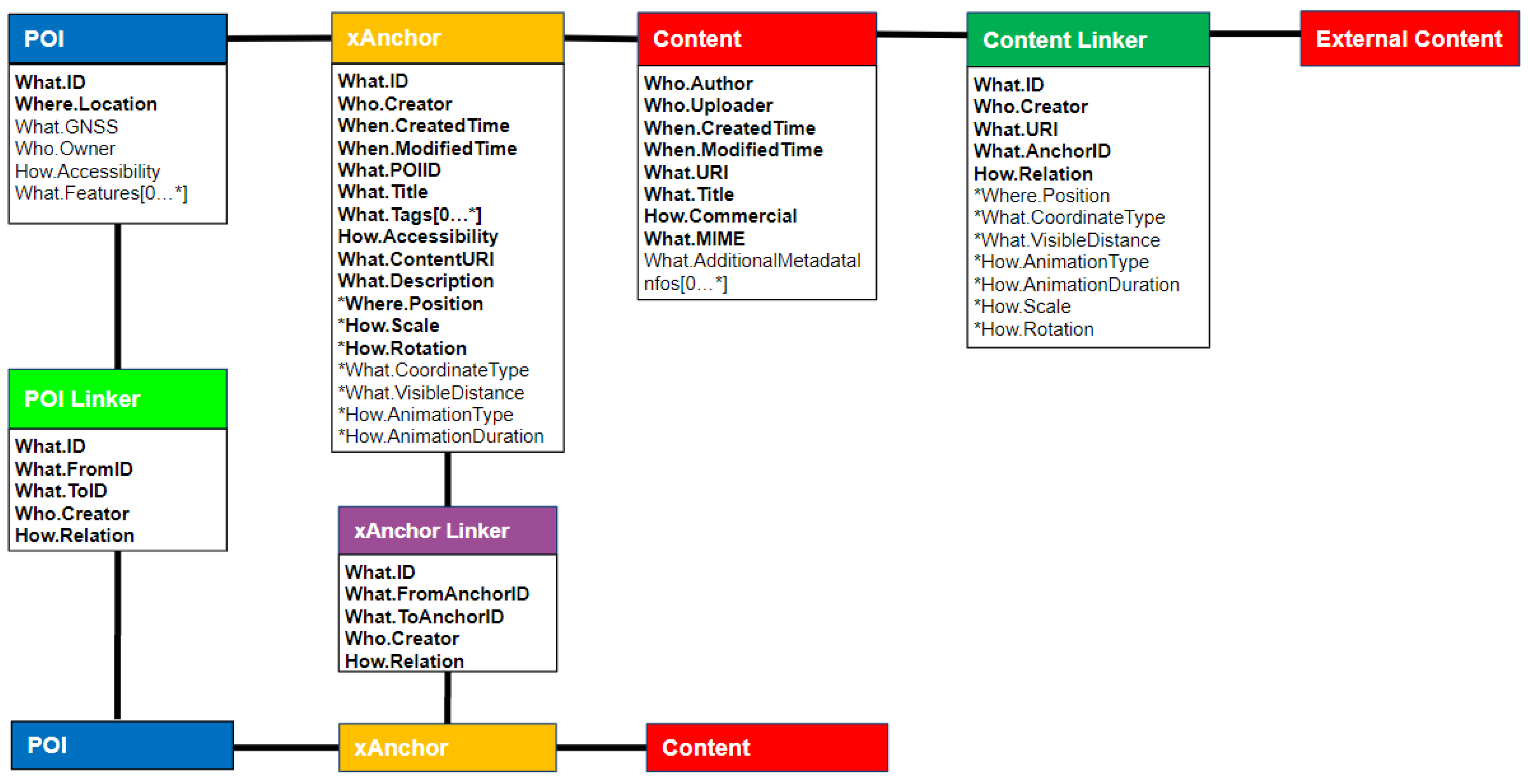
3.1. 5W1H Model-Based Metadata for Context-Aware VR/AR Services
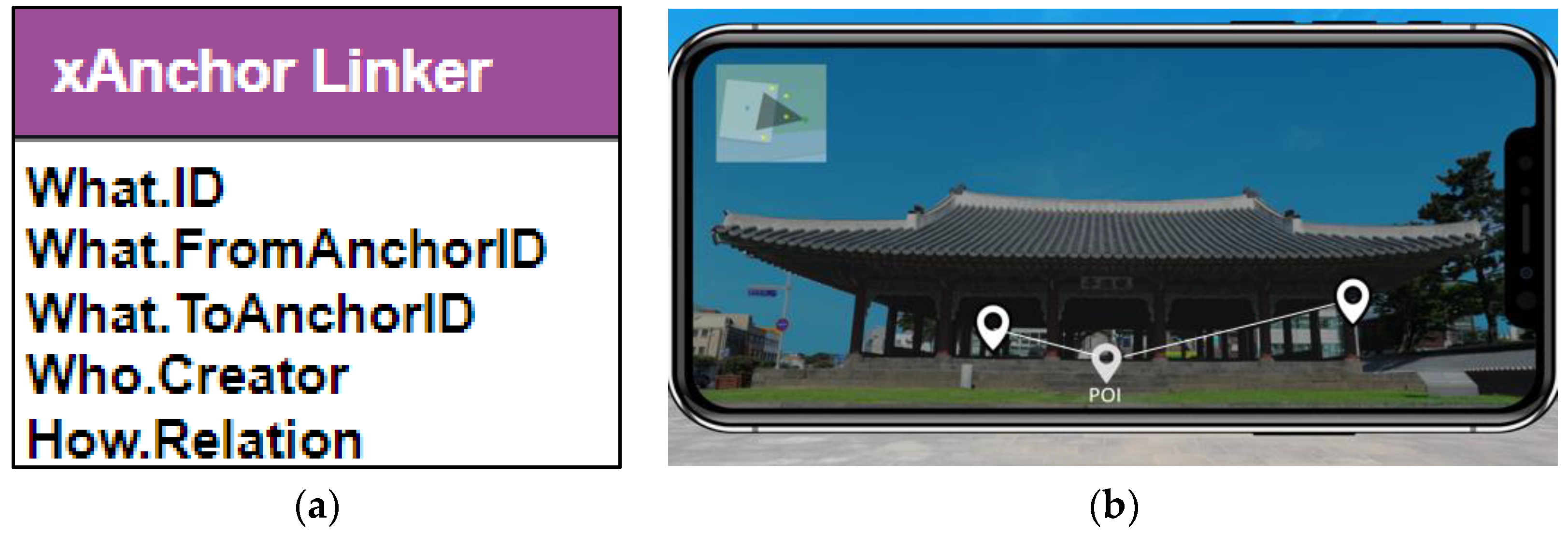
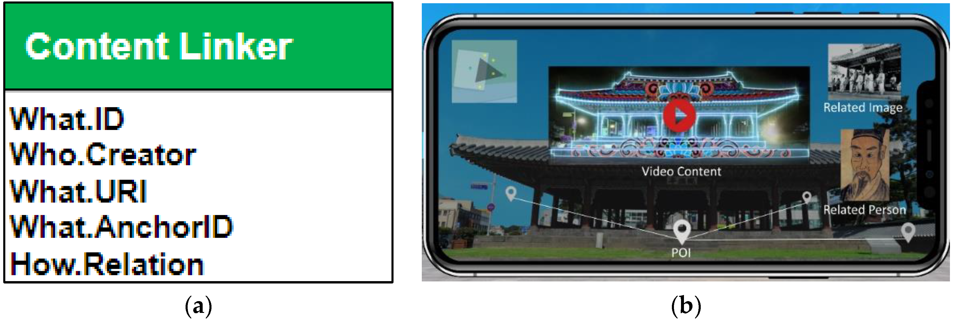
3.2. Linker Metadata for Reflecting Domain Knowledge and Retrieving Related Information
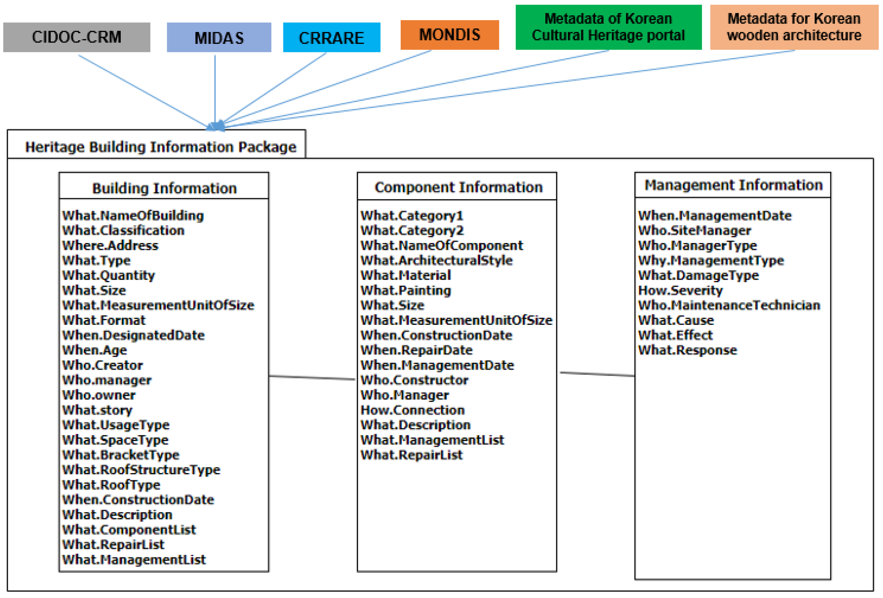
3.3. Heritage Building Information Metadata for Risk Management
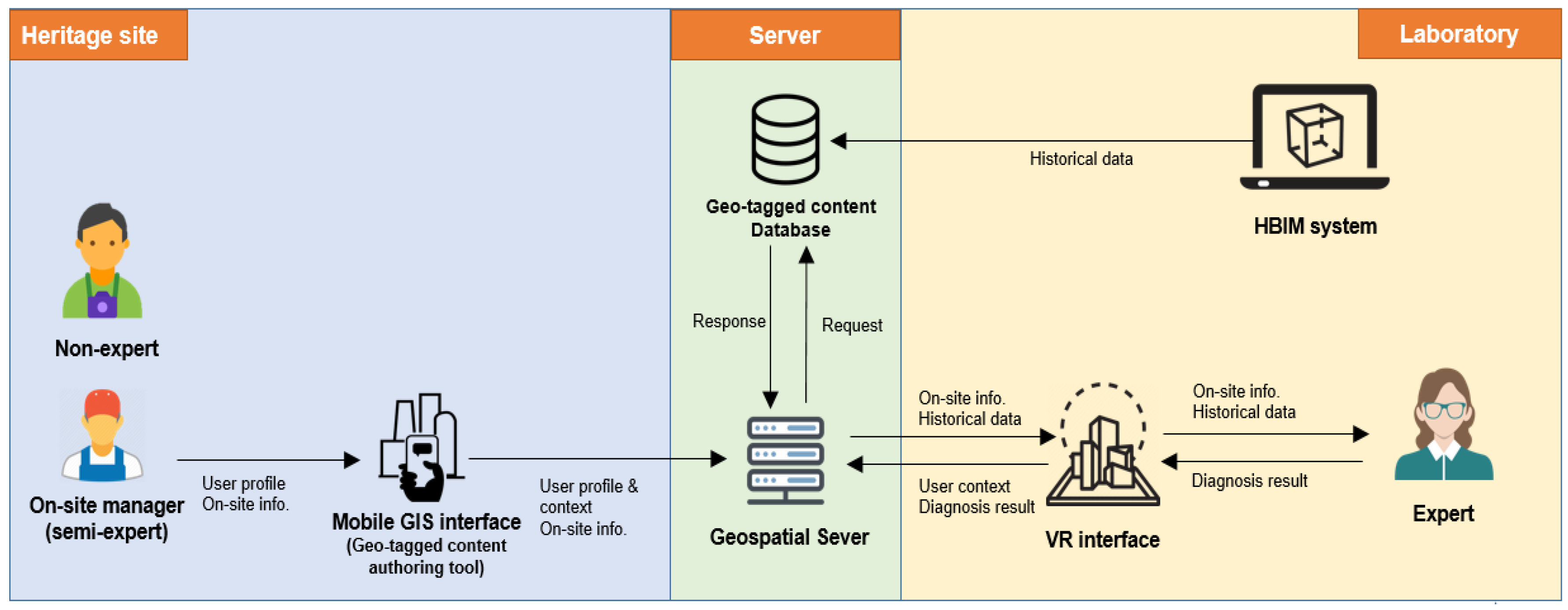
3.4. Framework of Remote Diagnosis in Virtual Reality
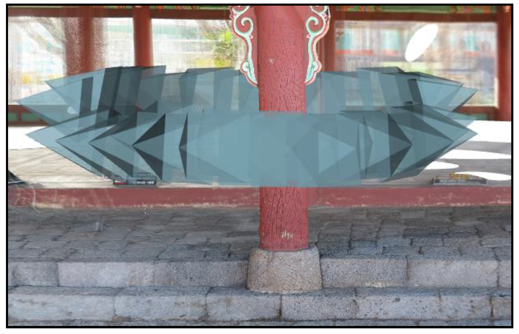
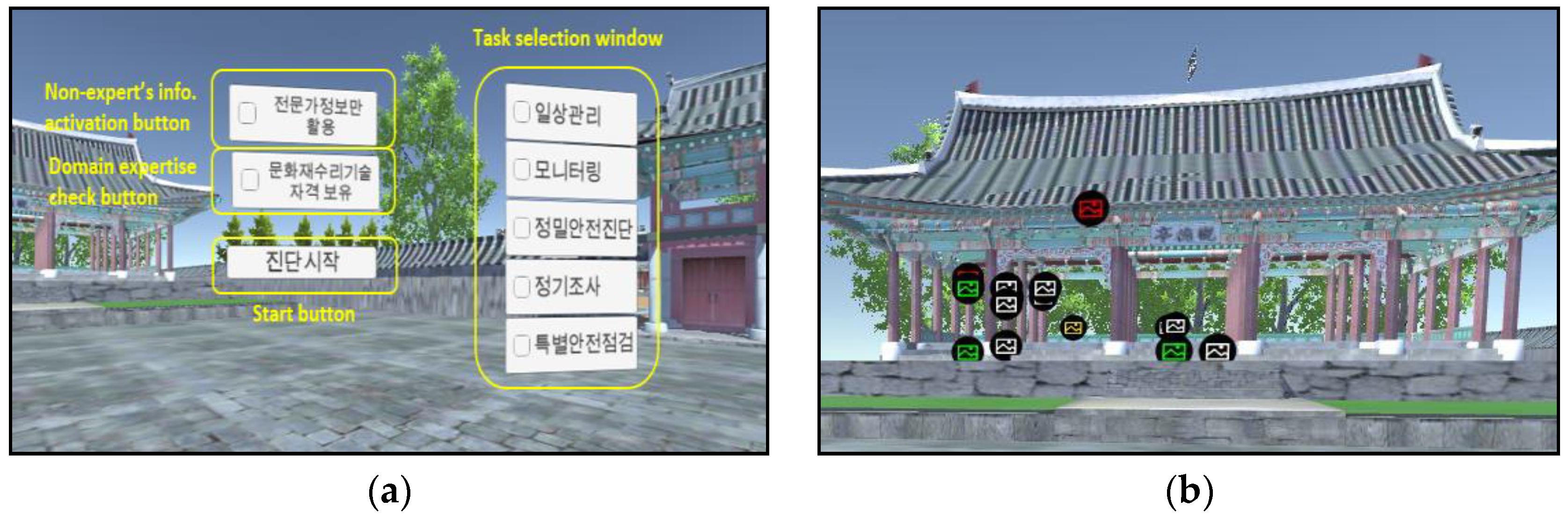
4. Implementation
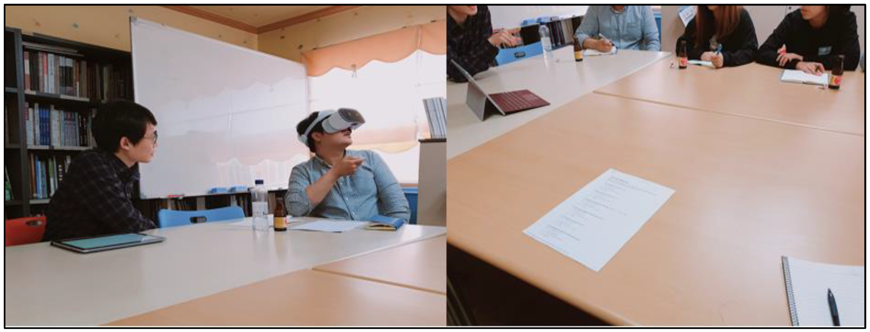
5. Evaluation
5.1. Experiment Design for Remote Diagnosis in Virtual Reality
5.2. Result of Experiment
5.2.1. Focus-Group Interview on Existing Remote Diagnosis
- It is important to update the on-site information frequently.
- Basic information is not necessary because experts have domain expertise.
- It is essential to set priorities of which components should be checked in the application.
- Environmental data (humidity, temperature, etc.) of the heritage site should be recorded and provided.
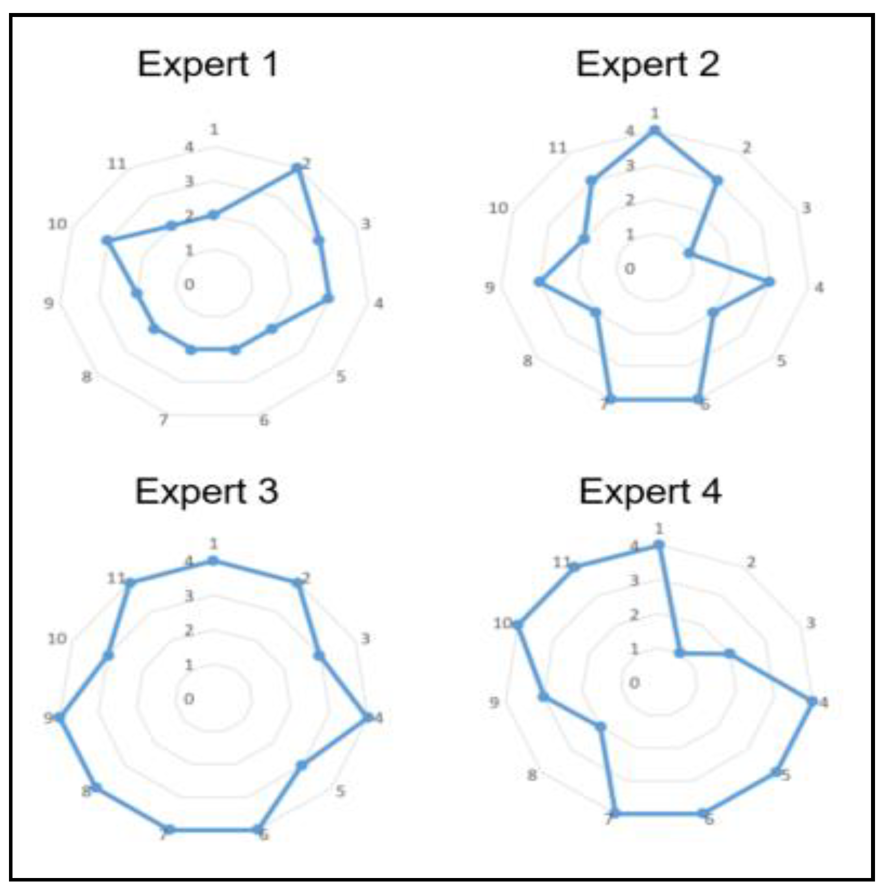
5.2.2. Heuristic Evaluations on Remote Diagnosis in VR
6. Conclusions
Author Contributions
Funding
Acknowledgments
Conflicts of Interest
References
- Styliadis, A.D.; Akbaylar, I.I.; Papadopoulou, D.A.; Hasanagas, N.D.; Roussa, S.A.; Sexidis, L.A. Metadata-based heritage sites modeling with e-learning functionality. J. Cult. Herit. 2009, 10, 296–312. [Google Scholar] [CrossRef] [Green Version]
- Di Mascio, D.; Pauwels, P. Interpreting Metadata and Ontologies of Virtual Heritage Artefacts. Int. J. Herit. Digit. Era 2014, 3, 531–555. [Google Scholar]
- Lechner, M. ARML 2.0 in the context of existing AR data formats. In Proceedings of the 2013 6th Workshop on Software Engineering and Architectures for Realtime Interactive Systems (SEARIS), Orlando, FL, USA, 17 March 2013; pp. 41–47. [Google Scholar]
- Jang, S.; Ko, E.J.; Woo, W. Unified User-Centric Context: Who, Where, When, What, How and Why. 2005. Available online: https://www.researchgate.net/profile/Woontack_Woo/publication/254402919_Unified_User-Centric_Context_Who_Where_When_What_How_and_Why/links/0f3175385def3c6090000000.pdf (accessed on 1 July 2019).
- Oreni, D.; Brumana, R.; Della Torre, S.; Banfi, F. Survey, HBIM and conservation plan of a monumental building damaged by earthquake. Int. Arch. Photogramm. Remote Sens. Spat. Inf. Sci. 2017, 42, 337–342. [Google Scholar] [CrossRef]
- Baik, A.; Alitany, A.; Boehm, J.; Robson, S. Jeddah Historical Building Information Modelling“JHBIM“–Object Library. Int. Soc. Photogramm. Remote Sens. 2014, II–5, 41–47. [Google Scholar] [CrossRef]
- Fassi, F.; Mandelli, A.; Teruggi, S.; Rechichi, F.; Fiorillo, F.; Achille, C. VR for cultural heritage. In Proceedings of the International Conference on Augmented Reality, Virtual Reality and Computer Graphics, Lecce, Italy, 15–18 June 2016; pp. 139–157. [Google Scholar]
- Osello, A.; Lucibello, G.; Morgagni, F. HBIM and Virtual Tools: A New Chance to Preserve Architectural Heritage. Buildings 2018, 8, 12. [Google Scholar] [CrossRef]
- Fregonese, L.; Taffurelli, L.; Adami, A.; Chiarini, S.; Cremonesi, S.; Helder, J.; Spezzoni, A. Survey and modelling for the bim of basilica of san marco in venice. Int. Arch. Photogramm. Remote Sens. Spat. Inf. Sci. 2017, 42, 303–310. [Google Scholar] [CrossRef]
- Lechner, M.; Tripp, M. ARML—An augmented reality standard. Coordinates 2010, 13, 432–440. [Google Scholar]
- Kim, E.; Kim, J.; Woo, W. Metadata schema for context-aware augmented reality applications in cultural heritage domain. 2015 Digit. Herit. 2015, 2, 283–290. [Google Scholar]
- Shin, C.S.; Lee, W.W.; Oh, Y.S.; Suh, Y.J.; Kim, H.J.; Choi, A.Y. CAMAR 2.0: User-driven Context-aware Mobile Augmented Reality. Telecommucation Rev. 2009, 19, 860–876. [Google Scholar]
- Chiabrando, F.; Donato, V.; Turco, M.L.; Santagati, C. Cultural Heritage Documentation, Analysis and Management Using Building Information Modelling: State of the Art and Perspectives. In Mechatronics for Cultural Heritage and Civil Engineering; Springer: Berlin/Heidelberg, Germany, 2018; pp. 181–202. [Google Scholar]
- Lee, J.; Kim, J.; Ahn, J.; Woo, W. Context-aware risk management for architectural heritage using historic building information modeling and virtual reality. J. Cult. Herit. 2019, 38, 242–252. [Google Scholar] [CrossRef]
- Quattrini, R.; Battini, C.; Mammoli, R. Hbim to vr. semantic awareness and data enrichment interoperability for parametric libraries of historical architecture. Int. Arch. Photogramm. Remote Sens. Spat. Inf. Sci. 2018, 42, 937–943. [Google Scholar] [CrossRef]
- Barazzetti, L.; Banfi, F. Historic BIM for Mobile VR/AR Applications. Mix. Real. Gamification Cult. Herit. 2017, 12, 271–290. [Google Scholar]
- Bruno, F.; Bruno, S.; De Sensi, G.; Luchi, M.-L.; Mancuso, S.; Muzzupappa, M. From 3D reconstruction to virtual reality: A complete methodology for digital archaeological exhibition. J. Cult. Herit. 2010, 11, 42–49. [Google Scholar] [CrossRef]
- Chiabrando, F.; Sammartano, G.; Spanò, A. Historical buildings models and their handling via 3D survey: From points clouds to user-oriented hbim. Int. Arch. Photogramm. Remote Sens. Spat. Inf. Sci. 2016, 41, 633–640. [Google Scholar] [CrossRef]
- Azuma, R.T. A survey of augmented reality. Presence Teleoperators Virtual Environ. 1997, 6, 355–385. [Google Scholar] [CrossRef]
- Prieto, J.D.L.F.; Perea, E.C.; Arroyo, F.L. Augmented reality in architecture: Rebuilding archeological heritage. Int. Arch. Photogramm. Remote Sens. Spat. Inf. Sci. 2017, XLII-2/W3, 311–315. [Google Scholar] [CrossRef]
- Chionna, F.; Argese, F.; Palmieri, V.; Spada, I.; Colizzi, L. Integrating building information modeling and augmented reality to improve investigation of historical buildings. Conserv. Sci. Cult. Herit. 2015, 15, 133–163. [Google Scholar]
- Ramos, F.; Trilles, S.; Torres-Sospedra, J.; Perales, F.J. New Trends in Using Augmented Reality Apps for Smart City Contexts. ISPRS Int. J. Geo-Inf. 2018, 7, 478. [Google Scholar] [CrossRef]
- Wallgrün, J.O.; Huang, J.; Zhao, J.; Ebert, C.; Roddy, P.; Awe, J.; Murtha, T.; Klippel, A. Immersive Technologies and Experiences for Archaeological Site Exploration and Analysis. In International Conference on Spatial Information Theory; Springer: Berlin/Heidelberg, Germany, 2017; pp. 307–314. [Google Scholar]
- Fonnet, A.; Alves, N.; Sousa, N.; Guevara, M.; Magalhaes, L. Heritage BIM integration with mixed reality for building preventive maintenance. In Proceedings of the 2017 24º Encontro Portugues de Computacao Grafica e Interacao (EPCGI), Guimaraes, Portugal, 12–13 October 2017; pp. 1–7. [Google Scholar]
- Zabed Ahmed, S.M. A comparison of usability techniques for evaluating information retrieval system interfaces. Perform. Meas. Metr. 2008, 9, 48–58. [Google Scholar] [CrossRef]
- Microsoft Azure. Available online: https://azure.microsoft.com/ko-kr/services/spatial-anchors/ (accessed on 10 July 2019).
- GoogleARCore. Available online: https://developers.google.com/ar/reference/java/arcore/reference/com/google/ar/core/Anchor (accessed on 10 July 2019).
- Kelly, D. Methods for evaluating interactive information retrieval systems with users. Found. Trends Inf. Retr. 2009, 3, 1–224. [Google Scholar] [CrossRef]


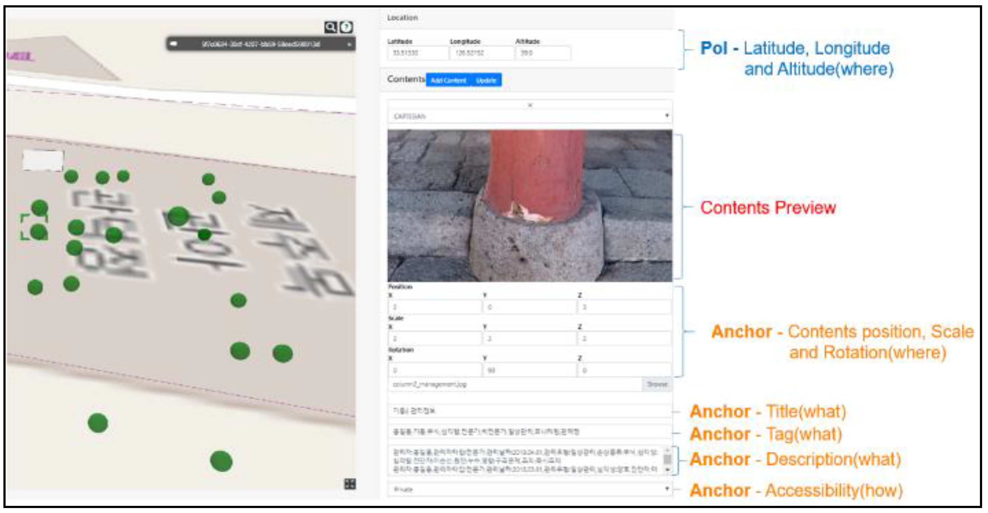
| Category | 5W1H | Metadata Name | Example |
|---|---|---|---|
| POI | What | ID | 22 |
| Where | Location | “latitude”: 33.51330, “longitude”:126.52152, “altitude”: 39.0 | |
| xAnchor | What | ID | 147 |
| Who | Creator | Jack | |
| When | Created Time | 1 April 2019 | |
| When | Modified Time | 2 April 2019 | |
| What | POI ID | 22 | |
| Where | Content Location | “positionx”: 1, “positiony”: 1, “positionz”: 1 “scalex”: 1, “scaley”: 1, “scalez”: 1 “locationx”: 1, “locationy”: 1, “locationz”: 1 | |
| What | Title | Column2 management information | |
| What | Tag | 1 April 2019, Column (what), Serious (how), Corrosion (what), Monitoring (why) | |
| What | Description | Maintenance technician: Brian, Response: Repair & maintenance | |
| What | Accessibility | Public | |
| What | Content URI | https://s3.ap-northeast-2.amazoneaws.com/kctm/server3/1/column.jpg | |
| Content | Who | Author | John |
| Who | Uploader | John | |
| When | Created Time | 2 April 2019 | |
| When | Modified Time | 2 April 2019 | |
| What | URL | https://s3.ap-northeast-2.amazoneaws.com/kctm/server3/1/column.jpg | |
| What | Title | Column photo | |
| How | Commercial | Noncommercial | |
| What | Internet media types (MIME types) | image/jpeg |
| No. | Criteria | Description | |
|---|---|---|---|
| 1 | Context | Provision of information according to purpose and task Provision of information according to behavior | |
| 2 | Performance | Operational error System error | |
| 3 | Interaction | The method and process to confirm information for the task | |
| 4 | Usability | Ease of learning | The degree to understand task |
| 5 | Ease of use | The degree to distinguish or identify information | |
| 6 | Effectiveness | Accuracy and completeness with which users achieve specified goals | |
| 7 | Efficiency | Resources expended in relation to the accuracy and completeness with which users achieve goals | |
| 8 | Flow | Mental state of operation in which a person is fully immersed in what he she is doing, characterized by a feeling of energized focus, full involvement, and success in the process of the activity | |
| 9 | Engagement | A quality of user experiences with technology that is characterized by challenge, aesthetic and sensory appeal, feedback, novelty, interactivity, perceived control and time, awareness, motivation, and interest and affect | |
| 10 | Satisfaction | Freedom from discomfort and positive attitudes of the user to the product | |
| 11 | Preference | Evaluation of providing information and interfaces based on preference | |
| Expert No. | Age/Sex | Career (Year) | Advantage | Disadvantage | Suggestion |
|---|---|---|---|---|---|
| 1 | 20–30/Female | 3 | Showing the priority of diagnosis | Difficulty of navigation and checking images | A more intuitive interface for navigation and confirmation of images |
| 2 | 30–40/Female | Over 10 | Providing external information | Difficulty of navigation and checking images | A record method for the positional movement of components |
| 3 | 30–40/Male | Over 10 | Supporting to understand the situation faster | Difficulty of navigation and checking images | A hybrid method with existing diagnosis methods (photos, drawings, and reports) |
| 4 | 30–40/Female | Over 10 | Viewing information from a variety of sources and formats | Dizziness | A function to check photos in chronological order. |
© 2019 by the authors. Licensee MDPI, Basel, Switzerland. This article is an open access article distributed under the terms and conditions of the Creative Commons Attribution (CC BY) license (http://creativecommons.org/licenses/by/4.0/).
Share and Cite
Lee, J.; Kim, J.; Ahn, J.; Woo, W. Remote Diagnosis of Architectural Heritage Based on 5W1H Model-Based Metadata in Virtual Reality. ISPRS Int. J. Geo-Inf. 2019, 8, 339. https://0-doi-org.brum.beds.ac.uk/10.3390/ijgi8080339
Lee J, Kim J, Ahn J, Woo W. Remote Diagnosis of Architectural Heritage Based on 5W1H Model-Based Metadata in Virtual Reality. ISPRS International Journal of Geo-Information. 2019; 8(8):339. https://0-doi-org.brum.beds.ac.uk/10.3390/ijgi8080339
Chicago/Turabian StyleLee, Jongwook, Junki Kim, Jaehong Ahn, and Woontack Woo. 2019. "Remote Diagnosis of Architectural Heritage Based on 5W1H Model-Based Metadata in Virtual Reality" ISPRS International Journal of Geo-Information 8, no. 8: 339. https://0-doi-org.brum.beds.ac.uk/10.3390/ijgi8080339