Spatial Knowledge Acquisition with Mobile Maps: Effects of Map Size on Users’ Wayfinding Performance with Interactive Interfaces


Abstract
:1. Introduction
2. Related Works
2.1. Interactive Interface and Mobile Map Size
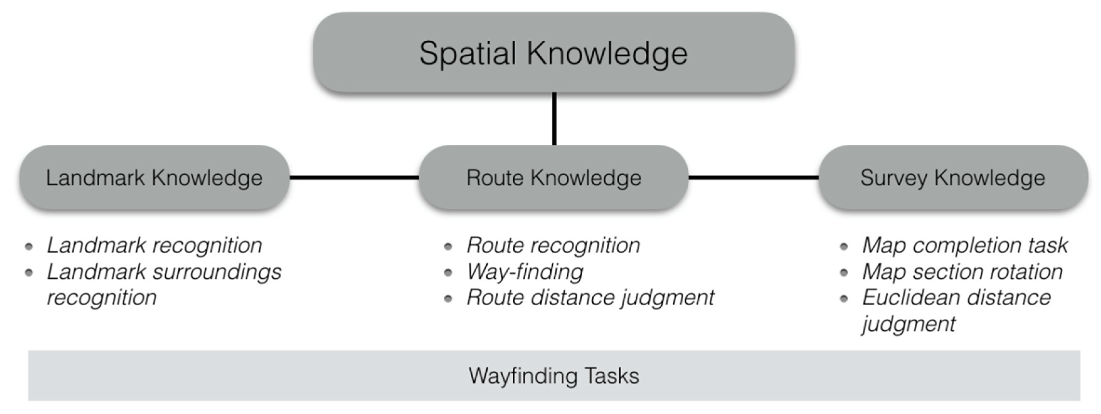
2.2. Spatial Knowledge Acquired From Mobile Maps
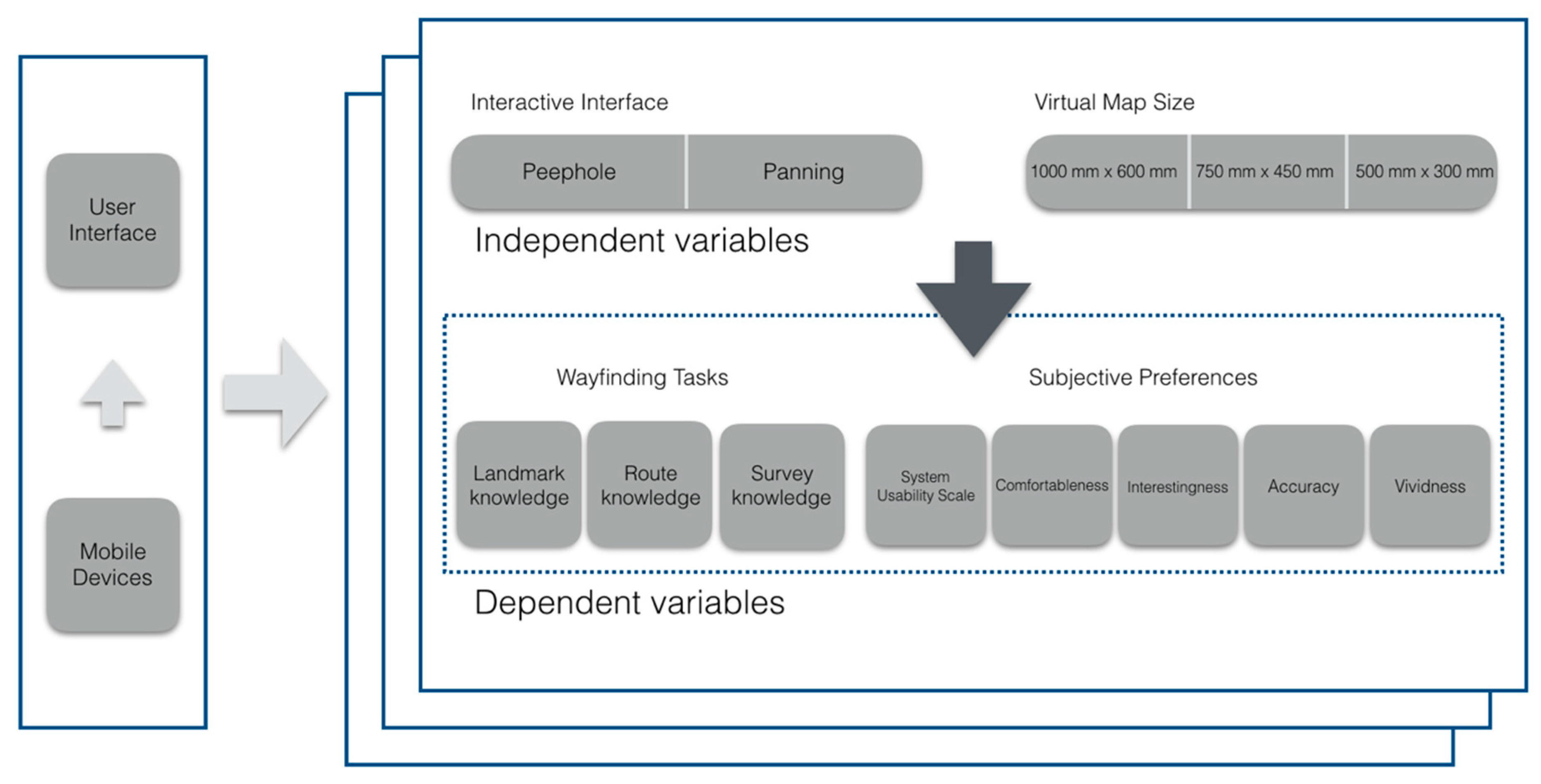
3. Research Objectives
- Which one of the interactive interfaces obtains better wayfinding performance?
- Does the large map size consume more time when using the mobile device?
- What is the interaction effect between map size and interactive interface?
- Can the peephole and panning interfaces contribute to usability?
- During wayfinding, can different interactive interfaces affect participants’ evaluation of their preferences using a mobile device?
4. Method
4.1. Participants
4.2. Materials and Apparatus
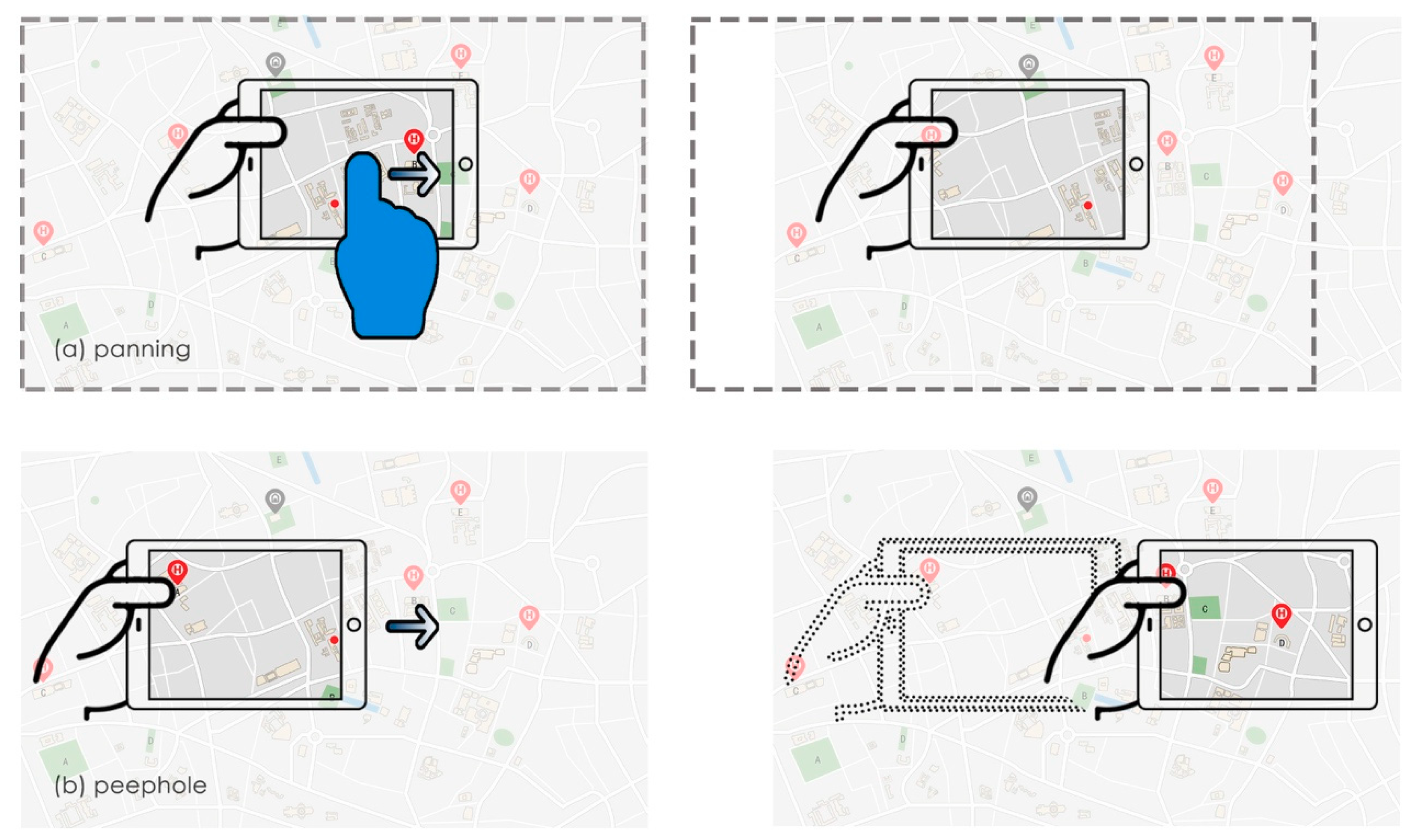
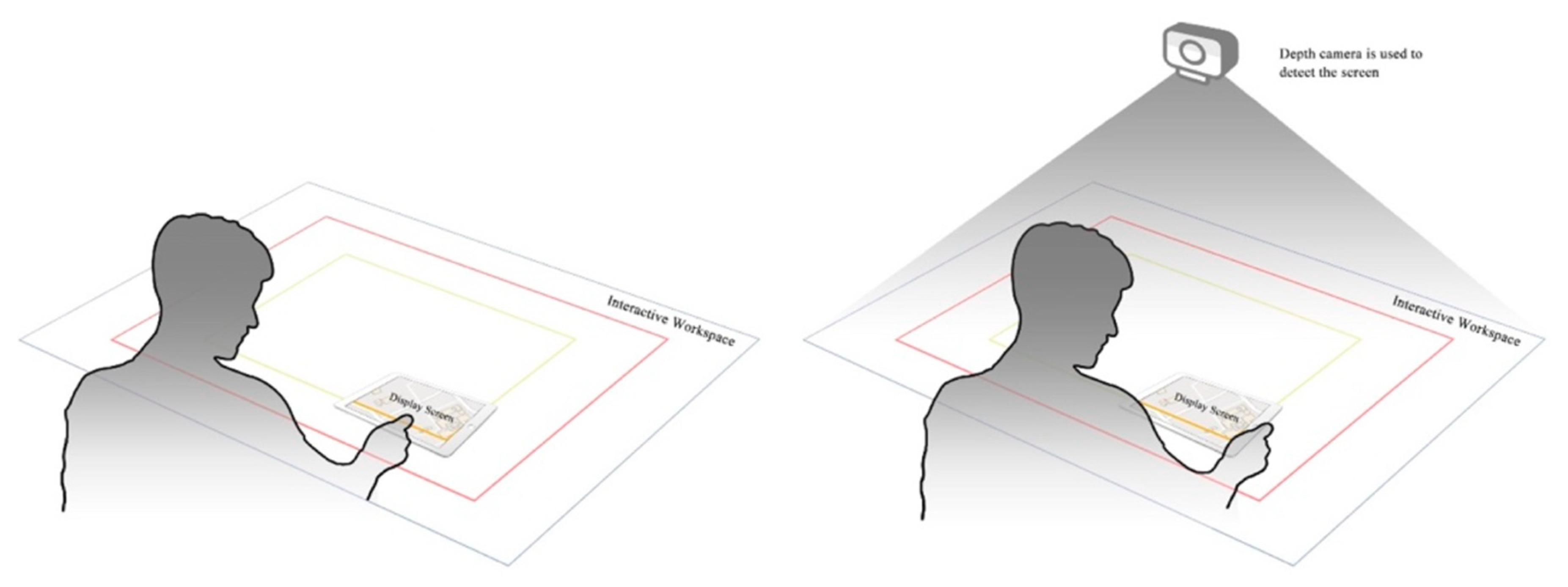
4.3. Map Size and Interactive Interface
4.4. Task Type
4.5. Procedure
5. Experimental Results
5.1. Analysis of Task Performance Time
5.2. Analysis of the System Usability Scale Questionnaire
5.3. Summary of Task Performance Time and the SUS Questionnaire Results
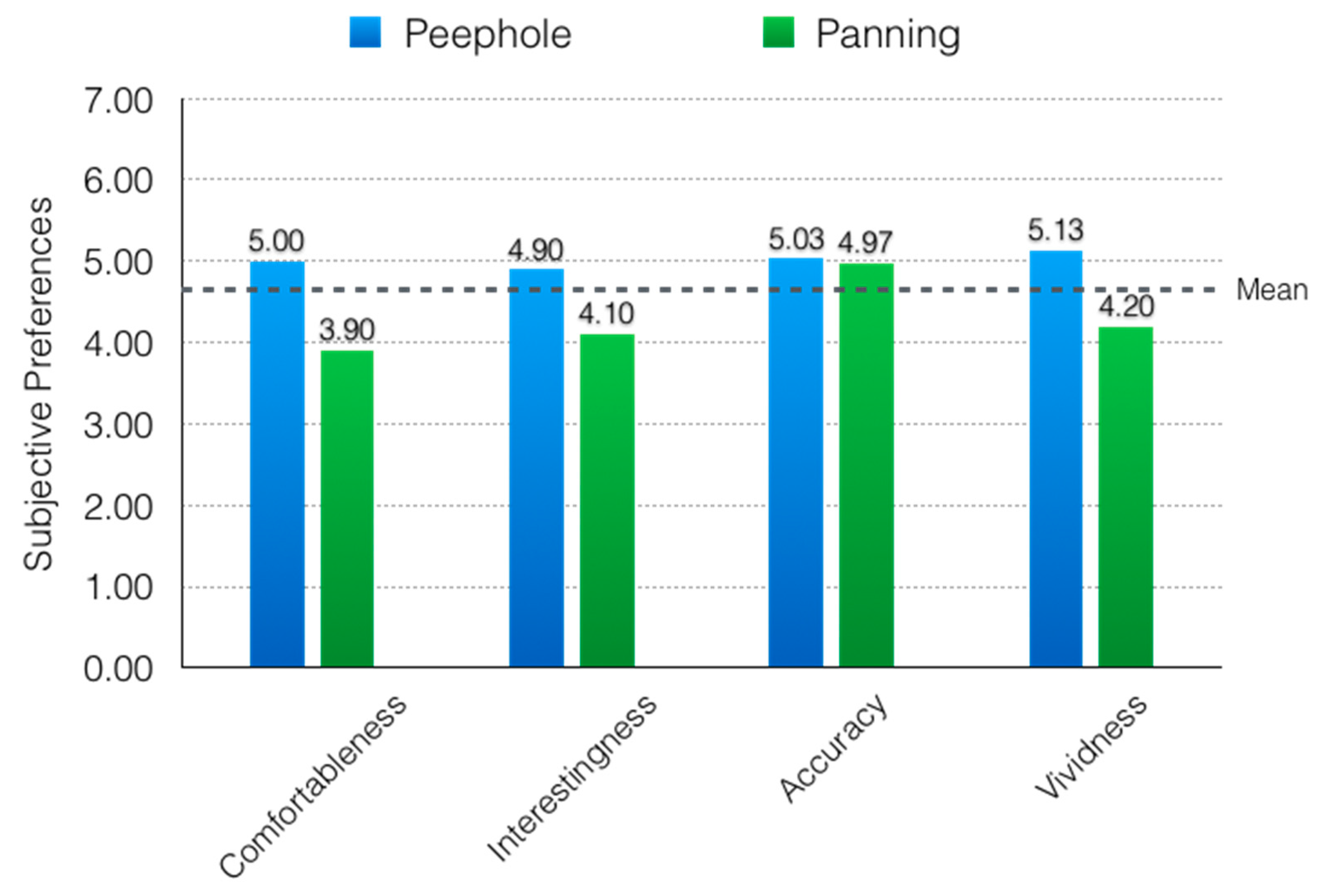
5.4. Analysis of Subjective Preference
6. Discussion
7. Conclusions
- Participants interacting with the peephole interface can gain better wayfinding performance than with a panning interface when performing the Euclidean distance judgment and the route recognition tasks.
- In completing different types of tasks, the participants exhibit different wayfinding performances. When participants are dealing with the survey knowledge map section rotation task, the appropriateness of the interactive interface is the panning for a map larger than 750 mm × 450 mm. Using a peephole interface to obtain wayfinding information is a better choice when dealing with maps smaller than 750 mm × 450 mm.
- According to the analysis of SUS, the peephole interface can contribute to increased usability, and it provided better interface usability than the panning interface when participants were wayfinding with their mobile devices.
- There was a positive impact on the participants’ preferences in the peephole interface. Using the peephole interface may result in the participants experiencing more comfortableness and vividness.
Author Contributions
Funding
Acknowledgments
Conflicts of Interest
References
- Burigat, S.; Chittaro, L. Visualizing references to off-screen content on mobile devices: A comparison of Arrows, Wedge, and Overview+ Detail. Interact. Comput. 2011, 23, 156–166. [Google Scholar] [CrossRef]
- Burigat, S.; Chittaro, L.; Gabrielli, S. Visualizing locations of off-screen objects on mobile devices: A comparative evaluation of three approaches. In Proceedings of the 8th Conference on Human-Computer Interaction with Mobile Devices and Services, Helsinki, Finland, 12–15 September 2006; pp. 239–246. [Google Scholar]
- Rohs, M.; Schleicher, R.; Schoning, J.; Essl, G.; Naumann, A.; Kruger, A. Impact of item density on the utility of visual context in magic lens interactions. Pers. Ubiquitous Comput. 2009, 13, 633–646. [Google Scholar] [CrossRef]
- Ahmadpoor, N.; Smith, A.D. Spatial knowledge acquisition and mobile maps: The role of environmental legibility. Cities 2020, 101, 102700. [Google Scholar] [CrossRef]
- Ishikawa, T.; Fujiwara, H.; Imai, O.; Okabe, A. Wayfinding with a GPS-based mobile navigation system: A comparison with maps and direct experience. J. Environ. Psychol. 2008, 28, 74–82. [Google Scholar] [CrossRef]
- Willis, K.S.; Hölscher, C.; Wilbertz, G.; Li, C. A comparison of spatial knowledge acquisition with maps and mobile maps. Comput. Environ. Urban Syst. 2009, 33, 100–110. [Google Scholar] [CrossRef]
- Li, X.; Chen, C.-H. The effect of peephole interaction mode and user experience on wayfinding performance. In Advances in Usability, User Experience, Wearable and Assistive Technology, Proceedings of the AHFE 2020: Virtual Conferences on Usability and User Experience, Human Factors and Assistive Technology, Human Factors and Wearable Technologies, and Virtual Environments and Game Design, San Diego, CA, USA, 16–20 July 2020; Springer: Berlin/Heidelberg, Germany, 2020; pp. 29–36. [Google Scholar]
- Kaufmann, B.; Ahlström, D. Studying spatial memory and map navigation performance on projector phones with peephole interaction. In Proceedings of the SIGCHI Conference on Human Factors in Computing Systems, Paris, France, 27 April–2 May 2013; pp. 3173–3176. [Google Scholar]
- Grubert, J.; Pahud, M.; Grasset, R.; Schmalstieg, D.; Seichter, H. The utility of Magic Lens interfaces on handheld devices for touristic map navigation. Pervasive Mob. Comput. 2015, 18, 88–103. [Google Scholar] [CrossRef]
- Goldiez, B.F.; Ahmad, A.M.; Hancock, P.A. Effects of augmented reality display settings on human wayfinding performance. IEEE Trans. Syst. Man Cybern. Part C Appl. Rev. 2007, 37, 839–845. [Google Scholar] [CrossRef] [Green Version]
- Chen, C.H.; Chen, S.C. Effects of 2D wedge design as a wayfinding facilitator in a 3D virtual environment. J. Soc. Inf. Disp. 2015, 23, 27–35. [Google Scholar] [CrossRef]
- Zheng, M.-C.; Chen, C.-I. Designing indoor navigation interfaces on smartphones compatible with human information processing in an emergency evacuation scenario. J. Asian Archit. Build. Eng. 2019, 18, 599–616. [Google Scholar] [CrossRef]
- Araki, T.; Komuro, T. On-mouse projector: Peephole interaction using a mouse with a mobile projector. Pervasive Mob. Comput. 2018, 50, 124–136. [Google Scholar] [CrossRef]
- Wu, F.-G.; Lin, H.; You, M. The enhanced navigator for the touch screen: A comparative study on navigational techniques of web maps. Displays 2011, 32, 284–295. [Google Scholar] [CrossRef]
- Fitzmaurice, G.W. Situated information spaces and spatially aware palmtop computers. Commun. ACM 1993, 36, 39–49. [Google Scholar] [CrossRef]
- Yee, K.-P. Peephole displays: Pen interaction on spatially aware handheld computers. In Proceedings of the SIGCHI Conference on Human Factors in Computing Systems, Ft. Lauderdale, FL, USA, 5–10 April 2003; pp. 1–8. [Google Scholar]
- Mehra, S.; Werkhoven, P.; Worring, M. Navigating on handheld displays: Dynamic versus static peephole navigation. ACM Trans. Comput. Hum. Interact. Tochi 2006, 13, 448–457. [Google Scholar] [CrossRef] [Green Version]
- Rohs, M.; Schöning, J.; Raubal, M.; Essl, G.; Krüger, A. Map navigation with mobile devices: Virtual versus physical movement with and without visual context. In Proceedings of the 9th International Conference on Multimodal Interfaces, Nagoya, Aichi, Japan, 12–15 November 2007; pp. 146–153. [Google Scholar]
- Guiard, Y.; Beaudouin-Lafon, M.; Bastin, J.; Pasveer, D.; Zhai, S. View size and pointing difficulty in multi-scale navigation. In Proceedings of the Working Conference on Advanced Visual Interfaces, Gallipoli, Italy, 25–28 May 2004; pp. 117–124. [Google Scholar]
- Jones, M.; Marsden, G.; Mohd-Nasir, N.; Boone, K.; Buchanan, G. Improving web interaction on small displays. Comput. Netw. Int. J. Comput. Telecommun. Netw. 1999, 31, 1129–1137. [Google Scholar] [CrossRef]
- Büring, T.; Gerken, J.; Reiterer, H. Zoom interaction design for pen-operated portable devices. Int. J. Hum. Comput. Stud. 2008, 66, 605–627. [Google Scholar] [CrossRef] [Green Version]
- Baudisch, P.; Rosenholtz, R. Halo: A technique for visualizing off-screen objects. In Proceedings of the SIGCHI Conference on Human Factors in Computing Systems, Ft. Lauderdale, FL, USA, 5–10 April 2003; pp. 481–488. [Google Scholar]
- Brooke, J. SUS: A “quick and dirty’usability. Usability Eval. Ind. 1996, 189. [Google Scholar] [CrossRef]
- Nielsen, J. Usability Engineering; Morgan Kaufmann: Burlington, MA, USA, 1994. [Google Scholar]
- Morrison, A.; Oulasvirta, A.; Peltonen, P.; Lemmela, S.; Jacucci, G.; Reitmayr, G.; Näsänen, J.; Juustila, A. Like bees around the hive. In Proceedings of the 27th International Conference on Human factors in Computing Systems—CHI 09, Boston, MA, USA, 4–9 April 2009; pp. 1889–1898. [Google Scholar]
- Golledge, R.G. Human wayfinding and cognitive maps. In Wayfinding Behavior: Cognitive Mapping and Other Spatial Processes; The John Hopkins University Press: Baltimore, MD, USA, 1999; pp. 5–45. [Google Scholar]
- Montello, D.R. Navigation. In The Cambridge Handbook of Visuospatial Thinking; Miyake, A., Shah, P., Eds.; Cambridge University Press: Cambridge, UK, 2005; pp. 257–294. [Google Scholar]
- Huang, H.; Schmidt, M.; Gartner, G. Spatial knowledge acquisition in the context of GPS-based pedestrian navigation. In Maps for the Future: Children, Education and Internet; Zentai, L., Reyes Nunez, J., Eds.; Springer: Berlin/Heidelberg, Germany, 2012; pp. 127–137. [Google Scholar] [CrossRef]
- Wiener, J.M.; Büchner, S.J.; Hölscher, C. Taxonomy of human wayfinding tasks: A knowledge-based approach. Spat. Cogn. Comput. 2009, 9, 152–165. [Google Scholar] [CrossRef]
- König, S.U.; Clay, V.; Nolte, D.; Duesberg, L.; Kuske, N.; König, P. Learning of spatial properties of a large-scale virtual city with an Interactive map. Front. Hum. Neurosci. 2019, 13. [Google Scholar] [CrossRef] [Green Version]
- Löwen, H.; Krukar, J.; Schwering, A. Spatial learning with orientation maps: The influence of different environmental features on spatial knowledge acquisition. ISPRS Int. J. Geo. Inf. 2019, 8, 149. [Google Scholar] [CrossRef] [Green Version]
- Coluccia, E.; Iosue, G.; Brandimonte, M.A. The relationship between map drawing and spatial orientation abilities: A study of gender differences. J. Environ. Psychol. 2007, 27, 135–144. [Google Scholar] [CrossRef]
- Siegel, A.W.; White, S.H. The development of spatial representations of large-scale environments. In Advances in Child Development and Behavior; Reese, H.W., Ed.; JAI: Atlanta, GA, USA, 1975; Volume 10, pp. 9–55. [Google Scholar]
- Bosco, A.; Coluccia, E. Assessing age differences in spatial orientation tasks following map study. Imagin. Cogn. Personal. 2003, 23, 233–240. [Google Scholar] [CrossRef]
- Bosco, A.; Longoni, A.M.; Vecchi, T. Gender effects in spatial orientation: Cognitive profiles and mental strategies. Appl. Cogn. Psychol. 2004, 18, 519–532. [Google Scholar] [CrossRef] [PubMed] [Green Version]
- Montello, D.R. A new framework for understanding the acquisition of spatial knowledge in large-scale environments. Spat. Temporal Reason. Geogr. Inf. Syst. 1998, 143–154. [Google Scholar]
- Rädle, R.; Jetter, H.-C.; Marquardt, N.; Reiterer, H.; Rogers, Y. HuddleLamp: Spatially-aware mobile displays for ad-hoc around-the-table collaboration. In Proceedings of the Ninth ACM International Conference on Interactive Tabletops and Surfaces, Dresden, Germany, 16–19 November 2014; pp. 45–54. [Google Scholar]
- Hürst, W.; Bilyalov, T. Dynamic versus static peephole navigation of VR panoramas on handheld devices. In Proceedings of the 9th International Conference on Mobile and Ubiquitous Multimedia, Limassol, Cyprus, 1–3 December 2010; pp. 1–8. [Google Scholar]
- Li, R.; Zhao, J. Off-screen landmarks on mobile devices: Levels of measurement and the perception of distance on resized icons. Ki Künstliche Intell. 2017, 31, 141–149. [Google Scholar] [CrossRef]
- Burigat, S.; Chittaro, L.; Gabrielli, S. Navigation techniques for small-screen devices: An evaluation on maps and web pages. Int. J. Hum. Comput. Stud. 2008, 66, 78–97. [Google Scholar] [CrossRef]
- Simmons, A. Spatial perception from a Cartesian point of view. Philos. Top. 2003, 31, 395–423. [Google Scholar] [CrossRef]
- Montello, D.R.; Richardson, A.E.; Hegarty, M.; Provenza, M. A comparison of methods for estimating directions in egocentric space. Perception 1999, 28, 981–1000. [Google Scholar] [CrossRef] [Green Version]
- Münzer, S.; Zimmer, H.D.; Baus, J. Navigation assistance: A trade-off between wayfinding support and configural learning support. J. Exp. Psychol. Appl. 2012, 18, 18–37. [Google Scholar] [CrossRef]
- Pahud, M.; Hinckley, K.; Iqbal, S.; Sellen, A.; Buxton, B. Toward compound navigation tasks on mobiles via spatial manipulation. In Proceedings of the 15th International Conference on Human-Computer Interaction with Mobile Devices and Services, Munich, Germany, 27–30 August 2013; pp. 113–122. [Google Scholar]
- Grubert, J.; Langlotz, T.; Grasset, R. Augmented reality browser survey. In Technical Report; Institute for Computer Graphics and Vision, Graz University of Technology: Graz, Austria, 2011. [Google Scholar]


| Task Types | Descriptions |
|---|---|
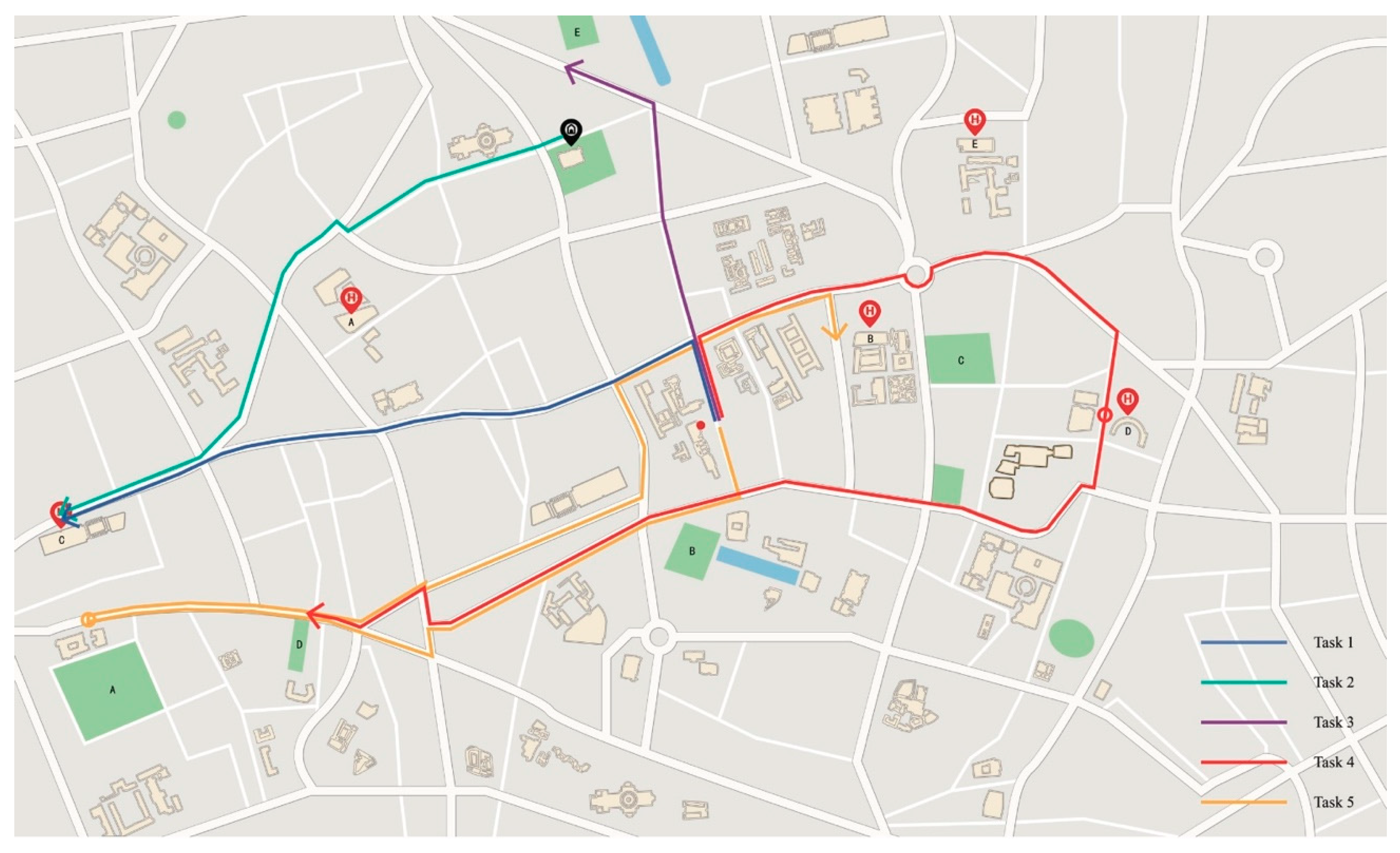
| Task 1: Survey knowledge- Euclidean distance judgment | Please find the hospital farthest from your starting point |
| Task 2: Route knowledge-route distance judgment | Please plan the route from home to the hospital named C, and then plan the shortest route between the two targets provided |
| Task 3: Landmark knowledge-landmark recognition | Please find the park named E |
| Task 4: Survey knowledge-map section rotation | Please find a building and a location with the same name. One is located east of your starting point and the other is located southwest of your starting point |
| Task 5: Route knowledge-route recognition | Please find the park farthest from your starting point, then find the nearest hospital and find the route between these two targets |
| Source | SS | df | MS | F | P | η2 | Post Hoc (LSD) |
|---|---|---|---|---|---|---|---|
| Interactive interface | 3941.627 | 1 | 3941.627 | 9.472 | 0.003 ** | 0.149 | Peephole < Panning |
| Map size | 2886.703 | 2 | 1443.352 | 3.468 | 0.038 * | 0.114 | Small < Large; Medium < Large |
| Interactive interface * Map size | 616.818 | 2 | 308.409 | 0.741 | 0.481 | 0.027 |
| Source | SS | df | MS | F | P | η2 | Post Hoc (LSD) |
|---|---|---|---|---|---|---|---|
| Interactive interface | 126.470 | 1 | 126.470 | 1.954 | 0.168 | 0.035 | |
| Map size | 1144.459 | 2 | 572.230 | 8.843 | 0.000 ** | 0.247 | Small < Large; Medium < Large |
| Interactive interface * Map size | 141.071 | 2 | 70.535 | 1.090 | 0.343 | 0.039 |
| Source | SS | df | MS | F | P | η2 | Post Hoc (LSD) |
|---|---|---|---|---|---|---|---|
| Interactive interface | 1290.912 | 1 | 1290.912 | 1.148 | 0.289 | 0.021 | |
| Map size | 9247.512 | 2 | 4623.756 | 4.112 | 0.022 * | 0.132 | Small < Large |
| Interactive interface * Map size | 7604.232 | 2 | 3802.116 | 3.381 | 0.041 * | 0.111 |
| Source | SS | df | MS | F | P | η2 | Post Hoc (LSD) |
|---|---|---|---|---|---|---|---|
| Interactive interface | 1279.702 | 1 | 1279.702 | 4.561 | 0.037 * | 0.078 | Peephole < Panning |
| Map size | 1300.511 | 2 | 650.255 | 2.318 | 0.108 | 0.079 | |
| Interactive interface * Map size | 1244.036 | 2 | 622.018 | 2.217 | 0.119 | 0.076 |
| Source | SS | df | MS | F | P | η2 | Post Hoc (LSD) |
|---|---|---|---|---|---|---|---|
| Interactive interface | 1108.504 | 1 | 1108.504 | 4.152 | 0.047 * | 0.071 | Peephole < Panning |
| Map size | 769.785 | 2 | 384.893 | 1.441 | 0.246 | 0.051 | |
| Interactive interface * Map size | 80.242 | 2 | 40.121 | 0.150 | 0.861 | 0.006 |
| Task/SUS | Main Effect | Interaction Effect | |
|---|---|---|---|
| Interactive Interface | Map Size | ||
| Task 1 | Peephole < Panning | Small < Large; Medium < Large | |
| Task 2 | |||
| Task 3 | Small < Large; Medium < Large | ||
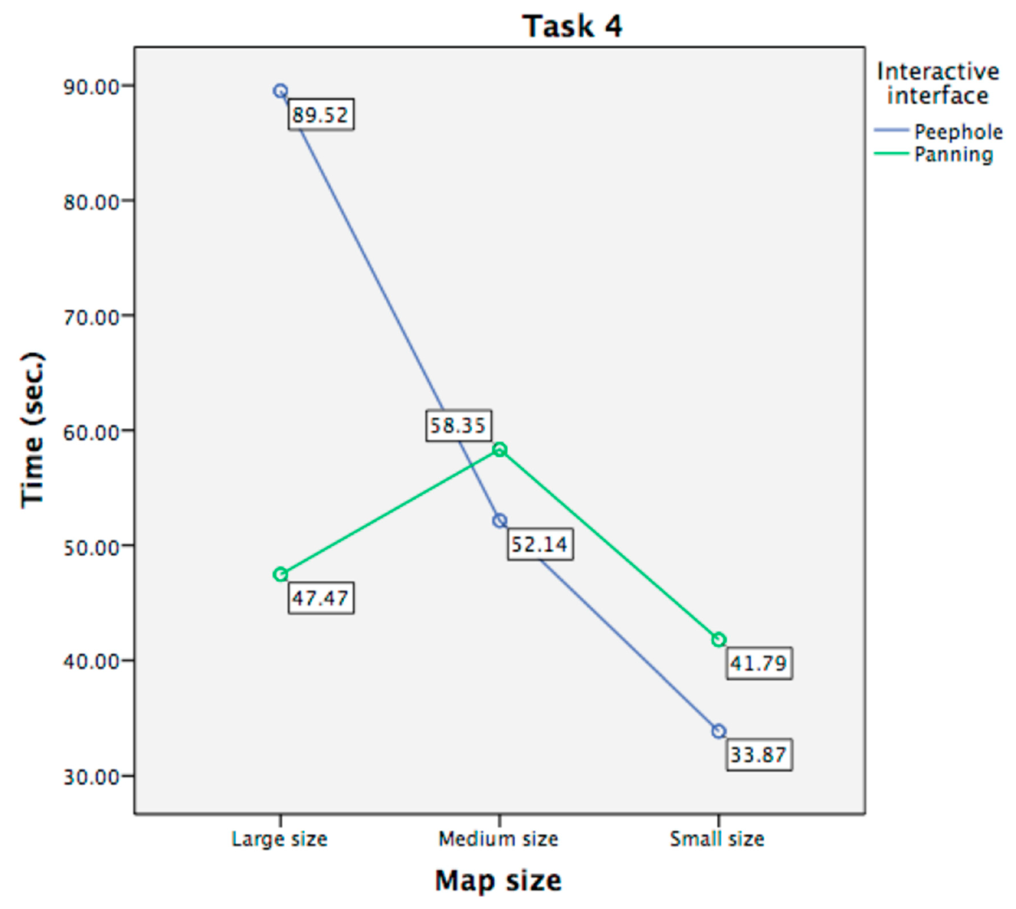
| Task 4 | Small < Large | Large Size: Panning < Peephole; Medium Size: Peephole < Panning; Small Size: Peephole < Panning | |
| Task 5 | Peephole < Panning | ||
| SUS | Peephole < Panning | ||
Publisher’s Note: MDPI stays neutral with regard to jurisdictional claims in published maps and institutional affiliations. |
© 2020 by the authors. Licensee MDPI, Basel, Switzerland. This article is an open access article distributed under the terms and conditions of the Creative Commons Attribution (CC BY) license (http://creativecommons.org/licenses/by/4.0/).
Share and Cite
Chen, C.-H.; Li, X. Spatial Knowledge Acquisition with Mobile Maps: Effects of Map Size on Users’ Wayfinding Performance with Interactive Interfaces. ISPRS Int. J. Geo-Inf. 2020, 9, 614. https://0-doi-org.brum.beds.ac.uk/10.3390/ijgi9110614
Chen C-H, Li X. Spatial Knowledge Acquisition with Mobile Maps: Effects of Map Size on Users’ Wayfinding Performance with Interactive Interfaces. ISPRS International Journal of Geo-Information. 2020; 9(11):614. https://0-doi-org.brum.beds.ac.uk/10.3390/ijgi9110614
Chicago/Turabian StyleChen, Chien-Hsiung, and Xiao Li. 2020. "Spatial Knowledge Acquisition with Mobile Maps: Effects of Map Size on Users’ Wayfinding Performance with Interactive Interfaces" ISPRS International Journal of Geo-Information 9, no. 11: 614. https://0-doi-org.brum.beds.ac.uk/10.3390/ijgi9110614