The Use of AHP to Prioritize Five Waste Processing Plants Locations in Krakow


Department of Land Surveying, University of Agriculture in Kraków, Al. Mickiewicza 21, 31-120 Kraków, Poland
ISPRS Int. J. Geo-Inf. 2020, 9(2), 110; https://0-doi-org.brum.beds.ac.uk/10.3390/ijgi9020110
Submission received: 2 January 2020
/
Revised: 14 February 2020
/
Accepted: 16 February 2020
/
Published: 18 February 2020
Abstract
:The purpose of the paper is to use the analytic hierarchy process (AHP) to determine the prioritization of areas designated for infrastructure investments. The research was carried out using an example of a municipal solid waste incineration plant in Kraków. Based on research tests conducted on actual field data, this paper proves that spatial information systems can be a useful source of information in decision-making processes related to the assessment of the location of an investment project with a function so important for the natural environment and maintaining the principle of sustainable development. Owing to the development of technologies such as remote sensing and GIS, the obtained data are of high quality, and the possibility for processing and making them available in real time makes them up to date. The research methodology for selecting areas for a well-defined purpose includes five separate stages: Defining the parameters, acquiring data from spatial information systems, data standardization, criteria weighting by the analytic hierarchy process (AHP), calculation of the coefficient of area suitability for the location of a particular facility, and its graphic representation on a map. The final result is the ranking of areas in terms of suitability for the implementation of an infrastructural project i.e., the construction of a municipal waste incineration plant.
1. Introduction
As demonstrated by numerous scientific studies, particularly in recent times, the amounts of generated solid waste have significantly increased. The most common method of waste disposal is still landfilling. Waste accumulated in landfills undergoes physical, biological, and chemical processes, which are often burdensome for the environment and cause the pollution of the air, water, and other resources of the Earth. Therefore, at present, waste incineration appears to be one of the most desirable method of waste disposal, which offers numerous benefits to the environment as well. This principle is confirmed by the global environmental policy being currently pursued, which supports all activities aimed at the implementation of economically and environmentally effective technologies of raw material recovery and waste disposal. This also concerns the technologies that enable energy recovery in thermal waste conversion processes [1,2,3,4].
The selection of the most appropriate location designated for the construction of a municipal waste incineration plant is becoming a challenge in many countries worldwide. For this reason, extensive research is being carried out in order to develop methods for identifying the best locations for the construction of such infrastructure. Therefore, the analyses carried out for these purposes need to take into account not only technical factors, but also those affecting the state of the natural environment and, consequently, the inhabitants’ health and lives [5,6,7,8,9,10]. Technical factors concern the assessment of localization possibilities in terms of geological conditions, access to heat and energy distribution networks in order to use the recovered energy in an optimal way, and access to main roads or railway lines to minimize transport costs. The factors related to environmental pollution concern the assessment of the existing pollution and hazards due to emissions of additional pollutants as well as soil and water pollution caused by the landfilling of incineration waste. The last group includes factors related to the protection of residential and agricultural areas as well as ecologically valuable areas [11,12,13,14,15].
The parameters that characterize the above-mentioned factors are available as part of the spatial information infrastructure platform (INSPIRE), which currently operates in more than 100 countries [16,17], and is used in various disciplines e.g., economics, demography, sociology, environmental protection, and management, particularly in terms of maintaining the sustainable development principle [18,19,20,21]. INSPIRE enables the acquisition of spatial data to solve practical as well as scientific and research issues. Currently, these data are widely used in multi-criteria analyses supporting the selection and assessment of an optimal solution in decision-making processes when using, inter alia, the analytic hierarchy process [22,23]. Analytic hierarchy process (AHP) is a structured technique for organizing and analyzing complex decisions, which include, inter alia, the selection of location for the construction of waste incineration plant. In the process of location selection, AHP may be applied to determine the weights of factors of significance in terms of the analysis being carried out [24,25]. The AHP method can be applied inter alia for the selection of location for a landfill, which is demonstrated by previous studies [26].
The research problem addressed in this article concerns the testing of tools, which enable quick and precise selection of location for achieving a specific aim as regards spatial planning and management of large areas. A result of such an analysis provides a starting point of public consultations, which are a key element in the discussion on the selection of location for such an investment project. The aim of the study presented in this paper is to use the AHP to determine the prioritization of five locations for a waste incineration plant in the city of Kraków. The locations under study have been selected by Kraków city authorities for public consultations.
2. Input Data
The main purpose of establishing the infrastructure for spatial information (ISI) worldwide was to provide universal access to data for all its users. The infrastructure for spatial information supports making decisions that concern actions likely to have either direct or indirect impact on the environment. The INSPIRE Directive [27] addresses problems regarding the availability, quality, organization, accessibility, and sharing of spatial information, which arose in a variety of issues related to politics and information and were encountered by public authorities at various levels. Solving these problems required actions targeted at the exchange, sharing, access, and use of interoperational spatial data. Both the Directive and the Act on the infrastructure for spatial information [28], enacted in 2010, are a turning point in the development of the infrastructure for spatial information in Poland. These regulations define the thematic scopes of necessary data, and require the public administration to establish a coherent system of infrastructure for spatial information (ISI). The above-mentioned INSPIRE Directive defines the structure of the ISI as spatial datasets described using metadata, services, technical measures, as well as the processes and procedures applied and made available by the authorities that create the structure. According to the aforementioned definition, the basic purpose of the ISI is to facilitate access to spatial data in order to perform tasks in the field of spatial planning and real estate management. Due to the establishment and development of the ISI, it currently operates as a multi-level system of information on real estate on local, regional, national, and international markets. In this way, spatial data contained in the ISI are available to all institutions as well as natural and legal persons [29,30].
Due to the development of computer technologies, spatial databases are made available through network services. The regulations in force in Poland guarantee that they are universal and free of charge. The universal character of the Internet allows the required information about the environment, real estate, etc. to be obtained at any place and time. The restriction of public access to the collections and services contained in public registers only applies to classified data, which include data concerning the activities of the system of justice, activities of tax authorities, public statistics, personal data protection, intellectual property rights, and business activities [11,29].
The local spatial information system for the city of Kraków contains nine basic portals dedicated to various user groups. Two selected spatial datasets that are relevant to the conducted study are discussed below. These include urban space and planning and environmental management and protection.
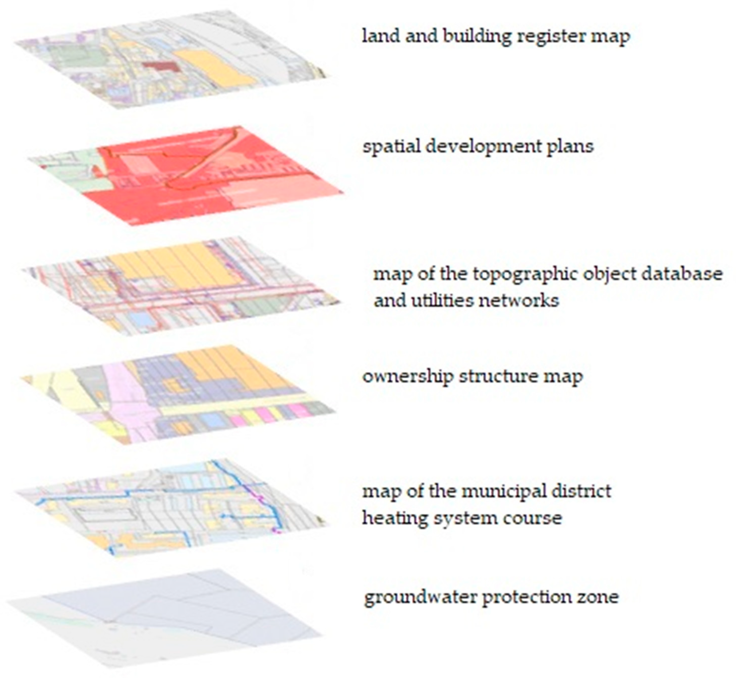
The “Urban space and planning” portal is GIS systems addressed to sectoral users involved in investments and city development. It contains the range of data used by land surveyors, property valuers, real estate brokers, property managers, and developers. The portal is also important to city authorities in terms of decisions concerning the location of investment projects, which implement public objectives. It comprises six thematic layers: Land and Property Register, spatial planning, principal map, ownership structure, municipal district heating system, and groundwater protection zones (Figure 1). The indicated layers contain necessary data used in decision-making analyses to determine the validity of the selection of the municipal waste incineration plant location in the context of environmental protection.
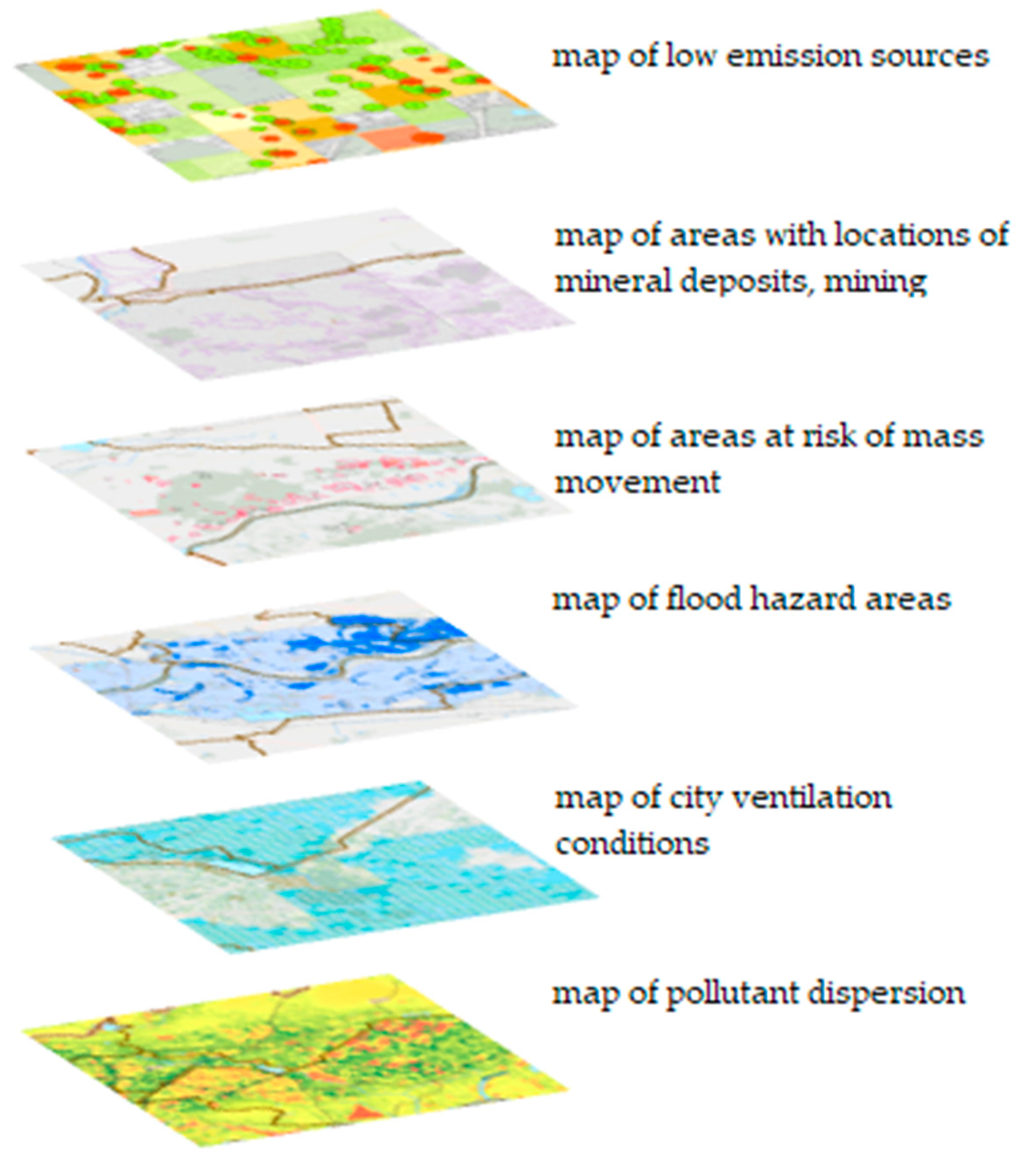
Another portal called “Environmental management and protection” contains data provided by the Department of Environmental Management of the Kraków City Council. The data contained in the portal enable obtaining information on the condition of the environment and its changes concerning various natural or anthropogenic phenomena occurring in the city of Kraków. Detailed data concern the level of pollution within the city area and the protected areas, and the decisions and preventive measures taken with the aim to increase the quality of the environment in the city. The portal “Environmental management and protection” contains the following spatial datasets: Location of low emission sources and the results of work related to their elimination, geological layers containing locations of mineral deposits, mining areas, water intake points, areas of mass movement, flood hazard including water depth, and data on air pollution (Figure 2).
The complete range of information necessary for the conducted study in terms of the use of data concerning the environmental pollution for the assessment of the selection of the location of municipal waste incineration plant, available via the above-mentioned portals developed as part of the Municipal Spatial Information System, is presented in Table 1.
The information presented in Table 1 indicates that the spatial information system of the city of Kraków provides a full range of data required in the assessment of the selection of locations for a municipal waste incineration plant. These data were used in further research.
3. Materials and Methods
The method of research involving the assessment of the validity of the selection of the location for the construction of a waste incineration plant, proposed in this paper, was implemented in five stages, according to the algorithm shown in Figure 3.
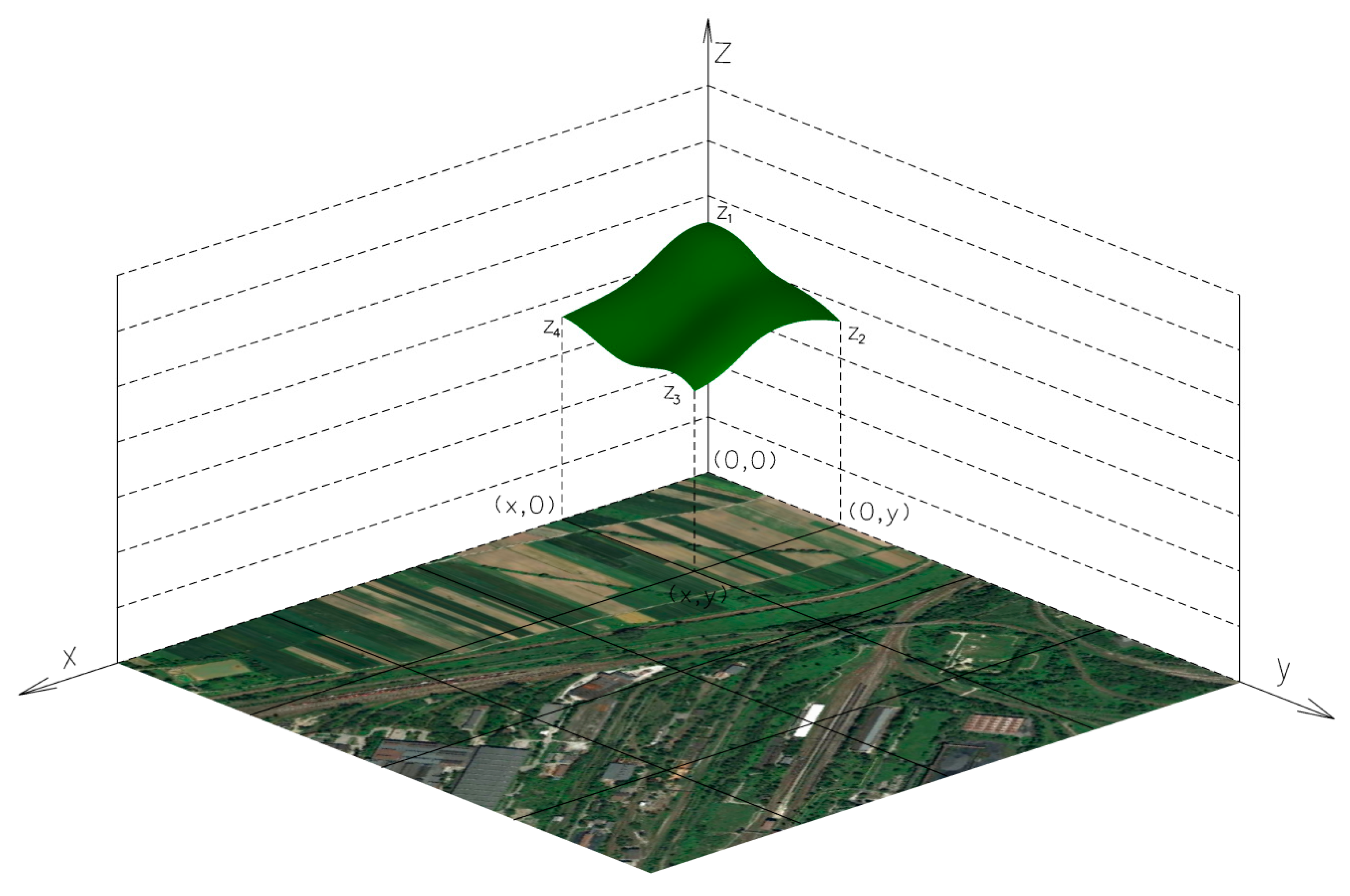
Stage I included the indication of factors describing the requirements and effects of the waste incineration plant location. In this case, the requirements were related to technical, legal, and economic conditions, while the effects referred to environmental factors (protection of the air, water, and soils; noise; protection of environmentally valuable areas, residential, and agricultural areas, etc.). The next stage (II) involved the establishment of an interpolation network over the analyzed area. In the nodal points of the network, data on the values of indicated factors need to be acquired. The factor values were the components of the third dimension, the investment space (Figure 4).
Values of particular factors, obtained from the infrastructure for spatial information, were expressed in various units. In order for them to be used in the analysis, they needed to be normalized. Linear normalization was applied, according to the following formulas:
where: i = 1,2,3, …, n, j = 1,2,3, …, m, I is a set of desirable maximum values, J is a set of desirable minimum values.
The factors listed above were characterized by various impacts, and therefore required proper weighting (Stage III). The weighting of factors was carried out by the analytic hierarchy process. Currently, this method is increasingly applied in many fields of science as well as in the performance of practical tasks. The most common applications include forecasting and planning in engineering [31,32,33], real estate management [34], economics [35], and administration, at both the local and central level [36]. The advantage of the method is the opportunity to compile, as part of an individual decision-making process, many various criteria that are described either numerically or verbally [37,38,39,40]. The AHP is also applied to calculate factor weights in analyses concerning the identification of optimal locations for industrial waste storage and the construction of municipal waste incineration plants [12,13].
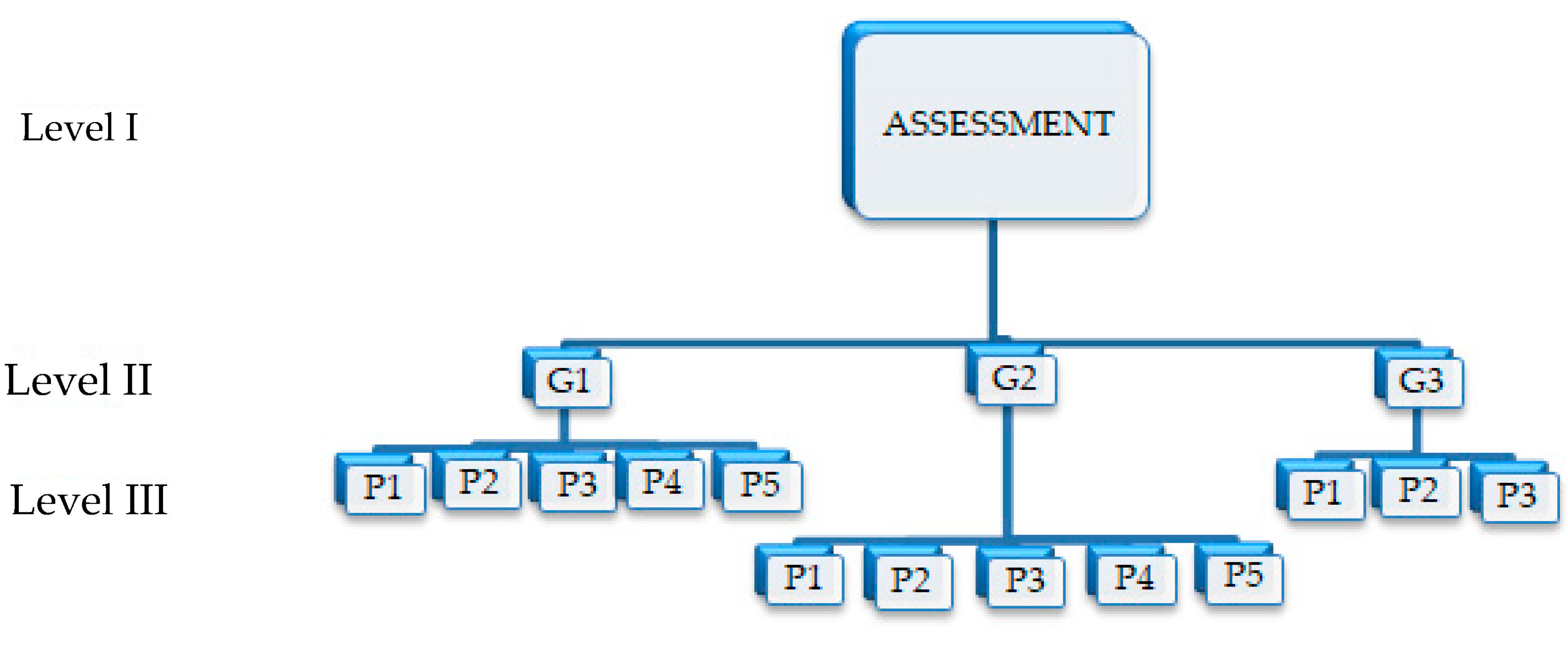
The Analytic Hierarchy Process is a mathematical method developed by Saaty and applied to solve multi-criteria decision-making problems. The first and, at the same time, the main component of the method is the structure of a problem in a hierarchical form. The primary aim is placed on the top of the hierarchy (level I), the next level (level II) is occupied by the criteria (specified in this paper as groups of factors), and the next level (III) included sub-criteria (factors). For the determination of weights (partial priorities) of hierarchy components located at a particular level, the pairwise comparison method was applied. These comparisons are a numerical representation of the relationships between two criteria of a particular level, and are aimed at estimating partial priorities (weights) of criteria at a particular level [31,41,42].
The analytical argument providing a basis for the operation of the AHP was an n-dimensional square matrix (n - the number of criteria taken into account in the analysis at a given hierarchy level):
where w1, w2, …, wn are values of particular criteria.
Matrix A is a square matrix with values of ones on the diagonal. Above the diagonal, there are scorings, which are the result of pairwise comparison, and below the diagonal there are the opposites of these scorings. This characteristic matrix type enables obtaining the solutions that are sought after, including the maximum eigenvalue of matrix λmax and an eigenvector corresponding to this eigenvalue. The eigenvector components are partial priorities (weights), and their combinations from all levels offer priorities of the solution alternatives.
The weight values from the matrix perspective are vector w, which is the solution of equation [41]:
where λmax is the maximum real eigenvalue of matrix A, and w is the eigenvector for this eigenvalue.
The correctness of the conducted paired comparison assessment of the criteria indicated in the analysis is verified by calculating, for each matrix A, the consistency index CI and the consistency ratio CR [41]:
where: n – matrix dimension, λmax – maximum matrix eigenvalue.
To check if paired comparison assessment of the criteria is consistent, Saaty proposed what is called the Consistency Ratio, which is a comparison between Consistency Index and Random Consistency Index (RI). If the value of Consistency Ratio is smaller or equal to 10%, the inconsistency is acceptable. If the Consistency Ratio is greater than 10%, we need to revision our paired comparison assessment of the criteria.
where: RI is a random consistency index (Table 2) determined by the matrix dimension [43].
After determining all partial priorities, the solution of the task is vector:
where:
C[1,k]—the resultant vector of weight parameters of the criteria assigned to the components of the hierarchical level k (i.e., the alternatives of solutions) in relation to the aim, namely the first level,
Bi—the matrix of level i, whose columns are vectors of priorities of the components of this level in relation to the components of level i – 1.
The weights calculated using the AHP (stage III) were used to calculate the coefficient of area suitability (LR) according to the algorithm presented in Table 3 (stage IV).
At each point of the network, the LR coefficient was calculated according to the formula:
where: k—factor weight; w—standardized factor value (stage II).
The values of factors between the network nodes were interpolated using bilinear interpolation. The tabular function form in which f1, …, fn is the function of distribution of a particular factor, while k1, …, kn indicates the weight of a particular factor. The last stage (stage V) is presenting results on the map.
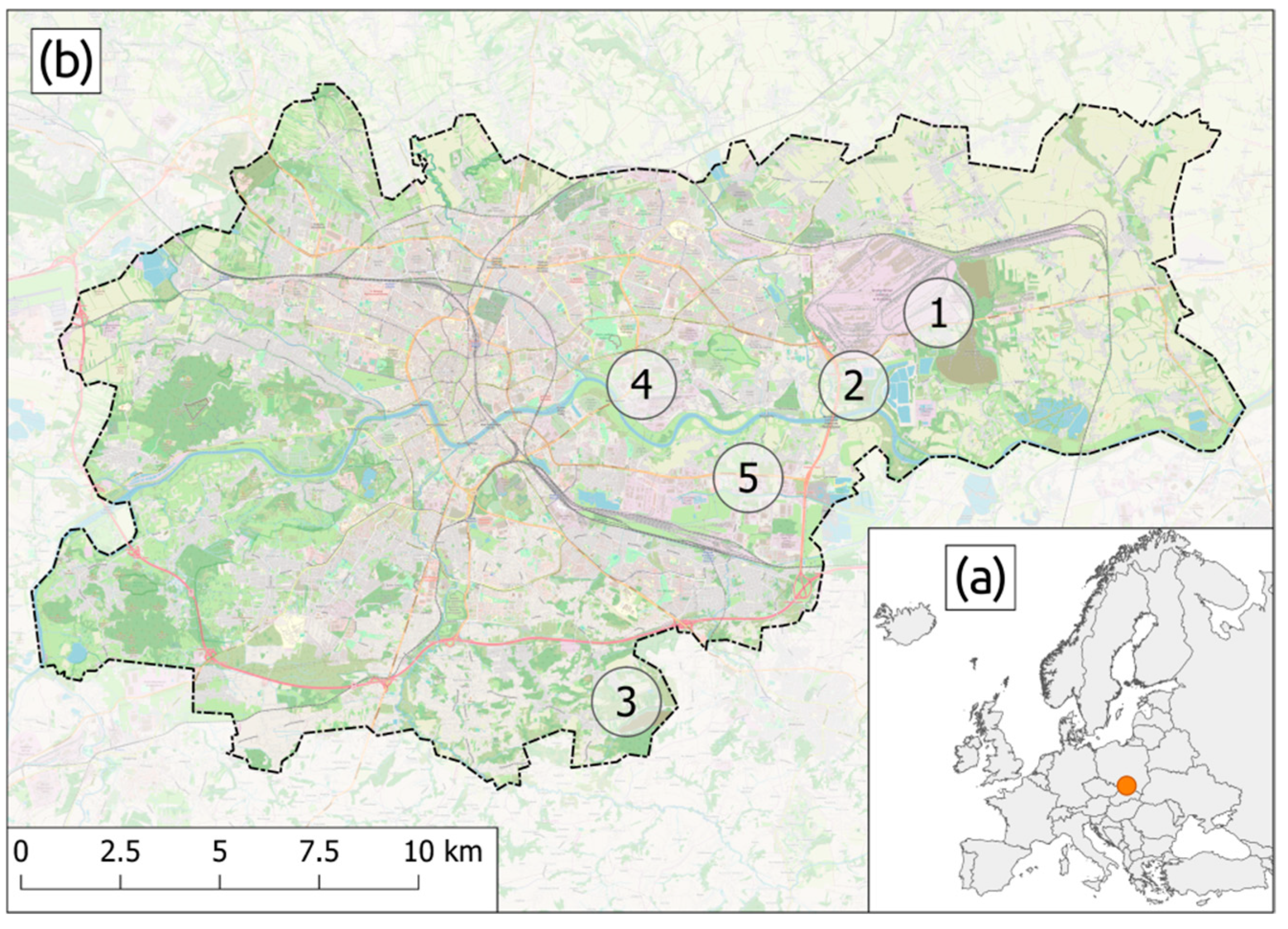
The study was conducted in the city of Kraków, where the city authorities indicated five potential locations for the construction of a municipal waste incineration plant (Figure 5). The first facility (Facility 1) is located at the ArcelorMittal Poland steel plant in Kraków; the second facility (Facility 2) is located in the vicinity of the Kujawy sewage treatment plant; the third facility (Facility 3) is an area located in the vicinity of the currently operating Barycz landfill; the fourth facility (Facility 4) is located near the Kraków combined heat-and-power plant; and the fifth facility (Facility 5) is located on the area of Kraków tannery. These actions resulted from the obligation to perform the tasks set out in the EU Directive [43] on waste management and environmental protection. The location of such a facility requires that technical factors be taken into account along with social and environmental factors [44,45].
For the purposes of the study, three groups of factors were indicated (Table 4). The first group includes technical data; the second group comprises factors related to the protection of natural environment, while the third one includes social factors related to the protection of residential areas, green areas (parks), and agriculturally developed areas. Using the information available in the local spatial information system for the city of Kraków, data were collected and an assessment of the analyzed areas was conducted in terms of their suitability for the construction of a municipal waste incineration plant, taking account of the indicated factors.
The factors mentioned in Table 4 were assessed for their impact on the analysis result. By applying the AHP, the weight of each factor was calculated. Figure 6 presents the hierarchy diagram. The first level is the aim of the study, including the indication of the degree of particular factors’ impact on the optimization of decision analyses concerning the selection of the waste incineration plant location. The second level includes groups of factors, while the third level includes all factors relevant to the analysis being carried out.
The structure thus constructed was the basis for the formation of the paired comparison matrix for each level. For each matrix, the eigenvalue was calculated; an assessment of consistency was conducted, and the priority vector was calculated as a normalized eigenvector for the maximum real eigenvalue. The results of these calculations are presented in Table 5.
The conducted empirical research demonstrated that, with regards to the groups of factors, the first group played the dominant role. These were technical factors (49.61%). The next group was the one that characterized factors related to environmental protection (31.01%), and the group of the factors which characterized the protection of agricultural, residential, and environmentally valuable areas (19.38%) had the smallest weight. However, the global distribution of weights varied. The distance to heating networks (18.79%) had the greatest weight; it was followed by access to trunk roads (16.16%) and dust pollution of the air (13.91%) as well as the distance to residential areas (10.49%). Factors such as the distance to the utilities network/energy network and gas pollution of the air obtained weights at a level of 8% and 9%, while environmentally valuable areas, geological conditions, and water pollution obtained weights at a level of 4%-5%. The other factors obtained weights of below these values.
4. Study Results and Discussion
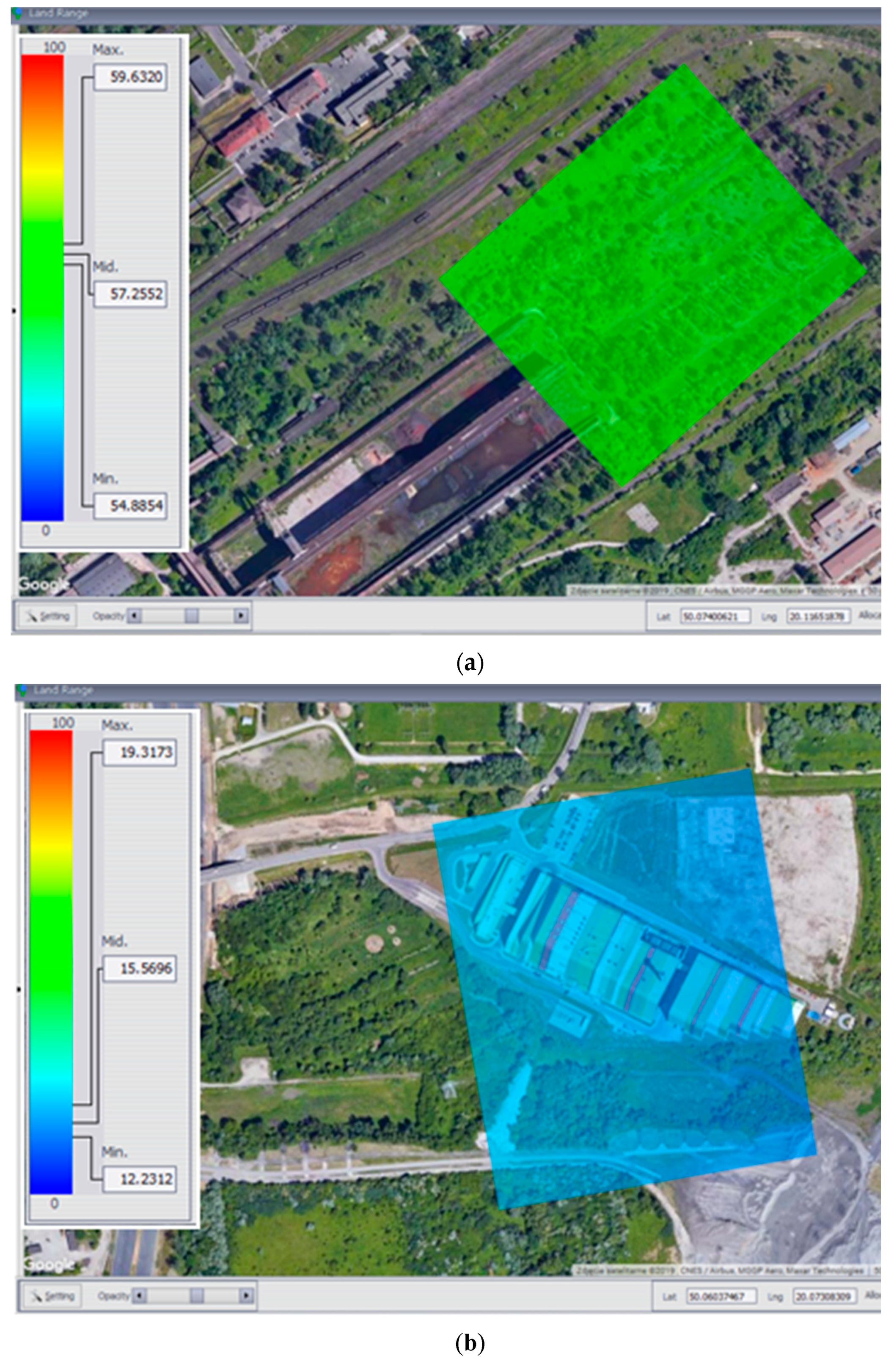
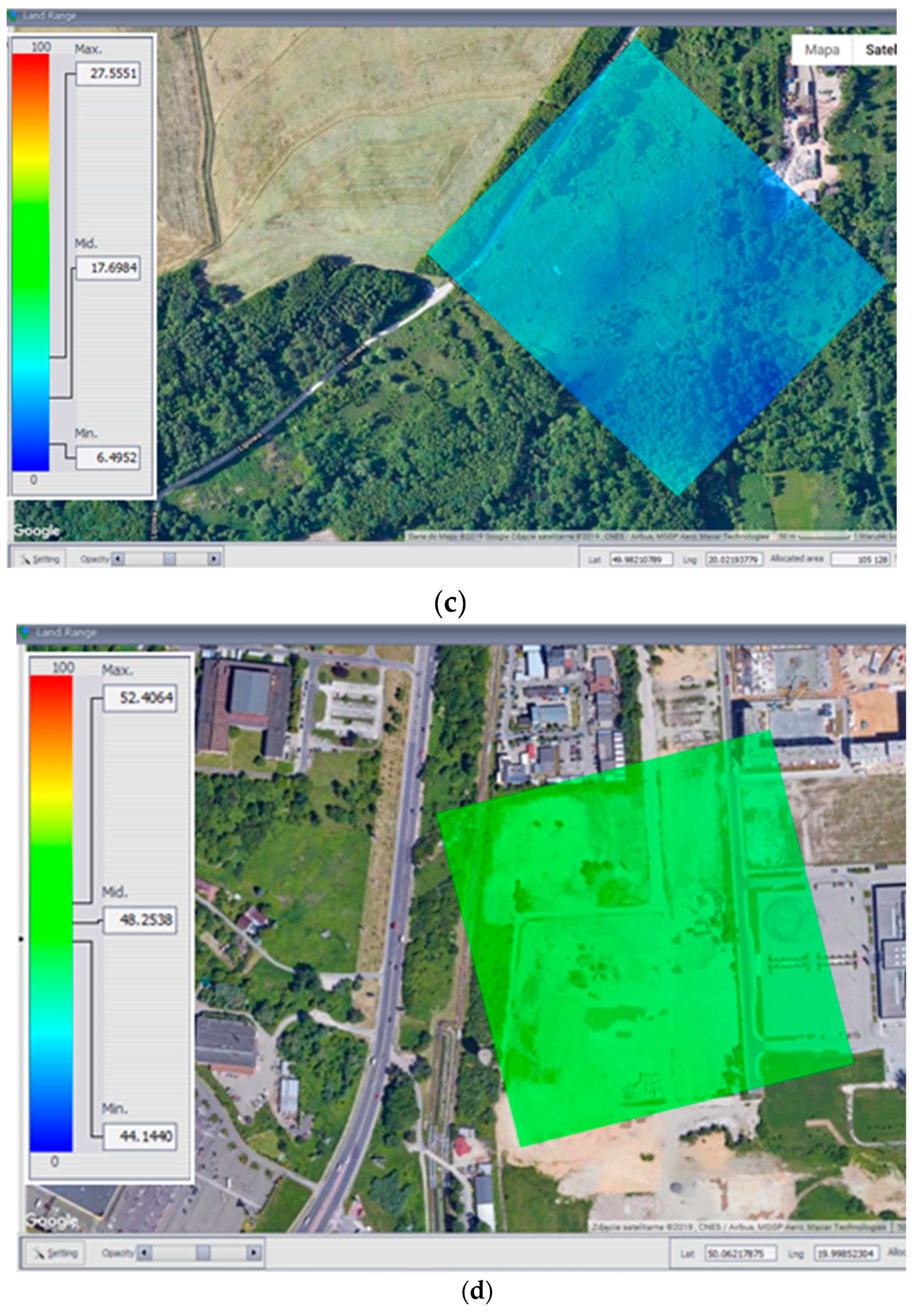
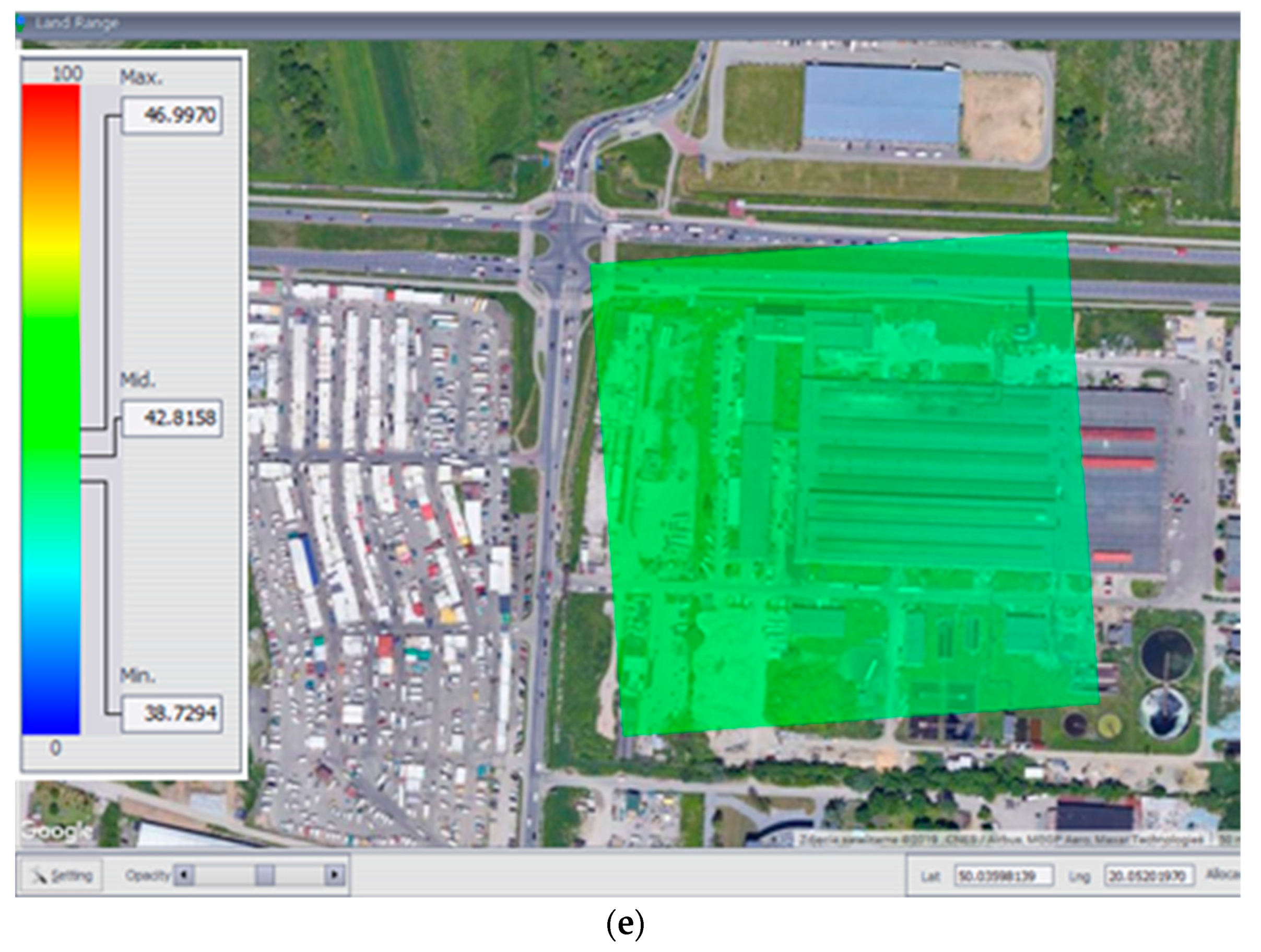
Using the data acquired from the spatial information system for the city of Kraków with regards to the values of factors listed in Table 4, the calculated weights and the algorithm presented in Table 3, the ranking of selected areas in terms of suitability for the construction of a municipal waste incineration plant was established. The results of the conducted analysis in the form of the coefficient of area suitability for the location of a municipal waste incineration plant are shown in Figure 7a–e. The aim of the study was to establish the ranking of the five analyzed facilities with relatively small areas of a few hectares, therefore the variability of factors in the particular area was low and noticeable only on the color scale. However, the differences between the analyzed facilities were clearly seen, therefore it was easy to indicate the facility that is potentially the best in the implementation of such an infrastructure project.
For the five analyzed facilities, the coefficient values ranged from 6.4952 to 59.6320, with the maximum value of 100. The coefficient distribution within the indicated range was shown by the color mask. The first facility obtained the highest score. For this facility, the mean value of the coefficient was 57.2552, with the minimum value of 54.8854 and the maximum value of 59.6320. This means that this area is potentially the best location for the construction of a waste incineration plant. For other facilities, the mean values of area suitability coefficients were lower, and ranged from 16% (the fourth facility) to 74% (the second facility).
Table 6 lists mean, minimum, and maximum values of the area suitability coefficient for the analyzed areas.
Facilities 1, 4, and 5 are located in industrial areas, in close proximity to the utility network, including to the main heating network, which enables the recovery of heat energy from waste heat. What is more, these facilities are located in the vicinity of main roads in the city and are not directly adjacent to residential buildings; hence, the coefficients calculated for these areas were similar and the highest. On the other hand, facilities 2 and 3 are located close to green and agricultural areas. These facilities have no direct access to the main public road network or to the utilities network, and in particular to the heating network that enables heat energy recovery.
At this point, it should be emphasized that the research aimed at the selection of the location of the infrastructure investment concerned (municipal waste incineration plant) should be carried out taking into account the maximization of potential possibilities for energy recover from heat waste while including the minimization of social barriers and potential damage to the natural environment. Two contrast examples can be shown at this point. One of them is a modern waste incineration plant in Vienna (the Spittelau waste incineration plant in Vienna), currently regarded as an “environmentally friendly facility”, and another one includes waste incineration plants in Wuhan (China), where, as reported by [44], economic benefits are given priority over the environmental protection rules.
Decisions concerning the location of an investment project, taken by government administration bodies at various levels, have a significant effect on the application of sustainable development principles. These principles are understood here as the integration of economic and social activities (implementation of new technologies serving to increase the living standards of people) with maintaining the principles of balance in nature. One of the basic activities of introducing the principles of sustainable development is to grassroot the processes of making decisions related to the interference in local natural environment. In the sustainable development, the natural environment is the backbone of activities, therefore its protection is particularly important in terms of maintaining conditions that are favorable to physical, psychological, and social development of both the present generation and the future ones.
Therefore, in order to avoid, or at least minimize the adverse effects of decisions related to the wrong location of such facilities e.g., a municipal waste incineration plant, they must be taken based on the previously conducted analyses. As reported by [44], there is more and more evidence that decisions concerning the construction of new infrastructure are challenged by the public mainly on environmental grounds. There is therefore a clear need for scientific research into the development of a methodology to facilitate and streamline the decision-making processes [46].
5. Conclusions
Decision analyses concerning the assessment of validity of the selection of the location for the construction of an infrastructure such as a waste incineration plant require a number of factors addressing the consequences of the impact of such a facility on the inhabitants and the environment to be considered.
The algorithm proposed in the study enabled the determination of the ranking of five indicated research facilities in terms of their suitability for the construction of a municipal waste incineration plant within the city of Kraków. The study results were visualized using a color mask, and the range of the coefficient for a particular area can be read from the scale value.
The developed application can also be used to indicate areas with various degrees of suitability for the implementation of a particular investment project, which is the starting point for environmental discussions. It also allows the areas whose suitability has been determined at a level lower than that indicated by the decision-maker to be excluded from analysis.
The solution proposed in the paper, which concerns the calculation of the coefficient of area usefulness for the location of a particular investment project, is only effective when the person carrying out the analysis has access to complete and reliable information. As indicated by the study conducted for the Kraków city area, web mapping services available as part of the ISI contain complete data necessary for carrying out research concerning an assessment of the validity of selection of the location for a municipal waste incineration plant. High quality, timeliness and unrestricted access to the data collected in them increase the accuracy of the obtained results of decision analyses.
In the 21st century, there has been a rapid development of technology and accessibility of research tools (GIS). Remote sensing data, currently acquired and made available to the users, may be a basis for multi-criteria geospatial analyses, inter alia for the purposes of environmental protection and management and the protection of cultural landscapes.
The presented analytic hierarchy process can be successfully applied to assess the location of various infrastructural investment projects including roads, railway lines, wastewater treatment plants, sports facilities, wind farms, etc. The future work is aimed at carrying out research into the implication of AHP into ISI, which may contribute to the implementation of the "semantic web" idea in order to develop the spatial information intelligent infrastructure.
Author Contributions
All research was conducted by M.S. The paper was prepared and developed by M.S. All authors have read and agreed to the published version of the manuscript.
Funding
This research was created as part of the statutory research of the Department of Land Surveying, University of Agriculture in Kraków, No. SUB/2019 - 0318000000-D310.
Conflicts of Interest
All research was conducted by M.S.
References
- Adamović, V.M.; Antanasijević, D.Z.; Ćosović, A.R.; Ristić, M.D.; Pocajt, V.V. An artificial neural network approach for the estimation of the primary production of energy from municipal solid waste and its application to the Balkan countries. Waste Manag. 2018, 78, 955–968. [Google Scholar] [CrossRef]
- Alobaid, F.; Al-Maliki, W.A.K.; Lanz, T.; Haaf, M.; Brachthäuser, A.; Epple, B.; Zorbach, I. Dynamic simulation of a municipal solid waste incinerator. Energy 2018, 149, 230–249. [Google Scholar] [CrossRef]
- Chen, Y.C.H. Evaluating greenhouse gas emissions and energy recovery from municipal and industrial solid waste using waste-to-energy technology. J. Clean. Prod. 2018, 192, 262–269. [Google Scholar] [CrossRef]
- Vaverková, M.D. Landfill Impacts on the Environment—Review. Geosciences 2019, 9, 431. [Google Scholar] [CrossRef] [Green Version]
- Ersoy, H.; Bulut, F. Spatial and multi-criteria decision analyses based methodology for landfill site selection in growing urban regions. Waste Manag. Res. 2009, 27, 489–500. [Google Scholar] [CrossRef]
- Khamehchiyan, M.; Reza, N.M.; Boroumandi, M. Identification of hazardous waste landfill site: A case study from Zanjan province, Iran. Environ. Earth Sci. 2011, 64, 1763–1776. [Google Scholar] [CrossRef]
- Wu, Z.; Chen, Y. The Maximizing Deviation Method for Group Multiple Attribute Decision Making under Linguistic Environment. Fuzzy Sets Syst. 2007, 158, 1608–1617. [Google Scholar] [CrossRef]
- Siejka, M. The role of spatial information systems in decision-making processes regarding investment site selection. Real Estate Manag. Valuat. 2017, 25, 62–72. [Google Scholar] [CrossRef] [Green Version]
- Yoxas, G.; Samara, T.; Sargologou, L.; Stournaras, G. Multiple criteria analysis for selecting suitable sites for construction of sanitary landfill based on hydrogeological data; Case study of Kea Island (Aegean Sea, Hellas). Adv. Res. Aquat. Environ. 2011, 2, 97–104. [Google Scholar] [CrossRef]
- Zelenović-Vasiljević, T.; Srdjević, Z.; Bajčetić, R.; Vojinović-Miloradov, M. GIS and the Analytic Hierarchy Process for Regional Landfill Site Selection in Transitional Countries: A Case Study from Serbia. Environ. Manag. 2012, 49, 445–458. [Google Scholar] [CrossRef]
- Joerin, F.; Musy, A. Land management with GIS and multicriteria analysis. Int. Trans. Oper. Res. 2000, 7, 67–78. [Google Scholar] [CrossRef]
- Tavares, G.; Zsigraiová, Z.; Semiao, V. Multi-criteria GIS-based siting of an incineration plant for municipal solid waste. Waste Manag. 2011, 31, 1960–1972. [Google Scholar] [CrossRef]
- Pérez, M.; Rodrigo Estay, R.; Encina, V. Dynamic Spatial Modeling of Optimal Locations for Territorial Planning Ordering of the Industrial Waste in a Mining City. Proceedings 2018, 2, 1292. [Google Scholar] [CrossRef] [Green Version]
- Siejka, M. Public purpose investments site selection in real estate management - case study in Poland. In Proceedings of the 16th International Multidisciplinary Scientific GeoConference SGEM 2016, Albena Resort, Bulgaria, 28 June–7 July 2016; pp. 503–510. [Google Scholar] [CrossRef]
- Ak, H.; Braida, W. Sustainable municipal solid waste management decision making. Manag. Environ. Qual. 2015, 26, 909–928. [Google Scholar] [CrossRef]
- De Man, W.H.E. Are spatial data infrastructures special? In Research and Theory in Advancing Spatial Data Infrastructure Concepts; Onsrud, H., Ed.; ESRI Press: Redlands, CA, USA, 2007; pp. 7–31. [Google Scholar]
- Masser, I. GIS worlds: Creating Spatial Data Infrastructures; ESRI Press: Redlands, CA, USA, 2005. [Google Scholar]
- Sridharan, N. Can smart city be an inclusive city?—Spatial targeting (ST) and Spatial data infrastructure (SDI). In E-governance for Smart Cities; Vinod Kumar, T.M., Ed.; Springer: Singapore, 2015; pp. 233–244. [Google Scholar]
- Van Manen, N.; Scholten, H.J.; Van De Velde, R. Geospatial technology and the role of location in science. In Geospatial Technology and The Role of Location in Science; Scholten, H.J., Velde, R., Manen, N., Eds.; Springer: Dordrecht, The Netherlands, 2009; Volume 96, pp. 1–13. [Google Scholar]
- López-Toro, A.A.; Rubio-Romero, J.C.; Suárez-Cebador, M.; Arjona-Jiménez, R. Consideration of stakeholder interests in the planning of sustainable waste management programmes. Waste Manag. Res. 2016, 34, 1036–1046. [Google Scholar] [CrossRef]
- Chang, N.B.; Parvathinathan, G.; Breeden, J.B. Combining GIS with fuzzy multicriteria decision-making for landfill siting in a fast-growing urban region. J. Environ. Manag. 2008, 87, 139–153. [Google Scholar] [CrossRef]
- Singh, A. Remote sensing and GIS applications for municipal waste management. J. Environ. Manag. 2019, 243, 22–29. [Google Scholar] [CrossRef]
- Shaikh, M.A.; Muhammad, H.; Sivertun, A. Solid Waste Management Planning using GIS and Remote Sensing Technologies Case Study Aurangabad City, India. In Proceedings of the 2006 International Conference on Advances in Space Technologies, Islamabad, Pakistan, 2–3 September 2006; pp. 196–200. [Google Scholar] [CrossRef]
- Sener, S.; Sener, E.; Nas, B.; Karagüzel, R. Combining AHP with GIS for landfill site selection: A case study in the Lake Beysehir catchment area (Konya, Turkey). Waste Manag. 2010, 30, 2037–2046. [Google Scholar] [CrossRef]
- Vahidnia, M.H.; Alesheikh, A.A.; Alimohammadi, A. Hospital site selection using fuzzy AHP and its derivatives. J. Environ. Manag. 2009, 90, 3048–3056. [Google Scholar] [CrossRef]
- Rahmat, Z.G.; Niri, M.Z.; Alavi, N.; Goudarzi, G.; Babaei, A.A.; Baboli, Z.; Hosseinzadeh, M. Landfill Site Selection using GIS and AHP: A Case Study: Behbahan, Iran. KSCE J. Civ. Eng. 2017, 21, 111–118. [Google Scholar] [CrossRef]
- Directive 2007/2/EC of the European Parliament and of the Council of 14 March 2007 Establishing an Infrastructure for Spatial Information in the European Community (INSPIRE). Available online: http://data.europa.eu/eli/dir/2007/2/2019-06-26 (accessed on 21 October 2019).
- Act on Spatial Information Infrastructure of 4 March 2010. J. Laws. 2010. No. 76, item 489, as amended. Available online: http://prawo.sejm.gov.pl/isap.nsf/download.xsp/WDU20100760489/U/D20100489Lj.pdf (accessed on 10 September 2019).
- Ślusarski, M. Analysis of underground utility networks damage risk in the context of spatial data quality. In Proceedings of the 16th International Multidisciplinary Scientific Geoconference SGEM 2016, Albena Resort, Bulgaria, 28 June–7 July 2016; pp. 35–41. [Google Scholar] [CrossRef]
- Siejka, M. Optimal Selection of Investments Location in Land Management; Polish Academy of Sciences, Infrastructure and Ecology of Rural Areas: Kraków, Poland, 2015; Volume IV, p. 129. (In Polish) [Google Scholar]
- Rao, R.V. Decision Making in the Manufacturing Environment Using Graph Theory and Fuzzy Multiple Attribute Decision Making Methods; Springer: London, UK, 2007; p. 372. [Google Scholar]
- Fusco Girard, L.; Cerreta, M.; De Toro, P. Analytic hierarchy process (AHP) and geographical information systems (GIS): An integrated spatial assessment for planning strategic choices. Int. J. Anal. Hierarchy Process 2012, 4. [Google Scholar] [CrossRef]
- Triantaphyllou, E.; Mann, S. Using the analytic hierarchy process for decision making in engineering applications: Some challenges. Int. J. Ind. Eng. Theory Appl. Pract. 1995, 2, 35–44. [Google Scholar]
- Jiang, G.M.; Hu, Z.P.; Jin, J.V. Quantitative Evaluation of Real Estate’s Risk based on AHP and Simulation. Syst. Eng. Theory Pract. 2007, 9, 77–81. [Google Scholar] [CrossRef]
- Mardle, S.; Pascoe, S.; Herrero, I. Management objective importance in fisheries: An evaluation using the analytic hierarchy process (AHP). Environ. Manag. 2004, 33, 1–11. [Google Scholar] [CrossRef]
- Jabbarzadeh, A. Application of the AHP and TOPSIS in project management. J. Proj. Manag. 2018, 3, 125–130. [Google Scholar] [CrossRef]
- Wójcik-Leń, J.; Leń, P.; Mika, M.; Kryszk, H.; Kotlarz, P. Studies regarding correct selection of statistical methods for the needs of increasing the efficiency of identification of land for consolidation—A case study in Poland. Land Use Policy 2019, 87, 104064. [Google Scholar] [CrossRef]
- Hamalainen, R.P.; Lindstedt, M.R.; Sinkko, K. Multiattribute risk analysis in nuclear emergency management. Risk Anal. 2000, 20, 455–467. [Google Scholar] [CrossRef] [Green Version]
- Sirikijpanichkul, A.; Ferreira, L. Multi-Objective Evaluation of Intermodal Freight Terminal Location Decisions. In Proceedings of the 27th Conference of Australian Institute of Transport Research (CAITR), Queensland University of Technology, Brisbane, Australia, 7–9 December 2005. [Google Scholar]
- Salo, A.; Hämäläinen, R.P. Multicriteria Decision Analysis in Group Decision Processes. In Handbook of Group Decision and Negotiation. Advances in Group Decision and Negotiation; Kilgour, D., Eden, C., Eds.; Springer: Dordrecht, The Netherlands, 2010; Volume 4, pp. 269–283. [Google Scholar]
- Saaty, T.L. The Analytical Hierarchy Process; International Book Company McGraw-Hill: New York, NY, USA, 1980. [Google Scholar]
- Saaty, T.L. Fundamentals of Decision Making and Priority Theory with the AHP; RWS Publications: Pittsburg, CA, USA, 2000. [Google Scholar]
- Directive 2008/98/EC of the European Parliament and of the Council of 19 November 2008 on Waste and Repealing Certain Directives. Available online: http://data.europa.eu/eli/dir/2008/98/2018-07-05 (accessed on 21 October 2019).
- Kirkman, R.; Voulvoulis, N. The role of public communication in decision making for waste management infrastructure. J. Environ. Manag. 2017, 203, 640–647. [Google Scholar] [CrossRef]
- Hu, H.; Li, X.; Nguyen, A.D.; Kavan, P. A Critical Evaluation of Waste Incineration Plants in Wuhan (China) Based on Site Selection, Environmental Influence, Public Health and Public Participation. Int. J. Environ. Res. Public Health 2015, 12, 7593–7614. [Google Scholar] [CrossRef] [Green Version]
- Kharat, M.; Raut, R.; Kamble, S.S.; Kamble, S.J. The application of Delphi and AHP method in environmentally conscious solid waste treatment and disposal technology selection. Manag. Environ. Qual. 2016, 27, 427–440. [Google Scholar] [CrossRef]
Figure 1.
Map layers in the “Urban space and planning” infrastructure for spatial information ISI. Source: Own research based on www.msip.um.krakow (accessed on 25 September 2019).
Figure 1.
Map layers in the “Urban space and planning” infrastructure for spatial information ISI. Source: Own research based on www.msip.um.krakow (accessed on 25 September 2019).

Figure 2.
Map layers in the “Environmental management and protection” ISI. Source: Own research based on www.msip.um.krakow (accessed on 25 September 2019).
Figure 2.
Map layers in the “Environmental management and protection” ISI. Source: Own research based on www.msip.um.krakow (accessed on 25 September 2019).

Figure 3.
Algorithm of the data use, contained in spatial information systems, for the rating of the selection of municipal waste incineration plant location - research work stages.
Figure 3.
Algorithm of the data use, contained in spatial information systems, for the rating of the selection of municipal waste incineration plant location - research work stages.

Figure 4.
Spatial distribution of a particular factor within the area of a single interpolation network mesh. Source: own research based on [14].
Figure 4.
Spatial distribution of a particular factor within the area of a single interpolation network mesh. Source: own research based on [14].

Figure 5.
Siting of research facilities: (a) At the background of Europe, (b) in the city of Krakow, the numbers represent individual facilities. Source: Own research.
Figure 5.
Siting of research facilities: (a) At the background of Europe, (b) in the city of Krakow, the numbers represent individual facilities. Source: Own research.

Figure 6.
Diagram of the hierarchy structure.

Figure 7.
The value of the coefficient of area suitability for the location of a municipal waste incineration plant—(a–e): Facility 1–5.
Figure 7.
The value of the coefficient of area suitability for the location of a municipal waste incineration plant—(a–e): Facility 1–5.


Table 1.
Matrix of the data available in the Kraków Municipal Spatial Information System.
| Type of Information | Portal | |
|---|---|---|
| Urban Space and Planning | Environmental Management and Protection | |
| Administrative division | + | + |
| Land and Property Register | + | + |
| Land in use and valuation classes | + | + |
| Transport | + | + |
| Land development | + | |
| Utilities | + | + |
| Geodetic control network | + | |
| Ownership structure | + | |
| Spatial planning | + | |
| Historic monuments of the city of Kraków | + | |
| Hydrography | + | |
| Geology | + | + |
| Landslides - mass movement | + | + |
| Nature protection | + | + |
| Vegetation | + | + |
| Demography | + | + |
| Local renewal programs | + | |
| Municipal district heating system | + | |
| Flood hazards | + | |
| Low emission sources | + | |
| Inventory of green areas | + | |
| Map of area coverage and terrain roughness | + | |
| Map of green areas and Kraków ventilation conditions | + | |
| Map of natural evaluation | + | |
| Map of average anemological conditions | + | |
| Map of average pollutant dispersion conditions | + | |
Source: Own research based on www.msip.um.krakow.pl.
Table 2.
The random consistency index value depending on the size of the matrix.
| n | 1 | 2 | 3 | 4 | 5 | 6 | 7 | 8 | 9 | 10 | 11 | 12 | 13 | 14 | 15 |
| RI | 0 | 0 | 0.58 | 0.90 | 1.12 | 1.24 | 1.32 | 1.44 | 1.45 | 1.49 | 1.51 | 1.53 | 1.56 | 1.57 | 1.59 |
Source: based on [42].
Table 3.
Algorithm in a tabular form.
| k1·f1(0,0) + k2·f2(0,0) + + …, kn·fn (0,0) | k1·f1(1,0) + k2·f2(1,0) + … + kn·fn (1,0) | … | … | … |
| k1·f1(0,1) + k2·f2(0,1) + … + kn·fn (0,1) | … | … | … | … |
| … | … | … | … | … |
| … | … | … | … | k1·f1(3,4) + k2·f2(3,4) + … + kn·fn (3,4) |
Table 4.
Factors concerning the location of a municipal waste incineration plant.
| Group of Factors G | Factor Type P | Factor Description |
|---|---|---|
| Technical G1 | utilities/heating network P1 | distance to utilities network [m] not wasting heat, so the shorter the distance to the main heat receiver network (Municipal District Heating Enterprise), the higher the index (heating network) |
| utilities/energy network P2 | distance to utilities network [m] not wasting energy, so the shorter the distance to the main energy receiver network, the higher the index (energy network) | |
| access to trunk roads P3 | distance to main public roads [m] easy road access for trucks or railways, so the shorter the distance to a road, the higher the index | |
| geological conditions/groundwater P4 | the quality of geological conditions expressed in point values whether the geological structure allows the construction of a building the better geological conditions and the lower groundwater level, the higher the index | |
| flood hazard P5 | distance to watercourses which pose a potential flood hazard [m] flood protection, the longer the distance to the river posing a flood hazard, the higher the index | |
| Environmental protection G2 | wind pattern P1 | scoring based on the analysis of the direction and magnitude of the winds typical of a particular area, whether the wind direction will carry pollution towards the city |
| dust pollution of the air P2 | current dust pollution of the air in terms of the possibility for introducing additional pollutants due to the location of the plant, minimize dust air pollution | |
| gas pollution of the air P3 | current gas pollution of the air in terms of the possibility for introducing additional pollutants due to the location of the plant, minimize gas air pollution | |
| water pollution P4 | current water pollution in terms of the possibility for introducing additional pollutants due to the location of the plant, minimize water pollution | |
| soil pollution P5 | current soil pollution in terms of the possibility for introducing additional pollutants due to the location of the plant, minimize soil pollution | |
| Protection of areas G3 | residential areas P1 | distance to residential areas [m] reduce the threat of pollution to residential areas, so the longer the distance to residential buildings, the higher the index |
| environmentally valuable areas P2 | distance to green areas, parks etc. [m] reduce the threat of pollution to environmentally valuable areas, so the longer the distance to green areas/parks, the higher the index | |
| agricultural areas P3 | distance to agricultural areas [m] reduce the threat of pollution to agricultural areas, so the longer the distance to areas used for agricultural purposes/garden plots, the higher the index |
Table 5.
Weight priorities at particular levels.
| Group of Factors | Partial Weights | Factors | Partial Weights | Global Weights |
|---|---|---|---|---|
| Technical - G1 | 0.4961 | utilities/heating network P1 | 0.3787 | 0.1879 |
| utilities/energy network P2 | 0.1641 | 0.0814 | ||
| access to trunk roads P3 | 0.3256 | 0.1616 | ||
| geological conditions/groundwater P4 | 0.0863 | 0.0428 | ||
| flood hazard P5 | 0.0452 | 0.0224 | ||
| Consistency assessment | ||||
| CI | 0.0768 | |||
| CR | 0.0686 | |||
| Environmental protection - G2 | 0.3101 | wind pattern - P1 | 0.0390 | 0.0121 |
| gas pollution of the air - P2 | 0.3011 | 0.0934 | ||
| dust pollution of the air - P3 | 0.4486 | 0.1391 | ||
| water pollution - P4 | 0.1439 | 0.0446 | ||
| soil pollution - P5 | 0.0674 | 0.0209 | ||
| Consistency assessment | ||||
| CI | 0.0639 | |||
| CR | 0.0570 | |||
| Protection of areas - G3 | 0.1938 | residential areas - P1 | 0.5412 | 0.1048 |
| environmentally valuable areas - P2 | 0.2965 | 0.0575 | ||
| agricultural areas - P3 | 0.1623 | 0.0315 | ||
| Consistency assessment | ||||
| CI | 0.0034 | |||
| CR | 0.0058 | |||
| Consistency assessment | ||||
| CI | 0.0233 | |||
| CR | 0.0401 | |||
Table 6.
Values of area suitability coefficients LR for the analyzed facilities.
| Specification | Area Suitability Coefficient | ||
|---|---|---|---|
| Minimum Value | Mean Value | Maximum Value | |
| Facility 1 | 54.8854 | 57.2552 | 59.6320 |
| Facility 2 | 12.2312 | 15.5696 | 19.3173 |
| Facility 3 | 6.4952 | 17.6984 | 27.5551 |
| Facility 4 | 44.1440 | 48.2538 | 52.4064 |
| Facility 5 | 38.7294 | 42.8158 | 46.9970 |
© 2020 by the author. Licensee MDPI, Basel, Switzerland. This article is an open access article distributed under the terms and conditions of the Creative Commons Attribution (CC BY) license (http://creativecommons.org/licenses/by/4.0/).
Share and Cite
MDPI and ACS Style
Siejka, M. The Use of AHP to Prioritize Five Waste Processing Plants Locations in Krakow. ISPRS Int. J. Geo-Inf. 2020, 9, 110. https://0-doi-org.brum.beds.ac.uk/10.3390/ijgi9020110
AMA Style
Siejka M. The Use of AHP to Prioritize Five Waste Processing Plants Locations in Krakow. ISPRS International Journal of Geo-Information. 2020; 9(2):110. https://0-doi-org.brum.beds.ac.uk/10.3390/ijgi9020110
Chicago/Turabian StyleSiejka, Monika. 2020. "The Use of AHP to Prioritize Five Waste Processing Plants Locations in Krakow" ISPRS International Journal of Geo-Information 9, no. 2: 110. https://0-doi-org.brum.beds.ac.uk/10.3390/ijgi9020110
Note that from the first issue of 2016, this journal uses article numbers instead of page numbers. See further details here.