1. Introduction
There are many ways to implement the cartographic modelling of geographical space, and it has many different applications. According to the contemporary cartographic, photogrammetric, and geographic information system (GIS) science [
1,
2,
3,
4], the primary method for modelling space and creating digital repositories for reference data is establishing topographic databases and digital terrain models using orthophoto maps. The process of creating digital terrain models more and more frequently uses 3D techniques, for example, to create three-dimensional models of buildings following the CityGML standards (with a level of detail (LoD) ranging from LoD1 to LoD4). The gathered topographic data, official or social (e.g., Open Street Map), serve many purposes, such as cartographic visualisation in geoportals or analysis using geographic information system (GIS) tools. However, reference data relatively rarely come into use for powering the production systems of electronic games. The main reason is the complexity of the importing process and the nature of most games embedded in fictional realities and worlds. Nevertheless, it is possible to utilise game engines to create visually stunning real-world models that enable a virtual exploration of new places, their analysis, or predicting changes in the usage of space.
The issue of using game engines to create virtual models of the real world may be particularly relevant to the creation and development of the so-called smart cities [
5,
6] and their “digital twins”. The use of mechanisms for the digital shaping of the city’s development in the game’s toolset environment not only enables exploring the space, but also poses “what if?” questions. How to expand cities so as not to cause congestion during the rush hours? How to use space efficiently so as not to cause environmental degradation? This is a particularly vital issue for so-called sustainable development.
One of the most effective ways to educate society on sustainable development is to utilise the techniques of gamification and so-called serious games [
7] (pp. 336) [
8,
9,
10,
11]. The primary purpose for creating serious games is not merely entertainment; “serious games” help the players in obtaining, developing, and consolidating specific skills, as well as problem-solving. They can also be used to inform on the role of social responsibility and the consequences of undertaking economic and social activities in the process of shaping or using space. Serious games can be used as tools, both to improve skills/performance and to broadcast messages [
12].
One of the goals of a serious game is creating a place for dialogue and discussion and, ultimately, shaping a properly functioning civil society that commonly utilises information technologies. In the Polish reality, social bonds fall within the confines of family and friends or, sometimes, neighbours. The CBOS (Public Opinion Research Center) has been researching neighbourly and social ties since the mid-1990s. The research shows that, although the transformation of such relationships is very slow, it can already be said that there are differences. At present, fewer people declare to maintain social contacts and do minor favors for each other than a dozen years ago. The level of trust in the (broadly-understood) business or local authorities has been building slowly. The problems with trust intensify with co-occurring economic or environmental problems. Creating a virtual model of the world and proposing rules of the game that support cooperation and teamwork may be an exciting way to resolve this issue. Such a serious game is an attempt at showing the need for change, also by calling attention to the real needs or expectations. Thus, contrary to what J. Huizinga [
13] claimed, the laws and customs of “ordinary life” do apply. Players—residents, authorities, or business representatives, among others—realise after a few turns that only through cooperation will they achieve the goals of individual interest groups as well as the common, strategic, and tactical goal.
According to R. Putnam [
14], trust or distrust between public life entities, as well as between individuals and institutions, is largely determined by historical experience. The relations between representatives of local authorities (local administration) and entrepreneurs may already be burdened with a not very "comfortable" baggage of historical experience.
Polish history may justify a dichotomous division into "we" (society) and "they" (representatives of the "enemy", for example, the invader, the occupant, the imposed order). Cooperation (working together towards common goals) requires mutual trust. The ideas of new public culture and local governance involve a significant shift from procedural, formal-legal administration to management by a partnership, where one of the key partners is entrepreneurs [
15].
One of the main goals of local government is to stimulate economic activity by creating conditions conducive to innovation and entrepreneurship. The role of officials becomes to initiate and stimulate change.
The trust means that people understand each other better and social processes run smoothly and without major misunderstandings. The already mentioned institution—CBOS (Public Opinion Research Center)—has been researching trust and the level of trust for over 17 years. In one of the research messages (NO. 35/2018, CBOS 2018), three-quarters of Poles are extremely cautious in dealing with people. More than half are suspicious of unknown people. The authors of the study noticed that the attitude of distrust in interpersonal contacts, since CBOS has conducted research on this issue, has never been so strong in Poles’ declarations. As for civic trust (for institutions operating in the state), Poles do not trust political parties and "politicized" institutions (not only by definition, but also from practice). Local governments, the President of the Republic of Poland, Commissioner for Human Rights, and the European Union enjoy a relatively high level of trust.
The authors of the article wanted to develop a prototype of a serious game in an environment of a professional game engine that, by using detailed topographic data to build a virtual model of the real world, will also enable consultations or social debates regarding the use of the space. The engine of Cities: Skylines (based on Unity) and the C# language served as the toolset environment, making it possible to develop a so-called mod that fully automates the process of importing official topographic data (spatial databases and a digital terrain model) into the game engine.
The rules of the game were repeatedly tested on a hex map and modified with GIS technology after conducting tests in which the residents participated. The implementation of selected game rules in the environment of Cities: Skylines and the analysis of the game’s capabilities constituted the final results of the works.
The article’s layout stems from the adopted objectives. Chapters 2 and 3 deal with related works, the problem definition, and proposals for a solution, respectively. Chapter 4 details the authorial “mod” developed using the C# programming language that enables an automatic import of official topographic data into the game engine. The final part of the article contains a summary of the performed analyses and a description of future research objectives.
2. Related Works
Computer games have been developed since the 1950s and have since become part of mass culture. Electronic games are not only one of the main areas for ICT application, but they are also used in entertainment and education. The so-called serious games play a unique role; while the modern idea of using them was formally presented in the 1970s, games with similar applications had been in use much earlier, especially when including war games. One of the first serious games described was the 19th century Prussian Kriegsspiel—a game meant to teach officers the war tactics on a map that represented the battlefield and with blocks that represented the troops of distinct parties to the conflict.
Sea Hero Quest is a modern example of a serious game worth mentioning—created by the British studio Glitchers in 2016, its virtual reality (VR) edition launched in August 2017. In 2018, the game was nominated for the BAFTA award in the “Game Beyond Entertainment” category. What is unique is that this game does not use existing spatial data, but generates it for the test-area. Such data, regarding the broadly understood sense of direction, have been made available to the researchers from the University College of London and the University of East Anglia. To quote the developers: “[s]ince its launch, 3.5 million people in 193 countries have played Sea Hero Quest and contributed the equivalent of 15,000 years of similar lab-based research”.
A variety of areas (such as education, defence, environmental protection, treatment and rehabilitation, business development, and so on) use serious games and serious games analytics [
14,
15,
16,
17,
18,
19,
20,
21,
22,
23].
Lately, electronic games and so-called game engines are increasingly becoming the subjects of consideration for their potential use in spatial data visualisation and urban planning [
24,
25,
26,
27,
28,
29,
30].
Digital games may have intriguing visuals or sounds, present an engaging story, develop creativity, teach, or even help in everyday life. For example, such titles as the beautiful, independent Spanish production GRIS—the winner of, among others, 2018 GDCA Awards for “Best Visual Art”—or the Canadian Celeste—the winner of, for example, GDCA Awards 2018 for “Best Audio”—and the narratively fascinating Return of the Obra Dinn—the winner of, among others, 2018 GDCA Awards for “Best Narrative”. There is also the viral Mojang Minecraft’s sandbox game, Scribblenauts, in which a player solves puzzles using the words typed, or Sea Hero Quest, the VR game mentioned above that helps in dementia research.
Thanks to technological development, more and more computer games are using spatial data successfully. The pursuit of photorealism, widespread among games in the so-called Triple-A [AAA] category, prompts many developers to employ the possibilities offered by techniques regarded as commonplace in geodesy, such as laser scanning or photogrammetry. These techniques prove to be cheaper and faster than the manual modelling of objects. Naturally, smaller titles or those that happen in fictional universes rarely use such advanced solutions; however, it is not a rule. Spatial vector data, such as topographic databases, are still used in computer games relatively rarely.
Currently, one of the main obstacles to fully utilizing commercial tools, such as Mapbox [
https://www.mapbox.com], is insufficient reliability of their datasets. For instance, as of July 2019, Mapbox data for the district of Żoliborz in Warsaw, Poland (52.27N, 20.99E) provided complete information about building outlines, except for their height. The data for El Poblenou district in Barcelona, Catalonia (41.40N, 2.19E) presented incorrect shapes of buildings, redundant meshes, meshes that corresponded to groups of buildings, or even seemingly random clusters of parts of buildings. The publicly available dataset in Google Maps provides building shapes for selected locations, such as major cities, but the scope of the relatively high-detail data is limited. For example, as of December 2019, a 3D model of the entire city of Warsaw was publicly available, but 3D data only reached ca. 5 km away from Warsaw, less than necessary to cover the entire Warsaw metropolitan area. The town of Żuromin (53.07N, 19.91E, population ca. 8300, ca. 100 km north-west of Warsaw), which serves as our case study, is not modelled.
Early entertainment applications of geographical data, such as Ingress and Pokemon GO, are essentially games played on a map, rather than in a 3D urban space. Serious applications of such data require much greater detail. For instance, building heights are one of main concerns of virtually every city planning authority. In our case study, the main area of focus is building function, specifically the relationship between animal farms and residential areas. In contrast to commercial datasets, government-issued datasets provide not only greater detail, but also additional information about terrain types, building functions, and plans for future development.
One of the latest projects,
World War 3 from 2018, for instance, incorporated a carefully reproduced (although, because of the theme of the game, destroyed) city of Warsaw, while
Get Even game from 2017 is an excellent example of using laser scanning in the gaming industry. There are also such projects implemented in Indonesia [
31] (pp. 361) and Poland [
32].
The development of flight simulators as a serious game is an example of the progress in using digital topographic data in game engines. The new edition of the once-popular Microsoft Flight Simulator series announced for 2020 will use about two petabytes of data from Bing maps, including aerial photos, altitude data, and 3D scans for cities. Its creators take pride in the fact that, by using such an amount of data and ensuring sufficient accuracy, it is possible to apply Visual Flight Rules (VFR) for the entire globe. Besides, artificial intelligence modules based on Azure servers were used to detect trees, to support the erection of buildings and the addition of the missing ones, and to improve the quality of existing aerial photos. In the case of city-building and city-management simulators, Cities: Skylines or the upcoming Workers & Resources: Soviet Republic are worth mentioning; the latter is currently available in early access, in which the altitude and land cover data can be imported as files in .dds format.
Apart from the simulators, creators of the so-called sandboxes are also inclusive in terms of importing spatial data. Minecraft is one of the leading examples of this type of game. Ordnance Survey used it when creating a surface model of Great Britain already in 2013. In 2014, the Ministry of the Environment of Denmark created and made available (with some restrictions) a 1:1 model of the entire country.
NVIDIA’s operations related to the development of computer graphics may serve as another example of using spatial data. At the end of 2018, as part of development work, the company created a machine learning-based world generator. On the basis of training data from dashcams, the network was learning to fill the gaps in information about the world by cooperating with another convolution neural network that segmented these sequences into primary elements such as cars, buildings, trees, and the like. Networks set in such a way are able to successfully generate, for example, urban areas. When creating models, the authors used the game engine from
Unreal Engine 4. Similar results are possible with another professional game engine based on Unity, that is,
Cities: Skylines—a strategic and economic computer game focused on building and developing a city. It was created by the Finnish studio
Colossal Order and released in 2015 by
Paradox Interactive for personal computers using Windows, OS X, or Linux. In the game, a user takes on the role of the city mayor: plans, builds, and develops a city from a strip of land to a large metropolis. When playing, a user must take care of the residents’ needs, for example, providing them with access to education by building schools, health care by building hospitals, or electricity by building a power plant or a power grid. The player managing the city may introduce various changes in the law by adjusting, for example, “local plans” for a given district so that they are conducive to tourism, residential housing, or industrial development. Public consultations related to the functioning of Stockholm made use of this game (
https://www.pcgamesn.com/cities-skylines/stockholm-planners-to-use-cities-skylines). McDaniel [
33] also details using this platform in social geoparticipation.
In the opinion of the authors of this article, it is extremely important to develop a technology for importing official topographic data into the game engine, for example,
Cities: Skylines. This issue was the subject of research published in this journal [
34]. However, our article shows a slightly different approach to this issue. The differences in both approaches are discussed in more detail in
Section 5 of this article.
3. Problem Definition and the Concept of Serious Game
The authors of this article aim to use serious games in the participative process of solving social and environmental problems in a smart city, as well as in the development of a (geo)information society. Such a goal stems from the Warsaw University of Technology’s implementation of the Ministry of Investment and Economic Development’s project within the “Human Smart City” program. The project is entitled “Increasing the participation of residents of Żuromin in the process of managing, environmental monitoring, and creating a vision for the town’s development by stimulating social geoparticipation”. It is carried out by an interdisciplinary scientific team that supports the authorities and the local community of Żuromin—a town and commune located in central Poland, around 100 km north of Warsaw.
In our research, we attempt to address two connected issues:
- -
whether real-life topographic data can be represented in an industry standard game engine with sufficient fidelity;
- -
whether game mechanics can be applied to real scenarios in a way that allows the in-game solution to be applied again to a real-life situation (either directly or indirectly, for instance, one of the detailed questions is whether a player who learns to identify win–win solutions in-game can transfer that skill, rather than a specific solution, into a real-life issue).
This commune’s main problem is a massive accumulation of poultry farms (20 million heads) and pig farms (600,000) in an area of about 135 km2, with around 15,000 inhabitants. Such a concentration heavily burdens the lives of the residents: the soil is over-fertilised, causing its degradation; the roads get damaged by heavy transport; and, above all, it emits an extremely offensive odour. Performed economic and social analyses showed that the construction of a biogas plant should provide a comprehensive solution to the problem. As the level of social trust is low and there is no willingness to cooperate, a social campaign convincing the interested parties to cooperate and showing the economic, environmental, and social benefits of the construction of a biogas plant should precede any infrastructural initiatives.
The authors of the article, implementing the R + D (research and development) project commissioned by the Ministry of Investment and Economic Development, attempted at developing a serious game that would enable modelling the outcomes of a biogas plant construction, as well as answering “what if?” questions, and encouraging cooperation in a user-friendly way. The implementation of such a goal required the development of a detailed three-dimensional terrain model based on official spatial data, the import of the data into the game engine (the chosen environment of Cities: Skylines), as well as analysing and testing of the serious game’s rules.
Research carried out by local authorities and entrepreneurs has shown that the solution to the ecological problems of the Żuromin commune could be the construction of biogas plants. However, this requires the cooperation of the authorities, animal breeders, and residents. Taking into account the low level of trust and reluctance to cooperate, it is important to propose a concept that allows to test the solution of this problem in the virtual world, for example, by using a serious game. This requires importing real topographic data into the
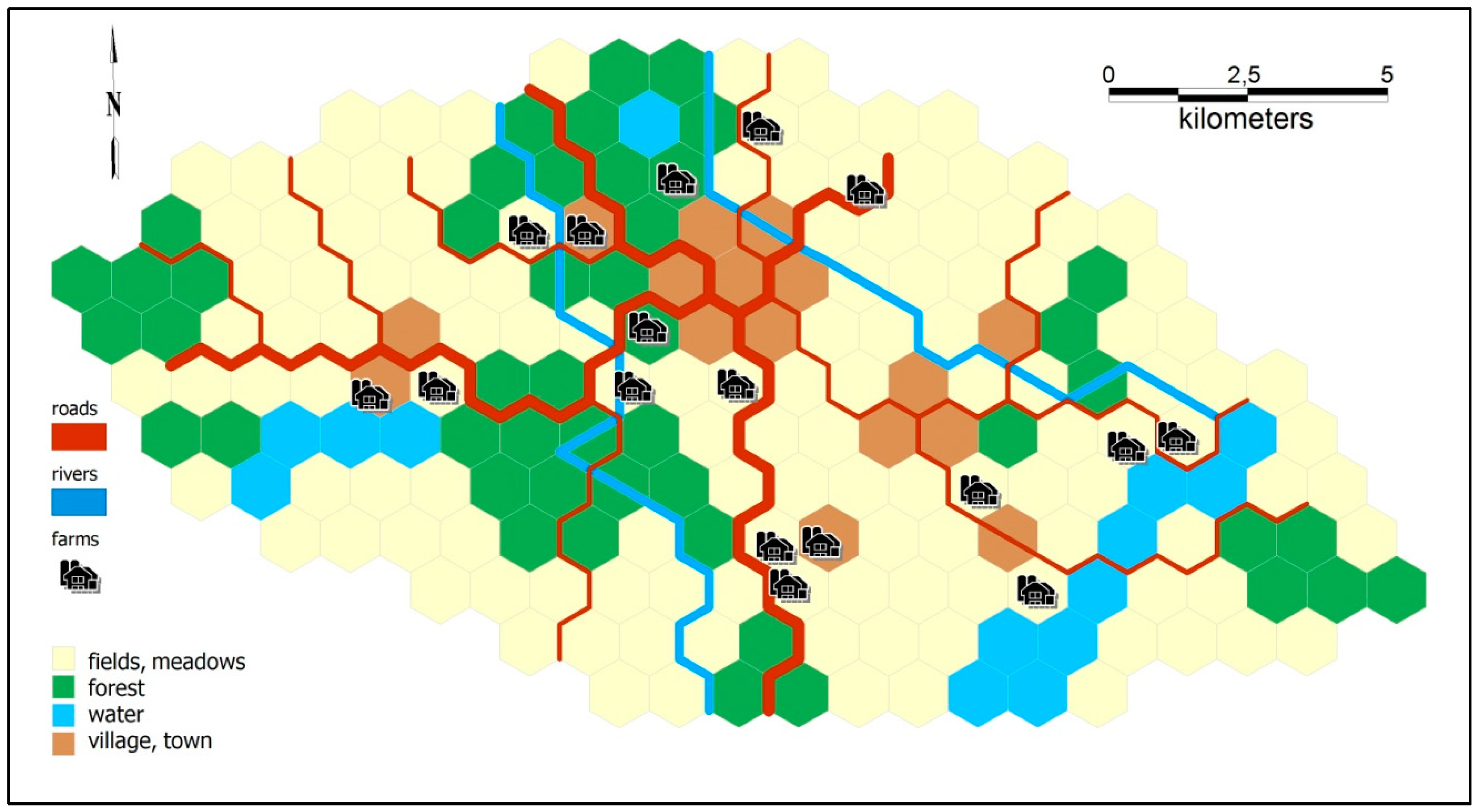
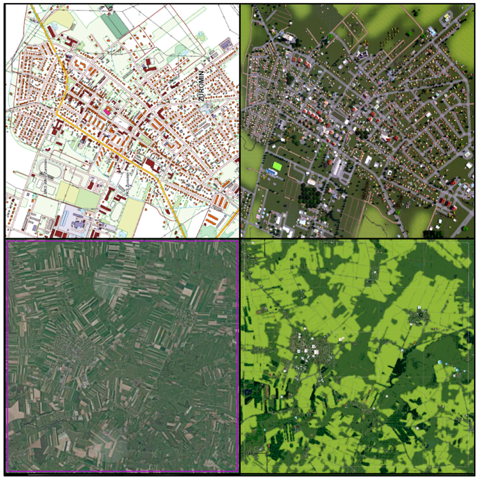
Cities: Skylines game engine (as described later in the article), but also proposing general rules of the game taking into account spatial aspects. For this purpose, topographic data were generalized and a map of Żuromin commune was developed in the form of a set of hexagons (
Figure 1). The tests carried out with the participation of residents and commune authorities on such a game board made it possible to conclude that creating a digital serious game makes sense because it significantly affects the behaviour of residents, authorities, and agricultural producers, and supports the process of mutual cooperation.
The game under development aims at activating the citizens to initiate, organise, and coordinate activities on their own, as well as to prompt them to engage in projects managed by the local authorities. It may streamline the decision-making process; improve the quality of life and increase satisfaction; and, particularly crucially, resolve any existing conflicts. In our tests, we use the concept of the humanistic coefficient, introduced by Florian Znaniecki, to examine, among others, cultural facts [
35,
36] (pp. 33–44). The humanistic coefficient says that the data of culture belong to the active experiences of people and are such as these active experiences make them. This approach allows for the creation of an open civil society [
37,
38,
39] using available geoinformation technologies.
The game was deliberately balanced in such a way that no two groups can outvote the third. Players can act on their own to some degree, but major improvements to their position are only available after a successful vote. All test groups that played for more than four turns were able to identify this dynamic, as evidenced by direct remarks made by players such as residents saying “we have to team up with officials” or farmers saying “you officials should side with us rather than with residents”.
The investments available in the game range from very cheap (less than one turn’s worth of official’s effort) to very expensive (virtually impossible to complete by the end of game, unless other improvements are made first or players agree to cooperate). In one special case, a biogas plant can be built and it was deliberately designed to be a superior solution in terms of in-game results. It solves the pollution problem immediately, giving the residents a boost to standard of living, and also offers minor additional income to entrepreneurs. It is, however, the most expensive project in the game, in terms of both funds and authorities’ effort. We introduced this option in order to verify if players can identify it as the superior solution, and then act to implement it.
Purely-cooperative entertainment games, such as the board game “Pandemic”, are prone to spontaneous leadership issues; one player takes charge over the others, who limit themselves to doing what they are told. At this point, the game essentially degrades to a single-player game. For that reason, we chose a ruleset that is not purely cooperative, but instead promotes cooperative thinking in terms of in-game benefits. We treat cooperation as a skill rather than a political stance.
4. An Authorial Mod of Cities: Skylines and Importing Data into the Game Engine
According to the authors (and based on the results of research and tests of the game conducted on an analogue board with hexagonal division), developing and popularising a serious game and running a social campaign to show that building a biogas plant would be beneficial for all the parties may not only be an extremely innovative, but also an effective means of solving this problem.
The project aims to develop solutions that will enable residents—regardless of age, health, education, digital technology competence, and the like—to co-decide on the town’s operation, influence the vision for its development, and monitor the state of the environment. The following comprise the implementation of the project:
Developing and online sharing of a spatial information system with an integrated system of odour sensors that enables the environmental monitoring and real-time determination of the impact of farms on the health and well-being of residents;
Developing and implementing of an online spatial information system and a geoportal that enables the analysis of environmental data, and supports the process of environmental impact assessment, as well as the visualisation of the air quality available to the town’s authorities and residents;
Developing a serious game that enables modelling changes in the environment that stem from the construction of a biogas plant, analysing the social relations in the town’s authorities–residents–livestock producers’ triangle, and an increase of the mutual trust of all the participants in the process.
The development of a digital twin of Żuromin required using official digital topographic data (corresponding to a map at 1:10,000 scale), digital models of LoD2 buildings according to the CityGML specification, a digital orthophoto map, and a numerical model of terrain with 50 cm resolution, as well as detailed demographic data on the inhabitants’ place of residence and work. A custom C# script was created to import the spatial data to the game engine; available sets of libraries developed, for example, in Python were also used. For all the imported objects—residential buildings, offices, production farms, and the like—photorealistic textures were used based on their real counterparts.
The authorial modification and import of topographic data (both vector and raster) into the game engine of Cities: Skylines used the game in versions from 1.11.1 to 1.12.1; the last version was also used for a functional check of the mod introduced later. Besides the basic version of the game, the first two “big” expansions were utilised, namely After Dark and Snowfall, as well as several mods created by the gaming community. The authors used C# to write the modification of the game (about 85,000 lines of code in total). The C# language was designed for Microsoft by a team led by Anders Hejlsberg and made available in 2000 as part of the company’s .NET initiative. It is a high-level, object-oriented, general-purpose language; its current version is 8.0.
The project used the official Polish Topographic Objects Database, BDOT10k (Baza Danych Obiektów Topograficznych), a database with an accuracy corresponding to an analogue map at 1:10,000, and a digital terrain model developed through laser scanning with a resolution of 1 m. The BDOT10k source data come from a central geodetic and cartographic resource and include the area of the Żuromin poviat. The data were made available in GML format in .xml files. The data in BDOT10k and DTM (digital terrain model) are up to 2015.
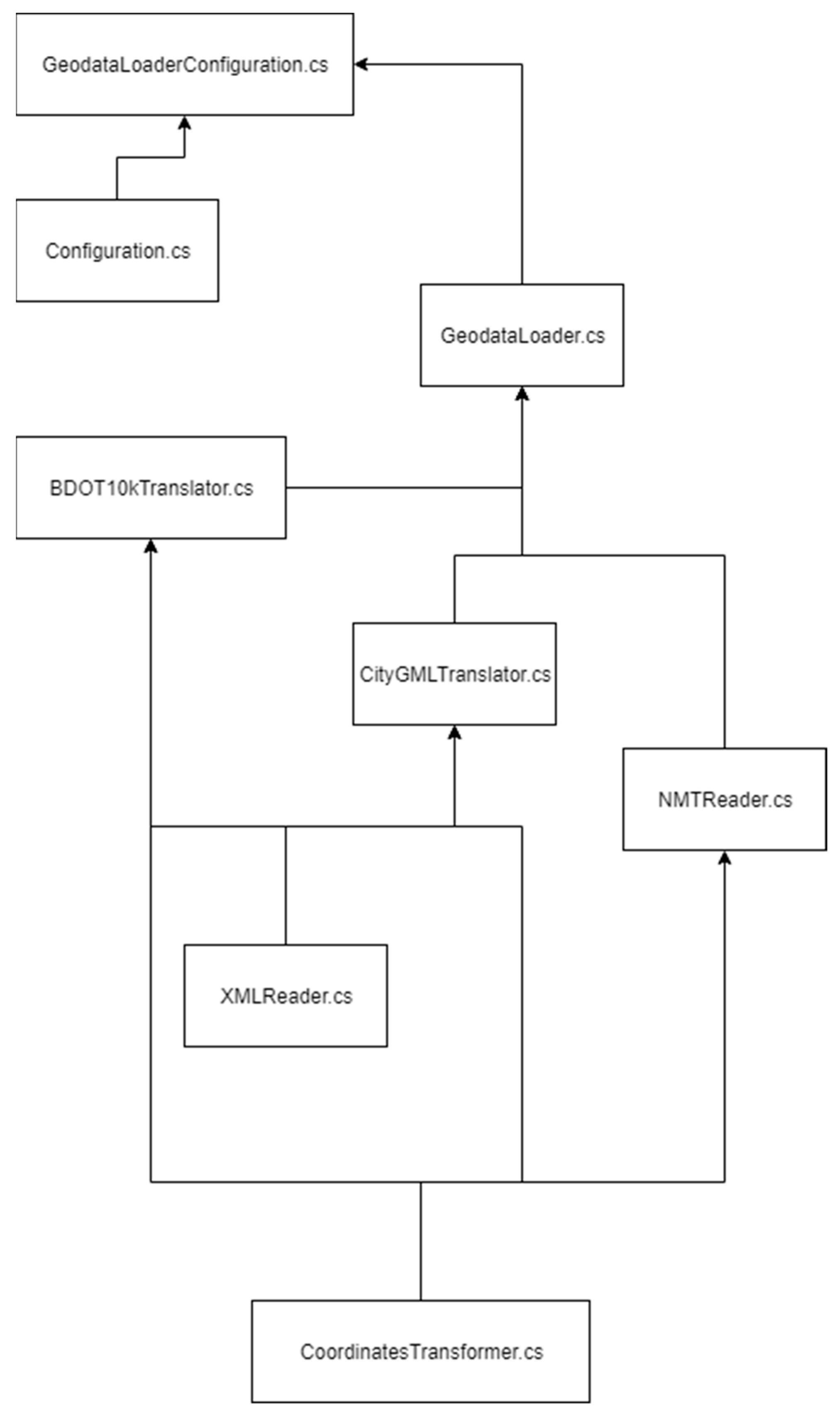
The research work included a general scheme of the process of converting source data into the game engine. It required the development of an entire series of classes written in C# contained within one library. As one of the fundamental assumptions was importing a complete set of spatial data, that is, BDOT10k, DTM, or CityGML, into the game engine of
Cities: Skylines, it was necessary to prepare a working diagram of the mod (
Figure 2).
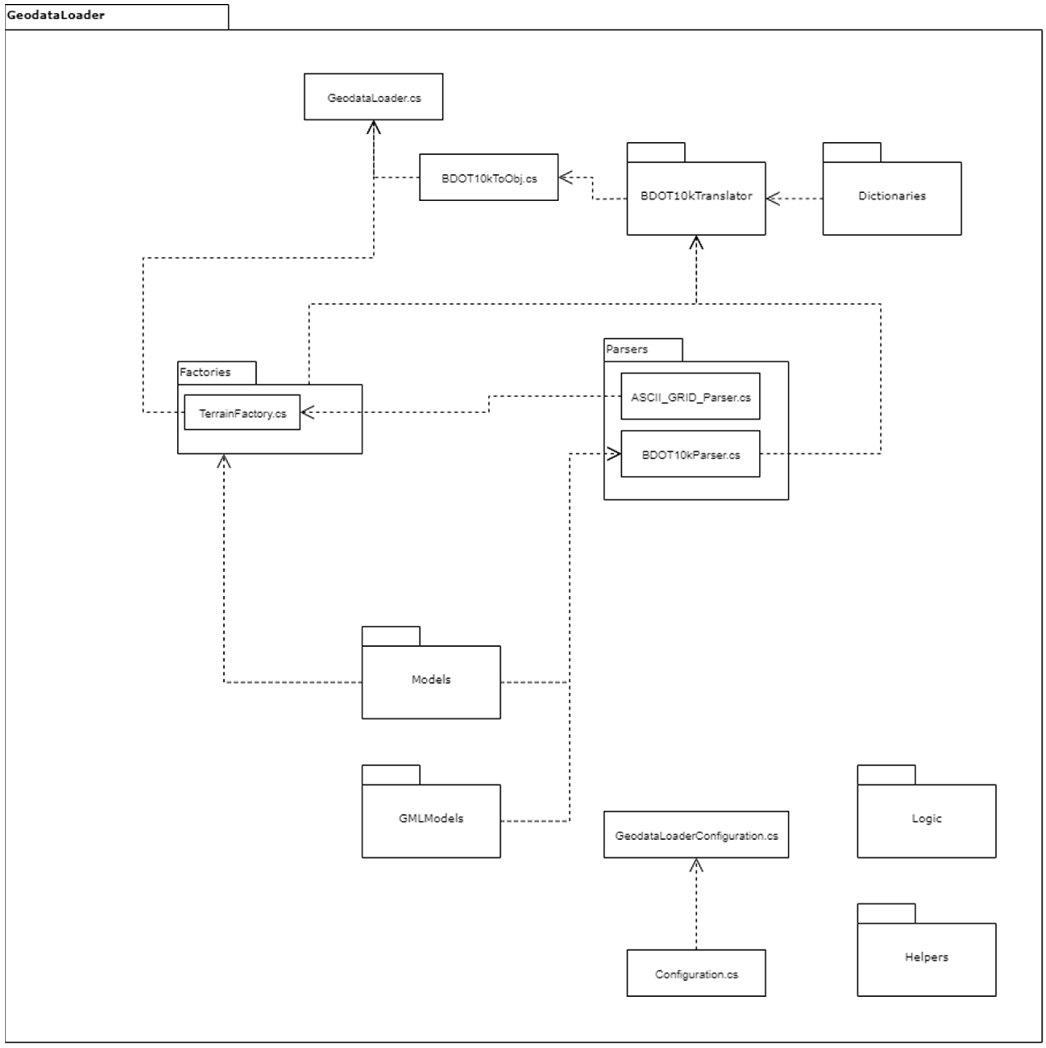
What was of crucial importance for the development of a tool that imports official spatial data into the game engine of Cities: Skylines was creating a syntax analyser (a parser). The schema of a single-object class was supplemented with all the necessary XML Schema (GML) files, namely schemas of 74 basic BDOT10k classes. They were adapted to the needs of each class by adding additional parse elements when necessary. As a result, the following class folders were created: GMLModels, containing .xml (GML) class models; Models, at first containing only models of parsed values; and Parsers, at first with only the BDOT10kParser.cs class-parser. Below is a snippet of the code.
![Ijgi 09 00118 i001]()
The process of importing BDOT10k structures into the environment of Cities: Skylines also required the development of a class that converts coordinates from PUWG 1992 (Państwowy Układ Współrzędnych Geodezyjnych 1992 coordinate system) into the game system, and checks whether given points are within the game area. The Coordinates.cs class was created to this end; it contains standard dimensions of the border of the game area (+/– 8640 meters) and also calculates and checks the coordinates with the midpoint of the area in the settings.
Using the parser for BDOT10k and the method of converting coordinates into a system, a set of Factories was developed, based on the source code for the Terrain Generator, Cimtographer, and Rainfall mods. Developing each of these mods required a different approach. The project incorporated seven such generators, each one responsible for a separate component of the game:
BuildingFactory.cs (all kinds of buildings);
NetFactory.cs (network objects, for example, roads, power lines);
PropFactory.cs (small objects represented solely with texture, for example, signs, bins, flowerbeds);
ResourceFactory.cs (raw materials that change the texture of the soil, for example, fertile soil, oil, ore);
TerrainFactory.cs (terrain generator);
TreeFactory.cs (generator of trees and plants);
WaterFactory.cs (generator of water sources and drains).
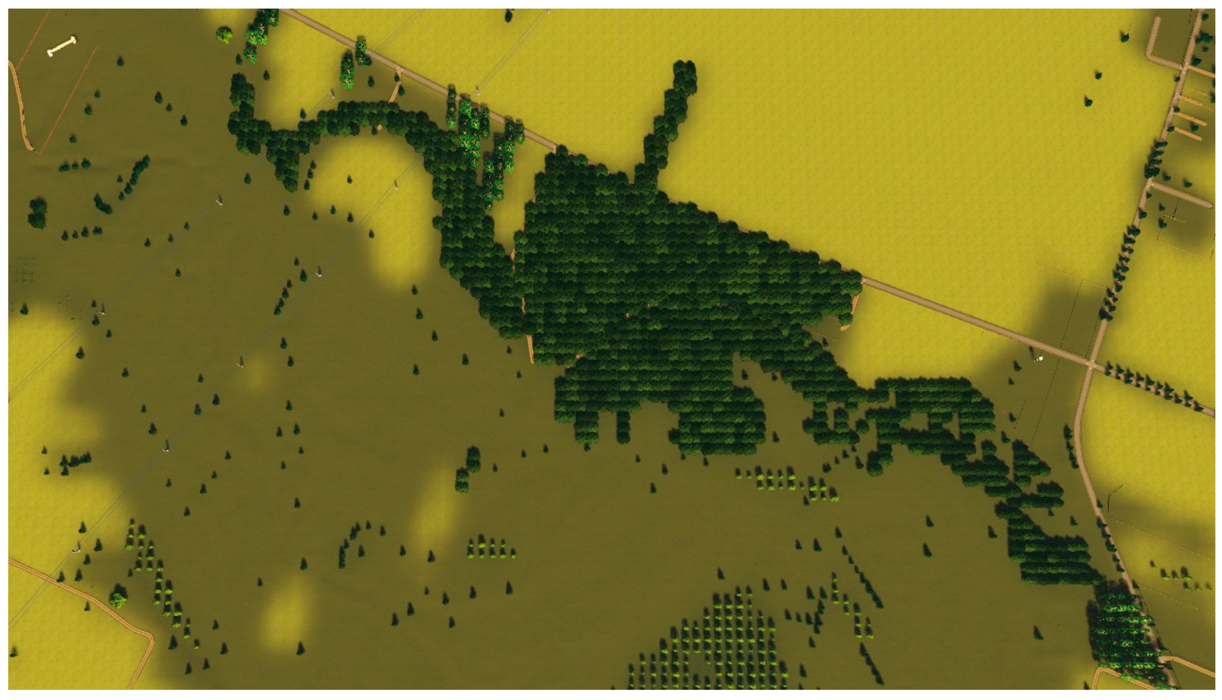
Many real-world structures modelled in BDOT10k and
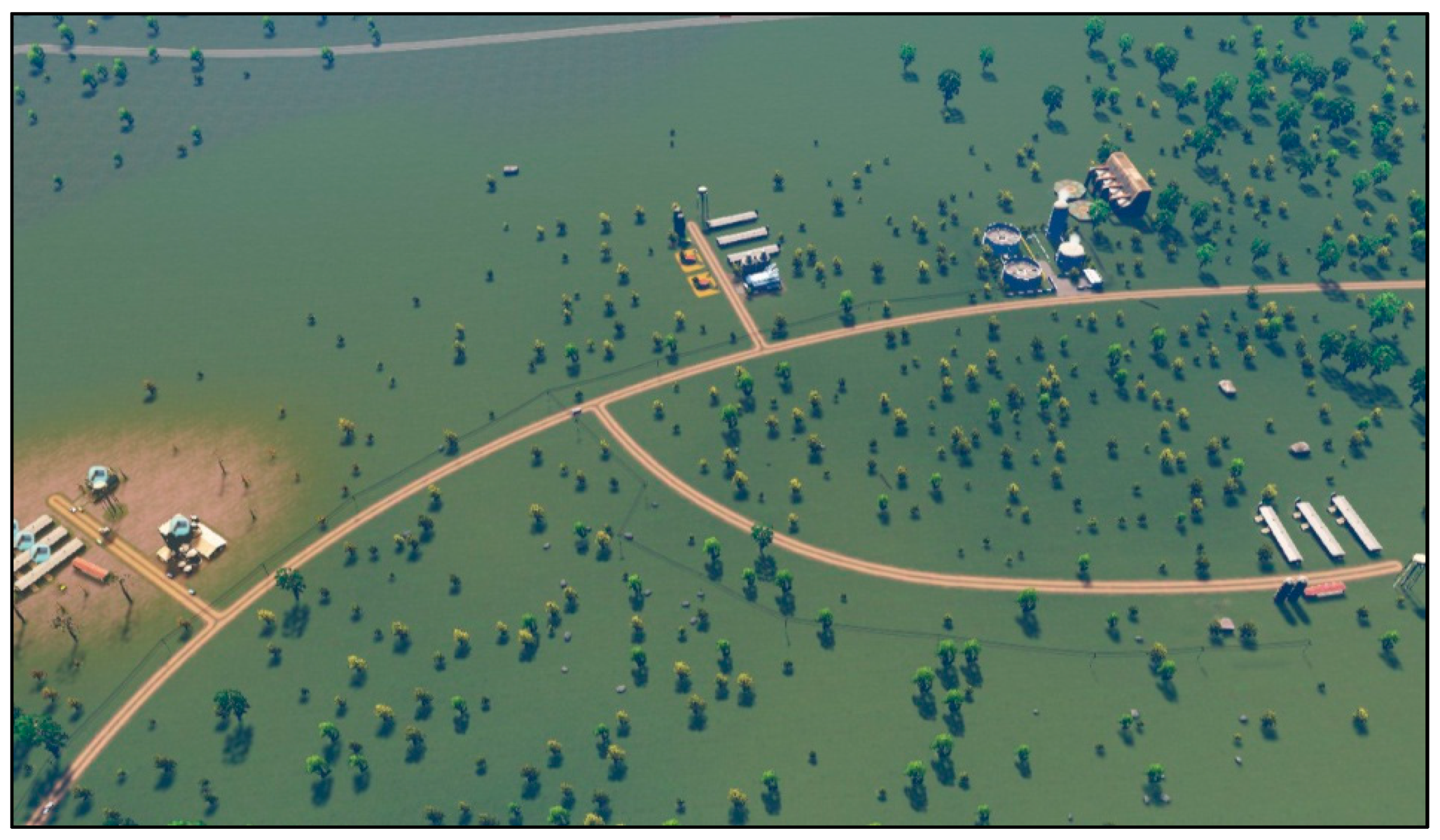
Cities: Skylines require appropriate repainting of the attributes. Also, these objects are often not positioned in the same way in both environments. For example, the centre of mass/insertion point on the ground and the angle of rotation of the model relative to the standard insertion direction, that is, the south, designate a building in the game. This required the development of several modifications implementing the rotation of particular objects; simplification of overly-complicated lines implemented through the Ramer–Douglas–Peucker algorithm; filling polygons, for example, covering the terrain with a forest (
Figure 3); and the development of multi-level dictionaries. However, thanks to the devised tools, a fully automated import of topographic BDOT10k data for any part of Poland into the game engine of
Cities: Skylines is possible.
Creating code in C# that enabled importing any set of source files containing digital terrain models involved a parallel approach. The methodology described in this article allows for a full integration of vector topographic and DEM (digital elevation model) imports in one process (
Figure 4). Generating the terrain model also required appropriate tiling of individual sections, similar to the one carried out in
GIS tools (
Figure 5).
The developed mod meets the adopted assumptions. It enables a quick and straightforward import of spatial data (both topographic vector objects and raster files describing the digital terrain model) into the gaming environment, while maintaining the accuracy of the topographic source data (
Figure 6).
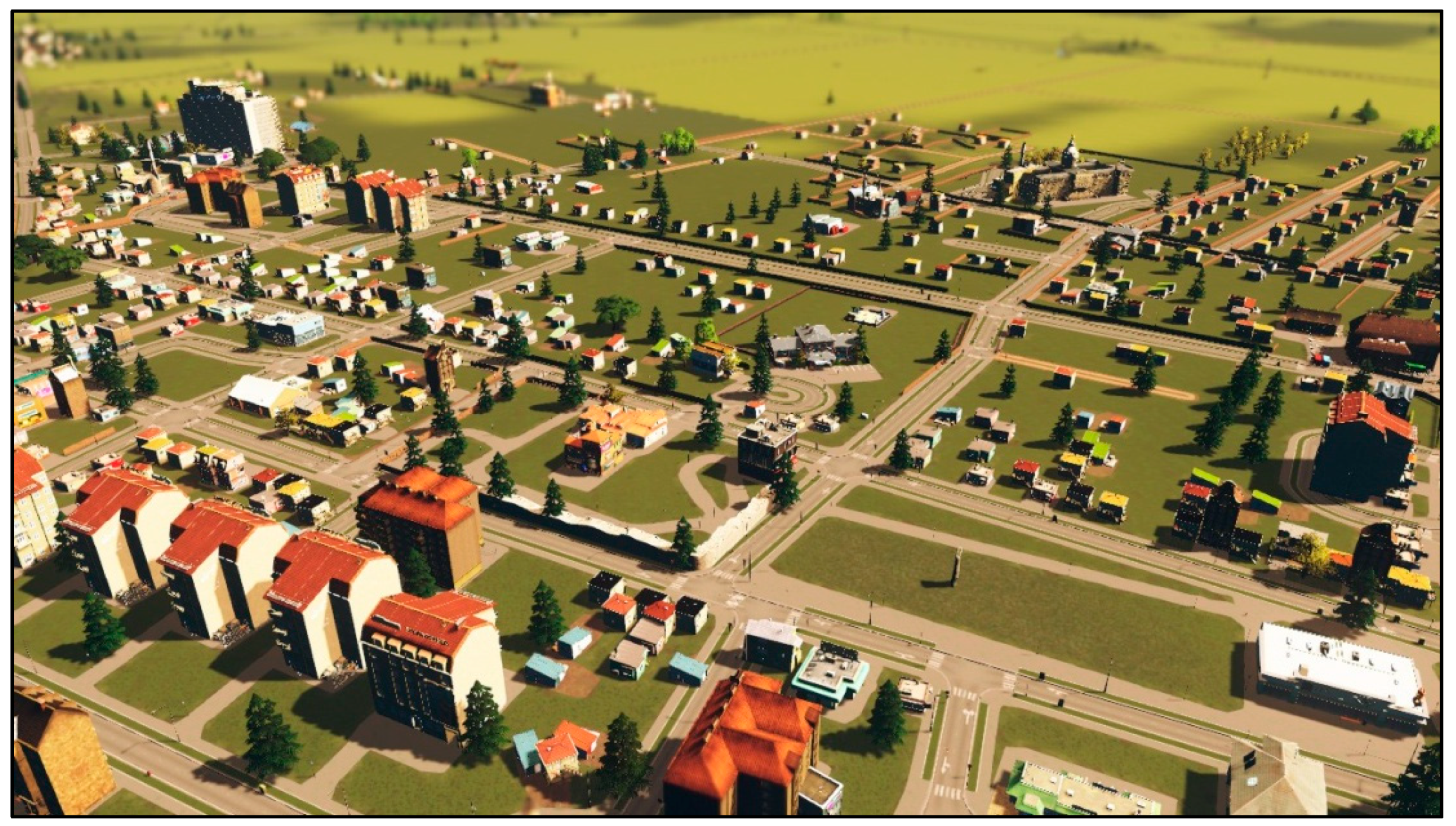
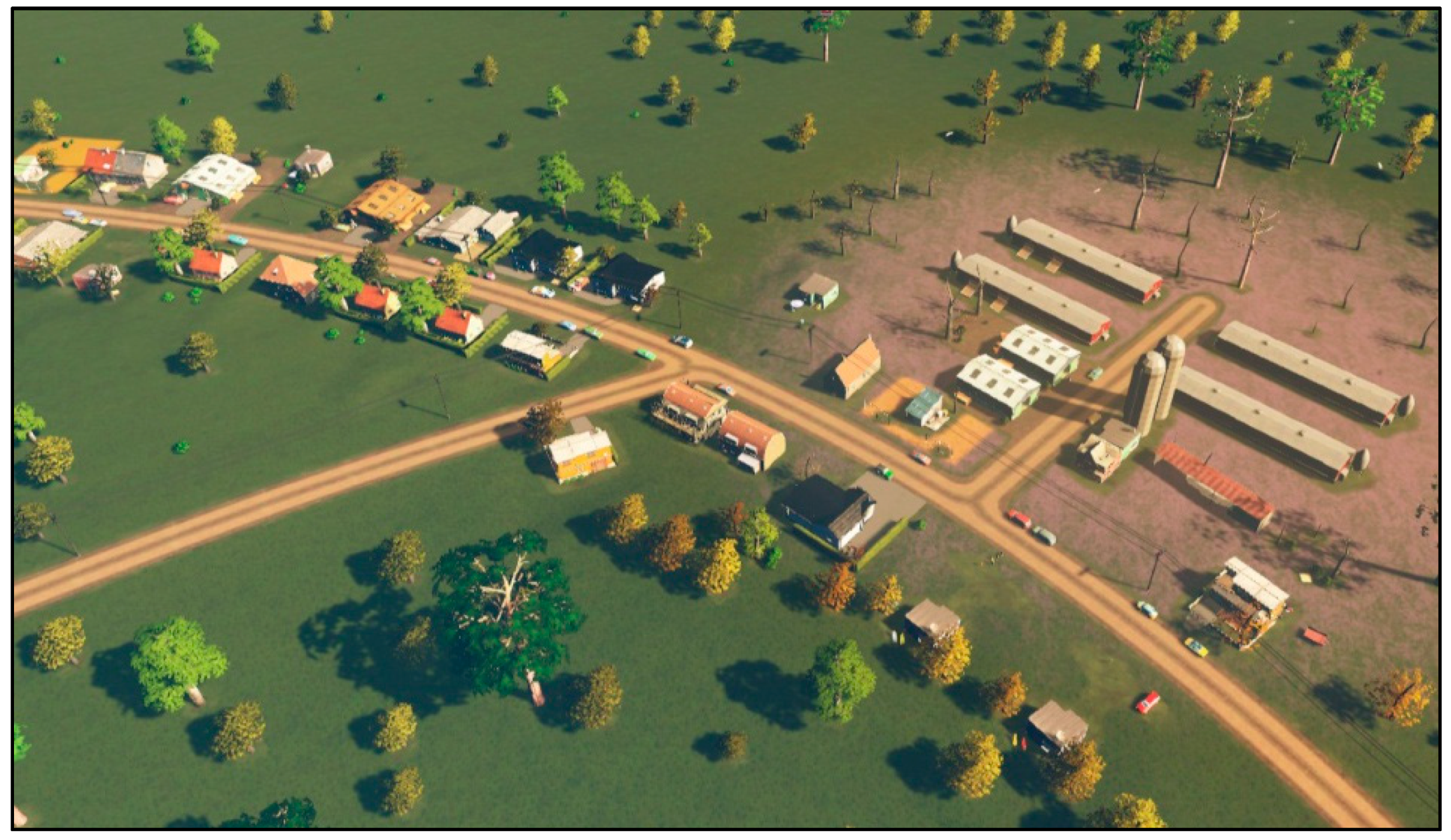
Figure 7 shows the mapping of farms and the neighbouring agricultural areas (vital for the test area of the Żuromin commune) in the game environment. The mod enables a fully automated data import for the urban area as well. However, one should note that a limited number of models of buildings for the basic version of the game without additional mods is becoming more visible, for example, as the duplication of models of buildings (
Figure 8).
The development of the source code in C# (about 85,000 lines of code) was the outcome of the work, enabling the automation of the process of the following:
selecting the appropriate object classes and attributes of the objects of the BDOT10k database (saved in the source .xml format) and importing them into the game environment of Cities: Skylines;
integrating of Digital Terrain Model sheets saved in the .asc source format and their import into the game environment of Cities: Skylines;
simplifying the lines where the geometry was too complicated;
rotating objects in relation to the route of the nearest road;
texturing surface structures;
replacing surface structures, linear, or point objects with their equivalents of different geometry;
searching the area and appropriate data;
coordinate conversion to the game system;
modelling of the impact of building a farm on environmental degradation in its vicinity (
Figure 9).
This mod may serve as a basis for developing a certain logic for simulations meant for real cities, or even entire regions, as well as specific simulations. In Żuromin, such a simulation deals with environmental pollution caused by farms and the opportunity to resolve this problem by creating a biogas plant in the area.
5. Discussion
The methodology proposed in the article and the developed IT tools enable fully automatic import of topographic and DEM data into the
Cities: Skylines game engine (
Table 1). It is interesting to compare the methodology described in this article with the approach proposed in the work of [
34].
Having the author’s own modification of the game engine enabling the import of any set of topographic data from the area of Poland and a set of rules described in the "Problem definition" section, it was also necessary to introduce a modification to Cities: Skylines to enable the construction of a biogas plant. The promotion of this solution is one of the main goals of the author’s serious game, supporting the process of solving social and ecological problems in the Żuromin municipality.
Testing the drawn up game rules resulted in developing a modification of the
Cities: Skylines’s engine—an implementation of rules related to the impact of the biogas on nearby farms, fields, and buildings [
40] (
Figure 10).
Given that all players have clearly defined and one-dimensional goals, it is feasible to provide one or more decision algorithms for each role and evolve the game into a basic multi-agent system. The main expected benefit is that it would be much easier to explore the players’ behaviour at a scale. Also, it would be possible to match, in a controlled manner, human players against agents acting in a predefined manner. It would produce quantitative insight into a player’s behaviour and help find the optimal environment for exploring real-world issues.
Research works were conducted in two ways: besides creating a tool for importing topographic data into Cities: Skylines for any area of Poland, the authors also developed and tested the rules of participatory games for a specific municipality. This particular serious game means to convince users (residents, municipal authorities, and livestock producers) that building a biogas plant is a win–win solution. Natural fertilizers must be distributed in such a way that the dose of nitrogen introduced in them does not exceed 170 kg N per 1 ha. Knowing the nitrogen content of liquid manure, we should determine the permissible dose of fertilizer that can be used. This does not mean that maximum doses are recommended, unless necessary. If the land resources on the farm are large enough, it is more advisable to use smaller doses on a larger area of arable land, that is, cover all fields as evenly as possible.
If the production of fertilizers is too high in relation to the arable land area, then other ways of managing the surplus fertilizer should be considered (for example, contract for transfer to a biogas plant or for agricultural use by another farm). Meanwhile, there is no biogas plant in the commune, which would both help partially solve the problem of odor nuisance, and allow the city, residents, and enterprises (depending on who would own the biogas plant) to use electricity and heat.
Currently, the main question remains of whether players are making decisions based on their concepts of what is right or wrong for them, or whether they follow what they perceive as the best possible path to an in-game victory. In other words, do they discard their real-life role and enter the Magic Circle fully, or do they apply real-world experience to the in-game environment?
6. Summary and Future Works
The aim of the developed concept of a serious game is to show the benefits of the cooperation of a smart city’s residents with its authorities and the local business and to visualise the beneficial environmental changes related to the construction of a biogas plant.
The developed ruleset can be applied to a broad set of urban planning issues. It is possible to balance fidelity of the simulation against its accessibility. In other words, we could create either a slow, but detailed simulation that gives players a more technical insight, or a less involved, but much more accessible presentation that provides players with basic intuition on a given issue. In our test case, we trained players to find a solution that is already determined as superior. However, it is possible to design a similar game that trains players to make informed decisions on whether or not a given solution is preferable.
In other words, applicability of our serious game is not limited to small towns such as Żuromin, or specialized issues such as air and soil pollution from industrial farming. If the application aims at helping users empathise with the point of view of the city’s authorities, a single-player game with a multi-agent system would be preferred; providing support for public consultations conducted by the city’s authorities requires the implementation of the networked version of the game.
The results from the experiment on the game prototype indicate a vital role of ethical issues, both in the process of social participation and the use of serious games in social education, spatial planning, and shaping the vision for a city’s development. Social participation in spatial planning and the—broadly understood—co-creation of the vision for its development constitute crucial elements of the process of creating a resident-friendly environment.
One the one hand, conducting the research works in two ways made it possible to develop a prepared, three-dimensional model of the real world comprising the entire commune and its implementation into the game engine of Cities: Skylines. On the other hand, functional testing and testing the rationale behind the rules of the game carried out on the analogue version, which uses a hex map, enabled testing of the game mechanics, its social perception, and the educational value of a serious game. As a result, these two solutions will unify shortly; namely, there will be a full implementation of the game rules into the environment of Cities: Skylines, on a prepared and functional topographic model, created based on detailed reference data.
Both theory and practice provide numerous arguments in favour of the opinion that the exchange of experience between in-game worlds and real-life worlds is intense. However, most of these examples consider fictional or fantasy scenarios in an environment focused solely on entertainment. As authors of a serious game with a specific desired application, we need to ask whether the experience exchange is relevant to the real-world issue that is being explored. Metaphorically speaking, there are thousands of books and films that convince humans that wars are disastrous, but people who consume them still wage wars. We aim to explore the potential of serious games to offer advantages as decision-making tools and vehicles for conscious social change [
41,
42].


