Study on the Level and Type Identification of Rural Development in Wuhan City’s New Urban Districts

Abstract
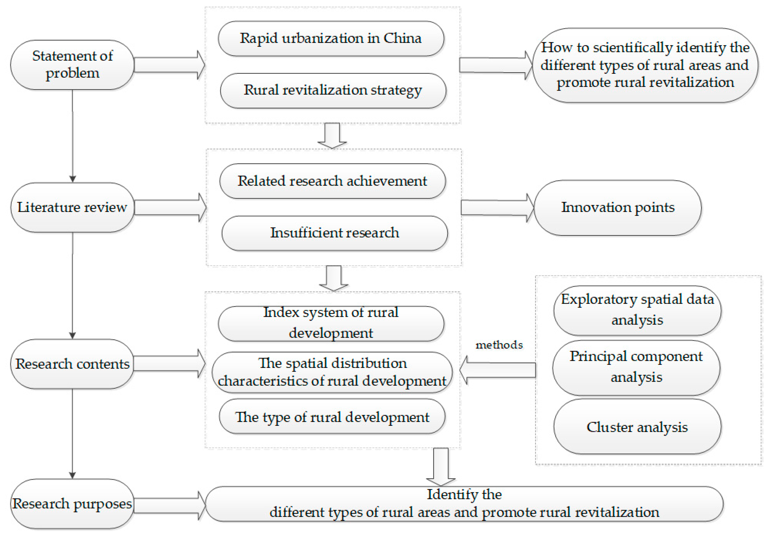
:1. Introduction
2. Materials and Methods
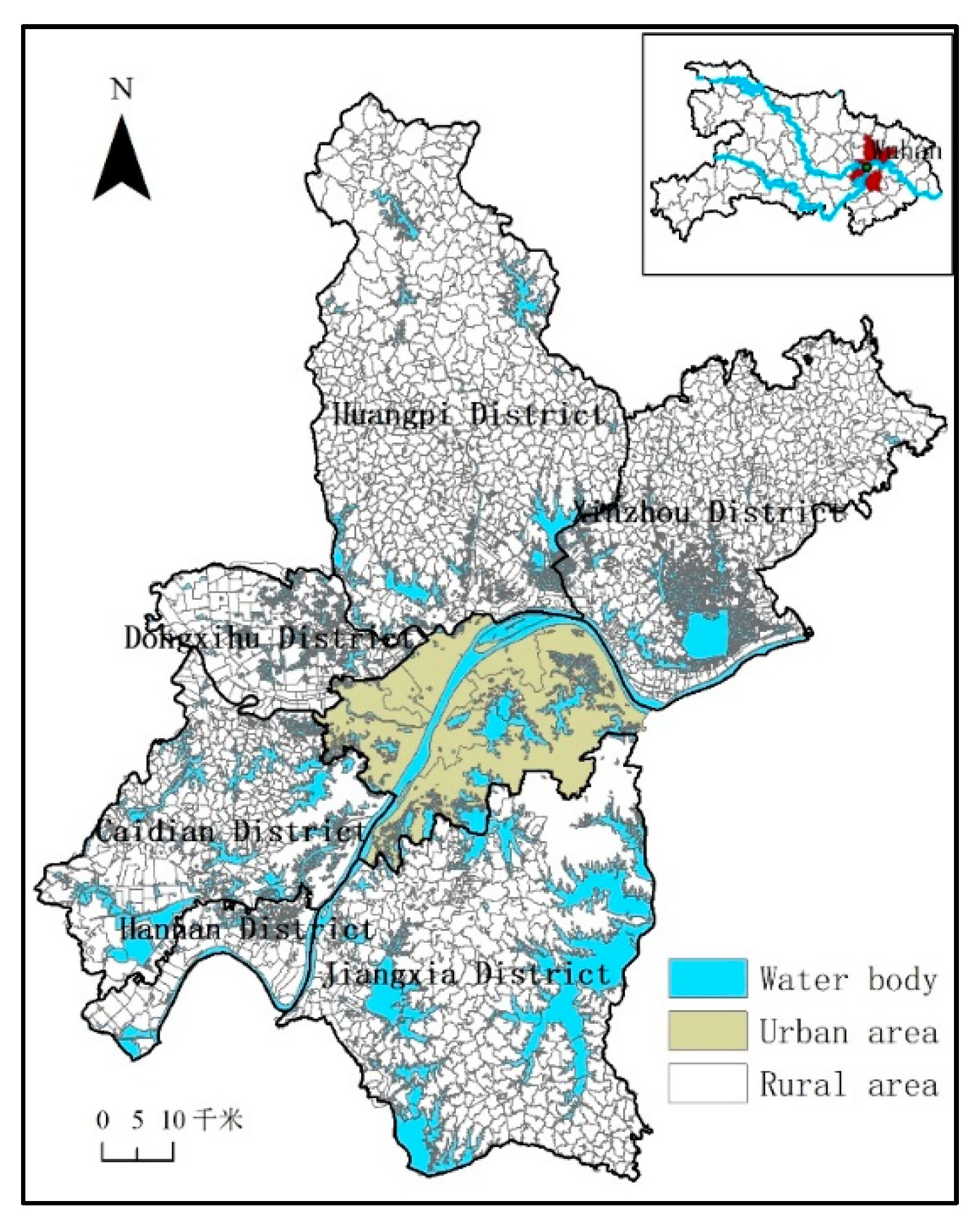
2.1. Research Area
2.2. Data Source
2.2.1. Data on the Administrative Village in Wuhan
2.2.2. Data on Basic Geographic Conditions in Wuhan
2.2.3. Data on Social and Economic Development
2.3. Research Methods
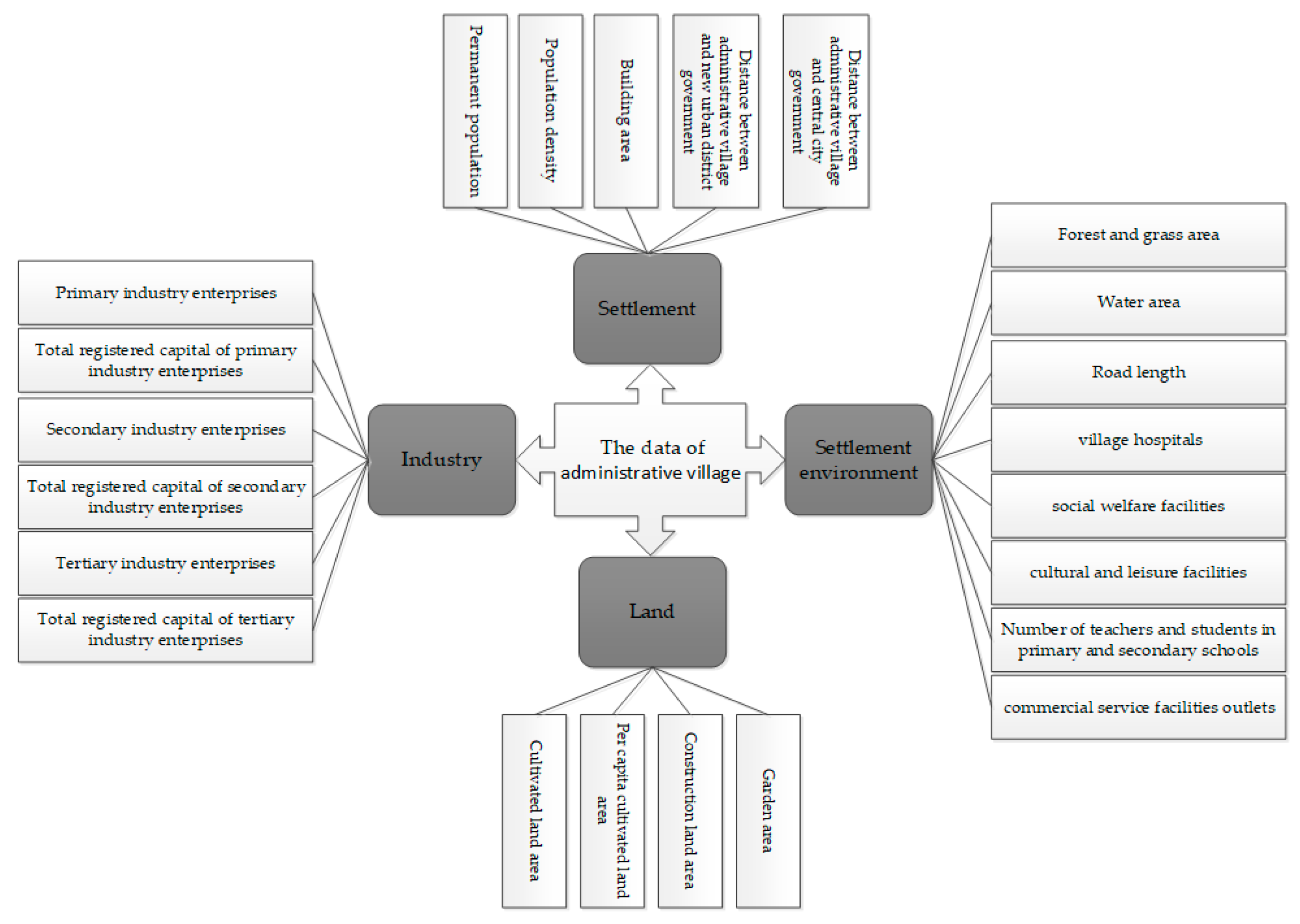
2.3.1. Construction of the Evaluation Index System
2.3.2. Data Standardization and Weight Determination
2.3.3. Exploratory Spatial Data Analysis (ESDA)
2.3.4. Cluster Analysis
3. Results
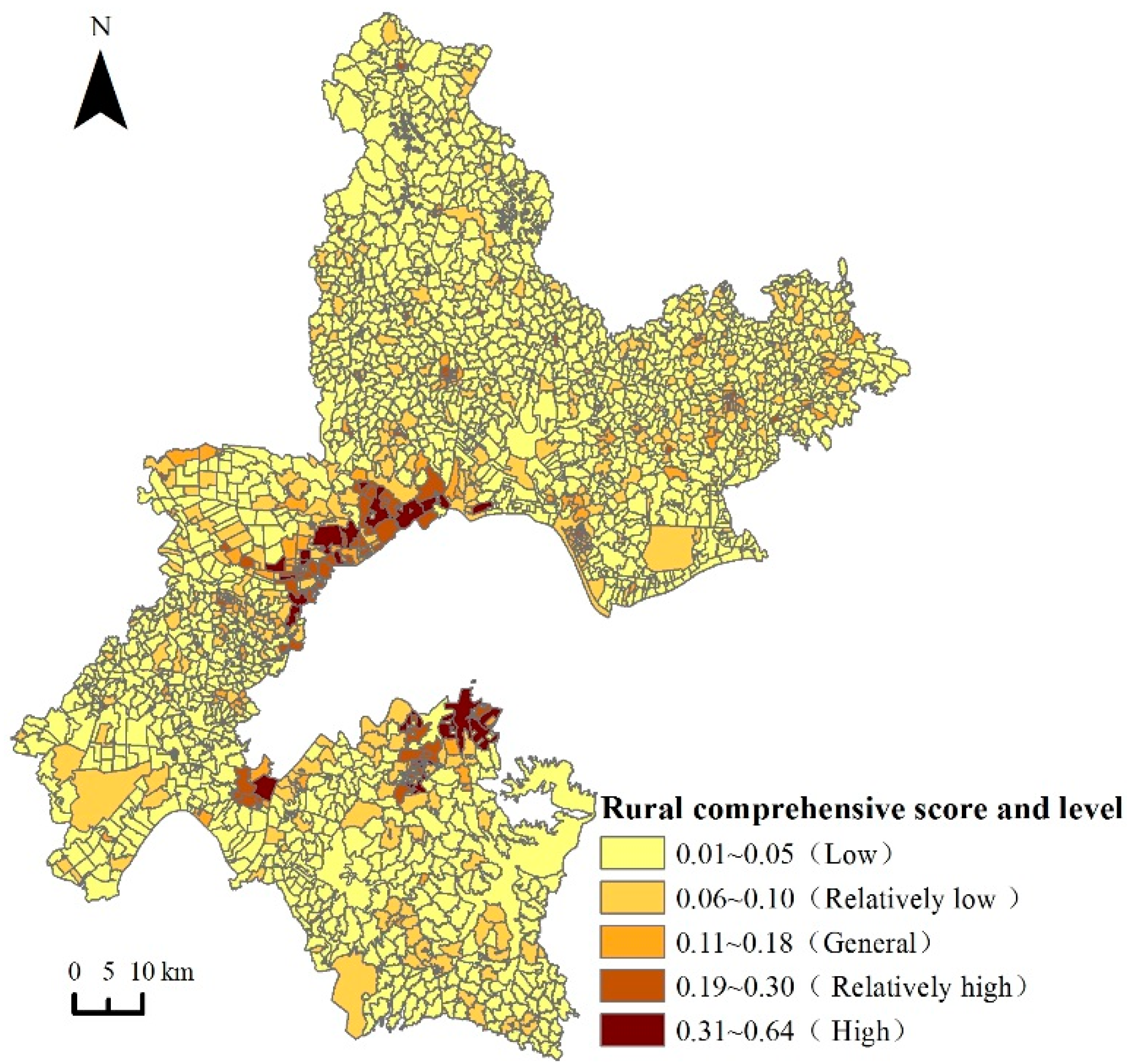
3.1. Spatial Pattern of the Rural Development Level
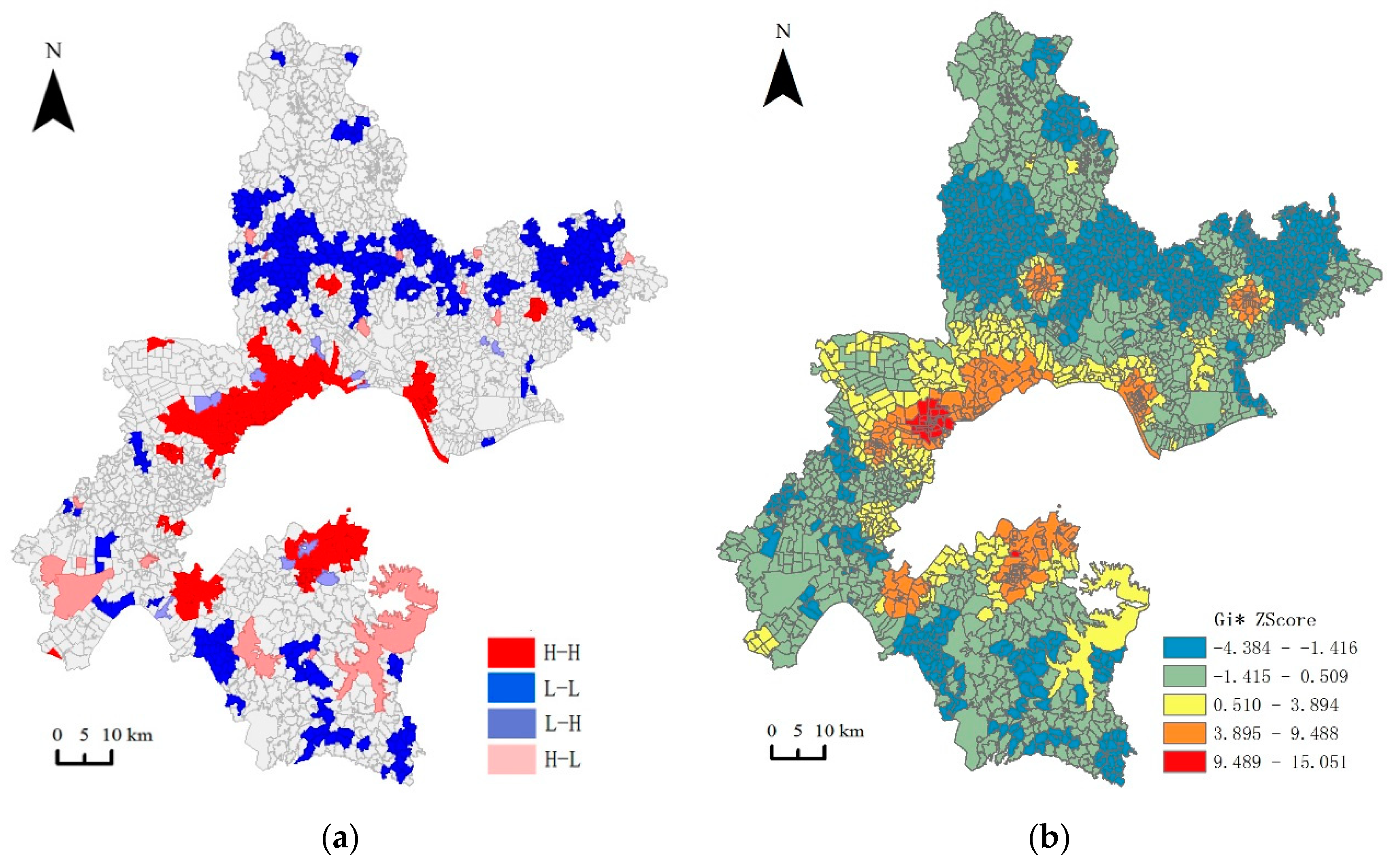
3.2. Spatial Connection of the Rural Development Level
3.2.1. Global Spatial Characteristics
3.2.2. Local Spatial and Hot Spot Characteristics
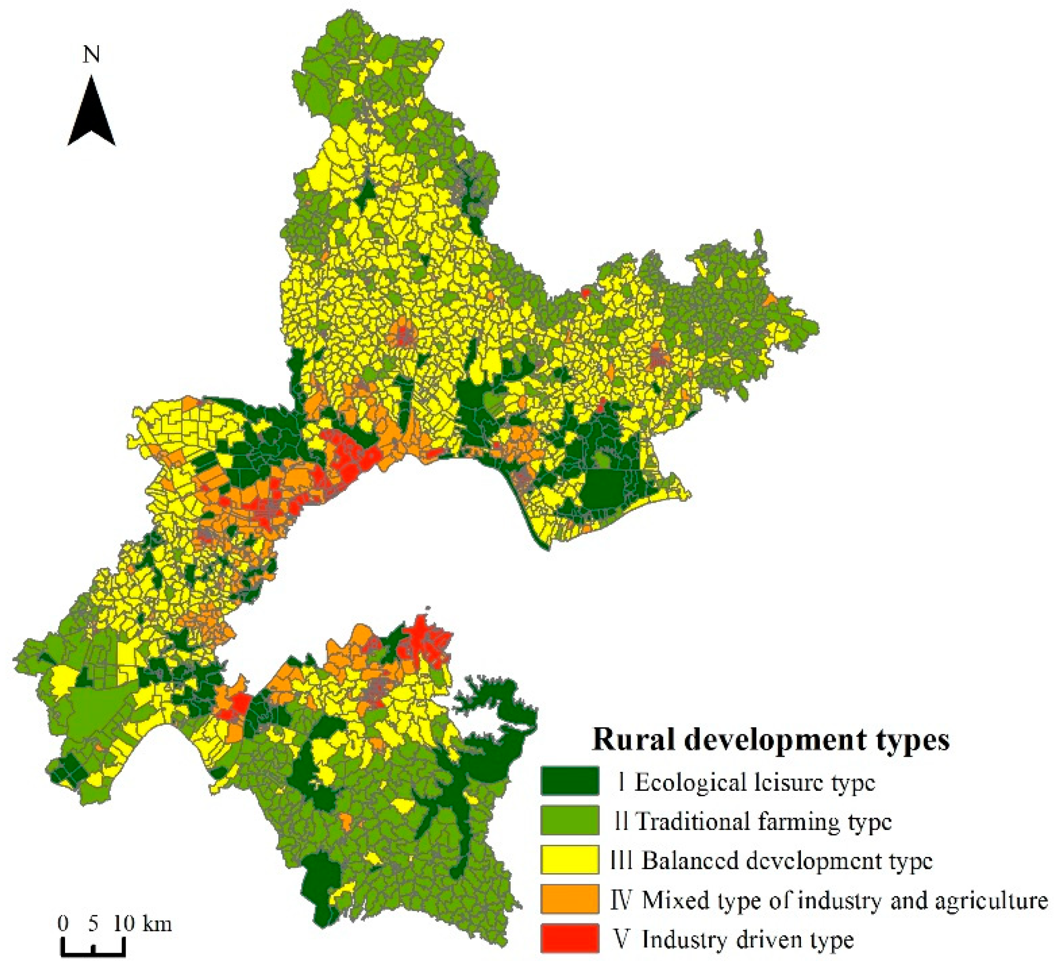
3.3. Type and Path of Rural Development
3.3.1. Principal Factor
3.3.2. Types of Rural Development
3.3.3. Rural Development Path
4. Discussion
4.1. Impact of Metropolitan Areas and Non-metropolitan Areas on the Surrounding Rural Development Is Quite Different
4.2. Spatial Characteristics of Rural Development Promote Top-Level System Design of Wuhan Government
4.3. Identification of the Rural Area Types Is the Basis of Orderly Classification to Promote China’s Rural Revitalization Strategy
4.4. Limitations of the Study
5. Conclusions
Author Contributions
Funding
Acknowledgments
Conflicts of Interest
References
- Liu, Y.S.; Zhang, Z.W.; Wang, J.Y. Regional differentiation and comprehensive regionalization scheme of modern agriculture in China. Acta Geogr. Sin. 2018, 73, 203–218. [Google Scholar] [CrossRef]
- Zhou, Y.; Guo, Y.Z.; Liu, Y.S. Areal types and their development paths in rural China. Geogr. Res. 2019, 38, 467–481. [Google Scholar] [CrossRef]
- Wang, X.; Wang, X.M.; Wu, J.X.; Zhao, G.C. Social network analysis of actors in rural development: A case study of yanhe v-illage, hubei province, china. Growth Chang. 2017, 48, 869–882. [Google Scholar] [CrossRef]
- The Food and Agriculture Organization (FAO). Food and Agriculture Data. 2018. Available online: http://www.fao.org/faostat/en/#home (accessed on 15 February 2020).
- Seto, K.; Fragkias, M. Quantifying spatiotemporal patterns of urban land-use change in four cities of China with time ser-ies landscape metrics. Landsc. Ecol. 2005, 20, 871–888. [Google Scholar] [CrossRef]
- Montgomery, M.R. The urban transformation of the developing world. Science 2008, 319, 761–764. [Google Scholar] [CrossRef] [PubMed] [Green Version]
- Yang, Y.Y.; Liu, Y.S.; Li, Y.R.; Li, J.T. Measure of urban-rural transformation in Beijing-Tianjin-Hebei region in the new mille-nnium:population-land-industry perspective. Land Use Policy 2018, 79, 595–608. [Google Scholar] [CrossRef]
- Capo, E. Transformation and development in Italian rural society. Sociol. Rural. 1995, 35, 297–308. [Google Scholar] [CrossRef]
- Cloke, P. An index of rurality for England and Wales. Reg. Stud. 1977, 11, 31–46. [Google Scholar] [CrossRef]
- Nelson, P.B. Rural restructuring in the American west: Land use, family and class discourses. J. Rural Stud. 2001, 17, 395–407. [Google Scholar] [CrossRef]
- Woods, M. Rural cosmopolitanism at the frontier? Chinese farmers and community relations in northern Queensland, 1890–1920. Aust. Geogr. 2018, 49, 107–131. [Google Scholar] [CrossRef] [Green Version]
- Liu, Y.S. Research on the urban-rural integration and rural revitalization in the new era in China. Acta Geogr. Sin. 2018, 73, 637–650. [Google Scholar] [CrossRef]
- Wei, W.; Zhang, Y.L.; Zhao, B.; Wang, H. Impacts of urban expansion on spatio-temporal variation of landscape patterns duri-ng rapid urbanization: A case study of Kunshan City. Ecol. Environ. Sci. 2011, 20, 7–12. [Google Scholar] [CrossRef]
- Ma, X.D.; Li, Q.L.; Shen, Y. Morphological difference and regional types of rural settlements in Jiangsu Province. Acta Geogr. Sin. 2012, 67, 516–525. [Google Scholar] [CrossRef]
- Feng, J.; Liu, Y. Restructuring the rural landscape and spatial planning of towns in Jiangsu Province. Resour. Sci. 2008, 30, 737–743. [Google Scholar] [CrossRef]
- Zhou, Y.; Li, Y.M.; Xu, C.C. Land consolidation and rural revitalization in China: Mechanisms and paths. Land Use Policy 2020, 91. [Google Scholar] [CrossRef]
- Chen, K.Q.; Long, H.L.; Liao, L.W.; Tu, S.S.; Li, T.T. Land use transitions and urban-rural integrated development: Theoretical fra-mework and China’s evidence. Land Use Policy 2020, 92. [Google Scholar] [CrossRef]
- Xi, J.P. Winning a Comprehensively Completed Well-Off Society and Seizing the Great Victory of Socialism with Chinese Characteristics in the New Era—Report at the 19th National Congress of the Communist Party of China; People’s Publishing House: Beijing, China, 2017. [Google Scholar]
- Thu, N.T.A. One village one product(OVOP) in Japan to one tambon one product(OTOP) in Thailland: Lessons for grass root development in developing countries. J. Soc. Dev. Sci. 2013, 4, 529–537. [Google Scholar] [CrossRef]
- Hasan, E.U. Nature-based tourism and revitalization of rural communities in Japan: An ethnographic case study of Oya-ma Town. J. Soc. Sci. Stud. 2017, 4, 140–159. [Google Scholar] [CrossRef]
- Samuel, P.S.H. Economic development and rural industry in South Korea and Taiwan. World Dev. 1982, 10, 973–990. [Google Scholar] [CrossRef]
- Besley, T.; Burgess, R. Land refom, poverty reduction, and growth: Evidence from India. Q. J. Econ. 2000, 115, 389–430. [Google Scholar] [CrossRef]
- Cloke, P. Changing patterns of urbanisation in rural areas of England and Wales, 1961–1971. Reg. Stud. 1978, 12, 603–617. [Google Scholar] [CrossRef] [PubMed]
- Woods, M. Rural geography: Processes, responses and experiences in rural restructuring. J. Rural Stud. 2005, 21, 375–377. [Google Scholar] [CrossRef]
- Halfacree, K. Talking about rurality: Social representations of the rural as expressed by residents of six English parishes. J. Rural Stud. 1995, 11, 1–20. [Google Scholar] [CrossRef]
- Harrington, V.; Donoghue, D. Rurality in England and Wales 1991: A replication and extension of the 1981 rurality index. Sociol. Rural. 1998, 38, 178–203. [Google Scholar] [CrossRef]
- Duenckmann, F. The village in the mind: Applying Q-methodology to reconstructing constructions of rurality. J. Rural Stud. 2010, 26, 284–295. [Google Scholar] [CrossRef]
- Martin, P. Baroque rurality in an English village. J. Rural Stud. 2014, 33, 56–70. [Google Scholar] [CrossRef] [Green Version]
- Meng, H.H.; Li, T.S.; Yu, Z.S.; Li, F. Rurality and acorrelation analysis of the county economy in Anhui Province. Econ. Geogr. 2013, 33, 144–148. [Google Scholar] [CrossRef]
- Sun, Y.; Cheng, Y.Q.; Zhang, P.Y. Spatio-temporal dynamics of rurality in Northeast China. Geogr. Res. 2015, 34, 1864–1872. [Google Scholar] [CrossRef]
- LI, T.T.; Long, H.L. Study on the spatio-temporal pattern of rural transformation development in Shandong Province. Geogr. Res. 2014, 33, 490–500. [Google Scholar] [CrossRef]
- Yang, R.; Liu, Y.S.; Long, H.L.; Zhang, Y.J. Research progress and prospect of rural transformation and reconstruction in China: Paradigms and main content. Prog. Geogr. 2015, 34, 1019–1030. [Google Scholar] [CrossRef] [Green Version]
- Stola, W. The functional classification of rural areas in the mountain regions of Poland. Geogr. Pol. 1986, 52, 235–248. [Google Scholar]
- Yamamoto, S.; Tabayashi, A. The structure of rural spaces in Japan: The impact of urbanization and off-farm employment on the transforamation of Japan’s rural area. Sci. Rep. Inst. Geosci. Univ. Tsukuba 1989, 10, 1–21. [Google Scholar]
- Sharma, H.R. Distribution of landholdings in rural India, 1953–1954 to 1981–1982:implications for land reforms. Econ. Political Wkly. 1994, 29, 117–128. [Google Scholar] [CrossRef]
- Krause, G.; Glaser, M. Coevolving geomorphical and socioeconomic dynamics in a coastal fishing village of the Bragança region (Pará, North Brazil). Ocean Coast. Manag. 2003, 46, 859–874. [Google Scholar] [CrossRef]
- Hodge, I.; Monk, S. The economic diversity of rural England:stylised fallacies and uncertain evidence. J. Rural Stud. 2004, 20, 263–272. [Google Scholar] [CrossRef]
- Jerzy, B.; Marcin, M. Classification of rural areas in Poland as an instrument of territorial policy. Land Use Policy 2016, 54, 1–17. [Google Scholar] [CrossRef]
- Pramit, V.; Raghubanshi, A.S. Rural development and land use land cover change in a rapidly developing agrarian South Asian landscape. Remote Sens. Appl. Soc. Environ. 2019, 14, 138–147. [Google Scholar] [CrossRef]
- United States Department of Agriculture. Rural America at a Glance, 2016 Edtion. Available online: https://www.ers.usda.gov/publications/pub-details/?pubid=80893 (accessed on 4 January 2020).
- Berdguéa, J.A.; Soloagab, I. Small and medium cities and development of Mexican rural areas. World Dev. 2018, 107, 277–288. [Google Scholar] [CrossRef]
- Gehan, A.G.; Hamid, E.B.; Berjan, S. Governance of rural development in Egypt. Ann. Agric. Sci. 2014, 5, 285–296. [Google Scholar] [CrossRef] [Green Version]
- Pasmans, T.; Hebinck, P. Rural development and the role of game farming in the Eastern Cape, South Africa. Land Use Policy 2017, 64, 440–450. [Google Scholar] [CrossRef]
- Liu, Y.; Tang, T.N.; Pan, Y.C. Multifunctional characteristics and revitalization strategies of different types of rural develop-ment at village scale. Trans. Chin. Soc. Agric. Eng. 2019, 35, 9–17. [Google Scholar] [CrossRef]
- Wang, Y.F.; Liu, Y.S.; Li, Y.H. The spatial disparity of rural transition development and regional characteristics of its driving forces. Econ. Geogr. 2016, 36, 135–142. [Google Scholar] [CrossRef]
- Zhou, H.; Wang, B.J. Analysis of the coupling rurality index and rural transformation development of Jiangsu Province in China in the early 21st century. China Population. Resour. Environ. 2013, 23, 48–55. [Google Scholar] [CrossRef]
- Guo, Y.J.; Liu, Y.S.; Li, Y.R. Study on rural endogenous development driven by inner power. Econ. Geogr. 2012, 32, 114–119. [Google Scholar] [CrossRef]
- Takeuchi, K.; Namiki, Y.; Tanaka, H. Designing eco-villages for revitalizing Japanese rural areas. Ecol. Eng. 1998, 11, 177–197. [Google Scholar] [CrossRef]
- Fieldsend, A.F. Rural renaissance: An integral component of regional economic resilience. Stud. Agric. Econ. 2013, 115, 85–91. [Google Scholar] [CrossRef] [Green Version]
- Li, Y.; Liu, Y.; Long, H.; Cui, W. Community-based rural residential land consolidation and allocation can help to revitalize h-ollowed villages in traditional agricultural areas of China: Evidence from Dancheng County, Henan Province. Land Use Policy 2014, 39, 188–198. [Google Scholar] [CrossRef]
- Zhang, Y.N.; Long, H.L.; Ma, L.; Ge, D.Z.; Tu, S.S.; Qu, Y. Farmland function evolution in the Huang Huai Hai Plain: Processes, patterns and mechanisms. J. Geogr. Sci. 2018, 28, 759–777. [Google Scholar] [CrossRef] [Green Version]
- Liu, Y.S.; Lu, S.S.; Chen, Y.F. Spatio-temporal change of urban–rural equalized development patterns in China and its drivi-ng factors. J. Rural Stud. 2013, 32, 320–330. [Google Scholar] [CrossRef]
- Wu, C.J. The core of study of geography:Man-land relationship areal system. Econ. Geogr. 1991, 11, 1–6. [Google Scholar] [CrossRef]
- Long, H.L.; Tu, S.S. Theoretical thinking of rural restructuring. Prog. Geogr. 2018, 37, 581–590. [Google Scholar] [CrossRef]
- Tu, S.S.; Long, H.L.; Zhang, Y.N.; Ge, D.Z. Rural restructuring at village level under rapid urbanization in metropolitan subur-bs of China and its implications for innovations in land use policy. Habitat Int. 2018, 77, 143–152. [Google Scholar] [CrossRef]
- Tu, S.S.; Long, H.L.; Li, T.T.; Ge, D.Z. The mechanism and models of villages and towns construction and rural development in China. Econ. Geogr. 2015, 141–147. [Google Scholar] [CrossRef]
- Long, H.L.; Zou, J.; Pykett, J.; Li, Y.R. Analysis of rural transformation development in China since the turn of the newmillen-nium. Appl. Geogr. 2011, 31, 1094–1105. [Google Scholar] [CrossRef]
- Gibson, C. Rural transformation and cultural industries: Popular music on the New South Wales Far North Coast. Geogr. Res. 2002, 40, 337–356. [Google Scholar] [CrossRef]
- Oleti, G. Effects of internal migration on poverty reduction, income and gender inequality, rural transformation (including urbanization of towns) and agricultural productivity. Appl. Geochem. 2017, 38, 82–91. [Google Scholar]
- Wang, C.L.; Hao, Y.; He, Y.Z.; Ma, X.S.; Zhou, M.M. Sustainable development ability and its spatiotemporal differentiations of r-ural human settlements in Chongqing Municipality from 1997 to 2015. Prog. Geogr. 2019, 38, 556–566. [Google Scholar] [CrossRef]
- Liu, S.Y.; Zhang, X.L. The evaluation to living quality of rural residents in China. Econ. Issues 2018, 10, 90–93. [Google Scholar]
- Cillis, G.; Statuto, S.; Picuno, P. Vernacular farm buildings and rural landscape: A geospatial approach for their integrated M-anagement. Sustainability 2019, 12, 4. [Google Scholar] [CrossRef] [Green Version]
- Wang, Q.S.; Yuan, X.L.; Zhang, J.; Gao, Y.; Hong, J.L.; Zuo, J.; Liu, W. Assessment of the sustainable development capacity with the entropy weight coefficient method. Sustainability 2015, 7, 13542–13563. [Google Scholar] [CrossRef] [Green Version]
- Ji, Y.; Huang, G.H.; Sun, W. Risk assessment of hydropower stations through an integrated fuzzy entropy-weight multiple criteria decision making method: A case study of the Xiangxi River. Expert Syst. Appl. Int. J. 2015, 42, 5380–5389. [Google Scholar] [CrossRef]
- Xu, J.H. Mathematical Methods in Modern Geography; Higher Education Press: Beijing, China, 2002. [Google Scholar]
- Hoang Thanh, L.; Ta Nhat, L.; Nguyen Dang, H.; Ho, T.M.H.; Lebailly, P. One village one product (OVOP)—A rural developm-ent strategy and the early adaption in Vietnam, the case of Quang Ninh Province. Sustainability 2018, 10, 4485. [Google Scholar] [CrossRef] [Green Version]
- Chen, H.; Tang, L.; Qiu, Q.; Wu, T.; Wang, Z.; Xu, S.; Xiao, L. Coupling between rural development and ecosystem services, the case of Fujian Province, China. Sustainability 2018, 10, 524. [Google Scholar] [CrossRef] [Green Version]
- Yao, L.; Liu, Y.T. Rural development types in periurban areas based on cluster analysis: A case study of Conghua, Guangzhou. Trop. Geogr. 2015, 35, 427–436. [Google Scholar] [CrossRef]
- Zhu, Q.Q.; Zheng, X.Y.; Liu, Y.; Zhou, C.S. Spatial distribution and types of rural settlements in Guangzhou. Econ. Geogr. 2017, 37, 206–214. [Google Scholar] [CrossRef]
- Wen, Q.; Zheng, D.Y. Identification and revitalization of rural poverty-stricken areas in Northwest China. Geogr. Res. 2019, 38, 509–521. [Google Scholar] [CrossRef]
- Ali, A.M.S. Population pressural, agricultural intensification and changes in rural systems in Bangladesh. Geoforum 2007, 38, 720–738. [Google Scholar] [CrossRef]


| Category | Feature | Attributes Used |
|---|---|---|
| Land coverage | Land coverage data | Type |
| Road networks | Centerline of highway Centerline of city roadCenterline of country road and rural road | Type, length, width, road grade |
| Geographic units | District (county) boundaries Industrial enterprises Residential areas | Location, area |
| Thematic data | Survey of population | Population |
| The POI data | Service facilities | Science and education culture Health care industry Sports and leisure industry General market |
| Systems | Indicators | Indicator Character | Weight | Remark |
|---|---|---|---|---|
| Rural Settlement (0.271) | Permanent population (person) | + | 0.320 | Permanent population of administrative villages |
| Population density (person/m2) | + | 0.132 | Permanent population/administrative village area | |
| Building area (m2) | + | 0.281 | Building area of each administrative village | |
| Distance between administrative village and new urban district government (km) | — | 0.147 | Road network analysis (including National Road, provincial road, county road and Township Road) | |
| Distance between administrative village and central city government (km) | — | 0.12 | Road network analysis (including National Road, provincial road, county road and Township Road) | |
| Rural land (0.220) | Proportion of cultivated land area (%) | — | 0.264 | Cultivated land area/administrative village area |
| Per capita cultivated land area (m2/person) | + | 0.236 | Total cultivated land area/permanent population | |
| Proportion of construction land area (%) | + | 0.245 | Construction land area/administrative village area | |
| Proportion of garden area (%) | + | 0.255 | Garden area/administrative village area | |
| Rural industry (0.253) | Total number of primary industry enterprises | + | 0.165 | / |
| Total registered capital of primary industry enterprises (100 million yuan) | + | 0.136 | / | |
| Total number of secondary industry enterprises | + | 0.134 | / | |
| Total registered capital of secondary industry enterprises (100 million yuan) | + | 0.179 | / | |
| Total number of tertiary industry enterprises | + | 0.154 | / | |
| Total registered capital of tertiary industry enterprises (100 million yuan) | + | 0.232 | / | |
| Rural human settlement environment (0.256) | Proportion of forest and grass area (%) | + | 0.107 | Forest and grass area/administrative village area |
| Proportion of water area (%) | + | 0.103 | Water area/administrative village area | |
| Road density (m/km2) | + | 0.117 | Total mileage of administrative village road/area of administrative village | |
| Number of hospitals (health centers) | + | 0.109 | / | |
| Number of social welfare facilities | + | 0.188 | Nursing home and welfare home | |
| Number of cultural and leisure facilities | + | 0.190 | library, cultural center | |
| Ratio of teachers to students in primary and secondary schools (%) | + | 0.091 | Number of primary and secondary school teachers/number of primary and secondary school students | |
| Number of commercial service facilities outlets | + | 0.095 | Supermarket, convenience store and comprehensive market |
| Principal Factors | Characteristic Value | Contribution Rate | Characteristic |
|---|---|---|---|
| F1 Tertiary industry factors | 6.043 | 30.17% | It has a significant positive correlation with the number of primary, secondary and tertiary industry enterprises, registered capital and road density, a negative correlation with the distance from the center of the district and the city center, and a negative correlation with the per capita cultivated land area and the proportion of garden land area. Rural enterprises are close to the central urban area, driven by the radiation of the central urban area, with better economic development |
| F2 Population density and housing factors | 2.353 | 14.538% | There is a significant positive correlation with population density and building area, but a certain negative correlation with the proportion of forest, grass and water area |
| F3 Planting land and construction land factor | 1.971 | 10.882% | There is a positive correlation with the proportion of planting land area, construction land area, population density, road density, etc., but a negative correlation with the proportion of forest and grass area |
| F4 Per capita cultivated land factor | 1.601 | 9.404% | It has a positive correlation with the per capita cultivated land area, the proportion of cultivated land area, the distance from the center of the area, the city center, and a negative correlation with the construction land area. |
| F5 Forest, grass and water area factor | 1.145 | 6.589% | It is positively related to the proportion of forest and grass area and water area, and negatively related to the proportion of permanent population and construction land area |
| F6 Garden area factor | 1.067 | 4.768% | There is a positive correlation with the proportion of garden area, the proportion of forest and grass area, the distance from the city center, etc., and a negative correlation with the proportion of resident population and construction land area, etc. |
| F7 Infrastructure factor | 1.06 | 4.339% | It has a positive correlation with road density, business service outlets, social welfare facilities, cultural facilities, etc., but not correlated with other indicators |
© 2020 by the authors. Licensee MDPI, Basel, Switzerland. This article is an open access article distributed under the terms and conditions of the Creative Commons Attribution (CC BY) license (http://creativecommons.org/licenses/by/4.0/).
Share and Cite
Jiang, L.; Luo, J.; Zhang, C.; Tian, L.; Liu, Q.; Chen, G.; Tian, Y. Study on the Level and Type Identification of Rural Development in Wuhan City’s New Urban Districts. ISPRS Int. J. Geo-Inf. 2020, 9, 172. https://0-doi-org.brum.beds.ac.uk/10.3390/ijgi9030172
Jiang L, Luo J, Zhang C, Tian L, Liu Q, Chen G, Tian Y. Study on the Level and Type Identification of Rural Development in Wuhan City’s New Urban Districts. ISPRS International Journal of Geo-Information. 2020; 9(3):172. https://0-doi-org.brum.beds.ac.uk/10.3390/ijgi9030172
Chicago/Turabian StyleJiang, Liang, Jing Luo, Chunyan Zhang, Lingling Tian, Qingqing Liu, Guolei Chen, and Ye Tian. 2020. "Study on the Level and Type Identification of Rural Development in Wuhan City’s New Urban Districts" ISPRS International Journal of Geo-Information 9, no. 3: 172. https://0-doi-org.brum.beds.ac.uk/10.3390/ijgi9030172