From Spatial Data Infrastructures to Data Spaces—A Technological Perspective on the Evolution of European SDIs


Abstract
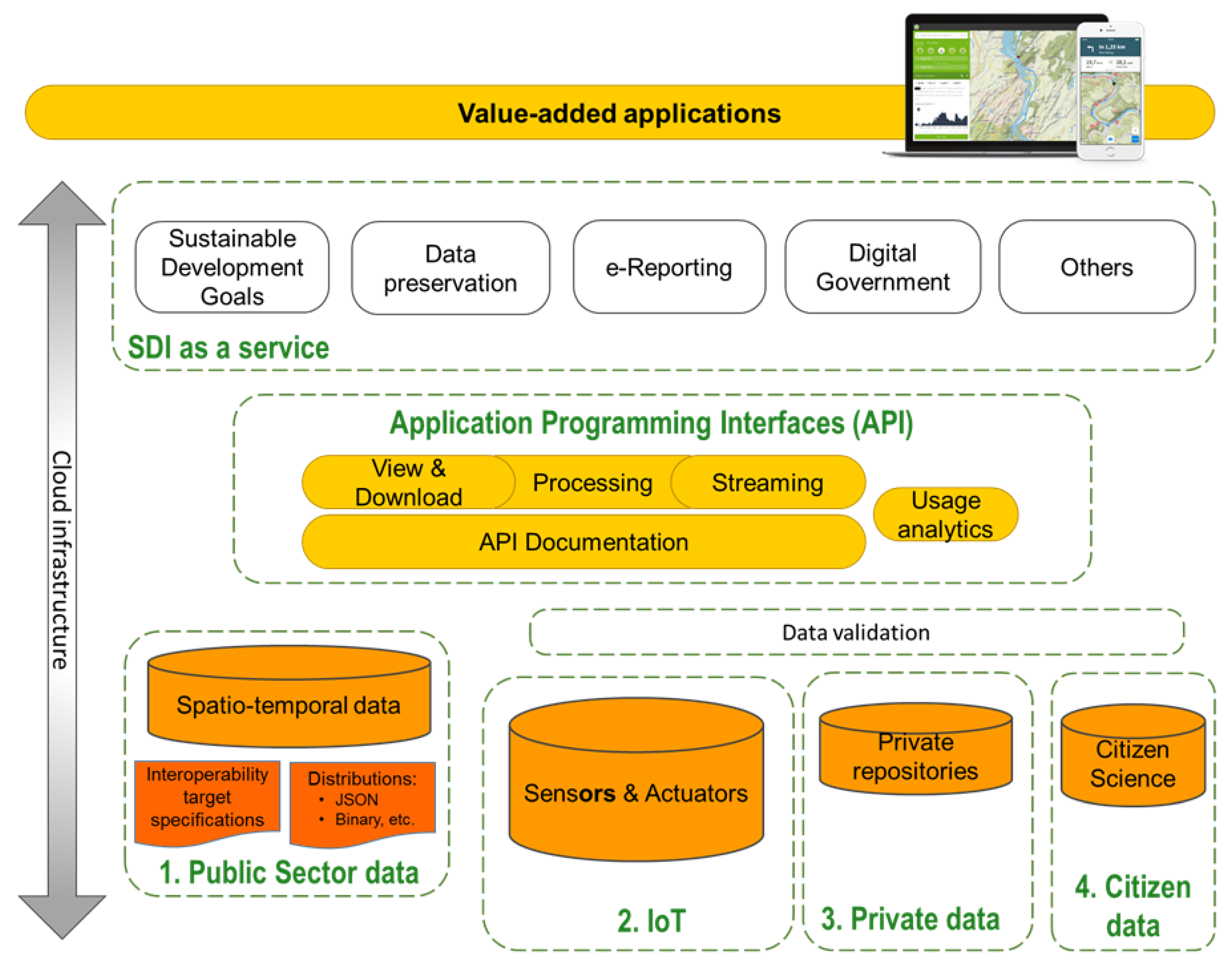
:
1. Introduction
Materials and Methods
2. Background
2.1. Spatial Data Infrastructures
2.2. The European Geospatial Data Landscape
2.2.1. Legislative Context
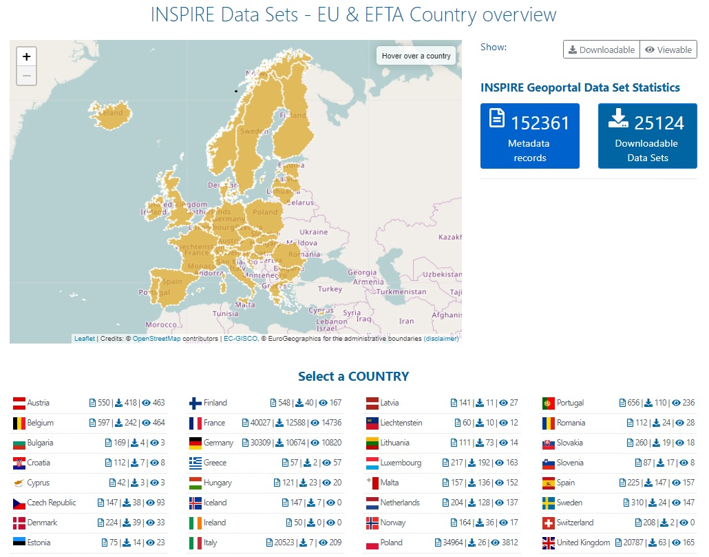
2.2.2. Availability of INSPIRE Data
3. Technological enablers
3.1. New Data Sources
3.1.1. Internet of Things (IoT)
3.1.2. Crowdsourced Geographic Information and Citizen Science
3.1.3. Data from Earth Observation Platforms
3.1.4. Private Sector Data
3.1.5. Open Research Data
3.2. New Architectures
3.2.1. Simple APIs
3.2.2. Data Streaming
3.2.3. Eventing and Asynchronous Data Transactions
3.2.4. Edge, Fog and Cloud Computing
3.3. Grassroots Standardisation
3.4. Growing Ecosystem of Software Tools
4. Europe’s SDI Post-2020
4.1. From Data Infrastructures to Data Spaces
4.2. Organisational Principles
4.2.1. Co-Design by Default
4.2.2. Simple Licensing Framework
4.3. Technical and Semantic Principles
4.3.1. Data Structures Based on Spatial Features
4.3.2. Encoding-Agnostic Approach
4.3.3. Mainstreaming IT-Related Developments
5. Conclusions
- Being able to understand the requirements of users in terms of content, data encodings and semantics and granularity is critically important. Harmonising and making data available that is of little interest to users, while not focusing on those datasets that are highly desired makes little sense. A mantra that is often heard at geospatial conferences is related to following the user. However, the concrete pragmatic approach for doing so is still missing. Within the emerging data space we see an opportunity for a more prominent role of users but also of data intermediaries that help bridge the gap between the provision and use of the data. In addition, the rise of AI, if combined with data mined from web access logs and other sources might provide valuable insights in resolving this issue. Once the data are used, it is essential that the concrete feedback of users is fed back into the data space thus improving and ensuring its sustainability.
- The governance of data in an increasingly complex setting is challenging. How to make the most out of the scattered resources while retaining sovereignty from big software platforms is to be addressed. Whatever the possible solution, the public sector has an important role to play. In addition, the organisational approaches for the establishment of operational data sharing arrangements, reflecting appropriate incentives that would guarantee stakeholder participation, are to be investigated. Numerous data-related novelties are successful at the urban and regional levels. How to scale and spread data-driven innovation is still not fully understood. While there is evidence on the success of data-related developments at the urban level, the higher the territorial level is, the weaker the evidence for success is, as is the sustainability of good practices.
- Regulatory aspects that would ensure that all involved actors such as the private sector and citizens can contribute, but also benefit from the emerging data spaces should be clarified.
- Finally, it is important to highlight that multiple data spaces can occur and co-exist at different territorial levels, which in turn would require the elaboration of organisational and technological approaches for coupling the different data spaces in a loose and flexible manner. The role of well-documented APIs can play a central role in this setting.
Author Contributions
Funding
Acknowledgments
Conflicts of Interest
References
- European Parliament and European Council. Directive 2007/2/EC of the European Parliament and of the Council of 14 March 2007 establishing an Infrastructure for Spatial Information in the European Community (INSPIRE). Off. J. Eur. Union 2007, L 108, 1–14. [Google Scholar]
- European Commission. INSPIRE Roadmap. 2020. Available online: https://inspire.ec.europa.eu/inspire-roadmap (accessed on 10 February 2020).
- European Commission. European Data Strategy. 2020. Available online: https://ec.europa.eu/info/strategy/priorities-2019-2024/europe-fit-digital-age/european-data-strategy_en (accessed on 28 February 2020).
- European Commission. The New European Interoperability Framework. 2017. Available online: https://ec.europa.eu/isa2/eif (accessed on 9 February 2020).
- Bernard, L.; Craglia, M.; Gould, M.; Kuhn, W. Towards an SDI research agenda. In Proceedings of the 11th EC GIS & GIS Workshop-ESDI: Setting the Framework-Abstracts Handbook, Alghero, Sardinia, Italy, 29 June–1 July 2005; pp. 147–151. [Google Scholar]
- Schade, S.; Granell, C.; Vancauwenberghe, G.; Keßler, C.; Vandenbroucke, D.; Masser, I.; Gould, M. Geospatial Information Infrastructures. In Manual of Digital Earth; Huadong, G., Goodchild, M.F., Annoni, A., Eds.; Springer: Singapore, 2020; pp. 161–190. [Google Scholar]
- Kotsev, A.; Peeters, O.; Smits, P.; Grothe, M. Building bridges: experiences and lessons learned from the implementation of INSPIRE and e-reporting of air quality data in Europe. Earth Sci. Informatics 2015, 8, 353–365. [Google Scholar] [CrossRef] [Green Version]
- Cetl, V.; Tomas, R.; Kotsev, A.; de Lima, V.N.; Smith, R.S.; Jobst, M. Establishing Common Ground Through INSPIRE: The Legally-Driven European Spatial Data Infrastructure. In Service-Oriented Mapping; Springer: Berlin, Germany, 2019; pp. 63–84. [Google Scholar]
- European Commission. Shaping the Digital Single Market. 2017. Available online: https://ec.europa.eu/digital-single-market/en/policies/shaping-digital-single-market (accessed on 9 February 2020).
- European Commission. Building a European Data Economy. 2017. Available online: https://ec.europa.eu/digital-single-market/news-redirect/624105 (accessed on 10 February 2020).
- European Commission. Tallinn Declaration on eGovernment at the ministerial meeting during Estonian Presidency of the Council of the EU on 6 October 2017. 2017. Available online: http://ec.europa.eu/newsroom/document.cfm?doc_id=47559 (accessed on 9 February 2020).
- European Commission. European eGovernment Action Plan 2016–2020. 2016. Available online: https://ec.europa.eu/digital-single-market/en/european-egovernment-action-plan-2016-2020 (accessed on 9 February 2020).
- Castelein, W.T.; Bregt, A.; Pluijmers, Y. The economic value of the Dutch geo-information sector. Int. J. Spat. Data Infrastruct. Res. 2010, 5, 58–76. [Google Scholar] [CrossRef]
- Oxera. What is the Economic Impact of Geo Services? Prepared for Google. 2013. Available online: https://www.oxera.com/publications/what-is-the-economic-impact-of-geo-services (accessed on 28 February 2020).
- Craglia, M.; Pogorzelska, K. The Economic Value of Digital Earth. In Manual of Digital Earth; Springer: Singapore, 2020; pp. 623–643. [Google Scholar] [CrossRef] [Green Version]
- European Parliament and European Council. Directive (EU) 2019/1024 of the European Parliament and of the Council of 20 June 2019 on open data and the re-use of public sector information (recast). Off. J. Eur. Union 2019, L172, 56–83. [Google Scholar]
- European Parliament and European Council. Directive 2003/98/EC of the European Parliament and of the Council of 17 November 2003 on the re-use of public sector information. Off. J. Eur. Union 2003, L345, 90–96. [Google Scholar]
- European Commission. Communication from the Commission to the European Parliament, the Council, the European Economic and Social Committee and the Committee of the Regions “Towards a common European data space”. 2018. Available online: https://eur-lex.europa.eu/legal-content/EN/TXT/PDF/?uri=CELEX:52018DC0232&from=EN (accessed on 9 February 2020).
- Wilkinson, M.D.; Dumontier, M.; Aalbersberg, I.J.; Appleton, G.; Axton, M.; Baak, A.; Blomberg, N.; Boiten, J.W.; da Silva Santos, L.B.; Bourne, P.E.; et al. The FAIR Guiding Principles for scientific data management and stewardship. Scientific Data 2016, 3, 1–10. [Google Scholar] [CrossRef] [Green Version]
- European Commission. Horizon 2020 Commission expert group on Turning FAIR data into reality (E03464). 2016. Available online: https://ec.europa.eu/transparency/regexpert/index.cfm?do=groupDetail.groupDetail&groupID=3464 (accessed on 10 February 2020).
- European Commission Expert Group on FAIR Data. Turning FAIR into reality: Final Report and Action Plan from the European Commission Expert Group on FAIR Data. 2018. Available online: http://0-dx-doi-org.brum.beds.ac.uk/10.2777/1524 (accessed on 10 February 2020).
- European Commission. European Open Science Cloud (EOSC). 2019. Available online: https://ec.europa.eu/research/openscience/index.cfm?pg=open-science-cloud (accessed on 10 February 2020).
- European Commission. Paris Agreement. 2015. Available online: https://ec.europa.eu/clima/policies/international/negotiations/paris_en (accessed on 10 February 2020).
- Von der Leyen, U. A Union that Strives for more—My Agenda for Europe: Political Guidelines for the Next European Commission 2019–2024. 2019. Available online: https://ec.europa.eu/commission/sites/beta-political/files/political-guidelines-next-commission_en.pdf (accessed on 10 February 2020).
- European Commission. Digital Europe Programme: A Proposed €9.2 Billion of Funding for 2021–2027. 2019. Available online: https://ec.europa.eu/digital-single-market/en/news/digital-europe-programme-proposed-eu92-billion-funding-2021-2027 (accessed on 10 February 2020).
- European Commission. The European Cloud Initiativel 2019. Available online: https://ec.europa.eu/digital-single-market/en/%20european-cloud-initiative (accessed on 10 February 2020).
- European Commission. Future of the Common Agricultural Policy. 2019. Available online: https://ec.europa.eu/info/food-farming-fisheries/key-policies/common-agricultural-policy/future-cap_en (accessed on 10 February 2020).
- European Commission. Europe’s Eyes on Earth: Looking at Our Planet and Its Environment for the Ultimate Benefit of all European Citizens. 2020. Available online: https://www.copernicus.eu (accessed on 10 February 2020).
- European Commission. Galileo. 2020. Available online: https://ec.europa.eu/growth/sectors/space/galileo_en (accessed on 10 February 2020).
- European Commission. EGNOS. 2019. Available online: https://ec.europa.eu/growth/sectors/space/egnos_en (accessed on 10 December 2019).
- European Parliament and European Council. Regulation (EU) 2016/679 of the European Parliament and of the Council of 27 April 2016 on the Protection of Natural Persons with Regard to the Processing of Personal Data and on the Free Movement of Such Data, and Repealing Directive 95/46/EC (General Data Protection Regulation); Office of the European Union: Brussels, Belgium, 2016. [Google Scholar]
- European Commission. INSPIRE Geoportal. 2020. Available online: https://inspire-geoportal.ec.europa.eu (accessed on 10 February 2020).
- Minghini, M.; Cetl, V.; Kotsev, A.; Tomas, R.; Lutz, M. INSPIRE: The entry point to Europe’s Big Geospatial Data Infrastructure. In Handbook of Big Geospatial Data; Springer: Berlin, Germany, 2020; in pressing. [Google Scholar]
- European Commission. MIWP Action 2016.5 Priority List of Datasets for e-Reporting. 2020. Available online: https://ies-svn.jrc.ec.europa.eu/projects/2016-5/wiki (accessed on 7 February 2020).
- European Commission. INSPIRE Data Themes. 2020. Available online: https://inspire.ec.europa.eu/Themes/Data-Specifications/2892 (accessed on 7 February 2020).
- Goodchild, M.F. Citizens as sensors: the world of volunteered geography. Geoj. 2007, 69, 211–221. [Google Scholar] [CrossRef] [Green Version]
- Wikimapia. 2019. Available online: https://wikimapia.org (accessed on 10 December 2019).
- OpenStreetMap. 2020. Available online: https://www.openstreetmap.org (accessed on 9 February 2020).
- Turner, A. Introduction to Neogeography; O’Reilly Media: Sebastopol, CA, USA, 2006; pp. 10–20. [Google Scholar]
- De Mauro, A.; Greco, M.; Grimaldi, M. What is big data? A consensual definition and a review of key research topics. In Proceedings of the International Conference on Integrated Information (IC-ININFO 2014), Madrid, Spain, 5–8 September 2014. [Google Scholar]
- Cappè, S.; Gilsenan, M.; O’Dea, E.; Richardson, J.; Verloo, D. The future of data in EFSA. EFSA J. 2019, 17, e17011. [Google Scholar] [CrossRef]
- Haklay, M. How good is volunteered geographical information? A comparative study of OpenStreetMap and Ordnance Survey datasets. Environ. Plan. Plan. Des. 2010, 37, 682–703. [Google Scholar] [CrossRef] [Green Version]
- Girres, J.F.; Touya, G. Quality assessment of the French OpenStreetMap dataset. Trans. Gis 2010, 14, 435–459. [Google Scholar] [CrossRef]
- Fan, H.; Zipf, A.; Fu, Q.; Neis, P. Quality assessment for building footprints data on OpenStreetMap. Int. J. Geogr. Inf. Sci. 2014, 28, 700–719. [Google Scholar] [CrossRef]
- Facebook. Mapping Roads through Deep Learning and Weakly Supervised Training. 2019. Available online: https://ai.facebook.com/blog/mapping-roads-through-deep-learning-and-weakly-supervised-training (accessed on 9 February 2020).
- Swan, M. Sensor mania! the internet of things, wearable computing, objective metrics, and the quantified self 2.0. J. Sens. Actuator Networks 2012, 1, 217–253. [Google Scholar] [CrossRef] [Green Version]
- Kamilaris, A.; Ostermann, F. Geospatial Analysis and Internet of Things in Environmental Informatics. arXiv 2018, arXiv:1808.01895. [Google Scholar]
- Mcdougall, K.; Koswatte, S. The future of authoritative geospatial data in the big data world—Trends, opportunities and challenges. In Proceedings of the FIG Commission: Spatial Information in an Era of Data Science: Challenges and Practical Solutions, Naples, Italy, 3–6 December 2018; pp. 3–6. [Google Scholar]
- Granell, C.; Kamilaris, A.; Kotsev, A.; Ostermann, F.O.; Trilles, S. Internet of Things in Geospatial Analytics. In Manual of Digital Earth; Huadong, G., Goodchild, M.F., Annoni, A., Eds.; Springer: Singpore, 2020; pp. 387–423. [Google Scholar]
- See, L.; Mooney, P.; Foody, G.; Bastin, L.; Comber, A.; Estima, J.; Fritz, S.; Kerle, N.; Jiang, B.; Laakso, M.; et al. Crowdsourcing, citizen science or volunteered geographic information? The current state of crowdsourced geographic information. ISPRS Int. J. -Geo-Inf. 2016, 5, 55. [Google Scholar] [CrossRef]
- Mooney, P.; Minghini, M. A Review of OpenStreetMap Data. In Mapping and the Citizen Sensor; Foody, G., Fritz, S., Mooney, P., Olteanu-Raimond, A.M., Fonte, C.C., Antoniou, V., Eds.; Ubiquity Press: London, UK, 2017; pp. 37–59. [Google Scholar] [CrossRef] [Green Version]
- OpenStreetMap Wiki—Elements. 2020. Available online: https://wiki.openstreetmap.org/wiki/Elements (accessed on 9 February 2020).
- OpenStreetMap Wiki—Tags. 2020. Available online: https://wiki.openstreetmap.org/wiki/Tags (accessed on 9 February 2020).
- OpenStreetMap Wiki—Import/Catalogue. 2020. Available online: https://wiki.openstreetmap.org/wiki/Import/Catalogue (accessed on 9 February 2020).
- Minghini, M.; Kotsev, A.; Lutz, M. Comparing INSPIRE and OpenStreetMap data: How to make the most out of the two worlds. Int. Arch. Photogramm. Remote Sens. Spat. Inf. Sci. 2019, XLII-4/W14, 167–174. [Google Scholar] [CrossRef] [Green Version]
- Senaratne, H.; Mobasheri, A.; Ali, A.L.; Capineri, C.; Haklay, M. A review of volunteered geographic information quality assessment methods. Int. J. Geogr. Inf. Sci. 2017, 31, 139–167. [Google Scholar] [CrossRef]
- Irwin, A. Citizen Science: A Study of People, Expertise and Sustainable Development; Routledge: London, UK, 2002. [Google Scholar]
- Schade, S.; Kotsev, A.; Cardoso, A.C.; Tsiamis, K.; Gervasini, E.; Spinelli, F.; Mitton, I.; Sgnaolin, R. Aliens in Europe. An open approach to involve more people in invasive species detection. Comput. Environ. Urban Syst. 2019, 78, 101384. [Google Scholar] [CrossRef]
- Sweeting, M.N. Modern small satellites-changing the economics of space. Proc. IEEE 2018, 106, 343–361. [Google Scholar] [CrossRef]
- Remondino, F.; Barazzetti, L.; Nex, F.; Scaioni, M.; Sarazzi, D. UAV photogrammetry for mapping and 3D modeling – Current status and future perspectives. Int. Arch. Photogramm. Remote Sens. Spat. Inf. Sci. 2011, XXXVIII-1/C22, 25–31. [Google Scholar]
- European Commission. Legal notice on the use of Copernicus Sentinel Data and Service Information. 2019. Available online: https://sentinel.esa.int/documents/247904/690755/Sentinel_Data_Legal_Notice (accessed on 9 February 2020).
- Bai, Y.; Jacobs, C.A.; Kwan, M.P.; Waldmann, C. Geoscience and the Technological Revolution [Perspectives]. IEEE Geosci. Remote Sens. Mag. 2017, 5, 72–75. [Google Scholar] [CrossRef]
- Ricciato, F.; Widhalm, P.; Craglia, M.; Pantisano, F. Estimating Population Density Distribution from Network-Based Mobile Phone Data, 1st ed.; Joint Research Centre: Ispra, Italy, 2015; pp. 1–64. [Google Scholar]
- Keßler, C.; McKenzie, G. A geoprivacy manifesto. Trans. Gis 2018, 22, 3–19. [Google Scholar] [CrossRef] [Green Version]
- Multidisciplinary Digital Publishing Institute). Data—Open Access Journal. 2020. Available online: https://0-www-mdpi-com.brum.beds.ac.uk/journal/data (accessed on 10 February 2020).
- Elsevier. Data in Brief. 2020. Available online: https://0-www-journals-elsevier-com.brum.beds.ac.uk/data-in-brief (accessed on 10 February 2020).
- SpringerOpen. Open Geospatial Data, Software and Standards. 2020. Available online: https://opengeospatialdata.springeropen.com/ (accessed on 10 February 2020).
- Nüst, D.; Ostermann, F.; Sileryte, R.; Hofer, B.; Granell, C.; Teperek, M.; Graser, A.; Broman, K.; Hettne, K. Reproducible Publications at AGILE Conferences. 2019. Available online: https://osf.io/phmce/ (accessed on 12 December 2019).
- Open Geospatial Consortium. OGC API—Features Standard. 2019. Available online: https://www.opengeospatial.org/standards/ogcapi-features (accessed on 10 February 2020).
- Open Geospatial Consortium. OGC SensorThings API Standard. 2016. Available online: https://www.opengeospatial.org/standards/sensorthings (accessed on 10 February 2020).
- OpenAPI Specification, Version 3.0.2. 2018. Available online: https://swagger.io/specification (accessed on 9 February 2020).
- Rieke, M.; Bigagli, L.; Herle, S.; Jirka, S.; Kotsev, A.; Liebig, T.; Malewski, C.; Paschke, T.; Stasch, C. Geospatial IoT—The need for event-driven architectures in contemporary spatial data infrastructures. ISPRS Int. J. -Geo-Inf. 2018, 7, 385. [Google Scholar] [CrossRef] [Green Version]
- International Data Corporation. Market Analysis Perspective: Worldwide Core and Edge Computing Platforms. 2018. Available online: https://www.idc.com/getdoc.jsp?containerId=US44305818 (accessed on 28 February 2020).
- Setting up an INSPIRE Download Service Based on the OGC API-Features Standard. 2019. Available online: https://github.com/INSPIRE-MIF/gp-ogc-api-features/blob/master/spec/oapif-inspire-download.md (accessed on 10 February 2020).
- Kotsev, A.; Schleidt, K.; Liang, S.; Van Der Schaaf, H.; Khalafbeigi, T.; Grellet, S.; Lutz, M.; Jirka, S.; Beaufils, M. Extending INSPIRE to the Internet of Things through SensorThings API. Geosci. 2018, 8, 221. [Google Scholar] [CrossRef] [Green Version]
- Creative Commons Licenses. 2020. Available online: https://creativecommons.org/use-remix/cc-licenses/ (accessed on 9 February 2020).
- INSPIRE Data Specifications. 2020. Available online: https://inspire.ec.europa.eu/data-specifications/2892 (accessed on 5 February 2020).
- INSPIRE Consolidated UML Model. 2020. Available online: https://inspire.ec.europa.eu/data-model/approved/r4618-ir/html (accessed on 9 February 2020).
- Wieczorek, J.; Bloom, D.; Guralnick, R.; Blum, S.; Döring, M.; Giovanni, R.; Robertson, T.; Vieglais, D. Darwin Core: An evolving community-developed biodiversity data standard. PLoS ONE 2012, 7, e29715. [Google Scholar] [CrossRef] [PubMed]
- Open Geospatial Consortium. Geography Markup Language (GML). 2007. Available online: https://www.opengeospatial.org/standards/gml (accessed on 9 February 2020).
- Butler, H.; Daly, M.; Doyle, A.; Gillies, S.; Hagen, S.; Schaub, T. The Geojson Format. Available online: http://www.hjp.at/doc/rfc/rfc7946.html (accessed on 2 January 2020).
- World Wide Web Consortium (W3C). Data Catalog Vocabulary (DCAT)—Version 2. 2020. Available online: https://www.w3.org/TR/vocab-dcat-2/#Property:dataset_distribution (accessed on 9 February 2020).


© 2020 by the authors. Licensee MDPI, Basel, Switzerland. This article is an open access article distributed under the terms and conditions of the Creative Commons Attribution (CC BY) license (http://creativecommons.org/licenses/by/4.0/).
Share and Cite
Kotsev, A.; Minghini, M.; Tomas, R.; Cetl, V.; Lutz, M. From Spatial Data Infrastructures to Data Spaces—A Technological Perspective on the Evolution of European SDIs. ISPRS Int. J. Geo-Inf. 2020, 9, 176. https://0-doi-org.brum.beds.ac.uk/10.3390/ijgi9030176
Kotsev A, Minghini M, Tomas R, Cetl V, Lutz M. From Spatial Data Infrastructures to Data Spaces—A Technological Perspective on the Evolution of European SDIs. ISPRS International Journal of Geo-Information. 2020; 9(3):176. https://0-doi-org.brum.beds.ac.uk/10.3390/ijgi9030176
Chicago/Turabian StyleKotsev, Alexander, Marco Minghini, Robert Tomas, Vlado Cetl, and Michael Lutz. 2020. "From Spatial Data Infrastructures to Data Spaces—A Technological Perspective on the Evolution of European SDIs" ISPRS International Journal of Geo-Information 9, no. 3: 176. https://0-doi-org.brum.beds.ac.uk/10.3390/ijgi9030176