Editorial

Digital Twin and CyberGIS for Improving Connectivity and Measuring the Impact of Infrastructure Construction Planning in Smart Cities

1
Faculty of Built Environment, University of New South Wales, Sydney, NSW 2052, Australia
2
Department of Building, National University of Singapore, Lower Kent Ridge Road, Singapore 117566, Singapore
*
Author to whom correspondence should be addressed.
ISPRS Int. J. Geo-Inf. 2020, 9(4), 240; https://0-doi-org.brum.beds.ac.uk/10.3390/ijgi9040240
Submission received: 7 April 2020 / Accepted: 8 April 2020 / Published: 12 April 2020

Abstract

:
Smart technologies are advancing, and smart cities can be made smarter by increasing the connectivity and interactions of humans, the environment, and smart devices. This paper discusses selective technologies that can potentially contribute to developing an intelligent environment and smarter cities. While the connectivity and efficiency of smart cities is important, the analysis of the impact of construction development and large projects in the city is crucial to decision and policy makers, before the project is approved. This raises the question of assessing the impact of a new infrastructure project on the community prior to its commencement—what type of technologies can potentially be used for creating a virtual representation of the city? How can a smart city be improved by utilizing these technologies? There are a wide range of technologies and applications available but understanding their function, interoperability, and compatibility with the community requires more discussion around system designs and architecture. These questions can be the basis of developing an agenda for further investigations. In particular, the need for advanced tools such as mobile scanners, Geospatial Artificial Intelligence, Unmanned Aerial Vehicles, Geospatial Augmented Reality apps, Light Detection, and Ranging in smart cities is discussed. In line with smart city technology development, this Special Issue includes eight accepted articles covering trending topics, which are briefly reviewed.

1. Introduction

From the practical perspective, a smart city has the capability to capture real-time data that are communicated among stakeholders for optimizing decision-making by deploying artificial intelligence. This is achievable by making activities, services, and businesses smart, e.g., smart real estate, smart transportation, smart construction, smart healthcare system, smart building, smart home, smart transportation, and smart parking. For example, Virtual Singapore [1] is a dynamic 3D city model with a collaborative platform and data sharing system. This virtual city was initiated and funded by the National Research Foundation (NRF) with a $73 million investment.
Over the past year, the number of mobile users has increased by over two percent, up to 5.11 billion globally [2]. The number of internet users is also increasing. Due to the current Covid-19 outbreak, many people are working from home (WfH) and shop using online platforms. Geographic Information Science and System (GIS—Geographic Information Systems) technologies and IT services are used to analyse spatial and temporal data collected from various organisations to get better insights regarding current trends and model future trends and their impacts on communities and well-being. This big shift from traditional workplaces and shopping towards WfH and online shopping underscores the importance of further developing smart city infrastructures and deploying geospatial technologies to address future needs. This paper identifies selected trends in geospatial science, particularly the applications of GIS. In addition, this paper observes newly developed online apps such as ArcGIS Urban, used for predicting future impacts of developing urban areas in three dimensions. These technologies provide useful tools for smart city stakeholders and users to predict future implications of the proposed plans and collaborate with the organisations to achieve more appropriate outcomes, considering various criteria including sustainable development goals (SDGs) at various scales.
Digital twins of cities have recently attracted much attention as a useful virtual platform that captures changes to the physical environment in the city and all associated activities and movements [3]. Figure 1a–d schematically illustrate a digital–physical twin of a smart city, including the data management process and dashboard development. Figure 1e,f shows some examples developed by the first author. Using sensors, Unmanned Aerial Vehicles (UAVs), satellites, and different technologies, the physical entities, activities, behaviours, and interactions are required to be connected to a digital model [3] for a more realistic data platform. Integration of the digital twin as a 3D representation of the city and associated information can be used for the assessment of the performance of the city and selected construction projects using a data management system. Apps such as ArcGIS urban can also help us to evaluate the impact of a new project before it is implemented. Such digital twins, in conjunction with sensors and other advanced data collection technologies, can help in better modelling the strategic behaviours of agents [4].
This editorial is divided into two sections: (i) the development of advanced tools such as miniaturization of sensors and mobile scanners, geospatial AI, Unmanned Aerial Vehicles (UAVs), geospatial AR apps, and Light Detection and Ranging (Lidar); as well as (ii) applications of the tools in cities and products such as Self-Driving Vehicles and Smart Cities. Finally, the papers included in this Special Issue are reviewed.

2. Advanced Technologies
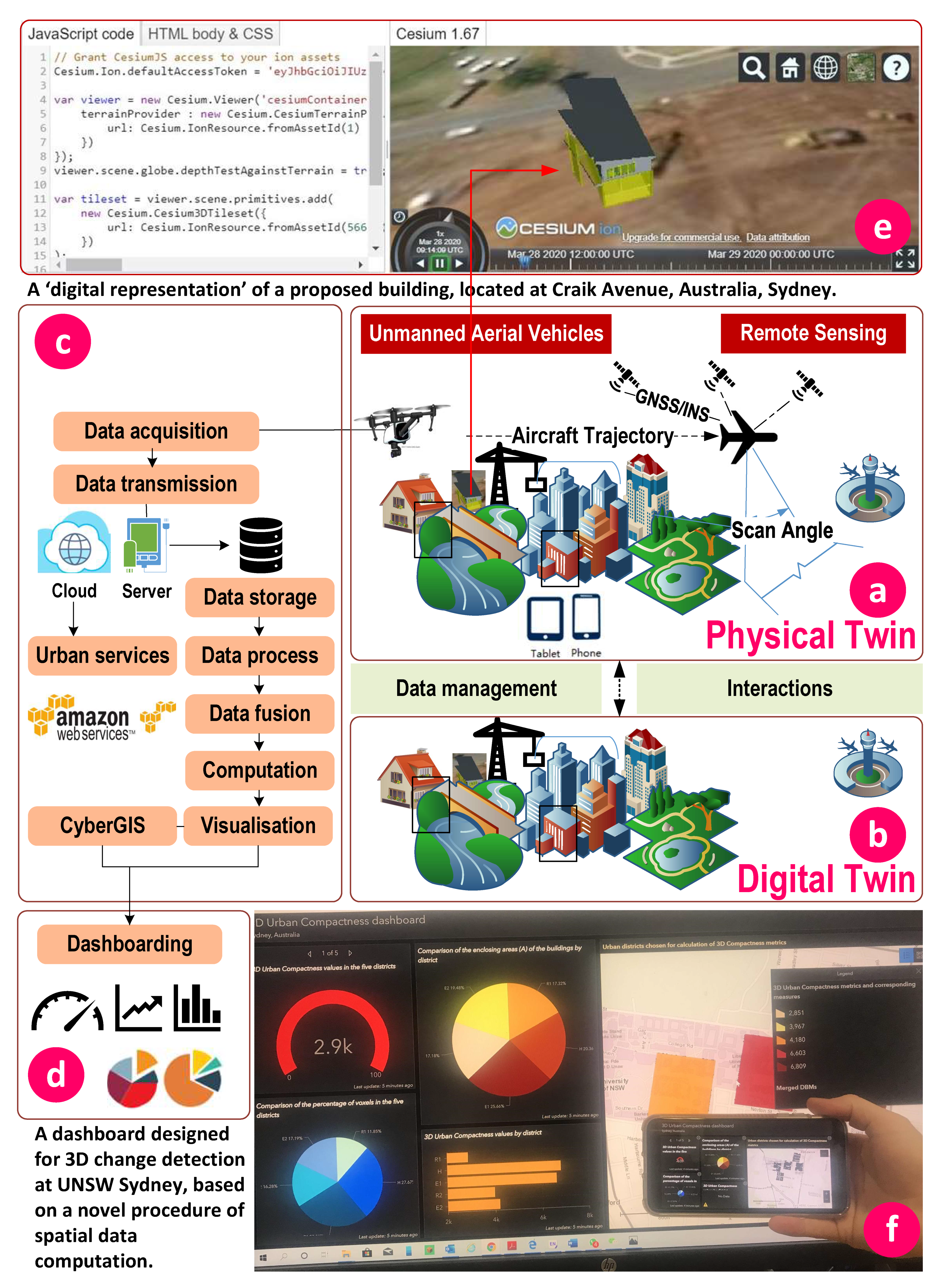
This section introduces the different tools and technologies that are critical to create a digital twin for a smart city. These critical technologies include network technology, sensors, artificial intelligence, big data, and Lidar technologies [5]. The integration of sensors with GIS in city analytics is a new geospatial trend that can significantly improve smart city technology. While the cost of utilizing such sensors is high, another emerging trend is to miniaturize sensors and data acquisition tools such as innovative bee-sized drones and mini satellites to generate useful data in an efficient and cost-effective manner. Selected technologies useful to improve the connectivity in smart cities which can be used for digital-physical twin are discussed as follows but can be further investigated in the future (See Figure 1).

2.1. CyberGIS

The combination of cyber infrastructure and GIS offers new capacity for online spatial analysis as a new generation of GIS. In practice, CyberGIS refers to the deployment of GIS on a web platform instead of running from a single desktop. CyberGIS Gateway, Toolkit, and Middleware can enable CyberGIS to offer open source, open access, and the possibility of integration [6,7,8]. CyberGIS analytics deal with interoperability of geospatial big data [9] and processing software programs [7]. The implementation of CyberGIS involves in many issues such as cloud base working, hardware/software challenges, internet speed, and the availability of skilled people to prepare, process, and use it. Advances in cloud computing, web mapping, and new algorithms for spatial data analysis in a quicker manner and including more dimensions of data (such as voxels instead of pixels) are required. CyberGIS also offers real-time accessibility to the outcome of computations, and dashboards to monitor changes and trends as well as gain insights from the available data connected to the dashboards. High-performance computing and networking (HPCN) (including CyberGIS) enables parallel processing used for running big GIS data and CyberGIS applications quickly and efficiently. Since big data is generated in different businesses, applying HPCN in GIS can be further investigated in different contexts.

2.2. Integration of GIS and BIM

While GIS is becoming more intelligent using cyberinfrastructure, its indoor applications also will be further developed. In this situation, Building Information Modelling (BIM), as a rich dataset for buildings including detailed information of the indoor built environment, will be helpful if fully available [10]. In this case, the integration of GIS and BIM will bring more advantages to the data sets including the combination of large- and small-scale built environments, looking at BIM models in a broader context of 3D geographic location, producing a more realistic model of built environments including buildings, vegetation, terrain, road network, and agents. For such integration, there are interoperability issues and factors, as Shirowzhan, Sepasgozar [11] discussed recently.
For real-time visualization and near real-time analysis of streaming data within GIS environments, technologies such as the Internet of Things are required to be interoperable with CyberGIS. The real-time output also depends on reliable “geospatial big data” computation algorithms to deal with volume, variety, and velocity of data [12,13,14,15]. There remains geospatial big data challenges that should be investigated in terms of availability of data on multi-cloud models, data integrity, data standards, and heterogeneity.

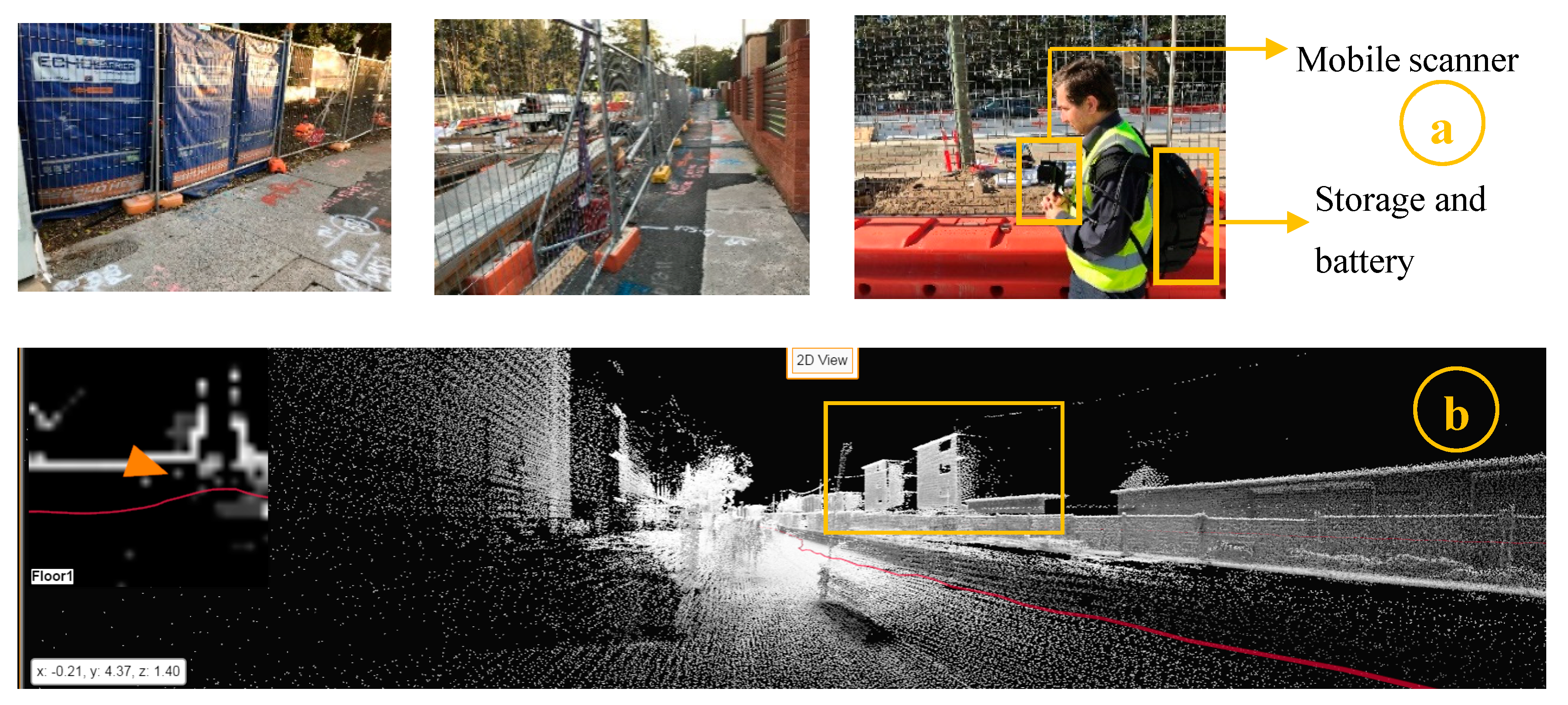
2.3. Laser Scanning Technologies

In recent years, laser scanning technology has been increasingly used for different purposes, including construction projects [16,17], for the provision of high-resolution point clouds of complex objects [18,19]. Another important application of point clouds is to track the physical progress of buildings and urban developments [20]. Progress tracking is the process of identifying differences and/or geometrical changes in an object over a specified period [21,22]. Monitoring physical progress in construction projects is crucial for measuring efficiency and productivity, but the current practice is cumbersome and complicated. In addition to these applications, laser scanners can be used to collect high point density data with a high level of accuracy, fine spatial resolution and in a shorter time for deformation detection [23,24]. For these applications, a wide range of algorithms and methods are utilized to optimize point cloud processing including filtering, simplification, feature recognition, segmentation, and registration [25]. Despite all these applications of point clouds, the use of laser scanning for deformation monitoring, 3D change detection, and volume estimation using bi-temporal datasets is still in infancy [20,26,27]. One of the challenges of deformation or change detection over time, on a regular basis, is related to handling the extremely large volume of point cloud data. Figure 2 illustrates a field point cloud data set for a light rail infrastructure. One can envision how big the data set will be if a practitioner continues the data collection task every day for a year or two. A handheld mobile scanner, Zeb Revo, was used to collect point cloud data on different occasions. As Sepasgozar, Forsythe [22] mentioned, the advantage of this type of mobile scanners is to collect data from surface objects easily and quickly.

2.4. Machine/Deep Learning Algorithms

Machine/deep learning algorithms are in use for processing various types of data, including images and point clouds. These algorithms are used for the detection of objects and changes. These algorithms have also been used for Artificial Intelligence and the detection of moving objects such as the identification of hats on/off workers in a construction site for monitoring safety in a workplace.
There are several algorithms including machine/deep learning methods available for processing Lidar point clouds and spatial data sets to achieve a reliable result for change detection of moving objects [25,28,29]. For example, Shirowzhan, Sepasgozar [25] applied machine learning and point-based algorithms to show 3D changes of urban environment over time using bi-temporal point clouds. Many algorithms have been proposed, such as the Iterative Closest Point (ICP) [30], Cloud to Cloud (C2C) method [31], and Multiscale Model to Model Cloud Comparison (M3C2) Lagüela, Díaz-Vilariño [32]. In M3C2, specifications of the point cloud, such as density, affect the choice of the main normal direction. If the changes are mainly in vertical dimension, such as in airborne point clouds, then the vertical normal should be chosen for the normal direction. However, the current algorithms need to be further extended and modified to be able to deal with spatiotemporal big data enabling three-dimensional modelling and visualization.

2.5. High Performance Computing

Recent publications tend to use spatiotemporal computing or different approaches of high-performance computing on modelling vector-borne disease transmission [33] and crime analysis [34]. Other studies also used digital twin applications to improve disaster management. Fan, Zhang [4] utilized a digital twin for use in disaster management using crisis informatics and information in a cyber infrastructure. They suggested a dynamic network analysis and a gaming approach for modelling behaviours of multi-actors and evaluating the performance of resilience and relief efforts.

3. Smart Cities Including Smart Elements

The technological part of a smart city refers to the use of information systems for planning, controlling, and managing critical infrastructure [35,36]. Recently, a wide range of tools and applications have been introduced to facilitate implementing smart cities and capturing user behaviour from different social and managerial perspectives [37]. A wider range of geo-spatial technologies are required for smart cities in order to generate data and monitor changes over time in the city. For example, hand-held mobile scanners can collect data on a daily basis and help practitioners to process changes over time (see Figure 2). The point clouds generated on a daily task can be communicated with other stakeholders and experts using cloud base platforms. However, challenges of big data analysis, interoperability, and implementations need to be investigated and resolved first. For digital twin applications in smart cities, agent’s behaviour also need to be reflected and modelled within the geospatial platforms. There are still gaps in this domain, including modelling the dynamic behaviour of interacting subsystems suggested by Lom and Pribyl [38]. They also recommend investigating the behaviour of smart city agents and the identification of the details of subsystem behaviour as well as efficient ways of information exchange. In addition, for such applications, the interoperability of systems such as GIS with BIM and virtual/augmented reality applications is still challenging [11].
One challenge on the path towards smarter cities is to develop multi-criteria decision-making models and simulation scenarios. One of the recently developed applications by ESRI, i.e., ArcGIS Urban, is a type of appropriate application suitable for multi-criteria decision making in 3D urban environments. Nowadays, dashboards are being increasingly used for the provision of better insights for informed decision making in smart cities. These dashboards are connected to the sensors that provide data and using these dashboards experts can monitor current situations, changes and make smarter data driven decisions. Of course, these sensors produce big data sets that need to be stored and analyzed and cloud-based GIS platforms (refer to CyberGIS here) are most appropriate for dealing with such huge data sets.
Relevant and insightful case studies on CyberGIS implementation requires the identification of the challenges in a cloud-based working environment, hardware/software interoperability, speed of internet, ease-of-use application developments, and accessibility of the application to users.
There is also an urgent need to connect the online GIS tools to the supercomputing environment gateways for the projects with very big data sets. Advances in cloud computing, web mapping, and new algorithms for spatial 3D data processing and analysis using voxels are also required for acceleration of smart city developments considering more dimensions of urban developments.
An agenda for further investigation for smart cities and CyberGIS is to identify factors influencing the technology adoption process. There are several concepts which should be examined separately such as business readiness in utilizing new technologies, technology adoption [39], diffusion [40], technology dissemination [41], and implementation process [42,43]. This requires the development a taxonomy of technologies for the better understanding of different available technologies in smart cities. This practice has started in the construction field, where Sepasgozar and Davis [44] categorized technologies based on their adoption issues. Adopting this categorization, the useful technologies for smart cities are (i) network and office work technologies as highly penetrated information technologies (IT) and information and communication technologies (ICT) influencing human productivity, e-commerce, urban services [37], e-government [45], agriculture, and e-banking in smart cities. Recently, many communication technologies have arisen, such as social media [46], Skype, Teams, and Zooms which are known to be useful for working from home or working remotely which are critical for smarter cities; (ii) design technologies such as Building Information Modelling (BIM) [11,47], Geographic Information Systems (GIS), and CyberGIS [18,48]; (iii) sensing technologies such as wearable sensors [49], RFID [50,51], IoT sensors, real time locating systems (RTLS) [52], laser scanners [22], GPS, Radar, cameras for smart transportation, smart parking, and smart construction (job-site management, tracking materials, site management, physical progress monitoring, and productivity, safety, emission [53,54], security, and remote controlling devices and diagnostic systems attached or imbedded in heavy equipment such as Grader or Crane); (iv) production technologies such as 3D Printing [55,56]; and (v) virtual technologies such as mixed reality and digital twin.

4. Topics Covered in This Issue

While selected topics of trending technologies and emerging issues were briefly discussed in the previous sections, this section reviews some of related topics addressed in the Special Issue.
Mendoza-Silva, Gould [57] offer a simulator for improving the smart parking practices by modelling drivers with activity plans. This experimental study offers a parking occupancy simulator to support a smart system for managing parking. This paper is critical for use in extending smart city practices, as it shows how the process of developing a simulator assists in smart parking development from design to implementation.
Gu, Zhu [58] propose a bike optimization algorithm to increase the efficiency of bike stations and the sharing system in the case of Shenzhen in China. Station-free bike sharing systems were recently introduced in China in line with smart city practices. They propose an optimization algorithm to match bike offers and rides.
Wu, Liu [59] use an agent-based model simulation of human mobility with the use of mobile phone datasets and spatial big data analysis. They identify individual travels in urban areas and simulate commuting behaviours of residents using an agent-based model.
Rupi, Poliziani [60] describe the use of numerical methods to match the network demand and supply of bicycles. This is a useful study in the improvement of the city infrastructure using spatial data sets.
Li, Guo [61] investigate the distribution of railways in China using indicators such as network density, proximity, travel time, train frequency, population, and Gross Domestic Product (GDP). They then evaluated China’s railway network distribution using GIS.
Dong, Yuan [62] present a novel algorithm of direction-aware continuous moving K-nearest neighbor queries in road networks. They showed how object azimuth information can be used to determine the moving direction towards the query object.
Wang, Sun [63] propose a hybrid framework for the high-performance modelling of 3D pipe networks. Three-dimensional modeling is a trending topic in smart city literature [25,64]. They explain how instantiation technology significantly improves the rendering performance of the 3D pipe networks.
Han et al. [65] present an efficient staged evacuation planning algorithm for multi-exit buildings. This algorithm can be tested using advanced big data simulations and virtual reality technologies.

Author Contributions

All authors involved in writing-review and editing. All authors have read and agreed to the published version of the manuscript.

Funding

This research received no external funding.

Conflicts of Interest

The authors declare no conflict of interest.

References

  1. National Research Foundation (NRF). Virtual Singapore. 2020 28/03/2020. Available online: https://www.nrf.gov.sg/programmes/virtual-singapore (accessed on 28 March 2020).
  2. Kemp, S. Digital 2019: Global Internet Use Accelerates. 2020. Available online: https://wearesocial.com/blog/2019/01/digital-2019-global-internet-use-accelerates (accessed on 28 March 2020).
  3. Qi, Q.; Tao, F.; Hu, T.; Anwer, N.; Liu, A.; Wei, Y.; Wang, L.; Nee, A. Enabling technologies and tools for digital twin. J. Manuf. Syst. 2019. [Google Scholar] [CrossRef]
  4. Fan, C.; Zhang, C.; Yahja, A.; Mostafavi, A. Disaster City Digital Twin: A vision for integrating artificial and human intelligence for disaster management. Int. J. Inf. Manag. 2019, 102049. [Google Scholar] [CrossRef]
  5. Shirowzhan, S.; Sepasgozar, S.; Li, H.; Trinder, J. Spatial compactness metrics and Constrained Voxel Automata development for analyzing 3D densification and applying to point clouds: A synthetic review. Autom. Constr. 2018, 96, 236–249. [Google Scholar] [CrossRef]
  6. Wang, S.; Liu, Y.Y.; Padmanabhan, A. Open cyberGIS software for geospatial research and education in the big data era. SoftwareX 2016, 5, 1–5. [Google Scholar] [CrossRef] [Green Version]
  7. Liu, Y.Y.; Padmanabhan, A.; Wang, S. CyberGIS Gateway for enabling data-rich geospatial research and education. Concurr. Comput. Pract. Exp. 2014, 27, 395–407. [Google Scholar] [CrossRef]
  8. Wang, S. A CyberGIS Framework for the Synthesis of Cyberinfrastructure, GIS, and Spatial Analysis. Ann. Assoc. Am. Geogr. 2010, 100, 535–557. [Google Scholar] [CrossRef]
  9. Shirowzhan, S.; Lim, S.; Trinder, J.; Li, H.; Sepasgozar, S. Data mining for recognition of spatial distribution patterns of building heights using airborne lidar data. Adv. Eng. Inform. 2020, 43, 101033. [Google Scholar] [CrossRef]
  10. Vilutiene, T.; Hosseini, M.R.; Pellicer, E.; Zavadskas, E.K. Advanced BIM Applications in the Construction Industry. Adv. Civ. Eng. 2019, 2019, 6356107. [Google Scholar] [CrossRef]
  11. Shirowzhan, S.; Sepasgozar, S.M.; Edwards, D.J.; Li, H.; Wang, C. BIM compatibility and its differentiation with interoperability challenges as an innovation factor. Autom. Constr. 2020, 112, 103086. [Google Scholar] [CrossRef]
  12. Kumar, B.; Pandey, G.; Lohani, B.; Misra, S.C. A multi-faceted CNN architecture for automatic classification of mobile LiDAR data and an algorithm to reproduce point cloud samples for enhanced training. ISPRS J. Photogramm. Remote Sens. 2019, 147, 80–89. [Google Scholar] [CrossRef]
  13. Deng, X.; Liu, P.; Liu, X.; Wang, R.; Zhang, Y.; He, J.; Yao, Y. Geospatial Big Data: New Paradigm of Remote Sensing Applications. IEEE J. Sel. Top. Appl. Earth Obs. Remote Sens. 2019, 12, 3841–3851. [Google Scholar] [CrossRef]
  14. Deibe, D.; Amor, M.; Doallo, R. Big Data Geospatial Processing for Massive Aerial LiDAR Datasets. Remote Sens. 2020, 12, 719. [Google Scholar] [CrossRef] [Green Version]
  15. Barik, R.K.; Misra, C.; Lenka, R.K.; Dubey, H.; Mankodiya, K. Hybrid mist-cloud systems for large scale geospatial big data analytics and processing: Opportunities and challenges. Arab. J. Geosci. 2019, 12, 32. [Google Scholar] [CrossRef]
  16. Louis, J.; Dunston, P.S. Methodology for Real-Time Monitoring of Construction Operations Using Finite State Machines and Discrete-Event Operation Models. J. Constr. Eng. Manag. 2017, 143, 04016106. [Google Scholar] [CrossRef]
  17. Sepasgozar, S.; Wang, C.; Shirowzhan, S. Challenges and Opportunities for Implementation of Laser Scanners in Building Construction. In Proceedings of the 33rd International Symposium on Automation and Robotics in Construction (ISARC 2016), Auburn, AL, USA, 18–21 July 2016. [Google Scholar]
  18. Shirowzhan, S.; Sepasgozar, S. Spatial Analysis Using Temporal Point Clouds in Advanced GIS: Methods for Ground Elevation Extraction in Slant Areas and Building Classifications. ISPRS Int. J. Geo Inf. 2019, 8, 120. [Google Scholar] [CrossRef] [Green Version]
  19. Shirowzhan, S.; Lim, S.; Trinder, J. Enhanced Autocorrelation-Based Algorithms for Filtering Airborne Lidar Data over Urban Areas. J. Surv. Eng. 2016, 142, 04015008. [Google Scholar] [CrossRef] [Green Version]
  20. Shirowzhan, S.; Sepasgozar, S.; Liu, C. Monitoring physical progress of indoor buildings using mobile and terrestrial point clouds. In Proceedings of the Construction Research Congress 2018, New Orleans, LA, USA, 2–4 April 2018. [Google Scholar]
  21. Singh, A. Review Article Digital change detection techniques using remotely-sensed data. Int. J. Remote Sens. 1989, 10, 989–1003. [Google Scholar] [CrossRef] [Green Version]
  22. Sepasgozar, S.; Forsythe, P.; Shirowzhan, S. Evaluation of Terrestrial and Mobile Scanner Technologies for Part-Built Information Modeling. J. Constr. Eng. Manag. 2018, 144, 04018110. [Google Scholar] [CrossRef]
  23. Sepasgozar, S.; Lim, S.; Shirowzhan, S.; Kim, P.; Nadoushani, Z.M. Utilisation of a New Terrestrial Scanner for Reconstruction of As-built Models: A Comparative Study. In Proceedings of the ISARC International Symposium on Automation and Robotics in Construction, Oulu, Finland, 15–18 June 2015. Vilnius Gediminas Technical University, Department of Construction Economics & Property. [Google Scholar]
  24. Sepasgozar, S.M.E.; Forsythe, P.J.; Shirowzhan, S. Scanners And Photography: A Combined Framework. In Proceedings of the 40th Australasian Universities Building Education Association (AUBEA) 2016 Conference, Cairns, Australia, 6–8 July 2016; Central Queensland University: Cairns, Australia. [Google Scholar]
  25. Shirowzhan, S.; Sepasgozar, S.; Li, H.; Trinder, J.; Tang, P. Comparative analysis of machine learning and point-based algorithms for detecting 3D changes in buildings over time using bi-temporal lidar data. Autom. Constr. 2019, 105, 102841. [Google Scholar] [CrossRef]
  26. Walton, G.; Delaloye, D.; Diederichs, M.S. Development of an elliptical fitting algorithm to improve change detection capabilities with applications for deformation monitoring in circular tunnels and shafts. Tunn. Undergr. Space Technol. 2014, 43, 336–349. [Google Scholar] [CrossRef]
  27. Sepasgozaar, S.M.; Shirowzhan, S.; Wang, C. A Scanner Technology Acceptance Model for Construction Projects. Procedia Eng. 2017, 180, 1237–1246. [Google Scholar] [CrossRef]
  28. Yan, Z.; Duckett, T.; Bellotto, N. Online learning for 3D LiDAR-based human detection: Experimental analysis of point cloud clustering and classification methods. Auton. Robot. 2019, 44, 147–164. [Google Scholar] [CrossRef]
  29. Zhou, J.; Fu, X.; Zhou, S.; Zhou, J.; Ye, H.; Nguyen, H.T. Automated segmentation of soybean plants from 3D point cloud using machine learning. Comput. Electron. Agric. 2019, 162, 143–153. [Google Scholar] [CrossRef]
  30. Faugeras, O.D.; Hebert, M.; Pauchon, E.; Ponce, J. Object representation, identification and Positioning from range data. In Robotics and Artificial Intelligence; Springer: Berlin/Heidelberg, Germany, 1984; pp. 255–277. [Google Scholar]
  31. Lague, D.; Brodu, N.; Leroux, J. Accurate 3D comparison of complex topography with terrestrial laser scanner: Application to the Rangitikei canyon (N-Z). ISPRS J. Photogramm. Remote Sens. 2013, 82, 10–26. [Google Scholar] [CrossRef] [Green Version]
  32. Lagüela, S.; Vilariño, L.D.; Martínez-Sánchez, J.; Armesto, J. Automatic thermographic and RGB texture of as-built BIM for energy rehabilitation purposes. Autom. Constr. 2013, 31, 230–240. [Google Scholar] [CrossRef]
  33. Kang, J.-Y.; Aldstadt, J.; Vandewalle, R.; Yin, D.; Wang, S. A CyberGIS Approach to Spatiotemporally Explicit Uncertainty and Global Sensitivity Analysis for Agent-Based Modeling of Vector-Borne Disease Transmission. Ann. Am. Assoc. Geogr. 2020, 1–19. [Google Scholar] [CrossRef]
  34. Ajayakumar, J.; Shook, E. Leveraging parallel spatio-temporal computing for crime analysis in large datasets: Analyzing trends in near-repeat phenomenon of crime in cities. Int. J. Geogr. Inf. Sci. 2020, 1–25. [Google Scholar] [CrossRef]
  35. Washburn, D.; Sindhu, U. Helping CIOs Understand “Smart City” Initiatives; Forrester Research, Inc.: Cambridge, MA, USA, 2010. [Google Scholar]
  36. Albino, V.; Berardi, U.; Dangelico, R.M. Smart Cities: Definitions, Dimensions, Performance, and Initiatives. J. Urban Technol. 2015, 22, 3–21. [Google Scholar] [CrossRef]
  37. Sepasgozar, S.; Hawken, S.; Sargolzaei, S.; Foroozanfa, M. Implementing citizen centric technology in developing smart cities: A model for predicting the acceptance of urban technologies. Technol. Forecast. Soc. Chang. 2019, 142, 105–116. [Google Scholar] [CrossRef]
  38. Lom, M.; Pribyl, O. Smart city model based on systems theory. Int. J. Inf. Manag. 2020, 102092. [Google Scholar] [CrossRef]
  39. Sepasgozar, S.; Davis, S.; Loosemore, M.; Bernold, L. An investigation of modern building equipment technology adoption in the Australian construction industry. Eng. Constr. Arch. Manag. 2018, 25, 1075–1091. [Google Scholar] [CrossRef]
  40. Rogers, E.M. Diffusion of Innovations; Simon and Schuster: New York, NY, USA, 2010. [Google Scholar]
  41. Sepasgozar, S.; Davis, S.; Loosemore, M. Dissemination Practices of Construction Sites’ Technology Vendors in Technology Exhibitions. J. Manag. Eng. 2018, 34, 04018038. [Google Scholar] [CrossRef]
  42. Foroozanfar, M.; Sepasgozar, S. Modeling Green Digital Technology Implementation in Construction. In Proceedings of the Construction Research Congress 2018, New Orleans, LA, USA, 2–4 April 2018. [Google Scholar]
  43. Sepasgozar, S.; Davis, S.; Li, H.; Luo, X. Modeling the Implementation Process for New Construction Technologies: Thematic Analysis Based on Australian and U.S. Practices. J. Manag. Eng. 2018, 34, 05018005. [Google Scholar] [CrossRef]
  44. Sepasgozar, S.; Davis, S. Digital Construction Technology and Job-site Equipment Demonstration: Modelling Relationship Strategies for Technology Adoption. Buildings 2019, 9, 158. [Google Scholar] [CrossRef] [Green Version]
  45. Anand, A.; Vaidya, S.D.; Sharahiley, S.M. Role of integration in scaling of an e-Government project. Transform. Gov. People Process. Policy 2020, 14, 65–80. [Google Scholar] [CrossRef]
  46. Laurell, C.; Sandström, C.; Berthold, A.; Larsson, D. Exploring barriers to adoption of Virtual Reality through Social Media Analytics and Machine Learning—An assessment of technology, network, price and trialability. J. Bus. Res. 2019, 100, 469–474. [Google Scholar] [CrossRef]
  47. Pishdad-Bozorgi, P. Future Smart Facilities: State-of-the-Art BIM-Enabled Facility Management. J. Constr. Eng. Manag. 2017, 143, 02517006. [Google Scholar] [CrossRef]
  48. Shirowzhan, S.; Sepasgozar SM, E.; Zaini, I.; Wang, C. An integrated GIS and Wi-Fi based Locating system for improving construction labor communications. In Proceedings of the 34th International Symposium on Automation and Robotics in Construction, Taipei, Taiwan, 28 June–1 July 2017. [Google Scholar]
  49. Awolusi, I.; Marks, E.D.; Hallowell, M. Wearable technology for personalized construction safety monitoring and trending: Review of applicable devices. Autom. Constr. 2018, 85, 96–106. [Google Scholar] [CrossRef]
  50. Fu, H.-P.; Chang, T.-H.; Lin, A.; Du, Z.-J.; Hsu, K.-Y. Key factors for the adoption of RFID in the logistics industry in Taiwan. Int. J. Logist. Manag. 2015, 26, 61–81. [Google Scholar] [CrossRef]
  51. Wang, H.; He, J.; Pan, Y. A Solution Framework in Traffic Congestion Management Using RFID Technology. In Proceedings of the 2015 International Industrial Informatics and Computer Engineering Conference, Xi’an, China, 10–11 January 2015; Atlantis Press: Paris, France, 2015. [Google Scholar]
  52. Li, H.; Chan, G.; Wong, K.W.; Skitmore, M. Real-time locating systems applications in construction. Autom. Constr. 2016, 63, 37–47. [Google Scholar] [CrossRef] [Green Version]
  53. Sepasgozar, S.; Li, H.; Shirowzhan, S.; Tam, V.W.Y. Methods for monitoring construction off-road vehicle emissions: A critical review for identifying deficiencies and directions. Environ. Sci. Pollut. Res. 2019, 26, 15779–15794. [Google Scholar] [CrossRef] [PubMed]
  54. Sepasgozar, S.M.E.; Blair, J. Measuring non-road diesel emissions in the construction industry: A synopsis of the literature. Int. J. Constr. Manag. 2019, 1–16. [Google Scholar] [CrossRef]
  55. Tahmasebinia, F.; Niemelä, M.; Ebrahimzadeh, S.; Lai, T.; Su, W.; Reddy, K.R.; Shirowzhan, S.; Sepasgozar, S.; Marroquin, F.A. Three-Dimensional Printing Using Recycled High-Density Polyethylene: Technological Challenges and Future Directions for Construction. Buildings 2018, 8, 165. [Google Scholar] [CrossRef] [Green Version]
  56. Tahmasebinia, F.; Sepasgozar, S.M.; Shirowzhan, S.; Niemela, M.; Tripp, A.; Nagabhyrava, S.; Ko, Z.M.K.; Alonso-Marroquin, F. Criteria development for sustainable construction manufacturing in Construction Industry 4.0. Constr. Innov. 2020. [Google Scholar] [CrossRef]
  57. Silva, G.M.M.; Gould, M.; Montoliu, R.; Torres-Sospedra, J.; Huerta, J. An Occupancy Simulator for a Smart Parking System: Developmental Design and Experimental Considerations. ISPRS Int. J. Geo Inf. 2019, 8, 212. [Google Scholar] [CrossRef] [Green Version]
  58. Gu, Z.; Zhu, Y.; Zhang, Y.; Zhou, W.; Chen, Y. Heuristic Bike Optimization Algorithm to Improve Usage Efficiency of the Station-Free Bike Sharing System in Shenzhen, China. ISPRS Int. J. Geo Inf. 2019, 8, 239. [Google Scholar] [CrossRef] [Green Version]
  59. Wu, H.; Liu, L.; Yu, Y.; Peng, Z.; Jiao, H.; Niu, Q. An Agent-based Model Simulation of Human Mobility Based on Mobile Phone Data: How Commuting Relates to Congestion. ISPRS Int. J. Geo Inf. 2019, 8, 313. [Google Scholar] [CrossRef] [Green Version]
  60. Rupi, F.; Poliziani, C.; Schweizer, J. Data-driven Bicycle Network Analysis Based on Traditional Counting Methods and GPS Traces from Smartphone. ISPRS Int. J. Geo Inf. 2019, 8, 322. [Google Scholar] [CrossRef] [Green Version]
  61. Li, M.; Guo, R.; Li, Y.; He, B.; Fan, Y. The Distribution Pattern of the Railway Network in China at the County Level. ISPRS Int. J. Geo Inf. 2019, 8, 336. [Google Scholar] [CrossRef] [Green Version]
  62. Dong, T.; Yuan, L.; Shang, Y.; Ye, Y.; Zhang, L. Direction-Aware Continuous Moving K-Nearest-Neighbor Query in Road Networks. ISPRS Int. J. Geo Inf. 2019, 8, 379. [Google Scholar] [CrossRef] [Green Version]
  63. Wang, S.; Sun, Y.; Sun, Y.; Guan, Y.; Feng, Z.; Lu, H.; Cai, W.; Long, L. A Hybrid Framework for High-Performance Modeling of Three-Dimensional Pipe Networks. ISPRS Int. J. Geo Inf. 2019, 8, 441. [Google Scholar] [CrossRef] [Green Version]
  64. Shirowzhan, S.; Trinder, J.; Osmond, P. New Metrics for Spatial and Temporal 3D Urban Form Sustainability Assessment Using Time Series Lidar Point Clouds and Advanced GIS Techniques. In Urban Design; IntechOpen: London, UK, 2019. [Google Scholar]
  65. Han, L.; Guo, H.; Zhang, H.; Kong, Q.; Zhang, A.; Gong, C. An Efficient Staged Evacuation Planning Algorithm Applied to Multi-Exit Buildings. ISPRS Int. J. Geo-Inf. 2020, 9, 46. [Google Scholar] [CrossRef] [Green Version]
Figure 1. Demonstrating digital–physical twin at the city scale, (a) city physical twin; (b) city digital twin; (c) data management and interactions; (d) dashboard development based on computation; (e) integration of Building Information Modelling (BIM) and Geographic Information Systems (GIS) for a digital model of a proposed building; (f) dashboard developed by the first author used for making better insights from data.
Ijgi 09 00240 g001
Figure 2. Infrastructure construction survey using a Geo SLAM (Simultaneous Localisation And Mapping) hand-held scanner: (a) data acquisition from a light rail project in Randwick, Sydney; (b) illustration of tracing route in red.
Ijgi 09 00240 g002

