Next Issue
Volume 7, May
Previous Issue
Volume 7, March


Climate, Volume 7, Issue 4 (April 2019) – 15 articles

Cover Story (view full-size image): 
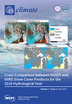
The VIIRS (Visible–Infrared Imaging Radiometer Suite) instrument on board the Suomi-NPP (National Polar-Orbiting Partnership) satellite aims to provide long-term continuity to several environmental data series including snow cover, initiated with MODIS (Moderate-Resolution Imaging Spectroradiometer). Two hundred and forty-four swath snow products from MODIS/Aqua (MYD10L2) and VIIRS EDR (Environmental Data Records) (VSCMO/binary) were intercompared using confusion matrices, comparison maps, and false color imagery. The assessment concluded that VIIRS and MODIS have a similar capacity to map snow cover. Moreover, VIIRS may potentially be able to more accurately map a snow cover area. Additionally, VIIRS can fulfill the aim of providing long-term continuity of satellite snow cover maps for the successful development of a climate data record. View this paper.
  • Issues are regarded as officially published after their release is announced to the table of contents alert mailing list.
  • You may sign up for e-mail alerts to receive table of contents of newly released issues.
  • PDF is the official format for papers published in both, html and pdf forms. To view the papers in pdf format, click on the "PDF Full-text" link, and use the free Adobe Reader to open them.
Order results
Result details
Section
Select all
Export citation of selected articles as:
17 pages, 4044 KiB  
Article
Characterization of Meteorological Droughts Occurrences in Côte d’Ivoire: Case of the Sassandra Watershed
by Natacha Santé, Yao Alexis N’Go, Gneneyougo Emile Soro, N’Diaye Hermann Meledje and Bi Tié Albert Goula
Climate 2019, 7(4), 60; https://0-doi-org.brum.beds.ac.uk/10.3390/cli7040060 - 20 Apr 2019
Cited by 10 | Viewed by 3947
Abstract
The Sassandra Basin, like most regions of Côte d’Ivoire, is increasingly affected by droughts that involve many environmental, social and economic impacts. This basin is full of several amenities such as hydroelectric dams, hydraulic and agricultural dams. There is also a strong agricultural [...] Read more.
The Sassandra Basin, like most regions of Côte d’Ivoire, is increasingly affected by droughts that involve many environmental, social and economic impacts. This basin is full of several amenities such as hydroelectric dams, hydraulic and agricultural dams. There is also a strong agricultural activity. In the context of climate change, it is essential to analyze the occurrence of droughts in order to propose mitigation or adaptation measures for water management. The methodological approach consisted initially in characterizing the dry sequences by the use of the SPI (Standardized Precipitation Index) and secondly in determining the probabilities of occurrence of successive dry years using by Markov chains 1 and 2. The results indicate that most remarkable droughts in terms of intensity and duration occurred after the 1970s. A comparison of Markov matrices 1 and 2 between the period considered 1953–2015 with the periods 1953–1970 and 1971–2015 shows a profound change in the distribution of droughts at the different station. Thus, the probability of having two successive dry years is greater over the period 1970–2015 and is accentuated to the Southern and Northern regions (probabilities ranging from 71% to 80%) of the basin. Over the 1970–2015 period, the probability of obtaining three successive dry years is significantly high in this watershed (between 20% and 70%). Full article
(This article belongs to the Special Issue Climate Variability and Change in the 21th Century)
Show Figures

Figure 1

18 pages, 3481 KiB  
Article
Impacts of Climate Change and Urban Expansion on Hydrologic Ecosystem Services in the Milwaukee River Basin
by Feng Pan and Woonsup Choi
Climate 2019, 7(4), 59; https://0-doi-org.brum.beds.ac.uk/10.3390/cli7040059 - 20 Apr 2019
Cited by 4 | Viewed by 4516
Abstract
Land use/land cover (LULC) and climate changes could affect water quantity and quality and thus hydrologic ecosystem services (ES). However, studies of these impacts on hydrologic ES are limited by the current methods and techniques. We attempted to find out how the LULC [...] Read more.
Land use/land cover (LULC) and climate changes could affect water quantity and quality and thus hydrologic ecosystem services (ES). However, studies of these impacts on hydrologic ES are limited by the current methods and techniques. We attempted to find out how the LULC and climate changes impact hydrologic ES at different temporal scales so that decision-makers can easily understand hydrologic ES variations for guiding management plans. In this study, we analyzed the impacts of LULC and climate changes on hydrologic ES in the Milwaukee River basin, USA with a conceptual modeling framework for hydrologic ES. The model framework was applied to a series of climate and urban expansion scenarios. Two hydrologic responses (streamflow and sediment) and three hydrologic ES (water provision index (WPI), flood regulation index (FRI), and sediment regulation index (SRI)) were calculated. Major findings include: (1) Climate change has much larger impacts than LULC at the monthly scale. For example, the impacts of climate change on streamflow were −6 to 9 m3/s whereas those of LULC change were −0.4 to 0.2 m3/s. Also, WPI (ranging from 0 to 1) changed between −0.16 and 0.07 with climate change but between −0.02 and −0.001 with LULC changes. (2) Compared to changes at the annual scale, the results show much larger variabilities as monthly time-series and mean monthly numbers. These findings suggest that the climate change weighs more than the realistic LULC change in term of impacts on hydrologic ES and those impacts can be identified with results at the monthly temporal scale. This approach with the framework and scenarios can better support management planning for decision-makers with detailed results and temporal precision. Full article
(This article belongs to the Special Issue Climate Change Resilience and Urban Sustainability)
Show Figures

Figure 1

12 pages, 2271 KiB  
Article
Application of Risk-Based, Adaptive Pathways to Climate Adaptation Planning for Public Conservation Areas in NSW, Australia
by Brent Jacobs, Louise Boronyak and Polly Mitchell
Climate 2019, 7(4), 58; https://0-doi-org.brum.beds.ac.uk/10.3390/cli7040058 - 19 Apr 2019
Cited by 13 | Viewed by 4569
Abstract
Globally, areas of high-quality wildlife habitat of significant environmental value are at risk of permanent damage from climate change. These areas represent social-ecological systems that will require increasing management intervention to maintain their biological and socio-cultural values. Managers of protected areas have begun [...] Read more.
Globally, areas of high-quality wildlife habitat of significant environmental value are at risk of permanent damage from climate change. These areas represent social-ecological systems that will require increasing management intervention to maintain their biological and socio-cultural values. Managers of protected areas have begun to recognize the inevitability of ecosystem change and the need to embrace dynamic approaches to intervention. However, significant uncertainty remains about the onset and severity of some impacts, which makes planning difficult. For Indigenous communities, there are intrinsic links between cultural heritage and the conservation of place and biodiversity that need to be better integrated in protected area planning and management. In New South Wales, Australia, management of public conservation reserves and national parks is the responsibility of a State government agency, the National Parks and Wildlife Service (NPWS). This paper describes the outcomes of a participatory planning process with NPWS staff to, firstly, identify the options available, the available ‘tool kit’, to manage biodiversity and cultural heritage in protected areas; secondly, explore how the selection of management actions from the ‘tool kit’ is associated with the level of climate risk to biodiversity or cultural heritage assets; and thirdly, to understand how the form of individual management actions might adapt to changes in climate risk. Combining these three elements into a series of risk-based, adaptive pathways for conservation of biodiversity and cultural heritage is a novel approach that is currently supporting place-based planning for public conservation areas. Incorporation of the trade-offs and synergies in seeking to effectively manage these discrete but related types of values and the implications for conservation practice are discussed. Full article
(This article belongs to the Special Issue Social-Ecological Systems, Climate and Global Change Impacts)
Show Figures

Figure 1

17 pages, 14456 KiB  
Article
Cross-Comparison between MODIS and VIIRS Snow Cover Products for the 2016 Hydrological Year
by Shubhechchha Thapa, Parveen K. Chhetri and Andrew G. Klein
Climate 2019, 7(4), 57; https://0-doi-org.brum.beds.ac.uk/10.3390/cli7040057 - 16 Apr 2019
Cited by 5 | Viewed by 3110
Abstract
The VIIRS (Visible Infrared Imaging Radiometer Suite) instrument on board the Suomi-NPP (National Polar-Orbiting Partnership) satellite aims to provide long-term continuity of several environmental data series including snow cover initiated with MODIS (Moderate Resolution Imaging Spectroradiometer). Although it is speculated that MODIS and [...] Read more.
The VIIRS (Visible Infrared Imaging Radiometer Suite) instrument on board the Suomi-NPP (National Polar-Orbiting Partnership) satellite aims to provide long-term continuity of several environmental data series including snow cover initiated with MODIS (Moderate Resolution Imaging Spectroradiometer). Although it is speculated that MODIS and VIIRS snow cover products may differ because of their differing spatial resolutions and spectral coverage, quantitative comparisons between their snow products are currently limited. Therefore, this study intercompares MODIS and VIIRS snow products for the 2016 Hydrological Year over the Midwestern United States and southern Canada. Two hundred and forty-four swath snow products from MODIS/Aqua (MYD10L2) and the VIIRS EDR (Environmental Data Records) (VSCMO/binary) were intercompared using confusion matrices, comparison maps and false color imagery. Thresholding the MODIS NDSI (Normalized Difference Snow Index) Snow Cover product at a snow cover fraction of 30% generated binary snow maps are most comparable to the NOAA VIIRS binary snow product. Overall agreement between MODIS and VIIRS was found to be approximately 98%. This exceeds the VIIRS accuracy requirements of 90% probability of correct typing. The agreement was highest during the winter but lower during late fall and spring. MODIS and VIIRS often mapped snow/no-snow transition zones as a cloud. The assessment of total snow and cloud pixels and comparison snow maps of MODIS and VIIRS indicate that VIIRS is mapping more snow cover and less cloud cover compared to MODIS. This is evidenced by the average area of snow in MYD10L2 and VSCMO being 5.72% and 11.43%, no-snow 26.65% and 28.67% and cloud 65.02% and 59.91%, respectively. While VIIRS and MODIS have a similar capacity to map snow cover, VIIRS has the potential to map snow cover area more accurately, for the successful development of climate data records. Full article
Show Figures

Figure 1

15 pages, 5096 KiB  
Article
Development of a Matrix Based Statistical Framework to Compute Weight for Composite Hazards, Vulnerability and Risk Assessments
by Rubaiya Kabir, Marin Akter, Dewan Sadia Karim, Anisul Haque, Munsur Rahman and Mohiuddin Sakib
Climate 2019, 7(4), 56; https://0-doi-org.brum.beds.ac.uk/10.3390/cli7040056 - 15 Apr 2019
Cited by 4 | Viewed by 4084
Abstract
Selection of relative weights for different indicators is a critical step during assessment of composite hazards, vulnerability, and risk. While assigning weight to an indicator, it is important to consider the influence of an individual indicator on a particular composite index. In general, [...] Read more.
Selection of relative weights for different indicators is a critical step during assessment of composite hazards, vulnerability, and risk. While assigning weight to an indicator, it is important to consider the influence of an individual indicator on a particular composite index. In general, the larger the weight of the indicator, the higher the importance of that indicator compared to other indicators. In this study, a new matrix based statistical framework (MSF) for weight assignment is developed that can be considered as the simplest and most accurate method for assigning weights for a large number of indicators. This method (MSF) is based on the valuation of the correlation matrix and Eigenvector associated with Eigenvalue. Relying on the inter build up methodology, MSF can fulfill some built-in gaps among other weightage methods. It can also directly give the ‘decision’ to select the relative weights that are found from the Eigenvector corresponding to the largest Eigenvalue. The new method is applied by assigning weights to 15 socio-economic indicators and assessed vulnerability and risk in the Bangladesh coast. While comparing with other weight methods, it is found that MSF gives the most acceptable physical explanation about the relative values of weights of indicators. In terms of accuracy, MSF is found to be most accurate compared to other weight methods. When large numbers of indicators are involved in an application, MSF is found to be relatively simple and easy to apply compared to other methods. Full article
Show Figures

Figure 1

27 pages, 876 KiB  
Article
Insurer Resilience in an Era of Climate Change and Extreme Weather: An Econometric Analysis
by L. James Valverde and Matteo Convertino
Climate 2019, 7(4), 55; https://0-doi-org.brum.beds.ac.uk/10.3390/cli7040055 - 08 Apr 2019
Cited by 6 | Viewed by 4941
Abstract
Having sustained, over the course of more than two decades, record-breaking natural catastrophe losses, American insurers and reinsurers are justifiably questioning the potential linkage between anthropogenic climate change and extreme weather. Here, we explore issues pertaining to this linkage, looking at both the [...] Read more.
Having sustained, over the course of more than two decades, record-breaking natural catastrophe losses, American insurers and reinsurers are justifiably questioning the potential linkage between anthropogenic climate change and extreme weather. Here, we explore issues pertaining to this linkage, looking at both the likely short-term implications for the insurance industry, as well as potential longer-term impacts on financial performance and corporate resilience. We begin our discussion with an overview of the implications that climate change is likely to have on the industry, especially as it relates to how catastrophic risks are construed, assessed, and managed. We then present the rudiments of an econometric analysis that explores the financial resilience of the property/casualty (P/C) industry in the face of both natural and man-made catastrophes. In this analysis, we explore the profitability consequences of several illustrative scenarios involving large-scale losses from extreme weather—specifically, a sequence of storms like those striking the U.S. in 2004—and a scenario that explores the prospect of a Katrina-scale storm in combination with a mass terror attack on the scale of 9/11. At systemic levels of aggregation, our analysis suggests a high degree of macro-resilience for the P/C industry. Moreover, we find that insurer resilience is higher for larger impacts, considering both the speed of recovery, as well as the inverse of the area under the unaffected system profile. We conclude with a summary of our findings and a closing commentary that explores the potential implications of these results for P/C insurers moving forward. Full article
(This article belongs to the Special Issue Climate Change Resilience and Urban Sustainability)
Show Figures

Graphical abstract

12 pages, 1775 KiB  
Article
Study of the Lower Stratospheric Temperature over the Arabian Peninsula
by Hosny M. Hasanean and Abdulhaleem H. Labban
Climate 2019, 7(4), 54; https://0-doi-org.brum.beds.ac.uk/10.3390/cli7040054 - 08 Apr 2019
Cited by 1 | Viewed by 4523
Abstract
Given the current concerns about climate change, particularly, the stratospheric temperature effect on climatic surface temperature, it is of fundamental importance to investigate the impact of the lower stratospheric temperature on regional climate. This paper examines the lower stratospheric temperature (LST) at 50 [...] Read more.
Given the current concerns about climate change, particularly, the stratospheric temperature effect on climatic surface temperature, it is of fundamental importance to investigate the impact of the lower stratospheric temperature on regional climate. This paper examines the lower stratospheric temperature (LST) at 50 hPa in the winter season and its relation to the surface air temperature (ST) over the Arabian Peninsula in the period 1951–2016. Generally, LST had an insignificant decreasing trend over the entire period, with a relatively high standard deviation of 1.3 °C. According to the coefficient of variability (COV), the fluctuation in the LST from year to year is relatively high, especially in the last reference period (1981–2010). An insignificant increasing (0.05 °C per year) trend through the period between 1951 and 1992 was observed, while an insignificant decreasing (−0.05 °C per year) trend was observed during the second period of 1993–2016. From the spectral analysis, the periodicity cycles of LST time series at periods of about 2.2, 2.54, and 13.2 years with respect to the 95% significance confidence level were found. LST may be influenced by quasi-biennial oscillation and the sunspot cycle. A strong relationship was found between LST and ST over the Arabian Peninsula. Full article
Show Figures

Figure 1

18 pages, 3916 KiB  
Article
A Case Study of Ozone Diurnal Variation in the Convective Boundary Layer in the Southeastern United States Using Multiple Observations and Large-Eddy Simulation
by Guanyu Huang, M.J. Newchurch, Shi Kuang and Huug G. Ouwersloot
Climate 2019, 7(4), 53; https://0-doi-org.brum.beds.ac.uk/10.3390/cli7040053 - 08 Apr 2019
Cited by 1 | Viewed by 3780
Abstract
We investigated the diurnal ozone variation on 6 September 2013 in a midsize urban environment using multiple in situ and remote-sensing measurements along with the Dutch atmospheric large-eddy simulation (DALES) model coupled with a chemical module and a dry deposition module that we [...] Read more.
We investigated the diurnal ozone variation on 6 September 2013 in a midsize urban environment using multiple in situ and remote-sensing measurements along with the Dutch atmospheric large-eddy simulation (DALES) model coupled with a chemical module and a dry deposition module that we added for this study. Our study area was Huntsville, Alabama, USA, a typical midsize city in the Southeastern United States. The ozone variation in the convective boundary layer (CBL) resulted mainly from local emissions and photochemical production stemming from weather conditions controlled by an anticyclonic system on that day. Local chemical production contributes approximately two thirds of the ozone enhancement in the CBL and, in this case, dynamical processes including ozone transport from the free troposphere (FT) to the CBL through the entrainment processes contributed the remainder. The numerical experiments performed by the large-eddy simulation (LES) model showed acceptable agreement with the TOLNet (The tropospheric ozone lidar network)/RO3QET (Rocket-city ozone quality evaluation in the troposphere) ozone DIAL (differential absorption lidar) observations. This study indicated the need for fine-scale, three-dimensional ozone observations with high temporal and spatial resolution for air quality studies at the urban scale and smaller. Full article
(This article belongs to the Special Issue Impact of Atmospheric Chemistry on Local Weather and Local Climate)
Show Figures

Figure 1

15 pages, 6680 KiB  
Article
Establishing Relationships between Drought Indices and Wildfire Danger Outputs: A Test Case for the California-Nevada Drought Early Warning System
by Daniel J. McEvoy, Mike Hobbins, Timothy J. Brown, Kristin VanderMolen, Tamara Wall, Justin L. Huntington and Mark Svoboda
Climate 2019, 7(4), 52; https://0-doi-org.brum.beds.ac.uk/10.3390/cli7040052 - 05 Apr 2019
Cited by 33 | Viewed by 9448
Abstract
Relationships between drought indices and fire danger outputs are examined to (1) incorporate fire risk information into the National Integrated Drought Information System California–Nevada Drought Early Warning System and (2) provide a baseline analysis for application of drought indices into a fire risk [...] Read more.
Relationships between drought indices and fire danger outputs are examined to (1) incorporate fire risk information into the National Integrated Drought Information System California–Nevada Drought Early Warning System and (2) provide a baseline analysis for application of drought indices into a fire risk management framework. We analyzed four drought indices that incorporate precipitation and evaporative demand (E0) and three fire indices that reflect fuel moisture and potential fire intensity. Seasonally averaged fire danger outputs were most strongly correlated to multi-scalar drought indices that use E0 (the Evaporative Demand Drought Index (EDDI) and the Standardized Precipitation Evapotranspiration Index (SPEI)) at approximately annual time scales that reflect buildup of antecedent drought conditions. Results indicate that EDDI and SPEI can inform seasonal fire potential outlooks at the beginning of summer. An E0 decomposition case study of conditions prior to the Tubbs Fire in Northern California indicate high E0 (97th percentile) driven predominantly by low humidity signaled increased fire potential several days before the start of the fire. Initial use of EDDI by fire management groups during summer and fall 2018 highlights several value-added applications, including seasonal fire potential outlooks, funding fire severity level requests, and assessing set-up conditions prior to large, explosive fire cases. Full article
Show Figures

Figure 1

20 pages, 5845 KiB  
Article
Modeling the Impact of Climate Change on Water Availability in the Zarrine River Basin and Inflow to the Boukan Dam, Iran
by Farzad Emami and Manfred Koch
Climate 2019, 7(4), 51; https://0-doi-org.brum.beds.ac.uk/10.3390/cli7040051 - 03 Apr 2019
Cited by 37 | Viewed by 5748
Abstract
The impacts of climate change on the water availability of Zarrine River Basin (ZRB), the headwater of Lake Urmia, in western Iran, with the Boukan Dam, are simulated under various climate scenarios up to year 2029, using the SWAT hydrological model. The latter [...] Read more.
The impacts of climate change on the water availability of Zarrine River Basin (ZRB), the headwater of Lake Urmia, in western Iran, with the Boukan Dam, are simulated under various climate scenarios up to year 2029, using the SWAT hydrological model. The latter is driven by meteorological variables predicted from MPI-ESM-LR-GCM (precipitation) and CanESM2-GCM (temperature) GCM models with RCP 2.6, RCP 4.5 and RCP 8.5 climate scenarios, and downscaled with Quantile Mapping (QM) bias-correction and SDSM, respectively. From two variants of QM employed, the Empirical-CDF-QM model decreased the biases of raw GCM- precipitation predictors particularly strongly. SWAT was then calibrated and validated with historical (1981–2011) ZR-streamflow, using the SWAT-CUP model. The subsequent SWAT-simulations for the future period 2012–2029 indicate that the predicted climate change for all RCPs will lead to a reduction of the inflow to Boukan Dam as well as of the overall water yield of ZRB, mainly due to a 23–35% future precipitation reduction, with a concomitant reduction of the groundwater baseflow to the main channel. Nevertheless, the future runoff-coefficient shows a 3%, 2% and 1% increase, as the −2% to −26% decrease of the surface runoff is overcompensated by the named precipitation decrease. In summary, based on these predictions, together with the expecting increase of demands due to the agricultural and other developments, the ZRB is likely to face a water shortage in the near future as the water yield will decrease by −17% to −39%, unless some adaptation plans are implemented for a better management of water resources. Full article
Show Figures

Figure 1

18 pages, 1624 KiB  
Article
Temperature Variability Differs in Urban Agroecosystems across Two Metropolitan Regions
by Monika H. Egerer, Brenda B. Lin and Dave Kendal
Climate 2019, 7(4), 50; https://0-doi-org.brum.beds.ac.uk/10.3390/cli7040050 - 03 Apr 2019
Cited by 8 | Viewed by 3682
Abstract
Climatically similar regions may experience different temperature extremes and weather patterns that warrant global comparisons of local microclimates. Urban agroecosystems are interesting sites to examine the multidimensional impacts of climate changes because they rely heavily on human intervention to maintain crop production under [...] Read more.
Climatically similar regions may experience different temperature extremes and weather patterns that warrant global comparisons of local microclimates. Urban agroecosystems are interesting sites to examine the multidimensional impacts of climate changes because they rely heavily on human intervention to maintain crop production under different and changing climate conditions. Here, we used urban community gardens across the California Central Coast metropolitan region, USA, and the Melbourne metropolitan region, Australia, to investigate how habitat-scale temperatures differ across climatically similar regions, and how people may be adapting their gardening behaviors to not only regional temperatures, but also to the local weather patterns around them. We show that, while annual means are very similar, there are strong interregional differences in temperature variability likely due to differences in the scale and scope of the temperature measurements, and regional topography. However, the plants growing within these systems are largely the same. The similarities may be due to gardeners’ capacities to adapt their gardening behaviors to reduce the adverse effects of local temperature variability on the productivity of their plot. Thus, gardens can serve as sites where people build their knowledge of local weather patterns and adaptive capacity to climate change and urban heat. Climate-focused studies in urban landscapes should consider how habitat-scale temperature variability is a background for interesting and meaningful social-ecological interactions. Full article
(This article belongs to the Special Issue Climate Change Resilience and Urban Sustainability)
Show Figures

Figure 1

14 pages, 1833 KiB  
Article
Climate Change Induced Salinization of Drinking Water Inlets along a Tidal Branch of the Rhine River: Impact Assessment and an Adaptive Strategy for Water Resources Management
by Matthijs van den Brink, Ymkje Huismans, Meinte Blaas and Gertjan Zwolsman
Climate 2019, 7(4), 49; https://0-doi-org.brum.beds.ac.uk/10.3390/cli7040049 - 02 Apr 2019
Cited by 11 | Viewed by 4747
Abstract
This study presents the results of an impact analysis of climate change on salinization and the long-term availability of drinking water resources along the river Lek, a tidal branch of the Rhine delta, and a potential mitigation measure. To this end, a one-dimensional [...] Read more.
This study presents the results of an impact analysis of climate change on salinization and the long-term availability of drinking water resources along the river Lek, a tidal branch of the Rhine delta, and a potential mitigation measure. To this end, a one-dimensional modelling approach was used that enabled studying 50 years of variation in discharge and tide in current and future climate. It was found that all locations are increasingly vulnerable to salt intrusion caused by the combination of sea level rise and decreasing river discharges. This affects both the yearly average chloride concentration and long duration exceedances of the threshold value of 150 mg/L. It was also found that diverting a higher fresh water discharge to the Lek of several tens of cubic meters per second reduces the risk of salinization at the upstream inlet locations. However, the increased influence of seawater intrusion on the drinking water inlets cannot be fully compensated for by this measure. The potential gain of the extra water for the drinking water inlets along the Lek has to be balanced against the impact of this measure on water levels and stream flows in other parts of the river system. Full article
(This article belongs to the Special Issue Impact of Climate-Change on Water Resources)
Show Figures

Figure 1

8 pages, 231 KiB  
Perspective
Climate-Smart Agriculture and Non-Agricultural Livelihood Transformation
by Jon Hellin and Eleanor Fisher
Climate 2019, 7(4), 48; https://0-doi-org.brum.beds.ac.uk/10.3390/cli7040048 - 31 Mar 2019
Cited by 28 | Viewed by 7304
Abstract
Agricultural researchers have developed a number of agricultural technologies and practices, known collectively as climate-smart agriculture (CSA), as part of climate change adaptation and mitigation efforts. Development practitioners invest in scaling these to have a wider impact. We use the example of the [...] Read more.
Agricultural researchers have developed a number of agricultural technologies and practices, known collectively as climate-smart agriculture (CSA), as part of climate change adaptation and mitigation efforts. Development practitioners invest in scaling these to have a wider impact. We use the example of the Western Highlands in Guatemala to illustrate how a focus on the number of farmers adopting CSA can foster a tendency to homogenize farmers, instead of recognizing differentiation within farming populations. Poverty is endemic in the Western Highlands, and inequitable land distribution means that farmers have, on average, access to 0.06 ha per person. For many farmers, agriculture per se does not represent a pathway out of poverty, and they are increasingly reliant on non-agricultural income sources. Ineffective targeting of CSA, hence, ignores small-scale farming households’ different capacities for livelihood transformation, which are linked to the opportunities and constraints afforded by different livelihood pathways, agricultural and non-agricultural. Climate-smart interventions will often require a broader and more radical agenda that includes supporting farm households’ ability to build non-agricultural-based livelihoods. Climate risk management options that include livelihood transformation of both agricultural and non-agricultural livelihoods will require concerted cross-disciplinary research and development that encompasses a broader set of disciplines than has tended to be the case to date within the context of CSA. Full article
(This article belongs to the Special Issue Sustainable Agriculture for Climate Change Adaptation)
14 pages, 278 KiB  
Article
Climate Change and Migration for Scandinavian Saami: A Review of Possible Impacts
by Ilan Kelman and Marius Warg Næss
Climate 2019, 7(4), 47; https://0-doi-org.brum.beds.ac.uk/10.3390/cli7040047 - 31 Mar 2019
Cited by 12 | Viewed by 10699
Abstract
Migration, especially of indigenous peoples, related to or influenced by climate change continues to gain increasing research and policy attention. Limited material remains for this topic for Scandinavia’s indigenous people, the Saami. This paper contributes to filling this gap by providing a review [...] Read more.
Migration, especially of indigenous peoples, related to or influenced by climate change continues to gain increasing research and policy attention. Limited material remains for this topic for Scandinavia’s indigenous people, the Saami. This paper contributes to filling this gap by providing a review for the Scandinavian Saami of the possible impacts of climate change on migration. Environmental influences, social influences, and a synthesis through livelihoods impacts, including for reindeer herding, is provided, followed by a discussion of Saami responses to climate change and migration mainly through a governance analysis. Overall, climate change’s impacts on the Saami do not necessarily entail abandoning their traditions, livelihoods, or homes. Instead, the most significant impact is likely to be migrants moving into the Arctic to pursue resource opportunities. Working collaboratively with the Saami, policies and practices are needed to ensure that indigenous interests are respected and that indigenous needs are met. Full article
(This article belongs to the Special Issue Social-Ecological Systems, Climate and Global Change Impacts)
18 pages, 2150 KiB  
Article
Information for Adaptation and Response to Flooding, Multi-Stakeholder Perspectives in Nigeria
by Jessica Lamond, Olalekan Adekola, Ibidun Adelekan, Bassey Eze and Fanan Ujoh
Climate 2019, 7(4), 46; https://0-doi-org.brum.beds.ac.uk/10.3390/cli7040046 - 29 Mar 2019
Cited by 13 | Viewed by 4859
Abstract
Provision of data and information for disaster risk reduction is increasingly important to enable resilience. However, the focus of provision in many African countries is limited to national scale risk assessment and meteorological data. The research aimed to consider the perspectives on availability [...] Read more.
Provision of data and information for disaster risk reduction is increasingly important to enable resilience. However, the focus of provision in many African countries is limited to national scale risk assessment and meteorological data. The research aimed to consider the perspectives on availability and access to information of different local urban actors that require reliable and specific information to make informed decisions. The research used workshop discussions and questionnaires to collect views from stakeholders in flood risk management in Nigerian cities about their current access to information and requirements. The results confirmed that stakeholders and communities agree in recognising the importance of climate information. Findings identified issues surrounding communication between agencies, government and technical experts. The role of the media and business in filling the vacuum left by state provision of information was further highlighted, demonstrating the potential for Private Public Partnerships in supporting adaptation and response to flooding. However, significant differences in access between sub-groups were also revealed such that some marginalised groups may be excluded from information. It follows that climate services, data and information provision need to be collaboratively designed in order to be more inclusive, meet user requirements and build community capacity. Full article
(This article belongs to the Special Issue Climate Services for Local Disaster Risk Reduction in Africa)
Show Figures

Figure 1

Previous Issue
Next Issue
Back to TopTop