Article

Climate Aridity and the Geographical Shift of Olive Trees in a Mediterranean Northern Region

by
Jesús Rodrigo-Comino
1,2,*,
Rosanna Salvia
3,
Giovanni Quaranta
3,
Pavel Cudlín
4,
Luca Salvati
5 and
Antonio Gimenez-Morera
6
1
Soil Erosion and Degradation Research Group, Department of Geography, Valencia University, Blasco Ibàñez 28, ES-46010 Valencia, Spain
2
Department of Physical Geography, Trier University, 54296 Trier, Germany
3
Mathematics, Computer Science and Economics Department, University of Basilicata, Viale dell’Ateneo Lucano, 85100 Potenza, Italy
4
Global Change Research Institute of the Czech Academy of Sciences, Lipová 1789/9, 370 05 České Budějovice, Czech Republic
5
Department of Economics and Law, University of Macerata, Via Armaroli 43, 62100 Macerata, Italy
6
Departamento de Economia y Ciencias Sociales, Universitat Politècnica de València, Cami de Vera S/N, 46022 Valencia, Spain
*
Author to whom correspondence should be addressed.
Submission received: 8 March 2021 / Revised: 6 April 2021 / Accepted: 10 April 2021 / Published: 12 April 2021
(This article belongs to the Special Issue Climate Change and Land)

Abstract

:
Climate change leverages landscape transformations and exerts variable pressure on natural environments and rural systems. Earlier studies outlined how Mediterranean Europe has become a global hotspot of climate warming and land use change. The present work assumes the olive tree, a typical Mediterranean crop, as a candidate bioclimatic indicator, delineating the latent impact of climate aridity on traditional cropping systems at the northern range of the biogeographical distribution of the olive tree. Since the olive tree follows a well-defined latitude gradient with a progressive decline in both frequency and density moving toward the north, we considered Italy as an appropriate case to investigate how climate change may (directly or indirectly) influence the spatial distribution of this crop. By adopting an exploratory approach grounded in the quali-quantitative analysis of official statistics, the present study investigates long-term changes over time in the spatial distribution of the olive tree surface area in Northern Italy, a region traditionally considered outside the ecological range of the species because of unsuitable climate conditions. Olive tree cultivated areas increased in Northern Italy, especially in flat districts and upland areas, while they decreased in Central and Southern Italy under optimal climate conditions, mostly because of land abandonment. The most intense expansion of the olive tree surface area in Italy was observed in the northern region between 1992 and 2000 and corresponded with the intensification of winter droughts during the late 1980s and the early 1990s and local warming since the mid-1980s. Assuming the intrinsic role of farmers in the expansion of the olive tree into the suboptimal land of Northern Italy, the empirical results of our study suggest how climate aridity and local warming may underlie the shift toward the north in the geographical range of the olive tree in the Mediterranean Basin. We finally discussed the implications of the olive range shift as a part of a possible landscape scenario for a more arid future.

1. Introduction

Climate change is a pivotal issue with well-known socioeconomic, cultural and political implications [1,2,3,4]. Earlier research foresees a potential impact on crop productivity, possibly altering the food and biomass available to animals and humans [5,6]. Several studies demonstrate that rising temperatures, declining rainfall and the concentration of precipitation over shorter periods lead to frequent and severe droughts, soil aridity, erosion and water shortages in both affluent countries and emerging economies, with negative consequences in the agricultural sector [7,8,9,10]. When combined with land mismanagement, climate change may drive land use transformations that impact vegetation cover and soil quality, fragmenting rural landscapes [11,12,13,14,15]. Given the continuous population increase characteristic of the Mediterranean region [16,17,18,19], sustainable land management strategies benefit from a more comprehensive assessment of long-term and short-term climate and land use dynamics, considering trends in natural and anthropogenic drivers together [20,21,22]. More specifically, a spatially explicit assessment of climate aridity trends may inform the development of efficient land management plans and apply useful nature-based solutions to achieve landscape, soil and environmental targets [23,24,25,26].
Climate changes have been documented worldwide [27,28] and are especially evident in the Mediterranean region, considered one of the global hotspots of climate variability in recent decades [29,30,31,32]. Earlier studies demonstrated significant variations in temperature and rainfall regimes (e.g., rising occurrence of seasonal events) and the increasing probability of extreme events as possible signals of climate change [33,34,35]. Although the relationship between climate change and land use change has been investigated extensively in some seminal works [36,37,38,39] and the most recent regional studies [40,41,42], relatively few studies analyzed the role of long-term climate variations in land use change at various spatiotemporal scales in the Mediterranean Basin [43,44,45,46]. A partial availability of (diachronic) regional and national land use maps [47,48] and incomplete data from long-term climate monitoring (e.g., weather stations) are some of the possible factors limiting research in this important field of study, especially in some world regions such as the Mediterranean Basin [49,50].
In this perspective, delineating other indicators aimed at evaluating the extent and spatial direction of climate change impacts and trends is imperative. Indicators based on documented (short-term) changes in the spatial distribution of plant or animal species contribute to answering this lack of basic information [51]. Considering the Mediterranean Basin as a climate change hotspot, the present study hypothesizes recent (human-driven) changes in the geographical distribution of likely the most typical Mediterranean crop—the olive tree—as an indirect response to climate change, confronting this assumption with empirical analysis of climate aridity and land use change at the northern (Alpine) range of the olive in Italy, a Southern European country representing the northern range for this crop species.
The olive tree is considered one of the most traditional elements of Mediterranean landscapes [52,53,54]. Braudel [55] evaluated the biogeographical distribution of the olive tree as the best criterion to delineate the biophysical (ecological) boundaries of the Mediterranean region. The olive tree has been cultivated since antiquity in the region, and olive groves form the most widespread land use across the whole basin [56]. At the same time, olive groves were (and are) also present in the geographical range as a wildwood type, either alone or, more frequently, in combination with natural vegetation (e.g., oak woods, maquis and garrigue, shrubland and extensive pastures under various management forms, including the traditional dehesa landscape in the Iberian Peninsula) and other mixed cultivated species of both tree and garden crops [57,58,59]. While olive tree production constitutes the economic base of almost all rural communities (from Portugal to Turkey and from Morocco to Israel [60]), relict environments grounded in the presence of wild olives are a key element of natural landscapes with biodiversity, aesthetic beauty and cultural amenities. Ecosystem services provided by olive groves contribute to soil protection from erosion and landslides, reducing wildfire risk and regulating water and nutrient cycling [61]. Especially in small islands and peripheral, inland districts, local communities devoted to agriculture largely depend on olive oil production [60,62,63].
Mediterranean rural landscapes with olive trees were demonstrated to experience intense climate variations, leading to changes in agronomic practices possibly adapted to warmer temperatures and altered rainfall patterns. In these areas, aridity and prolonged dry spells were signals of climate change [64,65], and short-haul crop migrations toward more suitable areas have been sometimes observed in connection with such changes [66,67,68]. As a result of rainfall decline with increased temperatures, especially during hot seasons, water scarcity has been increasingly affecting Mediterranean agriculture. In these contexts, the impact of global warming and non-efficient soil or water management on landscapes should be investigated more intensively.
The olive tree is one of the crops better adapted to summer droughts and hot climate regimes while being highly sensitive to snow and freezing during winter nights [57,58,59]. At the same time, extreme aridity can be harmful. Rossi et al. [69] stated that high olive production and low water input may indicate tightly interconnected food, energy and water resource systems. These findings suggest the importance of integrated solutions for more sustainable development of rural communities, from local to regional scales [70]. In such contexts, olive groves are experiencing deleterious impacts from drought [54,56,60,71], such as water-lacking diseases, photosynthetic performance impairment, oxidative stress and imbalances in plant nutrition [72]. In some cases, these issues were hypothesized to force farmers to adopt, in a sufficiently long time window, practical solutions to maintain as high of olive oil production as possible (e.g., rethinking the spatial localization of olive tree). In this sense, a specific measure could be installing olive trees in colder and wetter areas (e.g., in areas previously considered unsuitable or suboptimal for the species). However, to date, this assumption has been neither theoretically discussed nor empirically tested.
Benhadi-Marín et al. [73] and Martínez-Núñez et al. [74] combined olive trees with spiders and plant (pollen)-solitary bees to evaluate the (integrated) ecological (climate) and economic quality of agricultural management. Additionally, the indicators derived from the quantitative analysis of the crowns and rings of olive trees were quite extensively used for the estimation of soil erosion rates as a consequence of more intense rainfalls, an indirect signal of climate change [75,76]. These results also revealed high soil and water losses due to bare surfaces, intense tillage and intensive use of poor soils, which can be extended to a large part of the Mediterranean Basin [77,78,79]. However, the literature considering the olive tree as a proxy of climate change is relatively scarce and needs empirical confirmation with field studies and a more extensive bibliographic review.
Based on these premises, the present study explores the intrinsic relationship between climate change and the geographical shift of the olive tree toward the north in a Mediterranean country. First, a territorial analysis delineating at a sufficiently broad spatial scale, intensity, spatial distribution and temporal evolution of climate aridity (in turn connected with water scarcity in the surface soil layer) is provided. Second, the empirical results of this analysis are discussed for the possible impact on olive trees (i.e., assessing the human-driven expansion of this crop in areas previously considered suboptimal or unsuitable). With this perspective in mind, the geographical expansion of the olive tree is assumed to be a rational choice of territorial actors (e.g., farmers), maximizing income and optimizing land use in the context of climate change. Based on this assumption, olive tree expansion in unsuitable agricultural land may (at least indirectly) reflect changes in long-term climate regimes.
Italy seems to be a particularly appropriate area to test this assumption because of the largest latitudinal range in Southern Europe that corresponds with a broad heterogeneity in climate patterns, moving from arid to sub-humid wet regimes [80,81,82]. Prolonged dry spells became more and more recurrent in the country, involving previously non-affected areas such as Northern Italy. This region, including districts with intensive farming systems, has traditionally shown a wet, temperate alpine mixed climate, with mild and wet summers and temperate continental winters, having fog, snow and late freezing as basic characteristics of the cold season [83,84,85,86]. By hypothesizing the northern Mediterranean range of the olive tree moving progressively toward the north as a possible response to climate warming [87], our study provides empirical data contributing to delineating such a relationship in Northern Italy, a suboptimal region for olive cropping and one of the less suitable districts in Southern Europe because of the dominance of a temperate continental (non-Mediterranean) climate regime. Northern Italy—and more specifically, the area encompassing the Alps to the north and the Apennines to the south—includes seven administrative regions of the country (from west to east, Piedmont, Aosta Valley, Lombardy, Trentino Alto Adige, Veneto, Friuli Venezia Giulia and Emilia Romagna), displaying an evident (climatic) gap with the rest of Italy (Central and Southern regions), which are considered a traditional part of the geographical range of olive trees. Northern Italy experienced a mixed temperate continental regime less mitigated by the influence of the Adriatic Sea and more influenced by air masses originating from Alpine and Central European districts.
Combining official statistics from different data sources (Eurostat, the national statistical office of Italy (Istat) and other national sources of agricultural statistics) with land use databases, the continuous expansion of the olive tree in Northern Italy was investigated over a sufficiently long time horizon from official agricultural statistics (national censuses and sampling surveys) and land use maps. This analysis was carried out at multiple spatial levels (e.g., land use polygon, farm, district, elevation belt, province (NUTS-3 level—Nomenclature of Territorial Units for Statistics-) and administrative region (NUTS-2 level)) according to the sensitivity and precision of the adopted data source (from sampling surveys and national land use maps (less precise) to agricultural censuses and regional land use maps). The empirical analysis was integrated with a refined investigation of climate variations, focusing on the regionalized time series of a standard aridity index (the United Nations Environmental Program (UNEP) aridity index, considering rainfalls and reference evapotranspiration of soils and vegetation over a defined time frame) between 1951 and 2010. For the first time to our knowledge, the present study documents the shift toward the north of a traditional Mediterranean crop in Southern European countries. The results of this exploratory analysis delineate a temporal nexus between landscape change and climate variations, outlining the possible role of secondary data (official statistics) and diachronic land use mapping in connection with a narrative approach based on the literature review and field observations. A discussion on the relevance of climate aridity for the integrated analysis of land use changes in Mediterranean areas is finally presented, starting from the paradigmatic example of olive tree expansion in Northern Italy.

2. Materials and Methods
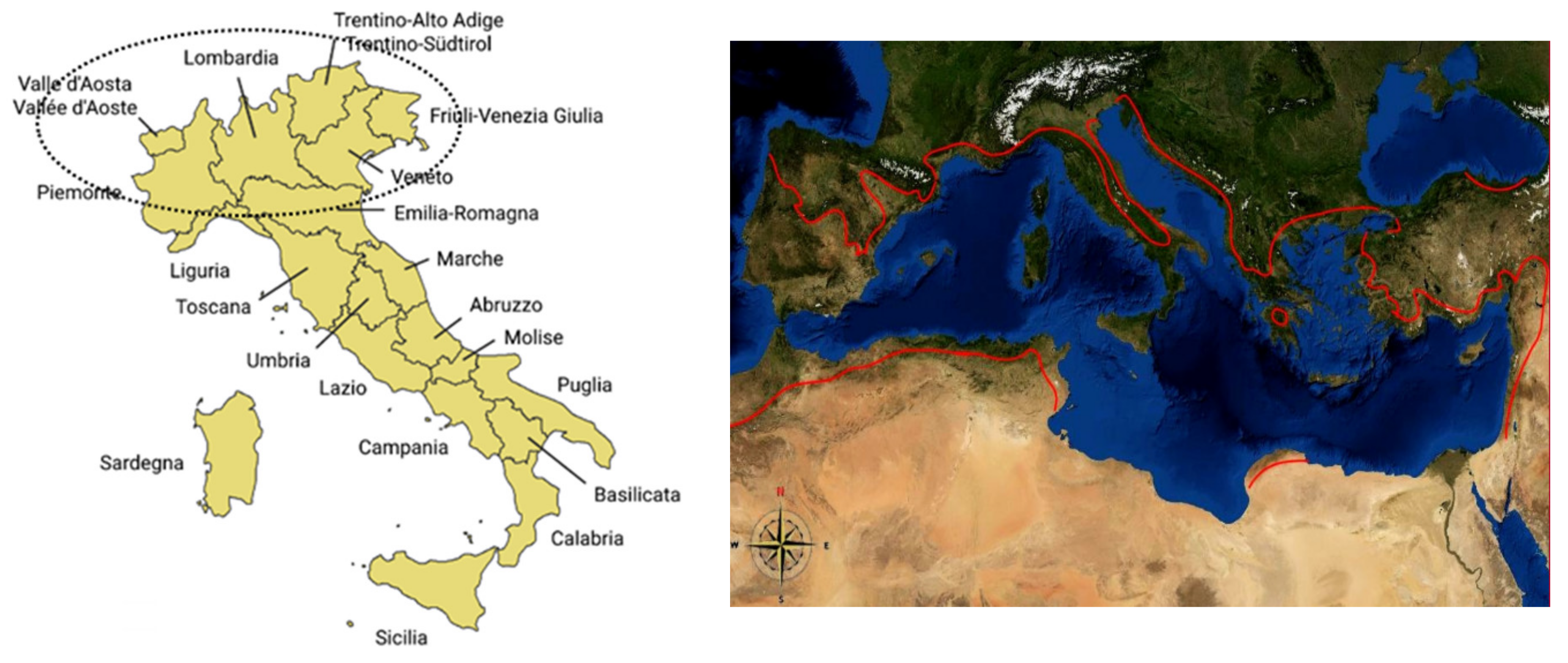
2.1. Study Area

Italy (301,330 km2) is divided into three macroregions with different socioeconomic and ecological features (North, Centre and South), twenty administrative regions (NUTS-2 level), more than one-hundred provinces (NUTS-3 level) and almost 8100 municipalities (NUTS-5 level). Additionally, the Italian National Institute of Statistics (Istat) identified three elevation belts delineating different land morphologies, settlement patterns and agricultural systems in Italy (lowlands (up to 100 m at sea level), uplands (between 100 m and 600 m at sea level) and mountainous districts). Our research focused on a study area that included seven administrative regions of Northern Italy (Aosta Valley, Piedmont, Lombardy, Veneto, Trentino Alto Adige, Friuli Venezia Giulia and Emilia Romagna) with the exclusion of Liguria, a Mediterranean area highly suitable for the olive tree (Figure 1). These seven regions represent the part of Italy above the northern limit of the olive tree (traditionally corresponding with the Apennine mountain chain, running northwest to southeast across Central and Southern Italy). Comparisons with the rest of Italy were proposed in this study when necessary.
The latitude, topography and proximity to the sea coast account for a considerable variation in climate, soils, vegetation, natural environments and rural landscapes. Average annual precipitation ranges between 350 mm in Sicily (Southern Italy) and 1500 mm in Friuli (Northeast Italy). Exceptionally diversified soil types and vegetation associations have been found across the country. After World War II, Italy underwent drastic land use changes due to urbanization, industrial concentration in flat areas, tourism growth and infrastructural development [88,89]. Crop intensification and land abandonment in marginal districts were (and still are) important symptoms of landscape transformation in Italy and likely in most regions of Mediterranean Europe [34,90]. Considering the proximity to the sea coast, our study further partitioned Italian land into five classes, overlapping elevation and distance from the sea layers (lowlands, coastal uplands, inland uplands, coastal mountains and inland mountains). We used this spatial partition as a reporting domain when computing elementary data from the national survey of agricultural land prices. Conversely, we used administrative regions (and provinces when possible) as a reporting domain when computing elementary data from national censuses of agriculture or annual agricultural surveys [91,92]. Finally, we used the native cartographic domain (i.e., spatial polygons corresponding with individual land use patches) when computing elementary data from land use maps [93].

2.2. Climate Data and Land Use Mapping

2.2.1. Climate Data Sources

The dataset used in this study included the month of precipitation and temperature time series from reference meteorological networks, including the Italian Air Force, the National Hydrological Service and the National Agrometeorological Service, for nearly 3000 gauging stations entirely covering the investigated area. The National Agrometeorological Data Base (BDAN) is a computerized archive, designed within the National Agricultural Information System (SIAN) of the Ministry of Agriculture, Food and Forestry Policies (MiPAAF). It collects basic observation data obtained from weather stations from different local and regional monitoring networks (Italian Council for Agricultural Research, Military Air Force, the former Hydrographic and Mareographic Service and the regional agrometeorological services). In addition to elementary data, BDAN includes several climate statistics and various agrometeorological indexes (www.politicheagricole.it, accessed on 6 April 2021).

2.2.2. Aridity Index

Increasingly considered as early warning indicators of climate change, aridity indexes, which are particularly appropriate to delineate the combined effect of rainfall reduction and local warming [64], were extensively used when evaluating land suitability to a given crop (including the olive tree) and the effectiveness of specific agronomic practices in various socioeconomic contexts [65,94]. The daily estimated evapotranspiration ET0 (mm day-1) was computed using the Penman–Monteith approach [30]. To describe long-term climate variations, we calculated the average rainfall and the aridity index (AI) by year [34]. This method is commonly used for estimating the gap between rainfall amounts and water demand. The formulation was adopted by United Nations Environment Program (UNEP; http://www.unep.org/, accessed on 6 April 2021), Food and Agriculture Organization (FAO; http://www.fao.org/, accessed on 6 April 2021) and United Nations Convention to Combat Desertification (UNCCD; http://www.unccd.int/main.php, accessed on 6 April 2021). Representing an accurate method of investigation and operational support to environmental assessment and land classification [95], the UNEP aridity index is defined as
AI = P/ET0,
where ET0 is the reference evapotranspiration and P is the total rainfalls, expressed with the same measurement unit (mm) and reported as annual averages [34]. The AI ranges between 0 and ∞, with higher values indicating wetter climate conditions. According to the standard AI classification [34], the investigated area was divided into four AI classes as follows: (1) AI < 0.50 for dry areas, (2) 0.50 < AI < 0.65 for dry, subhumid areas, (3) 0.65 < AI < 0.80 for subhumid areas and (4) AI > 0.80 for humid areas. The average annual rainfall and AI values were calculated separately for North, Central and Southern Italy along with four-time intervals (1951–1980, 1961–1990, 1971–2000 and 1981–2010).
To produce a homogeneous geographical coverage of the aridity index over a long period (1951–2010), kriging and co-kriging procedures were applied to the total annual precipitation and (minimum and maximum) temperature, respectively, producing raster maps at a 1 km spatial resolution using a data matrix of 32,640 values (60 years × 544 grid nodes). The resulting dataset was processed using ArcMap 10 (ESRI, Redwoods, USA) after synthesis of the temporal dimension obtained by calculating moving averages over a 30-year window. For each grid node, the mean AI values from 1951–1980, 1952–1981, 1953–1982, … and 1981–2010 were calculated. This allowed for compacting the data matrix for more efficient information management, filtering AI interannual variability at the same time.

2.3. Land Use Analysis

The latent shift toward the north in the spatial distribution of the olive tree was investigated in Italy, focusing on the seven administrative regions representative of a cold and wet area above the northern Italian limit (Figure 1, right). This area mostly coincided with the north and northeastern part of Italy, exposed to a continental or alpine climate regime with moderate (or negligible) Mediterranean influences. The area was located north of the historical biogeographical northern limit of the olive tree in Italy, which is the Apennine mountain chain moving from Liguria to Emilia Romagna. However, a restricted area close to Garda Lake (the biggest lake in Northern Italy, in between Veneto and Lombardy) specializes in local olive production because of the exceptionally mild climate observed in this district.
Three official data sources were adopted to assess the geographical expansion of the olive tree in Northern Italy at different spatiotemporal scales: (1) agricultural censuses (Istat) carried out in 1982, 1990, 2000 and 2010, as well as the sampling survey of farm structures (2016), producing data on cultivated land at the regional scale; (2) the annual survey of land prices (between 1992 and 2018) undertaken by the Italian National Institute of Agricultural Economics (INEA), now the Italian Council for Agricultural Research and Economics (CREA), providing data on crop surfaces at a subregional scale; (3) land use maps, including large-scale (1:100,000) CORINE Land Cover (1960 and 2018) databases; and (4) smaller scale (1:10,000) regional cartography focusing on Emilia Romagna (1976, 1994, 2003, 2008 and 2017). This region was more intensively studied because of the specific geographical location and intrinsic climate characteristics (at the interface between the Mediterranean and continental climate regimes). All these data sources include extensive (and comparable) information on the geographical extent of olive tree-cultivated areas. Olive tree-cultivated areas by administrative region (census data) and elevation belt (survey data) were quantified at different years based on secondary data availability.

3. Results

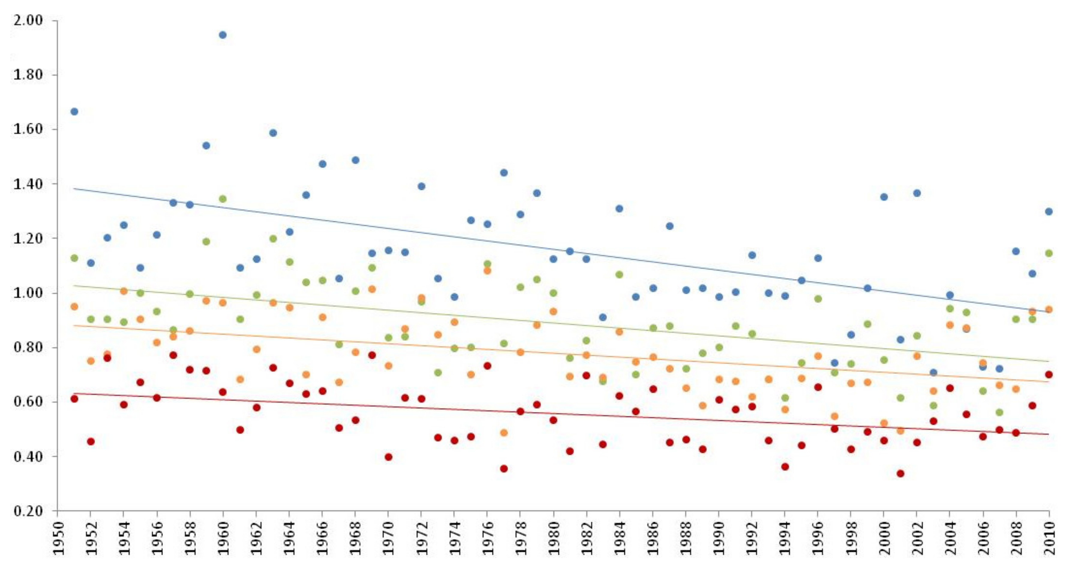
3.1. Trends in Climate Aridity in Italy (1951–2010)

In Italy, the Northern macroregion displayed the highest rainfall amounts on average (1019 mm between 1951 and 1980). Only 974 mm were recorded in Central Italy, and an even smaller amount was found in Southern Italy (735 mm). Thirty years later (1981–2010), rainfall amounts declined progressively in Northern Italy (865 mm) as well as in Central (833 mm) and Southern Italy (658 mm). However, a percent decline between the two-time intervals was more intense in Northern and Central Italy (−0.56% and −0.54%, respectively) than in Southern Italy (−0.39%). The largest decrease in total precipitation was recorded in the 2000s, with 2003, 2005, 2006 and 2007 being classified as very dry years all over the study period. The aridity index showed a similar pattern, decreasing by 0.68% per year in Northern Italy compared with −0.60% and −0.46% in Central and Southern Italy, respectively. Analysis of trends over time in the aridity index (Figure 2) revealed the continuous shift toward climate aridity in Northern Italy, a traditionally wet region (IA = 1.42 between 1951 and 1980) becoming progressively drier (IA = 1.16 between 1981 and 2010). A less intense shift toward aridity was observed in Central Italy, with even weaker signals of aridification from Southern Italy and the two major islands, although these contexts were already classified as dry subhumid (IA = 0.72 and 0.63 during 1951–1980 and 1981–2010, respectively).
A regional analysis of climate aridity in Northern Italy (Table 1) revealed a particularly heterogeneous territorial context over time. All administrative regions in Northern Italy experienced a marked reduction in the average aridity index. Emilia Romagna was classified as the driest area in Northern Italy, showing an aridity index structurally below 1 and declining rapidly over time (0.96 and 0.81 in 1951–1980 and 1981–2010, respectively). Although being formally classified as non-arid, the average climate regime in Emilia Romagna has rapidly approached the 0.75 thresholds, and many parts of the region have already been classified as dry subhumid, experiencing a minimum IA value of 0.54. The Veneto region also showed relatively low values of the aridity index in both time intervals, decreasing from 1.18 (1951–1980) to 0.98 (1981–2010). Lombardy and Piedmont were the other two regions having aridity values close to one in the more recent time interval. Taken together, these results indicate how Northern Italy as a whole is slowly converging toward a drying climate regime similar to those observed in Central and Southern Italy, both regions included in the biogeographical range of the olive tree. Similar to Central and Southern Italy, relatively dry regimes were observed on a regional scale in Northern Italy, especially in flat districts and the gentle hilly areas of Emilia Romagna and Veneto, indicating local contexts with mild winters and sunny springs. These conditions appear to be potentially appropriate for olive tree growth all over the year.

3.2. Land Use Changes

The surface area of olive crops expanded in Northern Italy in respect with other Italian regions, where this crop was found to be stable or mostly regressing (Table 2). In 1992, olive trees extended about 6000 hectares in Northern Italy, doubling their surface area in both 2009 and 2018 (around 12,000 hectares). The olive tree surface area increased at all elevation belts, although the most rapid expansion was found in lowlands. Relatively large increases were also observed in both inland uplands and mountainous districts. The olive tree surface area in the uplands close to the seacoast was more stable over time. Although the expansion of olive trees involved relatively limited areas (59 km2 in 1992 and 115 km2 in 2018) in respect to the total surface of the study area, the increase of such comparatively small surfaces represents a non-negligible phenomenon for a study area originally classified as non-suitable to the olive tree. Moreover, olive tree expansion was observed not only in flat districts with a milder climate during winter, but also in mountainous areas. Such results may reflect a latent shift toward the north in the geographical range of this species, possibly mediated by economic agents (farmers) and supported by a milder climate regime.
Considering the administrative regions in Northern Italy, the olive tree surface area increased systematically over time (Table 3), especially in Lombardy, Veneto, Emilia Romagna and Friuli Venezia Giulia. These regions constitute the eastern side of the Po Plain. More discontinuous data were found in Piedmont and Aosta Valley, both located on the western side of Northern Italy. The small extension of olive trees in Trentino Alto Adige mostly reflects a local expansion process along the Garda Lake, a small district with particularly suitable microclimate conditions for olive trees. Veneto and Emilia Romagna were the two regions with the largest surface of olive trees in Northern Italy.
A disaggregated analysis at the province scale provided a refined evaluation of olive tree spreading in Northern Italy in recent decades (Table 4). The number of provinces with olive trees increased from 13 (1982) to 43 (2010). Olive trees expanded more in five provinces (Verona, Brescia and Vicenza, close to Garda Lake district, as well as Forlì-Cesena and Rimini, close to the Adriatic Sea). However, a less rapid expansion was also observed in other provinces far away from local contexts with supposedly more favorable micro-climatic conditions, such as the Adriatic Sea coast or the Garda Lake. These cases included Alessandria, Treviso, Padua, Udine, Bologna and Ravenna. These territories have suboptimal (or completely unsuitable) climatic conditions for olive cropping.
Using high-resolution land use maps (1:10,000), a specific focus was carried out for Emilia Romagna, the closest region to the Appennine mountain chain (i.e., the northern limit of the olive tree in Italy) and the area experiencing the most intense climate variations toward aridity in Northern Italy. These maps delineated olive tree patches with homogenous criteria over time. A total of 766 hectares were observed in 1976, increasing to 1993 hectares in 1994, 2056 hectares in 2003, 2155 ha in 2008 and 4166 ha in 2017. In 1994, a total of 186 landscape patches classified as olive trees were found in Emilia Romagna, with a mean size of 10.7 ha and a maximum size of 107 ha. In 2017, a total of 3530 landscape patches classified as olive trees were identified with a mean size of 1.2 ha and a maximum size of 79.3 ha, indicating processes of crop expansion and fragmentation at the same time. The olive tree was cultivated under relatively small patches, likely more diffused across family (smaller) farms. These results indirectly confirmed that an increasing number of farmers evaluated the olive tree as a suitable crop for farming in Emilia Romagna, possibly as a response to drier microclimatic conditions.

4. Discussion

Global warming, together with economic development and demographic growth, have led to important landscape transformations over large areas of the Earth, including some Mediterranean regions in Europe [70,73,76,77]. After experiencing recurrent droughts with a generalized increase in climatic aridity, the Mediterranean Basin was considered one of the most important hotspots for desertification risk in Europe [96,97]. It has been widely demonstrated how the increasing level of ecological vulnerability in Southern Europe was associated with long-term ecological dynamics (e.g., soil and climate aridity), together with socioeconomic processes triggering important modifications in the rural landscape [98,99]. These negative conditions can be accentuated by unsustainable land management, especially in ecologically fragile areas [100,101]. Analysis of complex territorial dynamics involving socioeconomic and environmental issues suggests the adoption of multidisciplinary approaches aimed at delineating the intimate relationship between the “demo-economic” dimension and the ”ecological” sphere, especially in rural areas with “high social density” and intense feedbacks between natural environments and human components [102,103,104].
In these regards, our approach provides some empirical evidence of the progressive shift toward the north of olive trees in Italy, possibly driven by farmers’ rational choices. This latent process, more evident in recent decades, paralleled a generalized increase of climate aridity, reflecting drier soils and microclimatic conditions oriented toward summer droughts and milder winters (i.e., with no snow and air temperatures systematically above 0 °C overnight). These conditions, particularly frequent in the last two decades, make a large part of Northern Italy suitable to olive cropping, contrary to what was observed three or four decades ago [54]. Climate warming and aridification could be important reason supporting the recent, farmer-driven expansion of olive trees in the area. Earlier studies have identified Northern Italy as a (regional) climate hotspot in Europe, as far as water shortage, soil aridity and land degradation are concerned [105]. As a crop typically adapted to poor soils and a dry Mediterranean climate, olive trees have been increasingly cultivated in marginal districts of Northern Italy that were considered completely unsuitable (mainly because of the high probability of snow, ice and frost during winter) up to three decades ago. The choice of farmers to adopt an olive tree as a yield crop in marginal farms (especially in the Emilia Romagna and Veneto regions) can be assumed to be a rational strategy, adapting to drier climate conditions. In such contexts, a rustic crop like the olive tree, more likely to survive in the present climate conditions than a few years ago, may also give value to marginal soils, which are more exposed to prolonged droughts.
Olive tree surface areas increased in both the lowlands and uplands over the last two decades. Notably, despite intense competition for land with other crops (and other land use), olive trees also expanded in fertile (high-income) agricultural districts along the Po River, likely benefiting from the milder temperatures during winter and drier conditions during spring and summer. It cannot be excluded that a moderate increase in the economic demand for olive oil has driven the local expansion of the olive tree in Northern Italy. However, this hypothesis seems implausible, considering that a strong decline of the olive tree was documented for decades in Central and Southern Italy [106,107], where (1) optimal conditions for olive cropping were available, (2) high-quality oils were produced, (3) farming costs were generally lower, and (4) transportation costs to Northern Italy were relatively small. Olive oil from Central and Southern Italy was also extensively and traditionally used in Northern Italy because of the massive presence of internal migrants coming from the south [108]. Based on these considerations, a simple question may arise from the results of this study: did the climate make people change, or did people change vegetations in response to climate change? Although empirical findings indicate how the latter assumption seems to be more adherent to the olive tree case in Northern Italy, a theoretical discussion about environmental determinism against cultural baggage (e.g., [109]) can also contribute to shedding light on these intriguing issues.
Based primarily on farmers’ rational choices, the olive tree spreading toward the north was temporally correlated with the progressive warming and aridification observed at the local scale in Northern Italy. These signals include lower amounts of precipitation (especially during winter) and higher temperatures over winter nights, a complete absence of winter fog in lowlands and less snow in the uplands, typical climatic characteristics of Northern Italian winters up to the late 1980s. Although the present study was not intended to delineate a causal relationship between climate and land use changes, olive tree expansion in Northern Italy was accompanied by early signs of climate aridity, long-term soil aridification and more frequent dry spells. In this perspective, olive tree expansion is assumed as a possible adaptation strategy of farmers (and especially small farmers) to climate change and more intense water shortages in Northern Italy [110]. Using the olive tree as a yield crop means significant savings in water requirements and irrigation costs, needing very elementary agronomic practices (small-cost fertilizers and chemicals) in the environmental contexts dominant in the flat and hilly districts of Northern Italy. As a matter of fact, increases in the surface area of the olive tree may indicate a progressive preference of Northern Italian farmers toward (originally unsuitable) low-income and rustic crops with very low costs, irrespective of elevation and microclimatic conditions. This phenomenon seems to be even more important, considering that land in Northern Italy, and especially along the Po Plain, is the most fertile in the country, supporting high-income crops (orchards, cereals and horticulture) in specialized districts with intensive farming systems.
The introduction (and ecological adaptation) of a particularly rustic and medium-low income crop such as the olive tree represents a landscape transformation that can be considered an early warning for progressive climate aridity. In this direction, further efforts are needed to clarify the cost–benefit relationship of introducing a rustic, low-income crop like the olive tree in the potentially fertile and high value-added land of Northern Italy. Assessing short-term trends in olive tree-cultivated areas is also appropriate in light of the sustainable use of water and soil in areas exposed to rising aridity [111,112]. The olive tree requirements in soil fertility and water amounts are rather modest and adapted to dry (local) conditions, instead of the large majority of crops in the area [113,114,115]. Olive trees thus represent an intrinsic, win-win adaptation to droughts because of the intimately low water requirements in comparison with traditional high-income crops in Northern Italy (e.g., horticulture, maize and orchards).
Taken together, the results of this study support the assumptions delineated in an earlier study based on climate modelling [116] and justify the importance of empirical studies testing together with the outcomes of general circulation models and landscape scenarios. Our study finally delineates landscape transformations in the flat and hilly lands of Northern Italy that have specific impacts on local socioeconomic systems and require continuous monitoring from both ecological and social perspectives [117]. Expansion of the olive tree in Northern Italy is definitely important, since tree crops, strongly contributing to a healthy rural landscape, may preserve key ecosystem functions at the core of social transition and political debate [118,119]. Short- and medium-term forecasts of regional climate trends in the Mediterranean Basin (e.g., aridity, prolonged dry spells and water scarcity) are in line with a further (farmer-mediated) expansion of the olive tree in Northern Italy [120,121].
Spreading toward the north of the olive tree in Italy reveals how dynamic the latent transformations in rural landscapes are, where farmers responding to a changing climate are the main economic agents of change. In such a context, regional planning should better cope with the feedback relationship between climate change and land use transformations at the local scale, assuming agriculture is more effectively governed by multilevel and multidisciplinary policies that incorporate short-term and long-term targets together [122,123]. The results of the analysis of climate and land use trends in a representative case study, like Northern Italy, outlined a dynamic picture of the (evolving) environmental conditions that determine a new balance between regional climate regimes, landscape transformations and the local communities characterizing rural spaces.

5. Conclusions

The degradation of natural environments and physical depletion of the (forest tree crop) rural matrix is a major issue in any environmental policy. Conservation of extensive rural systems is a pillar that informs strategies of all the conventions of the United Nations (climate change, desertification and biodiversity). This issue also demonstrates the role of extensive farming systems in developing zero net land degradation goals in a range of socioeconomic contexts around the world, in advanced economies and emerging countries. In the Mediterranean region, the olive tree is one of the most widespread components of extensive rural systems. Here, the role of the olive tree as a powerful mediator of socioecological services is highlighted in all strategies of environmental interest (soil, water and air directives from the European Union, as well as the European Landscape Convention). With this perspective in mind, our study goes beyond traditional monitoring approaches, providing an integrated, exploratory climate and land use framework that may contribute to delineating a future way to achieve sustainable management of rural landscapes exposed to climate change. Rustic crops such as the olive tree are appropriate to preserve environmental quality, providing characteristic ecosystem services and economically viable productions and being more adapted to a changing climate (e.g., aridity) than other crops. In this perspective, specific landscape modifications can be seen as a (formal or informal) response to climate change, influencing the effectiveness of environmental policies, whose representativeness, in turn, depends on the quality of regional strategies for rural development and land resource conservation.

Author Contributions

L.S. and P.C. conceived and designed the research; J.R.-C. and A.G.-M. performed data analysis and bibliographic review; G.Q. and R.S. contributed materials and analysis tools and revised the paper; L.S., R.S. and G.Q. wrote the paper; P.C., J.R.-C. and A.G.-M. revised the paper. All authors have read and agreed to the published version of the manuscript.

Funding

This research received no external funding.

Institutional Review Board Statement

Not applicable.

Informed Consent Statement

Not applicable.

Data Availability Statement

Data are available from the authors upon reasonable request.

Conflicts of Interest

The authors declare no conflict of interest.

References

  1. Land Degradation in Mediterranean Environments of the World: Nature and Entent, Causes and Solutions; Conacher, A.J.; Sala, M. (Eds.) John Wiley and Sons Ltd.: Chichester, UK; New York, NY, USA, 1998; ISBN 978-0-471-96317-2. [Google Scholar]
  2. Sivakumar, M.V.K. Interactions between Climate and Desertification. Agric. For. Meteorol. 2007, 142, 143–155. [Google Scholar] [CrossRef]
  3. Helldén, U.; Tottrup, C. Regional Desertification: A Global Synthesis. Glob. Planet. Chang. 2008, 64, 169–176. [Google Scholar] [CrossRef]
  4. Barnett, J. Global Environmental Change II: Political Economies of Vulnerability to Climate Change. Prog. Hum. Geogr. 2020, 44, 1172–1184. [Google Scholar] [CrossRef]
  5. Wheeler, T.; von Braun, J. Climate Change Impacts on Global Food Security. Science 2013, 341, 508–513. [Google Scholar] [CrossRef] [PubMed]
  6. Grossi, G.; Goglio, P.; Vitali, A.; Williams, A.G. Livestock and Climate Change: Impact of Livestock on Climate and Mitigation Strategies. Anim. Front. 2019, 9, 69–76. [Google Scholar] [CrossRef] [PubMed] [Green Version]
  7. Romm, J. The next Dust Bowl. Nature 2011, 478, 450–451. [Google Scholar] [CrossRef]
  8. Bárcena-Martín, E.; Molina, J.; Hueso, P.; Ruiz-Sinoga, J.D. A Class of Indices and a Graphical Tool to Monitor Temperature Anomalies. Air Soil Water Res. 2020, 13. [Google Scholar] [CrossRef]
  9. Araya, A.; Stroosnijder, L. Assessing Drought Risk and Irrigation Need in Northern Ethiopia. Agric. For. Meteorol. 2011, 151, 425–436. [Google Scholar] [CrossRef]
  10. Rodrigo-Comino, J.; Terol, E.; Mora, G.; Gimenez-Morera, A.; Cerdà, A. Vicia Sativa Roth. Can Reduce Soil and Water Losses in Recently Planted Vineyards (Vitis vinifera L.). Earth Syst. Environ. 2020. [Google Scholar] [CrossRef]
  11. Kosmas, C.; Gerontidis, S.; Marathianou, M. The Effect of Land Use Change on Soils and Vegetation over Various Lithological Formations on Lesvos (Greece). Catena 2000, 40, 51–68. [Google Scholar] [CrossRef]
  12. Marathianou, M.; Kosmas, C.; Gerontidis, S.; Detsis, V. Land-Use Evolution and Degradation in Lesvos (Greece): A Historical Approach. Land Degrad. Dev. 2000, 11, 63–73. [Google Scholar] [CrossRef]
  13. Maracchi, G.; Sirotenko, O.; Bindi, M. Impacts of present and future climate variability on agriculture and forestry in the temperate regions: Europe. In Increasing Climate Variability and Change: Reducing the Vulnerability of Agriculture and Forestry; Salinger, J., Sivakumar, M.V.K., Motha, R.P., Eds.; Springer: Dordrecht, The Netherlands, 2005; pp. 117–135. ISBN 978-1-4020-4166-2. [Google Scholar]
  14. Moriondo, M.; Good, P.; Durao, R.; Bindi, M.; Giannakopoulos, C.; Corte-Real, J. Potential Impact of Climate Change on Fire Risk in the Mediterranean Area. Clim. Res. 2006, 31, 85–95. [Google Scholar] [CrossRef]
  15. Akter, T.; Quevauviller, P.; Eisenreich, S.J.; Vaes, G. Impacts of Climate and Land Use Changes on Flood Risk Management for the Schijn River, Belgium. Environ. Sci. Policy 2018, 89, 163–175. [Google Scholar] [CrossRef]
  16. Antrop, M. Changing Patterns in the Urbanized Countryside of Western Europe. Landsc. Ecol. 2000, 15, 257–270. [Google Scholar] [CrossRef]
  17. Antrop, M. Landscape Change and the Urbanization Process in Europe. Landsc. Urban Plan. 2004, 67, 9–26. [Google Scholar] [CrossRef]
  18. Latorre, J.G.; Garcı́a-Latorre, J.; Sanchez-Picón, A. Dealing with Aridity: Socio-Economic Structures and Environmental Changes in an Arid Mediterranean Region. Land Use Policy 2001, 18, 53–64. [Google Scholar] [CrossRef]
  19. Salvati, L.; Sabbi, A. Exploring Long-Term Land Cover Changes in an Urban Region of Southern Europe. Int. J. Sustain. Dev. World Ecol. 2011, 18, 273–282. [Google Scholar] [CrossRef]
  20. Tanrivermis, H. Agricultural Land Use Change and Sustainable Use of Land Resources in the Mediterranean Region of Turkey. J. Arid Environ. 2003, 54, 553–564. [Google Scholar] [CrossRef]
  21. Solecki, W.D.; Oliveri, C. Downscaling Climate Change Scenarios in an Urban Land Use Change Model. J. Environ. Manag. 2004, 72, 105–115. [Google Scholar] [CrossRef] [PubMed]
  22. Briassoulis, H. Combating Land Degradation and Desertification: The Land-Use Planning Quandary. Land 2019, 8, 27. [Google Scholar] [CrossRef] [Green Version]
  23. Visser, S.; Keesstra, S.; Maas, G.; de Cleen, M.; Molenaar, C. Soil as a Basis to Create Enabling Conditions for Transitions Towards Sustainable Land Management as a Key to Achieve the SDGs by 2030. Sustainability 2019, 11, 6792. [Google Scholar] [CrossRef] [Green Version]
  24. Rodrigo-Comino, J.; Giménez-Morera, A.; Panagos, P.; Pourghasemi, H.R.; Pulido, M.; Cerdà, A. The Potential of Straw Mulch as a Nature-Based Solution for Soil Erosion in Olive Plantation Treated with Glyphosate: A Biophysical and Socioeconomic Assessment. Land Degrad. Dev. 2020, 31, 1877–1889. [Google Scholar] [CrossRef]
  25. Maes, J.; Jacobs, S. Nature-Based Solutions for Europe’s Sustainable Development. Conserv. Lett. 2017, 10, 121–124. [Google Scholar] [CrossRef] [Green Version]
  26. Baumber, A.; Berry, E.; Metternicht, G. Synergies between Land Degradation Neutrality Goals and Existing Market-Based Instruments. Environ. Sci. Policy 2019, 94, 174–181. [Google Scholar] [CrossRef]
  27. Porter, J.R.; Howden, M.; Smith, P. Considering Agriculture in IPCC Assessments. Nat. Clim. Chang. 2017, 7, 680–683. [Google Scholar] [CrossRef] [Green Version]
  28. Beck, S.; Mahony, M. The IPCC and the New Map of Science and Politics. Wires Clim. Chang. 2018, 9, e547. [Google Scholar] [CrossRef] [Green Version]
  29. Diffenbaugh, N.; Pal, J.; Giorgi, F.; Gao, X. Heat Stress Intensification in the Mediterranean Climate Change Hotspot. Geophys. Res. Lett. 2007, 34, 1–6. [Google Scholar] [CrossRef] [Green Version]
  30. Giorgi, F.; Lionello, P. Climate Change Projections for the Mediterranean Region. Glob. Planet. Chang. 2008, 63, 90–104. [Google Scholar] [CrossRef]
  31. Pasqui, M.; Di Giuseppe, E. Climate Change, Future Warming, and Adaptation in Europe. Anim. Front. 2019, 9, 6–11. [Google Scholar] [CrossRef] [Green Version]
  32. Pausas, J.G.; Millán, M.M. Greening and Browning in a Climate Change Hotspot: The Mediterranean Basin. BioScience 2019, 69, 143–151. [Google Scholar] [CrossRef] [Green Version]
  33. Brunetti, M.; Maugeri, M.; Nanni, T.; Navarra, A. Droughts and Extreme Events in Regional Daily Italian Precipitation Series. Int. J. Climatol. 2002, 22, 543–558. [Google Scholar] [CrossRef]
  34. Salvati, L.; Petitta, M.; Ceccarelli, T.; Perini, L.; Battista, F.D.; Scarascia, M.E.V. Italy’s Renewable Water Resources as Estimated on the Basis of the Monthly Water Balance. Irrig. Drain. 2008, 57, 507–515. [Google Scholar] [CrossRef]
  35. Martínez-Valderrama, J.; Ibáñez, J.; Del Barrio, G.; Sanjuán, M.E.; Alcalá, F.J.; Martínez-Vicente, S.; Ruiz, A.; Puigdefábregas, J. Present and Future of Desertification in Spain: Implementation of a Surveillance System to Prevent Land Degradation. Sci. Total Environ. 2016, 563–564, 169–178. [Google Scholar] [CrossRef] [PubMed]
  36. Dale, V.H. The Relationship Between Land-Use Change and Climate Change. Ecol. Appl. 1997, 7, 753–769. [Google Scholar] [CrossRef]
  37. Pielke, R.A. Land Use and Climate Change. Science 2005, 310, 1625–1626. [Google Scholar] [CrossRef] [PubMed] [Green Version]
  38. Rounsevell, M.D.A.; Reay, D.S. Land Use and Climate Change in the UK. Land Use Policy 2009, 26, S160–S169. [Google Scholar] [CrossRef]
  39. Song, X.-P.; Hansen, M.C.; Stehman, S.V.; Potapov, P.V.; Tyukavina, A.; Vermote, E.F.; Townshend, J.R. Global Land Change from 1982 to 2016. Nature 2018, 560, 639–643. [Google Scholar] [CrossRef]
  40. Asner, G.P.; Loarie, S.R.; Heyder, U. Combined Effects of Climate and Land-Use Change on the Future of Humid Tropical Forests. Conserv. Lett. 2010, 3, 395–403. [Google Scholar] [CrossRef]
  41. Popp, A.; Humpenöder, F.; Weindl, I.; Bodirsky, B.L.; Bonsch, M.; Lotze-Campen, H.; Müller, C.; Biewald, A.; Rolinski, S.; Stevanovic, M.; et al. Land-Use Protection for Climate Change Mitigation. Nat. Clim. Chang. 2014, 4, 1095–1098. [Google Scholar] [CrossRef]
  42. Tasser, E.; Leitinger, G.; Tappeiner, U. Climate Change versus Land-Use Change—What Affects the Mountain Landscapes More? Land Use Policy 2017, 60, 60–72. [Google Scholar] [CrossRef]
  43. Serra, P.; Pons, X.; Saurí, D. Land-Cover and Land-Use Change in a Mediterranean Landscape: A Spatial Analysis of Driving Forces Integrating Biophysical and Human Factors. Appl. Geogr. 2008, 28, 189–209. [Google Scholar] [CrossRef]
  44. Bindi, M.; Olesen, J.E. The Responses of Agriculture in Europe to Climate Change. Reg. Environ. Chang. 2011, 11, 151–158. [Google Scholar] [CrossRef]
  45. Palombo, C.; Chirici, G.; Marchetti, M.; Tognetti, R. Is Land Abandonment Affecting Forest Dynamics at High Elevation in Mediterranean Mountains More than Climate Change? Plant Biosyst. Int. J. Deal. All Asp. Plant Biol. 2013, 147, 1–11. [Google Scholar] [CrossRef]
  46. Gauquelin, T.; Michon, G.; Joffre, R.; Duponnois, R.; Génin, D.; Fady, B.; Bou Dagher-Kharrat, M.; Derridj, A.; Slimani, S.; Badri, W.; et al. Mediterranean Forests, Land Use and Climate Change: A Social-Ecological Perspective. Reg. Environ. Chang. 2018, 18, 623–636. [Google Scholar] [CrossRef]
  47. Bajocco, S.; Ceccarelli, T.; Smiraglia, D.; Salvati, L.; Ricotta, C. Modeling the Ecological Niche of Long-Term Land Use Changes: The Role of Biophysical Factors. Ecol. Indic. 2016, 60, 231–236. [Google Scholar] [CrossRef]
  48. Forino, G.; Ciccarelli, S.; Bonamici, S.; Perini, L.; Salvati, L. Developmental Policies, Long-Term Land-Use Changes and the Way Towards Soil Degradation: Evidence from Southern Italy. Scott. Geogr. J. 2015, 131, 123–140. [Google Scholar] [CrossRef]
  49. Dunkerley, D. Sub-Daily Rainfall Events in an Arid Environment with Marked Climate Variability: Variation among Wet and Dry Years at Fowlers Gap, New South Wales, Australia. J. Arid Environ. 2013, 96, 23–30. [Google Scholar] [CrossRef]
  50. Stooksbury, D.E.; Idso, C.D.; Hubbard, K.G. The Effects of Data Gaps on the Calculated Monthly Mean Maximum and Minimum Temperatures in the Continental United States: A Spatial and Temporal Study. J. Clim. 1999, 12, 1524–1533. [Google Scholar] [CrossRef]
  51. Iyer, S.G.; Banerjee, A.K.; Bhowmick, A.R. Making Choices That Matter—Use of Statistical Regularization in Species Distribution Modelling for Identification of Climatic Indicators—A Case Study with Mikania Micrantha Kunth in India. Ecol. Indic. 2019, 98, 92–103. [Google Scholar] [CrossRef]
  52. Nekhay, O.; Arriaza, M. How Attractive Is Upland Olive Groves Landscape? Application of the Analytic Hierarchy Process and GIS in Southern Spain. Sustainability 2016, 8, 1160. [Google Scholar] [CrossRef] [Green Version]
  53. Perujo Villanueva, M.; Colombo, S. Cost Analysis of Parcel Fragmentation in Agriculture: The Case of Traditional Olive Cultivation. Biosyst. Eng. 2017, 164, 135–146. [Google Scholar] [CrossRef]
  54. Cecchini, M.; Zambon, I.; Pontrandolfi, A.; Turco, R.; Colantoni, A.; Mavrakis, A.; Salvati, L. Urban Sprawl and the ‘Olive’ Landscape: Sustainable Land Management for ‘Crisis’ Cities. GeoJournal 2019, 84, 237–255. [Google Scholar] [CrossRef]
  55. Braudel, F. La Méditerranée: L’espace et L’histoire; Editions Flammarion; Flammarion: Paris, France, 2009; ISBN 978-2-08-122866-5. [Google Scholar]
  56. Makhzoumi, J.M. The Changing Role of Rural Landscapes: Olive and Carob Multi-Use Tree Plantations in the Semiarid Mediterranean. Landsc. Urban Plan. 1997, 37, 115–122. [Google Scholar] [CrossRef]
  57. Campos, P.; Ovando, P.; Montero, G. Does Private Income Support Sustainable Agroforestry in Spanish Dehesa? Land Use Policy 2008, 25, 510–522. [Google Scholar] [CrossRef]
  58. Cerdà, A.; Schnabel, S.; Ceballos, A.; Gómez-Amelia, D. Soil Hydrological Response under Simulated Rainfall in the Dehesa Ecosystem (Extremadura, SW Spain) under Drought Conditions. Earth Surf. Process. Landf. 1998, 23, 195–209. [Google Scholar] [CrossRef]
  59. Alfonso Torreño, A.; Lavado Contador, J.F. Cambios en los sistemas de explotación ganaderos, agrícolas y forestales de la Dehesa de la Luz. In La Dehesa de la Luz en la Vida de los Arroyanos; Editorial Luz y Progreso; Campos, P., Pulido, F., Eds.; Ayuntamiento de Arroyo de la Luz: Cáceres, Spain, 2015; pp. 67–86. [Google Scholar]
  60. Loumou, A.; Giourga, C. Olive Groves: “The Life and Identity of the Mediterranean”. Agric. Hum. Values 2003, 20, 87–95. [Google Scholar] [CrossRef]
  61. Taguas, E.V.; Guzmán, E.; Guzmán, G.; Vanwalleghem, T.; Gómez, J.A. Characteristics and importance of rill and gully erosion: A case study in a small catchment of a marginal olive grove. Cuad. De Investig. Geográfica 2015, 41, 107–126. [Google Scholar] [CrossRef] [Green Version]
  62. Duarte, F.; Jones, N.; Fleskens, L. Traditional Olive Orchards on Sloping Land: Sustainability or Abandonment? J. Environ. Manag. 2008, 89, 86–98. [Google Scholar] [CrossRef] [PubMed]
  63. Emmanouilides, C.; Fousekis, P.; Grigoriadis, V. Price Dependence in the Principal EU Olive Oil Markets. Span J. Agric. Res. 2013, 12, 3. [Google Scholar] [CrossRef] [Green Version]
  64. Scarascia, M.E.V.; Battista, F.D.; Salvati, L. Water Resources in Italy: Availability and Agricultural Uses. Irrig. Drain. 2006, 55, 115–127. [Google Scholar] [CrossRef]
  65. Incerti, G.; Feoli, E.; Salvati, L.; Brunetti, A.; Giovacchini, A. Analysis of Bioclimatic Time Series and Their Neural Network-Based Classification to Characterise Drought Risk Patterns in South Italy. Int. J. Biometeorol. 2007, 51, 253–263. [Google Scholar] [CrossRef]
  66. Arenas-Castro, S.; Gonçalves, J.F.; Moreno, M.; Villar, R. Projected Climate Changes Are Expected to Decrease the Suitability and Production of Olive Varieties in Southern Spain. Sci. Total Environ. 2020, 709, 136161. [Google Scholar] [CrossRef]
  67. Bustamante, M.M.C.; Silva, J.S.; Scariot, A.; Sampaio, A.B.; Mascia, D.L.; Garcia, E.; Sano, E.; Fernandes, G.W.; Durigan, G.; Roitman, I.; et al. Ecological Restoration as a Strategy for Mitigating and Adapting to Climate Change: Lessons and Challenges from Brazil. Mitig. Adapt. Strat. Glob. Chang. 2019, 24, 1249–1270. [Google Scholar] [CrossRef]
  68. Fraga, H.; Pinto, J.G.; Viola, F.; Santos, J.A. Climate Change Projections for Olive Yields in the Mediterranean Basin. Int. J. Climatol. 2020, 40, 769–781. [Google Scholar] [CrossRef] [Green Version]
  69. Rossi, L.; Regni, L.; Rinaldi, S.; Sdringola, P.; Calisti, R.; Brunori, A.; Dini, F.; Proietti, P. Long-Term Water Footprint Assessment in a Rainfed Olive Tree Grove in the Umbria Region, Italy. Agriculture 2020, 10, 8. [Google Scholar] [CrossRef] [Green Version]
  70. Dore, M.H.I. Climate Change and Changes in Global Precipitation Patterns: What Do We Know? Environ. Int. 2005, 31, 1167–1181. [Google Scholar] [CrossRef] [PubMed]
  71. Kizos, T.; Koulouri, M. Agricultural Landscape Dynamics in the Mediterranean: Lesvos (Greece) Case Study Using Evidence from the Last Three Centuries. Environ. Sci. Policy 2006, 9, 330–342. [Google Scholar] [CrossRef]
  72. Brito, C.; Dinis, L.-T.; Moutinho-Pereira, J.; Correia, C.M. Drought Stress Effects and Olive Tree Acclimation under a Changing Climate. Plants 2019, 8, 232. [Google Scholar] [CrossRef] [Green Version]
  73. Benhadi-Marín, J.; Pereira, J.A.; Sousa, J.P.; Santos, S.A.P. Distribution of the Spider Community in the Olive Grove Agroecosystem (Portugal): Potential Bioindicators. Agric. For. Entomol. 2020, 22, 10–19. [Google Scholar] [CrossRef] [Green Version]
  74. Martínez-Núñez, C.; Manzaneda, A.J.; Rey, P.J. Plant-Solitary Bee Networks Have Stable Cores but Variable Peripheries under Differing Agricultural Management: Bioindicator Nodes Unveiled. Ecol. Indic. 2020, 115, 106422. [Google Scholar] [CrossRef]
  75. Kraushaar, S.; Herrmann, N.; Ollesch, G.; Vogel, H.-J.; Siebert, C. Mound Measurements—Quantifying Medium-Term Soil Erosion under Olive Trees in Northern Jordan. Geomorphology 2014, 213, 1–12. [Google Scholar] [CrossRef]
  76. Vanwalleghem, T.; Laguna, A.; Giráldez, J.V.; Jiménez-Hornero, F.J. Applying a Simple Methodology to Assess Historical Soil Erosion in Olive Orchards. Geomorphology 2010, 114, 294–302. [Google Scholar] [CrossRef] [Green Version]
  77. Taguas, E.V.; Gómez, J.A. Vulnerability of Olive Orchards under the Current CAP (Common Agricultural Policy) Regulations on Soil Erosion: A Study Case in Southern Spain. Land Use Policy 2015, 42, 683–694. [Google Scholar] [CrossRef]
  78. Rodrigo-Comino, J.; Taguas, E.; Seeger, M.; Ries, J.B. Quantification of Soil and Water Losses in an Extensive Olive Orchard Catchment in Southern Spain. J. Hydrol. 2018, 556, 749–758. [Google Scholar] [CrossRef]
  79. Fernández, T.; Pérez-García, J.L.; Gómez-López, J.M.; Cardenal, J.; Calero, J.; Sánchez-Gómez, M.; Delgado, J.; Tovar-Pescador, J. Multitemporal Analysis of Gully Erosion in Olive Groves by Means of Digital Elevation Models Obtained with Aerial Photogrammetric and LiDAR Data. ISPRS Int. J. Geo-Inf. 2020, 9, 260. [Google Scholar] [CrossRef] [Green Version]
  80. Peres, D.J.; Senatore, A.; Nanni, P.; Cancelliere, A.; Mendicino, G.; Bonaccorso, B. Evaluation of EURO-CORDEX (Coordinated Regional Climate Downscaling Experiment for the Euro-Mediterranean Area) Historical Simulations by High-Quality Observational Datasets in Southern Italy: Insights on Drought Assessment. Nat. Hazards Earth Syst. Sci. 2020, 20, 3057–3082. [Google Scholar] [CrossRef]
  81. Berteni, F.; Grossi, G. Water Soil Erosion Evaluation in a Small Alpine Catchment Located in Northern Italy: Potential Effects of Climate Change. Geosciences 2020, 10, 386. [Google Scholar] [CrossRef]
  82. Febbraro, M.D.; Menchetti, M.; Russo, D.; Ancillotto, L.; Aloise, G.; Roscioni, F.; Preatoni, D.G.; Loy, A.; Martinoli, A.; Bertolino, S.; et al. Integrating Climate and Land-Use Change Scenarios in Modelling the Future Spread of Invasive Squirrels in Italy. Divers. Distrib. 2019, 25, 644–659. [Google Scholar] [CrossRef] [Green Version]
  83. Shirvani Dastgerdi, A.; Sargolini, M.; Broussard Allred, S.; Chatrchyan, A.; De Luca, G. Climate Change and Sustaining Heritage Resources: A Framework for Boosting Cultural and Natural Heritage Conservation in Central Italy. Climate 2020, 8, 26. [Google Scholar] [CrossRef] [Green Version]
  84. Nguyen, T.P.L.; Seddaiu, G.; Roggero, P.P. Declarative or Procedural Knowledge? Knowledge for Enhancing Farmers’ Mitigation and Adaptation Behaviour to Climate Change. J. Rural Stud. 2019, 67, 46–56. [Google Scholar] [CrossRef]
  85. Benedetti, I.; Branca, G.; Zucaro, R. Evaluating Input Use Efficiency in Agriculture through a Stochastic Frontier Production: An Application on a Case Study in Apulia (Italy). J. Clean. Prod. 2019, 236, 117609. [Google Scholar] [CrossRef]
  86. Zampieri, M.; Ceglar, A.; Manfron, G.; Toreti, A.; Duveiller, G.; Romani, M.; Rocca, C.; Scoccimarro, E.; Podrascanin, Z.; Djurdjevic, V. Adaptation and Sustainability of Water Management for Rice Agriculture in Temperate Regions: The Italian Case-Study. Land Degrad. Dev. 2019, 30, 2033–2047. [Google Scholar] [CrossRef] [Green Version]
  87. Moriondo, M.; Stefanini, F.M.; Bindi, M. Reproduction of Olive Tree Habitat Suitability for Global Change Impact Assessment. Ecol. Model. 2008, 218, 95–109. [Google Scholar] [CrossRef]
  88. Rosti, L.; Yamaguchi, C.; Castagnetti, C. Educational Performance as Signalling Device: Evidence from Italy. Econ. Bull. 2005, 9, 1–7. [Google Scholar]
  89. Chelli, F.; Gigliarano, C.; Mattioli, E. The Impact of Inflation on Heterogeneous Groups of Households: An Application to Italy. Econ. Bull. 2009, 29, 1276–1295. [Google Scholar]
  90. Biasi, R.; Colantoni, A.; Ferrara, C.; Ranalli, F.; Salvati, L. In-between Sprawl and Fires: Long-Term Forest Expansion and Settlement Dynamics at the Wildland–Urban Interface in Rome, Italy. Int. J. Sustain. Dev. World Ecol. 2015, 22, 467–475. [Google Scholar] [CrossRef]
  91. Ciommi, M.; Gentili, A.; Ermini, B.; Gigliarano, C.; Chelli, F.M.; Gallegati, M. Have Your Cake and Eat It Too: The Well-Being of the Italians (1861–2011). Soc. Indic Res. 2017, 134, 473–509. [Google Scholar] [CrossRef]
  92. Ciommi, M.; Gigliarano, C.; Emili, A.; Taralli, S.; Chelli, F.M. A New Class of Composite Indicators for Measuring Well-Being at the Local Level: An Application to the Equitable and Sustainable Well-Being (BES) of the Italian Provinces. Ecol. Indic. 2017, 76, 281–296. [Google Scholar] [CrossRef]
  93. Salvati, L.; Zitti, M. The Environmental “Risky” Region: Identifying Land Degradation Processes Through Integration of Socio-Economic and Ecological Indicators in a Multivariate Regionalization Model. Environ. Manag. 2009, 44, 888. [Google Scholar] [CrossRef] [PubMed]
  94. Colantoni, A.; Ferrara, C.; Perini, L.; Salvati, L. Assessing Trends in Climate Aridity and Vulnerability to Soil Degradation in Italy. Ecol. Indic. 2015, 48, 599–604. [Google Scholar] [CrossRef]
  95. Delfanti, L.; Colantoni, A.; Recanatesi, F.; Bencardino, M.; Sateriano, A.; Zambon, I.; Salvati, L. Solar Plants, Environmental Degradation and Local Socioeconomic Contexts: A Case Study in a Mediterranean Country. Environ. Impact Assess. Rev. 2016, 61, 88–93. [Google Scholar] [CrossRef]
  96. Costantini, E.a.C.; Urbano, F.; Aramini, G.; Barbetti, R.; Bellino, F.; Bocci, M.; Bonati, G.; Fais, A.; L’Abate, G.; Loj, G.; et al. Rationale and Methods for Compiling an Atlas of Desertification in Italy. Land Degrad. Dev. 2009, 20, 261–276. [Google Scholar] [CrossRef]
  97. Salvati, L.; Bajocco, S. Land Sensitivity to Desertification across Italy: Past, Present, and Future. Appl. Geogr. 2011, 31, 223–231. [Google Scholar] [CrossRef]
  98. Kosmas, C.; Karamesouti, M.; Kounalaki, K.; Detsis, V.; Vassiliou, P.; Salvati, L. Land Degradation and Long-Term Changes in Agro-Pastoral Systems: An Empirical Analysis of Ecological Resilience in Asteroussia—Crete (Greece). Catena 2016, 147, 196–204. [Google Scholar] [CrossRef]
  99. Karamesouti, M.; Detsis, V.; Kounalaki, A.; Vasiliou, P.; Salvati, L.; Kosmas, C. Land-Use and Land Degradation Processes Affecting Soil Resources: Evidence from a Traditional Mediterranean Cropland (Greece). Catena 2015, 132, 45–55. [Google Scholar] [CrossRef]
  100. Napoli, M.; Cecchi, S.; Orlandini, S.; Mugnai, G.; Zanchi, C.A. Simulation of Field-Measured Soil Loss in Mediterranean Hilly Areas (Chianti, Italy) with RUSLE. Catena 2016, 145, 246–256. [Google Scholar] [CrossRef]
  101. Novara, A.; Keesstra, S.; Cerdà, A.; Pereira, P.; Gristina, L. Understanding the Role of Soil Erosion on CO2-c Loss Using 13c Isotopic Signatures in Abandoned Mediterranean Agricultural Land. Sci. Total Environ. 2016, 550, 330–336. [Google Scholar] [CrossRef] [PubMed]
  102. Slaymaker, O. Why so Much Concern about Climate Change and so Little Attention to Land Use Change. Can. Geogr. Géogr. Can. 2001, 45, 71–78. [Google Scholar] [CrossRef]
  103. Brunori, G.; Rossi, A. Differentiating Countryside: Social Representations and Governance Patterns in Rural Areas with High Social Density: The Case of Chianti, Italy. J. Rural Stud. 2007, 23, 183–205. [Google Scholar] [CrossRef]
  104. Gigliarano, C.; Chelli, F.M. Measuring Inter-Temporal Intragenerational Mobility: An Application to the Italian Labour Market. Qual Quant 2016, 50, 89–102. [Google Scholar] [CrossRef]
  105. Brunetti, M.; Buffoni, L.; Mangianti, F.; Maugeri, M.; Nanni, T. Temperature, Precipitation and Extreme Events during the Last Century in Italy. Glob. Planet. Chang. 2004, 40, 141–149. [Google Scholar] [CrossRef] [Green Version]
  106. Martelli, G.P. The Current Status of the Quick Decline Syndrome of Olive in Southern Italy. Phytoparasitica 2016, 44, 1–10. [Google Scholar] [CrossRef]
  107. De Luca, A.I.; Falcone, G.; Stillitano, T.; Iofrida, N.; Strano, A.; Gulisano, G. Evaluation of Sustainable Innovations in Olive Growing Systems: A Life Cycle Sustainability Assessment Case Study in Southern Italy. J. Clean. Prod. 2018, 171, 1187–1202. [Google Scholar] [CrossRef]
  108. Russo, G.; Beritognolo, I.; Bufacchi, M.; Stanzione, V.; Pisanelli, A.; Ciolfi, M.; Lauteri, M.; Brush, S.B. Advances in Biocultural Geography of Olive Tree (Olea europaea L.) Landscapes by Merging Biological and Historical Assays. Sci. Rep. 2020, 10, 7673. [Google Scholar] [CrossRef]
  109. Taylor, M. The Political Ecology of Climate Change Adaptation: Livelihoods, Agrarian Change and the Conflicts of Development; Routledge: London, UK; New York, NY, USA, 2014; ISBN 978-0-415-70381-9. [Google Scholar]
  110. Kelly, P.M.; Adger, W.N. Theory and Practice in Assessing Vulnerability to Climate Change AndFacilitating Adaptation. Clim. Chang. 2000, 47, 325–352. [Google Scholar] [CrossRef]
  111. Aguilera, E.; Lassaletta, L.; Gattinger, A.; Gimeno, B.S. Managing Soil Carbon for Climate Change Mitigation and Adaptation in Mediterranean Cropping Systems: A Meta-Analysis. Agric. Ecosyst. Environ. 2013, 168, 25–36. [Google Scholar] [CrossRef]
  112. Chabbi, A.; Lehmann, J.; Ciais, P.; Loescher, H.W.; Cotrufo, M.F.; Don, A.; SanClements, M.; Schipper, L.; Six, J.; Smith, P.; et al. Aligning Agriculture and Climate Policy. Nat. Clim. Chang. 2017, 7, 307–309. [Google Scholar] [CrossRef]
  113. Bombino, G.; Denisi, P.; Gómez, J.A.; Zema, D.A. Water Infiltration and Surface Runoff in Steep Clayey Soils of Olive Groves under Different Management Practices. Water 2019, 11, 240. [Google Scholar] [CrossRef] [Green Version]
  114. Barneveld, R.J.; Bruggeman, A.; Sterk, G.; Turkelboom, F. Comparison of Two Methods for Quantification of Tillage Erosion Rates in Olive Orchards of North-West Syria. Soil Tillage Res. 2009, 103, 105–112. [Google Scholar] [CrossRef]
  115. Gómez, J.A.; Infante-Amate, J.; de Molina, M.G.; Vanwalleghem, T.; Taguas, E.V.; Lorite, I. Olive Cultivation, Its Impact on Soil Erosion and Its Progression into Yield Impacts in Southern Spain in the Past as a Key to a Future of Increasing Climate Uncertainty. Agriculture 2014, 4, 170–198. [Google Scholar] [CrossRef] [Green Version]
  116. Moriondo, M.; Trombi, G.; Ferrise, R.; Brandani, G.; Dibari, C.; Ammann, C.M.; Lippi, M.M.; Bindi, M. Olive Trees as Bio-Indicators of Climate Evolution in the Mediterranean Basin. Glob. Ecol. Biogeogr. 2013, 22, 818–833. [Google Scholar] [CrossRef]
  117. Smit, B. Global Change, Climate, and Geography. Can. Geogr. Géogr. Can. 1994, 38, 81–89. [Google Scholar] [CrossRef]
  118. Kaniewski, D.; Campo, E.V.; Boiy, T.; Terral, J.-F.; Khadari, B.; Besnard, G. Primary Domestication and Early Uses of the Emblematic Olive Tree: Palaeobotanical, Historical and Molecular Evidence from the Middle East. Biol. Rev. 2012, 87, 885–899. [Google Scholar] [CrossRef] [Green Version]
  119. Tempesta, T.; Vecchiato, D. Analysis of the Factors That Influence Olive Oil Demand in the Veneto Region (Italy). Agriculture 2019, 9, 154. [Google Scholar] [CrossRef] [Green Version]
  120. Avolio, E.; Orlandi, F.; Bellecci, C.; Fornaciari, M.; Federico, S. Assessment of the Impact of Climate Change on the Olive Flowering in Calabria (Southern Italy). Theor. Appl. Climatol. 2012, 107, 531–540. [Google Scholar] [CrossRef]
  121. Orlandi, F.; Rojo, J.; Picornell, A.; Oteros, J.; Pérez-Badia, R.; Fornaciari, M. Impact of Climate Change on Olive Crop Production in Italy. Atmosphere 2020, 11, 595. [Google Scholar] [CrossRef]
  122. Rodrigo-Comino, J.; López-Vicente, M.; Kumar, V.; Rodríguez-Seijo, A.; Valkó, O.; Rojas, C.; Pourghasemi, H.R.; Salvati, L.; Bakr, N.; Vaudour, E.; et al. Soil Science Challenges in a New Era: A Transdisciplinary Overview of Relevant Topics. Air Soil Water Res. 2020, 13. [Google Scholar] [CrossRef]
  123. Gambella, F.; Colantoni, A.; Egidi, G.; Morrow, N.; Prokopová, M.; Salvati, L.; Giménez-Morera, A.; Rodrigo-Comino, J. Uncovering the Role of Biophysical Factors and Socioeconomic Forces Shaping Soil Sensitivity to Degradation: Insights from Italy. Soil Syst. 2021, 5, 11. [Google Scholar] [CrossRef]
Figure 1. (left) A map of Italy with boundaries of the administrative regions. The dotted line indicates the study area in Northern Italy. (right) A general map of the Mediterranean Basin illustrating the geographical range of the olive tree.
Climate 09 00064 g001
Figure 2. Long-term trends (1950–2010) in the climate aridity index (annual average, y-axis) by year and geographical division in Italy (blue = Northern Italy; green = Central Italy; orange = Southern Italy; red = Sicily and Sardinia). The colored lines indicate a linear trend fitting the aridity data in each division.
Climate 09 00064 g002
Table 1. Descriptive statistics of the climate aridity index (sensu the United Nations Environmental Program (UNEP)) by selected region (Northern Italy) over 60 years (1951–2010) and the average values for two separate time intervals covering 30 years each (an aridity index < 0.75 indicates a dry subhumid climatic condition, typical of Mediterranean temperate regimes).
Region1951–20101951–19801981–2010% Change over Time
MinimumAverageMaximum
Emilia Romagna0.540.891.470.960.81−15.3
Friuli Venezia Giulia0.891.563.011.821.30−28.6
Lombardy0.561.162.211.321.00−24.2
Piedmont0.541.152.121.281.01−21.3
Trentino Alto Adige0.731.322.391.431.20−16.5
Aosta Valley0.521.433.081.511.34−11.3
Veneto0.651.081.731.180.98−17.2
Italy0.490.901.540.990.81−18.4
Table 2. Olive tree cultivated areas in Northern Italy (hectares) by year and elevation belt.
YearInland
Mountain
Inland
Uplands
Littoral
Uplands
LowlandsTotal
19921422282960510225878
20001392436193816438334
200917616185957350212,405
201818925432734346311,521
Table 3. Surface area (hectares) of the olive tree in Northern Italy by administrative region and census year.
Region19821990200020102019
Piedmont-1471020132
Aosta Valley---45-
Lombardy11301325131419632394
Trentino Alto Adige243261362394392
Veneto25912302373051805160
Friuli Venezia Giulia19123122425625
Emilia Romagna14751306264338144155
Table 4. Surface area (hectares) of the olive tree in Northern Italy by province and census year.
Province Name1982199020002010Annual Increase (%)
Turin-1101834.8
Vercelli--3190.5
Novara---210.6
Cuneo--271844.8
Asti--3511.3
Alessandria--354014.2
Biella---130.3
Verbano-Cusio-Ossola---90.2
Aosta---451.2
Varese--3451.2
Como-1433601.6
Sondrio---922.4
Milan--2230.6
Bergamo60601281943.5
Brescia10691197102713597.6
Pavia--64210.5
Cremona-341340.9
Mantova--29752.0
Lecco-2022561.5
Lodi---30.1
Monza-Brianza--530.1
Bolzano112110.3
Trento2422603603833.7
Verona225319192695347132.1
Vicenza22723354969612.3
Belluno---230.6
Treviso202621042510.7
Venice--21112.9
Padua921242734318.9
Rovigo---220.6
Udine296401584.1
Gorizia--7270.7
Trieste172751881.9
Pordenone--251524.0
Piacenza--7350.9
Parma--2330.9
Reggio Emilia--2922.4
Modena-15401.1
Bologna-12452576.8
Ferrara---120.3
Ravenna3492503885405.0
Forlì-Cesena322336789123824.1
Rimini8057071405156620.0
Number of provinces with olive trees131934430.8
Publisher’s Note: MDPI stays neutral with regard to jurisdictional claims in published maps and institutional affiliations.

