
Land Cover Data for the Mississippi–Alabama Barrier Islands, 2010–2011

Abstract
:
1. Summary
2. Data Description
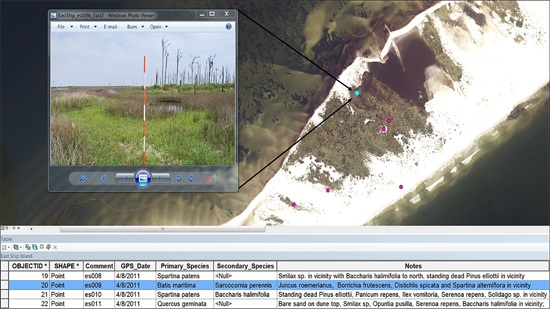
Data
3. Methods
Acknowledgments
Author Contributions
Conflicts of Interest
Abbreviations
| BLOB | Binary large object |
| .gdb | geodatabase file |
| .kmz | keyhole markup language file (compressed) |
| .kml | keyhole markup language file (uncompressed) |
| MS–AL | Mississippi–Alabama |
| OGC | Open Geospatial Consortium |
References
- Fritz, R.A.; Blount, C.; Sokoloski, R.; Singleton, J.; Fuggle, A.; Mcadoo, B.G.; Moore, A.; Grass, C.; Tate, B. Hurricane Katrina storm surge distribution and field observations on the Mississippi barrier islands. Estuar. Coast. Shelf Sci. 2007, 74, 12–20. [Google Scholar] [CrossRef]
- Morton, R.A. First-order controls of extreme-storm impacts on the Mississippi–Alabama barrier-island chain. J. Coast. Res. 2010, 26, 635–648. [Google Scholar] [CrossRef]
- Feagin, R.A.; Williams, A.M. Sediment spatial patterns in a Hurricane Katrina overwash fan on Dauphin Island, Alabama, U.S.A. J. Coast. Res. 2008, 24, 1063–1070. [Google Scholar] [CrossRef]
- Froede, C.R. Changes to Dauphin Island, Alabama, brought about by Hurricane Katrina (August 29, 2005). J. Coast. Res. 2008, 24, 110–117. [Google Scholar] [CrossRef]
- Morton, R.A. Historical changes in the Mississippi–Alabama barrier islands and the roles of extreme storms, sea level and human activities. J. Coast. Res. 2008, 24, 1587–1600. [Google Scholar] [CrossRef]
- Otvos, E.G.; Carter, G.A. Hurricane degradation-barrier development cycles, northeastern Gulf of Mexico: Landform evolution and island chain history. J. Coast. Res. 2008, 24, 463–478. [Google Scholar] [CrossRef]
- Lucas, K.L.; Carter, G.A. Change in distribution and composition of vegetated habitats on Horn Island, Mississippi, northern Gulf of Mexico, in the initial five years following Hurricane Katrina. Geomorphology 2013, 199, 129–137. [Google Scholar] [CrossRef]
- Stockdon, H.F.; Doran, K.S.; Serafin, K.A. Coastal Change on Gulf Islands National Seashore during Hurrican Gustav: West Ship, East Ship, Horn, and Petit Bois Islands; Open-File Report, 2010-1090; U.S. Geological Survey: Reston, VA, USA, 2010; p. 18.
- Anderson, C.P.; Carter, G.A.; Funderburk, W.R. The use of aerial R,G,B imagery and LIDAR in comparing ecological habitats and geomorphic features on a natural versus man-made barrier island. Remote Sens. 2016, 8, 602. [Google Scholar] [CrossRef]
- Funderburk, W.R.; Carter, G.A.; Anderson, C.P. Evaluating the influence of elevation and impact of Hurricane Katrina on radial growth in slash pine (Pinus elliottii var. elliottii Engelm) on Cat Island, Mississippi, U.S.A. J. Coast. Res. 2016, 32, 483–489. [Google Scholar] [CrossRef]
- Jeter, G.W., Jr.; Carter, G.A. Habitat change on Horn Island, Mississippi, 1940–2010, determined from textural features in panchromatic vertical aerial imagery. Geocarto Int. 2016, 31, 985–994. [Google Scholar] [CrossRef]
- ArcGIS Desktop: Release 10.3. Environmental Systems Research Institute (ESRI) Home Page. Available online: www.esri.com (accessed on 26 September 2016).
- Lucas, K.L.; Carter, G.A. The use of hyperspectral remote sensing to assess vascular plant species richness on Horn Island, Mississippi. Remote Sens. Environ. 2008, 112, 3908–3915. [Google Scholar] [CrossRef]
- Lucas, K.L.; Carter, G.A. Decadal changes in habitat-type coverage on Horn Island, Mississippi, U.S.A. J. Coast. Res. 2010, 26, 1142–1148. [Google Scholar] [CrossRef]
- ENVI: Release 4.3. Harris Geospatial Solutions Home Page. Available online: http://www.harrisgeospatial.com (accessed on 26 September 2016).
- USGS Earth Resources Observation and Science (EROS) Center Home Page. Available online: http://eros.usgs.gov (accessed on May–December 2010).
- Trimble GeoExplorer Model XT03: Trimble Home Page. Available online: https://www.trimble.com (accessed on 26 September 2016).


| Attribute | Type | Stored as | Length | Description |
|---|---|---|---|---|
| OBJECTID | Object ID | - | - | - |
| SHAPE | Geometry | Point | - | Point data for sample locations |
| Comment | Text | String | 32 | Sample point name |
| GPS_Date | Date | mm/dd/yyyy | - | Date collected |
| Northing | Double | meter | 8 bytes | Location WGS 84 UTM 16N |
| Easting | Double | meter | 8 bytes | Location WGS 84 UTM 16N |
| Latitude_DD | Double | degree | 8 bytes | Location GCS WGS 84 |
| Longitude_DD | Double | degree | 8 bytes | Location GCS WGS 84 |
| Primary_Species | Text | String | 50 | Dominant vegetation |
| Secondary_Species | Text | String | 50 | Less dominant vegetation |
| Notes | Text | String | 250 | Additional site information |
| Sampling Period | Island | Land Area (ha) * | Num. of Points | Num. of Photos | Specific Sampling Area (ha per Point) † | Num. of Sampling Days ‡ |
|---|---|---|---|---|---|---|
| 6 May–8 October 2010 | Horn | 680 | 111 | 355 | 6.1 | 13 |
| 20 October–19 November 2010 | Dauphin | 334 | 50 | 200 | 6.7 | 5 |
| 22 November 2010–20 January 2011 | Petit Bois | 377 | 61 | 243 | 6.2 | 4 |
| 14 December 2010 | Sand | 66 | 10 | 40 | 6.6 | 1 |
| 28 January–6 May 2011 | Cat | 725 | 101 | 552 | 7.2 | 9 |
| 8 April 2011 | East Ship | 66 | 11 | 63 | 6.0 | 1 |
| 18 May–19 July 2011 | West Ship | 180 | 31 | 121 | 5.8 | 3 |
| 6 May 2010–19 July 2011 | Islands Combined | 2428 | 375 | 1574 | 6.5 | 36 |
© 2016 by the authors; licensee MDPI, Basel, Switzerland. This article is an open access article distributed under the terms and conditions of the Creative Commons Attribution (CC-BY) license (http://creativecommons.org/licenses/by/4.0/).
Share and Cite
Carter, G.A.; Anderson, C.P.; Lucas, K.L.; Hopper, N.L. Land Cover Data for the Mississippi–Alabama Barrier Islands, 2010–2011. Data 2016, 1, 16. https://0-doi-org.brum.beds.ac.uk/10.3390/data1030016
Carter GA, Anderson CP, Lucas KL, Hopper NL. Land Cover Data for the Mississippi–Alabama Barrier Islands, 2010–2011. Data. 2016; 1(3):16. https://0-doi-org.brum.beds.ac.uk/10.3390/data1030016
Chicago/Turabian StyleCarter, Gregory A., Carlton P. Anderson, Kelly L. Lucas, and Nathan L. Hopper. 2016. "Land Cover Data for the Mississippi–Alabama Barrier Islands, 2010–2011" Data 1, no. 3: 16. https://0-doi-org.brum.beds.ac.uk/10.3390/data1030016