Article

Accessibility in European Peripheral Territories: Analyzing the Portuguese Mainland Connectivity Patterns from 1985 to 2020

by
José Manuel Naranjo Gómez
1,2,3,
Ana Vulevic
3,4,
Gualter Couto
5 and
Rui Alexandre Castanho
2,3,6,*
1
Agricultural School, University of Extremadura, 06007 Badajoz, Spain
2
CITUR-Madeira—Centre for Tourism Research, Development and Innovation, 9000-082 Funchal-Madeira, Portugal
3
VALORIZA—Research Centre for Endogenous Resource Valorization, 7300-511 Portalegre, Portugal
4
Department of Urban Planning and Architecture, Institute of Transportation—CIP, 11000 Belgrade, Serbia
5
School of Business and Economics and CEEAplA, University of Azores, 9500-321 Ponta Delgada, Portugal
6
Faculty of Applied Sciences, WSB University, 41-300 Dabrowa Górnicza, Poland
*
Author to whom correspondence should be addressed.
Submission received: 21 May 2021 / Revised: 8 June 2021 / Accepted: 14 June 2021 / Published: 20 June 2021
(This article belongs to the Special Issue Planning Peripheral and Ultra-Peripheral Infrastructures)

Abstract

:
The inner periphery European countries, as is the case of Portugal, are characterized by poor access to essential areas and services of general and social relations. Contextually, this paper aims to explore the linkages between inner peripheries, ultra-peripherality concepts, and the concept of accessibility from 1985 to 2020, in parallel with the analysis of some demographic trends in the same research period. Thus, the study deals with accessibility and the analysis of accessibility-related spatial distribution to represent the traditional core—periphery pattern, with the highest accessibility in the center of the mainland and west coastal area, and the lowest accessibility in remote regions. The results show that the distribution of the road infrastructure is not uniform in Portugal. Furthermore, the NUTS II regions of PT13 Lisboa e Vale do Tejo (the Lisbon region) and PT11 Norte (northern Portugal) have the greatest road per km2. The Lisbon region has the highest concentration of national roads globally, while the northern region has the highest concentration of municipal roads. These two regions are, by far, the most densely populated, encompassing about ¾ of the national population and GDP.

Graphical Abstract

1. Introduction

In recent years, the term peripherality, which draws attention to spatial connections, is increasingly used rather than the terminal of marginality, implying a low level of social and economic development [1,2,3,4]. According to Bock [5] “Whereas in the past, the main cause was ascribed to geography, this has changed in the sense that the lack of resources is now explained as a result of a lack of socioeconomic and political connections (‘connectivity’) and, hence, of relational ‘remoteness’ that is not necessarily bounded to geographical location (…) Geographical remoteness, as such, therefore does not cause marginalization, nor does central location promise prosperity”.
Contextually, the causal connection between peripherality and performance is reversed. Peripherality can be spatial and aspatial, or a combination of both, with the characteristic of disconnection, lack of drivers, weak interaction, and not backward socio-economic development. Access areas may surround that region and yet be inaccessible, with poor appropriate access to services of general interest, whether as a result of geographical distances or a change in service delivery technology.
From the perspective of 2021, it is also essential to understand what is meant by the term “inner periphery”, which was first used and defined in the European policy document in the borrowed edition of the preparatory meeting for the territorial proposal meeting in January by Vati Nonprofit Ltd. [6], as follows: “Inner peripheries are unique types of rural peripheries in the European sense. The vast majority of these regions are located in Central and Eastern, and Southeastern Europe and most have serious problems. Besides, their peripherality comes primarily due to the poor availability and scarcity of real urban centers where central functions can be concentrated. These problems stem from the historical underdevelopment of these territories and often consist of specific network characteristics of settlements or social characteristics. The main problems of these areas are their weak and vulnerable regional economies and the lack of adequate job opportunities (…) In these circumstances, the negative demographic processes, especially emigration and population aging, are becoming stronger and stronger. These trends create conditions for social exclusion and even territorial exclusion from major socio-economic processes and opportunities. Although rural ghettos are largely the result of social factors, ethnic segregation can exacerbate difficult situations”.
The broad definition of inner periphery was further explored and enhanced by [7,8,9]. The inner periphery is characterized by poor access to essential areas and services of general and social relations. During the 1980s and 1990s, using different models, spatial peripherality was measured, applying mainly Newton’s gravity as an analogy of “economic potential” [10,11,12,13]. Indicators were mapped, and they tested for different modes of transport to investigate the type of effects produced by the peripherals area. After the end of the 1990s, numerous transport infrastructure projects were implemented in Europe to promote regional cohesion and improve the accessibility of peripheral regions [14,15]. Portugal’s mainland as a peripheral region was vital in some of these projects. Related to this for the last decade and a half, we have been analyzing in the paper whether the new infrastructure has achieved its goal in this peripheral European region, or whether one with demographic real estate has created internal peripheral areas. The European Union (EU) has defined guidelines for sustainable transport infrastructure by adding an assessment of accessibility, socio-economic impacts, and regional cohesion in peripheral and ultra-peripheral regions [7,8,9]. Nevertheless, after analyzing the accessibility of mainland Portugal, the question arises whether this has given good results in overcoming the peripherality of some regions [16,17,18,19,20]. In this sense, this paper aims to explore the linkages between inner peripheries, ultra-peripherality concepts, and the concept of accessibility, from 1985 to 2020, in parallel with the analysis of some demographic trends in the same research period.
The paper deals with accessibility and analysis of the spatial distribution of accessibility related to the representation of the traditional core–periphery pattern, with the highest accessibility in the center of the mainland and west coastal area, and the lowest accessibility in remote regions. However, this study only focuses on access by road.

2. A Brief Literature Review

Over the last decades, many accessibility studies have analyzed European core–periphery issues (see: [1,2,3,4,21,22,23]). Here is a brief review of that critical accessibility concept and models [24,25]. Also, different definitions of peripherality, marginality, inner peripheries, and inner areas have increasingly led to terminological confusion in the scientific community. There have been numerous debates about the polarization of space [26,27,28,29], about centers that have much more potential for creating innovation and growth, and peripheries that are dependent on centers.
Pileček and Jančák [30] says the following: “The peripherality of an area is connected with spatial (situational) characteristics such as distance and transport accessibility. Marginality, on the other hand, is shaped by a ”multi-dimensional“ spectrum of problems, from economic and cultural to social, political and historical”. In the EU, also the topic of “inner periphery” has been dealt with by ESPON since 2013, and the topic was further researched in 2017. According to ESPON, the inner peripheries suffer from demographic decline, lack of services of general interest to SGI, lack of accessibility, lack of economic diversity, and proximity to natural barriers [31].
According to Spiekermann and Neubauer [32]: “In the context of spatial development, the quality of transport infrastructure in terms of capacity, connectivity, travel speeds etc. determines the quality of locations relative to other locations, i.e., the competitive advantage of locations usually measured as accessibility. Investment in transport infrastructure leads to changing location qualities and may induce changes in spatial development patterns”.
The use of accessibility indicators concerning new European trends in transport, and the consolidation of the concept of accessibility and the concept of peripherality is probably a big step forward. Over the last decades, a vast number of accessibility studies addressing European core–periphery issues have been published. Many of them contribute to the question of peripherality [16,32,33,34,35,36,37,38].
The accessibility model [36] calculates the minimum paths for the road network—i.e., the minimum travel times among the centroids of the NUTS-3 regions and the minimum travel times between the centroids of the NUTS-3 regions, by summing up the population in all other regions, including those outside the ESPON space weighted by the travel time to go there. The accessibility values are standardized to the average accessibility of the ESPON space.
Thereby, accessibility by road is characterized by a clear distinction of center and periphery, and accessibility by road is the unique modal accessibility indicator that reflects the ‘Blue Banana’, the central area is now called the European pentagon [36]. All other accessibility indicators provide different results.
In this regard, the equity and dynamic statements of some European accessibility models are shown in Table 1.
Gutiérrez et al. [37], and Gutiérrez and Urbano [38] calculated average travel time by road and rail from about 4000 nodes. They used a multi-modal network to 94 agglomerations, with a population of more than 300,000 with and without planned infrastructure improvements. Additionally, road travel time included road and car ferry travel times [32].
Copus [39,40] is developed “peripherality indicators” for NUTS-2 and NUTS-3 regions, based on road-based potential measures of the Keeble type. Accessibility is presented as a peripherality index with values from 0 to 100—i.e., most central to most peripheral, which, according to Spiekermann and Neubauer [32]: “ (…) takes account of different average speeds for different classes of road and realistic ferry crossing and check-in times, EU border crossing delays and statutory drivers’ rest breaks”.
As transportation infrastructure is an essential policy tool to support regional economic development, it is incredibly policy-relevant to know which regions have benefited their location and which regions have not. There has been an increase in network coverage of major roads in peripheral parts of Europe [43,44]. This has also added to the growth of accessibility in large parts of Portugal, but this has not been followed by an equal progress and better development [16,43,44]. However, the corresponding improvement in development did not meet expectations, as a significant part of the southern and border areas had a population decline.
In 2007, the European Commission (EC) approved the European program for cross-border cooperation between Spain and Portugal for 2007–2013 [45,46]. This step also did not significantly impact the already existing chronic development problems and population decline in particular areas. In addition, there is a significant correspondence between the degree of peripherality and population loss. All efforts are now focused on improving connectivity and basic infrastructure in border areas, in line with new approaches aimed at improving competitiveness, promoting employment, and strengthening socio-economic development and institutional integration in the southern and extreme northern parts and the border areas of Portugal [16].

3. Materials and Methods
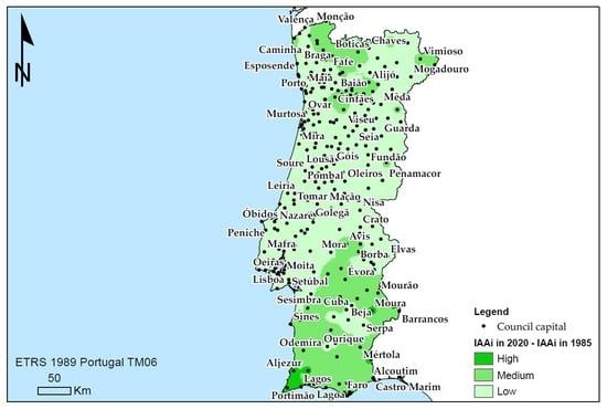
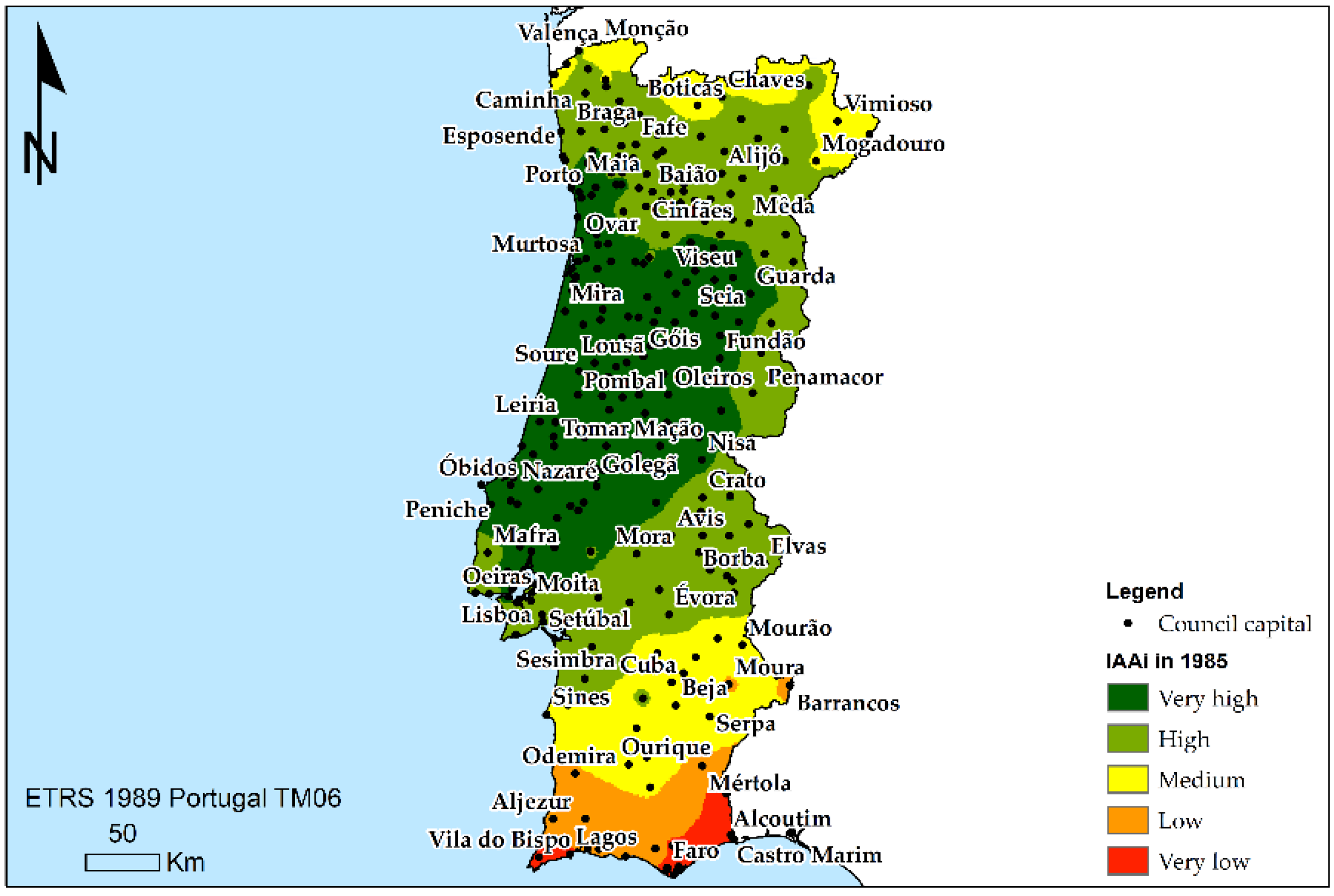
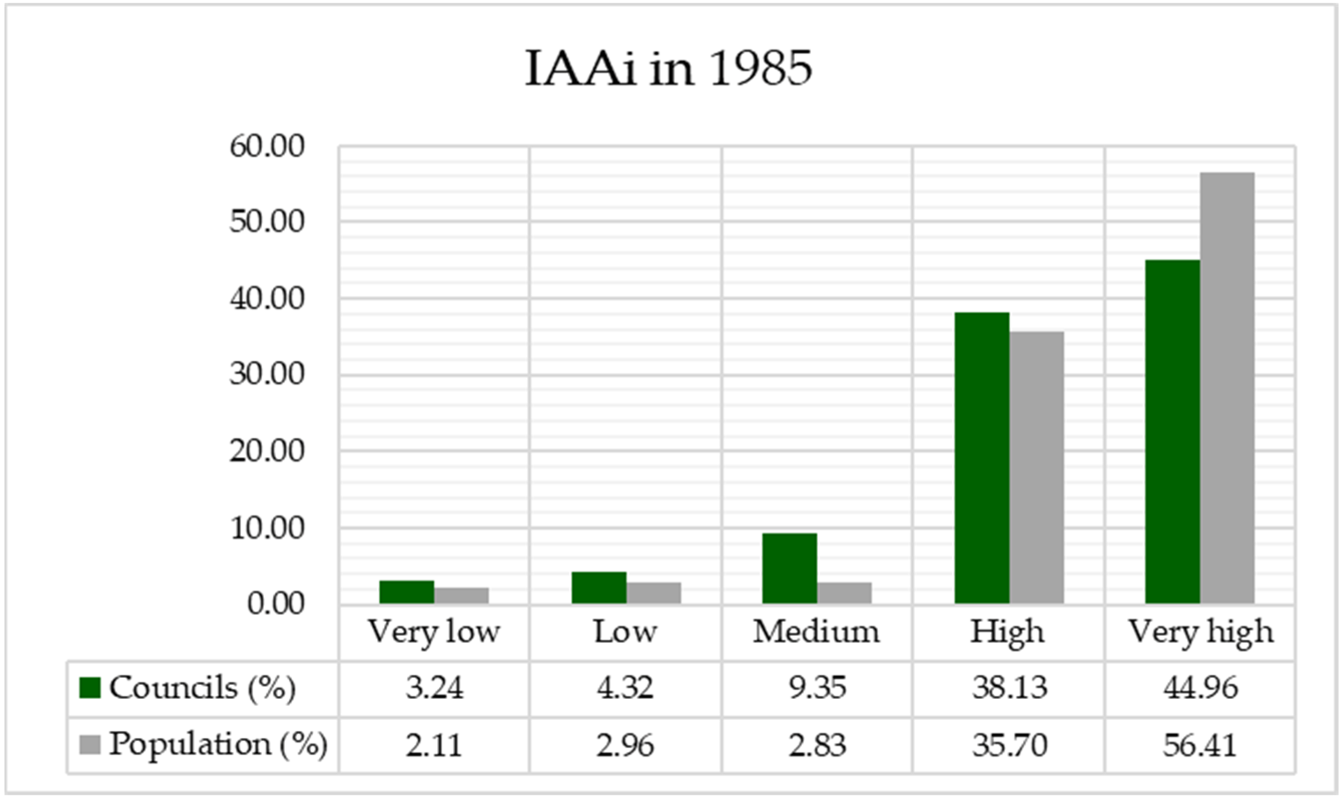
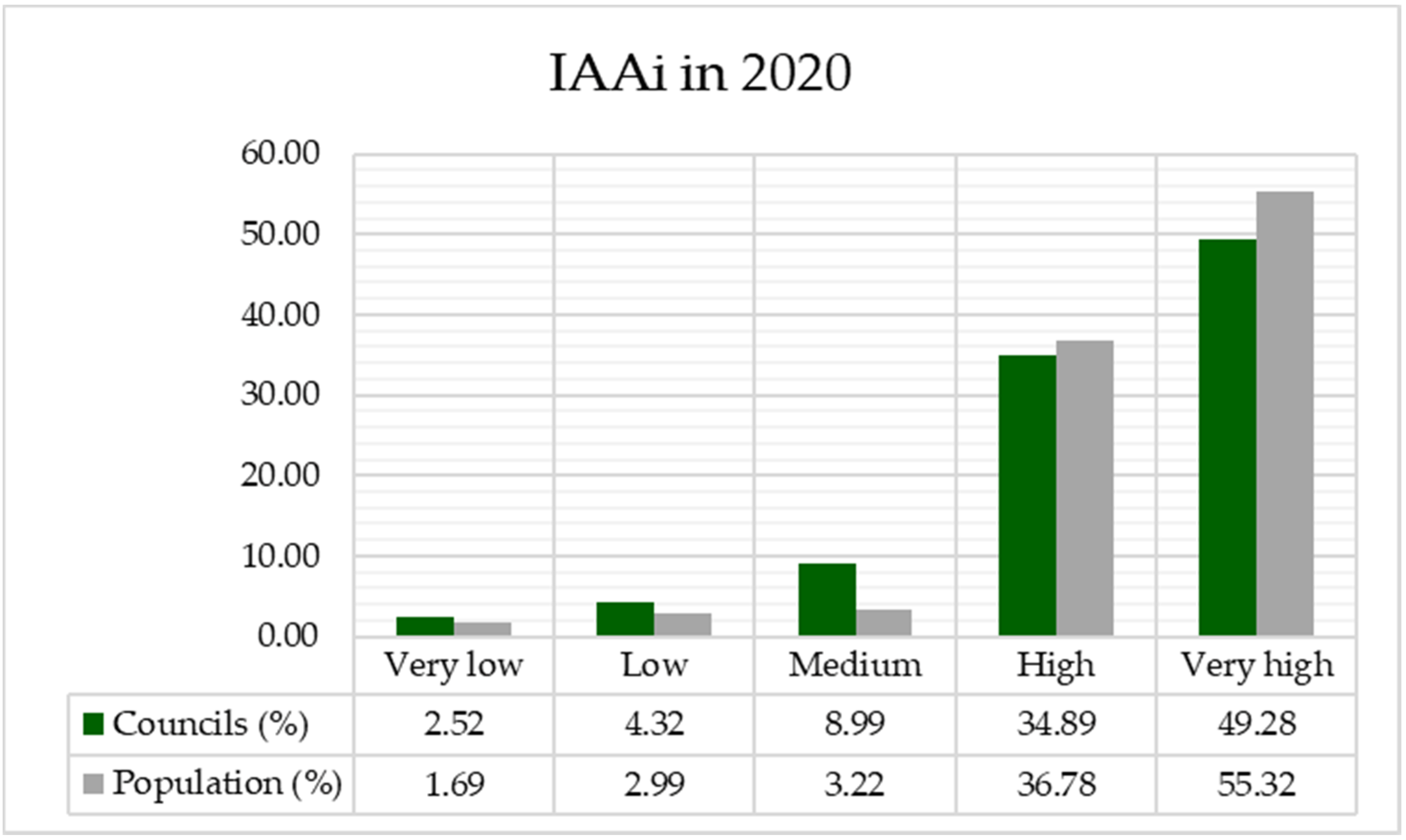
The various actions in the road Portuguese mainland network of Portugal between 1985 (Figure 1) and 2020 (Figure 2) have been analyzed, taking into account the variations in territorial accessibility.
Firstly, the road network has been digitized for the years analyzed by linear graphical features and they have been associated with the maximum speed allowed to circulate. Different data sources such as the 1985 road plan and the 2020 road plan were used to achieve this goal.
Secondly, the arc-node topology was obtained using ArcGis 10.5. software made by Environmental Systems Research Institute (ESRI) placed in the United States, Redlands, California. Thus, each of the roads was divided into sections when intersecting with another road, keeping its category and speed associated as alphanumeric information. The length of each of the line sections that were previously generated was then determined. To then relate the speed and length of each section and determine in minutes the impedance to travel them, that is, the resistance to movement or the time it would take to cross each section.
Thirdly, the other layer obtained was the capital of each of the councils. This information was obtained from various sources of information (see: https://dados.gov.pt/es/; https://snig.dgterritorio.gov.pt/ and https://geogrid.ine.pt/, accessed on 15 May 2021). Each of the capitals was represented by a period, and as associated alphanumeric information, the name of each capital and the resident population were recorded.
The next step was to calculate the origin–destination matrix that consisted of analyzing the minimum time obtained from a council capital to the remaining council capitals in mainland Portugal through the road network in 1985 and 2020.
The next step was to determine the absolute accessibility index I (IAAi) (see: [2,3,4,17,18,19,20,21,22,23]), as follows:
I A A i = j = 1 n ( I R i j P C A E j ) j = 1 n P C A E j
where I R i j is the minimum time between node ij across the network, and PCAEj is the population of council capitals. The population was used once it was an expected value of the importance of an urban settlement. As a result, this index weights access time based on the importance of each population, given by the weight given by the resident population. For this reason, this index makes it possible to determine the significance of each council capital compared to the other council capital, taking into account its accessibility with the network of roads available in each of the years analyzed. Consequently, this accessibility indicator—through the interaction of the different nodes that make up the road network—determines the importance of each of the capitals of the councils according to the accessibility to the rest of the capitals. Additionally, the indicator allows determining the degree of connectivity of each council capital to the rest according to the population resident in each of them. Thereby, it is possible to identify which council capitals are better or worse communicated.
However, the indicator has a limitation once it depends on the variable or variables used—i.e., the impedance between the arcs and the weighting of the nodes varies. For this reason, variables are justified because the larger population residing in one population center, the greater their relative importance to the rest. In addition, the time to cross each stretch of road to reach other council capitals according to the maximum speed of circulation also determines the separation between the different capitals and the need to make the displacement.
The next step was to classify each of the council capitals according to their degree of accessibility. To achieve this purpose, thematic maps were produced according to the values of the accessibility indicator used, allowing the territory to be classified according to the low and lowest values in five equal intervals. Also, the percentage of municipality capital and the population resident were determined according to the degree of accessibility available to those populations.

4. Results

From the information obtained from the absolute accessibility indicator (IAAi) the territory of Portugal mainland was classified into the following five categories of accessibility: very high, high, medium, low and very low.
The map (Figure 3) allows territorial locality of which territories had greater accessibility in 1985. In this case, they are located in the northern half. On the contrary, most peripheral regions have lower levels of accessibility. It can therefore be said that the accessibility model in 1985 corresponds to a center–periphery model. In this sense, councils from Lisbon located further south to Porto in the north are in privileged in terms of accessibility. In contrast, the southern area shows regions where they are isolated from the rest of the territory.
The data (Figure 4) for the percentage of councils and the population resident therein make it possible to determine that most of the population (56.41%) resides in areas with very high accessibility. This makes it possible to determine that the road network in 1985 offered very good accessibility to most of the population. In addition, the population density could also be higher in these councils, home to 56.41% of the population, or more than half of the population of Portugal mainland. On the contrary, councils with very low or low accessibility have a very little population, since these councils have low population density. As a result, it can be said that road planning in 1985 is based on population criteria—i.e., roads were planned to serve as many people as possible.
The map (Figure 5) again shows a center–periphery model, as the highest levels of accessibility are again located in the northern half and progressively descend towards the peripheral areas. In addition, as before, within that center–periphery model, the higher values are located in places closer to the coast. Therefore, it can be said that despite the actions carried out on the mainland Portuguese road network between 1985 and 2020, the center–periphery model has not been changed. However, compared to the most isolated areas that used to be located in the southern part, with a very low classification, these are reduced. However, some regions are still in isolation from others.
Figure 6 shows data in 2020 that are similar to those obtained in 1985 (Figure 4). Again, more than half of the population has the best accessibility, and the lowest level of accessibility is home to a small population. Therefore, the criteria in 2020 for road planning, design, and construction have been as in 1985, to serve or connect the most densely populated population capitals. Nevertheless, account should be taken of those populations that certainly have certain isolation levels when they have low levels of accessibility.

5. Discussion

After the 1990s, numerous transport infrastructure projects were implemented in Europe to promote regional cohesion by improving the accessibility of peripheral regions [13,47,48,49,50,51]. Portugal’s mainland, as a peripheral region, was vital in some of these projects. After a decade and a half, we analyzed whether the new road infrastructure has achieved its goal in this peripheral European region. In general, the most peripheral territories have lower levels of accessibility [6,11,15,52,53,54,55,56,57,58], which leads to a situation in which most of the internal border area becomes the inner periphery in EU space.
Portugal’s mainland contrasts with an unbalanced territory, with an intense concentration of population, economic activity, infrastructure, and utilities along a coastal area, central and north parts. By contrast, most of the inland part of the region is composed of a succession of lagging rural areas showing the following characteristics of rural peripherality: aging population, depopulation, local, fragmented labor markets, and low level of access to goods and services of general interest, among several other features.
This study explores the relationship between the changes in road accessibility levels from 1985 to 2020 that bring improvements in the transport network and indicators that are most often used in accessibility research—i.e., the population in 1985 and 2020.
When we visualized these two components through the appropriate maps, we saw no significant differences in the level of accessibility in 1985 and 2020.
Therefore, it is possible to identify the following two main types of territory: (i) territories that have a high or very high level of accessibility (the most northern and middle part of Portugal mainland); and (ii) the very peripheral territories with lower levels of accessibility, on the north and south. A tiny percentage of municipalities (about 15% in total) have low and medium accessibility, and only about 6% of them live in them (Figure 4 and Figure 6). This is the population of the peripheral parts of the north and south of Portugal. The inner central parts of mainland Portugal have high levels of accessibility that are increasing from the border with Spain to the coastal belt. The higher values are located in municipalities along the coast. In peripheral areas, the local road network is relatively sparse and unimproved, and the small towns within the area provide only essential services.
All of this points to the classic center–periphery model, which has deepened since 1985. In 2020, there existed a few differences in the level of accessibility. Figure 6 shows that data in 2020 are similar to those obtained in 1985 (Figure 4). The current results show similarities in those two years and indicate tendencies to change something in the future regarding overcoming center–periphery models. Also, they are pointing out the importance of a selective road infrastructure policy in the national/regional context in the future. The result of wrongly planned infrastructure investment may also result from inadequate policy-making and scarce economic resources. When the responsibility for investment planning is decentralized, regional and local authorities may lack sufficient financial leverage to implement investments with higher returns.
Excessive or inadequately planned infrastructure investment may also be the result of inadequate policy-making and scarce economic resources. Therefore, the question is whether only national and international networks are connecting already developed regions and municipalities. In contrast, are other roads that should enable the connection of peripheral parts with national road routes again neglected? These results highlight the importance of a selective road infrastructure policy in a national/regional context. The most appropriate transport solution would be to consider small-scale infrastructure and integrated planning in peripheral and economically underdeveloped areas to remove barriers to accessing people to workplaces and services of general interest.
There is the presence of the classic dichotomy between central and peripheral areas. Peripheral areas have access to services of general interest that score well below the standards of the surrounding central areas. Some of them are at the center of major regional corridors, and they are not classic peripherality examples regarding accessibility. There must undoubtedly be other socio-economic factors, not just geographical, which help explain the poor economic performance of these areas. Besides, according to Bock [1]: “Whereas in the past, the main cause was ascribed to geography, this has changed in the sense that the lack of resources is now explained as resulting from a lack of socioeconomic and political connections (‘connectivity’) and, hence, of relational ‘remoteness’ that is not necessarily bounded to geographical location (…) Geographical remoteness, as such, therefore does not cause marginalization, nor does central location promise prosperity”. Therefore, the causal connection between peripherality and performance is, in consequence, inverted.” In this regard, Copus [12] affirms that: “This is the popularity among both academics and the policy community of using the (spatial) concept as an analogy or metaphor for poor socio-economic performance, so that any lagging region is described as a “periphery” regardless of its location, and justified in terms of (inputted) non-spatial forms of proximity”.
Although, what is not shown by the results of our research, because only road accessibility is analyzed, most of the cross-border area is characterized by an overall weak urban network, low-density settlement, continuous depopulation, fragility of economic structure and inaccessibility of public services. Also, we can recognize the other obstacles due to political borders, many administrative obstacles and effects related to economic disparities, sometimes natural barriers [58,59,60,61]. Analyzing the criteria of inner periphery [8], we can conclude that these border territories of Spanish–Portuguese have all of them. A higher travel time to regional centers is needed, there is poor access to services of general interest, municipalities have low economic performance, depopulation in is progress to improve the access to services [59,60,61].

6. Conclusions

Portugal has a particular geographical location in Europe, which could be seen as a disadvantage. Being located in Europe’s periphery, Portugal depends on the relationship with the Spanish transport infrastructure to reach the rest of Europe by land. Due to these circumstances, cross-border projects have a particularly significant role in Portugal’s development.
About 70% of Portugal’s population lives in the coastal area from the Spanish border to Lisbon. The southern part and the hinterland of the coastal area are not densely populated. More than 10% of the population lives in the cities of Lisbon and Porto.
After a robust economic growth period in Portugal, which ended by 2000, came a period of economic stagnation, which has lasted until today and has limited the number of public resources available for investment, such as in the transport sector. This problem has been further compounded by the fact that the public deficit in Portugal has been breaching the Eurozone limit of three percent of GDP since 2001. The government is now slashing state spending to reign in the public deficit. The poor economic performance is causing a lack of national resources, both public and private, for transport-related investments.
The distribution of the road infrastructure is not uniform in Portugal, as we see in this study. The NUTS II regions of PT13 Lisboa e Vale do Tejo (the Lisbon region) and PT11 Norte (northern Portugal) have the greatest road per km2. The Lisbon region has the highest concentration of national roads globally, while the northern region has the highest concentration of municipal roads. These two regions are, by far, the most densely populated, encompassing about ¾ of the national population and GDP.
On the other hand, increased accessibility in the CB (cross-border) area can be significantly influenced by transport projects, and the benefits and possibilities of INTERREG implementation. However, in this study, we see how things go over time when we analyze road accessibility. They are an essential contribution to the ongoing efforts to improve connectivity between the EU center and its peripheral regions, and strengthen the Iberian Peninsula’s position as a Western European gate, but this is external accessibility. The accessibility by road and endowment of road infrastructure made different levels of accessibility on a national level, which led to new inner peripheries, that is, internal accessibility in a low-density territory characterized by low accessibility values due to a lack of infrastructure and services that produce inner periphery areas [61].
Also, a minimum level of transport infrastructure is necessary for regional competitiveness, but this is not necessarily the same in all regions. In that case, the solution can be considering the improvement in low-density accessibility programs, using the advantage of capacities that are already there, new “multimodal intelligent solutions and networks”, and “alternative forms of service provision” [61]. In general, in recent years, the intention that accessibility is increasingly moving away from the “hard” economic/competitiveness idea of “economic potential”, which defined early peripherality modeling towards a softer, socio-economic center on services of common interest and associated well-being for rural residents. Unlike traditional transport planning, it is supposed that more information should be collected about transport patterns, distance, travel time, and public transport in future plans.

7. Study Limitations and Future Research Lines

Although this study provides us with some insights on the accessibility dynamics and patterns in peripheral European territories, as is the case of Portugal mainland, if more studies were carried out, we would intercross more variables and significant findings to develop this thematic domain.
Furthermore, the fast changes in regional policies and societal responses should be recognized in these ultra-peripheral regions. Particular changes, concurrently with the Portuguese mainland’s diverse administrative systems, direct us to the necessity for close monitoring of the tendencies and dynamics of accessibility and connectivity, and, therefore, to conduct different territorial management to pursue the aspired sustainable development approaches.
In this research, the methods used are simplistic. For example, in further studies on this topic, spatial analysis and quantitative assessment should be used rather than a simple application of GIS analysis. Also, this study only focuses on the period 1985–2020; thus, if a previous period of time was to be selected, more outcomes could be obtained.

Author Contributions

Conceptualization, R.A.C. and J.M.N.G.; methodology, J.M.N.G. and A.V.; software, J.M.N.G.; validation, R.A.C., J.M.N.G. and G.C.; formal analysis, A.V.; investigation, J.M.N.G. and A.V.; resources, J.M.N.G.; data curation, A.V. and G.C.; writing—original draft preparation, J.M.N.G. and R.A.C.; writing—review and editing, R.A.C. and G.C.; visualization, J.M.N.G.; supervision, R.A.C. and J.M.N.G.; project administration, R.A.C.; funding acquisition, G.C. All authors have read and agreed to the published version of the manuscript.

Funding

This publication has been made possible thanks to funding granted by the Consejería de Economía, ciencia y Agenda Digital from Junta de Extremadura and by the European Regional Development Fund of the European Union, through the reference grant GR18052. This paper is financed by Portuguese National Funds through FCT—Fundação para a Ciência e a Tecnologia, I.P., project number UIDB/00685/2020; also, by the program of the Minister of Science and Higher Education titled “Regional Initiative of Excellence” in 2019–2022, project number 018/RID/2018/19, the amount of funding PLN 10 788 423,16.

Institutional Review Board Statement

Not applicable.

Informed Consent Statement

Not applicable.

Conflicts of Interest

The authors declare no conflict of interest.

References

  1. Gualter, C.; Castanho, R.A.; Pimentel, P.; Carvalho, C.; Sousa, Á.; Graça Batista, M.; Vulevic, A.; Naranjo Gómez, J.M. Transportation and Infrastructures’ Sustainability in Ultra-peripheral Territories: Studies Over the Azores Region. In Trends and Applications in Information Systems and Technologies; Rocha, Á., Ed.; Springer Nature: Cham, Switzerland, 2021; pp. 1–9. [Google Scholar] [CrossRef]
  2. Castanho, R.A.; Naranjo Gómez, J.M.; Vulevic, A.; Behradfar, A.; Couto, G. Assessing Transportation Patterns in the Azores Archipelago. Infrastructures 2021, 6, 10. [Google Scholar] [CrossRef]
  3. Castanho, R.A.; Behradfar, A.; Vulevic, A.; Naranjo Gómez, J. Analyzing Transportation Sustainability in the Canary Islands Archipelago. Infrastructures 2020, 5, 58. [Google Scholar] [CrossRef]
  4. Naranjo Gómez, J.; Castanho, R.A.; Cabezas, J.; Loures, L. Assessment of High-Speed Rail Service Coverage in Municipalities of Peninsular Spain. Infrastructures 2020, 5, 11. [Google Scholar] [CrossRef] [Green Version]
  5. Bock, B. Rural Marginalisation and the role of Social Innovation: A Turn towards Nexogenous Development and Rural Reconnection. Sociol. Rural. 2016, 56, 552–573. [Google Scholar] [CrossRef] [Green Version]
  6. Ministry of National Development; Vàti Nonprofit Ltd. The Territorial State and Perspectives of the European Union, 2011 Update. Background document for the Territorial Agenda of the European Union 2020. In Proceedings of the Informal Meeting of Ministers Responsible for Spatial Planning and Territorial Development, Gödöllő, Hungary, 19 May 2011; p. 57. [Google Scholar]
  7. ESPON GEOSPECS. Inner Peripheries: A Socio-Economic Territorial Specificity, Luxembourg [pdf]. 2014. Available online: https://www.espon.eu/sites/default/files/attachments/GEOSPECS_Final_Report_inner_peripheries_v14.pdf (accessed on 6 April 2016).
  8. Vulevic, A.; Obradovic, V.; Castanho, R.; Djordjevic, D. Cross-Border Cooperation (CBC) in a Multi-Level Governance System in Southeastern Europe Territories. The Case of ROMANIA—SERBIA Border Space and the Associated Challenges and Obstacles for their Integration. In Proceedings of the 1st Central and Eastern European Planning Conference, Budapest, Romania, 23–24 May 2018; Spaces Crossing Borders, Institute of Geography, Geoeconomy and Sustainable Development, Corvinus University of Budapest: Budapest, Romania, 2018; p. 51, ISBN 978-963-503-701-8. [Google Scholar]
  9. ESPON. Inner Peripheries in Europe. Possible Development Strategies to Overcome their Marginalising Effects. 2018. Available online: https://www.espon.eu/sites/default/files/attachments/ESPON-Policy-Brief-Inner-Peripheries.pdf (accessed on 19 April 2021).
  10. Keeble, D.; Owens, P.L.; Thompson, C. Regional accessibility and economic potentialin the European Community. Reg. Stud. 1982, 16, 419–432. [Google Scholar] [CrossRef]
  11. Keeble, D.; Offord, J.; Walker, S. Peripheral Regions in a Community of Twelve Member States; Commission of the European Community: Luxembourg, 1988. [Google Scholar]
  12. Copus, A. From Core-Periphery to Polycentric Development; Concepts of Spatial and A spatial Peripherality. Eur. Plan. Stud. 2001, 9, 539–552. [Google Scholar] [CrossRef]
  13. Hanna, S. Finding a place in the world-economy: Core-periphery relations, the nation-state and the underdevelopment of Garrett County, Maryland. Political Geogr. 1995, 14, 451–472. [Google Scholar] [CrossRef]
  14. ESPON. Transport Services and Networks: Territorial Trends and Basic Supply of Infrastructure for Territorial Cohesion, Final Report for Espon Project 1.2.1; ESPON: Luxembourg, 2004; Available online: https://www.espon.eu (accessed on 6 April 2021).
  15. Lucatelli, S.; Carlucci, C.; Guerrizio, M. A strategy for the Inner Areas of Italy. In Proceedings of the European Rural Futures Conference, Asti, Italy, 8 October 2013. [Google Scholar]
  16. Ribeiro, A.; Silva, J. Cross Border Acessibility and Spatial Development in Portugal and Spain. In Proceedings of the ERSA 2010 Congress, Jonkoping University, Jonkoping, Sweden, 19–23 August 2010. [Google Scholar]
  17. Vulevic, A.; Castanho, R.A.; Naranjo Gómez, J.M.; Cabezas, J.; Fernández-Pozo, L.; Garrido Velarde, J.; Martín Gallardo, J.; Lousada, S.; Loures, L. Common Regional Development Strategies on Iberian Territories. A Framework for Comprehensive Border Corridors Governance: Establishing Integrated Territorial Development; IntechOpen: London, UK, 2021. [Google Scholar] [CrossRef]
  18. Vulevic, A.; Castanho, R.A.; Naranjo Gómez, J.M.; Loures, L.; Cabezas, J.; Fernández-Pozo, L.; Martín Gallardo, J. Accessibility Dynamics and Regional Cross-Border Cooperation (CBC) Perspectives in the Portuguese—Spanish Borderland. Sustainability 2020, 12, 1978. [Google Scholar] [CrossRef] [Green Version]
  19. Vulevic, A.; Obradovic, V.; Castanho, R.A.; Djordjevic, D. Cross-Border Cooperation (CBC) in a Multi-Level Governance System in Southeastern Europe Territories: How to Manage Territorial Governance Processes in Serbia-Romania Border Space. In Cross-Border Cooperation (CBC) Strategies for Sustainable Development; Castanho, R.A., Ed.; IGI Global: Hershey, PA, USA, 2020; pp. 70–85. ISBN 139781799825135. [Google Scholar] [CrossRef]
  20. Castanho, R.; Cabezas, J.; Fernández-Pozo, L.; Vulevic, A.; Naranjo Gómez, J.; Martín Gallardo, J.; Loures, L. Common Regional Development Strategies on Iberian Territory. Envisioning New Horizons: Post 2020. In Enfoques en la Planificación Territorial y Urbanística; Thomson Reuters: Navarra, Spain, 2018; pp. 293–303. ISBN 9788491776703. [Google Scholar]
  21. Vulevic, A.; Macura, D.; Djordjevic, D.; Castanho, R. Assessing Accessibility and Transport Infrastructure Inequities in Administrative Units in Serbia’s Danube Corridor Based on Multi-Criteria Analysis and GIS Mapping Tools. Transylv. Rev. Adm. Sci. 2018, 53, 123–142. [Google Scholar] [CrossRef] [Green Version]
  22. Vulevic, A.; Castanho, R.A.; Gómez-Naranjo, J.; Cabezas, J.; Fernández-Pozo, L. Transport Accessibility to Achieve Sustainable Development. Principles for its Application in CBC Projects: The Euro-City Elvas-Badajoz. In Proceedings of the 16th Congress on Public and Non-profit Marketing (IAPNM), Badajoz, Spain, 4–6 September 2017. [Google Scholar]
  23. Castanho, R.A.; Vulevic, A.; Cabezas, J.; Fernández-Pozo, L.; Goméz-Naranjo, J.; Loures, L. Accessibility and connectivity—Movement between cities, as a critical factor to achieve success on cross-border cooperation (CBC) projects. A European analysis. Sustain. Cities Soc. 2017, 32, 181–190. [Google Scholar] [CrossRef]
  24. Wegener, M.; Eskelinnen, H.; Fürst, F.; Schürmann, C.; Spiekermann, K. Indicators of Geographical Position. Final Report of the Working Group “Geographical Position” of the Study Programme on European Spatial Planning; IRPUD: Dortmund, Germany, 2000. [Google Scholar]
  25. Wegener, M.; Eskelinnen, H.; Fürst, F.; Schürmann, C.; Spiekermann, K. Criteria for the Spatial Differentiation of the EU Territory: Geographical Position; Forschungen 102.2; Bundesamt für Bauwesen und Raumordnung: Bonn, Germany, 2002. [Google Scholar]
  26. Lousada, S.; Castanho, R.A. Cooperation Strategies Towards Sustainability in Insular Territories: A Comparison Study Between Porto Santo Island, Madeira Archipelago, Portugal and El Hierro Island, Canary Archipelago, Spain. In Cross-Border Cooperation (CBC) Strategies for Sustainable Development; IGI GLOBAL: Hershey, PA, USA, 2020; pp. 216–238. [Google Scholar] [CrossRef]
  27. Pezzi, M.G.; Urso, G. Coping with peripherality: Local resilience between policies and practices. Editorial note. Ital. J. Plan. Pract. 2017, 7, 1–23. [Google Scholar]
  28. Máliková, L.; Klobučník, M. Differences in the rural structure of Slovakia in the context of socio-spatial polarisation. Quaest. Geogr. 2017, 36, 125–140. [Google Scholar] [CrossRef] [Green Version]
  29. Kebza, M. The development of peripheral areas: The case of West Pomeranian Voivodeship, Poland. Morav. Geogr. Rep. 2018, 26, 69–81. [Google Scholar] [CrossRef] [Green Version]
  30. Pileček, J.; Jančák, V. Theoretical and methodological aspects of the identification and delimitation of peripheral areas. Acta Univ. Carol. Geogr. 2011, 46, 43–52. [Google Scholar] [CrossRef] [Green Version]
  31. Copus, A.; Mantino, F.; Noguera, J. Inner peripheries: An oxymoron or a real challenge for territorial cohesion? Ital. J. Plan. Pract. 2017, 7, 24–49. [Google Scholar]
  32. Spiekermann, K.; Neubauer, J. European Accessibility and Peripherality: Concepts, Models and Indicators; Spiekermann & Wegener, Urban and Regional Research (S&W): Dortmund, Germany; Nordregio—Nordic Centre for Spatial Development: Stockholm, Sweden, 2002; p. 9. [Google Scholar]
  33. Lutter, H.; Pütz, T.; Spangenberg, M. Accessibility and Peripherality of Community Regions: The Role of Road, Long-Distance Railways and Airport Networks, Report to the European Commission, DG XVI; Bundesforschungsanstalt für Landeskunde und Raumordnung: Bonn, Germany, 1992. [Google Scholar]
  34. Lutter, H.; Pütz, T.; Spangenberg, M. Lage und Erreichbarkeit der Regionen in der EGund der Einfluß der Fernverkehrssysteme, Forschungen zur Raumentwicklung; Bundesforschungsanstalt für Landeskunde und Raumordnung: Bonn, Germany, 1993; Volume 23. [Google Scholar]
  35. Schürmann, C.; Spiekermann, K.; Wegener, M. Accessibility indicators. In Berichte aus dem Institut für Raumplanung; IRPUD: Dortmund, Germany, 1997. [Google Scholar]
  36. Spiekermann, K.; Wegener, M. Trans-European Networks and Unequal Accessibility in Europe. Eur. J. Reg. Dev. 1996, 4, 35–42. [Google Scholar]
  37. Gutiérrez, J.; González, R.; Gómez, G. The European high-speed train network: Predictedeffects on accessibility patterns. J. Transp. Geogr. 1996, 4, 227–238. [Google Scholar] [CrossRef]
  38. Gutiérrez, J.; Urbano, P. Accessibility in the European Union: The impact of thetrans-European road network. J. Transp. Geogr. 1996, 4, 15–25. [Google Scholar] [CrossRef]
  39. Copus, A.K. A New Peripherality Index for European Regions, Report Prepared for the Highlands and Islands European Partnership; Rural Policy Group, Agricultural and Rural Economics Department, Scottish Agricultural College: Aberdeen, UK, 1997. [Google Scholar]
  40. Copus, A.K. Peripherality and peripherality indicator. North J. Nordregio 1997, 10, 11–15. [Google Scholar]
  41. Schürmann, C.; Talaat, A. Towards a European Peripherality Index. Report for General Directorate XVI Regional Policy of the European Commission, Berichte aus dem Institut für Raumplanung 53; IRPUD: Dortmund, Germany, 2000. [Google Scholar]
  42. Spiekermann, K.; Wegener, M.; Copus, A. Review of Peripherality Indices and Identification of ‘Baseline Indicator’: Deliverable 1 of AsPIRE—Aspatial Peripherality, Innovation, and the Rural Economy; IRPUD, S&W: Dortmund, Germany; SAC: Aberdeen, UK, 2002. [Google Scholar]
  43. Naranjo, J.M. Impacts on the social cohesion of mainland Spain’s future motorway and high-speed rail networks. Sustainability 2016, 8, 624. [Google Scholar] [CrossRef] [Green Version]
  44. Vulevic, A. Demographic response to accessibility improvement in depopulation cross border regions: The Case of Euro region Danube 21 in Serbia. In Proceeding Book, Faculty of Geography; University of Belgrade: Belgrade, Serbia, 2017. [Google Scholar]
  45. European Program for Cross-Border Cooperation between Spain and Portugal for the Period 2007–2013. Available online: http://www.poctep (accessed on 20 April 2021).
  46. ECORYS. Strategic Evaluation on Transport Investment Priorities under Structural and Cohesion Funds for the Programming Period 2007-2013. No. 2005.CE.16.0.AT.014; ECORYS, Nederland BV: Rotterdam, The Netherlands, 2006. [Google Scholar]
  47. Copus, A.; Hopkins, J. Mapping Rural Socio-Economic Performance, a Report for the Scottish Government. 2015. Available online: https://www.hutton.ac.uk/sites/default/files/ (accessed on 30 April 2021).
  48. Espon. Territorial Dynamics in Europe: Trends in Accessibility; Territorial Observation No. 2; Espon: Luxembourg, 2009. [Google Scholar]
  49. Kuhn, M. Peripheralisation: Theoretical Concepts Explaining Socio-Spatial Inequalities. Eur. Plan. Stud. 2015, 23, 367–378. [Google Scholar] [CrossRef]
  50. Gould, P. Spatial Diffusion; Commission on College Geography, Association of American Geographers: Washington, DC, USA, 1969. [Google Scholar]
  51. Kaganskii, V. Inner Periphery is a New Growing Zone of Russia’s Cultural Landscape. Reg. Res. Russ. 2013, 3, 21–31. [Google Scholar] [CrossRef]
  52. Mantino, F.; Fano, G. New Concepts for Territorial Rural Development in Europe: The Case of Most Remote Rural Areas in Italy. In Proceedings of the XXVI Congress of the European Society of Rural Sociologist, Aberdeen, UK, 18–21 August 2015. [Google Scholar]
  53. Pitarch, M.D. Measuring equity and social sustainability through accessibility to public services by public transport. The case of the Metropolitan Area of Valencia (Spain). Eur. J. Geogr. 2013, 4, 64–85. [Google Scholar]
  54. Torre, A.; Rallet, A. Proximity and localization. Reg. Stud. 2005, 39, 47–59. [Google Scholar] [CrossRef]
  55. Vaishar, A.; Zapletalová, J. Small towns as centres of rural micro-regions. Eur. Countrys. 2008, 2, 70–81. [Google Scholar] [CrossRef]
  56. Wallerstein, I. Geopolitics and Geoculture: Essays on the Changing World System; Cambridge University Press: Cambridge, UK, 1991. [Google Scholar]
  57. Walls, D. Internal colony or internal periphery? A critique of current models and an alternative formulation. In Colonialism in Modern America: The Appalachian Case; Appalachian State University: Boon, NC, USA, 1978; pp. 319–349. [Google Scholar]
  58. Weisfelder, R. Lesotho and the inner periphery in the new South Africa. J. Mod. Afr. Stud. 1992, 30, 643–668. [Google Scholar] [CrossRef]
  59. European Spatial Planning Observation Network. PROFECY—Processes, Features and Cycles of Inner Peripheries in Europe (Inner Peripheries: National Territories Facing Challenges of Access to Basic Services of General Interest) Applied Research Final Report. Executive Summary. Version 07/12/2017; European Union: Luxembourg, 2017. [Google Scholar]
  60. European Spatial Planning Observation Network. Cros Border Public Services CPS. 2018. Target Analyses of Cros Border Public Services. Final Report; European Union: Luxembourg, 2018. [Google Scholar]
  61. European Territorial Observatory Network. Available online: https://www.espon.eu/2020 (accessed on 20 May2021).
Figure 1. Mainland Portugal road network in 1985.
Infrastructures 06 00092 g001
Figure 2. Mainland Portugal road network in 2020.
Infrastructures 06 00092 g002
Figure 3. Thematic map of the absolute accessibility index in 1985.
Infrastructures 06 00092 g003
Figure 4. Percentage data on councils and population according to accessibility levels in 1985.
Infrastructures 06 00092 g004
Figure 5. Thematic map of the absolute accessibility index by 2020.
Infrastructures 06 00092 g005
Figure 6. Percentage data on councils and population according to accessibility levels in 1985.
Infrastructures 06 00092 g006
Table 1. Equity and dynamic statements of European accessibility models.
AuthorsSpatial DisparitiesChanging Pattern through Time
Keeble et al. [10,11]Clear core–periphery patternDisparities have increased in past periods
Lutter et al. [33]Existing, but scope depends on destination
activities considered
Travel time benefits for peripheral regions, daily accessibility increases in central regions
Spiekermann and Wegener [35,36]Clear core–periphery pattern plus clear
center-hinterland disparities in
all European countries
Increasing disparities induced by TEN
Gutierrez and Urbano [37,38]Clear core–periphery patternDecreasing disparities induced by TEN
Copus [39,40]Clear core–periphery pattern Dynamics not considered
Wegener et al., [24,25]Different core–periphery patterns for
different transport modes
Increasing or decreasing disparities is an outcome of the indicator chosen
Schürmann and Talaat [41]Clear core–periphery pattern for
road transport
Improvements mainly for EU candidate countries
Spiekermann et al. [32,42]Clear core–periphery pattern, but very different
degrees of peripherality; high similarity of
peripherality in national and European context
Dynamics not considered
Source: European Accessibility and Peripherality: Concepts, Models and Indicators -adapted from [32].
Publisher’s Note: MDPI stays neutral with regard to jurisdictional claims in published maps and institutional affiliations.

