1. Introduction
Egyptian cities are densifying at a rapid rate; this is especially the case in Cairo. As these cities continue to densify to cope with the increase in population, open spaces become increasingly scarce [
1]. The questions must be asked,” Where are our children in our cities? Are public spaces/places designed/or developed with children in mind?”, in order to ensure that the wellbeing of our children is promoted through city planning. Apart from the changing landscape of our cities, the complexity of the question posed also arises from a shift in the way that children interact with their environments.
Today, children’s everyday lives are often limited to two definite zones: home, and school. The majority of children today are accompanied by adults to school, and only a small percentage of children walk or cycle to school on their own [
2]. This is significantly different from how past generations of children used to play, where playing usually occurred in driveways, on streets, and in underutilized pockets of space throughout cities.
As our cities become denser and open space becomes scarcer, it is important to understand how children’s needs can be embedded into planning our cities. The neighborhood’s physical environment plays a vital role in children’s activities [
3]. According to previous research, the physical abilities and health of children are affected by neighborhood factors such as walkability and accessibility. The increased use of cars has resulted in a considerable decrease in daily activity among children [
4,
5].
The importance of walkability in urban planning must be considered, because pedestrian movement is a significant part of urban mobility [
6]. The research and analysis of walkability have been the focus of several studies. Zeng et al. analyzed the influential factors of pedestrian behavior at signalized crossings using an updated social force model in their study [
7]. The findings of the modelling demonstrate that it is possible to anticipate individual routes and collision avoidance behavior with competing vehicles.
Bansal et al. developed a model to investigate the variability in pedestrian crossing speeds at signalized intersections, and the factors that influenced them in their study [
8]. According to the correlation study, the crosswalk width, crosswalk length, pedestrian island width, road classification, average traffic flow, and average pedestrian delay all have a strong negative association with pedestrian crossing speed.
In Taiwan, analyses of variables impacting pedestrian speed at signalized crosswalks were also conducted [
9,
10]; in this study, the significance of factors in the regression analysis revealed that gender, temperature, weather, number of lanes, signal type, and pedestrian phase duration all had a significant impact on pedestrian walking speeds at crosswalks.
Gitelman et al. studied child pedestrian behavior at urban intersection crosswalks in order to define their activity patterns and identify risk variables that might contribute to harm in their study [
11]. The findings demonstrate that, in addition to children’s age, other attention destructors have a substantial influence on children’s dangerous crossing conduct.
According to studies, varied age groups of pedestrians have different hazard perceptions of the present traffic condition. The findings of a study evaluating pedestrian hazard-perception abilities in complicated traffic situations demonstrate that contextual factors and risk perception are interrelated. Studies have also shown a significant impact on children and teenagers.
Most studies of children and traffic have frequently been limited to accident and injury risk factors, but this study takes the stance that in order to design more child-friendly neighborhoods, the entire urban fabric should be considered as a canvas that provides opportunities for children’s play and independent active transportation. In order for this to happen, the urban fabric should be layered with a number of walkable, child-centric networks that provide opportunities for exploration, play, and social interaction. In other words, this research is concerned with children’s physical environments as development environments.
2. Literature Review
2.1. Children’s Independent Mobility
In [
12], Hilman et al. defined children’s independent mobility (CIM) as “the freedom of children to travel around in their neighborhood or city without adult supervision”. The definition of CIM is understood from different perspectives by many researchers: independent travel to a range of destinations—e.g., the home of a friend, school, local shops, or playgrounds—independent walking to or from school; travel such as cycling, walking, and using public transportation facilities without parental supervision; and sometimes also as independent outdoor play [
13].
There are many developmental outcomes of CIM and physical activity for children, such as decision-making skill development, better risk assessment, enhanced peer interaction, and improved self-confidence [
14]. Children who engage in more independent mobility, such as playing outdoors and walking or cycling to school, are more likely to report better mental health outcomes. To better understand the multilevel phenomenon of children’s independent mobility,
Figure 1 illustrates an overview of different CIM indicators. CIM also is linked with a number of socio-demographic, social, and physical environmental attributes [
15].
Figure 2 shows a summary of multilevel CIM correlations based on a socio-ecological perspective.
However, over the past 30 years, developments in neighborhood settings due to urban sprawl, social views of danger, and trends toward more scheduled activities and athletic involvement for children have all contributed to an unfortunate decrease in CIM. These significant changes in residential neighborhood design have influenced play patterns as well as social patterns for children who normally interact with peers at school or through physical activity [
16].
2.2. Parents’ Perception of the Neighborhood
The city is described as “a crucible for health, happiness, and prosperity”, according to the initiative Cities for People, which defines livability as the capability of the city to respond to the needs of its citizens [
17]. There has been a general agreement in previous research that urban planning approaches should take into account quality of life as their main goal.
Many calls have advocated children’s rights in the city. Glover argues that there are 10 factors or priorities—focusing on the real-life characteristics of cities—that are important to children and their parents. These 10 factors include: homes, services, mobility, amenities, public space, and personal safety [
18]. He further provides clear links between these and urban planning and policy; these links comprise density, family-oriented housing, access to schools, access to public transit, walkability, bikeability, access to nature, access to services, and public safety, as well as fun.
In addition, studies assume that parents make decisions about their children’s behavior, and that parental experiences of their neighborhood’s quality of urban life influence this decision-making process [
19]. This theory assumes that parents’ experience of their environment, in general, is shaped by their children’s experiences, and that these experiences are internalized in some way in parents’ decisions. For example, as a child engages in outdoor play, they develop an attitude toward outdoor play, which is conveyed to parents by the child’s activity preferences. However, according to this assumption, the beliefs, perceptions, and decisions of parents are presumably more powerful than those of the child.
Figure 3 shows how urban design impacts the choice and location of children’s activity. Urban design assumes that the type and location of children’s activities are influenced by their parents’ experience of their home neighborhood. Parental values and resources are seen as affecting their experiences of neighborhood quality, as well as other grounds for decisions about children’s behavior [
20]. Hence, by their residential choice, households determine the environmental setting that will influence behavior. The households’ activities in the neighborhood contribute to the neighborhood’s quality, which affects children’s behavior.
2.3. As Seen through the Eyes of a Child Pedestrian, in Their Neighborhood
Child pedestrians have different perceptions of the environment around them, and developmental factors influence their ability to safely negotiate the demands of intersections and streets. Children’s physical, psychological, and behavioral attributes all contribute to their increased risk of pedestrian collisions [
21,
22,
23,
24].
Firstly, children face difficulty in traffic detection. Their small size makes them less visible to drivers, and makes it difficult for them to see approaching vehicles—particularly when parked cars block their view. In addition, children’s fields of vision are one-third narrower than adults’. As a result, children’s ability to use information in their peripheral vision is limited. Moreover, they have difficulty figuring out the direction and significance of different traffic sounds, such as sirens. As a result, children can look in the incorrect direction of a sound or miss important details.
Secondly, it is difficult for children to understand speed and distance. As a result, judging safe traffic gaps becomes more difficult. Children may believe that large cars travel faster than small cars, or that narrow streets are less dangerous than wide streets, because their perception differs from that of adults.
Thirdly, while children have been taught to cross the street safely, they are easily distracted, and can react rashly. Children are also impatient, and they may have difficulty waiting for stoplights to change or for cars to come to a complete stop at a crosswalks before stepping out into the street.
Fourth, children need more time than adults to process information and then respond, and the complexities of traffic can overwhelm them. When faced with a potentially dangerous situation, they fall back on prescriptive rules that are easy to remember but not always necessary.
Finally, children are unable to understand the driver’s perspective, and expect adults to keep an eye out for them. They assume that others see what they see, and are unaware that drivers might be unaware of their presence. Children lack a sense of vulnerability, and are unaware that a vehicle has the potential to seriously injure or kill them.
The current study delves deeper into this problem, examining how children independently access schools, and how they can be recognized as citizens in their own right within city planning. The importance of focusing on children’s needs in cities is critical, not only because of the need to develop infrastructure for urban childhoods, but also because Egyptian children’s wellbeing is failing in many ways. Many aspects of children’s health and wellbeing have deteriorated over the last 40 years. According to Egypt’s National Council for Childhood and Motherhood, childhood obesity has increased tenfold in the last decade, with an estimated one in four Egyptian children becoming overweight, while almost one in seven suffer from mental health problems, such as anxiety and depression [
25]. During the same time period, as we have seen a rise in childhood obesity and mental health issues, the number of hours that children spend playing outside and regularly walking or cycling to school has steadily decreased [
26].
For both children and parents, the journey to and from school is important. Encouragement of active modes of travel has many personal and social advantages. First, according to the World Health Organization, children between the ages of 6 and 11, as well as older children aged 12–17, are encouraged to exercise for 60 min daily. Even if only a small portion of the exercise comes from the journey itself, children who walk to school have higher average levels of physical activity. Furthermore, encouraging children to be active increases their likelihood of carrying these positive behaviors into adulthood. Second, obesity among children is a growing concern. An hour spent in a car every day increases the risk of obesity by 6%, while each kilometer walked per day reduces the risk of obesity by 4.8% [
27].
3. Methodology
3.1. Study Site
This study was conducted in the Heliopolis neighborhood in the city of Cairo, in northern Egypt (
Figure 4). With a population of 20 million people, Cairo is Egypt’s capital, and the Arab world’s largest city [
28]. The neighborhood was selected for many reasons, the most important of which being the great shifts and transformations occurring in the street networks today, and their effect on children’s travel behavior, independent mobility, and safety in Heliopolis.
Heliopolis in the old days was a well-established neighborhood developed around the turn of the century, and was designed with pedestrians in mind: it was a walkable and transit-oriented community; it was constructed 15 km outside of Cairo at the time, and it was linked to the city center by trams, which had been built even before construction began, and were thus used to transport workers and supplies. According to 2019 statistics, Heliopolis has a total area of 19.7 km
2 and a population of 138,355 [
29]. In ancient Egyptian, its name meant “the city of the sun” [
30]; this is visible in the street network and intersections that serve as nodes in urban planning. Each node serves as a hub from which the streets radiate outward, similar to how the sun radiates its rays. Moreover, the city’s design facilitated transportation by tram as an easy and interesting way of experiencing the street, as seen in
Figure 5. In addition, the green spaces in Heliopolis contributed significantly to the city’s overall quality of life. Aside from their environmental significance, open green spaces helped to define Heliopolis’ visual identity, and provided a unique gathering space for residents, especially children.
In August 2019, the streets of Heliopolis underwent a major transformation. Bulldozers demolished some of Heliopolis’ major green boulevards and plazas to make way for new bridges and to expand existing streets. There were large medians filled with trees, flowers, and grass on some of these streets. The development plan for Heliopolis includes 10 complete bridges, with the purpose of providing more space to accommodate traffic flow by removing the central island, tram lines, and trees, and widening the streets, as seen in
Figure 6. The new bridges will also link the area to main highways and connect Cairo with some of the new urban areas (New Administrative Capital). The Cairo Governorate and the Ministry of Transport presented a new reality to the people of Heliopolis almost overnight, with no consultation or community dialogue with the locals. The construction of 10 new bridges over what were once lush and green squares sparked a huge wave of public outrage and social backlash. According to data provided by the Heliopolis Heritage Initiative, the transformation of these avenues into highways led to the removal of 375,065.36 m
2 of trees and green areas, as seen in
Figure 7.
3.2. Participants
Piaget stated that a child was able to recognize their urban environment; they start to recognize the city by the age of 7 years old. By this age, they can handle proportions, personal logic, and concrete problem solving [
31]. The present study focuses on children in the Heliopolis neighborhood aged between 7 and 12 years old. According to the General Authority for Educational Buildings in Cairo, there are 62 schools in Heliopolis for all educational levels, varying between private and governmental schools. The schools included in the study were selected from the neighborhood according to their location in relation to recently developed streets. The selected schools were mostly governmental schools that included the grades suitable for the study sample—i.e., primary schools—and did not provide a school bus service. Hence, 300 children—53.7% girls, 46.3% boys—of ages ranging from 7 to 12 years, from 6 governmental primary schools in the Heliopolis neighborhood—Almaza School, Salah El-Din School, Kawakeb School, Rashid School, Ngoom School, and Tahrir School—filled out the questionnaire, and were asked to complete the mapping and survey activities. Six classes from each school from different stages of primary education took part in the study.
3.3. Methods
According to standard criteria of neighborhood planning in Egypt, primary school students who live within a specific distance of the school (0.4–0.8 km) are assumed to be able to walk to school, and hence are not eligible for school bus services. Subsequently, the focus is on children’s outdoor activities—especially their mode of travel and independence of adult escort in trips to school. The analysis of the case study follows an inductive approach, using two methods to obtain information. The first method is to document a behavioral map of the children who walk to the six primary schools selected for the study within this area. Mapping techniques have been identified as a helpful exploration strategy for gathering information about children’s activities in the neighborhood [
32].
This behavioral map was directed to observe the children’s behavior around their schools, especially in front of the streets leading to school entrances. The map aimed to study how the physical environment features of streets after modifications took place affected the children’s behavior—including observing obstacles that children face while crossing the street leading to the school, transport mode to school, accompaniment to school, etc.—using a layout map of the school and the surrounding area to record all of the previous aspects. Some characteristics that describe the street—such as classification, widths, speed limit—and children—such as gender and age—were also recorded. Data were gathered between the hours of 7 and 9 a.m. on a daily basis during the first two months of the school year. The data were used to integrate with
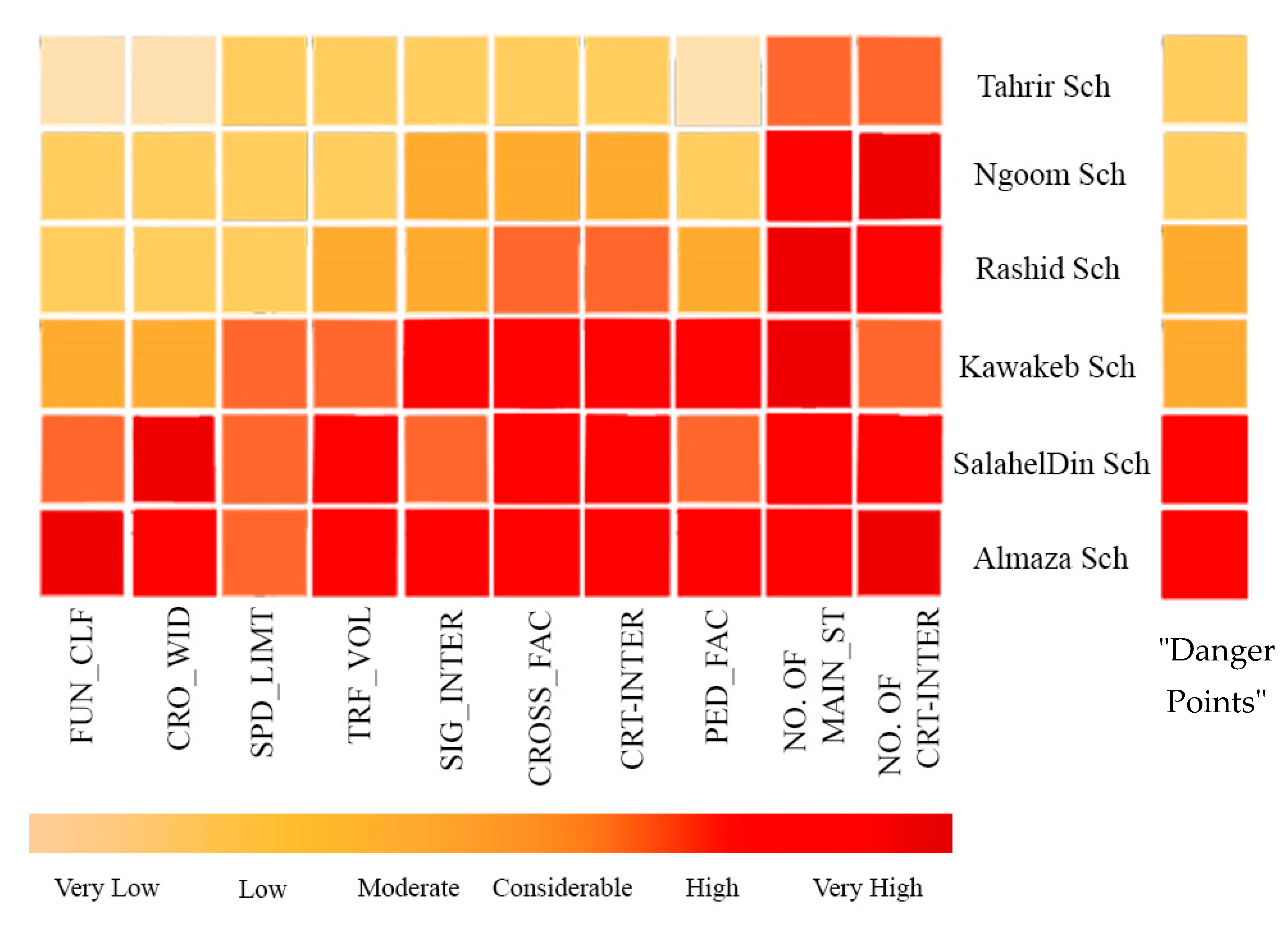
Table 1—later used in risk assessment—and represent the compilation of all observations gathered during each observation session.
The second method used was a brief survey of children between the ages of 7 and 12 years old belonging to these schools, in order to ascertain their different modes of journeying to and from school, and their perceptions of safety along the daily trip. The surveys of the children were completed in their schools. The researcher described the study’s overall objectives and how to complete the questionnaire. After that, the children completed the surveys on their own. The researcher addressed any specific inquiries and, if required, assisted the younger children in filling out the questionnaire. It was agreed, in cooperation with the heads of these schools, to send out parent surveys via mail. Parents could also fill out a survey on the internet, in addition to some semi-structured interviews to reach parents who could not receive the mail. The parents’ survey focused on their engagement in their children’s travel, as well as their opinions and worries regarding their children’s independent mobility outside of the home. The main objective of both questionnaires was to assess children’s independent mobility through the examination of six levels of independent mobility, as examined in two British studies [
33] (1) license to come and go from school alone; (2) license to cross streets; (3) license to use public transport; (4) license to cycle on the streets; (5) license to go on their own to places other than school; and (6) license to go out after dark. Data collection took place from September to November, 2020. Interviews with teachers in the schools were also carried out. The questionnaires were developed based on experiences from other questionnaires and literature within the field. All of the questions were written in both Arabic and English, with approximate descriptions for issues like distances, busy streets, etc. The two questionnaires were divided into three main parts related to children’s/parents’ information, transport modes to school, and perception of safety, in order to define the problems observed and investigate the current situation through children’s and their parents’ perceptions of their neighborhood.
To have a clearer understanding of these children’s current situation, data were gathered and analyzed. Then, using a risk assessment framework, a methodology for reliably and fairly assessing hazards along the routes to schools was developed to determine the possible risks to child pedestrians, as shown in
Table 1. This methodology was created utilizing technical guidelines on defining “hazard zones”, in which school bus services should be offered in order to address traffic safety problems, in various states across the United States. Similar parameters for measuring pedestrian safety are used in the majority of approaches, including: traffic volume (both along roads and at intersections), speed limit, type of intersection control, size and function of the road—e.g., width, number of lanes, functional classification—and type of pedestrian facility provided along the road, e.g., sidewalk, shoulder, etc. This approach aims to determine schools that require immediate attention in order to address the difficulties that have developed as a result of Heliopolis’ street expansion.
Both the parents and the children were told about the research, including what would happen, what the child would be expected to do, that the child could consent or refuse to participate—with no negative consequences—and that the child could withdraw at any time. It was also presented in simple language that the children could understand. With the help of social work teachers, parental consent was obtained for their children to participate in the research.
3.4. Data Analysis
Firstly, the data from the maps and surveys were used to determine the following: The first section deals with the journey to and from school, in order to obtain a better understanding of how children travel to and from school, and a description is given of parental licenses of independent mobility for primary school children. The second section gives an account of children’s and parents’ perceptions of safety in their local neighborhood. The final section tackles other factors that can affect children’s independent mobility, such as age, gender, car availability, social class, and areal characteristics.
Secondly, the risk assessment framework provides details for assessing the traffic hazards that pose a barrier to children walking to school. Although its primary purpose is to assess risks, the safety system also provides a basis for prioritizing improvement of the walking environment, where there are traffic safety hazards that make walking to school difficult for children.
The majority of approaches employ technical guidance on identifying ”hazard zones”. They have comparable criteria for assessing pedestrian safety, such as speed limit, traffic volume (both along streets and at intersections), type of intersection control, and size/function of the street; e.g., width, number of lanes, functional classification, etc. This is based on a framework that draws on extensive safety research and commentary on similar assurance systems in the United States [
34]. Collection orders take into account the cumulative effect of multiple hazards along the way to school. To implement the addition order, “danger points” are set. When the risk has a score of five or more, the risk is considered high. To support decision-making, the tool provides a quantifiable framework for determining child pedestrian safety.
4. Results
In this study, children and their parents answered a questionnaire about the level of independent mobility and the perception of safety in their primary school age children. Clear age differences were apparent—license to go home from school alone, to cross busy streets, and to use public transport increased with the children’s age. Based on parents’ opinions today, after street modifications, most children were not allowed to do these things until around the age of 13, i.e., enrolled in the middle school. Moreover, this is also the case when it comes to cycling on busy streets, where the majority of children are not allowed to cycle until the age of 15. However, their parents said that they used to cycle in the past from the age of 10 or less. Among the children themselves, half think that they are allowed to do so at the age of 10, confirming what their parents said. When it comes to parental permissions for independent mobility, there are significant differences between boys and girls. Girls are given less permission to cycle or go out alone, while boys are given slightly more permission to go out and cycle.
The most common ways of travelling to school, according to the questionnaire, are either by public transportation (30%) or in a small van or private bus (42%). Fewer children walk to school today, particularly among younger children (
Figure 8). More than half of the children wanted to walk or cycle to school, and their parents also believed that cycling had decreased (
Figure 9).
The children who travelled by public transportation/car were the least satisfied with their mode of transport: 30% were satisfied, but many would prefer to cycle, and 60% would prefer to walk. This may also point to the fact that the children want their schools to be situated within walking or cycling distance. Most of the children, except for those in local schools, like El-Tahrir School and El-Ngoom School, have to cross many streets in order to get to school.
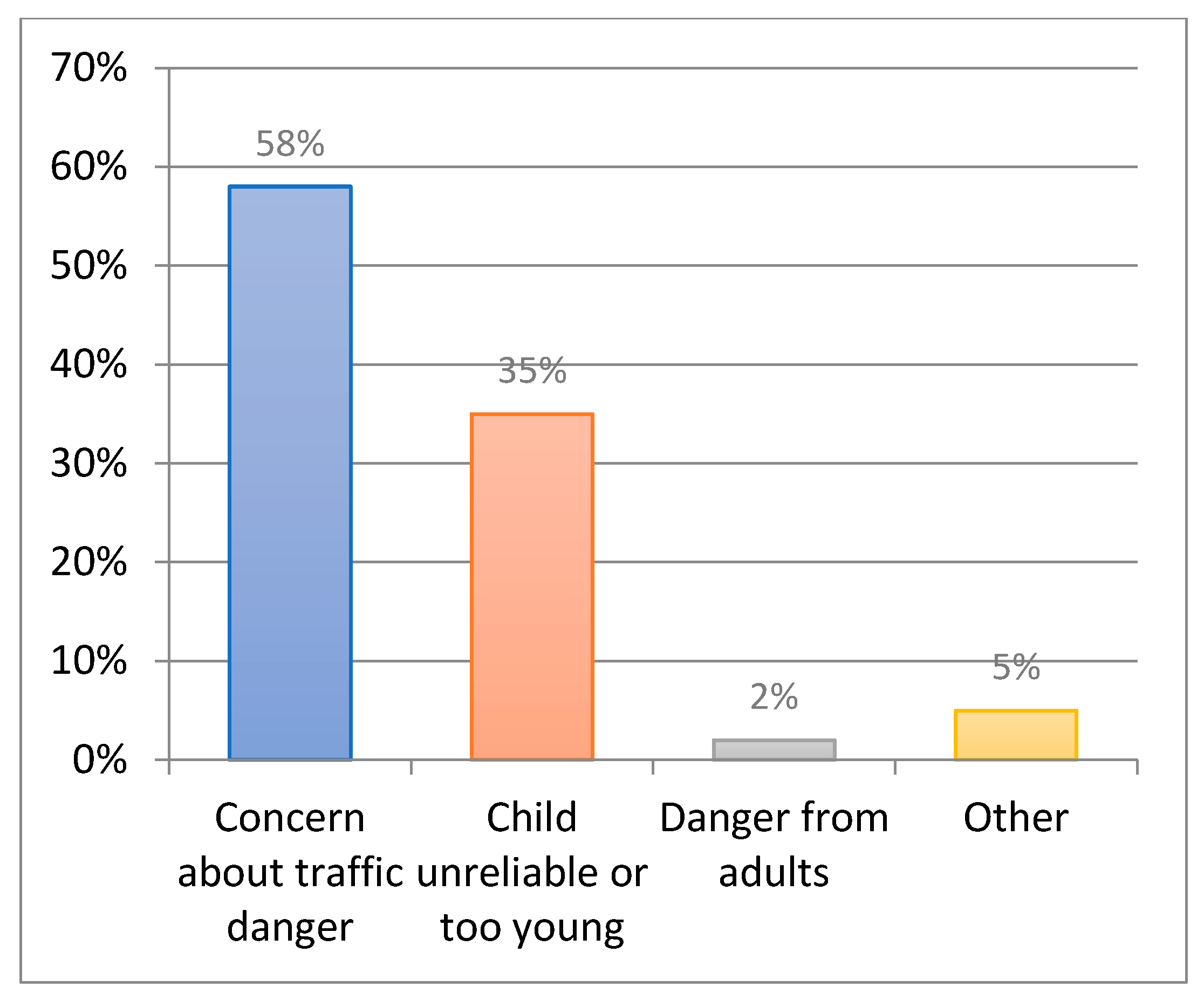
The parents feel that it is safer to drive their children either by themselves or by subscribing to a private bus service to transport the children to school, because they do not want their children to be walking and crossing the streets on their own (
Figure 10). The children must cross several streets, and even if there is a footbridge, the children will want to go via the shortest route, i.e., across the street. However, several parents who were interviewed also thought that children walk less far on their own today than in previous generations, when they could walk several kilometers. Only a small percentage of parents were driven to school when they themselves were aged 7–12.
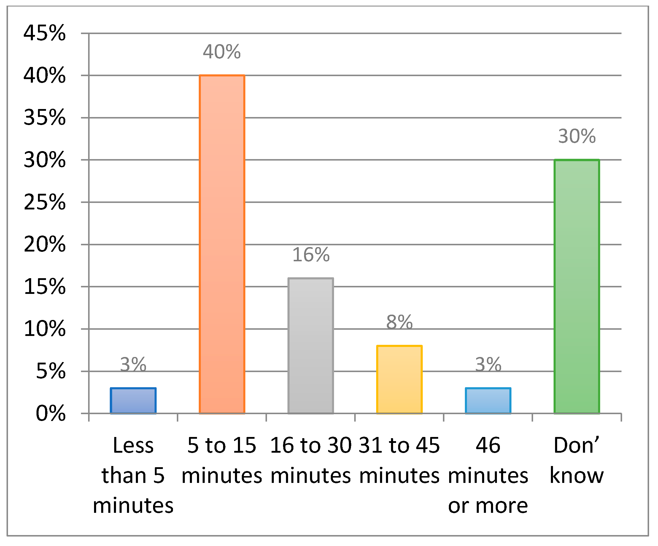
Fewer children walk to school alone or with a friend today. Seventy-two percent of primary school children are accompanied to school by an adult. Younger children usually walk with a parent or are driven to school, while older children travel by public transportation or walk alone. Forty percent of the children get to school within 15 min (
Figure 11). The children who walk or travel by private bus/car have the shortest journey times, while those who take public transportation spend more time getting to school.
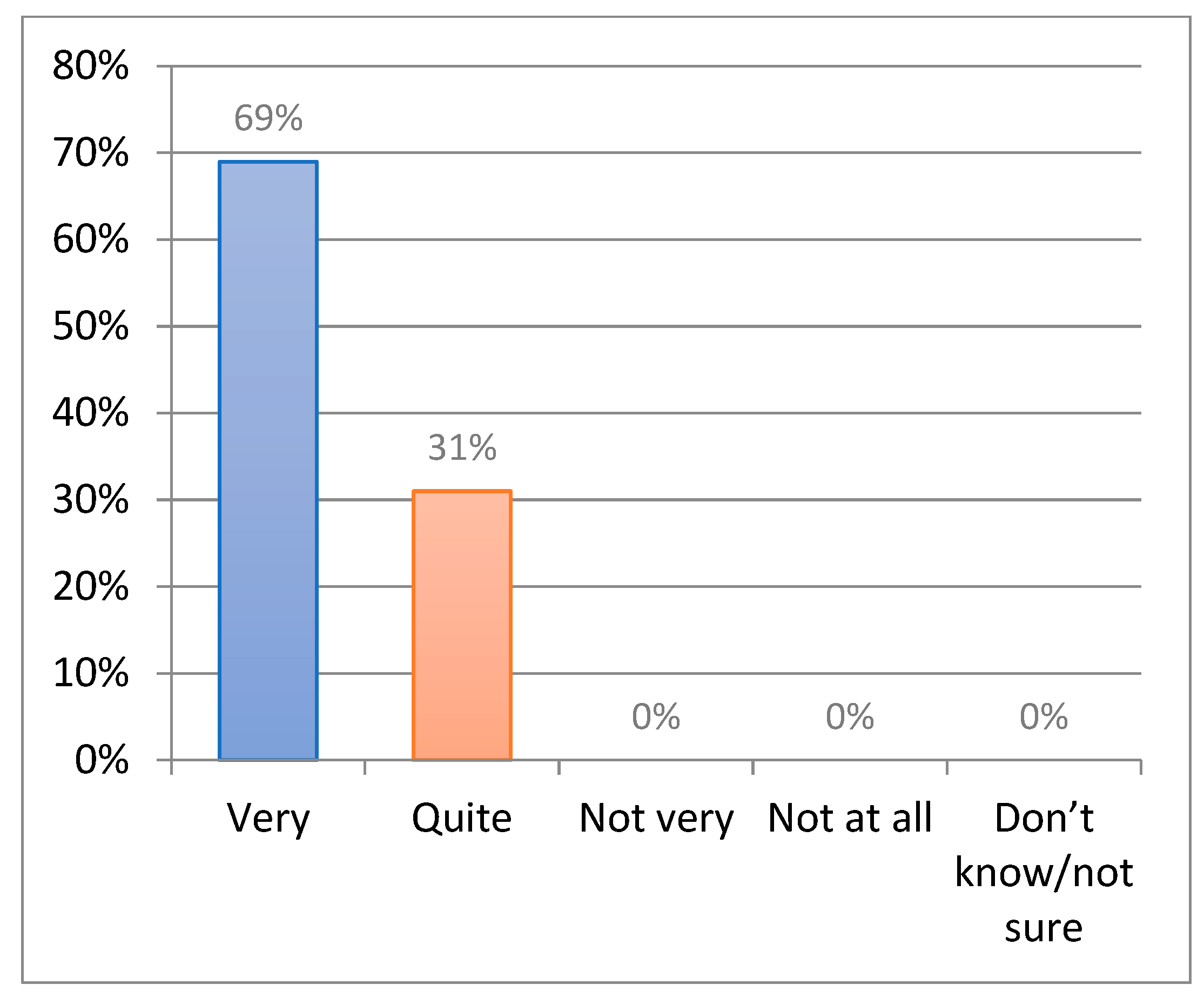
Almost all children (76%) did not feel safe or feel fairly safe when outdoors in their local neighborhood without an adult. Few children were worried about strangers compared to those who were worried about traffic; 69% of the children expressed anxiety about crossing streets (
Figure 12). Boys were less worried than girls. Girls were more worried about getting lost and bullying compared with boys. Parents were also worried about traffic; nearly four in five parents were very worried that their child might have an accident when crossing a busy street. Parents of younger children were more worried than parents of older children. In the inner schools El-Tahrir, El-Kawakeb, and Rashid, the parents also confirmed that the traffic around these schools is chaotic; particularly in the mornings when the children are starting school, there is heavy through-traffic and queues (
Figure 13).
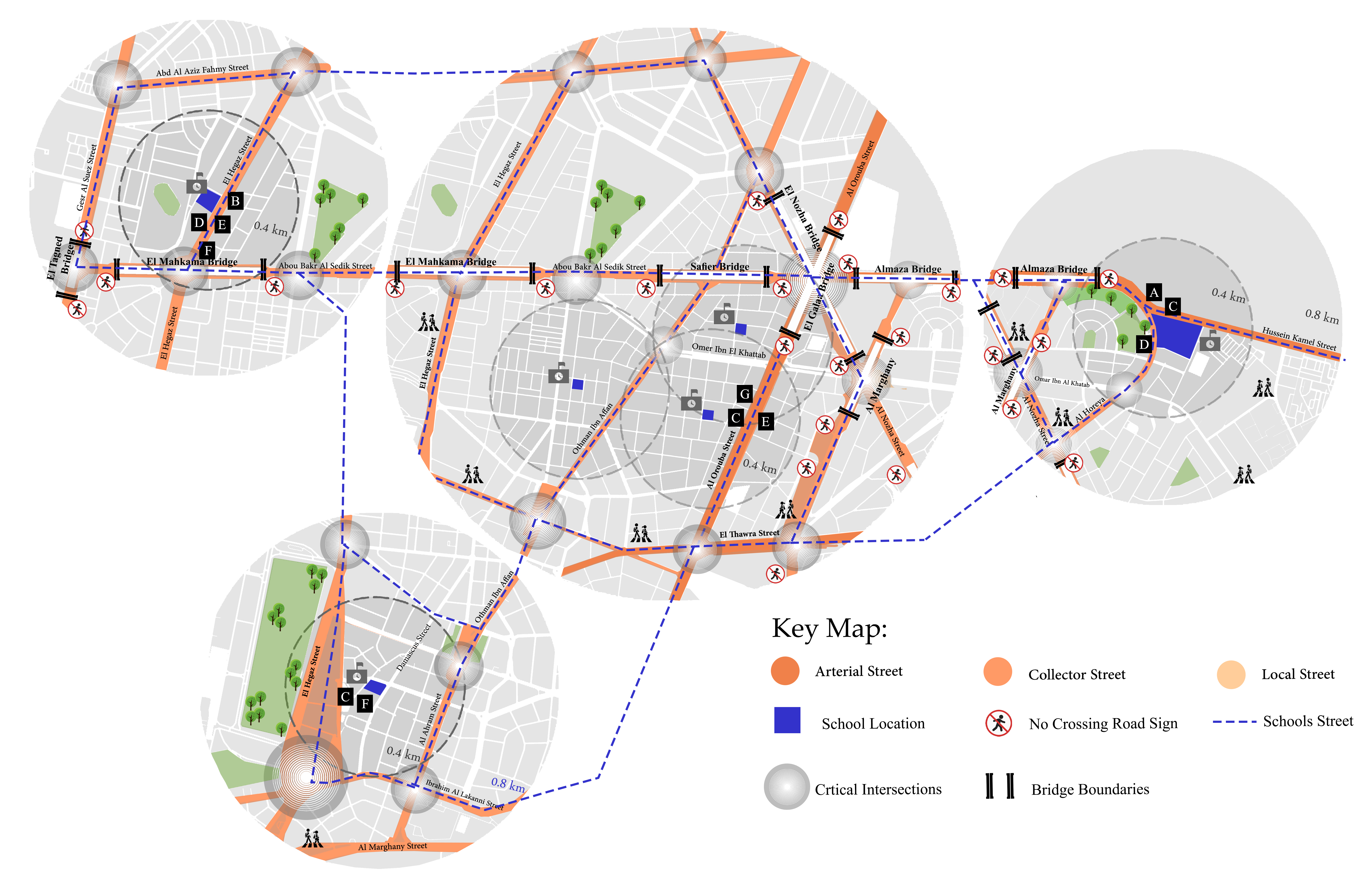
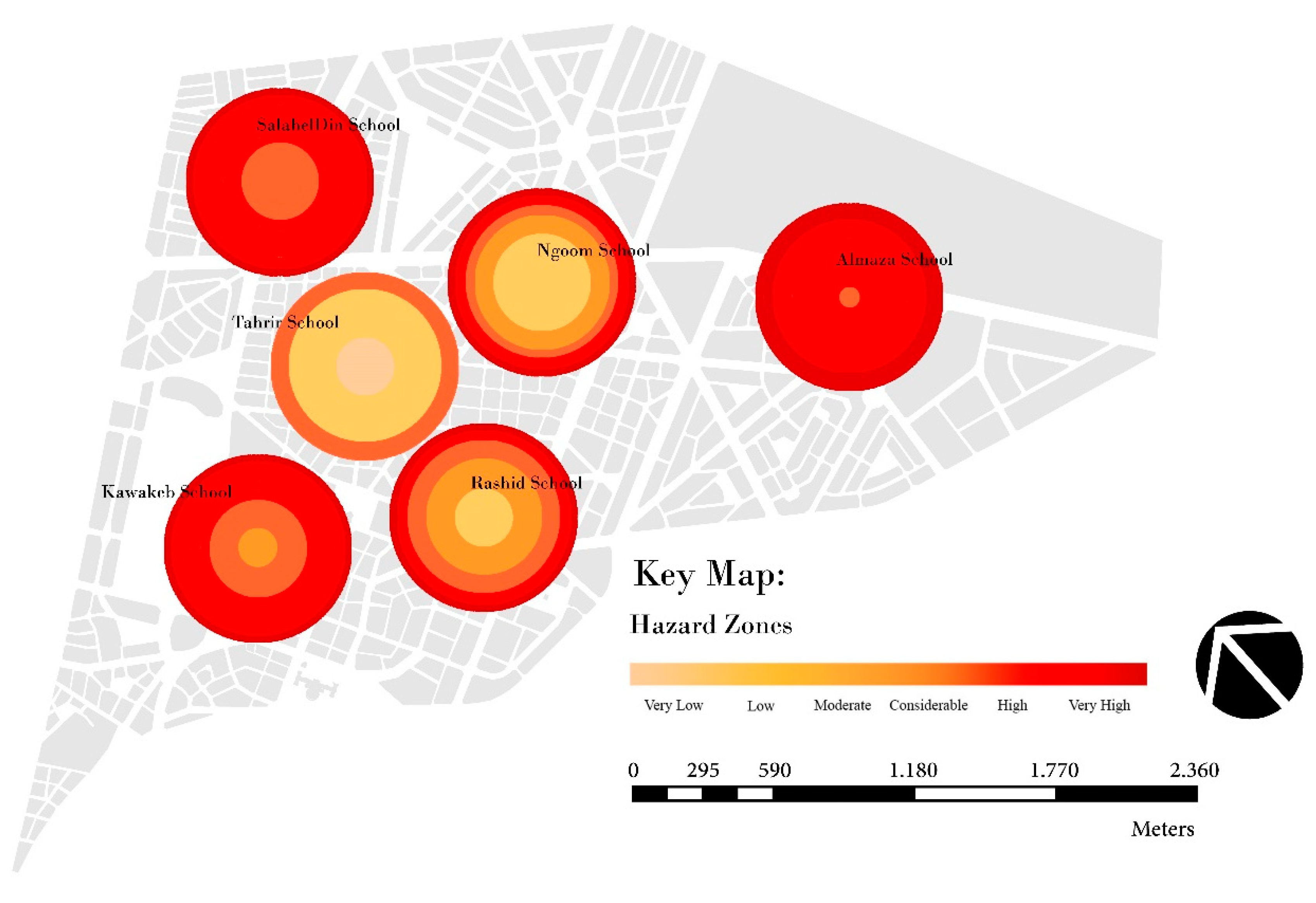
Figure 14 shows a behavioral map of Heliopolis, showing six primary schools, and the areas surrounding them, in which the street modifications took place. Challenges crossing the street, traffic, and busy streets were all safety-related barriers. One child described crossing the street near the Almaza school, saying “
In the mornings, it’s really crowded, with many cars—I almost got hit there. It is used as an intersection; I believe they should put a stop light there.” (
Figure 14-A). Another student expressed similar fears about crossing the street while on his way to school, stating that “
I can’t cross the street in the morning because the drivers don’t always stop to look while walking to school, so I don’t feel safe when I cross and when the cars stop because they don’t always stop, and some cars don’t stop at all.” (
Figure 14-B).
On their way to school, students felt insecure and unsafe due to the width of the crossed streets, the number of vehicles, the speed of traffic, and the noise created by traffic, with a large number of students making comments such as, “
The traffic terrifies me.” (
Figure 14-C); “
After widening the street and with so many cars here, I can’t cross the street.” (
Figure 14-D); “
The street is very wide in both directions and I have to stand in the middle of the street several times, this makes me scared because of the fast-moving cars” (
Figure 14-E); and “
Right now, it’s dangerous because there are so many cars.” (
Figure 14-F). Some features presented hazardous street scenarios, creating a sense of insecurity.
When one student said, “
I fear walking to school and crossing the street” (
Figure 14-G), he summarized the majority of participants from all schools’ perspectives. The children observed drop-off areas, which are most likely in front of the school door, as unsafe, chaotic, and hazardous, mainly in the morning because of the increase in traffic. Additionally, many children said that their parents’ concerns about their safety prevented them from walking to school. Furthermore, many children felt as though their parents didn’t feel that they were old enough to walk on their own. As a result, many of them were transported by car, or a different mode of transportation.
After completing the behavioral map of the six primary schools and the areas surrounding them, in which the street modifications took place, there are 10 factors used as principal measures of the independent mobility of the children, studied through identifying the potential risks involved in the journeys. Comparing scores in
Figure 15 below gives further insight into which schools perform better or worse in comparison with one another. The results show us that Almaza Primary School and Salah El-Din Primary School face many challenges (
Figure 16).
5. Conclusions
City planning affects new generations, as it is the main feature of their perception of the built environment when they grow up. Urban design influences children’s behavior through experiences related to distance, social and environmental quality, the travel environment, and transportation facilities. It is the experienced meaning of the environment induced by design elements that potentially impact behavior, such as the experienced nearness, traffic safety, and incentives to walk, cycle, drive a car, or play outdoors. However, unfortunately, what happened to Heliopolis encouraged the greater use of vehicles. This contributed to a driving-oriented environment that has resulted in a high number of traffic accidents each month since August 2019. Parental anxiety regarding traffic safety has grown, causing many parents to restrict their children’s independent mobility and activity outside. Expanding the streets to that width, without any possibilities for safe pedestrian crossings, will counter any benefits gained by expanding the streetways, and will increase the number of trips taken by private cars/buses. Hence, people are not just commuting to work, but have to move around the neighborhood for purposes that didn’t require motorized mobility before, such as children going to school.
After street modifications, access to neighborhood schools in Heliopolis, Cairo is affected by children’s levels of independent mobility. With the increasing numbers of children being chauffeured to school and other activities, there are fewer children walking around their neighborhoods freely and independently. This is combined with a loss of incidental physical activity, informal play, and social exchange with other children, as well as a lack of belonging and spatial understanding of their neighborhoods. The overall decline in children’s independent mobility and feeling of safety emphasizes that children today are much more restricted than children in previous generations.
All governments that have signed the Convention on the Rights of the Child should perform analyses of the impact on children of all decisions affecting children, according to the UN Committee on the Rights of the Child in Geneva. However, the Egyptian Transport Administration does not perform analyses of the impact of children on road development projects, although it is one of the member states of the Convention. According to the findings, responsible authorities should engage children and young people and keep them informed so that their perspectives may be considered before making decisions.
This paper reports on an assessment framework that was developed for some primary schools in the Heliopolis neighborhood to assess the need for fast interventions to address traffic safety concerns. The study focused on the most important schools that expose their students to risks; for this reason, it was recommended that Heliopolis municipality test the methodology at several schools and carefully review the assignment of hazard points in order to ensure that the results accurately reflected the perceived level of risk as determined by the research.
There were limitations to this study in that, although the questionnaire was initially tested and found to be clear and appropriate for the age range of students involved in the study (primary school), some terminologies were still more understandable for older students, and some requirements—such as reading/writing tasks—may be better completed by older students. Furthermore, because the survey was completed in the classroom, it is possible that the participants were biased to give “good” or “desirable” responses in order to satisfy the researchers.


