
The Evolution of Urban Planning in Medium-Sized Catalan Cities (1979–2019)

Department of Geography and Sociology, University of Lleida, 25003 Lleida, Spain
Urban Sci. 2021, 5(2), 36; https://0-doi-org.brum.beds.ac.uk/10.3390/urbansci5020036
Submission received: 19 February 2021
/
Revised: 12 March 2021
/
Accepted: 16 March 2021
/
Published: 13 April 2021
(This article belongs to the Special Issue Fragmented City: International Mobility and Housing in Spain)
Abstract
:Urban planning, as well as the type of city in which it takes place and is promoted, has changed a lot in Spanish cities since the return to democratically elected municipal governments in 1979. This work seeks to characterise the transformation that urban planning has undergone over the last 40 years. It sets out to do this by studying the cases of two medium-sized Catalan cities, their underlying city models, and the ways in which planning has been defined and managed in Catalonia. All of this was undertaken through a bibliographic and documentary analysis of the approved planning documents, which was accompanied by a study of the population dynamics and building cycles. In Spain, urban planning has been one of the instruments used to catalyse expectations for economic growth based on land consumption through urbanisation. Within this context, planning has progressed from fulfilling an initial requirement to regulate activities and urban growth (1979–1991) to facilitating urban development through a clearly expansive and speculative form of neoliberal urbanism (1993–2007) and, finally, to assuming a form in which these previous tendencies coexist with certain new orientations.
1. Approach, Objectives, and Methodology
As several other works have already highlighted, since the mid-20th century, in Spain, there has been a strong connection between economic growth and that of the building sector. At times, this has appeared to be so close that it has even led some authors to speak of Spanish property capitalism [1,2]. There is little doubt that this has produced an expansive, speculative, and unsustainable urban model and has resulted in a frenetic rhythm of urbanisation [3,4].
Urban planning and development have been the main instruments used to catalyse expectations for economic growth, and are almost exclusively based on the consumption of land [5]. This has occurred at a time when the expectations for capital gains generated by urbanisation have proved greater than those associated with any other form of economic activity [6]. The city and the production of urban products have therefore become a mechanism for the absorption of capital surpluses for their subsequent integration within the circuit of accumulation [7,8].
This article suggests the existence of a relationship between the characteristics of urban planning, the models of urbanisation that underlie them, and the resulting urbanisation processes. To demonstrate this, we have outlined the main proposals and approaches of the urban Master Plans of two medium-sized Catalan cities—Lleida and Manresa—and analysed their development and the dynamics of their urbanisation and growth.
These case studies were selected based on the following criteria: Firstly, both of the cities studied have a certain demographic size, perform the function of being local capitals, and play a significant role in the territorial articulation of their respective areas of inland Catalonia; secondly, in Catalonia, great efforts have been made to review urban planning procedures in this kind of city since the transfer of competencies relating to urban planning and its regulation from Spain’s central government to the autonomous regional government in 1978; and, thirdly, both municipalities—Lleida and Manresa—have had three different Master Plans approved since the first democratic municipal elections held in 1979. These make it possible to characterise the evolution of urban planning in these cities during different periods of Spain’s recent democratic history.
To establish the context, we shall first characterise urban planning in Spain and Catalonia through a bibliographic and documentary analysis, which will be cited in the second section of this article. For this analysis, we established three different periods: 1979–1991, 1992–2007, and 2008–2019, as shown in Figure 1. This delimitation is based on the evolution of the dynamics of the real estate cycle [9].
To study urban planning in Manresa and Lleida, we consulted the local urban planning archives of their respective provinces (Barcelona and Lleida), where we examined the different Master Plans and all relevant approved planning documentation since 1979. Data were also obtained from the Censuses of Population and Housing issued by Spain’s Instituto Nacional de Estadística (INE—National Institute of Statistics) for the years 1981, 1991, 2001, and 2011, and from the Padrón Municipal de Habitantes (Local Population Register) of 2019. This information was also used to help us illustrate the growth dynamics of these municipalities and their respective urban areas.
Following the approval of the Spanish Constitution in 1976, there was a process of decentralisation of competences relating to regional planning, urban planning, and housing, with these being transferred to the different Autonomous Communities [10]. This has since resulted in the development of seventeen different frameworks for urban planning policy. Despite certain formal differences, and as previously noted in several other comparative studies [11,12], these remain similar—in both content and structure—to the system that was proposed under the national Land Use and Urban Planning Act, which was passed in 1976 (Royal Decree 1346/1976, of 9 April).
The Land Act of 1976 established a hierarchical structure of municipal planning instruments, amongst which it is possible to highlight the following characteristics:
- -
- Master Plans (the Plan General, Plan General de Ordenación, or Plan de Ordenación Urbanística Municipal). The Master Plan is the key element in Spanish urban planning, as it defines the model for urban evolution and land use within a given municipality. The Master Plan is an instrument for integrated urban planning within the municipality. It classifies land, defines the general urban structure of the territory, and presents a programme for its development. It is also a key document for establishing the legal status of land, and has important implications within property law (establishing faculties for its use, enjoyment, and exploitation).
- -
- The Master Plan contains a classification of all the land in the municipal area. It makes distinctions between: Suelo Urbano (urban land), which is the urban area that has already been more or less urbanised and built upon; Suelo Urbanizable (land zoned for development), which is land that could potentially be developed and which could be classified as either sectorialised or delimited (whose development requires the approval of a Plan Parcial (Partial Plan)), or as non-sectorialised or non-delimited land (which requires a much longer bureaucratic process); and Suelo No Urbanizable (land not zoned for development), or rustic land, which is land that cannot be developed and/or which is incompatible with urban development.
- -
- Different figures involving more detailed planning proposals can be used to develop the Master Plan. The most significant of these figures are: Planes Parciales (Partial Plans), Planes Especiales (Special Plans), and a number of other plans of more limited scope. The Plan Parcial is the key instrument used for developing Suelo Urbanizable (land zoned for development): the land that the Master Plan classifies as being suitable for urban development. This is the first step in the process of transforming rustic land into urban land.
Another figure characteristic of the planning derived from the Master Plan is the Plan Especial (Special Plan). This is the most appropriate figure for undertaking interventions (whether involving reform or improvement) within the existing city. Special Plans are also appropriate instruments for protecting unique settings: historic centres, spaces of historical and artistic interest, and spaces of natural, environmental, or scenic interest, amongst others.
2. The Evolution of Urban Planning in Spain and Catalonia: 1979–2019
Despite the existence of certain differences in the urban planning policies carried out in different Autonomous Communities since the transfer of competences from the central government, there still exists a general Spanish framework [11,12]. In this section, we shall contextualise and characterise the evolution of urban planning from the time of the first democratic local councils (1979) through to the present day. We shall also explain the changes that have occurred in the city model on which urban planning was based in the different periods that we have previously identified.
2.1. The Revision of Previous Planning and the New City Model Associated with “Urbanismo Urbano” (1979–1991)
The first of our periods extends from the time of the first democratic elections for local councils—in 1979—until 1992. The newly elected municipal councils faced the task of defining new municipal agendas within which urban planning was to play a central role. They began to revise their Master Plans in a task that went beyond simply adapting them to the precepts of the new Land Act of 1976. Local councils took advantage of this situation to change the focus of the model and the contents of their Master Plans, revising any building ordinances and norms that could be considered speculative or that had been based on previous over-dimensioned expectations for growth. The new documents gave priority to restructuring, reforming, and improving the existing cities through a type of urban planning that was described as urbanismo urbano—literally, “urban” urban planning [13]. In this way, general urban reform and transformation were imposed in an attempt to offset the disproportionate growth of the previous period.
In Catalonia, following the transfer of competences in 1978, the corresponding Department of the Generalitat de Catalunya focused its attention on revising the existing Master Plans and drafting new ones. As a result, during this period, a large number of Master Plan documents were passed, whose contents clearly differed from those of the 1960s and 1970s. New planning documents expressed a willingness to face up to the main urban problems that had been inherited from the previous period. They also offered a way to increase urban provisions and to put an end to the previous process of “desarrollismo” (excessive urban growth promoted during the final decades of dictatorship) [13].
The first step towards achieving this involved changing the status of land and reducing the amount of land classified as Suelo Urbanizable (land for urban development), much of which became either Suelo Urbanizable no delimitado (non-delimited land, which required a much longer bureaucratic process before it could be developed) or Suelo no Urbanizable (land not zoned for development). Secondly, not only was the quantity of land to be developed reduced, but also its densities and buildable areas. This downward shift in densities also applied to the Planes Parciales, which were used to develop the land classified in Master Plans as Suelo Urbanizable and were submitted for approval or had already been approved.
When it came to classifying new land for urban development, these proposals offered a new way to complete the urban structure and to integrate semi-consolidated urban areas. Furthermore, much of the zoning, which had often been very general and inappropriate for its location, was revised, as were the maximalist building ordinances. Finally, there was a general increase in the amount of land set aside for urban amenities and open and green spaces.
In the management and deployment of new (or revised) Master Plans, the most significant planning figure was the Plan Especial, whether for urban reform, improvement, or protection. Its special importance derived not only from the great number of documents drafted and approved in Catalonia, but also from the fact that it became one of the figures that best reflected the aim of the urban planning and policies undertaken during this period. Its main objectives were to make improvements to and to reform the existing city, and also to protect its historic centres and areas of natural interest. Even so, the characteristics and nature of these documents were set to change when what started as (often rather ambitious) social projects were later converted into more formal and architectonic projects [14].
Furthermore, with attention moving to the more or less consolidated city, insufficient attention was given to the protection of spaces of special (environmental, natural, or scenic) interest, to the protection of vulnerable spaces on Suelo No Urbanizable (land not zoned for development or rural land), and to supramunicipal coordination. All of that was needed at a time when processes of suburbanisation and peri-urbanisation were in full swing in the metropolitan areas, and they were also starting to emerge in the spaces surrounding medium-sized cities in the most dynamic territories [15,16].
2.2. Speculative and Expansionist Urban Planning Associated with the Property Boom (1992–2007)
During the second period, between 1992 and 2007, there were notable changes in Spanish urban planning. On the one hand, these were associated with the new socioeconomic and financial context; on the other, they owed much to the widespread application of neoliberal policies [4,17].
The most important legal changes that occurred during this period were the result of the deregulation of the mortgage and land markets as a consequence of the amended Land Use and Assessment System Act: Law 6/1998 [18]. This soon became popularly known as the “law that allowed everything to be developed”, as it effectively allowed any land that was not expressly protected to be potentially available for urban development.
Instead of regulating urban growth, urban planning used all its available resources to encourage and exacerbate urban production. The city and its surrounding territory were converted into both the subject and object of accumulation through the classification of large swathes of municipal terrain as Suelo Urbanizable and continual modifications to the previously approved planning regulations [3,19].
Furthermore, the traditional regulatory role of urban planning was relegated to a secondary position, while pride of place was afforded to strategic planning and the development of large-scale urban projects. This expressly implied renouncing the definition of a specific model for both the city and its territory [20,21].
In Catalonia, a second generation of Master Plans was drawn up under the new Urban Planning Law—2/2002 [22,23]. These Master Plans, which were mainly passed in the 1990s, did not result in any great changes in either the approach to urban planning or the nature of its documents, but heralded the introduction of several new visions, amongst which we can highlight the following:
- -
- The city, or urban area, tried to connect certain proposals (regarding the structure and organization of the nuclei and their respective transport systems, housing, open-space areas, public amenities, etc.) by introducing wider regional (and supramunicipal) considerations. In Catalonia, from 2004 onwards, one of the most important lines of spatial planning specifically focused on deploying regional planning at the supramunicipal scale: Partial Territorial Plans (Plans Territorials Parcials, in Catalan). These plans were approved with the intention of preserving natural and landscape assets and controlling urban growth at the subregional intermediate scale [24,25].
- -
What has come to be called the urbanising tsunami, or the prodigious decade of Spanish urbanism (1997–2008), was publicly encouraged by urban planning legislation, management, and fiscal and economic policy, and was dependent on sources of local finance [27,28]. The causes and consequences of this unique form of urban and property expansion have already been examined in numerous other works [3,4,27,28,29,30], amongst others). The only reflexion that we would like to add here is the following paradox: The greatest urbanisation process, and the most speculative one in Spanish urban history, coincided with the moment of the greatest urbanistic and territorial regulation.
The legacy of this period was one of Master Plans with provisions for unconstrained growth, poorly integrated and over-scaled urban projects, and—above all—great urban voids with land that had been prepared for urban development and construction but was not consolidated. This was a pattern that was repeated and spread across the length and breadth of the country. Indeed, it is one that still persists today, particularly in large areas of the interior of the Iberian Peninsula, where many landscapes reflect the bursting of the property bubble, whose consequences have lasted until today.
2.3. The Changes of Post-Crisis Urban Planning: The Exploitation of More Centrally Located Capital Gains (2008 Onwards)
After the excesses came the National Land Law 8/2007 of 28 May 2007, which consolidated the Land Use and Urban Planning Act. Even so, this arrived late and was insufficient for what it was meant to correct. Amongst other questions, this law established that it was only possible to classify as Suelo Urbanizable that which was specifically required to meet the needs that justified its urbanization, it protected land owners from promoters undertaking transformation projects, and it increased—to a minimum of 30%—the amount of total residential building destined for social housing. With the arrival of the property crisis in 2007, there was a change in the property cycle and in the focus of urban planning towards the inner areas of the city. Faced with the impossibility of continuing with the previous logic of land development, post-crisis urban planning brought a change in the expansive urban model. It was in this context that the first period of discourse of “urbanismo urbano” also reappeared. Some of the first consequences of these new visions were revisions of previous excessive provisions for Suelo Urbanizable that were contained in inherited Master Plans.
Attention now returned to urban land and to more centrally located areas in an attempt to exploit potential capital gains through small-scale interventions. This change was reflected in the generation of new Master Plans, which now contained interventions in urban centres that included a level of detail that was almost on a par with that of an intervention project.
These central interventions were also promoted by Law 8/2013 on Urban Rehabilitation, Regeneration, and Renewal, which was popularly known as the “3Rs Law”. After the crisis, the new property development strategies abandoned the previous grandiose operations on the urban periphery and sought, instead, to undertake development projects based on rehabilitation and renewal in the inner parts of cities [31]. This implied a number of functional changes as well as changes in the socioeconomic profile of the population [32]. At the same time, some large-scale projects were recovered, especially following the slight recovery of the property market that occurred in 2016. This helped to consolidate cities that had been fragmented, deprived, and colonised by financial capital [30,33].
Meanwhile, and from 2008 onwards, a set of spatial planning tools were also approved in Catalonia. The aim was to manage urban growth based on a physical planning approach and to preserve natural values and the landscape. In fact, most of the Partial Territorial Plans, as well as the land-use planning applied at the subregional scale, were approved in this period. Moreover, after the Catalan Landscape Act of 2005, seven landscape catalogues that identified the most important natural and cultural values and proposed a set of basic guidelines for their preservation were approved.
Unfortunately, the planning apparatus of this period arrived late, and this could be interpreted as a means of validating autonomous urbanization processes once they had been consummated.
3. Lleida and Manresa: Territorial Context and Dynamics of Population Growth and Housing
Manresa is a municipality with an area of 41.66 km2 and a population of 77,714 [34]. It is the capital of the comarca (local district) of El Bages in the province of Barcelona. It stands on a plain located within the central depression of Catalonia, and its urban development has been shaped by the rivers Llobregat and Cardener and by the surrounding uplands. The economy of Manresa and its urban area is based on historic industrialisation, and the city currently houses the largest concentration of specialised services and amenities in central Catalonia. The urban area around Manresa delimited by the Ministerio de Transportes, Movilidad y Agenda Urbana MITMA [35] is relatively small (Figure 2). Manresa had a population of 104,947 in 2019, with a surface area of 96.9 km2. Its metropolitan area includes four municipalities: Manresa (77,714 inhabitants in 2019), San Joan de Vilatorrada (10,936), Sant Fruitós de Bages (8703), and Santpedor (7554). As shown in Table 1, over the last decade, Sant Joan de Vilatorrada—which practically forms a conurbation with Manresa—Santpedor, and Sant Fruitós de Bages have all grown more than the municipality of Manresa itself.
The case of the urban area of Manresa is of interest for a number of reasons. Firstly, this is one of the areas in Catalonia with the longest histories of urban planning at the supramunicipal scale. The Pla Director Urbanístic del Bagès (PDU El Bages, 2006) is a supramunicipal urban plan that covers a total of 27 different municipalities around Manresa. It has been used to guide and coordinate local planning in response to notable transformative dynamics and to find solutions to the problems faced by this area, as well as those related to the infrastructure and open spaces located within this territory. The proposals and instructions contained in the PDU of El Bages were later included in the corresponding Regional Plan, the Pla Territorial Parcial de les Comarques Centrals (PTPCC) of 2008, and were developed through the Pla Territorial General de Catalunya (PTGC). It is interesting to study Manresa because it has passed three Master Plans since 1979, and thus allows us to analyse the evolution of different generations of this kind of plan [37].
Lleida, on the other hand, has a surface area of 212.30 km2 and a population of 138,956 [34]. It is the service capital of an extensive area, with a notable degree of specialisation in the agricultural and agro-industrial sectors, and is located on the Lleida plain in western Catalonia. The urban area of Lleida, which is notably larger than that of Manresa, has an area of 426.3 km2 and includes eight municipalities with a total population of 169,620 (2019), 81.9% of which lives in the central municipality of Lleida (Figure 2). According to the MITMA Atlas [35], the other municipalities in this area are: Albatàrrec (2221), Alcarràs (9514), Alcoletge (3420), Alpicat (6255), Artesa de Lleida (1504), Rosselló (3145), and Torrefarrera (4605 in 2019). As in the case of Manresa, the relative growth of the population, housing, and urbanised land in the neighbouring municipalities has been noticeably greater than in the central city. In fact, some have already become conurbations in their own right, as in the case of Alpicat and Torreferrera.
The municipality of Lleida, as well as its urban area in general, enjoys excellent connectivity via high-capacity transport infrastructure. In contrast, it has less experience than Manresa in supramunicipal and regional planning. The Pla Territorial Parcial de les Terres de Lleida was passed in 2004 and, to a certain extent, has since conditioned the growth of the municipalities in its immediate vicinity by promoting the city of Lleida as the main pole in the territory. As in the case of Manresa, the municipality has had three General Urban Plans since the restauration of democracy [38].

Table 1.
The dynamics of population growth and housing in the municipalities and urban areas of Manresa and Lleida [39].
Table 1.
The dynamics of population growth and housing in the municipalities and urban areas of Manresa and Lleida [39].
| Population | Dynamics of Annual Population Growth | Housing Units | Dynamics of Annual Housing Growth | ||||||
|---|---|---|---|---|---|---|---|---|---|
| 2019 | 1981–1991 | 1991–2001 | 2001–2011 | 2011–2019 | 2011 | 1981–1991 | 1991–2001 | 2001–2011 | |
| Municipality of Manresa | 77,714 | −0.1 | −0.4 | 1.9 | 0.2 | 39,605 | 0.9 | 1.7 | 2.1 |
| Manresa Urban Area | 106,926 | 0.3 | 0.1 | 2.1 | 0.3 | 51,530 | 1.1 | 2.0 | 2.5 |
| Municipality of Lleida | 138,956 | 0.5 | 0.0 | 2.2 | 0.2 | 66,415 | 1.5 | 2.4 | 1.6 |
| Lleida Urban Area | 169,620 | 0.5 | 0.2 | 2.8 | 0.3 | 79,825 | 1.6 | 2.3 | 2.3 |
The two areas experienced moderate growth in population and housing in the 1980s and 1990s, with annual growth rates of less than 0.5%. They then experienced more important growth during the first decade of the 21st century, mainly due to immigration. This growth was, as can be seen from Table 1, particularly notable in Lleida and its urban area.
Another similarity between the two areas is the higher relative growth experienced by the other municipalities in these areas. This growth was particularly related to processes of suburbanisation and peri-urbanisation, whose dynamics were very closely related to those of residential migration from their respective central cities. This explains the extraordinary growth in population and housing in municipalities such as Alcarràs, Torrefarrera, Alcoletge, and Albatàrrec within the urban area of Lleida and the more modest growth of Santpedor and Sant Fruitós del Bages in that of Manresa. In fact, the dynamics of the markets for property and land, as well as their consequences, have been supramunicipal in both areas since the 1980s.
Despite all this, and despite the existence of regional planning in Catalonia, the urban planning and land policies carried out have tended to reflect municipal interests and logics. The forecasts for growth and land-use development (and housing) policies in these smaller municipalities have been oversized and have competed with each other. Furthermore, although Catalonia was one of the first Spanish autonomous communities to legislate for regional planning, this territorial regulation arrived quite late (the Pla Territorial General de Catalunya, Ley 1/1995 of the Generalitat de Catalunya was not developed until the first decade of the 21st century) and could not slow down a series of already notable processes of urban growth and urban sprawl.
4. The Evolution of Urban Planning: Lleida and Manresa (1979–2019)
4.1. The First Period (1979–1991)
Within a context of social and political change, the municipalities of Lleida and Manresa agreed to revise their respective Master Plans (Planes Generales); the former was passed in 1979, and the latter in 1981. Both revisions went far beyond simply adopting the regulations laid out in Spain’s Land Act of 1976; instead, they considered the reorganisation of urban planning and of the regulatory norms contained in the previous Master Plans. Both new plans also perfectly reflected a reorientation in planning that had been promoted in Catalonia since the final years of the transition to democracy by professionals trained at the Escola Tècnica Superior d’Arquitectura de Barcelona (ETSAB; Universitat Politècnica de Catalunya). Particular attention was given to urban form, the morphology of tissues, urban structure, and the capacity to recompose urban space through interventions in public space. These were just a few of the hallmarks of the ETSAB, and they were perfectly reflected in both documents.
In these Master Plans (Table 2), the first steps were taken to reduce the excessive potential for growth of earlier plans. They were also used to correct the destructuring effects of previous inappropriate land development (whether due to their location, characteristics, or insufficient initial planning). In the case of Manresa, the new plan envisaged a drastic reduction in densities; with a similar quantity of land, the previous plan had foreseen housing for up to 260,000 inhabitants. In Lleida, the Plan of 1979 contemplated a maximum population of 150,000 for the year 1999. This was very similar to that outlined in the Plan of 1957, which had foreseen a total population of 137,369. In both cases, densities were reduced with respect to the provisions of many of the previous Planes Parciales, and fewer sectors were projected than in previous planning processes. It was also planned to increase the provision of amenities and open spaces.
In the case of Lleida (Figure 3), most of the 1340 ha of land classified as Suelo Urbanizable No Delimitado (non-delimitated land destined for urban development) in the 1979 Master Plan came from a project inherited from the Francoist period. This project had foreseen the development of an area to the west of the city, but separated from its main urban nucleus, through the construction of a major development to house 20,000 people with more than 5000 housing units; it was almost a new city and was to be called Ilerda 2000. However, the only buildings finally constructed in that area were a number of public amenities. The subsequent 1999 Master Plan finally changed the status of this land.
In the case of Manresa, the proposals set out in the Master Plan of 1981—especially those relating to land classification—also took into account the dynamics and development of urban land in the municipalities of its urban area. As a result of the crisis within the sector, some delimited land that had initially been earmarked for urban development became non-delimited, or even land not destined for urban development. Most of this this land was for industrial uses. As a result, the densities contemplated in the Planes Parciales (Plans for Urban Development) for residential uses fell considerably. It should be noted that the previous plans had foreseen a similar quantity of land being occupied by up to 260,000 inhabitants.
Both city planning processes followed the same general trends:(1) They changed from plans with rather abstract zoning to plans with a more committed physical form; (2) they revised and reduced the oversized previsions for growth inherited from the previous period; (3) they focused more on reforming and improving the city that had already been consolidated than on growth, and they established a good number of Special Plans for the improvement of urban spaces and in order to provide better urban facilities; and, finally, (4) they were much more precise in the way that the systems for their development were defined and in their explanations of how they should be carried out.
In Lleida, for example, the development of the 1979 Master Plan had implied the approval of six Planes Parciales for urban development: four with residential uses (Joc de la Bola, Balàfia Nord, sector F of La Bordeta, and the University Campus area) and three with industrial uses (Camí dels Frares and Creu del Batlle), which affected a total area of almost 200 ha. There were then a further twenty-six Planes Especiales for improvement and urban reform, as well as a provision for another thirty-four more detailed action units. At the same time, the development of the 1981 Master Plan for Manresa implied the approval of four Planes Parciales for Les Bases, La Parada, Concòrdia, and Ametllers, as well as twenty-three Planes Especiales. These were drawn up and approved to improve and reform the existing urban land.
In both cases, it is important to highlight the approval of Planes Especiales for the improvement and dynamisation of their respective Historic Centres: the Pla Especial del Centre de Lleida of 1986 [43] and the Pla Especial de Millora Urbana del Centre Urbà de Manresa of 1985. Both city plans sought to combat processes of urban degradation, to recover the functional centrality of these historic centres, and to give value to/protect urban heritage.
We also found Planes Especiales for organising and developing more or less centrally located brownfield sites and derelict land, which had previously been excluded from the market for different reasons, such as topography, speculative reasons, former industrial land (e.g., Els Panyos and La Florinda in the case of Manresa), spaces previously occupied by large-scale railway infrastructure (the Pla Especial del Recorrido of 1984 in Lleida, which covered 9.96 ha), and the reconversion of former military installations, in Manresa. On the one hand, the planning of these sites made it possible to overcome internal barriers and to integrate previously derelict urban spaces; on the other, it presented a unique opportunity to improve the provision of amenities and open spaces within these cities. A good number of these interventions were carried out through public acquisitions of land by local administrations.
4.2. The Second Period (1992–2007)
The Master Plans for this period were passed in 1997 (Manresa) and 1999 (Lleida) and had very different characteristics. First of all, it is important to underline the differing expectations for growth and land development in the two cities (Figure 4). In the case of Manresa (Table 2), there was a notable reduction in expected population growth, and therefore, very little land was classified and earmarked for urban development (164 ha of land for delimited/sectorialised urban development and 223.7 ha for non-delimited urban development). In the case of Lleida, the city took as its horizon the maximum population established by the regional plan, which was passed as part of Ley 1/1995 of the Generalitat de Catalunya: the Pla Territorial General de Catalunya. This foresaw the growth of the municipality to a maximum population of 200,000 in 2015. However, the demographic forecast that accompanied the document only foresaw (in the most optimistic of cases) the city’s population reaching 144,600 by the same year. With this in mind, it classified a large volume of land, 503 ha of land delimited for urban development (385 ha of which was for residential uses), and projected a total of 25,781 new housing units (on land reserved for urban development, but had not yet been consolidated as urban land).
The technical characteristics and contents of these plans corresponded to those identified in the second generation of Master Plans undertaken in Catalonia following the return to democracy [44]. The Planes Generales identified communications and transport infrastructure as being key concerns for medium-sized cities: It was believed that they would help to reinforce their functions as the capitals of their respective territories. This was one of the most outstanding issues in the Plan General for Manresa of 1997. This established “the correct integration of the city within its territory, ensuring optimum accessibility through its connection to road and rail transport infrastructure” [45] (point 2) as one of its most important objectives. The Plan General for Lleida identified the integration of the city within the high-speed railway network as one of its strategic projects; this was achieved when this infrastructure reached the city in 2003 [46].
The Master Plan documents also identified other key projects that could be considered strategic. Both plans proposed the transformation of the urban courses of rivers—the River Segre in Lleida and River Cardener in Manresa—into public spaces and the requalification the urban facades and banks of both rivers. Both documents also proposed the continuation of the task of recovering their respective historic centres, which was to be considered a key urban project. To achieve this, they created mechanisms for the active management and implementation of land policy through their respective municipal land management companies. Lleida’s Empresa Municipal de Urbanismo and Manresa’s Forum were both established in 1994.
Other projects regarded as strategic within the respective Master Plans were science and technology parks. The Manresa project for the Parc Tecnològic de la Catalunya Central began in 2005. It focused on 35 ha of land (22 ha of which were destined for the creation of a large park: the Parc de l’Agulla) shared with the neighbouring municipality of Sant Fruitós del Bages. In Lleida, work on the Parc Científic i Tecnològic Agroalimentari de Lleida (PCiTAL) also began in 2005 thanks to a consortium between the Universitat de Lleida (UdL) and the City Council, and with support from the European programme FEDER. Many of the PCiTAL’s buildings were housed in what had previously been a military complex up on Gardeny hill—an elevated platform with a total surface area of 28 ha.
The biggest difference between the two Master Plans was in how they were to be developed and, in particular, the use of their Planes Parciales (Plans for Urban Development) to develop new urban land. In Lleida, 15 Planes Parciales were passed, and in Manresa, there were 16. The impact of their approval, as well as of the resulting urban land development, can be seen in Table 2, which compares figures relating to urban land corresponding to the last two Master Plans. In the case of Lleida, the difference in the amount of urban land between the Master Plans of 1999 and 2018 totalled 400 ha; in Manresa, the development of urban land was much more restricted, with an increase of around 130 ha between the Master Plans of 1997 and 2017.
Figure 4.
Plan General de Lleida of 1999 (left) reprinted with permission from ref. [47] and Plan General de Manresa of 1997 (right) reprinted with permission from ref. [48].

Another of the issues that should be highlighted concerns the large number of modifications made to the Master Plans passed during this period. In both of the cases studied here, these modifications distorted the original Master Plans and their initial objectives. In the case of Manresa, there were fifty-nine modifications to the Plan General of 1997. In that of Lleida, there have been seventy-six since it came into force in 1999, although many of these have not involved fundamental changes.
4.3. The Third Period (2008–2019)
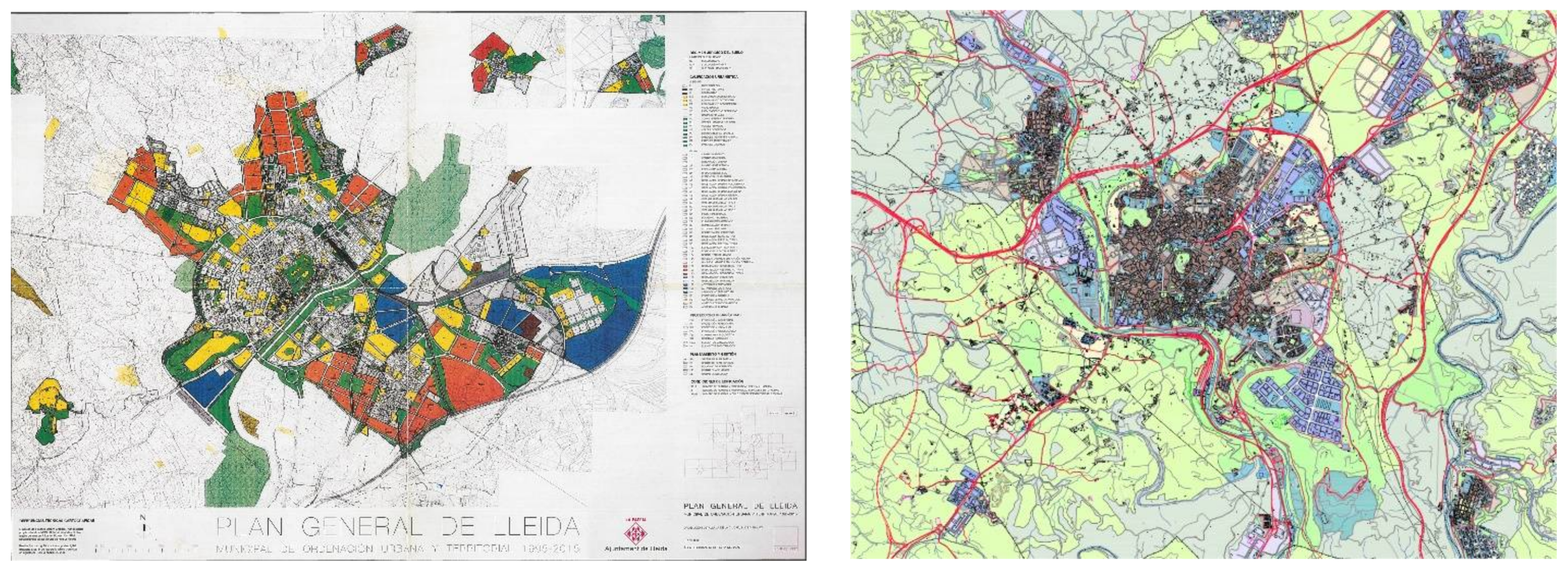
Finally, there are the Master Plans corresponding to the most recent period: the Plan de Ordenación Urbana de Lleida of 2018 (which was initially passed, but then subjected to revision by the city’s new management team following the municipal elections of 2019) and the Plan de Ordenación Urbana de Manresa, which was passed in 2017. The first things that should capture our attention in both cases are the restrictive previsions for growth and, in line with this, restrictions in the classification of land for urban development. In the case of Lleida (see Table 2), the area was 239.1 ha (with only 61.4 ha of this land being destined for residential uses). Even so, 531.3 ha were classified as non-delimited land for urban development, the majority of which was destined for industrial and logistical uses. In the case of Manresa, only 153.5 ha were classified as delimited land for urban development and 56.4 ha as non-delimited.
However, without a doubt, what should most attract our attention was the detailed organisation and regulation of the urban land that was already more or less consolidated (Figure 5). In the case of Lleida, it is relevant to add that seven Planes de Mejora Urbana (special plans for urban improvement) were proposed, including seventy-five areas/sectors for more detailed urban redevelopment, all of which have been used as instruments for the transformation of urban land. In Manresa, on the other hand, the current Master Plan contemplates fifty-three Planes de Mejora Urbana (special plans for urban improvement), seven of which only contemplate very specific transformations, in addition to a further eighty-five for more detailed urban redevelopments. Amongst these interventions, it is relevant to highlight those dedicated to dynamising the urban centres (historic centres and areas of historic urban growth), which have placed an important emphasis on fostering the regeneration of the urban fabric and reorganising mobility.
Another interesting question concerns the specific treatment that was given to land that could not be subjected to urban development in order to try to protect spaces of special natural, environmental, and landscape interest. Both cities’ Master Plans sought to combine the conservation of their areas of greatest interest—in terms of land not destined for urban development—with their use as productive spaces and for leisure purposes. Along these lines, it is important to highlight, firstly, the proposal for extensive green belts, which would permit bicycle routes and footpaths crossing the municipal areas, and, secondly, regulations to protect and maintain the productivity of the rich orchards and market gardening areas that surround both these urban nuclei. In the case of Manresa, one place of particular relevance is the agricultural park. Such action was already proposed in the Plan Director Urbanístic del Bages of 2007.
5. By Way of Conclusions
In Spain, urban planning has been one of the most important instruments used to catalyse expectations for economic growth. Since at least the middle of the 20th century, this has been based on the consumption of territory and the production of new urban land.
However, the objectives, strategies, and instruments of urban planning changed considerably over the course of the analysed period (1979–2019). Urban planning passed from meeting the initial demand of regulating activities and growth (1979–1991) to facilitating the development of land and construction via a form of urban planning that was neoliberal in nature and clearly expansive and speculative (1993–2007) and to reaching the present situation, with a form of urban planning in which the previously mentioned tendencies coexist with other new orientations.
An analysis of urban planning documentation also leads us to conclude that the key principles of the neoliberal city have been transferred to urban planning via over-dimensioning, the reclassification and requalification of land, strategic urban projects, and the mercantilisation of areas that are expected to have a high value.
In the last period, it seems that urban planning has largely gone back to focusing on the more or less consolidated parts of the cities. The main emphasis has now apparently returned to urban regeneration and rehabilitation, rather than urban growth. Even so, it is not yet clear whether the existing and established mechanisms, their development, and their management will—or will not—generate even greater urban fragmentation. The content and objectives of urban plans should perhaps give greater attention to the social dimension and understand that the ultimate objective of urban planning should be to make the lives of the people who live in our cities easier and more pleasant, rather than to promote property business.
The impact of two recent crises, the economic crisis of 2007 and the current (COVID-19) crisis, have led to questions being asked about the speculative approaches to urbanism that were used to produce new land and urban artefacts—including housing—while ignoring local needs and contexts. The result has been an urbanism that ignores the city and plans that lack a model for either the city or the territory. In this new context, and with the deployment of the UN International Urban Agenda (United Nations Sustainable Development Goal 11), first-level urban planning can perhaps recover its other classical mission—that of establishing the urban model and serving as an effective instrument that is adapted in order to meet the needs of cities.
Having an awareness of regional planning and conserving natural assets and landscape values have been relevant topics in the recent spatial planning agenda in Catalonia. In 2017, the Catalan government proposed a draft project for a Law of Territory that was to be an instrument for structuring the existing legislation on urban planning, regional planning, and landscape conservation. Its objectives included moving from extensive growth to urban recycling, ensuring the efficiency and competitiveness of the territorial system through formulas of supramunicipal governance, and adapting existing instruments to the diversity of the territories, interventions, and conjunctures encountered.
This draft bill did not proceed, but the need for new instruments and more agile, flexible, and comprehensive mechanisms remains imperative.
Funding
The current work was carried out within the framework of the research project entitled: “The evolution of urbanistic policies in Spain’s medium-sized cities and their urban areas: 1979–2019” (RTI2018-096435-B-C21), which is financed by Spain’s Ministry of Science and Innovation with the support of FEDER (EU) funding.
Conflicts of Interest
The author declares no conflict of interest.
References and Notes
- Naredo, J.M. El modelo inmobiliario español y sus consecuencias. Boletín CF+S 2010, 44, 13–27. [Google Scholar]
- López, I.; Rodríguez, E. Fin de Ciclo. Financiarización, Territorio y Sociedad de Propietarios en la Onda Larga del Capitalismo Hispano (1959–2010); Traficantes de Sueños: Madrid, Spain, 2010. [Google Scholar]
- Buriel, L.E. Subversion of land-use plans and the housing bubble in Spain. Urban Res. Pract. 2011, 4, 232–249. [Google Scholar] [CrossRef]
- García, M. The Breakdown of the Spanish Urban Growth Model: Social and territorial effects of the Global Crisis. Int. J. Urban Reg. Res. 2010, 34, 967–980. [Google Scholar] [CrossRef] [Green Version]
- Górgolas, P. Burbujas inmobiliarias y planeamiento urbano en España: Una amistad peligrosa. Cuad. Investig. Urban. Ci[ur] 2017, 111, 3–65. [Google Scholar] [CrossRef] [Green Version]
- Harvey, D. The Urbanization of Capital; John Hopkins University Press: Baltimore, MD, USA, 1985. [Google Scholar]
- Vives, S.; Rullán, O. La apropiación de las rentas del suelo en la ciudad neoliberal Española. Boletín Asoc. Española Geogr. 2014, 65, 387–408. [Google Scholar] [CrossRef]
- Lois, R.; Piñeira, M.J.; Vives, S. El proceso urbanizador en España (1990–2014): Una interpretación desde la geografía y la teoría de los circuitos de capital. Scr. Nova—Rev. Electrónica Geogr. Cienc. Soc. 2016. Available online: https://revistes.ub.edu/index.php/ScriptaNova/article/view/539 (accessed on 2 July 2020).
- Bellet, C. Municipal planning policies in Spain: 40 years of democratic city councils (1979–2019). Boletín Asoc. Geógrafos Españoles 2020, 85, 1–38. [Google Scholar]
- The Spanish state reserves some competences that, without being urbanistic, affect the urban environment in a very clear way. These include those outlined in the Spanish Constitution of 1976 relating to: The equality of rights and obligations (art. 149.1.1ª); civil legislation (art. 149.1.8ª); the bases for, and coordination of, the general planning of economic activity (art. 149.1.13ª); the bases of the juridical regimes of the public administrations (art. 149.1.18ª CE); basic legislation governing the protection of the natural environment (art. 149.1.23ª); and anything else that affects more than one Autonomous Community when it comes to applying sectorial policies.
- Hernández Partal, S. Los instrumentos de planeamiento urbanístico en España. Estudio Comparado (I). Ciudad Territ. Estud. Territ. CyTET 2020, LII-205, 613–652. [Google Scholar]
- Hernández Partal, S. Los instrumentos de planeamiento urbanístico en España. Estudio Comparado (II). Ciudad Territ. Estud. Territ. CyTET 2020, LII-206, 945–970. [Google Scholar]
- Ministerio de Obras Públicas y Urbanismo-MOPU. 10 Años de Planeamiento Urbanístico en España; Instituto del Territorio y Urbanismo: Madrid, Spain, 1990. [Google Scholar]
- Ferrer, A. El planejament urbanístic. In 10 Anys d’Ajuntaments Democràtics; Nel.lo, O., Ed.; Federació de Municipis de Catalunya: Barcelona, Spain, 1989; pp. 133–179. [Google Scholar]
- Olazabal, E.; Bellet, C. De la ciudad compacta a la ciudad extensa. Procesos de urbanización recientes en áreas urbanas españolas articuladas por ciudades medias. An. Geogr. Univ. Complut. Madr. 2019, 39, 149–175. [Google Scholar] [CrossRef] [Green Version]
- Cebrián, F. Ciudades con límites y ciudades sin límites. Manifestaciones de la ciudad difusa en Castilla-La Mancha. Boletín Asoc. Española Geogr. 2007, 43, 221–240. [Google Scholar]
- Naredo, J.M. La Burbuja Económico-Financiera en la Coyuntura Económica Reciente (1985–1995); Siglo XXI: Madrid, Spain, 1996. [Google Scholar]
- Roca Cladera, J.; Burns, M.C. The Liberalization of the Land Market in Spain: The 1998 Reform of Urban Planning Legislation. Eur. Plan. Stud. 2000, 8, 547–564. [Google Scholar] [CrossRef]
- Calderón, B.; García, J.L. Legislación urbanística y planeamiento urbano en España, 1998–2015. Del despilfarro a la sostenibilidad. Scr. Nova—Rev. Electrónica Geogr. Ciencias Soc. 2017. Available online: https://revistes.ub.edu/index.php/ScriptaNova/article/view/19429. (accessed on 1 June 2020). [CrossRef] [Green Version]
- Lobato Becerra, J.A. Notas sobre la obsolescencia de los planes generales: Planificación estratégica y modelo urbano. Ciudad Territ. Estud. Territ. CyTET 2020, LII, 197–210. [Google Scholar]
- Rullán, O. La planificación urbana y territorial en tiempos de crisis. In Libro Jubilar en Homenaje al Profesor Antonio Gil Oncina; Olcina, J., Rico, A., Eds.; Publicaciones de la Universidad de Alicante: Alicante, Spain, 2016; pp. 1267–1286. [Google Scholar]
- Ferrer, A.; Solà-Morales, M. El urbanismo municipal en España. Pap. Regió Metrop. Barc. 2005, 43, 4–108. [Google Scholar]
- Law 2/2002 Cites amongst Its Objectives: Working Towards Sustainable Urbanistic Development and the, Always Promised, Simplification of Urbanistic Procedures. The Principles of this Law Are Presented in the Text Included in DL 1/2010, of 3 August (Law 16569/2010), Which Is Still in Force in Catalonia. Available online: https://www.boe.es/buscar/doc.php?id=BOE-A-2010-13883 (accessed on 2 September 2020).
- Nel.lo, O. El planeamiento territorial en Cataluña. Cuad. Geográficos 2010, 47, 131–167. [Google Scholar]
- Sotoca, A. Urban growth management in Catalonia, 2005–2010. Urban Res. Pract. 2016, 9, 91–102. [Google Scholar] [CrossRef]
- Bellet, C. Proyectos y grandes operaciones urbanas. In Naturaleza, Territorio y Ciudad en un Mundo Global; AA.VV. Universidad 574 Autónoma de Madrid y AGE; UAM: Madrid, Spain, 2017; pp. 1249–1265. [Google Scholar]
- Burriel, E. La ‘década prodigiosa’ del urbanismo español (1997-2006). In Diez Años de Cambios en el Mundo, en la Geografía y en las Ciencias Sociales, 1999–2008. Actas del X Coloquio Internacional de Geocrítica; AAVV; Universitat de Barcelona: Barcelona, Spain, 2008. [Google Scholar]
- Romero, J. Construcción residencial y gobierno del territorio en España. De la burbuja especulativa a la recesión. Causas y consecuencias. Cuad. Geogr. 2010, 47, 17–46. [Google Scholar]
- Gaja Díaz, F. El “tsunami urbanizador” en el litoral mediterráneo. El ciclo de hiperproducción inmobiliaria 1996–2006. Scr. Nova—Rev. Electrónica Geogr. Cienc. Soc. 2008. Available online: http://www.ub.edu/geocrit/sn/sn-270/sn-270-66.htm (accessed on 20 February 2019).
- del Valle, R.M.G. La Telaraña Financiera. Una Geografía de la Financiarización y su Crisis; RiL, Ed.; Instituto de Geografía, Pontificia Universidad Católica de Chile: Santiago de Chile, Chile, 2018. [Google Scholar]
- Calderón, B.; García, J.L. La estructura de las ciudades españolas: Un complejo entramado de relaciones entre permanencias y cambios, formas y usos. Boletín Asoc. Geogr. Española 2018, 77, 283–314. [Google Scholar] [CrossRef]
- García-Herrera, L.M. Mercantilización del espacio urbano bajo la lógica neoliberal: Gentrificación y redefinición de los espacios públicos en España. In Naturaleza, Territorio y Ciudad en un Mundo Global; AA.VV.; Universidad Autónoma de Madrid y AGE: Madrid, Spain, 2018; pp. 858–877. [Google Scholar]
- Romero, J.; Brandis, D.; Melo, C. El giro neoliberal de las políticas para la Ciudad en España. Balance a partir de los casos de Madrid y Valencia. Boletín Asoc. Geogr. Española 2015, 69, 369–386. [Google Scholar]
- Instituto Nacional de Estadística–INE, Padrón Municipal de Habitantes. 2019. Available online: https://www.ine.es/dyngs/INEbase/es/categoria.htm?c=Estadistica_P&cid=1254734710990 (accessed on 20 February 2019).
- The urban areas that are considered here are those delimited by the Atlas Estadístico de las Áreas Urbanas del Ministerio de Transportes, Movilidad y Agenda Urbana (MITMA, 2018). This delimitation tends to include fewer municipalities than that produced for the Urban Audit (Eurostat) and based on Functional Urban Areas (FUA).
- Institut Cartogràfic i Geològic de Catalunya (IGGC). Available online: https://www.icgc.cat/ (accessed on 20 May 2020).
- The urban history of Manresa has seen five different Master Plans: The Plan de Reforma y Ensanche of 1939, the Plan General of 1964, the Plan General of 1981, the Plan General of 1997 and the current Plan, which dates from 2017.
- The municipality of Lleida has also had 5 Master Plans: The Plan de Ensanche of 1865, the Plan de Ensanche of 1925, the Plan General de Ordenación Urbana of 1957, the Plan General Municipal of 1979 and the Plan General de Ordenación Urbana of 1999. Work is currently underway on a new Plan General (2015–2020), which was initially passed in 2018.
- Census of Population, Building and Housing (1981, 1991, 2001 and 2011) and Municipal Population Register of 2019, of the Instituto Nacional de Estadística–INE. Available online: https://www.ine.es/ (accessed on 15 April 2020).
- Information about Non-Current Planning was Consulted in the Archives of Lleida City Council and the Planning Archive of the Departament de Territori i Sostenibilitat of the Generalitat de Catalunya in Barcelona. Current Planning, as of February 2020, was Consulted via the Platform of the Registre de Planejament Urbanístic de Catalunya (RPUC). Available online: https://dtes.gencat.cat/rpucportal/inici/es/index.html (accessed on 15 February 2020).
- Llop, C. Atlas Urbanístic de Lleida 1707–1995; Ajuntament de Lleida: Lleida, Spain, 1995; p. 107. [Google Scholar]
- Ajuntament de Manresa Public Documents Open Access. Available online: https://www.manresa.cat/web/menu/3758-planejament-historic (accessed on 15 February 2020).
- Llop, J.M.; García Catalá, R. El Plan General Municipal de Ordenación Urbana y Territorial de Lleida, 1995–2015. Urban 2007, 12, 86. [Google Scholar]
- Ferrer, A.; Sabaté, J. Introducció: l’Urbanisme municipal vist pels professionals. Pap. Rev. Regió Metrop. Barc. 1999, 32, 9–18. [Google Scholar]
- Ajuntament de Manresa, Memoria del Plan General de Manresa, 1997, point 2. Non edited public planning documentation. Consulted at the central archive of the Departament de Territori i Sostenibilitat, Generalitat de Catalunya (Barcelona).
- Bellet, C.; Alonso, M.P.; Gutiérrez, A. The High-Speed-Train in the Spanish cities: Urban integration and strategies for socioeconomic dynamisation. In Territorial Implications of High-Speed-Rail. A Spanish Perspective; Ureña, J.M., Ed.; Ashgate Pub.: Farnham, UK, 2012; pp. 163–196. [Google Scholar]
- Lleida 1999 Master Plan. Available online: https://urbanisme.paeria.cat/planejament-i-habitatge/Revisio_del_Pla_general_Ordenacio_Urbana_de_Lleida_1995-2015 (accessed on 22 October 2020).
- Manresa 1997 Master Plan from Mapa Urbanístic de Catalunya Departament de Territori i Sostenibilitat of the Generalitat de Catalunya. Public Documentation. Available online: http://dtes.gencat.cat/muc-visor/AppJava/home.do (accessed on 27 December 2016).
- The Manresa 2017 Master Plan. Public Document. Available online: https://www.manresa.cat/web/article/635-pla-general-de-manresa (accessed on 10 January 2019).
- The Lleida 2015–2035 Master Plan Proposal. Public Document. Available online: https://poumlleida.paeria.cat/doc_aprov_inicial.html (accessed on 12 February 2019).
Figure 1.
Property dynamics in Spain and Catalonia and urban planning periods. Housing units built in Spain (left axis) and Catalonia (right axis) (data from https://www.mitma.gob.es/vivienda (accessed on 23 March 2019) and http://habitatge.gencat.cat/ca/dades/estadistiques_publicacions/ (accessed on 20 March 2019).
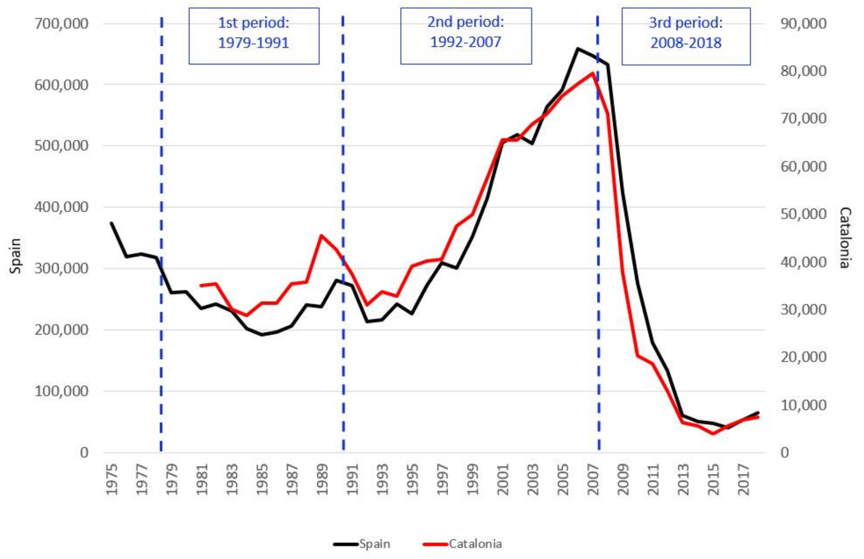
Figure 2.
Urban areas and municipalities of Lleida and Manresa. Own elaboration based on Institut Cartogràfic i Geològic de Catalunya [36].
Figure 2.
Urban areas and municipalities of Lleida and Manresa. Own elaboration based on Institut Cartogràfic i Geològic de Catalunya [36].
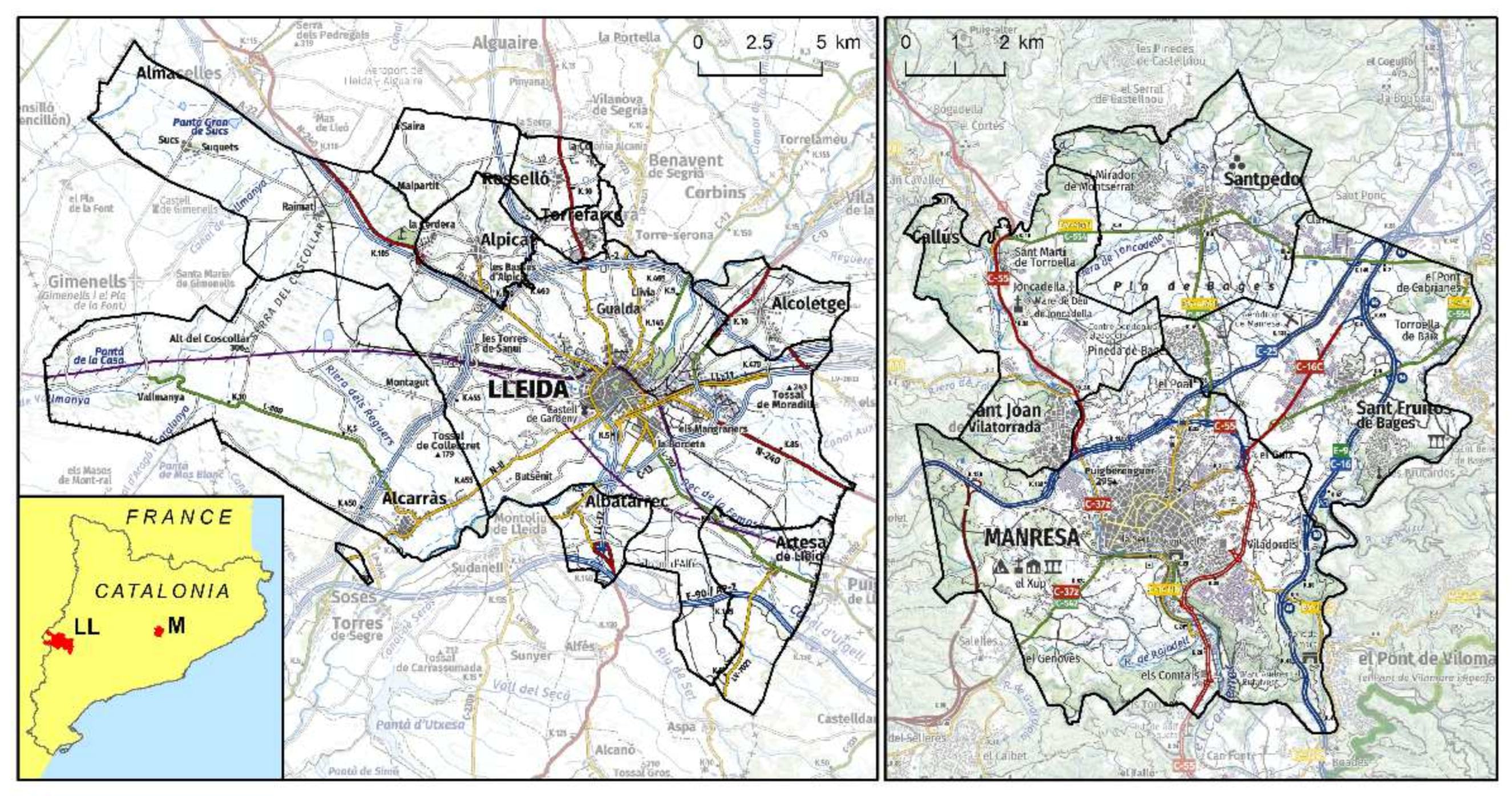
Figure 3.
Plan General Municipal de Lleida of 1979 (left), reprinted with permission from ref. [41] and Plan General Municipal de Manresa of 1981 (right), reprinted with permission from ref. [42].
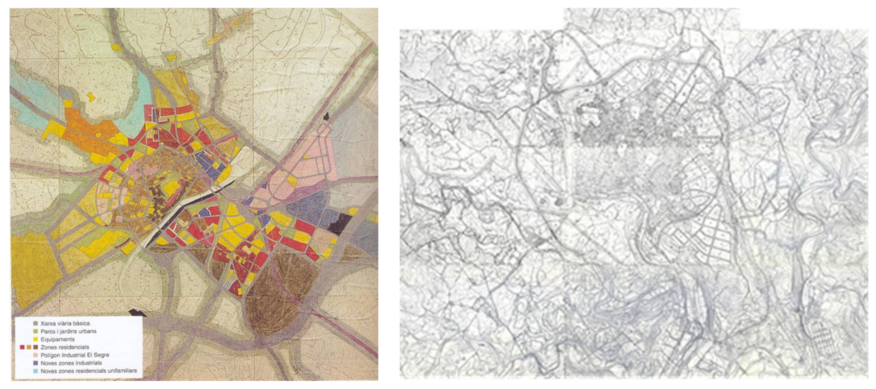
Figure 5.
The Plan de Ordenación Urbana Municipal de Lleida of 2018 (left) reprinted with permission from ref. [49] and the Plan de Ordenación Urbana de Manresa of 2017 (right) reprinted with permission from ref. [50].
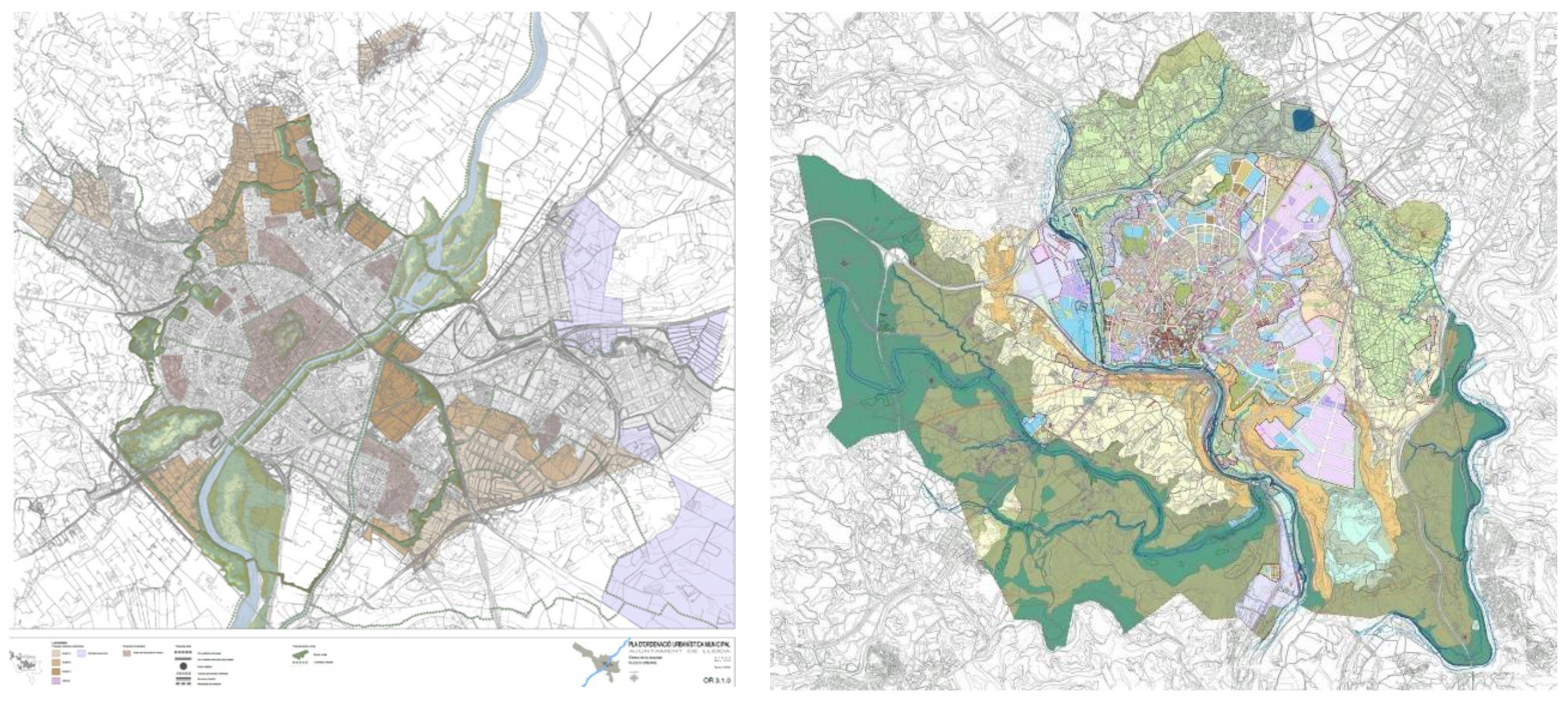
Table 2.
Potential for growth, housing, and land classification in the different Master Plans for Lleida and Manresa [40].
Table 2.
Potential for growth, housing, and land classification in the different Master Plans for Lleida and Manresa [40].
| Lleida | 1979 | 1999 | 2018—Initially Approved |
| Maximum potential for growth in population | 150,000 | 144,623 (200,000 PTGC) | 136,000–170,000 |
| Potential growth for housing units (a) | ------- | 25,781 units | 29,298 units (b) |
| Land classified as urban | 1234 ha | 1430.47 ha | 1823.8 ha |
| Delimited land for urban development | 132.68 ha | 503.8 ha(385 ha residential land.) | 239.1 ha (61.4 Ha residential land) |
| Non-delimited land for urban development | 1340.64 ha | 307.58 ha | 531.3 ha |
| Total land available for urban development | 1473.32 ha | 811.38 ha | 770.4 ha |
| Manresa | 1981 | 1997 | 2017 |
| Maximum potential for growth in population | 135,000–150,000 | 90,000 | 92,042–100,000 |
| Potential growth for housing units (a) | ------- | 13,246 units | 10,505 units |
| Land classified as urban | 631.52 ha | 642.25 ha | 778.99 ha |
| Delimited land for urban development | 77.79 ha | 164.0 ha | 153.507 ha |
| Non-delimited land for urban development | 176.32 ha | 223.7 ha | 56.36 ha |
| Total land available for urban development | 254.11 ha | 387.76 ha | 209.867 ha |
a—Potential housing on unconsolidated urban land and delimited/sectorialised and non-delimited/non-sectorialised urban land. b—10,295 housing units on unconsolidated urban land and 15,909 on undelimited land earmarked for urban development.
Publisher’s Note: MDPI stays neutral with regard to jurisdictional claims in published maps and institutional affiliations. |
© 2021 by the author. Licensee MDPI, Basel, Switzerland. This article is an open access article distributed under the terms and conditions of the Creative Commons Attribution (CC BY) license (https://creativecommons.org/licenses/by/4.0/).
Share and Cite
MDPI and ACS Style
Bellet Sanfeliu, C. The Evolution of Urban Planning in Medium-Sized Catalan Cities (1979–2019). Urban Sci. 2021, 5, 36. https://0-doi-org.brum.beds.ac.uk/10.3390/urbansci5020036
AMA Style
Bellet Sanfeliu C. The Evolution of Urban Planning in Medium-Sized Catalan Cities (1979–2019). Urban Science. 2021; 5(2):36. https://0-doi-org.brum.beds.ac.uk/10.3390/urbansci5020036
Chicago/Turabian StyleBellet Sanfeliu, Carme. 2021. "The Evolution of Urban Planning in Medium-Sized Catalan Cities (1979–2019)" Urban Science 5, no. 2: 36. https://0-doi-org.brum.beds.ac.uk/10.3390/urbansci5020036