1. Introduction
On the one hand, human activities have long caused profound changes in the integrity and diversity of urban landscapes. On the other hand, nature, the landscape and the environment are generating ever-increasing expectations in the name of sustainability and the living environment of our modern societies. This research first considers the diversity of environments that compose an urban landscape and the multiplicity of interactions with human beings. From these relationships, the objective is secondly to develop a methodological framework based on a dual structural analysis and field observation, taking into consideration the diversity of perceptions and actions that connect humans to their surrounding urban landscape. This is motivated by the fact that natural landscapes in the city might have a significant impact on humans’ ‘natural’ movements. This leads us to combine a structural analysis as derived from space syntax principles with an analysis of the diversity of users’ movements according to the characteristics of these natural landscapes and their recorded frequentation in space and time. The aim is to derive a better comprehension of the current interrelations between the fabric of the city, natural landscapes and human movements.
The presence of natural elements contributes to the quality of life and brings many benefits to social, economic, and environmental functions [
1]. Urban parks are very attractive for different reasons: either to get fresh air, to take a walk, or to exercise a recreational activity [
2]. Their attractiveness depends on several factors such as their size (i.e., the larger the area of the park, the more attractive the park will be for users coming from far away), degree of openness/vegetation density, maintenance, and accessibility, which will also influence the type of landscape users [
3]. Natural landscapes are thus often associated with planning projects to ensure a better urban sustainability. In a more general way, new relationships between the city and natural landscapes participate in the “urban atmosphere”, which can be defined as a dual combination of physical and social patterns which “try to associate objective, measurable elements, for example physical (morphology, density, mineralization, urban micro-climate…), more subjective elements that vary according to the differential uses and perceptions of the sensitive [...], and characterizations pertaining to an urban aesthetics of multi-sensoriality, which do not reduce urbanism to the aspects of the visual form”.
“The landscape is both inherently visual and also much more than simply visual” [
4]. The urban landscape is a complex and dynamic system. Considered as a morphological, physiognomic, social, and cultural differentiated whole, it presents an environment with specific characteristics where various human/environment interactions involving space are articulated [
5]. The landscape is considered as “the research practices and spatial solutions to questions, problems and social conflicts involving the human relationship to land space”. The psychological, the cognitive, and the experiential are the main dimensions that characterize such a landscape [
6]. The existence of natural neighborhood landscapes in the city highlights an adaptable physical setting for city dwellers that reinforces social relations and improves their comfort and well-being [
7]. Forests near urban areas represent a natural resource for the city. They are considered a vital element of the urban landscape, urban infrastructure, and quality of life in cities [
8]. They are defined as open spaces of great social and environmental importance to the city.
An urban forest forms a matrix, potentially connecting different urban spaces in the city and particularly the built environment. Indeed, urban forests perform a variety of functions as components of the larger urban ecosystem and contribute to the spatial and dynamic structure of urban communities. Environmentally, urban forests can provide a number of benefits including climate improvement and air and noise pollution reduction. Socially, they provide space for nature-based recreation and promote physical activity and urban mixing [
9]. They create a sense of belonging and shared community and help maintain a cultural heritage [
10]. The relationship between residents and the forest depends on existing regulations, land use planning [
11], and management and maintenance practices [
12]. This relationship is reinforced by the appropriation of space by users according to their own characteristics [
13]. Many cities worldwide share convergent practices to create walkable and natural environments. Such elements are exemplified by ‘line parks’ in New York, ‘boulevards’ in Paris, picturesque Straatjes streets in Amsterdam’s canal belt, and the Luchtsingel pedestrian bridge in Rotterdam [
14].
Two closely related previous studies on Chicago low-income neighborhoods showed a positive relationship between the presence of green public facilities and social connectedness [
15,
16]. It appeared that green neighborhoods favor the use of common spaces and strengthen social ties in these areas [
16]. In England, it has been shown that the presence of urban natural areas make city dwellers reluctant to travel long distances for daily outdoor activities [
17]. In Germany, migrants from the Balkans and Russia prefer to take a leisurely walk in an urban forest, while migrants from Turkey prefer to interact with others even when walking in urban green areas [
18]. Most users come to urban forest parks in Japan with family or friends, such as families with children, couples, and young groups [
19]. Overall, different social conditions are likely to interact in urban forest parks as far as different uses and meeting recreational opportunities are provided [
19].
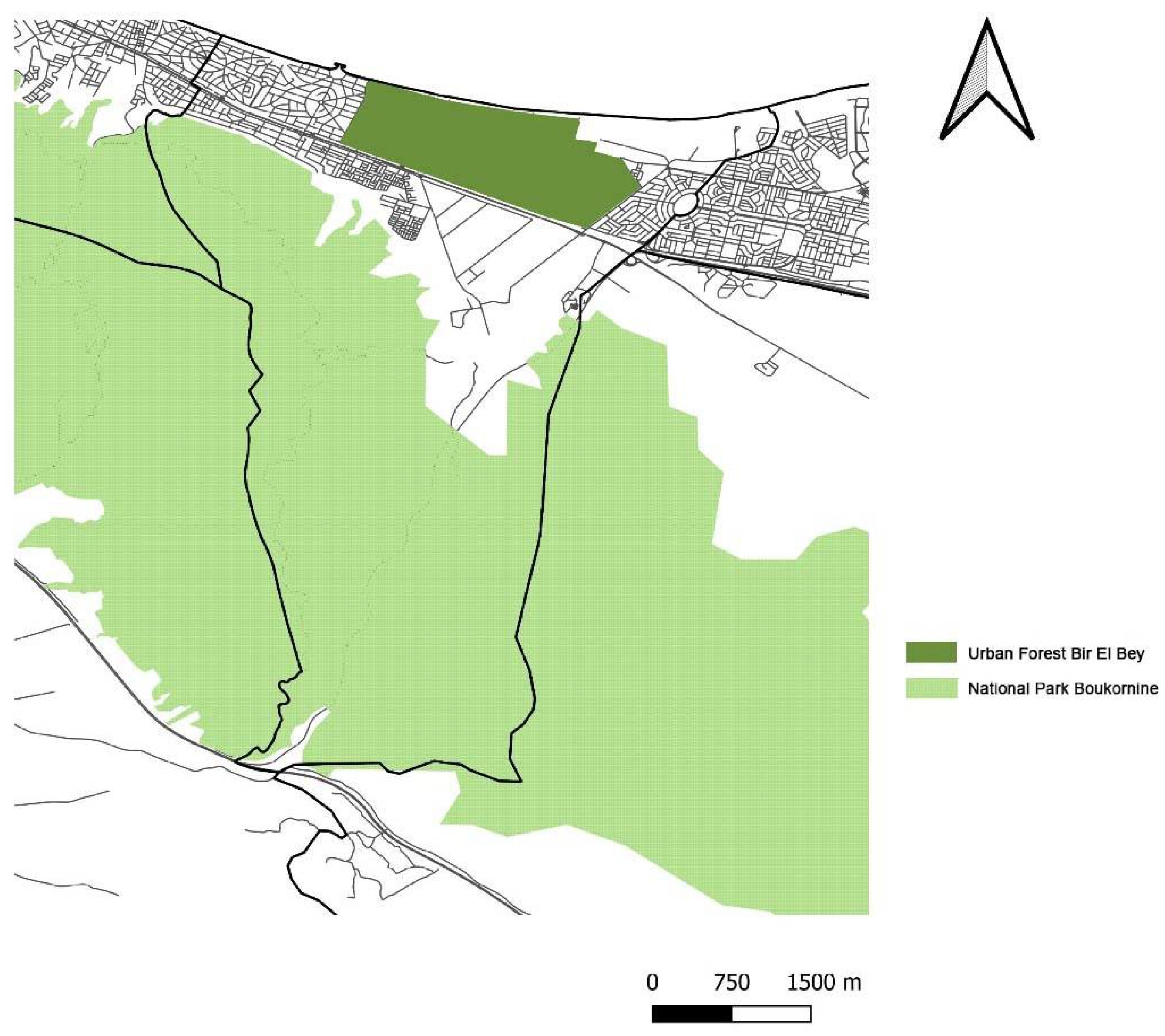
In Tunisia, urban forests are part of the natural protected areas according to the legislation in force, which is motivated to conserve biodiversity for ecological purposes without taking into consideration the riparian population. From 1960 onwards, forestry policies began to be harmonized with the general policy of economic and social development. The relationships of citizens with the forest was consolidated mainly through the creation of urban parks in forests and the densification of the road network [
20]. Urban parks are managed by municipalities and play a social role of great importance in welcoming the city’s residents. Several forests have not been developed. Their accessibility remains very limited because it is managed by the forestry administration. This research aims to support the knowledge and practice of urban landscape design and contribute to the broader field of pedestrian and vehicular accessibility in cities by providing new empirical knowledge about the concrete level in which urban design and landscape practices operate. We question this type of forest and more specifically the urban forest of Bir El Bey, which is the unique urban forest in the metropolis of Tunis devoid of any special leisure facilities for the inhabitants of the city despite its large area (3.5 km
2). This forest offers an attractive landscape in contrast with the urban space that is surrounding it and creating an attraction potential for the city. It presents the only means of access to the sea by the inhabitants. It is near the railway line that connects the southern suburbs to the northern suburbs. Its surface, which dominates the city, and its location on the city scale and on the metropolitan scale reinforces its attractiveness and allows the inhabitants to appropriate the space and to choose their preferred itineraries.
The focus of this research is oriented to complementary dimensions: first the degree of integration of human movements close to natural landscapes in the city, secondly movement and accessibility patterns as extracted from the urban network layout. This leads us to apply the theory of natural movement [
21]. The objective is to examine the effect of urban forests on the use of neighborhood spaces based on the patterns extracted from a space syntax evaluation of natural movement patterns. This aim is to provide an evaluation approach that can not only characterize some human movement patterns in the city, but also possible planning perspectives for a better design of the city layout. This approach offers the possibility to estimate the theoretical accessibility or “natural motion” by measuring integration patterns throughout axial analysis. Practically, the axial analysis quantitatively evaluates the effect of the proximity urban forest on nearby users’ practices. Indeed, the expected findings should highlight the importance of such natural landscapes in the city. The rest of the paper is organized as follows.
Section 2 presents the case study while
Section 3 introduces the principles of our methodological approach.
Section 4 reports on the experiments while
Section 5 discusses the findings. Finally,
Section 6 summarizes our research and outlines a few perspectives for further work.
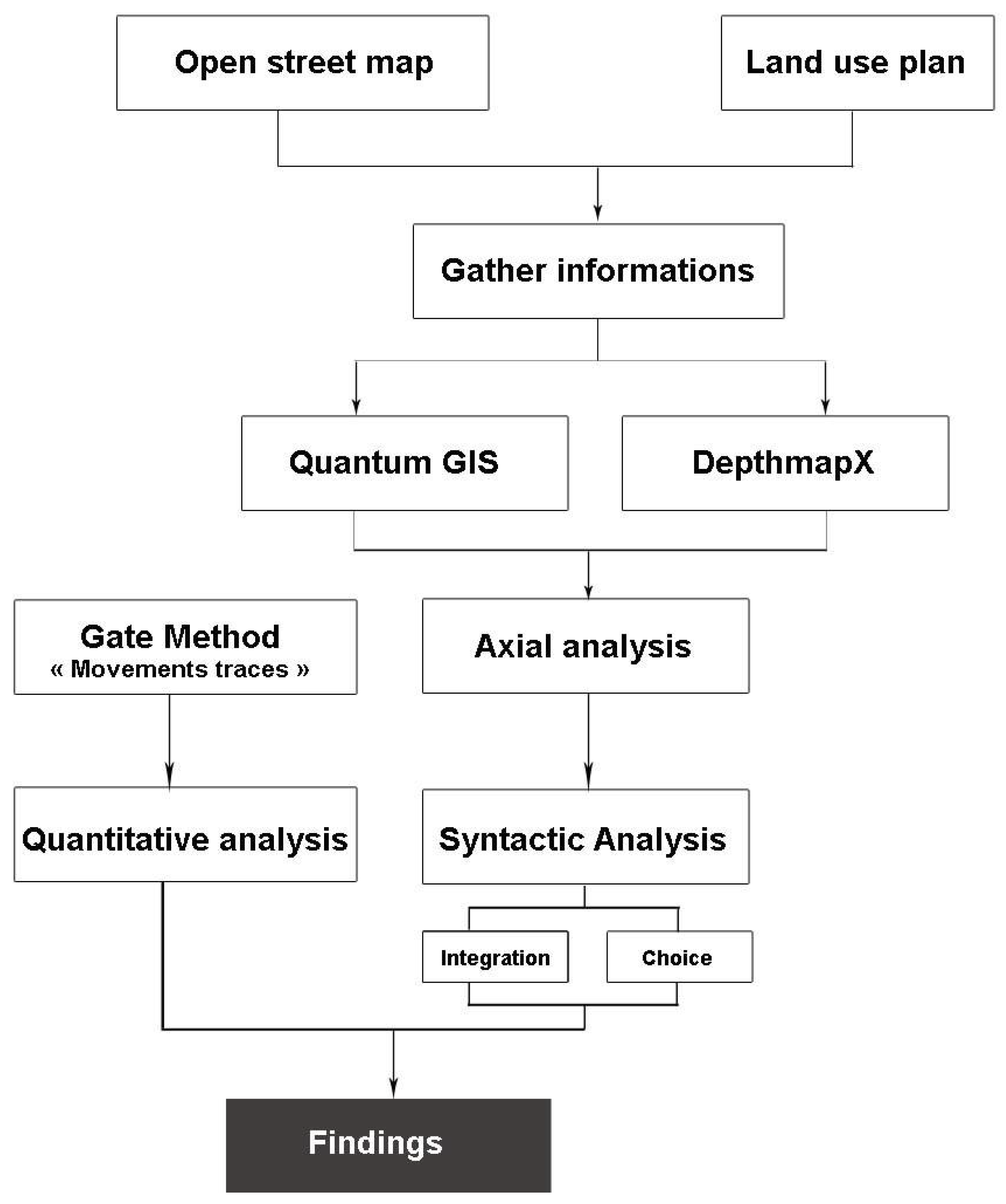
3. Methodological Approach
Much research has been conducted in different contexts and has shown the correlation between urban form and human behavior [
22]. Several studies have been performed to assess the accessibility of urban green space. Some of them have evaluated the amount of green space in a buffer zone around a neighborhood [
23,
24]. Other studies have measured the Euclidean distance along a road network as the shortest distance to the nearest green space [
25,
26]. These methods have been oriented towards quantitative evaluations of the accessibility to the nearest green spaces and parks but have ignored additional structural and qualitative factors such as the level of attraction and other recreational options offered to the residents. Previous approaches lacked completeness and feasibility in assessing the distribution of accessibility locally and across the entire city. In a related work, Reyes evaluated walking accessibility to city parks for children in Montreal through a statistical analysis of trips length based on survey data Surveys [
27]. However, no close connection to the urban forms and movement patterns have been so far studied to understand the complete urban space properties and close relations between the urban natural and city layouts.
The theories of Lynch [
28] and Jacob [
29] address the question of spatial cohesion as a condition for the proper functioning of the urban landscape. The proposition resulting from this seminal research contribution is that humans often draw on information on how paths in a city are interrelated. The main notion behind this principle is the one of spatial configuration. The role of spatial configuration on pathways within public gardens considers green spaces as attractive places for local people which are integrated with the wider urban landscape [
6]. A green space in an urban area encompasses a range of environments and experiences for the community and a complementary setting for its built elements [
30]. Eventually, the works of [
31] have studied landscape preferences, through a landscape qualification of the street network layout. However, multiple works based on space syntax analyses have found a differential association of the street network with the distribution of attractive land uses in various urban contexts [
32,
33].
Space Syntax studies have reported that neighborhoods and urban areas exhibit different pedestrian interactions and travel patterns with the street network and some specific distribution of attractive land uses [
34]. This offers a way of measuring the spatial configuration that represents an environment as a network of nodes and interconnecting links, which can be analyzed as a graph [
35,
36]. Space syntax brings a contribution to the advancement of research in the field of landscape design, including street grid configurations. Among the various techniques for space syntax analysis, axial analysis seems most suitable for applications in urban environments [
37]. The resultant map is analyzed as a graph; centrality and periphery measures have proved to be particularly effective proxies for aggregating pedestrian movement when compared with direct observational counts, including the “gate method”, which is a workhorse of spatial observing techniques that allows researchers to collect observations of moving people or vehicles [
38,
39].
3.1. Measuring Spatial Configurations through Space Syntax Analysis
By using space syntax techniques along with a movement observation survey, our research explores two issues: first, clustering patterns of land use categories in terms of spatial accessibility within the urban development; second, the effect of ‘attractor’ natural landscape and configuration properties of the forest on the distribution of movement densities. Space syntax uses several measures to quantify configurational attributes of spaces, such as Depth, Connectivity, Control, and Integration, and has been widely used in measuring configurational attributes of the urban environment [
40]. We applied an axial map analysis using the measure of Integration that evaluates the to-movement potential of a given axial line, while the measure of Choice evaluates the through-movement potential of a given axial line in the graph [
41]. These two structural measures represent two complementary forms of movement in an urban network by evaluating either the potential shortest movements to all other locations in the graph (i.e., Integration) or evaluating the capacity of a given location to lie in a path of all the shortest paths between all locations of the graph (i.e., Choice). Although route choice is affected by aesthetics, safety, travel time, and other factors that can differ from the usual shortest routes [
42,
43], the common guiding assumption often underpinning pedestrian volume modeling is that people try to minimize trip length [
44]. Moreover, two syntactical properties are likely to reflect the type of land use that would fit best in this space [
45]. Finally, the correlation between Choice and Integration measurements should be examined since this represents the likeliness of an area having a central quality, which could generate contact [
46]. Space syntax incorporates the notion of scale in its analysis as urban areas can be analyzed using two predominant scales: a global and a local one that reflect different socio-spatial experiences.
The relation between the local and global structural properties that emerges is addressed through the measures of synergy and intelligibility. Hillier introduced the notion of Intelligibility, which is closely connected to Lynch’s concept of legibility or imageability [
47]. ‘The property of ‘intelligibility’ in a deformed grid means the degree to which what we can see from the spaces that make up the system, that is, how many other spaces they are connected to, is a good guide to what we cannot see, that is, the integration of each space into the system as a whole. An intelligible system is one in which well-connected spaces also tend to be well-integrated spaces. An unintelligible system is one where well-connected spaces are not well integrated, so that what we can see of their connections misleads us about the status of that space in the system as a whole [
47]. A second measure introduced by Hillier, called ‘synergy’, is relatively similar to the one of Intelligibility. It is the measure for an area, of the correlation between Global Integration and Local Integration. This denotes how much a local street system is a reliable predictor of the global configuration. For example, Synergy appears to be strong in named neighborhoods and weak over random areas of London. Considering Integration values for a group of spaces has been also applied to neighborhoods in a Dutch city using maps of the average integration (for a space the average integration is given by the average of all the Integration values of its connected neighborhood spaces) and suggested that for Dutch settlements the whom city layout appeared to be relatively similar to the one of the neighborhoods [
48].
Space syntax models of pedestrian and vehicle flows can contribute to a better understanding of how street networks behave in relation with urban forest areas, and then reveal observed reciprocities between street networks, travel flows, and preferences in the city. The global scale can be said to refer to the background network, which is characterized by proportionally fewer and longer streets that intersect each other at obtuse angles. This is in contrast to the local network, which is embedded within the foreground and has a larger number of shorter streets that tend to intersect at near right angles [
49].
3.2. Experimental Procedure: The Gate Method
The ‘Gate method’ allows to measure and observe movement data in the city and more specifically pedestrian or vehicle movements [
38,
39,
50,
51]. Therefore, the ‘Gate method’, oriented to the extraction of ‘movement traces’, evaluates the axes traveled by the movements of the pedestrians [
52]. This method allowed us to follow and trace all the users’ itineraries with the number of people crossing the considered space as structurally observed by Space Syntax approaches [
53]. The modelling of pedestrian flows has been previously apprehended by the conceptual and methodological framework of the space syntax [
21]. In particular, it has been shown that spatial configuration is a relevant factor driving wayfinding processes [
54].
3.3. Data Collection and Modeling
The analysis of the impact of the urban forest on spatial practices was based on the concept of movement, visibility and accessibility, which are considered here as the main factors in the appropriation of spaces. The application of spatial syntax analysis combined with the results of the ‘Gate method’ analysis modeled by ‘movement traces’ leads to the development of a hybrid model of analysis and investigation. The Gate method is a technique rented from sociology and social psychology, whose scientific observation differs from simple impression by the fact that it is collected in a systematic way [
55]. The evidence reveals that during wayfinding, participants choose the most connected streets, measurable with space syntax variables of relative street connectivity [
56]. Four space syntax variables are used: Integration and Choice at global and local scales.
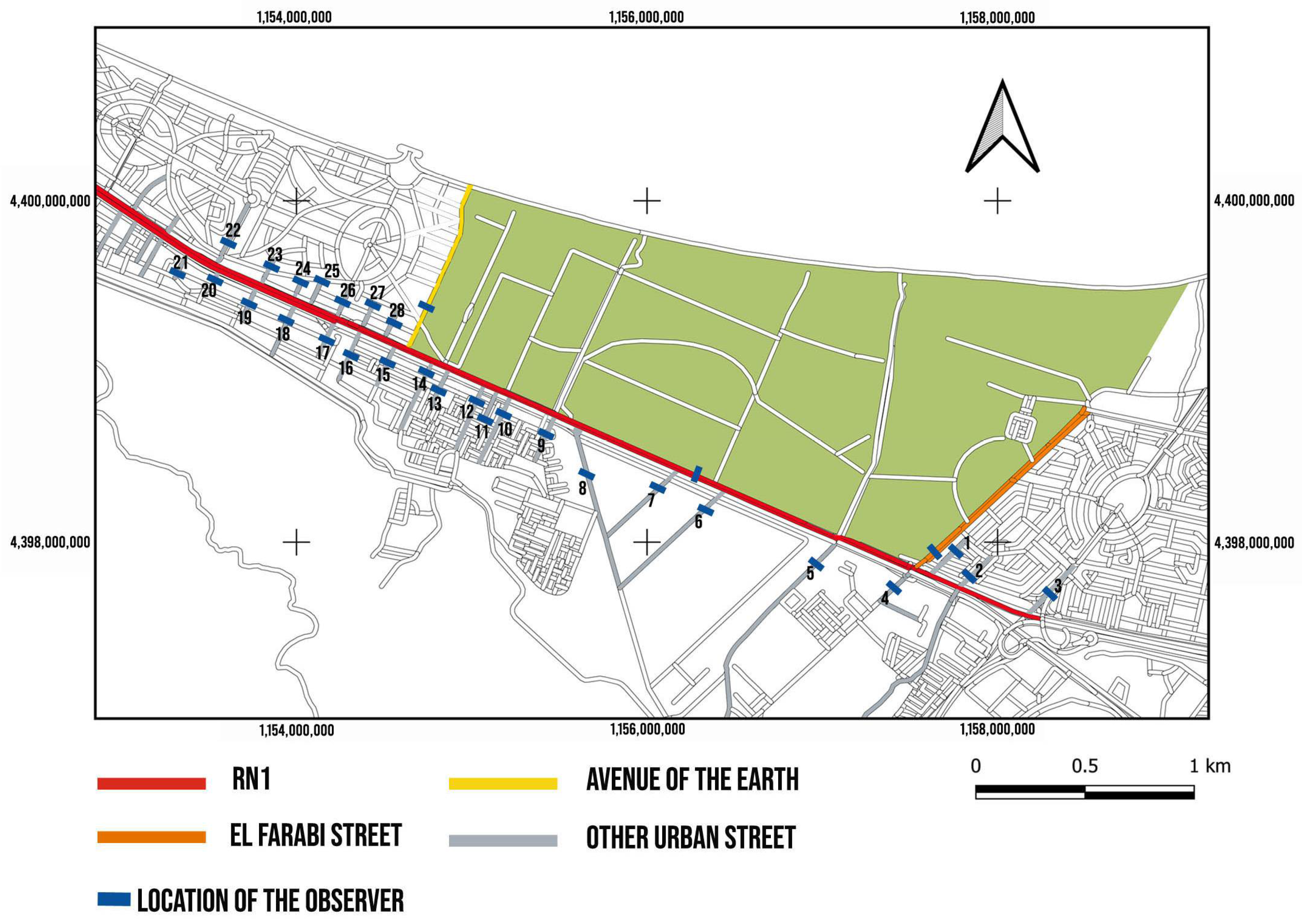
In order to explore the overall impact of the urban forest in the city, the analysis was conducted between the different peripheral axes of the forest in order to compare the axes bordering the forest to the other axes connected to the main RN1 street of the city. The choice was made in view of (1) the linear centrality that the city of Bir El Bey presents and where the RN1 axis presents the most connected axis at the urban scale, and (2) the location of the forest at the interface of El Farabi and ‘Avenue de la Terre’ and their connection to RN1. This allows us to objectively evaluate all the axes connected to the main street in order to compare El Farabi and Avenue de la Terre to the other axes of the city and, overall, derive some movement ‘preferences’.
The pedestrian and motorized traffic observation campaign was performed on a sample of 26 roads, as shown in
Figure 4, corresponding to the 6% of all Bir El Bey roads (in Bir El Bey, there are 470 roads). They were chosen to be representative of Bir El Bey roads and are those that are directly connected to the main axis of the city RN1, that is, the streets that are within a degree of connectivity to the main street RN1 (
Figure 4).
The last step was to get an idea of the relationship between the syntactic data and the movement observations on site. Descriptive statistics have been applied to validate the overall results. A pre-processing step has normalized all quantitative attributes. The data were modeled by (i) a Principal Component analysis (PCA), and (ii) an Ascending Hierarchical Classification (AHC). PCA is a fundamental statistical technique that has established its significance in signal processing through numerous successful applications including identifying a smaller set of artificial variables that summarize the original data with minimal loss of information. By analyzing the composition of these components, one can filter out the most important attributes for further analysis [
57]. As for the AHC, it presents a classification method whose principle is to group individuals according to their similarities. At the end of the second phase, the resulting structure is a sequence of nested partitions which can be visualized using a graphic called dendrogram [
58]. In order to clarify the overall results of the parsing and field observations, the main factors involved in route selection are analyzed and a PCA is applied on the five variables, which are as follows: HHI—Global integration; IR3—Local integration; CHH—Global choice; P1—Pedestrian flow; P4—Vehicle flow 8:00–8:30 a.m.; P5—Vehicle flow 2:00–2:30 p.m.; P6—Vehicle flow 5:00–5:30 p.m.
4. Experimental Results
The conceptualization and implementation principles illustrated in
Figure 5 were applied to the Bir El Bey case study. The results presented in the following figures are shown in a chromatic scale where the axial lines of red–yellow colors represent high–low values, respectively (all calculations have been made using DepthmapX© developed at the Bartlett Space Syntax Laboratory at University College London). The observation carried out will thus complete or qualify the results obtained by the syntactic analysis.
We applied a non-participant observation (total separation between the subject and the observer) and direct observation (observation of the phenomenon in the place and time where it occurs). Thus, the observation was based on a sufficiently precise grid to allow comparison of human flows between the different routes observed.
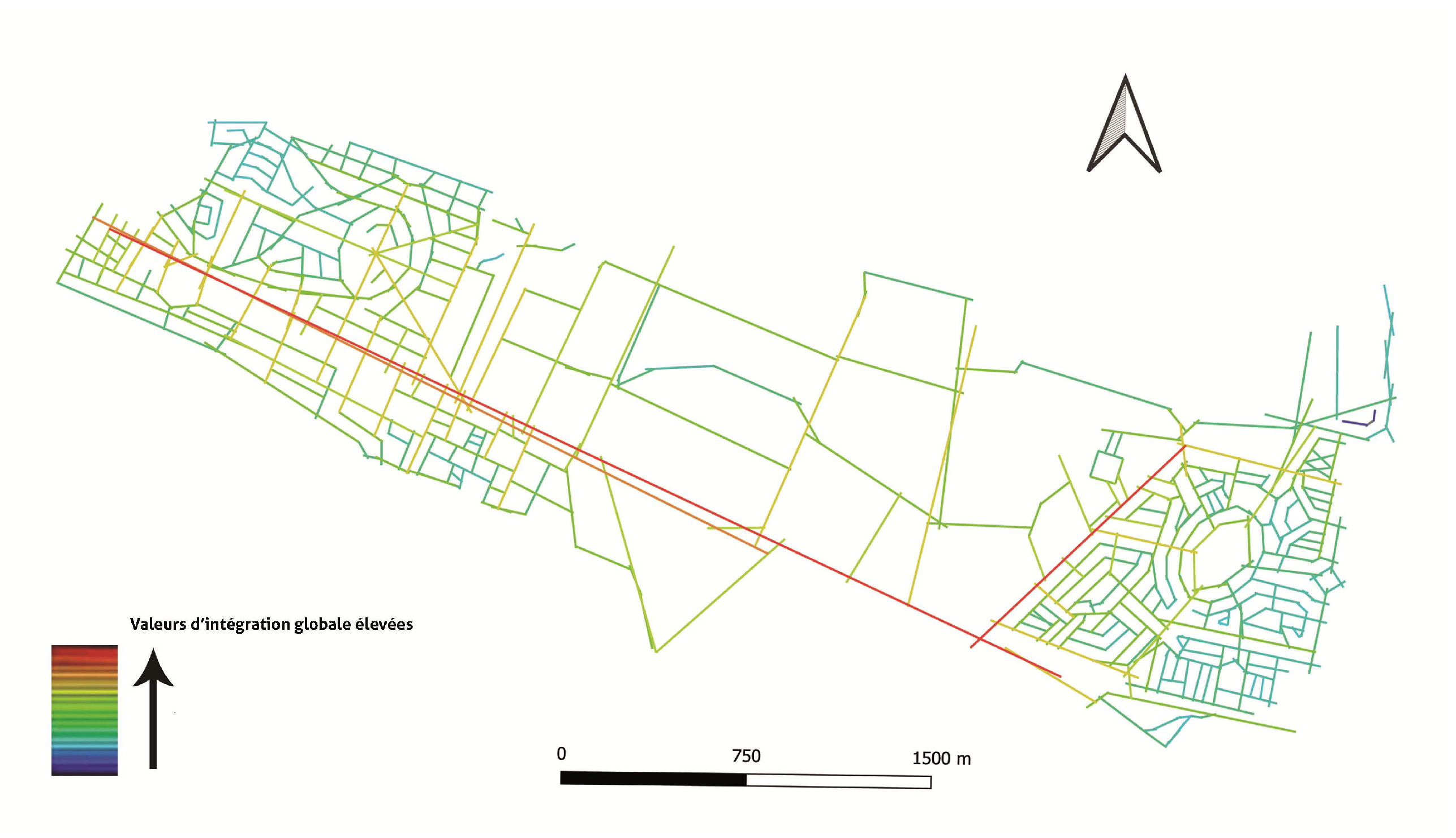
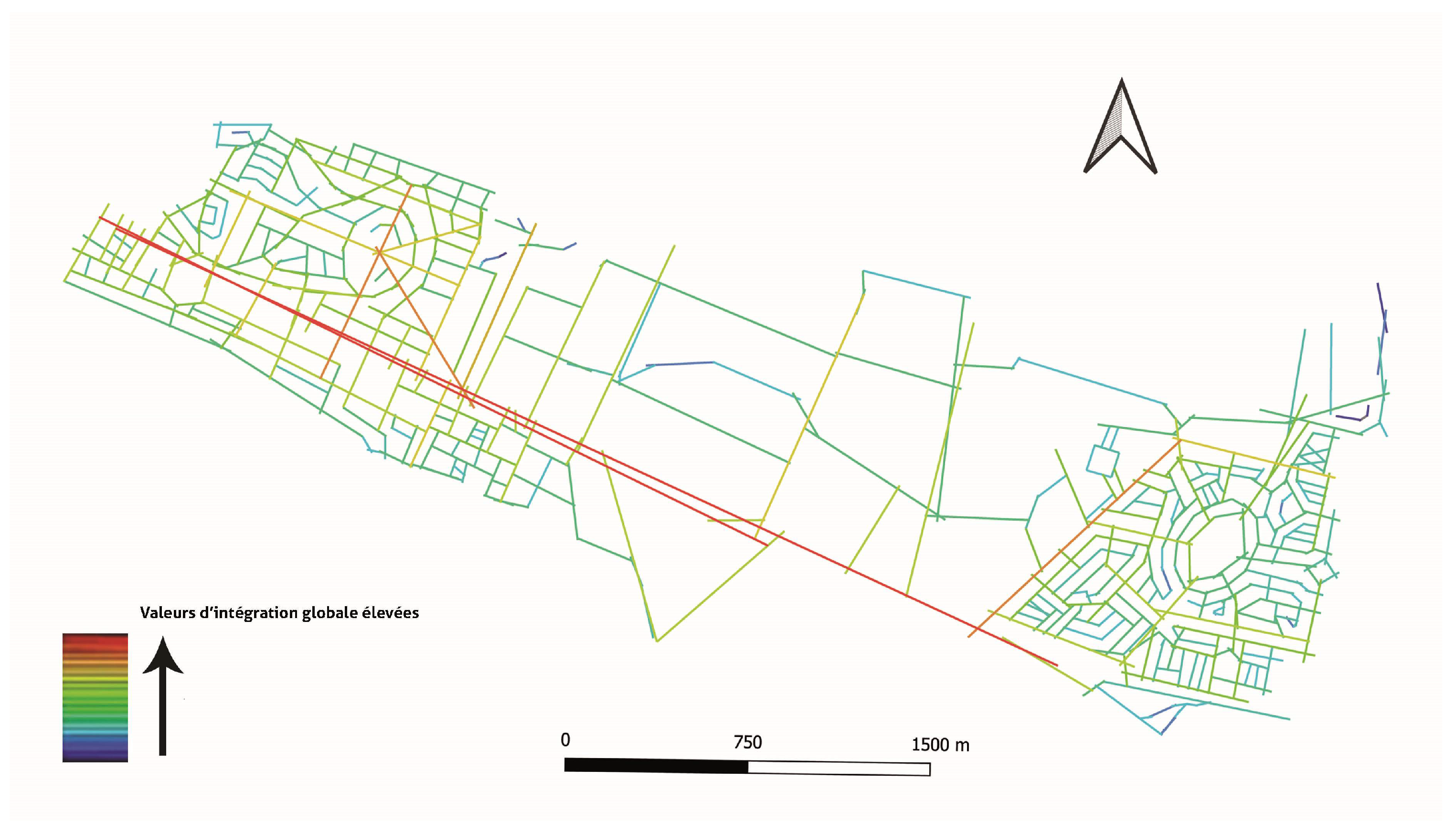
Figure 6 shows the generated axial map of the city with 366 axial lines. The overall integration values vary in a range between 2.496 as the maximum value and 0.210 as the minimum value with an average of 1.309. A high overall integration can be observed at the level of the N1 national road, which represents an important axis of the city. This road N1 has a major importance in the urban network of Bir El Bey. It has the highest integration value of the urban system. This road represents a primary axis of the city, separating a strip of individual housing in the North from a strip of collective housing and an industrial zone in the South.
‘Avenue de la Terre’ presents the second highest level of integration. It is an intermediate value between the most integrated axis RN1 and the adjacent spatial system of lines of low integration to the axial lines serving to the Higher Institute of Cultural Animation of Bir El Bey on the one hand and the sports complex of Borj Cedria on the other hand. The location of the forest, in direct contact with two axes mentioned, gives it an important accessibility. This can be justified by its proximity to urban areas of dense construction, including residential areas, and significant populations go there other than by car.
The segregated areas include the peripheral roads of El Farabi Street in the northwestern sides. They are in the [1.409; 1.681] and [1.681; 1.953] range and are more segregated than the overall urban system (
Table 1). We find in the segregated areas the Higher Institute of Cultural Animation of Bir El Bey and a touristic area. The segregation is accentuated in the northwestern part of the city (roads 17, 18, and 19), mainly the collective housing area. This map is dominated by a strong opposition effect between the center (high values) and the periphery of the city (low values), without any local hierarchy between the types of routes.
The local integration explores the local structural properties, and aims to identify the emergence of secondary centralities, i.e., the accessibility of the forest in relation to the city as a whole. It shows a highly hierarchical spatial distribution. The local integration values range from a maximum of 4.210 to a minimum of 0.210 with an average of 1.940 (
Figure 7).
The results also show that the aspect of accessibility is linear, where we find integrating axes at the local scale. The spatial system of the city seems to have an aspect of centrality in mesh. The major linear axes (a: RN1 National Street, b: ‘Avenue de la Terre’ c: Elfourabi Street) are characterized by very high values. They are in the [3.025; 3.616] and [3.616; 4.210] range and are more integrated than the overall urban system (
Table 1). In contrast, to the sections of the sports facilities area that are less well connected to the network. The analysis also shows that the northwestern part of the city, essentially the collective housing area, is more integrated into the local scale. The axes bordering the forest have high local integration values. The axis of El Fourabi Street seems to be more integrated at the local scale. This can be explained by the presence of vehicular accesses from which citizens can access the forest from secondary streets.
The an analysis of the axial map of overall choice values shows high choice values with an average of 2324.2. The Choice values show that the axis of the RN1 Street is the most connected in the spatial system. This street connects the city of Grombalia to the city of Hammam Lif. It also includes the railway line that connects the city of Hammam Chott to downtown Tunis.
Figure 8 shows another axis that is strongly integrated into the overall spatial system with a choice value of 123,191. The axis of ‘Avenue de la Terre’ constitutes a street that leads to the international camping center and to the sports complex of BorjCédria. Indeed, the important values of choice can be explained by the presence of pedestrian access from which users of the residential area border the forest and the facilities mentioned. The other axis bordering the forest is the axis of El Fourabi Street. It presents average choice values and seems to be more integrated at the local scale. The Choice map shows extremely hierarchical values. The opposition between the choice value of two major axes (a: RN1 National Street, b: ‘Avenue de la Terre’) and the other sections is attenuated (
Table 1).
We also notice a strong value of Choice at the level of the ‘Avenue de la Terre’ and El Fourabi Street. This can be explained by the presence of two pedestrian accesses from the individual and collective housing area in the northeast part, and that can access the forest from the small roads and tracks. The maps also suggested that two major effects play on the distribution of pedestrian accessibility: the opposition between the main axis materialized by the national road and the bordering axes and the hierarchy of local connectivity. However, the accessibility presents a much stronger relationship with the national road, especially in the axes that bypass the urban forest.
Finally, the spatial structure of the city shows an average synergy value of 0.26, which indicates a relatively low correlation between the different integration values, as shown in
Figure 9. Synergy measures the way in which local dynamic relationships are maintained by global dynamics. There are two main reasons for this: on the one hand, the increasing urbanization of the territory of Bir El Bey is reinforced by a very strong demographic growth, and the consequent transformations that occurred on the other hand.
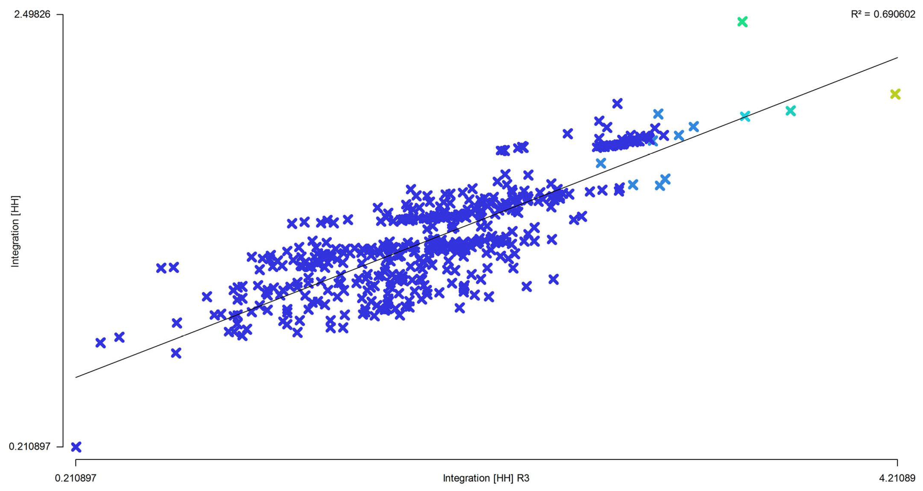
The Intelligibility is also represented in the form of a scatter diagram, correlating the overall spatial integration and connectivity of the axes of the axial map of the city of Hammam Chott. It can be defined as the integration of each space in the whole system. This second-degree measure shows an intelligible system (R² = 0.69) in
Figure 10. The system shows a low synergy, which implies a loss of centrality and a high Intelligibility, resulting from an average global integration system and which implies an accelerated growth of activities in the neighborhood spaces.
The observations of the pedestrian flow were made to verify the correspondence between pedestrian movement and the results of the space syntax axial analysis. These observations establish a good reading of the relationship between spatial configuration and co-presence.
The counts were carried out in mid-season, in the month of March 2021, on a day in the middle of the week, by six observers between 8:00 a.m. and 5:30 p.m. We chose a counting period excluding exceptional events, in the middle of the week, and with relatively mild weather conditions. The movements of residents between their homes and workplaces is taken into consideration as it affects pedestrian and vehicle traffic. The purpose of the count is to measure the pedestrian and vehicular use of the public space. All people using the space are taken into account, whether they are residents, occasional visitors, workers, or others.
The pedestrian and vehicular flows are recorded by a team of observers on various segments of the roads leading to the forest. The observers work in pairs, one to count pedestrians and the other to count vehicles. Each pair of observers is placed on a point on the same street and performs 30-min counts for the five periods below:
- -
Morning Peak Period (8:00–8:30 a.m.);
- -
Mid-day Peak Period (2:00–2:30 p.m.);
- -
Evening Peak Period 2 (5:00–5:30 p.m.).
The pedestrian and vehicle counts provide information on the frequency of use of the routes on the different time periods. The observations are then subjected to descriptive statistics and statistical analysis through the identification of significant correlations between the space syntax measures, integration and controllability, and the vehicular and pedestrian movement records.
The National Road RN1 is characterized by a very high vehicular flow compared to other roads surrounding the forest. It is a connecting road between the southern suburbs and the rest of the city. Vehicle flow decreases considerably on the ’Avenue de la Terre’ and is almost absent on the El Farabi street (
Figure 11). In the East, this is due to the proximity of the Nozhet Soltane housing estate to the bypass that serves the other areas of the city, and in the West, this is due to the absence of facilities and shops and the presence of the fence separating the forest from the residential area, thus transforming the road into a private passage to the residences.
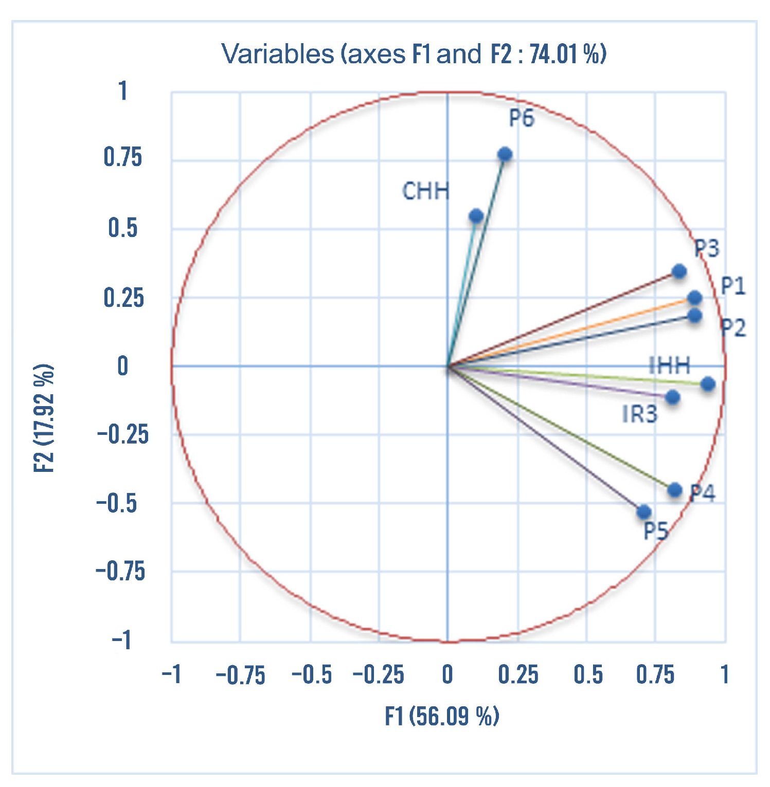
The traffic flow varies according to the time of the day. The principal component analysis (PCA) conducted by XLSTAT exhibits the following main facts. First,
Figure 11 shows the attribute pairs with correlations greater than 0.7, and these are mainly the known cases of correlations between HHI, IR3, and HHC, while cross-relationships with non-syntactic attributes can be shown. The variables P3, P1, and P2 are very strongly positively correlated, while they are negatively correlated with P4 and P5. The variables HH and IR3 are strongly correlated, while the variables CHH and P do not show any correlation with the other variables.
The choice of the two main axes is based on the cumulative percentage of 74% that accounts for the total variance explained. In addition, the first axis depends positively on the different variables, while the second axis depends positively and negatively on the different variables (
Figure 11). This denotes the important role of RN1 in rush hours facilitating to the inhabitants of the southern suburbs of Tunis the transport between housing and work, counting 1100 cars between 8:00 a.m. and 8:30 a.m. and 1600 between 5:00 p.m. and 5:30 p.m. (
Figure 11).
The simultaneous analysis of the observation site and study parameters shows that the most differentiated positions are (1) and (2), respectively. Concerning the contribution of the observations (in our case we treat the two roads), we noticed that the first two roads participate the most in the different axes of analysis and especially the first and second factor. This shows that the first two roads, which are the two peripheral roads of the urban forest, are the most integrated in the whole city layout. One can note that, with the exception of the ES (El Farabi Street) road, the other roads are relatively homogeneous with respect to the two factors (
Figure 12).
On the ‘Avenue de la Terre’, the flow increases in the late afternoon compared to other times of the day. The presence of sports and tourist facilities is justified by the concentration of civil servants returning from work during this time of day. On El Farabi Street, the vehicular flow is greater in the morning and early afternoon than in the late afternoon, as this road serves only the residents of the surrounding neighborhood.
Regardless of the time of day, the pedestrian flow is highest on ‘Avenue de la Terre’, as shown by the PCA analyses (
Figure 12). This road is mainly located near the Borj Cedria metro station, offering easy access to pedestrians (residents, workers, or passengers) coming from the forest or the city of Nozhet Soltane to the whole city of Tunis. It is also extended by a crosswalk provided by a traffic light that facilitates access to the industrial zone to the south.
Figure 12 and
Figure 13 show little pedestrian traffic on Farabi Street due to the absence of activities and commuters. Pedestrian flows in all three sections provide a significant correlation between the presence of a natural landscape and walking activities on the surrounding main streets. For all roads, the pedestrian flow increases at the end of the day. This coincides with the leaving times of the employees who work in the industrial area or in the tourist and sports areas. It is also related to the security conditions that force pedestrians to leave the area before nightfall. This also shows how users become actors in the appropriation of natural spaces in the city of Bir El Bey, gradually defining the forest as a preferred landscape.
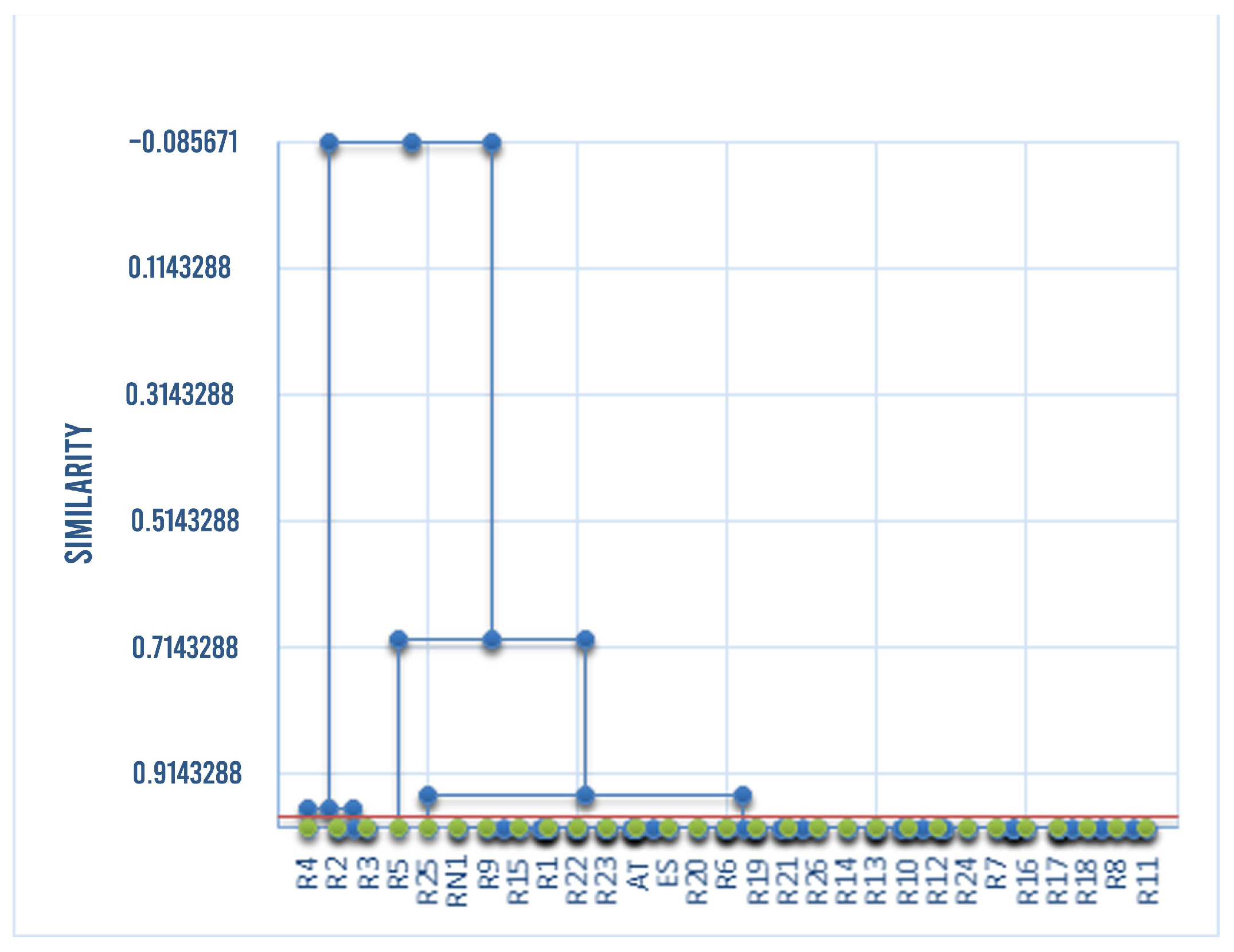
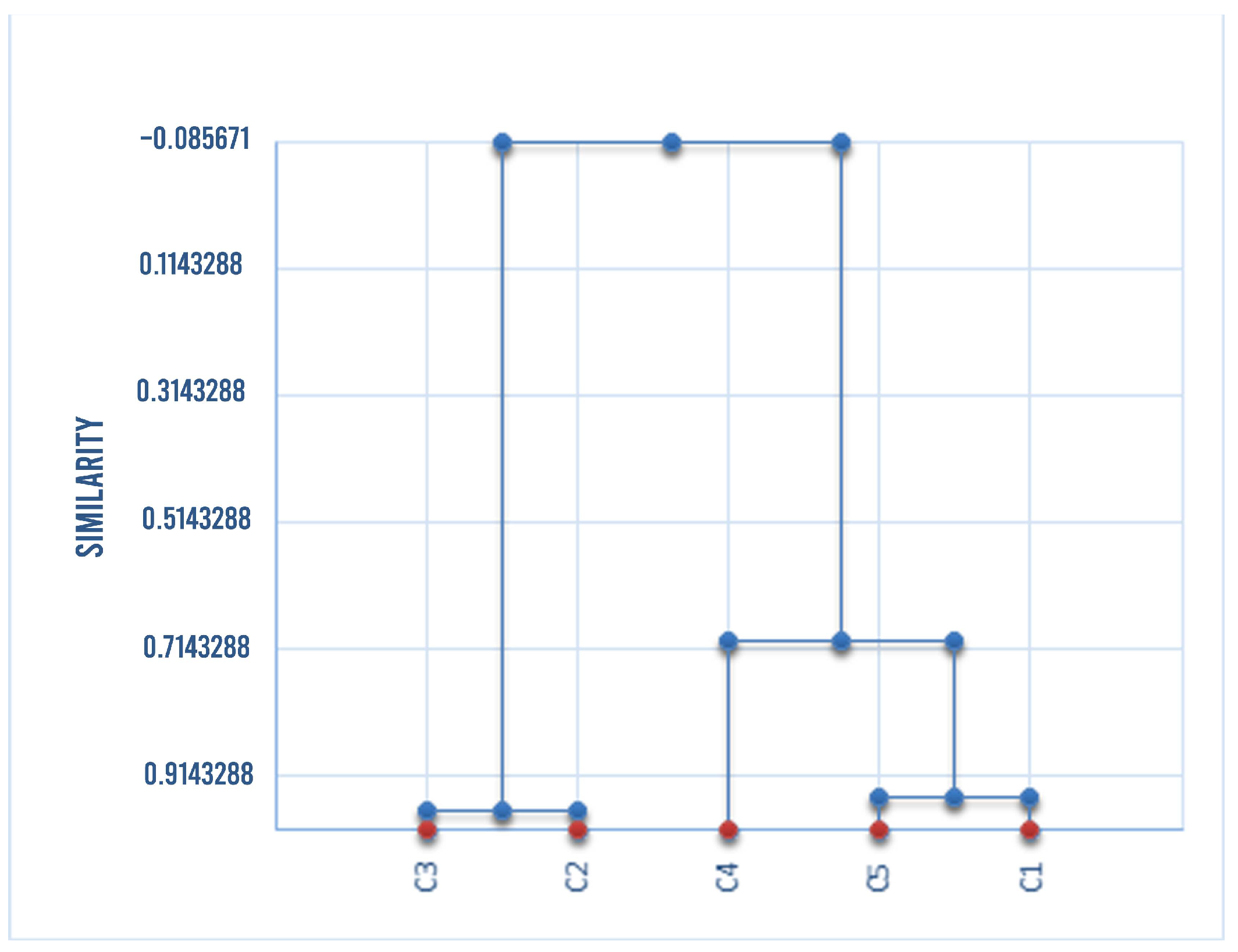
From the AHC classification, indidivuals are grouped according to their similarities in order to represent them in the form of a classification tree so-called dendrogram (
Figure 13). This discrimination brings out five classes, namely: class number 1 integrates the largest number of roads (24 roads) “RN1, AT, ES, R1, R6–R26” and has the highest intra-class variance (169,527,511,587,628) as shown in
Table 2; class number 2 integrates only the two roads R2 and R3. Finally, the other three classes integrate only one road per class. In addition, the majority or the most important information is centered in class number 1 with respect to the factors studied as shown in
Table 2.
The AHC shows that the peripheral streets (RN1, ‘Avenue de la Terre’ and El Farabi Street) belong to class 1 and present the most selected sections in the urban system of Bir El Bey. This is confirmed in the field by the high traffic of the three aforementioned axes. As can be seen, the results are representative enough, thus justifying a possible use of the described methodology as an alternative to the use of traffic observation campaigns. Although all of the analyzed streets are connected to a certain degree of connectivity to RN1, it appears that both El Farabi Street and ‘Avenue de la Terre’ are highly integrated at the global and local levels when compared to the other analyzed streets. Overall, the three peripheral roads are well integrated with their adjacent areas (
Table 1,
Table 2 and
Table 3). The reason for this is that ‘Avenue de la Terre’ has a greater number of pedestrians coming from outside the area and from afar than El Farabi Street. This can be explained not only by the difference in the degree of integration, but also by the presence of connections to this street. This corresponds to the observation that the walking movements of the ‘Avenue de la Terre’ is mainly made of access to the urban forest. The analyses mentioned in
Figure 11 and
Figure 12 show the influence of the presence of a natural area in a built environment on walking patterns, and a valuable example of the impact of land uses on pedestrian patterns in the city.


 and
and 


