
The Use of UAVs for the Characterization and Analysis of Rocky Coasts


1
CRETUS Institute, University of Santiago de Compostela, 15782 Santiago de Compostela, Spain
2
Departament of Geography, Faculty of Geography and History, University of Santiago de Compostela, 15782 Santiago de Compostela, Spain
3
Departament of Soil Science and Agricultural Chemistry, Faculty of Biology, Campus Vida, University of Santiago de Compostela, 15782 Santiago de Compostela, Spain
*
Author to whom correspondence should be addressed.
Drones 2021, 5(1), 23; https://0-doi-org.brum.beds.ac.uk/10.3390/drones5010023
Submission received: 12 February 2021
/
Revised: 2 March 2021
/
Accepted: 5 March 2021
/
Published: 16 March 2021
(This article belongs to the Special Issue Feature Papers of Drones)
Abstract
:Rocky coasts represent three quarters of all coastlines worldwide. These areas are part of ecosystems of great ecological value, but their steep configuration and their elevation make field surveys difficult. This fact, together with their lower variation rates, explains the lower numbers of publications about cliffs and rocky coasts in general compared with those about beach-dune systems. The introduction of UAVs in research, has enormously expanded the possibilities for the study of rocky coasts. Their relative low costs allow for the generation of information with a high level of detail. This information, combined with GIS tools, enables coastal analysis based on Digital Models and high spatial resolution images. This investigation summarizes the main results obtained with the help of UAVs between 2012 and the present day in rocky coastline sections in the northwest of the Iberian Peninsula. These investigations have particularly focused on monitoring the dynamics of boulder beaches, cliffs, and shore platforms, as well as the structure and function of ecosystems. This work demonstrates the importance of unmanned aerial vehicles (UAVs) for coastal studies and their usefulness for improving coastal management. The Galician case was used to explain their importance and the advances in the UAVs’ techniques.
1. Introduction
Rocky coasts are of great importance within the global context. This typology occupies three quarters of all coastlines worldwide, and cliff sections are found in 52% of coastal areas at the global level [1,2]. While these environments could be expected to show lower variation rates than other areas, such as sedimentary systems, they have been found to be characterized by a great dynamism [3]. Although many studies have been performed on rocky coasts, the overall research on these areas has been restricted by several limitations, such as spatial and temporal resolution or the relative importance of different erosion factors, which can generate very different shapes with similar values [2].
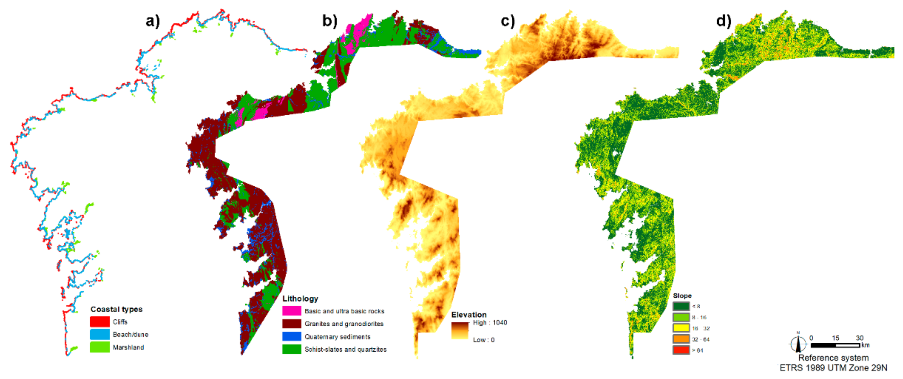
In Spain, coastal cliffs with slopes greater than 32° represent 21.88% of the total coastal area, and 80% of them have elevations below 100 m. These values are relatively similar in Galicia, where 15.29% of cliffs have slopes greater than 32°, and 6% of them have elevations above 200 m at their highest point [4,5]. In this regard, it is worth highlighting that, since rocky coasts show a wide variability, multiple factors affect and modify their characteristics and determine their evolution. In the case of Galicia, those factors are summarized in Figure 1 [4]. Lithological differences, such as different degrees of fracturing, play a key role in cliff behavior, with different lithological types having higher or lower degrees of vulnerability and different degrees of predisposition to the occurrence of mass movements [6,7] or other erosive processes related to bioerosion [8,9].
Another key element in the behavior of coastal systems is the type of structures associated with cliff toes. In this respect, there is a great diversity, ranging from shore platforms to heterometric boulder accumulations and sedimentary beaches [4]. All these elements determine coastal evolution and must be taken into account for any study related to coastal characterization or dynamic analysis. Moreover, the forms present at a given moment are part of the natural heritage, and this can play a relevant role in coastal evolution [10]. Indeed, in the Galician case, it is necessary to understand the past cold processes in order to explain the current coastal landscape [10].
Other factors add to the slower rates of change; among them, it is worth highlighting the difficulties of access, which have historically led to a lower degree of attention from researchers. Moreover, sedimentary areas have generally been considered more important due to their social and economic relevance, which has promoted their study [11]. This lack of attention to rocky coasts has been clearly evidenced by Naylor et al. [12], who reported an increase in this type of work in recent years, covering a wide variety of environments such as shore platforms [11,13], boulder beaches [14,15], and cliffs [16,17].
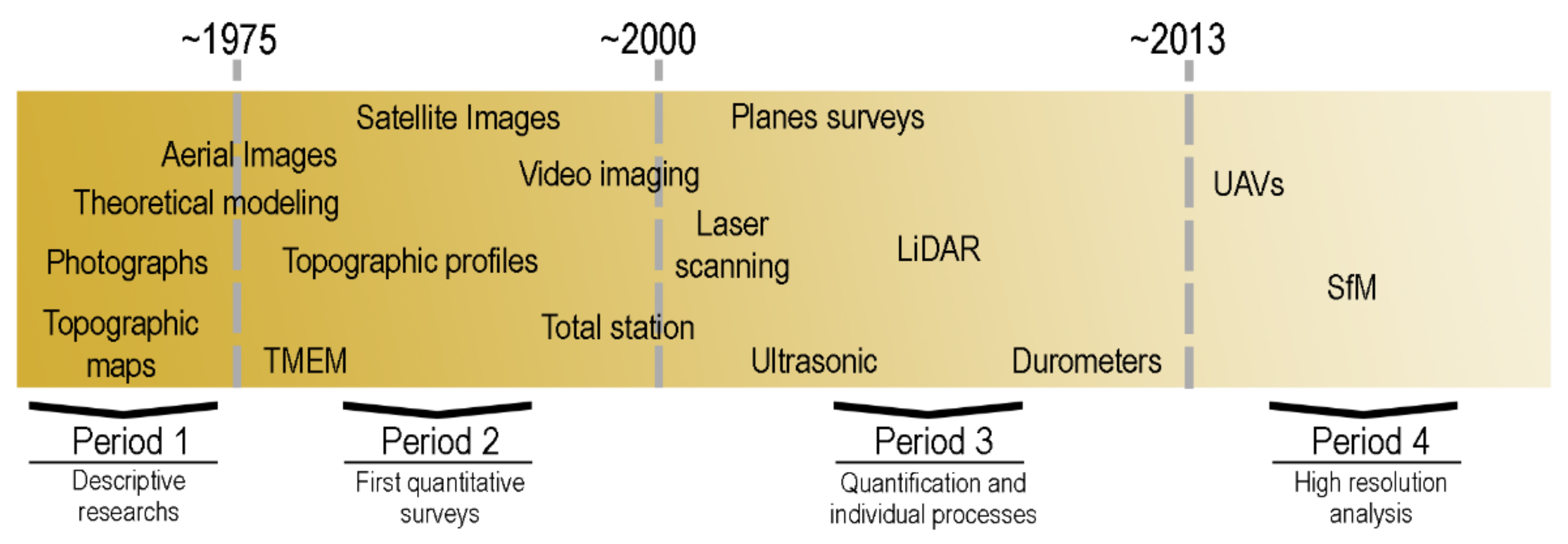
In general terms, the first studies on rocky coasts, performed only a few decades ago, focused on describing study areas by analyzing topographic maps and field surveys [18,19]. These works provided a first approach to the landscape of these areas and an interpretation of their possible evolution. Since then, new techniques and devices have been applied to understand the evolution of rocky coasts, among which the following are worth highlighting: TMEM (transverse micro-erosion meters) [11,20,21,22,23,24], TLS (terrestrial laser scanning) [25,26], LiDAR (light detection and ranging) [27,28,29], hardness testers [30,31,32], aerial and satellite images [33,34,35,36], or sensors as RFID (radio frequency identification) [14,37,38,39] among others (Figure 2).
This improvement in research on rocky coasts has been related to technical and technological advances (Figure 2), which have partly solved the problems associated with measurements in these areas [40]. This fact can be clearly observed in the above-mentioned references, as well as in the diagram represented in Figure 2. The last decade has seen a great improvement both in research in general and in studies on rocky coasts in particular. This improvement has been related to the increasing number of researchers employing UAVs (unmanned aerial vehicles). These have been applied to different fields, such as vegetation analysis [41] or wildfire research [42]. In the context of coastal research, these devices have gained importance in the last decade, allowing for new works about coastal areas in general [43,44] and rocky areas in particular [13,44,45,46], without the need for complicated and expensive field surveys. In this sense, it is worth mentioning the study by Pérez-Alberti et al. [47,48], as the first application of UAVs on rocky coasts, in this case boulder beaches, published in [46]. The use of UAVs allowed quantifying topographic variations and current dynamics with a great level of detail and spatial continuity. This fact was often not possible with classic field surveys, such as topographic profiles, or with aerial images, due to their low spatial and temporal resolution. Even in a novel field such as the use of UAVs on rocky coasts, great technical and methodological advances have taken place, from an early period related to photointerpretation of high resolution images [45,46] to more recent works using photogrammetric techniques such as DSM (digital surface models) generated through SfM (structure from motion) techniques, which enhance the possibilities for quantification [3,49,50,51].
The aim of this research was to emphasize the importance of rocky coasts in general and to analyze how UAVs can improve research about the different environments present in these areas. These allowed for a detailed analysis of the dynamics of boulder beaches, shore platforms, and cliff ecosystems. For this purpose, the results of several studies performed in the last decade using UAVs as a key tool are shown, paying special attention to their methods and results. These investigations summarize the main results obtained in the Galician coast, a sector with a great variability of coastal typologies. These studies allowed understand their usefulness in other sectors with similar characteristics. Moreover, this project provides a review on the evolution of techniques and methodologies applied to the study of rocky coasts and outlines the future of these devices both for general research and for the study of rocky coasts, as a potentially helpful tool for new researchers in rocky coastal environments.
2. Materials and Methods
2.1. Study Areas
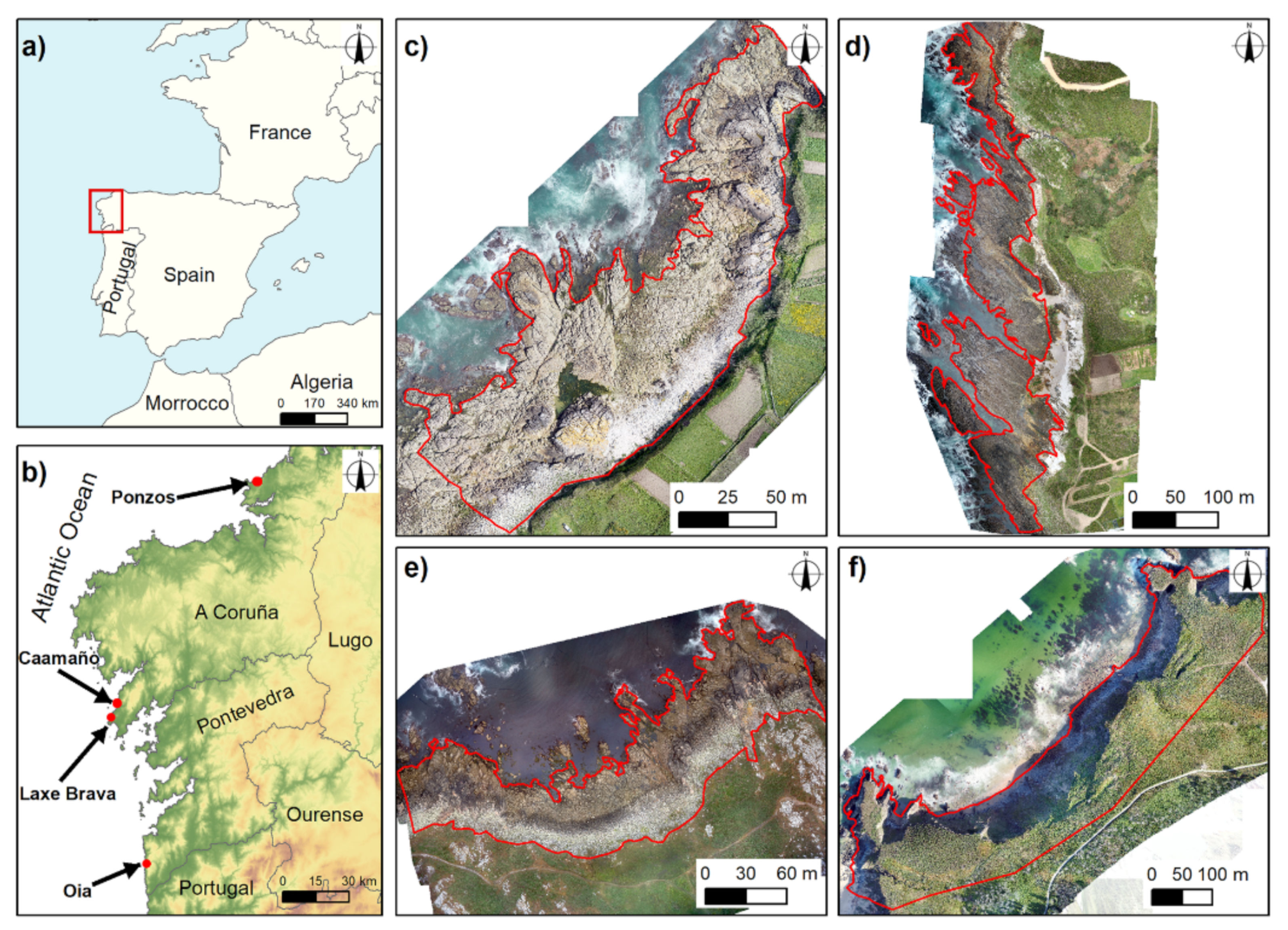
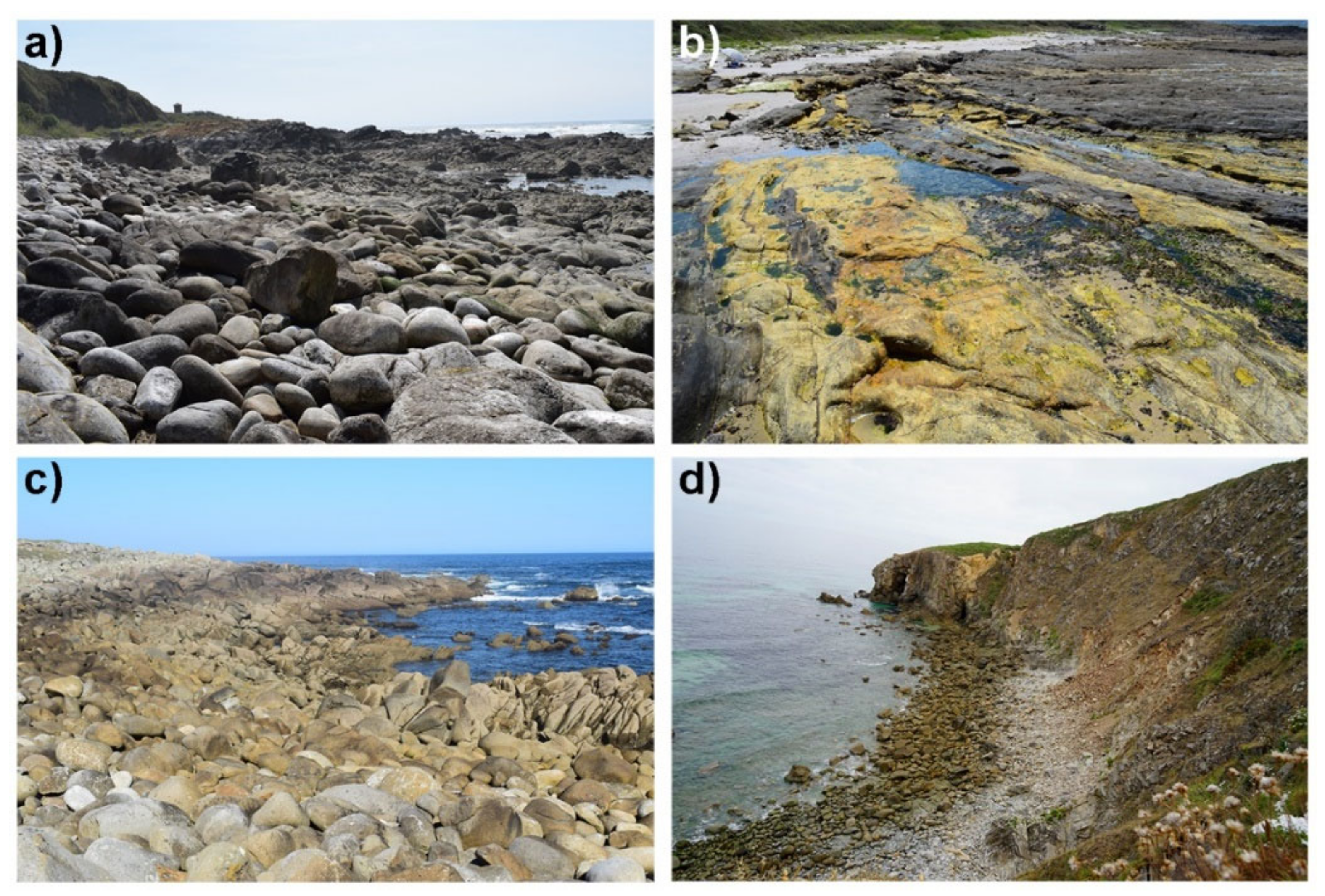
This study is included in a project about rocky coast dynamics and evolution in Galicia (NW Iberian Peninsula) started in 2012 and currently ongoing. The first results have been published in communications by Pérez-Alberti. [47,48]. In this case, four sites were selected for measurement and analysis. Their locations are shown in Figure 3, while Figure 4 shows photographs of the four sites.
2.1.1. Oia (Pontevedra)
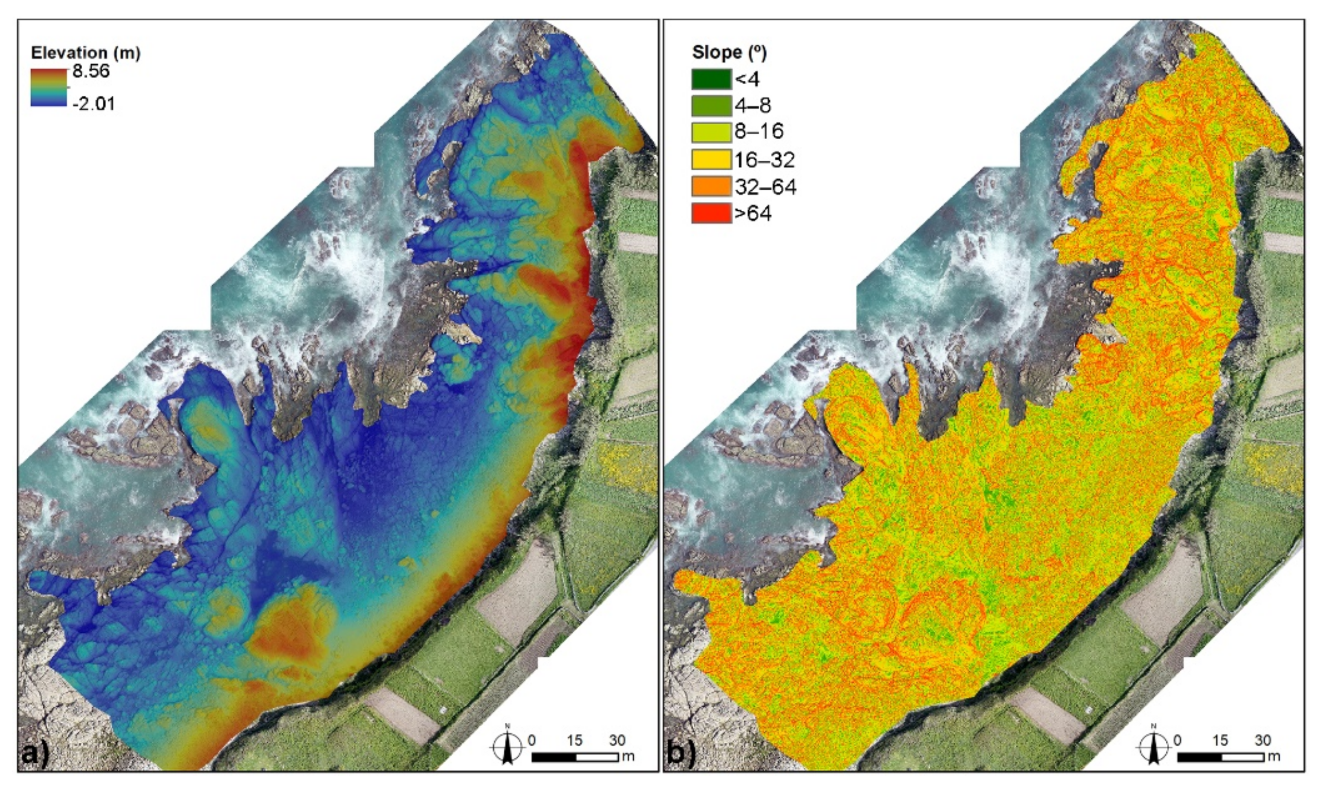
Oia is located in the SW coast of Galicia. This area has been monitored since 2012 [47,48], and previous works have analyzed variations in a natural boulder beach based on information from UAVs using different techniques. It constitutes one of the first areas analyzed with these vehicles. As described in previous works [3,37,47,48], the boulder beach is approximately 20 m wide and 100 m long. This boulder beach is located at the edge of a shore platform and is limited by two rocky promontories to the north and south. The majority of boulders come from the erosion of the back cliff formed by fluvio-nival deposits in a cold environment more than 40,000 years ago [48]. The beach is composed of heterometric boulders, with the largest ones exceeding 60 cm along their major axis, and it sits at the northern section, while decametric clasts are accumulated in the southern section. The substrate is dominated by intensely fractured two-mica granites. This area shows low elevations, reaching 8.56 m at the cliff toe, while a major portion of the shore platform and part of the boulder beach belong to the intertidal level (Figure 5a). Figure 5b shows the slopes of this site, which show a great variability that is clearly related to the boulder accumulations that define their landscape.
Oia is located in a mesotidal region, and the beach is exposed to waves from the northwest, the main direction of waves during winter storms, which are of great importance for the dynamics of this site.
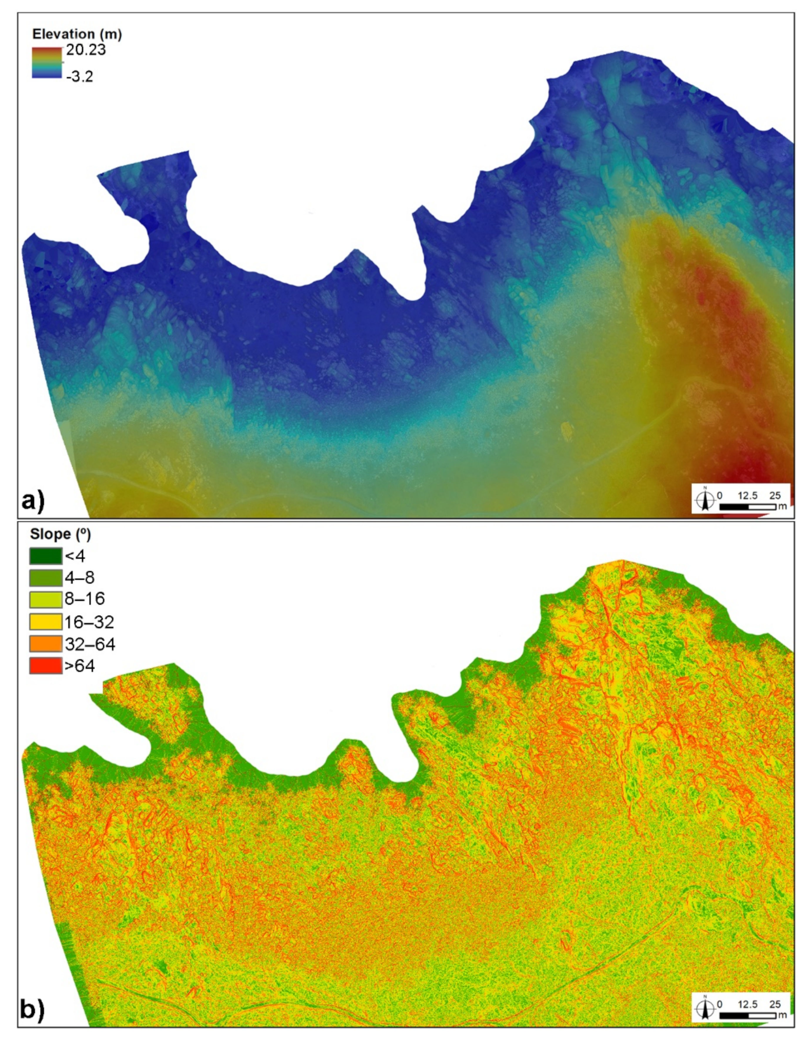
2.1.2. Laxe Brava (A Coruña)
The Laxe Brava site includes a boulder beach associated with a 45–65 m wide shore platform. As in the previous case, this area has been studied in detail using UAVs since 2012, and the first results have been published in communications by Pérez-Alberti [47,48]. This area is fully composed of two-mica granites that, as in the case of Oia, are intensely fractured. The origin of boulders in Laxe Brava is the shore platform and its edge, since no cliffs or any other similar forms that could provide boulders to this beach, are present in the continental area. This origin is related to wave action in the foreshore, combined with frost weathering during glacial periods.
Mean boulder size is 66 cm along the major axis. However, some larger boulders, even exceeding 200 cm in some cases, are found especially in the landward zone, where the current marine influence does not activate these boulders, although some larger boulders located in the most dynamic area have been observed to change positions in recent years. Among these large landward-located boulders are other smaller-sized boulders that have been moved during extreme events in the winter.
Figure 6a shows elevation in this area, which is homogeneous in the active boulder area and reaches 20 m in the distal sections of the platform and along the edge of the study site, which protects part of this area from marine influence. As in the previous case, Figure 6b clearly shows boulder distribution based on their contour in the slope map, which becomes smoother in the landward beach zone.
Laxe Brava is located in one of the most energetic coastal sections of the Iberian Peninsula, where waves above 9 m are frequent during winter storms [46]. As in the case of Oia, their orientation is N-NW; thus, the boulder beach is exposed to the main component of storm waves while being partially protected from SW waves by a rocky promontory located west of the accumulation zone.
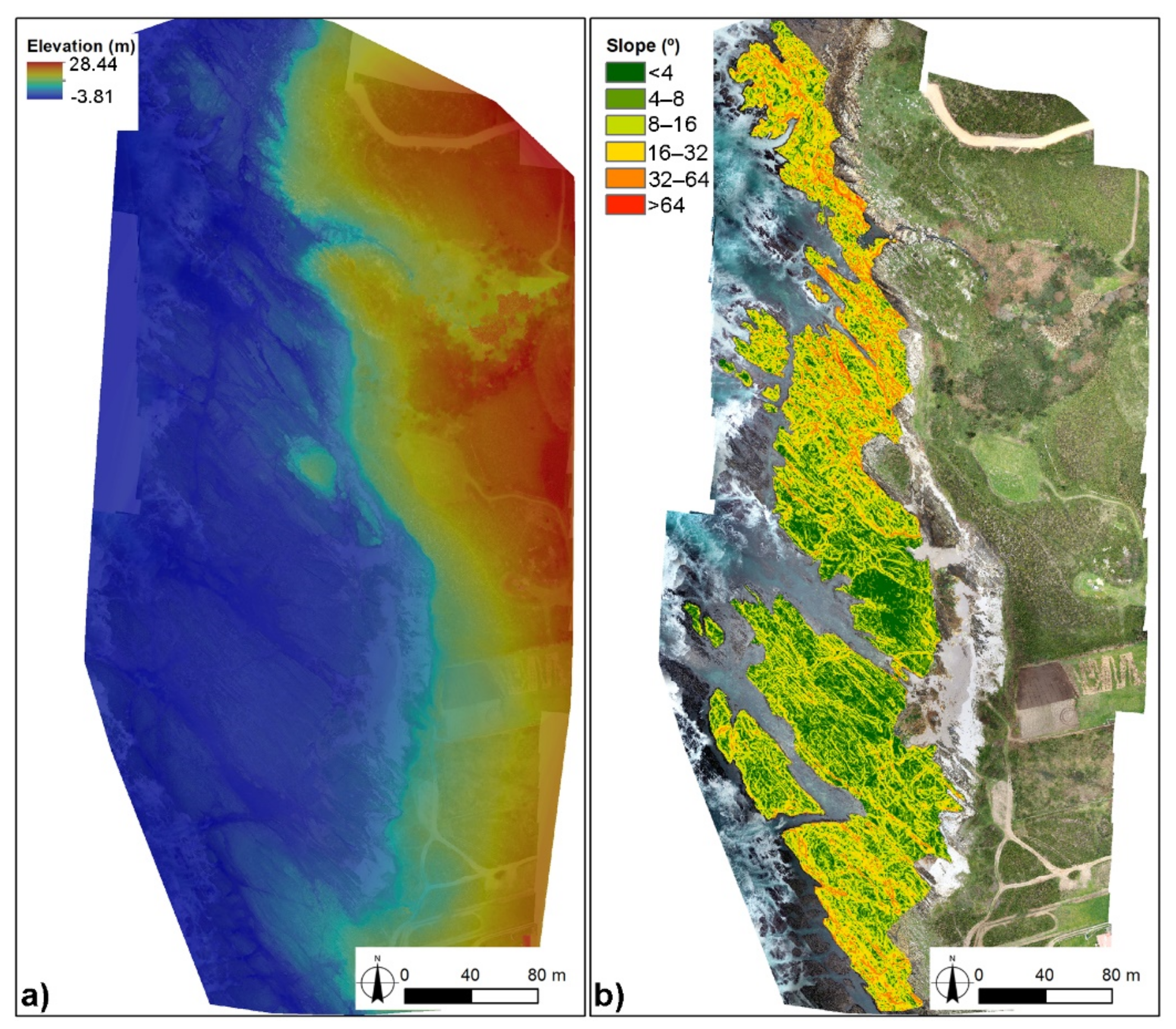
2.1.3. Caamaño (A Coruña)
Like Laxe Brava, the Caamaño site is located in the Barbanza Peninsula. This site is a large, 600 m-long shore platform facing west. Its width varies between 50 and 120 m. This area does not have a main sedimentary deposit, showing only small areas with clasts and sediments cemented by iron and accumulated in small hollows, which stand out amid the mostly horizontal shore platform. This platform is dominated by two-mica granites and schists. This lithological variety adds interest to the analysis of this site, since it allows comparing the behavior of these different rock types when subjected to similar erosive factors.
Figure 7a shows elevation distribution throughout the entire site. In this case, the shore platform area reaches an elevation of 4 m. The highest values occur in the southern area, while elevation is below 3 m in the rest of the shore platform. As for the slope, major differences were observed between the central section, with lower values, and the edges, with the highest slopes (Figure 7b).
The marine influence in this case is similar to that observed in Laxe Brava, with a great impact of winter storms and waves from the NW. The most relevant differences relative to the previous site is orientation: Caamaño does not directly receive the influence of high waves from the NW.
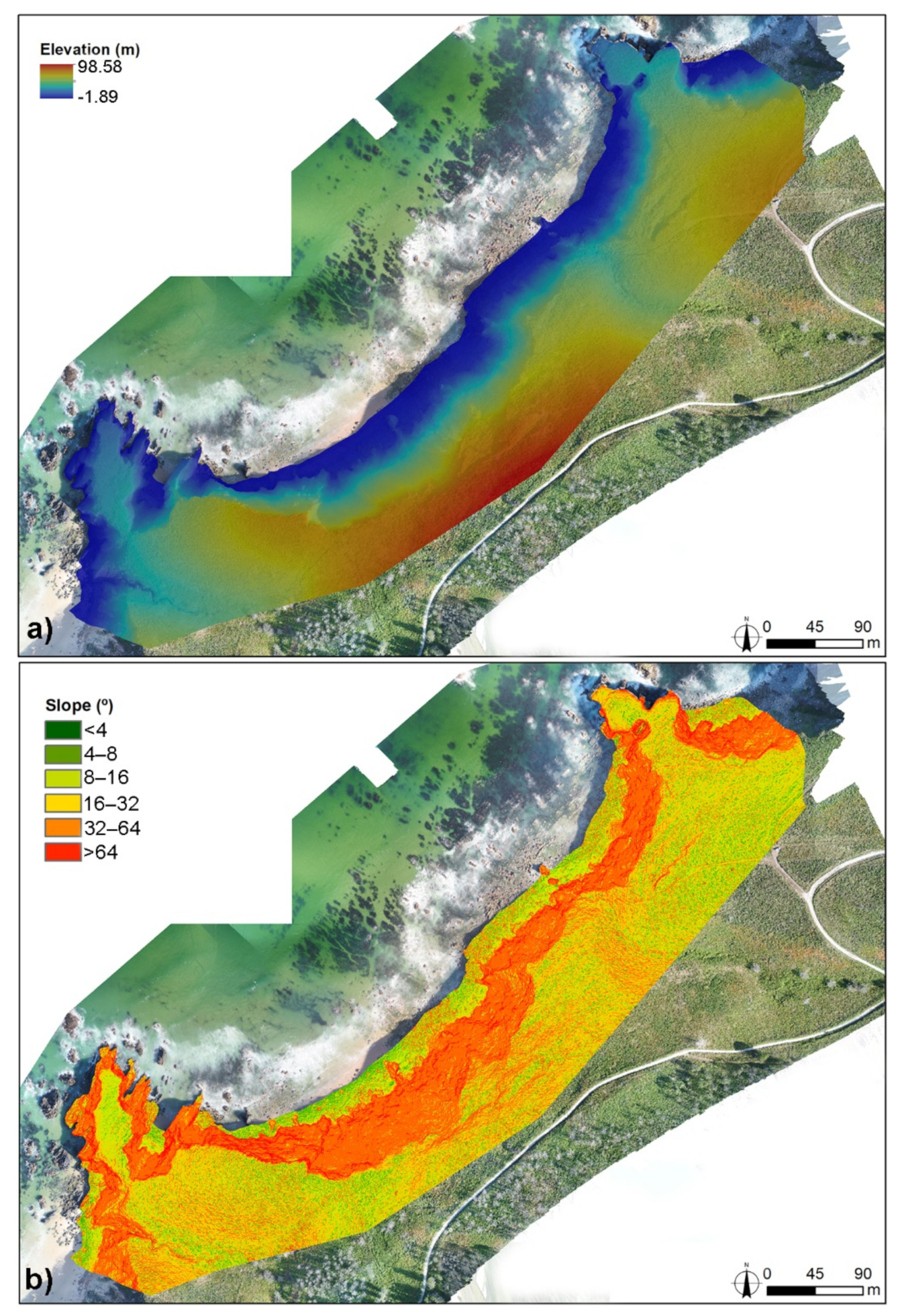
2.1.4. Ponzos (A Coruña)
Ponzos is a cliff site located in the northwestern coast of Galicia, near the city of Ferrol. This area is characterized by cliffs above 50 m with beaches at their base, related to rocky promontories and with a wide lithological heterogeneity. This variety is composed of schists and biotite–muscovite orthogneisses related to paragneisses with a medium and high degree of metamorphism in the southwest edge, as well as small granite seams near schist areas.
In this case, the analysis focused on an 800-m-long section selected as a pilot area to validate different tools for monitoring cliff areas. Figure 8a clearly shows the elevation distribution in this area, with cliffs exceeding 100 m in the central section. Moreover, an analysis of the slopes (Figure 8b) confirmed the wide variety of this zone. These variations are related to the materials accumulated at the cliff toe and to the presence of almost vertical areas, especially in the central section, many of them exceeding 75°.
Ponzos is also located in a high-energy coastline, with a mesotidal level where significant wave height exceeds 5 m for 3.79% of the time during winters. This fact is relevant for the redistribution of materials at the cliff toe and in sedimentary areas in general. Moreover, in order to understand the dynamic of cliffs, it is necessary to take into account that the analyzed section is located in an area where rainfall exceeds 1000 mm/year, with minimum values during the summer.
2.2. Material
All the processes and studies included in this research have as their key element the use of UAVs to characterize and analyze variations in different rocky coasts. It is worth noting that significant changes in UAV devices and associated cameras and in their quality have taken place during the study period. Table 1 summarizes the main characteristics of each flight.
2.3. Methods
The process for image acquisition in the study sites is explained in detail in previous publications [3,45,46] and consisted of the placement of GCPs (ground control points) and their positioning through a GPS device, in this case a Stonex S8 GNSS device. These were used to determine the exact position of the acquired images. The flight area was then defined, and routes were created, along with other parameters such as flight elevation, overlap, and the outline of the analyzed section. After completing the flights, the collected information was processed to yield a comprehensive image of the areas of interest through the generation of a mosaic with UAV photographs and the design of a point cloud to obtain elevation values at each point [45,46].
Once UAV data were processed, various approaches were taken to analyze the areas. First, high-resolution aerial images were used to map the elements present in Oia and Laxe Brava. This approach was based on photointerpretation techniques using ArcGIS (licensed to the USC) to identify variations in the position of thousands of boulders in both sectors [45,46]. This methodology have some problems as the time necessary to mapping all boulders and the uncertainty associated to the person that drawing the boulder contour.
More recent projects have also employed high-resolution images using SfM techniques. This technique was used to generate digital surface models (DSM) to analyze spatial and volumetric variations. based on this information, techniques such as geomorphic change detection (GCD) [52] were applied to identify and quantify differences among several dates, through a raster file with the DEMs of difference (DoD), and to identify the areas with the greater losses or gains during the analyzed period [3,53]. In these analyses a Limit of Detection (LoD) was applied based on the uncertainty of raw data and the processes. This value varied in both sectors, 3.71 cm in Oia and 1.5 cm in Laxe Brava. The uncertainty estimation and its reduction is one of the most important elements to improve these studies.
To characterize shore platforms, high-resolution images and DSMs generated from UAV flights were employed. Photographs were used to distinguish lithologies in the shore platform, while the DSM was used to analyze the elevation, slope, and roughness of these areas. Using both data sources, joints were then traced to analyze platform evolution. In the specific case of Caamaño, this remote information has been complemented with field surveys to identify surface hardness using a durometer (Proceq Equotip 3) [54], thus obtaining a more comprehensive view of the behavior of this site.
In the monitoring of rocky ecosystems, the necessary processes for their correct management are much more costly than in the previous cases in terms of time and resources. As a first approach, variations in the cliff sector were analyzed for two years (2016–2018), detecting mass movements and variations in cliff profiles [52,55]. Moreover, in this case, variations in the cliff top were analyzed to estimate the evolution of the cliff during the aforementioned period using DSAS (Digital Shoreline Analysis System) [55], widely used in coastal studies [56,57,58]. In this sense, this type of study must be complemented with future field surveys by installing sensors to monitor soil humidity or by analyzing the flora and fauna of each site in order to understand their behavior and importance.
3. Evolution of UAVs Studies in Galician Coast and Their Future
3.1. Boulder Beach Dynamics
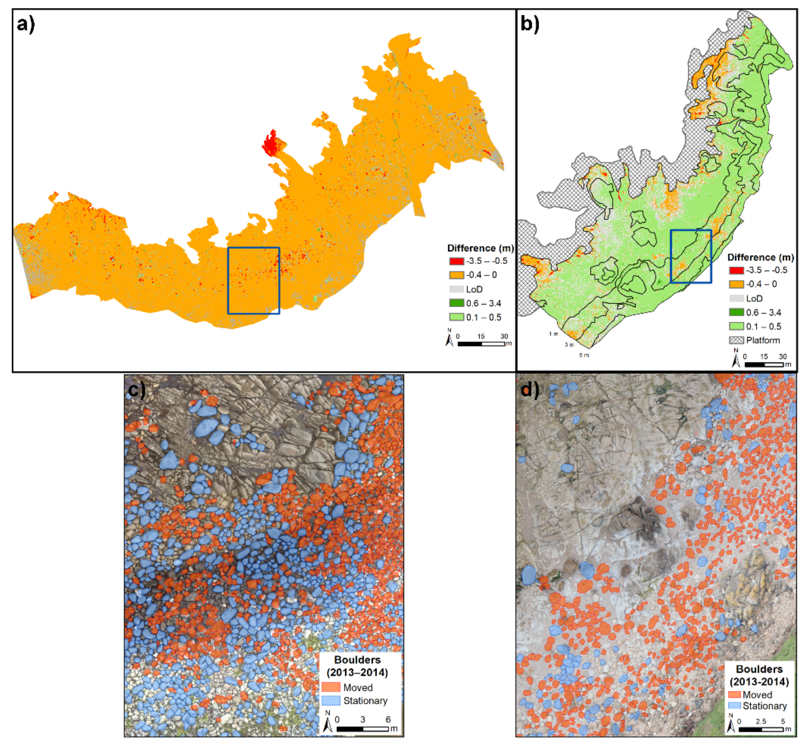
Similar methodologies were applied in the two studied boulder beaches in Galicia, ranging from visual analysis between the winters of 2012–2013 and 2013–2014 [45,46], to more quantitative methods such as the analysis of volumetric variations during the 2014–2016 period [3,53]. The analysis of boulder contour in both sectors revealed differences between Oia and Laxe Brava sites (Figure 9c,d).
The first area showed the highest percentage of relocated boulders. This fact is related to the lower size of boulders. However, size by itself is not sufficient to explain the differences, because in some cases, larger boulders moved while smaller ones remained in place. For this reason, it is essential to understand that the beach environment is key to explaining their dynamics, with a great emphasis on the degree of confinement [37]. Boulder groups could have a more reduced movement capacity, while isolated boulders have a greater degree of freedom to move around.
In the case of Laxe Brava, the number of relocated boulders notably increased from 17.5% to 47.8% between the first and second winter. Movements covering the greatest distances were observed in the seaward zone, between 0 and 4 m, and in the eastern section, where mobility increased between 4 and 6 m. In Oia, the movement rate was greater during the winter of 2013–14 (87.6%) than in the previous winter (53.0%). These variations mainly involved boulders between 0.5 and 6 m in diameter and occurred mainly in the central and northern sections of the study site, far away from the protection of the rocky promontory to the southwest. In both areas, variations were related to the higher frequency of storms during the winter of 2013–14 [59], which promoted boulder mobilization.
In both areas, boulder movement did not occur individually, but rather occurred in groups; this fact led to important variations in beach profile, which is usually 8°. Greater boulder sizes led to steeper beach profiles and, therefore, more energy would be necessary to initiate movement. In this sense, it is worth noting that waves are not the only factor for boulder mobilization; the hydrostatic overload derived from the water mass arriving to the coast is also important. For this reason, major mobility events must be related to storms and wave height, as well as to tides.
Based on the results obtained with the previous method, DSMs were used, focusing on data from the 2014–2016 period. In Laxe Brava, a decrease in elevation was observed throughout almost the whole analyzed site (97.81%), corresponding to a net volume variation of −5141.32 m3. Similarly, to Oia, erosion concentrated in the lower section of the beach, while accretion was limited to small areas, especially in the center of the study area.
In the case of Oia, 80% of the area was found to undergo an accretion process, with erosion concentrated in the seaward sector and with lower variations in the southern part, the most protected from winter storms (Figure 9b). For this period, net difference was 1461.07 m3. The greatest variations occurred in the central section, consistently with findings by previous works [45,46]. The differences in dynamics between both sectors were very similar to those revealed by previous analyses using aerial images and boulder contours (Figure 9a).
One of the main advantages of the latter technique is the collection of continuous data about spatial variations in both areas. This allowed having a more accurate idea about the dynamics affecting these boulder beaches and improved the quantitative results (Table 2). In this sense, it is necessary to highlight the uncertainty associated with this type of analysis due to the presence of spaces between boulders in rocky environments, which affect accretion/erosion values, and which could not be quantified [3,60].
For this type of study, it is necessary to combine these methods with other techniques to improve our understanding of the existing dynamics. In this context, the Oia site has been selected to introduce RFID sensors in recent years. These devices have allowed monitoring the positions of boulders since 2016 and verifying the behavior of this beach as described in the aforementioned studies, therefore leading to a better understanding of their evolutionary dynamics [37].
3.2. Shore Platform Analysis Using UAV Data
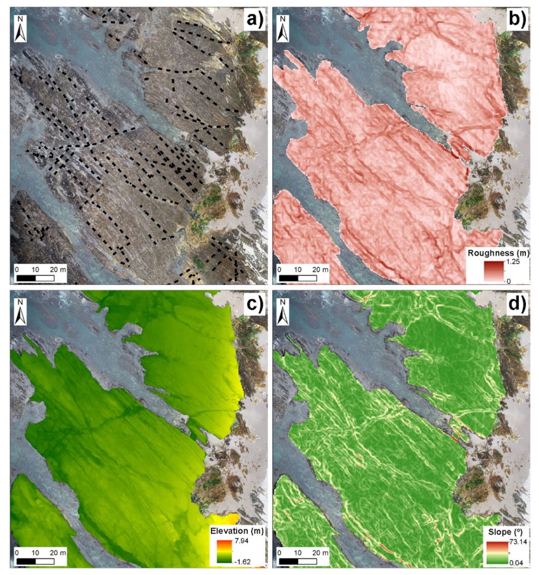
The use of UAVs allowed for the detailed characterization of the Caamaño shore platform. This area shows relevant lithological differences between sections dominated by schists and by granites. In this sense, this study revealed that granitic areas form islands with a higher elevation than their surroundings at the lower part of the shore platform. This is related to the greater resistance to erosion displayed by this type of rock. Moreover, this lithology shows higher degrees of roughness and steeper slopes, a fact that can be qualitatively observed in aerial images, as shown in Figure 4.
Figure 10 summarizes the main characteristics of a specific section of the Caamaño shore platform. First, joints were traced due to their key role in understanding platform evolution and analyzing the more erodible areas. These values are closely related to roughness and slope (Figure 10b,d), which explains the importance of taking these variables into account for shore platform characterization. As for elevation, Figure 10c clearly shows hollow areas in the platform and also allows identifying the most resistant materials by the higher elevations with which they appear.
Taking a closer look at lithological differences, this research demonstrated that granites had high roughness values, especially in the upper platform areas (0.44), while values for schists were similar in all areas (0.32–0.37). Using Proceq Equotip 3, resistance was found to be higher for granite (424.89) than for schist (332.22). These values could be related to remote sensing variables. This type of research not only allows for shore platform characterization [15,61], but, thanks to the detailed examination of their future dynamics [13], it can identify differences in behavior among various lithological types and reveal how physical and biological factors can influence their evolution [8].
3.3. Management of Rocky Ecosystems Using UAV Data
Ecosystem characterization and monitoring are key aspects in the field of coastal management. This study provides a first approach to the evolution of a Galician rocky coastal cliff applying photointerpretation and spatial statistic techniques. Nevertheless, this is only one of the necessary elements for this type of research. To describe ecosystems in detail, it is necessary to generate reports about the species, the floristic and faunal composition, and to analyze trace species that indicate a high environmental quality, as well as to characterize soils and of the degree of anthropization [5]. All these parameters require great efforts in terms of field surveys, which must be performed in different seasons and with a specific frequency to understand the evolution of these sectors.
Despite the great usefulness of UAVs, some analyses could be performed through field surveys to thoroughly understand the areas and the species inhabiting them. However, remote sensing information enabled a close analysis of the evolution of mass movements in this area, as well as of the retreat of cliff tops. Both elements are key parameters to understand ecosystem evolution and functionality. The improvement of technologies in the last decades had a great importance in this field, with an important increase in accuracy level [62,63].
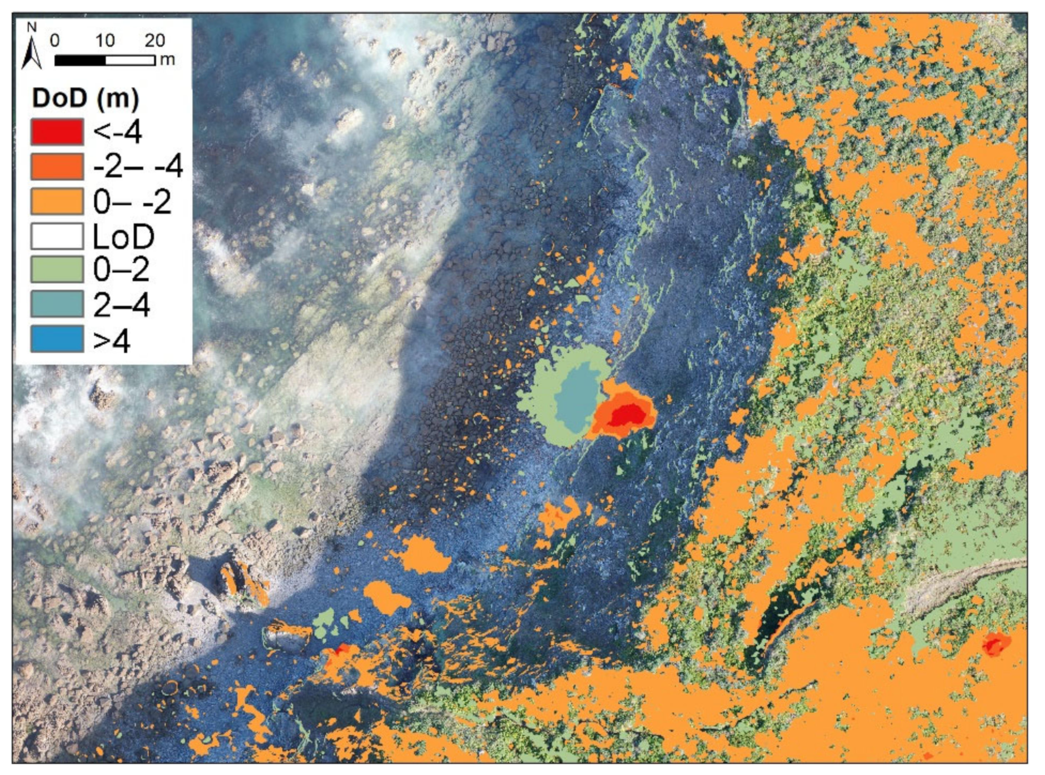
In this project, an important dynamism could be observed in the Ponzos site, with major landslides affecting the cliff section and mobilizing more than 4000 m3 of material in two years (Figure 11). A similar dynamic was observed regarding cliff-top behavior, with a mean retreat of 0.9 m. Other areas found along the coastline are vulnerable to factors such as rock fracturing, sediment accumulation at cliff toes, or rainfall [5]. It is worth emphasizing the importance of continental factors in the alteration of cliff areas, among which rainfall accumulation is a fundamental element to understanding mass movements [64].
The mass movements occurred in the south sector zone during the analyzed period have been outlined. Other mass movements have previously appeared in this area, and further analyses are required in order to understand their evolution [65]. In this sense, UAVs are a fundamental tool to identify cliff dynamics and, therefore, to improve coastal management thanks to the creation of inventories of the most vulnerable areas [64,66], while avoiding activities that could potentially be dangerous for the area’s inhabitants and infrastructures.
UAVs can be extremely useful to estimate vegetation status and soil humidity in this type of research. For these purposes, multiband cameras enable a quantitative approach [67].
3.4. Improvements in Research with the Use of UAVs
The arrival of UAVs to coastal geomorphology research has two main elements. The first, as already mentioned, is related to an improvement in spatial resolution. In addition, the relatively low cost of these devices allows for faster image acquisition and for a more comprehensive temporal coverage in comparison with other technologies such as satellite or aerial images [68,69,70]. This improvement currently enables detailed analyses of the influence of marine and continental factors on the evolution of rocky areas, thanks to the possibility of surveying study areas between storms or after extreme rainfall events [71,72]. Moreover, in coastal cliffs or steep slopes, other data sources (e.g., satellite or aerial images) do not allow a detailed analysis about their dynamics. In steep zones, the pixel size of these images avoids the variations identification.
The application of UAVs to geomorphological studies and, more generally, to studies about ecosystem behavior did not initially target rocky coasts, nor are these the most relevant areas in this field. Nowadays, multiple studies have used UAVs to monitor sedimentary systems [73,74], vulnerable areas as coastal lagoons [75], saltmarshes [76], mangroves [77], estuaries [78], and other coastal areas that require detailed analysis [79,80,81], as well as in the general coastal context [68,73].
All the aforementioned sectors had been previously studied, but the technical advances associated with UAVs have improved the time series and have allowed acquiring better and more accurate qualitative data at mesoscale. These facts have allowed expanding the knowledge about the natural environment in general and about rocky coasts in particular.
3.5. The Future of UAVs in Coastal Research
Based on the number of projects generated in the last decade and on their relevance, it is clear that the increase in coastal research using UAVs will continue to follow a positive trend in the near future. The wide possibilities of their associated methodologies, together with fast data acquisition and low costs, have promoted their use, especially in sectors where field surveys are not easy to perform either due to costs or to other factors.
It is worth emphasizing the importance of combining the information obtained through UAVs with other data to improve results and generate better and more accurate explanations about coastal evolution. In line with this, it is worth emphasizing the combined use of instruments such as durometers in shore platforms, which, together with DSM analysis, can expand our knowledge about these areas and their evolution. In the case of Oia, the information acquired by the flight was merged with data obtained by other techniques, such as RFID sensors, to determine the directions and measure the distances of boulder movements. This combination of information from different sources helps to understand the variations observed in DSMs [37].
Moreover, as has been observed in other fields such as in wildfire research [82], UAVs are likely to constitute a key tool to monitor coastal environments in the future. They could play an important role in improving coastal management projects by updating the actions applied in protected spaces and other sensitive areas according to variations related to global change. It is precisely in relation to global change and its consequences where UAVs could be of great importance to analyze how alterations in physical factors could impact the territory.
In relation to the aforementioned, research carried out on cliffs, shore platforms, and boulder beaches has revealed the importance of understanding soil temperature and humidity for rock alteration processes, particularly at the start of mass movements in cliff areas. For this reason, multiband sensors in UAVs could be immensely useful to monitor sectors such as Ponzos during heavy rainfall periods. The use of multispectral sensors is a logical evolution that will allow analyzing seasonal variations in vegetation, as well as soil characteristics, such as humidity or other physicochemical parameters, to understand landscape evolution in detail [67,83,84].
4. Conclusions
This study shows the importance of UAVs for rocky coastal research. These instruments have allowed for a detailed analysis of the dynamics affecting rocky coasts.
The associated methodologies allowed confirming the high dynamism of rocky areas, such as boulder beaches, by measuring variations in the position of elements or volumetric differences. These studies allow comparing near sectors to understand the factors controlling their dynamics and explain the possible differences (e.g., the behavior in Oia and Laxe Brava during the same period).
The use of UAVs combined with other techniques is of enormous value to expand the knowledge about rocky coasts. As previously observed, their combination with field surveys in accessible areas is of crucial importance for a correct environmental characterization. Clear examples of this are shore platforms, where the relation with durometer values allows a more realistic approach to the platform characteristics, and boulder beaches, where currently the use of UAVs are related to RFID sensors. This combination improves the knowledge about the boulders displacements.
The techniques employed, as well as the uncertainty associated with these analyses, could be improved in the future by increasing processing capabilities and by performing more studies using similar techniques. In this sense, the application of multispectral cameras could greatly impact our understanding of coastal areas.
The use of UAVs for ecosystem monitoring and coastal management is expected to increase in the future within the context of global change. These devices allow an accurate characterization of land uses and ecosystems distribution.
Author Contributions
Conceptualization: A.G.-P. and A.P.-A.; methodology: A.G.-P. and A.P.-A.; formal analysis: A.G.-P.; investigation: A.G.-P. and A.P.-A.; writing—original draft preparation: A.G.-P. and A.P.-A.; writing—review and editing: A.G.-P. and A.P.-A. All authors have read and agreed to the published version of the manuscript.
Funding
A.G.-P. is supported by an FPU predoctoral contract by the Spanish government (Ministerio de Educación, Cultura y Deporte). Grant Number: FPU16/03050. This work was supported by CRETUS Institute.
Data Availability Statement
Data sharing not applicable.
Acknowledgments
This work was supported by CRETUS Institute. A.G-P. was in receipt of an FPU predoctoral contract with reference FPU16/03050.
Conflicts of Interest
The authors declare no conflict of interest.
References
- Bird, E.C.F. Coastal Geomorphology: An Introduction, 2nd ed.; John Wiley & Sons: Chichester, UK, 2008; ISBN 9780470723968. [Google Scholar]
- Young, A.P.; Carilli, J.E. Global distribution of coastal cliffs. Earth Surf. Process. Landf. 2019, 44, 1309–1316. [Google Scholar] [CrossRef] [Green Version]
- Gómez-Pazo, A.; Pérez-Alberti, A.; Trenhaile, A. Recording inter-annual changes on a boulder beach in Galicia, NW Spain using an unmanned aerial vehicle. Earth Surf. Process. Landf. 2019, 44, 1004–1014. [Google Scholar] [CrossRef]
- Perez-Alberti, A.; Gomez-Pazo, A. The Rocky Coasts of Northwest Spain. In The Spanish Coastal Systems; Springer: Berlin/Heidelberg, Germany, 2019; pp. 27–47. ISBN 9783319931692. [Google Scholar]
- Aranda, M.; Gracia, F.J.; Pérez-Alberti, A. Selección y Descripción de Variables que Permitan Diagnosticar el Estado de Conservación del Parámetro ‘Estructura y Función’ de los Diferentes Tipos de Hábitat Costeros; Ministerio para la Transición Ecológica: Madrid, Spain, 2019. [Google Scholar]
- Marques, F. Regional Scale Sea Cliff Hazard Assessment at Sintra and Cascais Counties, Western Coast of Portugal. Geosciences 2018, 8, 80. [Google Scholar] [CrossRef] [Green Version]
- Del Río, L.; Gracia, F.J.; Benavente, J. Mass Movements and Cliff Retreat along the SW Spanish Coast. J. Coast. Res. 2009, SI, 717–721. [Google Scholar]
- Naylor, L.A.; Coombes, M.A.; Viles, H.A. Geomorphology Reconceptualising the role of organisms in the erosion of rock coasts: A new model. Geomorphology 2012, 157–158, 17–30. [Google Scholar] [CrossRef]
- Naylor, L.A.; Viles, H.A.; Carter, N.E.A. Biogeomorphology revisited: Looking towards the future. Geomorphology 2002, 47, 3–14. [Google Scholar] [CrossRef]
- Pérez-Alberti, A.; Blanco-Chao, R.; Vázquez, M.; Valcárcel, M. Dinámica y evolución de las costas rocosas. El ejemplo de Galicia. In Geomorfología Litoral. Procesos Activos; de Andrés, J.R., Gracia, F.J., Eds.; ITGME. Ministerio de Ciencia y Tecnología: Madrid, Spain, 1999; pp. 175–185. [Google Scholar]
- Trenhaile, A.S. The effect of Holocene changes in relative sea level on the morphology of rocky coasts. Geomorphology 2010, 114, 30–41. [Google Scholar] [CrossRef]
- Naylor, L.A.; Stephenson, W.J.; Trenhaile, A.S. Rock coast geomorphology: Recent advances and future research directions. Geomorphology 2010, 114, 3–11. [Google Scholar] [CrossRef]
- Swirad, Z.M.; Rosser, N.J.; Brain, M.J. Identifying mechanisms of shore platform erosion using Structure-from-Motion (SfM) photogrammetry. Earth Surf. Process. Landf. 2019, 44, 1542–1558. [Google Scholar] [CrossRef] [Green Version]
- Hastewell, L.; Inkpen, R.; Bray, M.; Schaefer, M. Quantification of contemporary storm-induced boulder transport on an intertidal shore platform using radio frequency identification technology. Earth Surf. Process. Landf. 2020, 45, 1601–1621. [Google Scholar] [CrossRef]
- Perez-Alberti, A.; Trenhaile, A.S.; Pires, A.; Lopez-Bedoya, J.; Chamine, H.I.; Gomes, A. The effect of boulders on shore platform development and morphology in Galicia, north west Spain. Cont. Shelf Res. 2012, 48, 122–137. [Google Scholar] [CrossRef]
- Mancini, F.; Castagnetti, C.; Rossi, P.; Dubbini, M.; Fazio, N.L.; Perrotti, M.; Lollino, P. An integrated procedure to assess the stability of coastal rocky cliffs: From UAV close-range photogrammetry to geomechanical finite element modeling. Remote Sens. 2017, 9, 1235. [Google Scholar] [CrossRef] [Green Version]
- Vann Jones née Norman, E.C.; Rosser, N.J.; Brain, M.J.; Petley, D.N. Quantifying the environmental controls on erosion of a hard rock cliff. Mar. Geol. 2015, 363, 230–242. [Google Scholar] [CrossRef] [Green Version]
- Blanco Chao, R.; Pérez Alberti, A. Formas litorales en la costa noroccidental gallega: Los sectores acantilados entre Cabo Prioriño (Ferrol) y Punta Frouxeira (Valdoviño). Geographicalia 1996, 33, 3–28. [Google Scholar] [CrossRef] [Green Version]
- Sunamura, T. Geomorphology of Rocky Coasts; Wiley: Chichester, UK, 1992; ISBN 0471917753. [Google Scholar]
- Naylor, L.A.; Stephenson, W.J. On the role of discontinuities in mediating shore platform erosion. Geomorphology 2010, 114, 89–100. [Google Scholar] [CrossRef]
- Inkpen, R.J.; Stephenson, W. Statistical analysis of the significance of site topography and erosion history on erosion rates on intertidal shore platforms, Kaikoura Peninsula, South Island, New Zealand. Geomorphology 2006, 81, 18–28. [Google Scholar] [CrossRef]
- Stephenson, W.J.; Finlayson, B.L. Measuring erosion with the micro-erosion meter-Contributions to understanding landform evolution. Earth Sci. Rev. 2009, 95, 53–62. [Google Scholar] [CrossRef]
- Stephenson, W.J.; Kirk, R.M.; Hemmingsen, S.A.; Hemmingsen, M.A. Decadal scale micro erosion rates on shore platforms. Geomorphology 2010, 114, 22–29. [Google Scholar] [CrossRef]
- Trudgill, S.T. The subaerial and subsoil erosion of limestones on Aldabra Atoll, Indian Ocean. Z. Geomopholgie 1976, 26, 201–210. [Google Scholar]
- Letortu, P.; Costa, S.; Maquaire, O.; Delacourt, C.; Augereau, E.; Davidson, R.; Suanez, S.; Nabucet, J. Retreat rates, modalities and agents responsible for erosion along the coastal chalk cliffs of Upper Normandy: The contribution of terrestrial laser scanning. Geomorphology 2015, 245, 3–14. [Google Scholar] [CrossRef]
- Jaud, M.; Letortu, P.; Théry, C.; Grandjean, P.; Costa, S.; Maquaire, O.; Davidson, R.; Le Dantec, N. UAV survey of a coastal cliff face—Selection of the best imaging angle. Meas. J. Int. Meas. Confed. 2019, 139, 10–20. [Google Scholar] [CrossRef] [Green Version]
- Matsumoto, H.; Dickson, M.E.; Masselink, G. Systematic analysis of rocky shore platform morphology at large spatial scale using LiDAR-derived digital elevation models. Geomorphology 2017, 286, 45–57. [Google Scholar] [CrossRef]
- Le Mauff, B.; Juigner, M.; Ba, A.; Robin, M.; Launeau, P.; Fattal, P. Coastal monitoring solutions of the geomorphological response of beach-dune systems using multi-temporal LiDAR datasets (Vendée coast, France). Geomorphology 2018, 304, 121–140. [Google Scholar] [CrossRef]
- Thébaudeau, B.; Trenhaile, A.S.; Edwards, R.J. Modelling the development of rocky shoreline profiles along the northern coast of Ireland. Geomorphology 2013, 203, 66–78. [Google Scholar] [CrossRef] [Green Version]
- Aoki, H.; Matsukura, Y. A new technique for non-destructive field measurement of rock-surface strength: An application of the Equotip hardness tester to weathering studies. Earth Surf. Process. Landf. 2007, 32, 1759–1769. [Google Scholar] [CrossRef] [Green Version]
- Viles, H.; Goudie, A.; Grab, S.; Lalley, J. The use of the Schmidt Hammer and Equotip for rock hardness assessment in geomorphology and heritage science: A comparative analysis. Earth Surf. Process. Landf. 2011, 36, 320–333. [Google Scholar] [CrossRef]
- Feal-Pérez, A.; Blanco-Chao, R. Characterization of abrasion surfaces in rock shore environments of NW Spain. Geo Mar. Lett. 2013, 33, 173–181. [Google Scholar] [CrossRef]
- Lim, M.; Rosser, N.J.; Allison, R.J.; Petley, D.N. Erosional processes in the hard rock coastal cliffs at Staithes, North Yorkshire. Geomorphology 2010, 114, 12–21. [Google Scholar] [CrossRef]
- Cenci, L.; Disperati, L.; Persichillo, M.G.; Oliveira, E.R.; Alves, F.L.; Phillips, M. Integrating remote sensing and GIS techniques for monitoring and modeling shoreline evolution to support coastal risk management. GISci. Remote Sens. 2018, 55, 355–375. [Google Scholar] [CrossRef]
- Federici, B.; Corradi, N.; Ferrando, I.; Sguerso, D.; Lucarelli, A.; Guida, S.; Brandolini, P. Remote sensing techniques applied to geomorphological mapping of rocky coast: The case study of Gallinara Island (Western Liguria, Italy). Eur. J. Remote Sens. 2019, 52, 123–136. [Google Scholar] [CrossRef] [Green Version]
- Horikawa, K.; Sunamura, T. A study on erosion of coastal cliffs by using aerial photographs. Coast. Eng. Jpn. 1967, 10, 67–83. [Google Scholar] [CrossRef]
- Gómez-Pazo, A.; Pérez-Alberti, A.; Trenhaile, A. Tracking clast mobility using RFID sensors on a boulder beach in Galicia, NW Spain. Geomorphology 2021, 373, 107514. [Google Scholar] [CrossRef]
- Hastewell, L.J.; Schaefer, M.; Bray, M.; Inkpen, R. Intertidal boulder transport: A proposed methodology adopting Radio Frequency Identification (RFID) technology to quantify storm induced boulder mobility. Earth Surf. Process. Landf. 2019, 44, 681–698. [Google Scholar] [CrossRef] [Green Version]
- Casamayor, M.; Alonso, I.; Cabrera, J.; Rodríguez, S.; Sánchez-García, M. Long term recovery rates obtained using RFID technology at a mixed beach. Geol. Acta 2015, 13, 85–96. [Google Scholar] [CrossRef]
- Viles, H. Technology and geomorphology: Are improvements in data collection techniques transforming geomorphic science? Geomorphology 2016, 270, 121–133. [Google Scholar] [CrossRef]
- Masek, J.G.; Hayes, D.J.; Joseph Hughes, M.; Healey, S.P.; Turner, D.P. The role of remote sensing in process-scaling studies of managed forest ecosystems. For. Ecol. Manag. 2015, 355, 109–123. [Google Scholar] [CrossRef] [Green Version]
- Cruz, H.; Eckert, M.; Meneses, J.; Martínez, J.F. Efficient forest fire detection index for application in Unmanned Aerial Systems (UASs). Sensors 2016, 16, 893. [Google Scholar] [CrossRef] [PubMed] [Green Version]
- Gonçalves, J.A.; Henriques, R. UAV photogrammetry for topographic monitoring of coastal areas. ISPRS J. Photogramm. Remote Sens. 2015, 104, 101–111. [Google Scholar] [CrossRef]
- Boesl, F.; Engel, M.; Eco, R.C.; Galang, J.N.B.; Gonzalo, L.A.; Llanes, F.; Quix, E.; Brückner, H. Digital mapping of coastal boulders—high-resolution data acquisition to infer past and recent transport dynamics. Sedimentology 2019, 67, 1393–1410. [Google Scholar] [CrossRef]
- Pérez-Alberti, A.; Trenhaile, A.S. Clast mobility within boulder beaches over two winters in Galicia, northwestern Spain. Geomorphology 2015, 248, 411–426. [Google Scholar] [CrossRef]
- Pérez-Alberti, A.; Trenhaile, A.S. An initial evaluation of drone-based monitoring of boulder beaches in Galicia, north-western Spain. Earth Surf. Process. Landf. 2015, 40, 105–111. [Google Scholar] [CrossRef]
- Pérez-Alberti, A.; Pires, A.; López, M. Photogrammetric evaluation of rocky coasts using UAV mapping system. In Proceedings of the 8th IAG International Conference, Paris, France, 27–31 August 2013. [Google Scholar]
- Pérez-Alberti, A. Boulder mobility and shore platform erosion in southern Galicia, Northwestern Spain. In Proceedings of the 8th International conference (AIG) on Geomorphology “Geomorphology and sustainability” (Abstracts), Paris, France, 27–31 August 2013; p. 857. [Google Scholar]
- Cook, K.L. An evaluation of the effectiveness of low-cost UAVs and structure from motion for geomorphic change detection. Geomorphology 2017, 278, 195–208. [Google Scholar] [CrossRef]
- Gómez-Gutiérrez, Á.; Gonçalves, G.R. Surveying coastal cliffs using two UAV platforms (multirotor and fixed-wing) and three different approaches for the estimation of volumetric changes. Int. J. Remote Sens. 2020, 41, 8143–8175. [Google Scholar] [CrossRef]
- Clapuyt, F.; Vanacker, V.; Van Oost, K. Reproducibility of UAV-based earth topography reconstructions based on Structure-from-Motion algorithms. Geomorphology 2016, 260, 4–15. [Google Scholar] [CrossRef]
- Wheaton, J.M.; Brasington, J.; Darby, S.E.; Sear, D.A. Accounting for uncertainty in DEMs from repeat topographic surveys: Improved sediment budgets. Earth Surf. Process. Landf. 2010, 35, 136–156. [Google Scholar] [CrossRef]
- Gómez-Pazo, A.; Perez-Alberti, A. El uso de imágenes de alta resolución en el estudio de los cambios volumétricos en playas de bloques. El ejemplo de Laxe Brava (Ribeira, NO Península Ibérica). In Proceedings of the X Jornadas de Geomorfología Litoral, Castelldefells, Spain, 4–6 September 2019; pp. 201–204. [Google Scholar]
- Coombes, M.A.; Feal-Pérez, A.; Naylor, L.A.; Wilhelm, K. A non-destructive tool for detecting changes in the hardness of engineering materials: Application of the Equotip durometer in the coastal zone. Eng. Geol. 2013, 167, 14–19. [Google Scholar] [CrossRef]
- Himmelstoss, E.A.; Henderson, R.E.; Kratzmann, M.G.; Farris, A.S. Digital Shoreline Analysis System (DSAS) Version 5.0 User Guide; USGS: Reston, VA, USA, 2018. [Google Scholar]
- Castedo, R.; de la Vega-Panizo, R.; Fernández-Hernández, M.; Paredes, C. Measurement of historical cliff-top changes and estimation of future trends using GIS data between Bridlington and Hornsea—Holderness Coast (UK). Geomorphology 2015, 230, 146–160. [Google Scholar] [CrossRef]
- Puig, M.; Del Río, L.; Plomaritis, T.A.; Benavente, J. Contribution of storms to shoreline changes in mesotidal dissipative beaches. Case study in the Gulf of Cadiz (SW Spain). Nat. Hazards Earth Syst. Sci. 2016, 16, 2543–2557. [Google Scholar] [CrossRef] [Green Version]
- Puig, M.; Del Río, L.; Plomaritis, T.A.; Benavente, J. Influence of storms on coastal retreat in SW Spain. J. Coastal Res. 2014, 70, 193–198. [Google Scholar] [CrossRef]
- Masselink, G.; Castelle, B.; Scott, T.; Dodet, G.; Suanez, S.; Jackson, D.; Floc’h, F. Extreme wave activity during 2013/2014 winter and morphological impacts along the Atlantic coast of Europe. Geophys. Res. Lett. 2016, 43, 2135–2143. [Google Scholar] [CrossRef]
- James, M.R.; Chandler, J.H.; Eltner, A.; Fraser, C.; Miller, P.E.; Mills, J.P.; Noble, T.; Robson, S.; Lane, S.N. Guidelines on the use of Structure from Motion Photogrammetry in Geomorphic Research. Earth Surf. Process. Landf. 2019, 44, 2081–2084. [Google Scholar] [CrossRef]
- Trenhaile, A.S. Rock coasts, with particular emphasis on shore platforms. Geomorphology 2002, 48, 7–22. [Google Scholar] [CrossRef]
- Lim, M.; Petley, D.N.; Rosser, N.J.; Allison, R.J.; Long, A.J.; Pybus, D. Combined digital photogrammetry and time-of-flight laser scanning for monitoring cliff evolution. Photogramm. Rec. 2005, 20, 109–129. [Google Scholar] [CrossRef]
- Quinn, J.D.; Rosser, N.J.; Murphy, W.; Lawrence, J.A. Identifying the behavioural characteristics of clay cliffs using intensive monitoring and geotechnical numerical modelling. Geomorphology 2010, 120, 107–122. [Google Scholar] [CrossRef]
- Valenzuela, P.; Zêzere, J.L.; Domínguez-Cuesta, M.J.; Mora García, M.A. Empirical rainfall thresholds for the triggering of landslides in Asturias (NW Spain). Landslides 2019, 16, 1285–1300. [Google Scholar] [CrossRef]
- Bea Abelairas Derrumbe en la zona nudista de Ponzos. La Voz Galicia, 7 March 2017.
- Valenzuela, P.; Domínguez-Cuesta, M.J.; Mora García, M.A.; Jiménez-Sánchez, M. Rainfall thresholds for the triggering of landslides considering previous soil moisture conditions (Asturias, NW Spain). Landslides 2018, 15, 273–282. [Google Scholar] [CrossRef]
- Wigmore, O.; Mark, B.; McKenzie, J.; Baraer, M.; Lautz, L. Sub-metre mapping of surface soil moisture in proglacial valleys of the tropical Andes using a multispectral unmanned aerial vehicle. Remote Sens. Environ. 2019, 222, 104–118. [Google Scholar] [CrossRef]
- Turner, I.L.; Harley, M.D.; Drummond, C.D. UAVs for coastal surveying. Coast. Eng. 2016, 114, 19–24. [Google Scholar] [CrossRef]
- Gomez-Pazo, A.; Perez-Alberti, A.; Otero Pérez, X.L. Recent Evolution (1956–2017) of Rodas Beach on the Cíes Islands, Galicia, NW Spain. J. Mar. Sci. Eng. 2019, 7, 125. [Google Scholar] [CrossRef] [Green Version]
- Splinter, K.D.; Harley, M.D.; Turner, I.L. Remote sensing is changing our view of the coast: Insights from 40 years of monitoring at Narrabeen-Collaroy, Australia. Remote Sens. 2018, 10, 1744. [Google Scholar] [CrossRef] [Green Version]
- Biolchi, S.; Denamiel, C.; Devoto, S.; Korbar, T.; Macovaz, V.; Scicchitano, G.; Vilibić, I.; Furlani, S. Impact of the October 2018 storm Vaia on coastal boulders in the northern Adriatic Sea. Water 2019, 11, 2229. [Google Scholar] [CrossRef] [Green Version]
- Nagle-McNaughton, T.; Cox, R. Measuring change using quantitative differencing of repeat structure-from-motion photogrammetry: The effect of storms on coastal boulder deposits. Remote Sens. 2020, 12, 42. [Google Scholar] [CrossRef] [Green Version]
- Mancini, F.; Dubbini, M.; Gattelli, M.; Stecchi, F.; Fabbri, S.; Gabbianelli, G. Using unmanned aerial vehicles (UAV) for high-resolution reconstruction of topography: The structure from motion approach on coastal environments. Remote Sens. 2013, 5, 6880–6898. [Google Scholar] [CrossRef] [Green Version]
- Guisado-Pintado, E.; Jackson, D.W.T.; Rogers, D. 3D mapping efficacy of a drone and terrestrial laser scanner over a temperate beach-dune zone. Geomorphology 2019, 328, 157–172. [Google Scholar] [CrossRef]
- Long, N.; Millescamps, B.; Guillot, B.; Pouget, F.; Bertin, X. Monitoring the topography of a dynamic tidal inlet using UAV imagery. Remote Sens. 2016, 8, 387. [Google Scholar] [CrossRef] [Green Version]
- Pinton, D.; Canestrelli, A.; Fantuzzi, L. A UAV-based dye-tracking technique to measure surface velocities over tidal channels and salt marshes. J. Mar. Sci. Eng. 2020, 8, 364. [Google Scholar] [CrossRef]
- Yin, D.; Wang, L. Individual mangrove tree measurement using UAV-based LiDAR data: Possibilities and challenges. Remote Sens. Environ. 2019, 223, 34–49. [Google Scholar] [CrossRef]
- Jaud, M.; Grasso, F.; Le Dantec, N.; Verney, R.; Delacourt, C.; Ammann, J.; Deloffre, J.; Grandjean, P. Potential of UAVs for monitoring mudflat morphodynamics (Application to the Sein e Estuary, France). ISPRS Int. J. Geo Inf. 2016, 5, 50. [Google Scholar] [CrossRef] [Green Version]
- Letortu, P.; Jaud, M.; Grandjean, P.; Ammann, J.; Costa, S.; Maquaire, O.; Davidson, R.; Le Dantec, N.; Delacourt, C. Examining high-resolution survey methods for monitoring cliff erosion at an operational scale. GIScience Remote Sens. 2017, 55, 457–476. [Google Scholar] [CrossRef]
- Muñoz Narciso, E.; García, H.; Sierra Pernas, C.; Pérez-Alberti, A. Study of geomorphological changes by high quality DEMs, obtained from UAVs-Structure from Motion in highest continental cliffs of Europe: A Capelada (Galicia, Spain). Geophys. Res. Abstr. EGU Gen. Assem. 2017, 19, 2017–2692. [Google Scholar] [CrossRef]
- Horacio, J.; Muñoz-Narciso, E.; Trenhaile, A.S.; Pérez-Alberti, A. Remote sensing monitoring of a coastal-valley earthflow in northwestern Galicia, Spain. Catena 2019, 178, 276–287. [Google Scholar] [CrossRef]
- Allison, R.S.; Johnston, J.M.; Craig, G.; Jennings, S. Airborne optical and thermal remote sensing for wildfire detection and monitoring. Sensors 2016, 16, 1310. [Google Scholar] [CrossRef] [PubMed] [Green Version]
- Jay, S.; Maupas, F.; Bendoula, R.; Gorretta, N. Retrieving LAI, chlorophyll and nitrogen contents in sugar beet crops from multi-angular optical remote sensing: Comparison of vegetation indices and PROSAIL inversion for field phenotyping. F. Crop. Res. 2017, 210, 33–46. [Google Scholar] [CrossRef] [Green Version]
- Klosterman, S.; Melaas, E.; Wang, J.; Martinez, A.; Frederick, S.; O′Keefe, J.; Orwig, D.A.; Wang, Z.; Sun, Q.; Schaaf, C.; et al. Fine-scale perspectives on landscape phenology from unmanned aerial vehicle (UAV) photography. Agric. For. Meteorol. 2018, 248, 397–407. [Google Scholar] [CrossRef]
Figure 1.
Main characteristics of the Galician coastline. (a) Coastal types in Galicia; (b) lithology of coastal areas in Galicia; (c) elevation of the Galician coast, in meters; and (d) slope in the same sector.
Figure 1.
Main characteristics of the Galician coastline. (a) Coastal types in Galicia; (b) lithology of coastal areas in Galicia; (c) elevation of the Galician coast, in meters; and (d) slope in the same sector.

Figure 2.
Timeline showing the evolution of research about rocky coasts. The position of the different techniques and methods along the timeline represents the date they were first used to study rocky coasts. Abbreviations: TMEM (transverse micro-erosion meters); LiDAR (light detection and ranging); UAV (unmanned aerial vehicles), and SfM (structure from motion).

Figure 3.
Location of study sites. (a) Location of Galicia in Europe; (b) location of the study sites (red points) in the western coast of Galicia; (c) Oia study site (41.998; −8.879); (d) Caamaño shore platform (42.655; −9.041); (e) Laxe Brava site (42.598; −9.075); and (f) Ponzos cliff site (43.561; −8.254).

Figure 4.
Photographs of study sites. (a) Oia boulder beach; (b) part of the Caamaño shore platform with its lithological variations; (c) Laxe Brava boulder beach; and (d) north section of Ponzos cliff site.
Figure 4.
Photographs of study sites. (a) Oia boulder beach; (b) part of the Caamaño shore platform with its lithological variations; (c) Laxe Brava boulder beach; and (d) north section of Ponzos cliff site.

Figure 5.
Main characteristics of the Oia site. (a) Elevation in meters; (b) slope in degrees. Figure adapted from [3].
Figure 5.
Main characteristics of the Oia site. (a) Elevation in meters; (b) slope in degrees. Figure adapted from [3].

Figure 6.
Main characteristics of the Laxe Brava site. (a) Elevation in meters; (b) Slope in degrees.
Figure 6.
Main characteristics of the Laxe Brava site. (a) Elevation in meters; (b) Slope in degrees.

Figure 7.
Main characteristics of the Caamaño shore platform. (a) Elevation in meters; (b) slope in degrees.
Figure 7.
Main characteristics of the Caamaño shore platform. (a) Elevation in meters; (b) slope in degrees.

Figure 8.
Main characteristics of the Ponzos site. (a) Elevation in meters; (b) slope in degrees.

Figure 9.
Analysis of spatial variations and variations in boulder position in Laxe Brava and Oia. (a) Elevation difference in the Laxe Brava site between 2014 and 2016; the blue polygon represents the area detailed in (c); (b) variations in elevation in the Oia area during the 2014–2016 period; the blue polygon represents the area detailed in (d); (c) boulders movement in Laxe Brava during the 2013–2014 period; and (d) variations in boulder position in Oia between 2013 and 2014. Figures adapted from [3,45,46,53].

Figure 10.
Analyzed parameters in the Caamaño shore platform. (a) The main joints are shown black dashed lines; (b) roughness in the shore platform section; (c) elevation in meters; (d) slope of shore platform in degrees.
Figure 10.
Analyzed parameters in the Caamaño shore platform. (a) The main joints are shown black dashed lines; (b) roughness in the shore platform section; (c) elevation in meters; (d) slope of shore platform in degrees.

Figure 11.
DEMs of difference (DoD) in the Ponzos south section between 2016–2018.


Table 1.
Dates and main characteristics of the UAV flights analyzed in this study.
| Year | Zone | UAV Model | Camera Resolution | Spatial Resolution (cm) |
|---|---|---|---|---|
| 1 July 2012 | Oia | Microdrones md4-200 | 10 MP | 1.80 |
| 22 July 2012 | Laxe Brava | Microdrones md4-200 | 10 MP | 1.50 |
| 20 May 2013 | Oia | Microdrones md4-200 | 10 MP | 1.50 |
| 8 May 2013 | Laxe Brava | Microdrones md4-200 | 10 MP | 1.50 |
| 28 March 2014 | Oia | Microdrones md4-200 | 17 MP | 1.80 |
| 9 June 2014 | Laxe Brava | Microdrones md4-200 | 17 MP | 1.50 |
| 2 March 2015 | Caamaño | Microdrones md4-200 | 17 MP | 1.40 |
| 23 May 2016 | Oia | Microdrones md4-200 | 20 MP | 1.80 |
| 5 August 2016 | Laxe Brava | Microdrones md4-200 | 20 MP | 1.30 |
| 26 May 2016 | Ponzos | Microdrones md4-200 | 20 MP | 5.00 |
| 11 September 2018 | Ponzos | DJI Phantom 4 Pro | 20 MP | 2.98 |
| Period | Laxe Brava | Oia | Technique |
|---|---|---|---|
| 2012–2013 | 17.5% | 53.0% | Moved boulders |
| 2013–2014 | 47.8% | 87.6% | Moved boulders |
| 2014–2016 | 117.97 ± 3.26 m3 | 1891.63 ± 170.13 m3 | Accretion (DoD) |
| 2014–2016 | 5259.29 ± 121.96 m3 | 430.55 ± 30.75 m3 | Erosion (DoD) |
Publisher’s Note: MDPI stays neutral with regard to jurisdictional claims in published maps and institutional affiliations. |
© 2021 by the authors. Licensee MDPI, Basel, Switzerland. This article is an open access article distributed under the terms and conditions of the Creative Commons Attribution (CC BY) license (http://creativecommons.org/licenses/by/4.0/).
Share and Cite
MDPI and ACS Style
Gómez-Pazo, A.; Pérez-Alberti, A. The Use of UAVs for the Characterization and Analysis of Rocky Coasts. Drones 2021, 5, 23. https://0-doi-org.brum.beds.ac.uk/10.3390/drones5010023
AMA Style
Gómez-Pazo A, Pérez-Alberti A. The Use of UAVs for the Characterization and Analysis of Rocky Coasts. Drones. 2021; 5(1):23. https://0-doi-org.brum.beds.ac.uk/10.3390/drones5010023
Chicago/Turabian StyleGómez-Pazo, Alejandro, and Augusto Pérez-Alberti. 2021. "The Use of UAVs for the Characterization and Analysis of Rocky Coasts" Drones 5, no. 1: 23. https://0-doi-org.brum.beds.ac.uk/10.3390/drones5010023