
River Systems and the Anthropocene: A Late Pleistocene and Holocene Timeline for Human Influence

Department of Earth Sciences, Dalhousie University, Halifax, NS B3H 4R2, Canada
Quaternary 2018, 1(3), 21; https://0-doi-org.brum.beds.ac.uk/10.3390/quat1030021
Submission received: 15 June 2018
/
Revised: 18 September 2018
/
Accepted: 28 September 2018
/
Published: 4 October 2018
(This article belongs to the Special Issue Special External Effects on Fluvial System Evolution)
Abstract
:Rivers are central to debate about the Anthropocene because many human activities from antiquity focused on channels and floodplains. A literature compilation for the onset of human modification of rivers identifies six stages that represent key innovations focused in the Near East and adjoining areas: (1) minimal effects before about 15,000 cal yr BP, with the use of fire and gathering of plants and aquatic resources; (2) minor effects from increased cultivation after about 15,000 cal yr BP, with plant and animal domestication after about 10,700 cal yr BP; (3) agricultural era after about 9800 cal yr BP, with legacy sediments, widespread fire use, the first dams and irrigation, and mud-brick manufacture; (4) irrigation era from about 6500 cal yr BP, with large-scale irrigation, major cities, the first large dam, urban water supplies, expanded groundwater use, river fleets, and alluvial mining; (5) engineering era with embankments, dams, and watermills after about 3000 cal yr BP, especially in the Chinese and Roman empires; and (6) technological era after about 1800 CE. Anthropogenic river effects were more varied and intense than commonly has been recognised, and they should be considered routinely in interpreting Late Pleistocene and Holocene fluvial archives.
Keywords:
agriculture; Anthropocene; archaeology; dams; deforestation; dikes; domestication; fire; legacy sediments; river engineering
1. Introduction
Humans exert a geomorphic force that now rivals that of the natural Earth [1,2]. The period of human dominance has been termed the Anthropocene, and several dates have been proposed for its onset. Many researchers have emphasised the dramatic changes associated with the Industrial Revolution in Europe after about 1750 CE (Common Era) and the Great Acceleration in technology at about 1950 CE [3,4,5,6]. However, a detectable human imprint on the environment extends back for thousands of years [7,8,9,10], and an emphasis on recent changes minimises the enormous landscape transformation caused by humans in antiquity [11]. Important earlier human effects with significant environmental consequences include megafaunal extinctions between 14,000 and 10,500 cal yr BP [12]; domestication of plants and animals close to the start of the Holocene at 11,700 cal yr BP; agricultural practices and deforestation at 10,000 to 5000 cal yr BP; and widespread generation of anthropogenic soils at about 2000 cal yr BP [6,13,14,15,16].
Rivers are central components of the terrestrial realm, and historically many human settlements have been located along rivers. As used here, river systems include the channels themselves, the riparian zone, floodplains and terraces, adjoining uplands dissected by lower order channels, and deltas. Anthropogenic activities are often considered as discrete elements, including the use of fire, domestication of plants and animals, soil development, cropland expansion, the establishment of settlements, and irrigation. However, they are all affected by, and contribute to, the dynamics of nearby rivers, and it is important to consider them in a holistic environmental and geomorphic context. Key evidence of anthropogenic activity is encoded in early fluvial successions [17,18], long predating anthropogenic effects that have intensified over the past centuries and led to the modern worldwide river crisis [19,20].
During the Late Pleistocene and Holocene, rivers around the world were affected by deglaciation, sea-level rise, and climatic instability on timescales from millennia to decades. Effects included damming by ice and glacial sediment, pulses of meltwater, runoff over permafrost, and major monsoonal and other climatic fluctuations as seen in alluvial-plain and terrace successions [21,22,23,24,25,26]. Geoscientists commonly interpret fluvial successions with reference to such powerful forcing factors. However, these factors may have masked early anthropogenic effects, contributing to a limited awareness of human influence on rivers through time. Assessing the balance between anthropogenic and natural processes, which vary greatly on temporal and spatial scales, is a major challenge, and cultural and geomorphic records must both be evaluated in order to assess human impacts [18,27].
The present paper is an exploratory attempt to identify and investigate some of the key processes through which humans have modified rivers from antiquity, including processes that are less obvious but potentially important [18]. Because many anthropogenic effects took place in fluvial settings, any comprehensive assessment of land-use change needs to highlight rivers explicitly [18]. Drawing on a compilation of literature from several disciplines, we set out a provisional timeline and stages for the onset and intensity of human modification of river systems worldwide, from the Late Pleistocene to the present, covering a wide geographic and climatic range but with a focus on the Near East and adjoining areas. Such an assessment of key processes and their onset is a necessary precursor for constructing realistic timelines for river modification in certain areas; timelines for some regions and quantitative approaches to assessing the intensity of modification are discussed briefly. Comparisons are drawn with available quantitative estimates of population and land use from 12,000 years cal yr BP to the modern era.
2. Major Anthropogenic Influences and Their Effects
Table 1 summarises key anthropogenic influences on modern river landscapes. Some are illustrated in Figure 1, Figure 2 and Figure 3 with reference to low-technology settings that have some application to the Late Pleistocene and Holocene. The influences may have direct or indirect effects on rivers, commonly altering the boundary conditions of processes such as sediment erosion and transport [18]. They are substantiated in the table with references that demonstrate their impact in modern and submodern settings.
A central set of influences concerns agriculture. Fire is used for hunting and deforestation (Figure 1A) and, along with other anthropogenic vegetation changes, converts forests and other undisturbed ecosystems to cropland and grazing land, commonly with terrace construction (Figure 1B–D). Cropland is the sum of land under permanent crops, with the addition of arable land for temporary crops, meadows for mowing or pasture, market and kitchen gardens, and temporarily fallow land [8,9]; it covers rain-fed and irrigated crops. Grazing land includes pasture (permanent meadows and pastures and land used for growing cultivated or wild crops for forage) and wider rangelands. Animal husbandry involves grazing, with additional use of animals for ploughing and transport (Figure 1E,F). Collectively, these influences reduce regolith strength and enhance erosion, increasing sediment supply to rivers.
Anthropogenic effects mediated through a change in vegetation, however, are unlikely to have resulted in a simple linear change from forest to open terrain. Prior to anthropogenic modification, postglacial lowland Europe and other areas may have been a park-like landscape of forests, grasslands and shrublands, where keystone species that included large herbivorous mammals and birds influenced the vegetation succession [58,59].
More direct effects on rivers involve the modification of channels and changes to the connectivity of channels and floodplains, including the transfer of large volumes of water to floodplains for irrigation and other human uses. Irrigation is defined as applying water, in addition to natural rainfall, to the soil to enhance crop yield [60]. Irrigation systems are commonly linked to dams and barrages, with the use of specialised irrigation technology (Figure 2A,B). Settlements and agricultural land are protected by embankments along channel margins (Figure 2C). The transport of materials by boats, rafts, and barges (here termed navigation) requires infrastructure that includes wharves and access roads along river banks (Figure 2D), as well as dredging of channels and the removal from the channel of snags such as fallen trees and large logs. Linked with these activities are riverside settlements and cities, which require large-scale water supplies. Bridges and river crossings are a common focus for human activity (Figure 2E). The deliberate breaching of embankments during warfare has been responsible for catastrophic avulsions and widespread floodplain aggradation.
A third set of influences involves resource extraction from floodplains and channels, commonly yielding technofossils [61]. The influences include placer mining in channels for alluvial gold and other minerals, and the extraction of floodplain clay for bricks, tiles, pottery, and ochre (Figure 2F). In some regions, terraces are capped by indurated regolith that includes laterite, extracted on a large-scale for city construction. The removal of aquatic plants such as reeds and papyrus potentially alters river dynamics, and fisheries (Figure 2G) may involve considerable traffic and bank infrastructure.
Major cultural events take place at rivers around the world. For example, tens of millions of people attend the festival of Khumba Mela, held every twelve years at the confluence of the Ganges and Yamuna rivers in India (Figure 2H).
Subdivided in a different way, the processes identified above form two inter-related groups that have varied in intensity in space and time: (1) a group linked to the development of agriculture in association with fire, irrigation systems, and dams; and (2) a group associated with cities and strings of settlements that are concentrated along rivers, with effects from urban water use, boat use and navigation infrastructure, fish and vegetation use, bridges, brick and pottery manufacture on floodplains, and water-related cultural events. The first group of processes has received considerable attention in the fluvial literature, affecting extensive areas of river plains, adjoining uplands, and channel reaches. The second group of processes has received much less attention, but it is the contention of the author that these processes had a considerable and underestimated effect on rivers.
Alluvial mining and the effects of warfare have been locally important.
3. Methods
Fluvial scientists have drawn largely on sedimentological evidence to assess anthropogenic influence on rivers, linked especially to developments in agriculture. However, this approach yields only a partial view of river modification: humans have interacted with rivers over the past millennia in ways that are enormously varied, culturally and climatically influenced, and in ways that are often obscure to modern technological societies. To make a realistic evaluation of anthropogenic effects, it was necessary to consider information from a wide range of disciplines that included archaeology, anthropology, genetics, ancient history, engineering, geomorphology, palaeoclimatology, and material science (Table 2, Table 3, Table 4 and Table 5). Each discipline has its own approach to age assessment. The literature examples cited here are selections, and they represent only a small sample of a voluminous literature. They variously include the oldest known instances of certain processes, times when certain processes became prominent, and good examples from later times, where distinguishable from natural climatogenic and autogenic processes.
The evaluation required a careful analysis of each cited age assessment. Radiocarbon dates were mainly reported in the cited literature as calibrated years BP, with a few as radiocarbon years BP (uncalibrated), linked to a 1950 datum. Calibrated dates variously represented age models that were updated periodically over more than two decades. A few studies used optically stimulated luminescence (OSL), thermoluminescence (TL), and U-Th dates, reported in years BP. The ages and uncertainties were commonly reported without indication of confidence limits, which could be either 2 or 1 sigma, even for the same chronometric technique. In some studies, calibrated radiocarbon dates and OSL, TL, or U-Th dates were used collectively to provide a general assessment. Some studies provided a detailed account of methods, including supplementary data files, whereas other studies gave only brief information. Studies of plant and animal domestication report dates linked to a genetic assessment of selected characters, some of which are controversial as indicators of human influence.
The selected studies include dates from individual sites as well as summaries of dates for numerous sites, some of which reported a range of methods applied over several decades. Direct dates from pottery and parts of domesticated plants and animals were provided in some studies. In other studies, indirect dates on charcoal, wood, and other materials constrained the timing of key events, from the stratum in question or from adjoining strata. These dates are commonly subject to some uncertainty due to reworking and mixing of materials.
Archaeological studies commonly provided dates based on regional comparisons. These include widely accepted designations such as Pre-Pottery Neolithic B (not necessarily dated at the site in question), the duration of a dynasty in Egypt or China, or the reign of a ruler for which historical information is available. Some assessments were constrained only to part of a millennium BCE (Before Common Era), and some studies provided dates in BCE without any indication of the data sources.
A usable compilation requires a representation of all age dates in a comparable manner. In view of the wide variation in type of information, methods used, and the reliability of sites and materials, no attempt was made to apply a uniform calibration to the dates. Many publications did not provide the measured uncalibrated radiocarbon dates and uncertainty, and it was not possible to recalibrate with a single more current calibration. The great majority of age assessments used here is based on calibrated radiocarbon dates, and in these cases the dates are given as calibrated years BP (cal yr BP). A few dates, noted in the tables, were provided as uncalibrated (uncal) years BP. A minority of studies used OSL, TL, and U-Th dates along with radiocarbon dates; although these dates are in years BP, they are considered as supporting the radiocarbon dates in cal yr BP. Dates within the past two thousand years are reported with respect to CE. A broad archaeological assessment such as “in the fifth millennium BCE” was converted to “greater than 6000 years ago”, taking the duration of the Common Era as 2000 years. The variable datums of 1950, 2000, and years BP for different sources yield a slight discrepancy, but error ranges are unavailable for most dates and the effects of this discrepancy are modest. Formal subdivisions for the Holocene have recently been ratified, with the Early, Middle, and Late Holocene termed the Greenlandian, Northgrippian, and Meghalayan with basal dates of 11,700 yr b2k (years before 2000 CE), 8326 yr b2k, and 4250 yr b2k, respectively [62].
Table 2, Table 3, Table 4 and Table 5 document the basis of age assessment for each study cited, and dates in the text note the units recorded in the original studies. The author acknowledges the limitations of this approach to a complex problem of age assessment. However, the purpose of the study is to provide a general overview of human effects on rivers and their approximate timing, rather than to reconcile dates for specific sites. The reader is referred to the original references if precise age assessment is required.
4. Early Hominins and Fire
The earliest hominins date to >7 Ma in Chad [63], and early hominins used stone tools along Ethiopian rivers by at least 2.6 Ma [64]. The use of stone tools was widespread along European rivers after the introduction of handaxe technology at about 600 ka [65], and continued through the Neolithic (Figure 4A,B). However, there is little evidence that early hominins modified rivers.
In contrast, nonhuman animals greatly influenced rivers worldwide prior to European settlement, and they continue to do so intensively in some regions. In North America, some 60 to 400 million beaver ponds trapped hundreds of billions of cubic metres of sediment; huge bison herds widened stream channels at crossings and increased the streambed silt fraction; and colonies of black-tailed prairie dogs moved large volumes of earth [68,69]. In Africa, hippo trails across levees promote avulsion and the formation of new channel systems [70]. Other examples include earth movement by worms [71] and disturbance of river gravel by fish and crayfish [72].
The use of fire may be the first detectable anthropogenic influence on river landscapes, perhaps as early as 1.6 Ma in Africa [73]. Fire was used for warmth, cooking, and hafting of stone artefacts after about 300 to 400 ka in Europe and the Near East [74,75,76]. Indigenous populations had entered Australia by 65,000 years ago [77], and they may have altered vegetation through controlled burns to manipulate resources, although charcoal records also reflect climatic fluctuations [78,79,80]. Human use of fire was identified in New Guinea at 28,000 cal yr BP based on charcoal in slopewash deposits at a site with artefacts [81]. As noted below, human use of fire intensified as agriculture developed. However, a close linkage exists between climate and fire on a global scale [82], and the attribution of charcoal to human activity requires careful analysis.
5. Domestication of Plants
The Neolithic rise of agriculture [50,83] had a major impact on river systems around the world. Floodplains, terraces, and uplands were deforested, and croplands were irrigated from rivers and springs. Crops are commonly grown on modern river bars during seasonal low-stage flow (Figure 1D), a tradition probably inherited from antiquity. Many major crops were domesticated and came under production from about 10,700 to 7000 cal yr BP at localities around the world (Table 2).
Food procurement initially involved gathering wild plants, with progressive cultivation that required local clearance of vegetation and modest tillage, although wild plants remained the predominant food source [84]. Subsequent domestication involved genetic changes through selection pressures imposed by cultivation, with increased labour to maintain the crops, and cultivation continued to accompany domestication [85]. Plant resources on river plains were increasingly managed by manipulating growth conditions and the environment to increase their relative abundance and predictability [86].
As demonstrated from starch grains on grinding tools, hunter-gatherers processed cereals and probably produced flour by 32,000 cal yr BP in Europe [113,114]. Food processing also took place along the Tigris, Euphrates and Jordan rivers and adjoining uplands in the Near East, with dates from 23,000 cal yr BP [115,116]. The emergence of the Natufian culture in the Near East approximately 14,500 years ago involved cultural innovations that made later agricultural developments possible, although there is no evidence that plants were domesticated at that time [115,117]. By 11,700 to 10,700 cal yr BP and prior to domestication, cultivation of wild cereal species, legumes, goatgrass, fruits, and nuts was widespread across the Near East [88].
From 10,700 to 10,200 cal yr BP, some Near East sites show increased proportions of domesticated cereal chaff that includes barley, emmer and einkorn wheat (Table 2). Agriculture, “a provisioning system based primarily on the production and consumption of domesticated resources” [86], was in evidence by about 9800 cal yr BP [88]. Domesticated traits gradually emerged through to about 8500 cal yr BP, and over the next few thousand years most Near East villagers were farmers with key crops playing a crucial role in establishing the region’s civilisations [50,87,118]. By approximately 7000 years ago, cereal production had spread across most of Europe, with migration of some farmers from the Near East [119], and wheat and barley reached northern China by 3000 to 4000 cal yr BP [120].
In Asia, millet was cultivated in northern China 7000 to 8000 years ago. Rice was gathered by 11,000 to 12,000 cal yr BP in the Yangtze area, with a mixture of collection and cultivation by 8000 to 10,000 cal yr BP [92]. Genome analysis of wild and cultivated rice suggests that domestication took place between 8000 and 9000 years ago along the Pearl river in southern China, probably with a single domestication event [93,121]. Domesticated rice spread to the Yellow River area by 7500 cal yr BP and to Southeast Asia, Korea, Japan, and the Philippines over the next few thousand years, reaching the Indus Valley and other parts of the Indian Subcontinent by 4000 years ago and Mesopotamia by 2000 years ago [84,122,123,124]. Grape and fruit cultivation for wine dates to 9000 cal yr BP in China.
In Central and South America, squash was domesticated before 10,000 cal yr BP in Peru and maize by about 9000 cal yr BP in Mexico (Table 2). Sustainable agriculture has been practised along the Amazon for at least 2500 years, as indicated by widespread dark anthropogenic soils [125]. In eastern North America, maize-based agriculture increased valley sedimentation from about 1000 to 1300 CE, some 500 years prior to major European settlement [126]. In the Pacific region, the banana was domesticated nearly 7000 years ago in New Guinea, and anthropogenic soils in Australia may date to 3500 years ago [127]. Crops widely used for textiles, including cotton and flax, were domesticated early in several parts of the world.
Agricultural terraces are a major modifier of alluvial landscapes, serving to retain water and soil, reduce erosion, improve ploughing, and promote irrigation [128]. However, abandoned terraces may increase gully erosion and ultimately fail, liberating sediment [128,129]. Terracing is believed to have originated in Asia, and terraces date to about 6000 years ago (ca. 3500–4000 cal yr BCE) in Yemen and to about 5000 years ago (ca. 3000 cal yr BCE) in the Mediterranean and NW Europe during the Bronze and Iron Ages [18,130].
6. Domestication of Animals
The domestication of many animals took place between about 11,000 and 3000 years ago (Table 2). Products included meat, wool and milk, the latter used before 8000 years ago (by the seventh millennium BCE) in the Near East [131]. Nomadic herdsmen exploited extensive pasturelands from early in the Holocene [8]. Grazing and watering of cattle, sheep, goats, pigs, yaks, llamas, and alpacas would have caused land degradation, sediment runoff, and trampling of river banks and sediments (Table 1), especially near settlements, although such effects may have been limited largely to parts of the Near East and Asia [40]. Cattle and water buffalo would have aided ploughing of floodplain soils, enhancing erosion. The earliest known image of a plough dates to ca. 5000 years ago (3000 BCE) in Mesopotamia [129].
Domestication of the horse, dromedary, camel, and yak revolutionised transport and communication, aiding the establishment of trading routes such as the Silk Roads across Asia, many of them along river systems. The early domestication of the donkey promoted food transport and distribution early in the development of the Egyptian state [108].
Sites in Europe dating from 7900 to 4400 years ago (ca. 5900 to 2400 cal yr BCE) show that Neolithic farmers used livestock manure and water management to enhance crop yields, linking plant cultivation and animal herding through a strong investment in the land [132]. The production of fodder plants such as goatgrass and legumes may have been linked to caprine management in parts of the Near East [88].
7. River and Floodplain Modification for Surface Water and Groundwater
Croplands are largely rain-fed, but agriculture in many seasonal settings requires irrigation (Table 3). The earliest archaeological evidence for irrigated farming comes from the Near East and Egypt approximately 8000 years ago, developing across the Near East and Mediterranean over the following millennia and emerging independently in the Indian Subcontinent and China [9,60,129]. Irrigation led to the development of hydraulic technology [133,134] and may be the most important environmental modification practised intentionally by humans [60]. In the geological record, identification of irrigation channels requires analysis of conduit form, sediments, and artefacts [134,135,136,137].
A settlement existed by 10,000 years ago at Jericho [67] (Figure 4C), where early farmers probably practised irrigation at least 8000 years ago [129] from springs along the margin of the Jordan Valley [138]. On the northeastern margin of Mesopotamia in Iraq and Iran, indirect evidence supports irrigation on alluvial fans approximately 7000 to 8000 years ago (during the sixth millennium BCE), mainly following natural water courses that yield ceramic fragments [135]. By 7000 years ago (5000 BCE) in parts of this area, wide lateral canals followed hillside contours, and river flows were manipulated for agriculture.
On the southern plains of Mesopotamia, agriculture was underway by about 8000 to 7500 years ago (6000 to 5500 BCE) [135]. Although evidence for irrigation is indirect, farmers probably took advantage of levee breaks and crevasse splay formation to grow irrigated crops, under a seasonal climate with unstable westerlies [139]. By 7000 years ago, croplands of barley and wheat supported tens of thousands of city dwellers [140]. After about 6500 years ago (in the second half of the fifth millennium BCE), many irrigation canals traversed the Tigris and Euphrates plains, with a progressively increased scale of canals and the construction of thousands of brick sluice gates along the main water courses over the following millennia [135,141]. Irrigation progressively raised the water table on the plains and, as early as 4400 to 3700 years ago (2400 to 1700 BCE), salt precipitation in the soils led to a major decline in productivity, causing farmers to replace salt-sensitive wheat with barley [129,141,142].
In the Nile Valley, long irrigation canals were impracticable, and farmers used artificial levees and short canals to trap floodwaters [129,143]. The falling water table following flooding allowed recession agriculture and leached salt back into the river. A ceremonial macehead from approximately 5100 years ago shows irrigated fields and the Scorpion King cutting an irrigation ditch [129,142].
Technical innovations aided irrigation across the Near East [129,133,142]. By about 4300 years ago, the well sweep or shaduf allowed a bucket to be swung round to irrigate the fields (Figure 1C). Later inventions included the waterwheel or saqia with an animal-powered treadmill, typically raising water from a well or standing water; the noria or water-powered wheel to draw river water (Figure 2B), operative in Egypt in the first millennium BCE; and the Archimedes screw, an inclined tube with a spiral fin. In the Negev Desert, the Nabateans directed rare torrential rains down cleared hill slopes into underground cisterns, and fed runoff into dry river beds for cultivation, supporting tens of thousands of people in the early centuries CE [129,158].
Irrigation channels were used in Peru by about 7000 years ago (Table 3), with sophisticated pre-Columbian dryland terrace systems and water-control structures [159,160]. From approximately 700 to 1130 CE, the Hohokam culture of Arizona built hundreds of kilometres of canals with a carefully engineered gradient, with large areas under irrigation as early as 3000 years ago. Drainage ditches were excavated in New Guinea prior to 4000 cal yr BP. In China, major dike and canal systems for water supply and flood control date back at least 3000 years, with large public irrigation projects along the Yellow River over the past 2000 years. Over the past thousand years up to 1855, Chinese emperors organized large-scale dike and channel management on the Yellow River, employing hundreds of thousands of workers and in some years using ten percent of the imperial budget [41,161].
The earliest dams to supply irrigation canals were probably constructed about 8000 years ago in the Zagros uplands bordering Mesopotamia (Table 3). Rock and earth dams some four metres high and 80 m long supplied water in Jordan about 5000 years ago [149], and the Nimrud Dam in Mesopotamia diverted the Tigris River before 4000 years ago. In Egypt, the large Sadd-el-Kafara Dam was constructed more than 4600 years ago, faced with cut stone blocks and designed to store water for quarrying [133].
Using Egyptian and Mesopotamian infrastructure, the Romans built dams in many parts of the Mediterranean and Near East from about 2700 years ago to 400 CE, including 45 large dams on rivers in the Near East, with irrigation canals, waterwheels, and aqueducts. Some Roman dams in Spain are more than 400 m long and 20 m high. The earliest known dam in China dates to approximately 2600 years ago (600 BCE), and the Mogollon culture built a large earth dam in Arizona at about 1000 CE [147].
Groundwater was widely used for agriculture from wells dug under alluvial plains (Figure 4D), and by 3000 years ago farmers in the Near East had a good understanding of the water table [133]. The qanat systems of Iran used a gently sloping tunnel from the water table or springs at a high elevation to fields as much as 70 km downflow, with many vertical shafts to provide ventilation. At Jerusalem and Hazor in Israel, engineers exploited chambers and tunnels at the water table to provide water from 2700–2800 years ago (700 to 800 BCE).
8. Riverine Cities and Water Supplies
Most early settlements were built along rivers [135,162], and some were large enough for a considerable environmental footprint (Table 4). Hunter-gatherers built monumental structures at Göbekli Tepe in Turkey before 11,000 years ago (second half of the tenth and ninth millennia cal BCE) [163], and structures at Jericho date to at least 10,000 years ago [67]. Çatalhöyük in Anatolia may have been the world’s first major settlement, occupied between about 9400 and 7600 years ago (ca. 7400 to 5600 BCE) [164]. In the Fertile Crescent, settlement density increased dramatically after about 6500 years ago, with high points at about 4400 BCE and 400 CE [165]. Settlements large enough to be considered “cities” date back to the Uruk period in Mesopotamia some 6000 years ago, with urban areas as large as 400 hectares (4 km2) by about 4700 years ago. Early Dynastic cities in Egypt date to about 5000 years ago. By about 2000 years ago, organised societies had generated anthropogenic soils over large areas [14].
Climate change influenced settlements across the Near East and North Africa, leading to the migration of irrigation-based farmers and periods of societal collapse during droughts, especially during major events at 8200, 5200, and 4200 cal yr BP [101]. By about 5000 years ago, declining precipitation rendered large areas of North Africa uninhabitable and settlement focused along the Nile [188,189]. In Mesopotamia over the past 7000 years, a dynamic interaction between climate, anthropogenic effects (including settlement, irrigation, and warfare), and river dynamics makes it difficult to ascribe avulsions to natural causes alone [162].
Settlements in the mature stage of the Indus Civilisation were present across 1 million km2 of the river plains, with thousands of individual sites along rivers and an early urban phase from about 4800 years ago. Five cities with populations of tens of thousands were each more than 100 hectares (1 km2) in area. In China, precincts with earthen walls date back to Longshan times at about 4600 years ago (2600 to 2000 BCE), and the city of Anyang extended widely along the Yellow River by about 3200 years ago. Large urban centres were present in Mexico nearly 3000 years ago (by 900 BCE). Spanish adventurers in the sixteenth century CE encountered a continuous line of large settlements along the Amazon river bluffs [190].
Several cultures developed innovative urban water systems (Table 4). Mohenjodaro in the Indus Civilisation had many wells, large public baths, street drains and sewage pits, and houses with bathrooms and terracotta conduits for waste water—the most sophisticated drainage system of any city of the time. The Minoan culture of Crete tapped rivers and springs for extensive public water systems prior to 5000 years ago.
Roman cities used river and spring water intensively [133,191,192], with aqueducts nearly 100 km long from springs along rivers to supply Rome. By the end of the first century CE, the city’s population may have numbered half a million, using nearly one million m3 of water daily, and waste water was flushed into a major sewage system, the Cloaca Maxima, with an outlet to the Tiber. Public baths across the empire (Figure 4E) used hot springs and water heated by wood-fired furnaces, requiring considerable woodland resources [193]. By the fourth century CE, Rome boasted 11 large baths, 856 public baths, 15 monumental fountains, and 1352 other fountains and basins [191].
9. Navigation and Trade Routes
Navigation would have required riverbank structure such as wharves and boatyards, as well as channel maintenance through dredging of sediment and clearance of woody debris (Table 1). In Egypt, preserved models of reed and log rafts date back about 7500 years, with large Nile barges capable of transporting heavy obelisks in the ensuing millennia (Table 3). In Mesopotamia, large fleets carried grain and other commodities on rivers and canals about 4000 years ago. In China, an especially remarkable construction was the Grand Canal, almost 1800 km long and completed in 609 CE, with incorporation of earlier waterways to link agricultural plains in the northern and southern parts of the empire.
Trade routes have followed river banks for thousands of years. Trade in obsidian from Turkey dates back about 12,000 years at sites on the Euphrates [164]. During the Uruk period and Early Bronze Age in Mesopotamia (after about 6000 years ago), many overland trade routes followed the Tigris and Euphrates and their tributaries, using ox- and donkey-wagons and pack donkeys to connect with river transport [194]. Wagons came into use in the Near East after the wheel appeared during the Uruk period before about 5000 years ago [194].
Before 6000 years ago (late fifth millennium BCE), boats transported flint along the Vistula and Oder rivers in Europe [195]. A wide range of goods was transported along the Silk Roads from China to the Mediterranean as early as 4000 years ago [196].
Transport routes would have required bridges and seasonal causeways across rivers. Ancient bridges of wood or stone are rarely preserved, but stone piers indicate that a bridge crossed the Euphrates at Babylon [178]. Wooden bridge pilings from the Bronze and Iron Ages, the earliest dating back more than 3000 years (1530 to 1210 cal yr BCE), are preserved in the Thames Valley, UK at a long-term crossing point where the bridge structures influenced local sedimentation and fluvial competency [197]. River beds would have served as routes at low stage in dry seasons, as in many parts of the world today. Coastal reaches were dredged to improve navigation on the Tiber river near Rome in the second century CE [198].
10. Resources of Channels and Floodplains
Utilisation of channel and floodplain sediments and vegetation has a direct impact on rivers. Modern examples indicate that these activities cause intense local disturbance (Table 1), although the cited examples are commonly on a larger scale than those of the earlier Quaternary.
Bedrock mining for copper and other commodities was underway by 7000 years ago and probably much earlier in the Near East and elsewhere [199,200,201], requiring local water supplies for ore separation and settlements. In China, lake records indicate increased copper concentrations approximately 4000 years ago, with widespread sediment pollution related to the intensity of smelting activities [202]. Placer mining for alluvial gold was active by 4100 years ago (Table 4), and improved methods of dredging and hydraulic extraction were developed in the first millennium BCE [170].
Construction of early settlements and later cities required excavation of floodplain mud to generate large volumes of sun-dried mud bricks, baked bricks, and tiles (Table 4). The first use of mud bricks worldwide was at Jericho about 9500 years ago (7500 BCE). In the Indus cultural tradition, mud bricks date to about 9000 years ago and early mud-brick villages to 8500 years ago, with larger mud-brick settlements by 5500 years ago [168]. Baked bricks first appear at about 4800 years ago (2800 BCE) and were widely used for baths, drainage systems, and flood-protection structures that required water-resistant materials. Baking of bricks required sufficient firewood for heating to >500 °C for several hours, although 200 hectares of riverine forest may have sufficed to supply Mohenjodaro with a century of baked bricks [168]. Mud-brick structures from about 5000 years ago are preserved in Egypt. Brick pits at Uruk in Mesopotamia must have covered a considerable area, perhaps >2.5 km2, but they would be difficult to identify when filled with water- or wind-blown sediment and garbage [135].
City populations used large amounts of pottery, commonly made from floodplain clay. Currently the earliest known pottery dates to about 20,000 cal yr BP in China, and many sites in the Near East exhibit a continuous pottery record after about 9000 years ago [174]. In the Americas, pottery dates to before 7000 cal yr BP. Pottery kilns in southern Poland constituted Europe’s largest production area during Roman times (second to fifth centuries CE), using river clays and Miocene clays exposed in river banks, and enough firewood to prevent regeneration of oak forests [176].
Ochre obtained from floodplains and bedrock was used as far back as 100,000 years ago for colouring many materials and for cave art [203]. At Rydno in Poland, ochre mining by 15,500 years ago took out red floodplain clay and hematite-rich gravel over 25 acres and down to more than 1 m depth [176,177].
Other river products widely used in antiquity include reeds, papyrus, hay, and (among many nutritional resources) fish (Table 4). The use of papyrus for writing dates back at least 5000 years in Egypt, with large-scale production under state control, and large reed buildings were constructed in Mesopotamia more than 5000 years ago. In the Thames Valley, the use of coppiced oak for bridge structures indicates Bronze and Iron Age woodland management along the river, and hay was grown on floodplains in Roman times [197]. Brushwood for fires and hedges would have been widely gathered along rivers in antiquity, as today.
Fishing was a major livelihood on rivers around the world. On the Nile, fish are preserved at Middle Palaeolithic sites [186], with examples of large-scale fishing by 14,000 years ago (Table 4). Palaeolithic fishers initially caught Nile fish that spawned in shallow water, but after about 10,000 years ago, fishers also used deeper water species, implying improved technology and probably more stable vessels [187]. In the Sudan at about 9000 cal yr BP, fish were salted and stored in pottery containers [185]. Fish are prominent at archaeological sites along rivers in China and the Americas, along with molluscs, turtles, and amphibians at Amazon sites.
Communities have used water for many other purposes historically. Modern cultural festivals may bring together millions of people along river banks (Figure 2H).
11. Early Legacy Sediments and Geomorphic Change (Middle to Early Late Holocene)
Anthropogenic changes in land use, especially agricultural development and deforestation, commonly result in legacy sediments [17,204] (Table 5). Direct evidence for anthropogenic influence in these deposits comes from sediment type, aggradation rate, charcoal, plant materials and pollen, artefacts, and associated paleosols that were anthropogenically overprinted and eroded [205,206,207,208]. Sediments dating to 7350 to 2450 cal yr BP in Iran yield charcoal, bones, burned byproducts of brick and ceramic making, collapsed plinth masonry, plaster fragments, possible slag, and phosphatic coprolites that may have been used as fuel [209]. Domestic animal tracks have been identified in some floodplain deposits [210,211]. Some floodplain events, especially episodes of aggradation and incision, may reflect climate effects with an anthropogenic overprint [205,208].
Legacy sediments may be best documented from Quaternary successions in small river valleys and tributaries [17,18,96,208] where shifts in the equilibrium profile of the channels promoted substantial aggradation and incision. The identification of anthropogenic signatures is more problematic for large rivers where regional climatic effects influence sediment flux in large catchments [21], earthquakes liberate large sediment volumes [212], and catastrophic glacial floods sweep river reaches [26]. However, large river systems may capture evidence for both human activities and climatic and other environmental effects [165].
Early legacy sediments are found in New Guinea (Table 5), where human impacts at 7800 cal yr BP include valley alluviation, a more open herbaceous cover, and increased charcoal. Banana cultivation and managed planting commenced shortly after 7000 cal yr BP, and within about 500 years crops were growing in a largely anthropogenic landscape. Drainage ditches were excavated by 4000 cal yr BP.
In the Yellow River area of China, alluvium dating to about 7700 cal yr BP indicates the onset of slash-and-burn methods [213], and successions predating 7000 years ago contain evidence for rice-paddy farming in the form of phytoliths, charcoal, and pottery [122]. As valleys filled with sediment, wet floodplains suitable for rice cultivation increased in area until, approximately 4000 years ago, incision narrowed the floodplains and reduced wetland areas. After 3000 cal yr BP, the sediment load of the Yellow River increased steadily, linked to progressive cultivation and deforestation on the Loess Plateau. Changes in stream regime through this period largely represent human impacts rather than climatic forcing, and human and climatic effects are so intertwined on the Loess Plateau as to be inseparable by about 2000 years ago [214], with such drylands especially prone to both climatic and anthropogenic effects [18]. In southwest China [215], changing pollen spectra mark the expansion of irrigated rice cultivation after 2200 cal yr BP, with gully erosion by about 1400 cal yr BP and 54,000 hectares (540 km2) of land under irrigation during the Tang Dynasty (618–907 CE).
In the Ebro basin of Spain, human occupation has been intense since the Neolithic about 10,000 to 8000 years ago. Rapid sedimentation was attributed to anthropogenic influence after about 8000 years ago, intensifying during the Bronze and Iron Ages and Roman times [205]. For sites across central Europe, no major anthropogenic impact was noted prior to 7500 cal yr BP, with a changing pollen spectrum but little effect on sedimentation from 7500 to 6300 cal yr BP [225]. After 6300 cal yr BP, an increased thickness of colluvium and flood sediments, increased charcoal, and strongly altered pollen spectra suggest vigorous human activity, which may have amplified drought effects. For the Frome River in UK, accelerated silt buildup prior to 4000 cal yr BP was accompanied by a decline in oak-elm pollen and a rise in scrub and hedge taxa and cereal pollen, testifying to deforestation and agricultural development.
In Italy, the central Po Plain had lost its original vegetation cover by 3300 cal yr BP (Table 5), but deforestation and soil erosion had intensified by 2100 years ago under the Roman Empire, with control of embanked rivers and irrigation channels, reclamation of swamps, and the establishment of agricultural plots for veterans. Some creeks aggraded whereas others were dredged. As the empire declined, fields were abandoned and fluvial aggradation set in under cooler and wetter conditions, with a rapid advance of the Po Delta by 400 CE related to anthropogenic activity. By late Roman times, deforestation had been sufficiently intense to promote climatic alteration around the Mediterranean [226]. Intensive agricultural development is evident elsewhere in the Roman Empire [197,217].
In Mexico, deforestation linked in part to maize cultivation triggered landscape erosion by 3450 cal yr BP, although terracing reduced soil loss [219]. Key effects included increased sediment load, a shift from meandering to braided rivers, and coastal geomorphic changes.
Fire played an important role in generating legacy sediments. For southern Europe, anthropogenic fire effects have been important since 8000 to 7000 cal yr BP in Neolithic times, with increased frequency during the Bronze Age (ca. 3800–3600 cal yr BP) and significant vegetational change as shrublands replaced forests [28,29]. In China, biomass burning for land reclamation intensified after 3100 years ago, based on OSL and radiocarbon dates [227].
12. Pre-Industrial and Industrial Changes (Past Millennium)
Anthropogenic influences have changed rivers enormously within the past centuries. A few effects are highlighted here (Table 5).
From the Early Middle Ages (about 450–900 CE) to Early Modern Times (about 1600 CE), the construction of weirs and millponds on European rivers blocked fish migration routes and covered river gravel with fine sediment and mill wastes, leading to a steep decline in fish populations [220]. In England, the 1086 Domesday Book listed 5624 watermills along rivers, one for every two hundred and fifty people [149], and by the early eighteenth century a river in France had twenty mills per linear kilometre [220]. In the sixteenth century, debris from mining was pouring into the rivers of southwestern UK, silting up Plymouth Harbour [17].
Over the past centuries, many multiple-channel reaches were converted to single channels as anabranches were taken over for agriculture, mill channels, and canals [228,229]. By 1840 more than 65,000 watermills with dams a few meters high were operating in the northeastern United States alone, each ponding the river for some kilometres upstream and converting multichannel wetlands into single channels with aggradational floodplains [204]. More than 1000 snags per kilometre, in the form of drifted trees and logs, were removed from rivers in the central United States over a few decades in the late 1800s [48], and many rivers were extensively dredged [230]. Blasted out in the 1830s to improve navigation, the Great Raft of Louisiana was a log jam 250 km long that had formed over hundreds of years [231].
Rapid alluviation affected many rivers in recent centuries through agriculture and mining (Table 5). In southwest China, the wholesale collapse of upland slopes as agriculture intensified caused extreme aggradation and channel blockage. Hydraulic mining of gold in the Sacramento River system of California following the 1849 gold rush choked valleys with 60 m of gravel, agricultural land was flooded with tailings, and a debris wave reached San Francisco Bay. After legislation ended hydraulic mining in 1884, the channels readjusted and cut through the gravel, leaving flights of young terraces. Overall, more than a cubic kilometre of tailings (1.3 billion m3) was released [53]. In the Fraser River of Canada, 58 million m3 of gold tailings were dumped in the channel, with a debris wave 500 km long that is advancing at a few kilometres a year, and tin mining in Tasmania added 40 million m3 of mine waste to a local creek [232,233].
The construction of tens of thousands of large dams has seriously affected most large rivers worldwide, as have failures of mining dams and pipelines that released waves of toxic waste (Table 5). Sand and gravel mining in many river channels is now a serious issue [234]. Large water transfers between river systems include the South-North Diversion Project in China. Many of the world’s largest rivers are at risk through pollution, dams, water overextraction, navigation, climate change, invasive species, and overfishing [19], and wilderness is effectively gone [235].
Deliberate diversion of rivers and breaching of dikes during warfare goes back to ancient times. Herodotus records that, in 539 BCE, the Persian king Cyrus diverted the Euphrates upstream of Babylon into a canal, allowing his troops to storm the city along the river bed (sections 1.190–191 in [236]). A recent example is the 1938 breaking of dikes on the Yellow River by Chinese Nationalist forces to impede the Japanese advance, inundating an enormous area and causing a huge loss of life (Table 1).
13. Stages in River Modification
Figure 5 contains some of the evidence set out above for the timing of key processes by which humans influenced rivers. The analysis emphasises many kinds of events (Figure 3) along numerous large rivers, including the Nile, Tigris, Euphrates, Jordan, and Orontes (Near East and North Africa), the Indus and Ganges (Northwestern Indian Subcontinent), the Yellow, Yangtze, and Pearl (China), the Amazon and Gila (Americas), and rivers in parts of Europe. This broad compilation suggests that humans had the capability to influence rivers by the latest Pleistocene in many parts of the world, with a progressively strong influence in places from the Early Holocene onwards.
Six provisional stages highlight the onset of key innovations, which represent important changes in the ways that humans viewed and used river systems. The durations of the stages are typically a few thousand years and their boundaries are generalised, denoting broad developments rather than historical events. These developments were strongly diachronous globally, depending principally on the trajectory of agricultural development in different regions and continents [8,16,17,18], and the stages apply most closely to the Near East and adjoining areas. However, once innovations appeared, they tended to spread through human migration and the transmission of ideas, especially along trade routes. Examples include the spread of rice, wheat, and barley across Asia [84,120] and the spread of irrigation and groundwater technology across North Africa and the Near East [133].
Stage 1 (Minimal River Effects) covers the appearance of the earliest hominins to about 15,000 years ago in the Late Pleistocene. Activities late in the stage include fishing along the Nile in the Middle Palaeolithic, cereal processing in Europe (32,000 cal yr BP) and the Near East (23,000 cal yr BP), and the use of fire in New Guinea (28,000 cal yr BP). Although hunter-gatherers left traces along many rivers, the evidence for effects on rivers is largely circumstantial and the cumulative effect was probably minimal.
Stage 2 (Minor River Effects) extends from about 15,000 to 9800 years ago. The stage spans a period of widespread gathering and cultivation of plants, especially by the Natufian culture and early settlements in the Near East, and it includes the initial domestication of plants and animals after about 10,700 cal yr BP through to the emergence of formal agricultural organisation. Human activity along rivers included fisheries, ochre mining, and construction of early settlements.
Stage 3 (Agricultural Era) extends from about 9800 to 6500 years ago. The stage covers the onset of organised agriculture, domestication of additional crops and animals, widespread use of fire for land clearance, and more extensive settlements with mud-bricks and pottery made from floodplain clay. Early dams and irrigation features appear, with spring-fed irrigation at Jericho (Figure 4C) by about 8000 years ago. The first well-documented legacy sediments appear in several regions during this stage.
Stage 4 (Irrigation Era) extends from about 6500 to 3000 years ago. The stage covers the rise of organised irrigation systems in Mesopotamia, Egypt, and the Indus region, the first large dam in Egypt, and urban water supplies. Rulers and administrators deployed large labour forces and utilised resources for construction projects. Other activities included the use of fleets of boats with implications for riverside construction, the harvesting of aquatic resources such as reeds and papyrus, alluvial mining, and the increased use of groundwater on floodplains.
Stage 5 (Engineering Era) extends from about 3000 years ago to about 1750 CE. The stage marks the onset of large-scale river engineering under Chinese and Roman emperors, with management of extensive embankments, canals, dams, and urban water supplies. Agriculture and sediment flux intensified in both empires, with effects on river deltas. From the Early Middle Ages onwards in Europe, watermills partitioned many rivers and freshwater fish stocks were decimated. Navigation became increasingly important on many rivers.
Stage 6 (Industrial Era) extends from about 1750 CE at the start of the Industrial Revolution to the present, marking the widespread use of rivers for waterpower, factories, and transport. The modern Big Dam Era from 1882 onwards ushered in technological river modification and regulation such that most rivers on Earth now experience major anthropogenic influence.
Stages 2–6 encompass less than 10,000 years of river history. The human river footprint has expanded with great rapidity: such a duration is commonly represented in the geological record by a few metres of sediment on an alluvial plain, a few avulsions of a trunk channel, or part of a rhythm of sea-level rise.
Key anthropogenic events that influenced rivers differ markedly in time and in space over short distances. River modification commenced relatively recently in some regions, stages were bypassed entirely in places, and events such as periods of soil erosion [237] influenced a region’s subsequent history, irrespective of the passage of time. In parts of the polar regions, river modification has yet to commence. The brief regional analysis below covers areas for which considerable information is available in the current compilation (Figure 5, Table 2, Table 3, Table 4 and Table 5), drawing also on surveys of land use changes and lake records over the past few thousand years [8,9,238]. A full analysis for these regions is beyond the scope of the present paper and would require consideration of local cultural factors, climatic, hydrological and sea-level history, as well as a full resolution of available age data [27]. However, such an analysis would need to take into account the many processes of anthropogenic modification set out here. The technological era of Stage 6 affected all areas sometime after about 1750 CE.
The six stages of Figure 5 accord most closely with the Near East, for which abundant archaeological evidence is available from Mesopotamia and adjoining areas through Anatolia and the Fertile Crescent to Egypt and adjoining parts of North Africa. Within this area, Stage 2 featured intensified cultivation and the early domestication of many plants and animals. Stage 3 features the early onset of agriculture, as well as the rise of irrigation and dams, the first cities, and brick manufacture. By the end of Stage 3, most villagers in the region were farmers. Extensive irrigation systems in Mesopotamia mark the onset of Stage 4, with the progressive use of irrigation technology and groundwater, as well as the deployment of shipping on the Nile, Tigris, and Euphrates. River engineering in Stage 5 was prominent under local rulers, culminating in large-scale engineering under the Roman Empire.
In Europe, cereal production spread across much of the continent by 7000 years ago, with widespread legacy sediments and the use of fire. By 2000 years ago the Roman Empire was conducting major river engineering (Stage 3) in many areas.
China also experienced early river modification, with Stage 3 marked by the early domestication of rice and millet and legacy sediments that date back about eight thousand years. Engineering of the Yellow River (Stage 5) included the construction under a centralised economy of dikes and canals after approximately 3000 years ago. Rice-based agriculture spread across Asia over several millennia [87], and brick-built cities with sophisticated urban water supplies were present in the Indus Basin by 5500 years ago.
In the Americas, Stages 1 and 2 commenced with the first crossing of the Bering Strata after about 16,500 years ago, although earlier occupations have been suggested [239]. Trajectories of river modification varied greatly in local areas. A relatively early onset of Stages 3 and 4 is suggested for Central and South America by the early domestication of squash and maize, with irrigation systems in place locally by 7000 cal yr BP. Large cities developed in some areas shortly after 3000 years ago.
In Oceania, a relatively early onset of Stage 3 in New Guinea is indicated by legacy sediments that predate 8000 cal yr BP and the domestication of the banana shortly after 7000 years ago. Humans arrived in Australia about 65,000 years ago [77], and the use of fire may have been the main effect on rivers until European settlement in the late 1700s. Stage 1 commenced after Polynesians reached New Zealand 700–800 years ago, with severe fires that began to transform the vegetation and enhanced erosion [240].
14. Comparison of Stages with Models for Population Growth and Land Use
Human population growth is regarded as the main driving force of global change [7]. Because many communities depend on rivers, global population estimates may serve as a general proxy for anthropogenic influence on rivers. The HYDE 3.2 model uses historical population data and land-use allocation algorithms [8,9]. Model results have high uncertainty levels, especially for the earlier Holocene, because the quality of historical population data varies in time and space and because the models depend on assumptions about the relationship between population and land use and sociocultural factors [241]. Land-use data are reasonably reliable for rice-based civilisations of Asia and hydraulic civilisations of North Africa and the Mediterranean, but the area of grazing land is poorly constrained.
A central estimate for global population is 4.4 million at 12,000 years ago, near the start of the Holocene [8,9] (Figure 6). Population rose four-fold to 19 million by 7000 years ago and thereafter by more than an order of magnitude to 232 million by 1 CE. Population was clustered locally, reaching a few million during the Mature phase of the Indus Civilisation from 4600 to 3900 years ago [168]. The global population reached 461 million by 1500 CE and 7.26 billion by 2015.
The area of global cropland (mainly rain-fed) increased from 6 million hectares at 7000 years ago to 146 million hectares at 1 CE and 209 million hectares at 1400 CE. The area of grazing land increased from 30 million hectares at 7000 years ago to 199 million hectares at 1 CE and 483 million hectares at 1400 CE (Figure 6). Based on these figures, the combined area of cropland and grazing land rose by an order of magnitude between 7000 years ago and 1 CE, further doubling between 1 CE and 1400 CE. Irrigated cropland was a small proportion of the total, with 0.2 million hectares by 7000 years ago and 2.6 million hectares by 1 CE, with a rise 6000 years ago due to large irrigated areas in Egypt and the Near East. Soil erosion rates increased strongly after about 4000 years ago (ca. 2000 BCE), linked overwhelmingly to changes in land use rather than climate [242].
Stages in river modification from Figure 5 correlate broadly with global population, land-use, and river-sediment trends shown in Figure 6, supporting a trend of intensified anthropogenic influence on rivers through the Holocene. Stages 3 to 5 are in accord with a progressive increase in population and the area of cropland and grazing land, with initial irrigation prior to 6500 years ago. Although the area of irrigated land remained low, the land use per capita was higher in earlier times, especially during the early stages of hydraulic civilisation in North Africa and the Near East [7], and irrigation may have had a relatively large effect on rivers. After the onset of Stage 5 at about 3000 years ago with major river engineering in China and elsewhere, population, cropland and grazing land increased at a progressively higher rate globally, and the sediment load in the Yellow River increased as deforestation in the Loess Plateau promoted soil erosion. Rice fields initially covered a modest area but began to exceed irrigated land after 3000 years ago, with important effects on floodplains.
More direct proxy records typically focus on rates of erosion and sediment transport. They include measurements of sediment flux to the world oceans [49,243], local erosion rates under natural and modified vegetation [18,244], soil-erosion models [242], basinwide denudation rates derived from cosmogenic isotopes [33,245], and human impacts in lake records [202,238]. However, the timing and rates of events derived from different proxies commonly vary because they measure different effects, and proxy records are rarely truly independent variables and are subject to complex feedbacks [18,130]. Some large river systems transfer sediment to the ocean with little delay, but in other cases sediment storage in valley fills, terraces, and mass-wasting deposits leads to considerable time lags in sediment transfer [244,245,246,247,248].
15. Implications for the Concept of the Anthropocene
The present analysis highlights the great variety of human activities along rivers worldwide from ancient times, many of which probably have been undervalued as geomorphic processes. Collectively, the data suggest that humans were capable of considerable local modification of river systems during the Late Pleistocene, although more reliable case studies are needed for this period. River modification intensified in the Early Holocene (11,700 to 8300 years ago) through numerous processes and was widespread in many regions worldwide from the Middle Holocene (8300 years ago) onwards, as documented by a wealth of direct evidence.
As noted in the Introduction, strong allogenic effects are likely to have masked early anthropogenic processes, but they also would have affected human societies. Aridification caused changes of hydrological regime, collapse of civilisations, abandonment of settlements, and migration of farmers in the Nile Valley, the eastern Mediterranean, the Near East, and the Indian Subcontinent [27,101,140,189,249]. However, human responses to such changes were complex and, locally, provided opportunities for farmers [250]. Climate change probably played a role in the decline of the Roman Empire, leading to reafforestation, drainage changes, and aggradation [217]. Such climatic changes may produce local discontinuities in response to rhythms of aggradation and degradation [22], and these surfaces may correspond to widespread punctuated steps in river modification. A landslide dam outburst flood on the Yellow River nearly 4000 years ago (ca. 1920 BCE) may have led to the establishment of the Xia Dynasty at the Neolithic–Bronze Age transition [251].
Holocene sea-level rise displaced populations and promoted cultural change [252]. After about 8000 years ago, a decreased rate of sea-level rise caused the formation of deltas by large sediment-charged rivers, promoting occupation and the emergence of complex societies on the Nile, Yangtze, and other deltas [253,254,255,256]. In estuaries and bays of the Texas Gulf Coast, rapid Holocene sea-level rise adversely affected estuarine productivity but stillstands promoted aquatic resources, influencing human occupation [257].
Complex positive and negative feedback systems between climate, vegetation, and human activities complicate the assessment of anthropogenic influence [130]. As land-use changed in China, sediment flux into river valleys caused aggradation and increased the area of floodplains, promoting additional agriculture until later incision narrowed the cultivable area [122]. Fire and ploughing would have promoted soil erosion and nutrient loss, causing declines in crop production [237], and may have encouraged cropland expansion, as may waterlogging and salination of irrigated soils. Land-use changes may have exacerbated the effects of droughts [225].
The onset of river legacy sediments is diachronous worldwide [17]. No evidence adduced here supports the identification of a key event that could be used to demarcate the onset of the Anthropocene, which would additionally require careful discrimination of human from natural processes [18]. Nevertheless, the analysis supports the view [11] that researchers studying the Anthropocene need to acknowledge how early and profoundly humans began to modify the terrestrial environment. Anthropogenic effects commonly mimic natural river dynamics, making discrimination difficult. Such effects include the buildup of (artificial) levees, levee breaks used for irrigation, avulsion where embankments were breached by floods or warfare, rhythms of aggradation and incision, downstream migration of sediment slugs, conversion from multichannel to single channel and from meandering to braided planforms, and delta extension.
16. Conclusions
Humans have lived along rivers since hominins first appeared, engaging in a wide range of ingenious activities (Figure 3) that potentially influence river dynamics and sediments. Legacy sediments linked to the rise of agriculture provide direct evidence for anthropogenic influence on rivers, but the evidence for many other important activities with geomorphic consequences remains largely circumstantial. Humans have influenced rivers from the Late Pleistocene onwards, with increasingly prominent effects through the Early and Middle Holocene (Greenlandian and Northgrippian).
Six provisional stages for river modification (Figure 5), centred on the Near East, represent key innovations in human activity and use of rivers. They include the increased use and cultivation of crops in the Late Pleistocene and the domestication of many plants and animals in the Early Holocene; the onset of agricultural systems at about 9800 cal yr BP; the rise of major irrigation systems under centralised administrations after about 6500 cal yr BP; the development of major river engineering after about 3000 cal yr BP; and the industrial era after about 1750 CE. A trend of intensified river modification coincides broadly with available models that document a rapid increase in population and land use through the Holocene (Figure 6).
The evidence presented here supports diachronous anthropogenic change in river systems worldwide, and no indication was found of processes or deposits that could provide a reliable early boundary for defining the Anthropocene, although regional markers may be present. Geoscientists have commonly interpreted fluvial archives in terms of natural forcing functions such as climate and sediment flux, but the analysis presented here suggests that the human impact on rivers has been underestimated. Anthropogenic effects should be considered routinely when interpreting fluvial archives from the Late Pleistocene onwards.
The present study is a preliminary overview of a topic that requires much fuller development. Recommendations for future fluvial research include documentation of some human activities for which the evidence is currently circumstantial, as well as the further identification and correlation of quantitative proxy records. In particular, it is important to develop timelines for human influence in local areas, beyond the generalised global record set out here.
Funding
This research was funded by the Natural Sciences and Engineering Research Council of Canada, Discovery Grant number 03877. The funding sponsors had no role in the design of the study; in the collection, analyses, or interpretation of data; in the writing of the manuscript, and in the decision to publish the results.
Acknowledgments
I thank many colleagues, especially members of the Fluvial Archives Group (FLAG) and John Gosse, for helpful discussions about the concepts represented here. Thoughtful comments from three anonymous reviewers and the editors resulted in considerable improvements to the manuscript. I thank Meredith Sadler for her artistic skill in drafting Figure 3, Figure 5 and Figure 6.
Conflicts of Interest
The author declares no conflict of interest.
References
- Hooke, R.L. On the history of humans as geomorphic agents. Geology 2000, 28, 843–846. [Google Scholar] [CrossRef]
- Wilkinson, B.H. Humans as geologic agents: A deep-time perspective. Geology 2005, 33, 161–164. [Google Scholar] [CrossRef]
- Crutzen, P.J. Geology of mankind. Nature 2002, 415, 23–24. [Google Scholar] [CrossRef] [PubMed]
- Steffen, W.; Crutzen, P.J.; McNeill, J.R. The Anthropocene: Are humans now overwhelming the great forces of nature? Ambio 2007, 36, 614–621. [Google Scholar] [CrossRef]
- Steffen, W.; Broadgate, W.; Deutsch, L.; Gaffney, O.; Ludwig, C. The trajectory of the Anthropocene: The Great Acceleration. Anthr. Rev. 2015, 2, 81–98. [Google Scholar] [CrossRef]
- Waters, C.N.; Zalasiewicz, J.; Summerhayes, C.; Barnosky, A.D.; Poirier, C.; Galuszka, A.; Cearreta, A.; Edgeworth, M.; Ellis, E.C.; Ellis, M.; et al. The Anthropocene is functionally and stratigraphically distinct from the Holocene. Science 2016, 351. [Google Scholar] [CrossRef] [PubMed]
- Klein Goldewijk, K.; Beusen, A.; van Drecht, G.; de Vos, M. The HYDE 3.1 spatially explicit database of human-induced global land-use change over the past 12,000 years. Glob. Ecol. Biogeogr. 2011, 20, 73–86. [Google Scholar] [CrossRef]
- Klein Goldewijk, K.; Dekker, S.C.; van Zanden, J.L. Per-capita estimations of long-term historical land use and the consequences for global change research. J. Land Use Sci. 2017, 12, 313–337. [Google Scholar] [CrossRef]
- Klein Goldewijk, K.; Beusen, A.; Doelman, J.; Stehfest, E. Anthropogenic land use estimates for the Holocene—HYDE 3.2. Earth Syst. Sci. Data 2017, 9, 927–953. [Google Scholar] [CrossRef]
- Ellis, E.C.; Fuller, D.Q.; Kaplan, J.O.; Lutters, W.G. Dating the Anthropocene: Towards an empirical global history of human transformation of the terrestrial biosphere. Elementa Sci. Anthr. 2013. [Google Scholar] [CrossRef]
- Ruddiman, W.F.; Ellis, E.C.; Kaplan, J.O.; Fuller, D.Q. Defining the epoch we live in. Science 2015, 348, 38–39. [Google Scholar] [CrossRef] [PubMed]
- Braje, T.J.; Erlandson, J.M. Human acceleration of animal and plant extinctions: A Late Pleistocene, Holocene, and Anthropocene continuum. Anthropocene 2013, 4, 14–23. [Google Scholar] [CrossRef]
- Ruddiman, W.F. The anthropogenic greenhouse era began thousands of years ago. Clim. Chang. 2003, 61, 261–293. [Google Scholar] [CrossRef]
- Certini, G.; Scalenghe, R. Anthropogenic soils are the golden spikes for the Anthropocene. Holocene 2011, 21, 1269–1274. [Google Scholar] [CrossRef]
- Ruddiman, W.F.; Vavrus, S.; Kutzbach, J.; He, F. Does pre-industrial warming double the anthropogenic total? Anthr. Rev. 2014, 1, 147–153. [Google Scholar] [CrossRef]
- Edgeworth, M.; Richter, D.D.; Waters, C.N.; Haff, P.; Neal, C.; Price, S.J. Diachronous beginnings of the Anthropocene: The lower bounding surface of anthropogenic deposits. Anthr. Rev. 2015, 2, 33–58. [Google Scholar] [CrossRef] [Green Version]
- Brown, A.; Toms, P.; Carey, C.; Rhodes, E. Geomorphology of the Anthropocene: Time-transgressive discontinuities of human-induced alluviation. Anthropocene 2013, 1, 3–13. [Google Scholar] [CrossRef]
- Brown, A.G.; Tooth, S.; Bullard, J.E.; Thomas, D.S.G.; Chiverrell, R.C.; Plater, A.J.; Murton, J.; Thorndycraft, V.R.; Tarolli, P.; Rose, J.; et al. The geomorphology of the Anthropocene: Emergence, status and implications. Earth Surf. Process. Landf. 2017, 42, 71–90. [Google Scholar] [CrossRef] [Green Version]
- Wong, C.M.; Williams, C.E.; Pittock, J.; Collier, U.; Schelle, P. World’s Top 10 Rivers at Risk; WWF (World Wildlife Fund) International: Gland, Switzerland, 2007; 53p. [Google Scholar]
- Vörösmarty, C.J.; McIntyre, P.B.; Gessner, M.O.; Dudgeon, D.; Prusevich, A.; Green, P.; Glidden, S.; Bunn, S.E.; Sullivan, C.A.; Liermann, C.R.; et al. Global threats to human water security and river biodiversity. Nature 2010, 467, 555–561. [Google Scholar] [CrossRef] [PubMed] [Green Version]
- Goodbred, S.L.; Kuehl, S.A. Enormous Ganges-Brahmaputra sediment discharge during strengthened early Holocene monsoon. Geology 2000, 28, 1083–1086. [Google Scholar] [CrossRef]
- Gibling, M.R.; Tandon, S.K.; Sinha, R.; Jain, M. Discontinuity-bounded alluvial sequences of the southern Gangetic Plains, India: Aggradation and degradation in response to monsoonal strength. J. Sediment. Res. 2005, 75, 369–385. [Google Scholar] [CrossRef]
- Rittenour, T.M.; Blum, M.D.; Goble, R.J. Fluvial evolution of the lower Mississippi River valley during the last 100 k.y. glacial cycle: Response to glaciation and sea-level change. Geol. Soc. Am. Bull. 2007, 119, 586–608. [Google Scholar] [CrossRef]
- Bridgland, D.R.; Westaway, R. Climatically controlled river terrace staircases: A worldwide Quaternary phenomenon. Geomorphology 2008, 98, 288–315. [Google Scholar] [CrossRef] [Green Version]
- Vandenberghe, J. River terraces as a response to climatic forcing: Formation processes, sedimentary characteristics and sites for human occupation. Quat. Int. 2015, 370, 3–11. [Google Scholar] [CrossRef]
- Cordier, S.; Adamson, K.; Delmas, M.; Calvet, M.; Harmand, D. Of ice and water: Quaternary fluvial response to glacial forcing. Quat. Sci. Rev. 2017, 166, 57–73. [Google Scholar] [CrossRef]
- Macklin, M.G.; Toonen, W.H.J.; Woodward, J.C.; Williams, M.A.J.; Flaux, C.; Marriner, N.; Nicoll, K.; Verstraeten, G.; Spencer, N.; Welsby, D. A new model of river dynamics, hydroclimatic change and human settlement in the Nile Valley derived from meta-analysis of the Holocene fluvial archive. Quat. Sci. Rev. 2015, 130, 109–123. [Google Scholar] [CrossRef]
- Vannière, B.; Colombaroli, D.; Chapron, E.; Leroux, A.; Tinner, W.; Magny, M. Climate versus human-driven fire regimes in Mediterranean landscapes: The Holocene record of Lago dell’Accesa (Tuscany, Italy). Quat. Sci. Rev. 2008, 27, 1181–1196. [Google Scholar] [CrossRef] [Green Version]
- Vannière, B.; Blarquez, O.; Rius, D.; Doyen, E.; Brücher, T.; Colombaroli, D.; Connor, S.; Feurdean, A.; Hickler, T.; Kaltenrieder, P.; et al. 7000-year human legacy of elevation-dependent European fire regimes. Quat. Sci. Rev. 2016, 132, 206–212. [Google Scholar] [CrossRef]
- Shakesby, R.A. Post-wildfire soil erosion in the Mediterranean: Review and future research directions. Earth-Sci. Rev. 2011, 105, 71–100. [Google Scholar] [CrossRef]
- Abernethy, B.; Rutherfurd, I.D. The effect of riparian tree roots on the mass-stability of riverbanks. Earth Surf. Process. Landf. 2000, 25, 921–937. [Google Scholar] [CrossRef]
- Brooks, A.P.; Brierley, G.J.; Millar, R.G. The long-term control of vegetation and woody debris on channel and flood-plain evolution: Insights from a paired catchment study in southeastern Australia. Geomorphology 2003, 51, 7–29. [Google Scholar] [CrossRef]
- Vanacker, V.; Bellin, N.; Molina, A.; Kubik, P.W. Erosion regulation as a function of human disturbances to vegetation cover: A conceptual model. Landsc. Ecol. 2013, 29, 293–309. [Google Scholar] [CrossRef]
- Trimble, S.W. Erosional effects of cattle on streambanks in Tennessee, U.S.A. Earth Surf. Process. Landf. 1994, 19, 451–464. [Google Scholar] [CrossRef]
- Trimble, S.W.; Mendel, A.C. The cow as a geomorphic agent—A critical review. Geomorphology 1995, 13, 233–253. [Google Scholar] [CrossRef]
- Mwendera, E.J.; Saleem, M.A.M. Hydrologic response to cattle grazing in the Ethiopian highlands. Agric. Ecosyst. Environ. 1997, 64, 33–41. [Google Scholar] [CrossRef]
- Deluca, T.H.; Patterson, W.A.I.; Freimund, W.A.; Cole, D.N. Influence of llamas, horses, and hikers on soil erosion from established recreation trails in western Montana, USA. Environ. Manag. 1998, 22, 255–262. [Google Scholar] [CrossRef]
- Lefrancois, J.; Grimaldi, C.; Gascuel-Odoux, C.; Gilliet, N. Suspended sediment and discharge relationships to identify bank degradation as a main sediment source on small agricultural catchments. Hydrol. Process. 2007, 21, 2923–2933. [Google Scholar] [CrossRef]
- Dunne, T.; Western, D.; Dietrich, W.E. Effects of cattle trampling on vegetation, infiltration, and erosion in a tropical rangeland. J. Arid Environ. 2011, 75, 58–69. [Google Scholar] [CrossRef]
- Butler, D.R. Zoogeomorphology in the Anthropocene. Geomorphology 2018, 303, 146–154. [Google Scholar] [CrossRef]
- Dodgen, R.A. Controlling the Dragon: Confucian Engineers and the Yellow River in Late Imperial China; University of Hawai’i Press: Honolulu, HI, USA, 2001; 243p. [Google Scholar]
- Xu, J. Sedimentation rates in the lower Yellow River over the past 2300 years as influenced by human activities and climate change. Hydrol. Process. 2003, 17, 3359–3371. [Google Scholar] [CrossRef] [Green Version]
- Hudson, P.F.; Middelkoop, H.; Stouthamer, E. Flood management along the Lower Mississippi and Rhine Rivers (The Netherlands) and the continuum of geomorphic adjustment. Geomorphology 2008, 101, 209–236. [Google Scholar] [CrossRef]
- Kondolf, G.M. Hungry water: Effects of dams and gravel mining on river channels. Environ. Manag. 1997, 21, 533–551. [Google Scholar] [CrossRef]
- Rengasamy, P. World salinization with emphasis on Australia. J. Exp. Bot. 2006, 57, 1017–1023. [Google Scholar] [CrossRef] [PubMed] [Green Version]
- Ran, L.; Lu, X.X.; Xin, Z.; Yang, X. Cumulative sediment trapping by reservoirs in large river basins: A case study of the Yellow River basin. Glob. Planet. Chang. 2013, 100, 308–319. [Google Scholar] [CrossRef]
- Smith, N.D.; Morozova, G.S.; Perez-Arlucea, M.; Gibling, M.R. Dam-induced and natural channel changes in the Saskatchewan River below the E.B. Campbell Dam, Canada. Geomorphology 2016, 269, 186–202. [Google Scholar] [CrossRef] [Green Version]
- Sedell, J.R.; Reeves, G.H.; Hauer, F.R.; Stanford, J.A.; Hawkings, C.P. Role of refugia in recovery from disturbances: Modern fragmented and disconnected river systems. Environ. Manag. 1990, 14, 711–724. [Google Scholar] [CrossRef]
- Syvitski, J.; Kettner, A. Sediment flux and the Anthropocene. Philos. Trans. R. Soc. A 2011, 369, 957–975. [Google Scholar] [CrossRef] [PubMed] [Green Version]
- Brown, T.A.; Jones, M.K.; Powell, W.; Allaby, R.G. The complex origins of domesticated crops in the Fertile Crescent. Trends Ecol. Evol. 2009, 24, 103–109. [Google Scholar] [CrossRef] [PubMed] [Green Version]
- Lary, D. Drowned earth: The strategic breaching of the Yellow River Dyke, 1938. War Hist. 2001, 8, 191–207. [Google Scholar] [CrossRef]
- Dutch, S.I. The largest act of environmental warfare in history. Environ. Eng. Geosci. 2009, 15, 287–297. [Google Scholar] [CrossRef]
- Gilbert, G.K. Hydraulic-Mining Debris in the Sierra Nevada; Professional Paper 105; United States Geological Survey: Reston, VA, USA, 1917; 154p. [Google Scholar]
- Anbazhagan, S.; Dash, P. Environmental case study of Cauvery river floodplain. GIS Dev. 2003, 7, 30–35. [Google Scholar]
- Santhosh, V.; Padmalal, D.; Baijulal, B.; Maya, K. Brick and tile clay mining from the paddy lands of Central Kerala (southwest coast of India) and emerging environmental issues. Environ. Earth Sci. 2013, 68, 2111–2121. [Google Scholar] [CrossRef]
- Leonard, L.A.; Wren, P.A.; Beavers, R.L. Flow dynamics and sedimentation in Spartina alterniflora and Phragmites australis marshes of the Chesapeake Bay. Wetlands 2002, 22, 415–424. [Google Scholar] [CrossRef]
- Khaleej Times. 11 March 2013. Available online: https://www.khaleejtimes.com/article/20130311/ARTICLE/303119878/1028 (accessed on 15 June 2018).
- Vera, F.W.M. Grazing Ecology and Forest History; CAB International: Wallingford, UK, 2000; 506p. [Google Scholar]
- Bakker, E.S.; Gill, J.L.; Johnson, C.N.; Vera, F.W.M.; Sandom, C.J.; Asner, G.P.; Svenning, J.-C. Combining paleo-data and modern exclosure experiments to assess the impact of megafauna extinctions on woody vegetation. Proc. Natl. Acad. Sci. USA 2016, 113, 847–855. [Google Scholar] [CrossRef] [PubMed]
- Sojka, R.E.; Bjorneberg, D.L.; Entry, J.A. Irrigation: An historical perspective. In Encyclopedia of Soil Science; Lal, R., Ed.; Marcel Dekker: New York, NY, USA, 2002; pp. 745–749. [Google Scholar]
- Zalasiewicz, J.; Williams, M.; Waters, C.N.; Barnosky, A.D.; Haff, P. The technofossil record of humans. Anthr. Rev. 2014, 1, 34–43. [Google Scholar] [CrossRef] [Green Version]
- Gibbard, P. Formal Subdivision of the Holocene Series/Epoch. Available online: https://www.qpg.geog.cam.ac.uk/news/formalsubdivisionoftheholoceneseriesgeogr18.pdf (accessed on 16 September 2018).
- Brunet, M.; Guy, F.; Pilbeam, D.; Lieberman, D.E.; Likius, A.; Mackaye, H.T.; Ponce de Leon, M.S.; Zollikofer, C.P.E.; Vignaud, P. New material of the earliest hominid from the Upper Miocene of Chad. Nature 2005, 434, 752–755. [Google Scholar] [CrossRef] [PubMed] [Green Version]
- Semaw, S.; Rogers, M.J.; Quade, J.; Renne, P.R.; Butler, R.F.; Domínguez-Rodrigo, M.; Stout, D.; Hart, W.S.; Pickering, T.; Simpson, S.W. 2.6-million-year-old stone tools and associated bones from OGS-6 and OGS-7, Gona, Afar, Ethiopia. J. Hum. Evol. 2003, 45, 169–177. [Google Scholar] [CrossRef]
- Bridgland, D.R.; Antoine, P.; Limondin-Lozouet, N.; Santisteban, J.K.; Westaway, R.; White, M.J. The Palaeolithic occupation of Europe as revealed by evidence from the rivers: Data from IGCP 449. J. Quat. Sci. 2006, 21, 437–455. [Google Scholar] [CrossRef] [Green Version]
- Gibling, M.R.; Sinha, R.; Roy, N.G.; Tandon, S.K.; Jain, M. Quaternary fluvial and eolian deposits on the Belan River, India: Paleoclimatic setting of Paleolithic to Neolithic archeological sites over the past 85,000 years. Quat. Sci. Rev. 2008, 27, 391–410. [Google Scholar] [CrossRef]
- Barkai, R.; Liran, R. Midsummer sunset at Neolithic Jericho. Time Mind J. Archaeol. Conscious. Cult. 2008, 1, 273–284. [Google Scholar] [CrossRef]
- Butler, D.R.; Malanson, G.P. The geomorphic influences of beaver dams and failures of beaver dams. Geomorphology 2005, 71, 48–60. [Google Scholar] [CrossRef]
- Butler, D.R. Human-induced changes in animal populations and distributions, and the subsequent effects on fluvial systems. Geomorphology 2006, 79, 448–459. [Google Scholar] [CrossRef]
- McCarthy, T.S.; Ellery, W.N.; Bloem, A. Some observations on the geomorphological impact of hippopotamus (Hippopotamus amphibilus L.) in the Okavango Delta, Botswana. Afr. J. Ecol. 1998, 36, 44–56. [Google Scholar] [CrossRef]
- Darwin, C. The Formation of Vegetated Mould through the Action of Worms with Observation of Their Habitats; Murray: London, UK, 1881; 328p. [Google Scholar]
- Johnson, M.F.; Rice, S.P.; Reid, I. Topographic disturbance of subaqueous gravel substrates by signal crayfish (Pacifastacus leniusculus). Geomorphology 2010, 123, 269–278. [Google Scholar] [CrossRef]
- Clark, J.D.; Harris, J.W.K. Fire and its roles in early hominid lifeways. Afr. Archaeol. Rev. 1985, 3, 3–27. [Google Scholar] [CrossRef]
- Roebroeks, W.; Villa, P. On the earliest evidence for habitual use of fire in Europe. Proc. Natl. Acad. Sci. USA 2011, 108, 5209–5214. [Google Scholar] [CrossRef] [PubMed] [Green Version]
- Shahack-Gross, R.; Berna, F.; Karkanas, P.; Lemorini, C.; Gopher, A.; Barkai, R. Evidence for the repeated use of a central hearth at Middle Pleistocene (300 ky ago) Qesem Cave, Israel. J. Archaeol. Sci. 2014, 44, 12–21. [Google Scholar] [CrossRef]
- Shimelmitz, R.; Kuhn, S.L.; Jelinek, A.J.; Ronen, A.; Clark, A.E.; Weinstein-Evron, M. ‘Fire at will’: The emergence of habitual fire use 350,000 years ago. J. Hum. Evol. 2014, 77, 196–203. [Google Scholar] [CrossRef] [PubMed]
- Clarkson, C.; Jacobs, Z.; Marwick, B.; Fullagar, R.; Wallis, L.; Smith, M.; Roberts, R.G.; Hayes, E.; Lowe, K.; Carah, X.; et al. Human occupation of northern Australia by 65,000 years ago. Nature 2017, 547, 306–310. [Google Scholar] [CrossRef] [PubMed]
- Head, L. Prehistoric aboriginal impacts on Australian vegetation: An assessment of the evidence. Aust. Geogr. 1989, 20, 37–46. [Google Scholar] [CrossRef]
- Turney, C.S.M.; Kershaw, A.P.; Moss, P.; Bird, M.I.; Fifield, L.K.; Cresswell, R.G.; Santos, G.M.; Di Tada, M.L.; Hausladen, P.A.; Zhou, Y. Redating the onset of burning at Lynch’s Crater (North Queensland): Implications for human settlement in Australia. J. Quat. Sci. 2001, 16, 767–771. [Google Scholar] [CrossRef]
- Black, M.P.; Mooney, S.D.; Haberle, S.G. The fire, human and climate nexus in the Sydney Basin, eastern Australia. Holocene 2007, 17, 469–480. [Google Scholar] [CrossRef]
- Haberle, S.G.; Hope, G.S.; DeFretes, Y. Environmental change in the Baliem Valley, montane Irian Jaya, Republic of Indonesia. J. Biogeogr. 1991, 18, 25–40. [Google Scholar] [CrossRef]
- Whitlock, C.; Higuera, P.E.; McWethy, D.B.; Briles, C.E. Paleoecological perspectives on fire ecology: Revisiting the fire-regime concept. Open Ecol. J. 2010, 3, 6–23. [Google Scholar] [CrossRef]
- Balter, M. Seeking agriculture’s ancient roots. Science 2007, 316, 1830–1835. [Google Scholar] [CrossRef] [PubMed]
- Fuller, D.Q.; Yo-Ichiro, S.; Castillo, C.; Qin, L.; Weisskopf, A.R.; Kingwell-Banham, E.J.; Song, J.; Ahn, S.-M.; van Etten, J. Consilience of genetics and archaeobotany in the entangled history of rice. Archaeol. Anthropol. Sci. 2010, 2, 115–131. [Google Scholar] [CrossRef]
- Tanno, K.; Willcox, G. How fast was wild wheat domesticated? Science 2006, 311, 1886. [Google Scholar] [CrossRef] [PubMed]
- Zeder, M.A. Core questions in domestication research. Proc. Natl. Acad. Sci. USA 2015, 112, 3191–3198. [Google Scholar] [CrossRef] [PubMed] [Green Version]
- Őzkan, H.; Willcox, G.; Graner, A.; Salamini, F.; Kilian, B. Geographic distribution and domestication of wild emmer wheat (Triticum dicoccoides). Genet. Resour. Crop Evol. 2010, 58, 11–53. [Google Scholar] [CrossRef]
- Arranz-Otaegui, A.; Colledge, S.; Zapata, L.; Teira-Mayolini, L.C.; Ibanez, J.J. Regional diversity on the timing for the initial appearance of cereal cultivation and domestication in southwest Asia. Proc. Natl. Acad. Sci. USA 2016, 113, 14001–14006. [Google Scholar] [CrossRef] [PubMed] [Green Version]
- Karg, S. New research on the cultural history of the useful plant Linum usitatissimum L. (flax), a resource for food and textiles for 8,000 years. Veg. Hist. Archaeobot. 2011, 20, 507–508. [Google Scholar] [CrossRef]
- Tengberg, M. Beginnings and early history of date palm garden cultivation in the Middle East. J. Arid Environ. 2012, 86, 139–147. [Google Scholar] [CrossRef]
- Huang, C.C.; Pang, J.; Zhou, Q.; Chen, S. Holocene pedogenic change and the emergence and decline of rain-fed cereal agriculture on the Chinese Loess Plateau. Quat. Sci. Rev. 2004, 23, 2525–2535. [Google Scholar] [CrossRef]
- Liu, L.; Lee, G.-A.; Jiang, L.; Zhang, J. Evidence for the early beginning (c. 9000 cal. BP) of rice domestication in China: A response. Holocene 2007, 17, 1059–1068. [Google Scholar] [CrossRef]
- Molina, J.; Sikora, M.; Garud, N.; Flowers, J.M.; Rubinstein, S.; Reynolds, A.; Huang, P.; Jackson, S.; Schaal, B.A.; Bustamante, C.D.; et al. Molecular evidence for a single evolutionary origin of domesticated rice. Proc. Natl. Acad. Sci. USA 2011, 108, 8351–8356. [Google Scholar] [CrossRef] [PubMed] [Green Version]
- Dillehay, T.D.; Rossen, J.; Andres, T.C.; Williams, D.E. Preceramic adoption of peanut, squash, and cotton in northern Peru. Science 2007, 316, 1890–1893. [Google Scholar] [CrossRef] [PubMed]
- Ranere, A.J.; Piperno, D.R.; Holst, I.; Dickau, R.; Iriarte, J. The cultural and chronological context of early Holocene maize and squash domestication in the Central Balsas River Valley, Mexico. Proc. Natl. Acad. Sci. USA 2009, 106, 5014–5018. [Google Scholar] [CrossRef] [PubMed] [Green Version]
- Denham, T.P.; Haberle, S.G.; Lentfer, C.; Fullagar, R.; Field, J.; Therin, M.; Porch, N.; Winsborough, B. Origins of agriculture at Kuk Swamp in the Highlands of New Guinea. Science 2003, 301, 189–193. [Google Scholar] [CrossRef] [PubMed]
- McGovern, P.E.; Zhang, J.; Tang, J.; Zhang, Z.; Hall, G.R.; Moreau, R.A.; Nunez, A.; Butrym, E.D.; Richards, M.P.; Wang, C.; et al. Fermented beverages of pre- and proto-historic China. Proc. Natl. Acad. Sci. USA 2004, 101, 17593–17598. [Google Scholar] [CrossRef] [PubMed] [Green Version]
- McGovern, P.; Jalabadze, M.; Batiuk, S.; Callahan, M.P.; Smith, K.E.; Hall, G.R.; Kvavadze, E.; Maghradze, D.; Rusishvili, N.; Bouby, L.; et al. Early Neolithic wine of Georgia in the South Caucasus. Proc. Natl. Acad. Sci. USA 2017, E10309–E10318. [Google Scholar] [CrossRef] [PubMed]
- Edwards, C.J.; Bollongino, R.; Scheu, A.; Chamberlain, A.; Tresset, A.; Vigne, J.-D.; Baird, J.F.; Larson, G.; Ho, S.Y.W.; Heupink, T.H.; et al. Mitochondrial DNA analysis shows a Near Eastern Neolithic origin for domestic cattle and no indication of domestication of European aurochs. Proc. R. Soc. Lond. B 2007, 274, 1377–1385. [Google Scholar] [CrossRef] [PubMed] [Green Version]
- Harris, D. Development of the agro-pastoral economy in the Fertile Crescent during the Pre-Pottery Neolithic period. In The Dawn of Farming in the Near East; Cappers, R., Bottema, S., Eds.; Ex Oriente: Berlin, Germany, 2002; pp. 67–83. [Google Scholar]
- Staubwasser, M.; Weiss, H. Holocene climate and cultural evolution in late prehistoric—Early historic West Asia. Quat. Res. 2006, 66, 372–387. [Google Scholar] [CrossRef]
- Larson, G.; Albarella, U.; Dobney, K.; Rowley-Conwy, P.; Schibler, J.; Tresset, A.; Vigne, J.-D.; Edwards, C.J.; Schlumbaum, A.; Dinu, A.; et al. Ancient DNA, pig domestication, and the spread of the Neolithic into Europe. Proc. Natl. Acad. Sci. USA 2007, 104, 15276–15281. [Google Scholar] [CrossRef] [PubMed] [Green Version]
- Ramos-Onsins, S.E.; Burgos-Paz, W.; Manunza, A.; Amills, M. Mining the pig genome to investigate the domestication process. Heredity 2014, 113, 471–484. [Google Scholar] [CrossRef] [PubMed] [Green Version]
- Kierstein, G.; Vallinoto, M.; Silva, A.; Schneider, M.P.; Iannuzzi, L.; Brenig, B. Analysis of mitochondrial D-loop region casts new light on domestic water buffalo (Bubalus bubalis) phylogeny. Mol. Phylogenet. Evol. 2004, 30, 308–324. [Google Scholar] [CrossRef]
- Outram, A.K.; Stear, N.A.; Bendrey, R.; Olsen, S.; Kasparov, A.; Zaibert, V.; Thorpe, N.; Evershed, R.P. The earliest horse harnessing and milking. Science 2009, 323, 1332–1335. [Google Scholar] [CrossRef] [PubMed]
- Petersen, J.L.; Mickelson, J.R.; Cothran, E.G.; Andersson, L.S.; Axelsson, J.; Bailey, E.; Bannasch, D.; Binns, M.M.; Borges, A.S.; Brama, P.; et al. Genetic diversity in the modern horse illustrated from genome-wide SNP data. PLoS ONE 2013, 8, e54997. [Google Scholar] [CrossRef] [PubMed] [Green Version]
- Almathen, F.; Charruau, P.; Mohandesan, E.; Mwacharo, J.M.; Orozco-terWengel, P.; Pitt, D.; Abdussamad, A.M.; Uerpmann, M.; Uerpmann, H.-P.; De Cupere, B.; et al. Ancient and modern DNA reveal dynamics of domestication and cross-continental dispersal of the dromedary. Proc. Natl. Acad. Sci. USA 2016, 113, 6707–6712. [Google Scholar] [CrossRef] [PubMed] [Green Version]
- Rossel, S.; Marshall, F.; Peters, J.; Pilgram, T.; Adams, M.D.; O’Connor, D. Domestication of the donkey: Timing, processes, and indicators. Proc. Natl. Acad. Sci. USA 2008, 105, 3715–3720. [Google Scholar] [CrossRef] [PubMed] [Green Version]
- Kimura, B.; Marshall, F.; Beja-Pereira, A.; Mulligan, C. Donkey domestication. Afr. Archaeol. Rev. 2013, 30, 83–95. [Google Scholar] [CrossRef]
- Qiu, Q.; Wang, L.; Wang, K.; Yang, Y.; Ma, T.; Wang, Z.; Zhang, X.; Ni, Z.; Hou, F.; Long, R.; et al. Yak whole-genome resequencing reveals domestication signatures and prehistoric population expansions. Nat. Commun. 2015, 6, 10283. [Google Scholar] [CrossRef] [PubMed] [Green Version]
- Wheeler, J.C. Evolution and present situation of the South American Camelidae. Biol. J. Linn. Soc. 1995, 54, 271–295. [Google Scholar] [CrossRef]
- Kadwell, M.; Fernandez, M.; Stanley, H.F.; Baldi, R.; Wheeler, J.C.; Rosadio, R.; Bruford, M.W. Genetic analysis reveals the wild ancestors of the llama and the alpaca. Proc. R. Soc. Lond. B 2001, 268, 2575–2584. [Google Scholar] [CrossRef] [PubMed] [Green Version]
- Revedin, A.; Aranguren, B.; Becattini, R.; Longo, L.; Marconi, E.; Lippi, M.M.; Skakun, N.; Sinitsyn, A.; Spiridonova, E.; Svoboda, J. Thirty thousand-year-old evidence of plant food processing. Proc. Natl. Acad. Sci. USA 2010, 107, 18815–18819. [Google Scholar] [CrossRef] [PubMed] [Green Version]
- Lippi, M.M.; Foggi, B.; Aranguren, B.; Ronchitelli, A.; Revedin, A. Multistep food plant processing at Grotta Paglicci (Southern Italy) around 32,600 cal B.P. Proc. Natl. Acad. Sci. USA 2015, 112, 12075–12080. [Google Scholar] [CrossRef] [PubMed]
- Bar-Yosef, O. The Natufian culture in the Levant, threshold to the origins of agriculture. Evolut. Anthropol. Issues News Rev. 1998, 6, 159–177. [Google Scholar] [CrossRef]
- Nadel, D.; Piperno, D.R.; Holst, I.; Snir, A.; Weiss, E. New evidence for the processing of wild cereal grains at Ohalo II, a 23 000-year-old campsite on the shore of the Sea of Galilee, Israel. Antiquity 2012, 86, 990–1003. [Google Scholar] [CrossRef]
- Balter, M. The tangled roots of agriculture. Science 2010, 327, 404–406. [Google Scholar] [CrossRef] [PubMed]
- Nesbitt, M. Wheat evolution: Integrating archaeological and biological evidence. In Wheat Taxonomy: The Legacy of John Percival; Special Issue 3; Caligari, P.D.S., Brandham, P.E., Eds.; Linnean Society: London, UK, 2001; pp. 37–59. [Google Scholar]
- Lazaridis, I.; Nadel, D.; Rollefson, G.; Merrett, D.C.; Rohland, N.; Mallick, S.; Fernandes, D.; Novak, M.; Gamarra, B.; Sirak, K.; et al. Genomic insights into the origin of farming in the ancient Near East. Nature 2016, 536, 419–424. [Google Scholar] [CrossRef] [PubMed] [Green Version]
- Flad, R.; Li, S.; Wu, X.; Zhao, Z. Early wheat in China: Results from new studies at Donghuishan in the Hexi Corridor. Holocene 2010, 20, 955–965. [Google Scholar] [CrossRef]
- Huang, X.; Kurata, N.; Wei, X.; Wang, Z.-X.; Wang, A.; Zhao, Q.; Zhao, Y.; Liu, K.; Lu, H.; Li, W.; et al. A map of rice genome variation reveals the origin of cultivated rice. Nature 2012, 490, 497–501. [Google Scholar] [CrossRef] [PubMed] [Green Version]
- Rosen, A.M. The impact of environmental change and human land use on alluvial valleys in the Loess Plateau of China during the Middle Holocene. Geomorphology 2008, 101, 298–307. [Google Scholar] [CrossRef]
- Harvey, E.L.; Fuller, D.Q. Investigating crop processing using phytolith analysis: The example of rice and millets. J. Archaeol. Sci. 2005, 32, 739–752. [Google Scholar] [CrossRef]
- Fuller, D.Q. Agricultural origins and frontiers in South Asia: A working synthesis. J. World Prehist. 2006, 20, 1–86. [Google Scholar] [CrossRef]
- Glaser, B.; Haumaier, L.; Guggenberger, G.; Zech, W. The “Terra Preta” phenomenon: A model for sustainable agriculture in the humid tropics. Naturwissenschaften 2001, 88, 37–41. [Google Scholar] [CrossRef] [PubMed]
- Stinchcomb, G.E.; Messner, T.C.; Driese, S.G.; Nordt, L.C.; Stewart, R.M. Pre-colonial (A.D. 1100-1600) sedimentation related to prehistoric maize agriculture and climate change in eastern North America. Geology 2011, 39, 363–366. [Google Scholar] [CrossRef]
- Downie, A.E.; Van Zwieten, L.; Smernik, R.J.; Morris, S.; Munroe, P.R. Terra Preta Australis: Reassessing the carbon storage capacity of temperate soils. Agric. Ecosyst. Environ. 2011, 140, 137–147. [Google Scholar] [CrossRef]
- Tarolli, P.; Preti, F.; Romano, N. Terraced landscapes: From an old best practice to a potential hazard for soil degradation due to land abandonment. Anthropocene 2014, 6, 10–25. [Google Scholar] [CrossRef]
- Hillel, D. Rivers of Eden; Oxford University Press: New York, NY, USA, 1994; 355p. [Google Scholar]
- Wilkinson, T.J. Soil erosion and valley fills in the Yemen Highlands and southern Turkey: Integrating settlement, geoarchaeology, and climate change. Geoarchaeology 2005, 20, 169–192. [Google Scholar] [CrossRef]
- Evershed, R.P.; Payne, S.; Sherratt, A.G.; Copley, M.S.; Coolidge, J.; Urem-Kotsu, D.; Kotsakis, K.; Özdoğan, M.; Özdoğan, A.E.; Nieuwenhuyse, O.; et al. Earliest date for milk use in the Near East and southeastern Europe linked to cattle herding. Nature 2008, 455, 528–531. [Google Scholar] [CrossRef] [PubMed]
- Bogaard, A.; Fraser, R.; Heaton, T.H.E.; Wallace, M.; Vaiglova, P.; Charles, M.; Jones, G.; Evershed, R.P.; Styring, A.K.; Andersen, N.H.; et al. Crop maturing and intensive land management by Europe’s first farmers. Proc. Natl. Acad. Sci. USA 2013, 110, 12589–12594. [Google Scholar] [CrossRef] [PubMed] [Green Version]
- Mays, L.W. A very brief history of hydraulic technology during antiquity. Environ. Fluid Mech. 2008, 8, 471–484. [Google Scholar] [CrossRef]
- Gillmore, G.K.; Coningham, R.A.E.; Fazeli, H.; Young, R.L.; Magshoudi, M.; Batt, C.M.; Rushworth, G. Irrigation on the Tehran Plain, Iran: Tepe Pardis—The site of a possible Neolithic irrigation feature? Catena 2009, 78, 285–300. [Google Scholar] [CrossRef]
- Wilkinson, T.J. Archaeological Landscapes of the Near East; The University of Arizona Press: Tucson, AZ, USA, 2003; 260p. [Google Scholar]
- Huckleberry, G. Assessing Hohokam canal stability through stratigraphy. J. Field Archaeol. 1999, 26, 1–18. [Google Scholar]
- Nichols, D.L.; Spence, M.W.; Borland, M.D. Watering the fields of Teotihuacan: Early irrigation at the ancient city. Anc. Mesoam. 1991, 2, 119–129. [Google Scholar] [CrossRef]
- Khayat, S.; Hotzl, H.; Geyer, S.; Ali, W. Hydrochemical investigation of water from the Pleistocene wells and springs, Jericho area, Palestine. Hydrol. J. 2006, 14, 192–202. [Google Scholar] [CrossRef]
- Cullen, H.M.; deMenocal, P.B. North Atlantic influence on Tigris-Euphrates streamflow. Int. J. Climatol. 2000, 20, 853–863. [Google Scholar] [CrossRef] [Green Version]
- Weiss, H.; Courty, M.-A.; Wetterstrom, W.; Guichard, F.; Senior, L.; Meadow, R.; Curnow, A. The genesis and collapse of third millennium North Mesopotamian Civilization. Science 1993, 261, 995–1004. [Google Scholar] [CrossRef] [PubMed]
- Jacobsen, T.; Adams, R.M. Salt and silt in ancient Mesopotamian agriculture. Science 1958, 128, 1251–1258. [Google Scholar] [CrossRef] [PubMed]
- Butzer, K.W. Early Hydraulic Civilization in Egypt; The University of Chicago Press: Chicago, IL, USA, 1976; 134p. [Google Scholar]
- Eyre, C.J. The agriculture cycle, farming, and water management. In Civilizations of the Ancient Near East; Sasson, J.M., Ed.; Charles Scribner’s Sons: New York, NY, USA, 1995; Volume I, pp. 175–189. [Google Scholar]
- Viollet, P.-L. Water Engineering in Ancient Civilizations: 5000 Years of History; Taylor and Francis Group: Boca Rotan, FL, USA, 2007; 322p. [Google Scholar]
- Will, P.-E. The Zheng-Bai irrigation system of Shaanxi Province in the Late-Imperial period. In Sediments of Time, Environment and Society in Chinese History; Elvin, M., Ts’ui-Jung, L., Eds.; Cambridge University Press: Cambridge, UK, 1998; pp. 282–343. [Google Scholar]
- Pearsall, D.M. Plant domestication. In Encyclopedia of Archaeology; Pearsall, D.M., Ed.; Academic Press: Oxford, UK, 2008; pp. 1822–1842. [Google Scholar]
- McNamee, G. Gila: The Life and Death of an American River; Orion Books: New York, NY, USA, 1994; 215p. [Google Scholar]
- Masse, W.B. Prehistoric irrigation systems in the Salt River Valley, Arizona. Science 1981, 214, 408–415. [Google Scholar] [CrossRef] [PubMed]
- McCully, P. Silenced Rivers; Zed Books: London, UK, 1996; 350p. [Google Scholar]
- Tanchev, L. Dams and Appurtenant Hydraulic Structures, 2nd ed.; CRC Press, Taylor and Francis: Abingdon, UK, 2014. [Google Scholar]
- Kamash, Z. Irrigation technology, society and environment in the Roman Near East. J. Arid Environ. 2012, 86, 65–74. [Google Scholar] [CrossRef]
- Barnett, J.; Rogers, S.; Webber, M.; Finlayson, B.; Wang, M. Transfer project cannot meet China’s water needs. Nature 2015, 527, 295–297. [Google Scholar] [CrossRef] [PubMed]
- Weinberger, R.; Sneh, A.; Shalev, E. Hydrogeological insights in antiquity as indicated by Canaanite and Israelite water systems. J. Archaeol. Sci. 2008, 35, 3035–3042. [Google Scholar] [CrossRef]
- Frumkin, A.; Shimron, A. Tunnel engineering in the Iron Age: Geoarcheology of the Siloam Tunnel, Jerusalem. J. Archaeol. Sci. 2006, 33, 227–237. [Google Scholar] [CrossRef]
- Ward, C. Ships and shipbuilding. In The Oxford Encyclopedia of Ancient Egypt; Redford, D.B., Ed.; Oxford University Press: New York, NY, USA, 2001; Volume III, pp. 281–284. [Google Scholar]
- Bass, G.F. Sea and river craft in the ancient Near East. In Civilizations of the Ancient Near East; Sasson, J.M., Ed.; Charles Scribner’s Sons: New York, NY, USA, 1995; Volume III, pp. 1421–1431. [Google Scholar]
- Ball, P. The Water Kingdom: A Secret History of China; The University of Chicago Press: Chicago, IL, USA, 2017; 341p. [Google Scholar]
- Erickson-Gini, T. Nabatean agriculture: Myth and reality. J. Arid Environ. 2012, 86, 50–54. [Google Scholar] [CrossRef]
- Nordt, L.C.; Hayashida, F.; Hallmark, T.; Crawford, C. Late prehistoric soil fertility, irrigation management, and agricultural production in northwest coastal Peru. Geoarchaeology 2004, 19, 21–46. [Google Scholar] [CrossRef]
- Ertsen, M.W.; van der Spek, J. Modeling an irrigation ditch opens up the world. Hydrology and hydraulics of an ancient irrigation system in Peru. Phys. Chem. Earth 2009, 34, 176–191. [Google Scholar] [CrossRef]
- Elvin, M.; Ninghu, S. The influence of the Yellow River on Hangzhou Bay since A.D. 1000. In Sediments of Time, Environment and Society in Chinese History; Elvin, M., Ts’ui-Jung, L., Eds.; Cambridge University Press: Cambridge, UK, 1998; pp. 344–407. [Google Scholar]
- Morozova, G.S. A review of Holocene avulsions of the Tigris and Euphrates rivers and possible effects on the evolution of civilizations in Lower Mesopotamia. Geoarchaeology 2005, 20, 401–423. [Google Scholar] [CrossRef]
- Dietrich, O.; Heun, M.; Notroff, J.; Schmidt, K.; Zarnkow, M. The role of cult and feasting in the emergence of Neolithic communities. New evidence from Göbekli Tepe, south-eastern Turkey. Antiquity 2012, 86, 674–695. [Google Scholar] [CrossRef] [Green Version]
- Carter, T.; Shackley, M.S. Sourcing obsidian from Neolithic Çatalhöyük (Turkey) using energy dispersive X-ray fluorescence. Archaeometry 2007, 3, 437–454. [Google Scholar] [CrossRef]
- Lawrence, D.; Philip, G.; Wilkinson, K.; Buylaert, J.P.; Murray, A.S.; Thompson, W.; Wilkinson, T.J. Regional power and local ecologies: Accumulated population trends and human impacts in the northern Fertile Crescent. Quat. Int. 2017, 437, 60–81. [Google Scholar] [CrossRef] [Green Version]
- McMahon, A. Mesopotamia, Sumer, and Akkad. In Encyclopedia of Archaeology; Pearsall, D.M., Ed.; Academic Press: Oxford, UK, 2008; pp. 854–865. [Google Scholar]
- Nichols, D.L.; Cover, R.A.; Abdi, K. Rise of civilization and urbanism. In Encyclopedia of Archaeology; Pearsall, D.M., Ed.; Academic Press: Oxford, UK, 2008; pp. 1003–1015. [Google Scholar]
- Khan, A.M.; Lemmen, C. Bricks and urbanism in the Indus Civilization. Hist. Philos. Phys. 2014, 24, 1–11. [Google Scholar]
- Kenoyer, J.M. Indus Civilization. In Encyclopedia of Archaeology; Pearsall, D.M., Ed.; Academic Press: Oxford, UK, 2008; pp. 715–733. [Google Scholar]
- Zhang, R.; Pian, H.; Santosh, M.; Zhang, S. The history and economics of gold mining in China. Ore Geol. Rev. 2015, 65, 718–727. [Google Scholar] [CrossRef]
- Lacovara, P. Bricks and brick architecture. In The Oxford Encyclopedia of Ancient Egypt; Redford, D.B., Ed.; Oxford University Press: New York, NY, USA, 2001; Volume I, pp. 198–200. [Google Scholar]
- Wu, X.; Zhang, C.; Goldberg, P.; Cohen, D.; Pan, Y.; Arpin, T.; Bar-Yosef, O. Early pottery at 20,000 years ago in Xianrendong Cave, China. Science 2012, 336, 1696–1700. [Google Scholar] [CrossRef] [PubMed]
- Craig, O.E.; Saul, H.; Lucquin, A.; Nishida, Y.; Tache, K.; Clarke, L.; Thompson, A.; Altoft, D.T.; Uchiyama, J.; Ajimoto, M.; et al. Earliest evidence for the use of pottery. Nature 2013, 496, 351–354. [Google Scholar] [CrossRef] [PubMed] [Green Version]
- Nieuwenhuyse, O.P.; Akkermans, P.M.M.G.; van der Plicht, J. Not so coarse, nor always plain—The earliest pottery of Syria. Antiquity 2010, 84, 71–85. [Google Scholar] [CrossRef]
- Roosevelt, A.C.; Housley, R.A.; Imazio da Silveira, M.; Maranca, S.; Johnson, R. Eighth millennium pottery from a prehistoric shell midden in the Brazilian Amazon. Science 1991, 254, 1621–1624. [Google Scholar] [CrossRef] [PubMed]
- Kalicki, T.; Fraczek, M.; Przepiora, P. Evolution of River Valleys in Central Europe: Field Guide; Fluvial Archives Group Biennial Meeting, Kielce, Poland, 2016; FLAG: Amsterdam, The Netherlands, 2016; 132p. [Google Scholar]
- Schild, R.; Królik, H. Rydno: A final Paleolithic ochre mining complex. Prz. Archeol. 1981, 29, 53–100. [Google Scholar]
- Roaf, M. Palaces and temples in ancient Mesopotamia. In Civilizations of the Ancient Near East; Sasson, J.M., Ed.; Charles Scribner’s Sons: New York, NY, USA, 1995; Volume I, pp. 423–441. [Google Scholar]
- Hikade, T. Egypt, Pharaonic. In Encyclopedia of Archaeology; Pearsall, D.M., Ed.; Academic Press: Oxford, UK, 2008; pp. 31–45. [Google Scholar]
- Leach, B.; Tait, J. Papyrus. In The Oxford Encyclopedia of Ancient Egypt; Redford, D.B., Ed.; Oxford University Press: New York, NY, USA, 2001; Volume III, pp. 22–24. [Google Scholar]
- Tallet, P.; Marouard, G. The harbour of Khufu on the Red Sea coast at Wadi al-Jarf, Egypt. Near East. Archaeol. 2014, 77, 4–14. [Google Scholar] [CrossRef]
- Roosevelt, A.C.; Lima da Costa, M.; Lopes Machado, C.; Michab, M.; Mercier, N.; Valladas, H.; Feathers, J.; Barnett, W.; Imazio da Silveira, M.; Henderson, A.; et al. Paleoindian cave dwellers in the Amazon: The peopling of the Americas. Science 1996, 272, 373–384. [Google Scholar] [CrossRef]
- Butler, V.L.; O’Connor, J.E. 9000 years of salmon fishing on the Columbia River, North America. Quat. Res. 2004, 62, 1–8. [Google Scholar] [CrossRef]
- Jing, Y.; Flad, R.; Yunbing, L. Meat-acquisition patterns in the Neolithic Yangzi river valley, China. Antiquity 2008, 82, 351–366. [Google Scholar] [CrossRef]
- Maritan, L.; Iacumin, P.; Zerboni, A.; Venturelli, G.; Dal Sasso, G.; Linseele, V.; Talamo, S.; Salvatori, S.; Usai, D. Fish and salt: The successful recipe of White Nile Mesolithic hunter-gatherer-fishers. J. Archaeol. Sci. 2018, 92, 48–62. [Google Scholar] [CrossRef]
- Vermeesch, P.M. Fishing along the Nile. In Before Food Production in North Africa; di Lernia, S., Manzi, G., Eds.; ABACO Edizioni: La Spezia, Italy, 1998; pp. 103–111. [Google Scholar]
- Van Neer, W. Evolution of prehistoric fishing in the Nile Valley. J. Afr. Archaeol. 2004, 2, 251–269. [Google Scholar] [CrossRef]
- deMenocal, P.; Ortiz, J.; Guilderson, T.; Adkins, J.; Sarnthein, M.; Baker, L.; Yarusinsky, M. Abrupt onset and termination of the African Humid Period: Rapid climate responses to gradual insolation forcing. Quat. Sci. Rev. 2000, 19, 347–361. [Google Scholar] [CrossRef]
- Macklin, M.G.; Woodward, J.C.; Welsby, D.A.; Duller, G.A.T.; Williams, F.M.; Williams, M.A.J. Reach-scale river dynamics moderate the impact of rapid Holocene climate change on floodwater farming in the desert Nile. Geology 2013, 41, 695–698. [Google Scholar] [CrossRef]
- De Bruhl, M. The River Sea; Counterpoint: Berkeley, CA, USA, 2010; 235p. [Google Scholar]
- Bono, P.; Boni, C. Water supply of Rome in antiquity and today. Environ. Geol. 1996, 27, 126–134. [Google Scholar] [CrossRef]
- Leo, A.D.; Tallini, M. Irrigation, groundwater exploitation and cult of water in the rural settlements of Sabina, Central Italy, in Roman times. Water Sci. Technol. Water Supply 2007, 7, 191–199. [Google Scholar] [CrossRef]
- Caracuta, V.; Fiorentino, G. Wood for Fuel in Roman Hypocaust Baths: New data from the Late-Roman Villa of Faragola (SE Italy); Saguntum, Paleles del Laboratorio de Arqueología de Valencia, Extra-13; Universitat de València: València, Spain, 2011; pp. 167–168. [Google Scholar]
- Astour, M.C. Overland trade routes in ancient western Asia. In Civilizations of the Ancient Near East; Sasson, J.M., Ed.; Charles Scribner’s Sons: New York, NY, USA, 1995; Volume III, pp. 1401–1420. [Google Scholar]
- Lech, J. Flint mining among the early farming communities of Poland. Staringia 1981, 6, 39–45. [Google Scholar]
- Frankopan, P. The Silk Roads; Bloomsbury: London, UK, 2015; 636p. [Google Scholar]
- Parker, A.G.; Lucas, A.S.; Walden, J.; Goudie, A.S.; Robinson, M.A.; Allen, T.G. Late Holocene geoarchaeological investigation of the Middle Thames floodplain at Dorney, Buckinghamshire, UK: An evaluation of the Bronze Age, Iron Age, Roman and Saxon landscapes. Geomorphology 2008, 101, 471–483. [Google Scholar] [CrossRef]
- Lisé-Pronovost, A.; Salomon, F.; Goiran, J.-P.; St-Onge, G.; Herries, A.I.R.; Montero-Serrano, J.-C.; Heslop, D.; Roberts, A.P.; Levchenko, V.; Zawadzki, A.; et al. Dredging and canal gate technologies in Portus, the ancient harbour of Rome, reconstructed from event stratigraphy and multi-proxy sediment analysis. Quat. Int. 2018. [Google Scholar] [CrossRef]
- Rothenberg, B. Archaeo-metallurgical researches in the southern Arabah 1959-1990. Part 1: Late Pottery Neolithic to Early Bronze IV. Palest. Explor. Q. 1999, 131, 68–89. [Google Scholar] [CrossRef]
- Ottaway, B.S. Innovation, production and specialization in early prehistoric copper metallurgy. Eur. J. Archaeol. 2001, 4, 87–112. [Google Scholar] [CrossRef]
- Kaufman, B. Copper alloys from the ‘Enot Shuni Cemetery and the origins of bronze metallurgy in the EB IV–MB II Levant. Archaeometry 2013, 55, 663–690. [Google Scholar] [CrossRef]
- Zhang, S.; Yang, Y.; Storozum, M.J.; Li, H.; Cui, Y.; Dong, G. Copper smelting and sediment pollution in Bronze Age China: A case study in the Hexi corridor, Northwest China. Catena 2017, 156, 92–101. [Google Scholar] [CrossRef]
- Balter, M. Early start for human art? Ochre may revise timeline. Science 2009, 323, 569. [Google Scholar] [CrossRef] [PubMed]
- Walter, R.C.; Merritts, D.J. Natural streams and the legacy of water-powered mills. Science 2008, 319, 299–304. [Google Scholar] [CrossRef] [PubMed]
- Constante, A.; Pena-Monne, J.L.; Munoz, A. Alluvial geoarchaeology of an ephemeral stream: Implications for Holocene landscape change in the central part of the Ebro Depression, northeast Spain. Geoarchaeology 2010, 25, 475–496. [Google Scholar] [CrossRef]
- Beach, T.P.; Luzzadder-Beach, S. Geoarchaeology and aggradation around Kinet Hoyuk, an archaeological mound in the Eastern Mediterranean, Turkey. Geomorphology 2008, 101, 416–428. [Google Scholar] [CrossRef]
- Casana, J. Mediterranean valleys revisited: Linking soil erosion, land use and climate variability in the Northern Levant. Geomorphology 2008, 101, 429–442. [Google Scholar] [CrossRef]
- Cordova, C.E. Floodplain degradation and settlement history in Wadi al-Wala and Wadi ash-Shallalah, Jordan. Geomorphology 2008, 101, 443–457. [Google Scholar] [CrossRef]
- Maghsoudi, M.; Simpson, I.A.; Kourampas, N.; Nashli, H.F. Archaeological sediments from settlement mounds of the Sagzabad Cluster, central Iran: Human-induced deposition on an arid alluvial plain. Quat. Int. 2014, 324, 67–83. [Google Scholar] [CrossRef]
- Sharma, G.R.; Misra, V.D.; Mandal, D.; Misra, B.B.; Pal, J.N. Beginnings of Agriculture; Abinash Prakashan: Allahabad, India, 1980; 320p. [Google Scholar]
- Milàn, J.; Clemmensen, L.B.; Buchardt, B.; Noe-Nygaard, N. Tracking the Bronze Age fauna: Preliminary investigations of a new Late Holocene tracksite, Lodbjerg dune system, northwest Jylland, Denmark. Hantkeniana 2006, 5, 42–45. [Google Scholar]
- Goswami, D.C. Brahmaputra River, Assam, India: Physiography, basin denudation, and channel aggradation. Water Resour. Res. 1985, 21, 959–978. [Google Scholar] [CrossRef]
- Li, X.; Shang, X.; Dodson, J.; Zhou, X. Holocene agriculture in the Guanzhong Basin in NW China indicated by pollen and charcoal evidence. Holocene 2009, 19, 1213–1220. [Google Scholar] [CrossRef]
- Zhuang, Y.; Kidder, T.R. Archaeology of the Anthropocene in the Yellow River region, China, 8000–2000 cal. BP. Holocene 2014, 24, 1602–1623. [Google Scholar] [CrossRef]
- Dearing, J.A. Landscape change and resilience theory: A palaeoenvironmental assessment from Yunnan, SW China. Holocene 2008, 18, 117–127. [Google Scholar] [CrossRef]
- Wang, H.; Yang, Z.; Saito, Y.; Liu, J.P.; Sun, X.; Wang, Y. Stepwise decreases of the Huanghe (Yellow River) sediment load (1950-2005): Impacts of climate change and human activities. Glob. Planet. Chang. 2007, 57, 331–354. [Google Scholar] [CrossRef]
- Marchetti, M. Environmental changes in the central Po Plain (northern Italy) due to fluvial modifications and anthropogenic activities. Geomorphology 2002, 44, 361–373. [Google Scholar] [CrossRef] [Green Version]
- Bruno, L.; Amorosi, A.; Curina, R.; Severi, P.; Bitelli, R. Human-landscape interactions in the Bologna area (northern Italy) during the mid-late Holocene, with focus on the Roman period. Holocene 2013, 23, 1560–1571. [Google Scholar] [CrossRef]
- Goman, M.; Joyce, A.; Mueller, R. Stratigraphic evidence for anthropogenically induced coastal environmental change from Oaxaca, Mexico. Quat. Res. 2005, 63, 250–260. [Google Scholar] [CrossRef]
- Lenders, H.J.R.; Chamuleau, T.P.M.; Hendriks, A.J.; Lauwerier, R.C.G.M.; Leuven, R.S.E.W.; Verberk, W.C.E.P. Historical rise of waterpower initiated the collapse of salmon stocks. Sci. Rep. 2016, 6, 29269. [Google Scholar] [CrossRef] [PubMed] [Green Version]
- Crook, D.; Elvin, M. Bureaucratic control of irrigation and labour in late-imperial China: The uses of administrative cartography in the Miju catchment, Yunnan. Water Hist. 2013, 5, 287–305. [Google Scholar] [CrossRef]
- Lehner, B.; Liermann, C.R.; Revenga, C.; Vörösmarty, C.; Fekete, B.; Crouzet, P.; Döll, P.; Endejan, M.; Frenken, K.; Magone, J.; et al. High-resolution mapping of the world’s reservoirs and dams for sustainable river-flow management. Front. Ecol. Environ. 2011, 9, 494–502. [Google Scholar] [CrossRef]
- Ruyters, S.; Mertens, J.; Vassilieva, E.; Dehandschutter, B.; Poffijn, A.; Smolders, E. The red mud accident in Ajka (Hungary): Plant toxicity and trace metal bioavailability in red mud contaminated soil. Environ. Sci. Technol. 2011, 45, 1616–1622. [Google Scholar] [CrossRef] [PubMed]
- Segura, F.R.; Nunes, E.A.; Paniz, F.P.; Paulelli, A.C.C.; Rodrigues, G.B.; Braga, G.U.L.; Dos Reis Pedreira Filho, W.; Barbosa, F., Jr.; Cerchiaro, G.; Silva, F.F.; et al. Potential risks of the residue from Samarco’s mine dam burst (Bento Rodrigues, Brazil). Environ. Pollut. 2016, 218, 813–825. [Google Scholar] [CrossRef] [PubMed]
- Kalis, A.J.; Merkt, J.; Wunderlich, J. Environmental changes during the Holocene climatic optimum in central Europe—Human impact and natural causes. Quat. Sci. Rev. 2003, 22, 33–79. [Google Scholar] [CrossRef]
- Reale, O.; Shukla, J. Modeling the effects of vegetation on Mediterranean climate during the Roman Classical Period: Part II. Model simulation. Glob. Planet. Chang. 2000, 25, 185–214. [Google Scholar] [CrossRef]
- Huang, C.C.; Pang, J.; Chen, S.; Su, H.; Han, J.; Cao, Y.; Zhao, W.; Tan, Z. Charcoal records of fire history in the Holocene loess-soil sequences over the southern Loess Plateau of China. Palaeogeogr. Palaeoclimatol. Palaeoecol. 2006, 239, 28–44. [Google Scholar] [CrossRef]
- Brown, A.G. Learning from the past: Palaeohydrology and palaeoecology. Freshw. Biol. 2002, 47, 817–829. [Google Scholar] [CrossRef]
- Słowik, M. Transformation of a lowland river from a meandering and multi-channel pattern into an artificial canal: Retracing a path of river channel changes (the Middle Obra River, W Poland). Reg. Environ. Chang. 2013. [Google Scholar] [CrossRef]
- Blott, S.J.; Pye, K.; van der Wal, D.; Neal, A. Long-term morphological change and its causes in the Mersey Estuary, NW England. Geomorphology 2006, 81, 185–206. [Google Scholar] [CrossRef]
- Gastaldo, R.A.; Degges, C.W. Sedimentology and paleontology of a Carboniferous log jam. Int. J. Coal Geol. 2007, 69, 103–118. [Google Scholar] [CrossRef]
- Nelson, A.D.; Church, M. Placer mining along the Fraser River, British Columbia: The geomorphic impact. Geol. Soc. Am. Bull. 2012, 124, 1212–1228. [Google Scholar] [CrossRef]
- Knighton, A.D. River adjustment to changes in sediment load: The effects of tin mining on the Ringarooma River, Tasmania, 1875-1984. Earth Surf. Process. Landf. 1989, 14, 333–359. [Google Scholar] [CrossRef]
- Sreebha, S.; Padmalal, D. Environmental impact assessment of sand mining from the small catchment rivers in the southwestern coast of India: A case study. Environ. Manag. 2011, 47, 130–140. [Google Scholar] [CrossRef] [PubMed]
- Wohl, E. Wilderness is dead: Whither critical zone studies and geomorphology in the Anthropocene? Anthropocene 2013, 2, 4–15. [Google Scholar] [CrossRef]
- Herodotus. The History; The University of Chicago Press: Chicago, IL, USA, 1988; 699p. [Google Scholar]
- Dotterweich, M. The history of human-induced soil erosion: Geomorphic legacies, early descriptions and research, and the development of soil conservation—A global synopsis. Geomorphology 2013, 201, 1–34. [Google Scholar] [CrossRef]
- Dubois, N.; Saulnier-Talbot, E.; Mills, K.; Gell, P.; Battarbee, R.; Bennion, H.; Chawchai, S.; Dong, X.; Francus, P.; Flower, R.; et al. First human impacts and responses of aquatic systems: A review of palaeolimnological records from around the world. Anthr. Rev. 2018, 5, 28–68. [Google Scholar] [CrossRef]
- Geobel, T.; Waters, M.R.; O’Rourke, D.H. The Late Pleistocene dispersal of modern humans in the Americas. Science 2008, 319, 1497–1502. [Google Scholar] [CrossRef] [PubMed]
- McWethy, D.B.; Whitlock, C.; Wilmshurst, J.M.; McGlone, M.S.; Fromont, M.; Li, X.; Dieffenbacher-Krall, A.; Hobbs, W.O.; Fritz, S.C.; Cook, E.R. Rapid landscape transformation in South Island, New Zealand, following initial Polynesian settlement. Proc. Natl. Acad. Sci. USA 2010, 107, 21343–21348. [Google Scholar] [CrossRef] [PubMed] [Green Version]
- Kaplan, J.O.; Krumhardt, K.M.; Gaillard, M.-J.; Sugita, S.; Trondman, A.-K.; Fyfe, R.; Marquer, L.; Mazier, F.; Nielsen, A.B. Constraining the deforestation history of Europe: Evaluation of historical land use scenarios with pollen-based land cover reconstructions. Land 2017, 6, 91. [Google Scholar] [CrossRef]
- Notebaert, B.; Verstraeten, G.; Ward, P.; Renssen, H.; Van Rompaey, A. Modeling the sensitivity of sediment and water runoff dynamics to Holocene climate and land use changes at the catchment scale. Geomorphology 2011, 126, 18–31. [Google Scholar] [CrossRef]
- Syvitski, J.P.M.; Vörösmarty, C.J.; Kettner, A.J.; Green, P. Impact of humans on the flux of terrestrial sediment to the global coastal ocean. Science 2005, 308, 376–380. [Google Scholar] [CrossRef] [PubMed]
- Trimble, S.W. The fallacy of stream equilibrium in contemporary denudation studies. Am. J. Sci. 1977, 277, 876–887. [Google Scholar] [CrossRef]
- Reusser, L.; Bierman, P.; Rood, D. Quantifying human impacts on rates of erosion and sediment transport at a landscape scale. Geology 2015, 43, 171–174. [Google Scholar] [CrossRef]
- Goodbred, S.L., Jr. Response of the Ganges dispersal system to climate change: A source-to-sink view since the last interstade. Sediment. Geol. 2003, 162, 83–104. [Google Scholar] [CrossRef]
- Jain, V.; Tandon, S.K. Conceptual assessment of (dis)connectivity and its application to the Ganga River dispersal system. Geomorphology 2010, 118, 349–358. [Google Scholar] [CrossRef]
- Blöthe, J.H.; Korup, O. Millennial lag times in the Himalayan sediment routing system. Earth Planet. Sci. Lett. 2013, 382, 38–46. [Google Scholar] [CrossRef]
- Riehl, S. Archaeobotanical evidence for the interrelationship of agricultural decision-making and climate change in the ancient Near East. Quat. Int. 2009, 197, 93–114. [Google Scholar] [CrossRef]
- Roberts, N.; Eastwood, W.J.; Kuzucuoğlu, C.; Fiorentino, G.; Caracuta, V. Climatic, vegetation and cultural change in the eastern Mediterranean during the mid-Holocene environmental transition. Holocene 2011, 21, 147–162. [Google Scholar] [CrossRef]
- Wu, Q.; Zhao, Z.; Liu, L.; Granger, D.E.; Wang, H.; Cohen, D.J.; Wu, X.; Ye, M.; Bar-Yosef, O.; Lu, B.; et al. Outburst flood at 1920 BCE supports historicity of China’s Great Flood and the Xia dynasty. Science 2016, 353, 579–582. [Google Scholar] [CrossRef] [PubMed]
- Smith, D.E.; Harrison, S.; Firth, C.R.; Jordan, J.T. The early Holocene sea level rise. Quat. Sci. Rev. 2011, 30, 1846–1860. [Google Scholar] [CrossRef]
- Stanley, D.J.; Chen, Z. Neolithic settlement distributions as a function of sea level-controlled topography in the Yangtze delta, China. Geology 1996, 24, 1083–1086. [Google Scholar] [CrossRef]
- Stanley, D.J.; Warne, A.G. Sea level and initiation of Predynastic culture in the Nile delta. Nature 1993, 363, 435–438. [Google Scholar] [CrossRef] [Green Version]
- Day, J.W., Jr.; Gunn, J.D.; Folan, W.J.; Yanez-Arancibia, A.; Horton, B.P. Emergence of complex societies after sea level stabilized. Eos Trans. Am. Geophys. Union 2007, 88, 169–176. [Google Scholar] [CrossRef]
- Wang, Z.; Zhuang, C.; Saito, Y.; Chen, J.; Zhan, Q.; Wang, X. Early mid-Holocene sea-level change and coastal environmental response on the southern Yangtze delta plain, China: Implications for the rise of Neolithic culture. Quat. Sci. Rev. 2012, 35, 51–62. [Google Scholar] [CrossRef]
- Ricklis, R.A.; Blum, M.D. The geoarchaeological record of Holocene sea level change and human occupation of the Texas Gulf Coast. Geoarchaeology 1997, 12, 287–314. [Google Scholar] [CrossRef]
Figure 1.
Anthropogenic effects on modern river landscapes due to fire, agriculture, and animal husbandry. Examples are from settings with modest technological influence. See Table 1 for some modern results of these effects. (A) Firing of forests for tapioca plantations, southeast Thailand. (B) Hillslope terracing for barley cultivation above tributary of Kali Gandaki River, Himalayan foothills, Nepal. (C) Ricefields on floodplain of Chao Phraya tributary, Thailand. Note well sweep for water supply at centre-left. (D) Crop growing on sand bars during seasonal low-flow stage, with temporary causeway in foreground, Sabarmati River, India. (E) Olive grove at oasis along creek, Sinai Desert, Egypt. (F) Ploughing of floodplain of Marsyandi River, Nepal. (G) Camel-cart carrying brushwood for fires, and water buffalo, Sabarmati River, India. (H) Yak caravan crossing mountain pass by Kali Gandaki River, Nepal.

Figure 2.
Anthropogenic effects on modern river landscapes due to irrigation, embankments, navigation, floodplain workings, fishing, and cultural events. Examples are mainly from settings with modest technological influence. See Table 1 for some modern results of these effects. (A) Irrigation canal from barrage on Sutlej River (in distance), Ropar, India. (B) Waterwheel for irrigation from Yellow River, Lanzhou, China. (C) Embankment for flood protection, Baghmati River, India. (D) Rice barges and riverside structures, Chao Phraya tributary, Phitsanulok, Thailand. (E) Low-season bridge, stilt buildings, and access path, Mae Moei River, Thailand. (F) Brickpit, Ganges River plains, India. (G) Fishing in Ganges River, India, with temple ruins at left. (H) Festival on sand flats at confluence of the Ganges and Yamuna rivers, Allahabad, India.

Figure 3.
Schematic diagram to show range of anthropogenic influences on river systems. Illustrated examples are mainly from settings with modest technological influence, especially in the period of about 10,000 to 4000 cal yr BP. Figure designed and drafted by Meredith Sadler.
Figure 3.
Schematic diagram to show range of anthropogenic influences on river systems. Illustrated examples are mainly from settings with modest technological influence, especially in the period of about 10,000 to 4000 cal yr BP. Figure designed and drafted by Meredith Sadler.
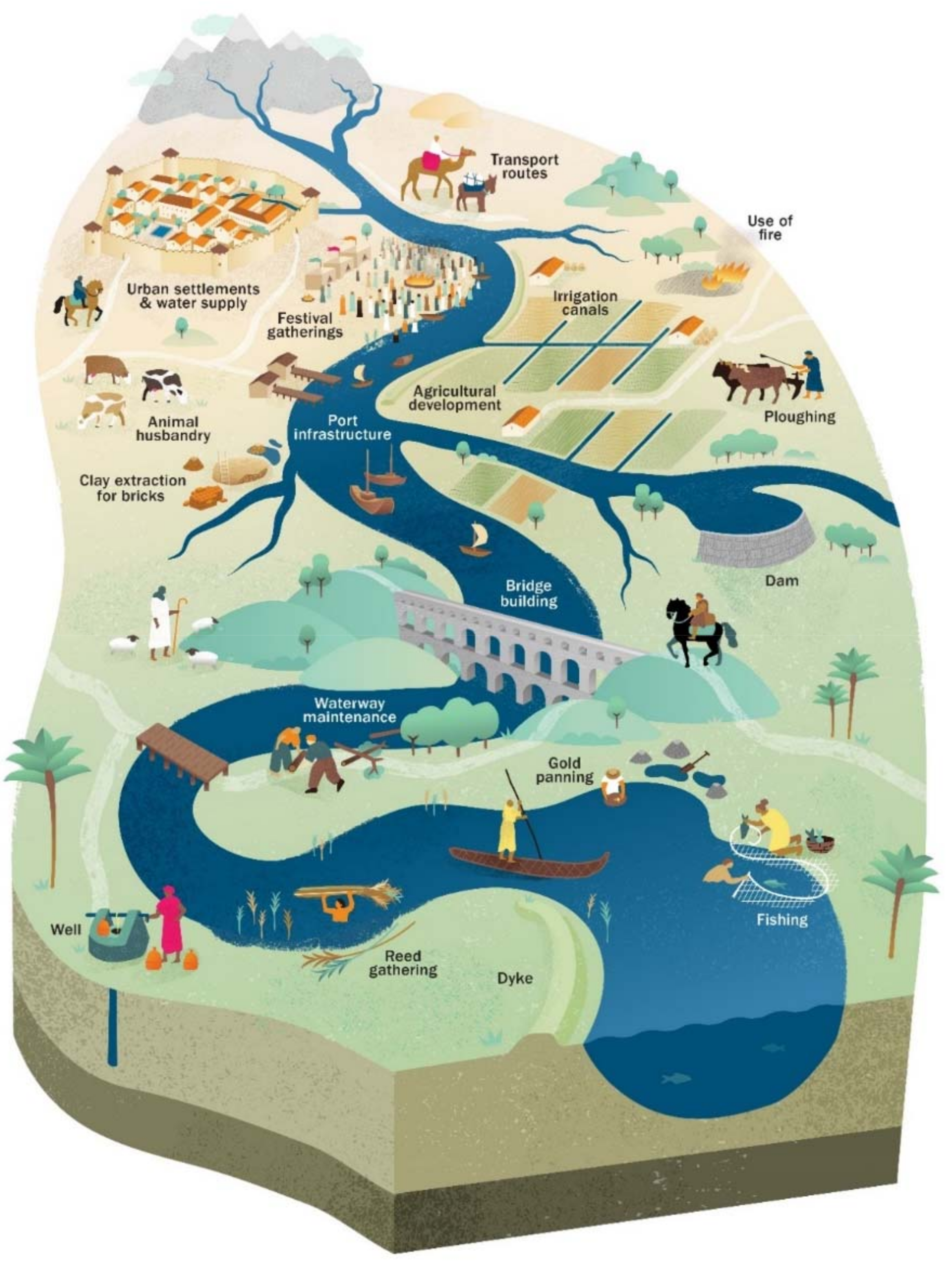
Figure 4.
Archaeological sites associated with rivers and springs. (A) Palaeolithic quartzite corestone extracted from cemented river gravels, Rajasthan, India. Coin 2.5 cm in diameter. (B) Palaeolithic to Mesolithic site above bedrock river bank in middle distance, Belan River, India [66]. The site had a small settlement where stone tools were worked. Stone extraction in progress in river bed. (C) Structure dated to ca. 10,300 to 9800 years ago at Jericho, Israel, possibly a watchtower for flash floods [67]. (D) Ancient well during dry season, near Sabarmati River, India. (E) Roman bath fed by hot springs, Bath, UK.

Figure 5.
Timeline and stages for the anthropogenic modification of river systems. See Table 2, Table 3, Table 4 and Table 5 for sources of the dates shown in the figure, with dates for early food processing [113,114] and intensification of cultivation and onset of domestication and agriculture [88]. Suggested stages in modification are based largely on information from the Near East, North Africa, Northwestern Indian Subcontinent, China, and parts of Europe. Note that the timing and intensity of anthropogenic influence vary greatly regionally [17,18]. Dates for Early, Middle, and Late Holocene (E, M, L) from [62].

Figure 6.
Comparison of stages in anthropogenic modification of rivers (Figure 5) with datasets for population and land use [8,9] and Yellow River sediment load [216]. Original graphs plotted in years before present.


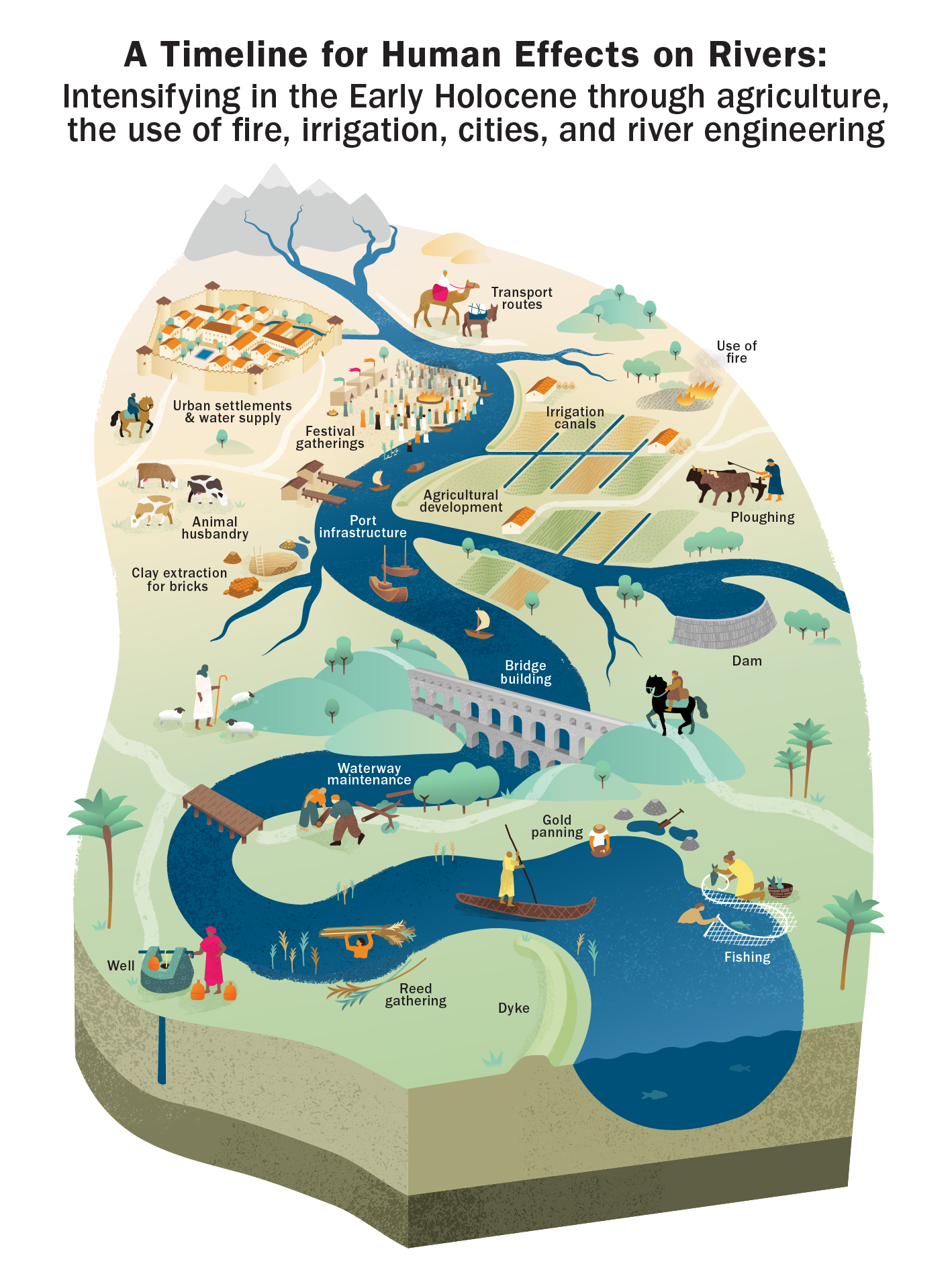
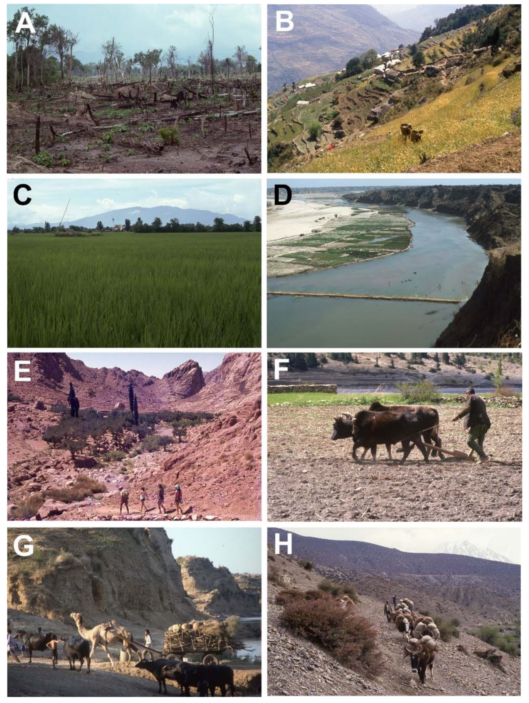
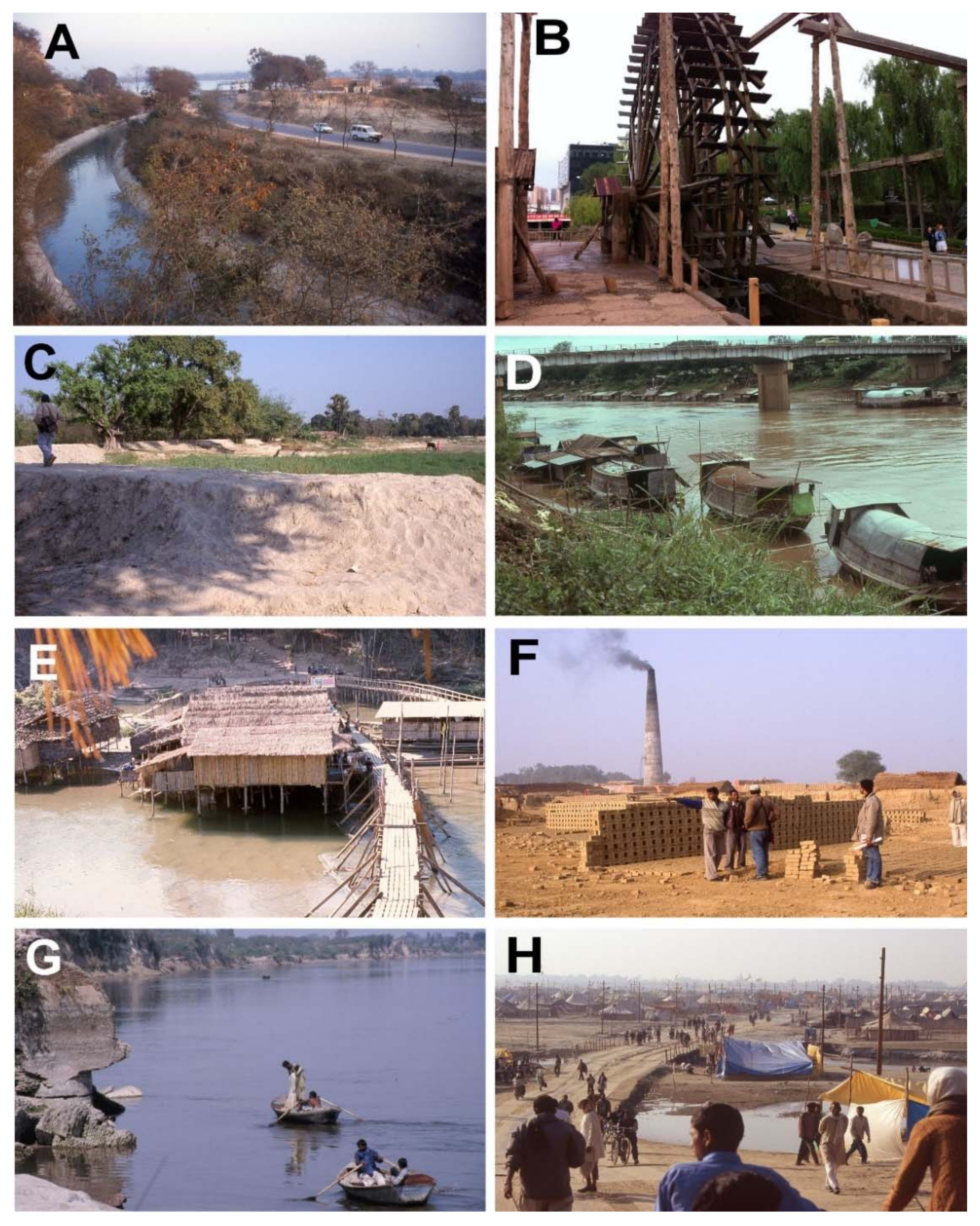
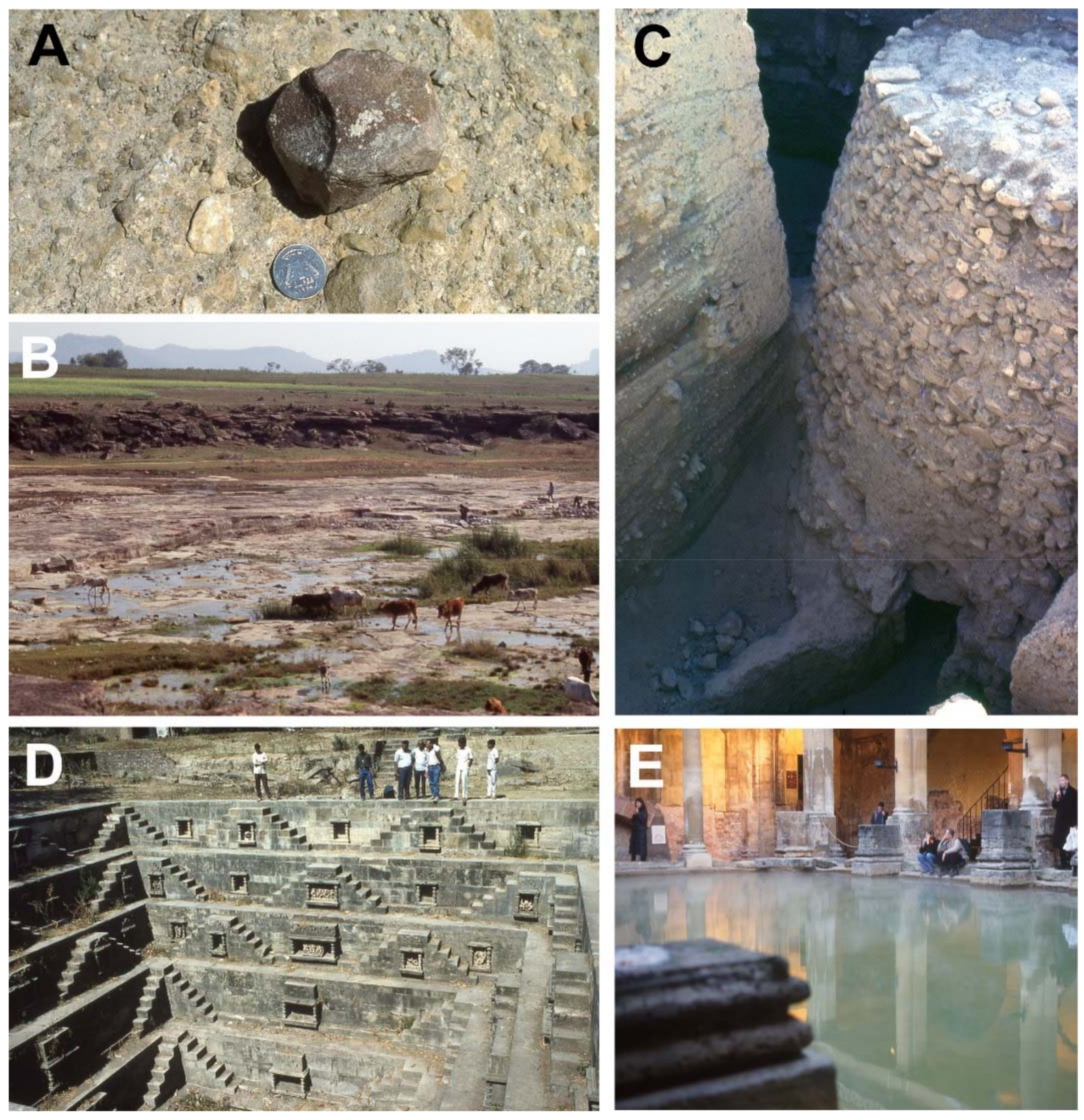
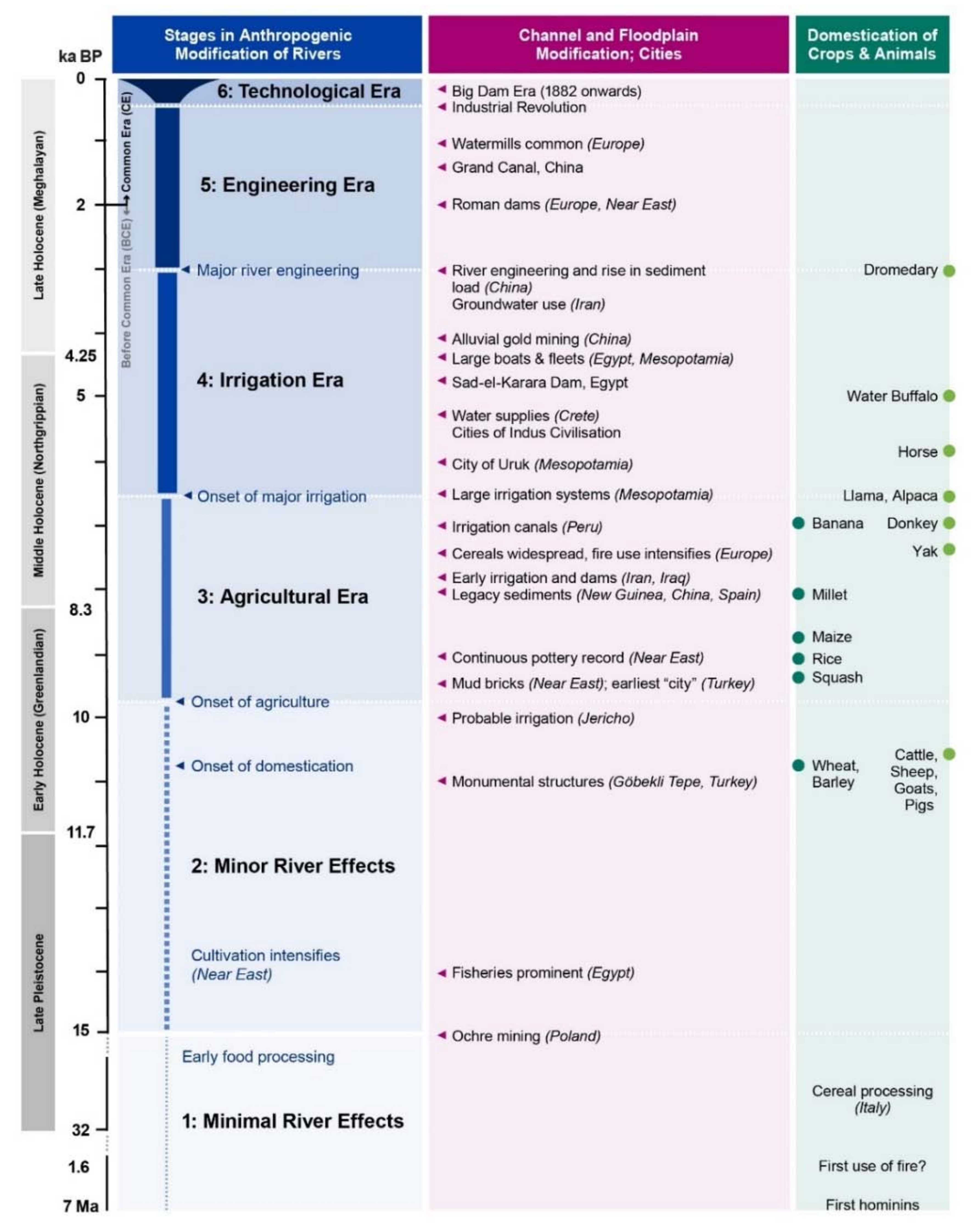
Table 1.
Effects of some anthropogenic activities on modern and submodern channel and floodplain systems. Some of the cited literature refers to human activity at a technological level much greater than that of the earlier Quaternary. Italics denote processes not substantiated here by citations.
Table 1.
Effects of some anthropogenic activities on modern and submodern channel and floodplain systems. Some of the cited literature refers to human activity at a technological level much greater than that of the earlier Quaternary. Italics denote processes not substantiated here by citations.
| Human Activity | Effects on Modern River Systems | References |
|---|---|---|
| Fire use | Vegetation loss promotes rapid runoff, soil erosion, and enhanced flux of sediment and charcoal to rivers. Change in soil properties enhances erosion. Fire may trigger vegetation change. | [28,29,30] |
| Agriculture and deforestation | Reduced resistance of river banks and hillslopes where crops with shallow roots replace natural vegetation. Widening of channels and sediment coarsening. Slope failure, and increased sediment flux to fluvial, deltaic, and eolian systems. Change in palynomorph associations. | [17,31,32,33] |
| Animals used for food, ploughing, and transport | Herds reduce vegetation cover and enhance soil erosion, gullying, and sediment flux to rivers. Trampling breaks down river banks, widens channels, and increases suspended load. Ploughing intensifies use of floodplains and hillslopes and, along with animal transport trails, enhances erosion. | [34,35,36,37,38,39,40] |
| Embankments along channels | Embankments narrow channels, reduce their migration, increase flow velocity, funnel sediment to deltas, and reduce channel siltation; complex upstream feedbacks. Sediment trapping within embanked floodplains reduces inundation capacity. Embankments raise the channel base, promoting catastrophic avulsion. | [41,42,43] |
| Dams and irrigation systems | Dams alter river flow regime, cause deposition in millponds and reservoirs, and increase downstream erosion. Irrigation reduces river discharge, and the use of river and groundwater promote soil waterlogging and salination. | [44,45,46,47] |
| Navigation and bank structures | Riverside construction (wharves, steps, access roads, bridges) affects banks and channels. Dredging, riverbed scour, and removal of wood snags and jams to aid navigation alters river morphology. Reduced number of delta distributary channels aids year-round navigation. | [48,49] |
| City water supplies | Remove river and groundwater from the hydrological system, with water pollution from sewage and waste. | [50] |
| Warfare | River diversions during warfare causes catastrophic floods and floodplain aggradation. Deliberate 1938 breach of the Yellow River dikes caused death toll of >800,000. | [51,52] |
| Extraction of channel and floodplain materials | Alluvial mining of channels and terraces for gold and other minerals increases aggradation and erosion rates locally. Pits on floodplains for bricks, tiles, pottery, and ochre, and on terraces for laterite remove fertile soil and aquifer media, cause soil erosion, increase suspended load, lower the water table, and cause waterlogging. | [43,53,54,55] |
| Extraction of aquatic materials | Reeds, papyrus and other in-channel plants influence flow dynamics and sedimentation. Fisheries and aquatic harvesting enhance human activity along river banks. | [56] |
| Cultural events | Water festivals involve large populations, with infrastructure on river banks and sand bars. Khumbha Mela festival at Allahabad, India, had 120 million attendees in 2 months in 2013. | [57] |
Table 2.
Estimates of time and place of domestication of some plants and animals. Evidence for domestication is based on a genetic selection process that leads to organisms adapted to cultivation and utilisation by humans [86]. See Section 3 for the approach used in presenting age dates. Dates shown are in calibrated years BP from the cited papers, with some general age assessments (*) and dates based on genetic analysis (**). cal: calibrated, uncal: uncalibrated.
| Crop or Animal | Data Sources | Approximate Date (years BP) | Location | References |
|---|---|---|---|---|
| Plant Domestication | ||||
| Barley, emmer, and einkorn wheat | Varied sources, cal | c. 12,000–10,000 | Near East | [87] |
| Approximate uncal date for domestic spikelets in einkorn wheat | 9250 | Near East | [85] | |
| Varied sources, cal | 10,700–10,200 | Near East | [88] | |
| Flax | Varied sources | 9000 | Near East | [89] |
| Date palm | Varied cal and uncal sources | >6000 | Arabia | [90] |
| Millet | Varied sources | 8000–7000 | China | [91] |
| Rice | Varied cal sources for initiation of rice cultivation | 9000 | China | [92] |
| Varied sources for domesticated rice, after 6000 cal BCE | 8000 | China | [84] | |
| Varied sources | 9000–8000 | China | [93] | |
| Squash | Cal date for charred or desiccated squash seed | 10,400–10,160 | Peru | [94] |
| Cal dates on plant and other materials | >8700 | Mexico | [95] | |
| Maize | Cal dates on plant and other materials | >8700 | Mexico | [95] |
| Peanut | Cal dates for charred peanut hull | 8640–8440 | Peru | [94] |
| Cotton | Cal dates for cotton boll | 6280–5950 | Peru | [94] |
| Banana | Cal dates on materials that include banana phytoliths | 6950–6440 | New Guinea | [96] |
| Grape and wine culture | Cal dates on pottery sherds, ca. 7000–6600 BCE | 9000 | China | [97] |
| Cal dates on pottery sherds and soil, ca. 5900–5750 BCE | 8000 | Georgia | [98] | |
| Animal Domestication | ||||
| Cattle | Varied sources, cal date for Early Pre-Pottery Neolithic site, Syria | 10,650–10,250 | Near East | [99] |
| Sheep, goats | Cal dates for Early Pre-Pottery Neolithic at Near East sites | 10,250–9500 | Near East | [100,101] |
| Pigs | Intensification of relationship between humans and pigs, second half of 9th millennium BCE, sites in Turkey and Cyprus | >10,000 | Near East | [102] |
| Assessment of zooarcheological data | 9000 | Near and Far East | [103] | |
| Water buffalo | Varied sources suggest 3rd to 5th millennium BCE in parts of Asia and Near East; authors support origin in Indian Subcontinent | 5000 | Indian Subcontinent | [104] * |
| Horses | Faunal remains, bridles and milk suggest mid-4th millennium BCE, using cal dates | 6000–5000 | Eurasian steppes | [105,106] * |
| Dromedary | Varied archeological sources suggest late 2nd millennium BCE | >3000 | Arabia | [107] * |
| Donkey | Varied archeological sources suggest late 5th to first half of 4th millennium BCE in Egypt | 7000–6000 | Africa | [108,109] * |
| Yak | Genome model for domestication, confidence interval of 7914 to 7227 BP | 7300 | Tibetan Plateau | [110] ** |
| Llama, Alpaca | Archaeozoological data at dated sites and genome models | 7000–6000 | Peruvian Andes | [111] *, [112] ** |
Table 3.
Some early events in the development of water technology and river navigation. See Section 3 for the approach used in presenting age dates. Dates in original papers are based on assessments of archaeological evidence and historical events, with a few dates in calibrated years BP (*). cal: calibrated.
| Location | Activity | Approximate Date (Years BP) | References |
|---|---|---|---|
| Irrigation and Drainage Systems | |||
| Mesopotamia and uplands | Irrigation systems in existence in SW Iran by 5000 BCE, maybe by 6000 BCE, with large organised systems on Mesopotamian plains by 4500 BCE | ~8000–7000 | [129,135] |
| Near East | Water raising systems: shaduf (well sweep) by 2300 BCE, with later appearance of saqia (water wheel) and Archimedes screw in Ptolemaic times | ~4300 | [133] |
| New Guinea | Drainage ditches and channels, from cal dates on charcoal in ditch fills | 4350–3980 | [96] * |
| China | Large-scale engineering of embankments and canals on Yellow River for flood control and irrigation, with large dike projects in first half of 7th century BCE [144] to the 1800s | ~3000 | [41,144,145] |
| Peru | Irrigation canals dated at 5000 to 3750 cal BCE | ~7000 | [146] |
| U.S.A. | Gila River, Arizona: large areas under irrigation by 900 BCE, and earth dam 5 km long and 7 m high with irrigation canals by 1000 CE [147]; individual irrigation systems of 10,000 hectares (100 km2), with large developments in 850–1450 CE [148]; distinction of canals from natural channels [136] | ~2900 | [136,147,148] |
| Dams | |||
| Near East | Weirs of brushwood, stones and earth divert water into irrigation canals [135], estimated at 8000 years ago on E flank of Mesopotamia [149] | ~8000 | [135,149] |
| Mesopotamia | Nimrud Dam, probably an earth dam, diverted Tigris; dam later failed and returned the Tigris to its former course | >4000 | [133,150] |
| Egypt | Sadd-el-Kafara Dam (Dam of the Pagans), 14 m high, >100 m long, with 17,000 cut stone blocks; built to aid quarrying ca. 2650 BCE | 4650 | [133] |
| Near East and Europe | 45 dams built under the Roman Empire in the Near East, with irrigation canals, waterwheels, aqueducts, and qanat systems, from 63 BCE to 636 CE [151]. Earthen dams in Spain: Prosperina 12 m high and 427 m long, Cornalvo 20 m high and 194 m long with dam crest 8 m wide [133]. | 2700–1400 | [133,151] |
| China | Dam at Anfeng Tan, east China, ca. 600 BCE | 2600 | [152] |
| Groundwater Systems | |||
| Iran | Qanat systems of sloping tunnels that bring water from water table or springs at a high elevation to fields downslope, dated to ca. 3000 years ago in Iran, introduced from Indus to Nile under Persian rule, 550–331 BCE | ~3000 | [133] |
| Israel | Chamber excavated at Hazor, where water rises up the Dead Sea Fault; access to the underground water table by staircases; construction coeval with stratum dated at 9th century BCE | 2800 | [153] |
| Israel | Tunnel at Siloam, Jerusalem, routes spring within walls, dated by U-Th dating of speleothems, cal radiocarbon dating, and historically to ca. 700 BCE | 2700 | [154] |
| River Navigation | |||
| Egypt | Models of reed and log rafts at ca. 5500 to 4000 BCE [155]. Boats preserved to >5000 years ago, with a wooden boat 43.6 m long preserved from 4th dynasty, ~2500 BCE; barge with two 350-ton obelisks towed by 27 boats with 810 oarsmen, ca. 1472 to 1458 BCE [156]. | >7500 | [155,156] |
| Mesopotamia | Fleets for transport and warfare on Tigris, Euphrates, and canals; request for 600 vessels to bring grain to Ur in 3rd Dynasty [156]; channel straightening for boats, 3rd to 1st millennium BCE [135]. | ~4000 | [135,156] |
| China | Grand Canal, 1800 km long, linked pre-existing canals, rivers, and lakes; connected southern and northern plains, locks across Yellow River; built by 5 million workers | 609 CE | [157] |
Table 4.
Estimates of time and place of early use of channel, floodplain and aquatic resources, and the development of large settlements on floodplains. See Section 3 for the approach used in presenting age dates. Most dates are based on assessments of archaeological evidence and historical events. Some dates (*) are based on calibrated (cal) dates, uncalibrated (uncal) dates, OSL, and TL dates.
| Activity and Location | Approximate Date (Years BP) | References | |
|---|---|---|---|
| Large settlements and cities | |||
| Mesopotamia, Uruk period ca. 4000–3000 BCE (uncal) [166]; area of 400 ha by Early Dynastic II period, ca. 2700 BCE [167] | >6000 | [166,167] | |
| Indus Civilisation, first cities in the region before 3500 BCE; >500 ha of large settlements in aggregate by late Mature phase; peak populations of 40,000 in Harappa and Mohenjodaro, and several million inhabitants in the region in the Mature phase | 5500 | [168] | |
| Egypt, city of Memphis in Early Dynastic and Old Kingdom times, ca. 3000 to 2165 BCE | 5000 | [167] | |
| China, Longshan times, ca. 2600 to 2000 BCE; Anyang covered 15 km2 along 6 km of the Yellow River by 1200 BCE | 4600 | [167] | |
| Mesoamerican cities, lowland Maya cities from 900 to 300 BCE | 2900 | [167] | |
| Urban water systems | |||
| Indian Subcontinent | Indus Civilisation, with early urban phase ca. 2800 to 2600 BCE [167,169]; extensive public and private systems: wells, baths, street drains, and sewage pits during 3rd millennium BCE [133]. | ~4800 | [133,167,169] |
| Crete | Minoan culture, with wells, cisterns, fountains, and aqueducts from rivers and springs, in Early Minoan period ca. 3500 to 2150 BCE | 5500–4150 | [133] |
| Resources from channel and floodplain sediments | |||
| Alluvial gold | Working of placer deposits in rivers in China (Xia, Shang, and Zhou dynasties, ca. 2100 to 256 BCE), with advances in dredging and hydraulic methods | 4100 | [170] |
| Mud bricks (sun dried) | Earliest known bricks at Jericho ca. 7500 BCE, with later Indus cultural examples in Baluchistan ca. 7000 BCE | ~ 9500 | [168] |
| Structures preserved in Egypt with bricks of Nile mud and straw; buildings with reed layers, ca. 3050 to 2687 BCE | ~5050--4690 | [171] | |
| Baked bricks | Indus Civilisation, widely used in Mature Phase from 2800 BCE | 4800 | [168] |
| Earliest pottery | China, with other Late Pleistocene occurrences in Asia, based on calibrated dates on associated bone and charcoal [172] and assessment of dates from varied calibrated sources [173] | ~ 20,000 | [172,173] * |
| Continuous pottery record | At sites in Mesopotamia and Anatolia, with initial pottery levels dated to ca. 7000 BCE | ~ 9000 on | [174] |
| Earliest pottery | At sites along the Amazon in Brazil, based on cal dates and a TL date | 8000–7000 | [175] * |
| Ochre | Poland, excavation of 25 acres of red floodplain clay to >1 m depth; occupied from ca. 15,500 to 11,500 years ago [176] | 15,500 | [176,177] |
| Aquatic resources | |||
| Reeds | Large reed buildings in Uruk period of Mesopotamia, >5000 years ago [178]; reeds used in Egyptian tombs of Old Kingdom, ca. 2686 to 2160 BCE [179] | >5000 | [178,179] |
| Papyrus | Used in Egypt since at least 3000 BCE, with large-scale production probably controlled by the state; Greco-Roman factories in the Nile Delta [180]. Oldest inscribed at Wadi al-Jarf with hundreds of fragments from reign of Khufu (2589–2566 BCE) [181] | >5000, ~ 4570 | [180,181] |
| Fish and other aquatic organisms | Known from Middle Palaeolithic sites on the Nile. Prominent Nile fisheries from > ca. 14,000 years ago, with salting for storage from ca. 9000 years ago; along Amazon in Brazil from ca. 11,200 years ago, Yangtze in China from ca. 10,000 years ago, and Columbia in USA from ca. 9300 years ago. Sites include molluscs, turtles, and amphibians. Based on cal and uncal dates and OSL dates [182], cal dates [183], dates from varied sources with calibration not reported [184], and calibrated dates [185] | >14,000 | [182] *, [183] *, [184] *, [185] *, [186], [187] |
Table 5.
Some examples of anthropogenic sediment and effects in river systems. Middle and Late Holocene dates are in calibrated years BP, and dates for the past millennium are based on historical evidence.
Table 5.
Some examples of anthropogenic sediment and effects in river systems. Middle and Late Holocene dates are in calibrated years BP, and dates for the past millennium are based on historical evidence.
| Location | Legacy Sediments | References |
|---|---|---|
| Middle Holocene to Early Late Holocene | ||
| New Guinea | From 7800 cal yr BP on, clearance of forest, expansion of herbaceous vegetation, and increased charcoal from use of fire. Aggradation in Baliem River valley. Banana and other crops in an anthropogenic landscape by 6950 to 6440 cal yr BP. Drainage ditches and channels dated at ~4350–3980 cal yr BP. Based on calibrated dates. | [81,96] |
| China | Agriculture and population growth after ~7700 cal yr BP in Yellow River system, based on charcoal, pollen and sediment records, with onset of slash-and-burn [213]. Widespread effects by 7000 cal yr BP [214]. Valley alluviation and hillslope erosion from ~5300/5010 BCE through 2130/1870 BCE, in Yiluo River system; pottery, bones, charcoal, and fossil evidence for rice farming [122]. Deforestation of Loess Plateau increased Yellow River sediment load at ~ 3000 cal yr BP [216]. Based on OSL and cal dates. | [122,213,214,216] |
| Spain | Aggradation and incision episodes in the Ebro Basin, with valley-floor sedimentation from ~ 8000 cal yr BP (6000 BCE), intensifying during the Bronze and Iron Ages and through the Roman period. Associated charcoal and pottery. Based on cal dates and artefacts. | [205] |
| UK | Clays dated at 4440–3560 cal yr BP, during change from woodland to scrubland with cereal crops. Overlying silty sand at ~ 4100 cal yr BP in Frome River system. Linked to deforestation and expanded arable farming, with increased sedimentation rate. Based on cal and OSL dates. | [17] |
| Italy | Original vegetation lost by Bronze Age ~ 3300 cal yr BP in Po River plain. Drainage ditches and irrigation channels since Early Iron Age. Widespread Roman deforestation, intensification of farming, roads and ditches after ~ 2100 cal yr BP. River courses embanked and prevented from silting. Soil erosion caused Po delta to prograde further at ca. 300 CE than in previous centuries. Based on cal dates. | [217,218] |
| Mexico | Agriculture and deforestation enhanced erosion by 3450 cal yr BP, intensifying with urban development after 2350 cal yr BP. Río Verde shows increased sediment load, aggradation, and change from meandering to braided. Spread of overbank fines expanded agricultural areas. Coastal morphology modified. Based on cal dates. | [219] |
| Past Millennium | ||
| NW Europe | Salmon stocks declined by 90% from Early Middle Ages (~ 450–900 CE) to ~1600 CE. Decline matches watermill expansion; weirs and millponds blocked access to upstream spawning grounds. River gravel covered with silt and mill waste. | [220] |
| USA | Buildup of slackwater sediment from ~1700 CE, behind tens of thousands of 17–19th century milldams in northeastern rivers. Underlying soils and gravel represent forested wetlands with anabranching channels, now mainly lost. | [204] |
| China | After ~1800 CE in SW China, intense cultivation and population pressure caused soil erosion and hillslope collapse. Fluvial aggradation of 2 m/yr, channel blockages. | [221] |
| U.S.A. | Release of 1.3 billion m3 from hydraulic gold mining in Sacramento River system, California after 1849 gold rush. Aggradation of 60 m of alluvium, followed in a few decades by incision. Rapid sedimentation of San Francisco Bay. | [53] |
| Global | Currently >50,000 large dams >15 m high. 17 million dammed reservoirs of all sizes, with a volume >8000 km3. Severe effects on sediment transport, flow regimes, and biodiversity of freshwater ecosystems. | [20,222] |
| Global | Rivers swept by waves of millions of cubic metres of toxic waste and cyanide from mine-dam failures and pipeline breaks. | [223,224] |
| China | South-North Diversion Project, with capacity to deliver 25 billion m3 from Yangtze to northern China along two routes, each >1000 km long. Partially constructed. | [152] |
© 2018 by the author. Licensee MDPI, Basel, Switzerland. This article is an open access article distributed under the terms and conditions of the Creative Commons Attribution (CC BY) license (http://creativecommons.org/licenses/by/4.0/).
Share and Cite
MDPI and ACS Style
Gibling, M.R. River Systems and the Anthropocene: A Late Pleistocene and Holocene Timeline for Human Influence. Quaternary 2018, 1, 21. https://0-doi-org.brum.beds.ac.uk/10.3390/quat1030021
AMA Style
Gibling MR. River Systems and the Anthropocene: A Late Pleistocene and Holocene Timeline for Human Influence. Quaternary. 2018; 1(3):21. https://0-doi-org.brum.beds.ac.uk/10.3390/quat1030021
Chicago/Turabian StyleGibling, Martin R. 2018. "River Systems and the Anthropocene: A Late Pleistocene and Holocene Timeline for Human Influence" Quaternary 1, no. 3: 21. https://0-doi-org.brum.beds.ac.uk/10.3390/quat1030021