Article

The Toledo Mountains: A Resilient Landscape and a Landscape for Resilience? Hazards and Strategies in a Mid-Elevation Mountain Region in Central Spain

by
Reyes Luelmo-Lautenschlaeger
1,2,*,
Sebastián Pérez-Díaz
3,
Olivier Blarquez
4,
César Morales-Molino
5 and
José Antonio López-Sáez
1
1
Instituto de Historia, CSIC, C/Albasanz 26-28, 28037 Madrid, Spain
2
Departamento de Geografía, Universidad Autónoma de Madrid, C/ Francisco Tomás y Valiente 1, 28049 Madrid, Spain
3
Departamento de Geografía, Urbanismo y Ordenación del Territorio, Universidad de Cantabria, Avenida Los Castros 44, 39005 Santander, Spain
4
Département de Géographie, Université de Montréal, Pavillon 520, Chemin Côte Sainte-Catherine, C.P. 6128, Succursale Centre-ville, Montréal, QC H3C 3J7, Canada
5
Institute of Plant Sciences and Oeschger Centre for Climate Change Research, University of Bern, Altenbergrain 21, 3013 Bern, Switzerland
*
Author to whom correspondence should be addressed.
Submission received: 30 June 2019 / Revised: 8 October 2019 / Accepted: 10 October 2019 / Published: 18 October 2019

Abstract

:
The Toledo Mountains are a mid-elevation mountain range that separates the Tagus and Guadiana basins in the central area of the Iberian Peninsula. The location of these mountains allows the development of typical Mediterranean vegetation with some Atlantic influence. Consequently, typical broadleaved evergreen Mediterranean vegetation currently dominates the regional landscape, with the remarkable presence of more mesophilous species in sheltered and more humid microsites such as gorges (e.g., Prunus lusitanica, Taxus baccata, Ilex aquifolium) and mires/bogs (e.g., Betula pendula susbp. fontqueri, Erica tetralix, Myrica gale). Palaeoecological studies in these mountains are essential to understand the long-term ecology and original distribution of these valuable communities and are key to assess their resilience. Understanding the hazards and opportunities faced in the past by the plant communities of the Toledo Mountains is necessary to enhance the management and protection of those species currently threatened. This study focuses on El Perro mire, a peatland on the southern Toledo Mountains (central Spain) where climatic variability has played a major role in landscape dynamics at multi-decadal to millennial timescales. Climatic events such as the 4.2 ka cal. Before Present (BP) or the Little Ice Age triggered relevant landscape changes such as the spread and latter decline of birch and hazel forests. Human communities also seemed to be affected by these events, as their resilience was apparently jeopardized by the new climatic conditions and they were forced to find new strategies to cope with the new scenarios.

1. Introduction

The Mediterranean Basin is one of the most important biodiversity hotspots worldwide, characterized by a large number of endemic species [1,2]. Although marked seasonality and dry summers are distinctive features of the Mediterranean climate, climate model projections predict notably warmer and drier climatic conditions in the Mediterranean region, particularly in its western sector [1,3]. Additionally, extreme climatic events such as droughts and floods are very common in the Mediterranean Basin, with a strong influence on Mediterranean vegetation dynamics and human culture development over time [4,5,6,7]. Both have been driven not only by the above-mentioned climatic conditions, but also by other features linked to the particular geographical framework, such as the rugged topography or the shallow soil [8].
Additionally, there is ample evidence that fire has been a major disturbance in the Mediterranean region, particularly during the mid and late Holocene [4,8,9,10,11]. Fire has notably determined the distribution, structure and composition of the vegetation, and landscapes capable of withstanding frequent fire episodes are widespread in the Mediterranean Basin [12]. In this environment, it is important to note that fire can be sparked by natural causes or human-induced. Consequently, for those ecosystems where fire is just an integrated ecological factor and provides many services [13], the real disruption are changes in the fire regime (severity, frequency, etc.) [14,15]. During the mid and late Holocene, and in particular since the Bronze Age, fire has been ruled by human-related activities [4,8,16]. The different cultures that have inhabited the Mediterranean region have had a deep impact in the landscape, with fire used to clear forests to create and maintain pastures, expand crops and exploit forest resources [4,17].
Hence, due to this ecological and cultural background, Mediterranean landscapes consist of diverse vegetation mosaics rich in species and including different successional stages. A number of threatened species find refuge in this vegetation patchwork, especially in the mountainous terrain, thus reinforcing the key role of these systems in protecting the biodiversity at the whole basin scale [18,19,20,21]. The Toledo Mountains are a mid-elevation mountain area located in the heart of the Iberian Peninsula whose landscape dynamics are closely related to human history. This system is a perfect scenario to conduct palaeoecological studies because mountainous regions are especially sensitive to climatic changes. Furthermore, mid-elevation mountain systems have usually involved human activities, so it will be possible to determine the pace at which cultural landscapes have been created and the role played by each agent throughout their history [22,23]. Previous research in these mountains has highlighted this human resource management and the influence of climate in shaping their landscape [24,25,26,27,28,29,30].
This paper aims to study the landscape dynamics in the southernmost area of the Toledo Mountains and assess the importance of two of its drivers: climatic variability and human influence. Palaeoecological studies are the best way to understand the evolution of vegetation and the resilient processes faced not only by vegetation communities, but also by human settlers, and are essential to provide tools for coherent forest management and conservation or restoration policies [31,32].

2. Materials and Methods

2.1. Study Area

The Toledo Mountains consist of low mountain ranges located between the Toledo and Ciudad Real provinces, in the central part of the Iberian Peninsula (Figure 1). They were originated during the Hercinian orogeny and totally eroded over time. Mainly composed of quartzite and slate bedrock with rare granitic outcrops, the mean elevation of these mountainous lands range between 600–800 m above sea level (m a.s.l.), with their highest peak reaching 1447 m a.s.l. (Rocigalgo Massif, Los Navalucillos municipality) [33,34]. At lower altitudes, in the deep spaces left in the harsh valleys, the eroded materials laid down the slopes and build up structures locally called “rañas” at the bottom of the slopes. The result is a region of gentle ranges with rounded shapes but intricate morphology as long as they combine the elevations with the deep valleys. The Toledo Mountains extend east–west through the western side of the Southern Iberian Plateau, separating the Tagus and Guadiana basins and bordering the La Mancha plain to the east [33].
The climate is typically Mediterranean, with dry and warm summers and cold and wet winters. There is a notable oceanic influence at the western edge of the massif linked to the humid winds coming from the Atlantic Ocean. The average temperature is 17 °C and the mean annual rainfall recorded oscillates between 600–800 mm [22,34,35]. The vegetation on the Toledo Mountains meso-Mediterranean foothills is mainly composed of holm oak (Quercus ilex sub. ballota) and cork oak (Q. suber) woodlands. Holm oak communities include meso-thermophilous taxa like Arbutus unedo, Phillyrea angustifolia, Pistacia terebinthus and Pyrus bourgaeana. Cork oak forests are mainly associated with deciduous trees like Quercus faginea subsp. broteroi, Q. pyrenaica and Acer monspessulanum. Quercus pyrenaica dominates above 900 m a.s.l. in the supra-Mediterranean bioclimatic belt. On the other hand, the Toledo Mountains host a number of relict temperate, Atlantic and even Tertiary species such as Myrica gale, Corylus avellana (hazel), Prunus lusitanica, Betula pendula or B. pubescens (birch) [22,23,28,29,30,36]. These taxa are rare but it is still possible to find hazel populations or Betula stands over most of the area. Most of them are sheltered in the most inaccessible locations and protected by law.
El Perro (39°3’46.56” N; 4°45’34.60” W; 690 m a.s.l.) is a minerotrophic mire located at the foothills of the Cerro del Trampal del Pero (838 m a.s.l.) on the eastern end of the Sierra de Dos Hermanas range, where it joins the Sierra de los Bueyes range (Ciudad Real province; Figure 1), under the mountain pass of Puerto de Salsipuedes. The mire is located at the contact between the hillslope and the “raña”, probably related to subsurface runoff discharge. In the surroundings of the mire, the vegetation is mainly composed of Erica tetralix¸ Dactylorhiza elata subsp. sesquipedalis, Drosera rotundifolia, Lobelia urens, and Sphagnum capillifolium, among others.
In the past, the mire could have extended over a surface of approximately 315.6 ha instead of the current 3.74 ha [22]. The mire would have largely retreated due to long-lasting landscape management. In fact, El Perro mire is currently threatened by drainage, erosion, overgrazing, ungulate and wild animal pressure, and agricultural exploitation, including drying and agrochemicals. Human disturbance is also very present in the road trespassing and crossing the mire surface and in the dumping in some areas. This is not a protected mire, despite being inside a currently fenced private property, although this protection is only affecting the last active area of this mire, without any chance of recovery for the rest of it.

2.2. Sampling and Chronology

A 100 cm long peat core was collected using a Russian peat corer (50 cm long and 5 cm in diameter). Peat sections were placed in PVC (polyvinyl chloride) tubes and properly stored under dark and cold conditions (4 °C). The core was sub sampled into contiguous 1 cm thick portions. Ten bulk peat samples were 14C dated at the radiocarbon laboratories of Poznán (Poznán, Poland) and Angstrom Laboratory of Uppsala University (Sweden) using the Acelerator mass spectrometry (AMS) technique (Table 1). The dates were calibrated using CALIB 7.1 with the IntCal13 curve [37]. Samples younger than 1950 were treated according to Hua and Barbetti [38]. An age-depth model was produced using the R package “clam” running in R.3.2.2 [39,40]. The best fit was obtained applying a smoothing spline to the available radiocarbon dates (Figure 2). Confidence intervals of the calibrations and the age-depth model were calculated at 95% (2σ) with 1000 iterations.

2.3. Pollen Analysis

Pollen analysis was carried out on 40 sub-samples of 1 cm3 separated by 2 cm. The topmost 20 cm were treated as one single sample due to their extremely herbaceous nature and the risk of handling them as smaller subsamples. All samples were treated chemically following standard procedures. HCl was used for removing carbonates, while KOH was used to remove the organic matter. HF was finally used to remove silicates [41]. Thoulet solution was used for the densimetric extraction of microfossils contained in the peat [42]. Acetolysis was not carried out to allow the easy identification of any contamination by modern pollen. Macrofossils were not discerned throughout the core. Pollen concentration (grains cm−3) was estimated by adding a Lycopodium tablet to each sample [43]. Terrestrial pollen counts were always over 500 grains per sample. Pollen of aquatic, wetland plants and the mire shrubs Erica tetralix and Myrica gale, as well as spores and non-pollen palynomorphs (NPPs), were excluded from the terrestrial pollen sum.
Palynomorphs were identified based on the reference collection at the Centro de Ciencias Humanas y Sociales del Consejo Superior de Investigaciones Científicas in Madrid, and diverse identification keys and photo atlases [41,44,45,46,47,48]. Betula, Myrica and Corylus pollen types were identified following [44,49], and Erica pollen types according to [50]. Pollen diagrams have been plotted against depth and against age using TGview [51]. For the zonation of the pollen sequence, we tested several divisive and agglomerative methods with the program IBM SPSS Statistics 21. Considering the ecological meaning of the obtained zones, local pollen assemblage zones were eventually delimited using agglomerative constrained cluster analysis of incremental sum of squares (CONISS) with square-root transformed percentage data [52]. The number of statistically significant zones was determined using the broken-stick model [53].

2.4. Charcoal Analysis

Fire reconstructions of peat sequences are based on charcoal accumulation in the peatland during and shortly after the relevant fire event [54]. To reconstruct fire history, we took contiguous 1 cm thick peat samples of 1 cm3 each centimeter throughout the core according to the recommendations provided by Whitlock and Larsen [55]. Charcoal samples were soaked in a 10% KOH solution for 24 h and then in 15% H2O2 for 24 h more in order to remove and bleach uncharred organic matter. The sediment was then sieved using a 125 µm light mesh and the number of charcoal particles in each sample was counted under the stereomicroscope. Macroscopic charcoal particles mostly have a local to extra-local origin (<10 km) [54,55,56,57,58].
Peak detection analysis (Figure 5) was performed with MATLab and RStudio using the R package Paleofire [59]. Prior to the analysis of charcoal records, the macroscopic charcoal sequence was interpolated to a constant time resolution, in this case the median deposition time (XX yr), to reduce biases resulting from changes in sediment accumulation rate and produce a stationary series with comparable fire peaks [60]. Charcoal accumulation rate (CHAR) distributions are composed of two components, Cback and Cpeak. Cback corresponds to the slowly varying background component, showing the regional trend; meanwhile the Cpeak component is related to local fire events [61]. All five possible smooth methods available within CharAnalysis [62] have been applied to find the Cback using smoothing windows ranging from 100 to 1500 years such as t = 100, 125, 150, 175, 200, …, 1500. In total for each site, we obtained 5 × 55 = 275 reconstructions. Cpeak has been obtained by subtracting Cback to interpolated CHAR (Ci–Cback). Cnoise is the statistical noise produced in the analysis and some Cback values included in the Cpeak distribution. Cfire corresponds to the fire events and they could reveal one great event or the cumulative effect of many events. Cfire values exceeding the above-mentioned threshold are interpreted as fire events [19,60,61,63]. The signal to noise index (SNI) was calculated to assess the accuracy of the models obtained [8,60,64].

2.5. Magnetic Susceptibility

Before sub-sampling the cores, magnetic susceptibility analysis was carried out every 1 cm (Figure 6). Magnetic susceptibility (MS) is a measure which indicates the magnetic minerals accumulated in the sediment. These mineral sediments could be related to erosive events, which can be of natural origin or otherwise caused by human activities [65]. It is also a useful proxy for fire occurrence [66] in combination with peak detection analysis. In this case, we analyzed the cores with a Bartington sensor MS2E (Bartingon instruments, Ltd, Witney, UK) following standard procedures [67].

3. Results

3.1. Lithostratigraphy and Chronology

The profile consists of uniform dark brown to black peat, except for the basal 5 cm corresponding to fine sands, where MS values are highest (Figure 6). According to the age-depth model, peat accumulation started at approximately 5200 cal. BP at El Perro mire (Figure 2). We considered the 99 cm sample (Poz-84257) as an outlier (too old) because of the presence of reworked organic carbon in the fine sands at the bottom of the sequence (Table 1). Peat deposition was exceptionally slow between 60 and 50 cm deep, but there is no indication in the lithology suggesting the occurrence of hiatuses here.

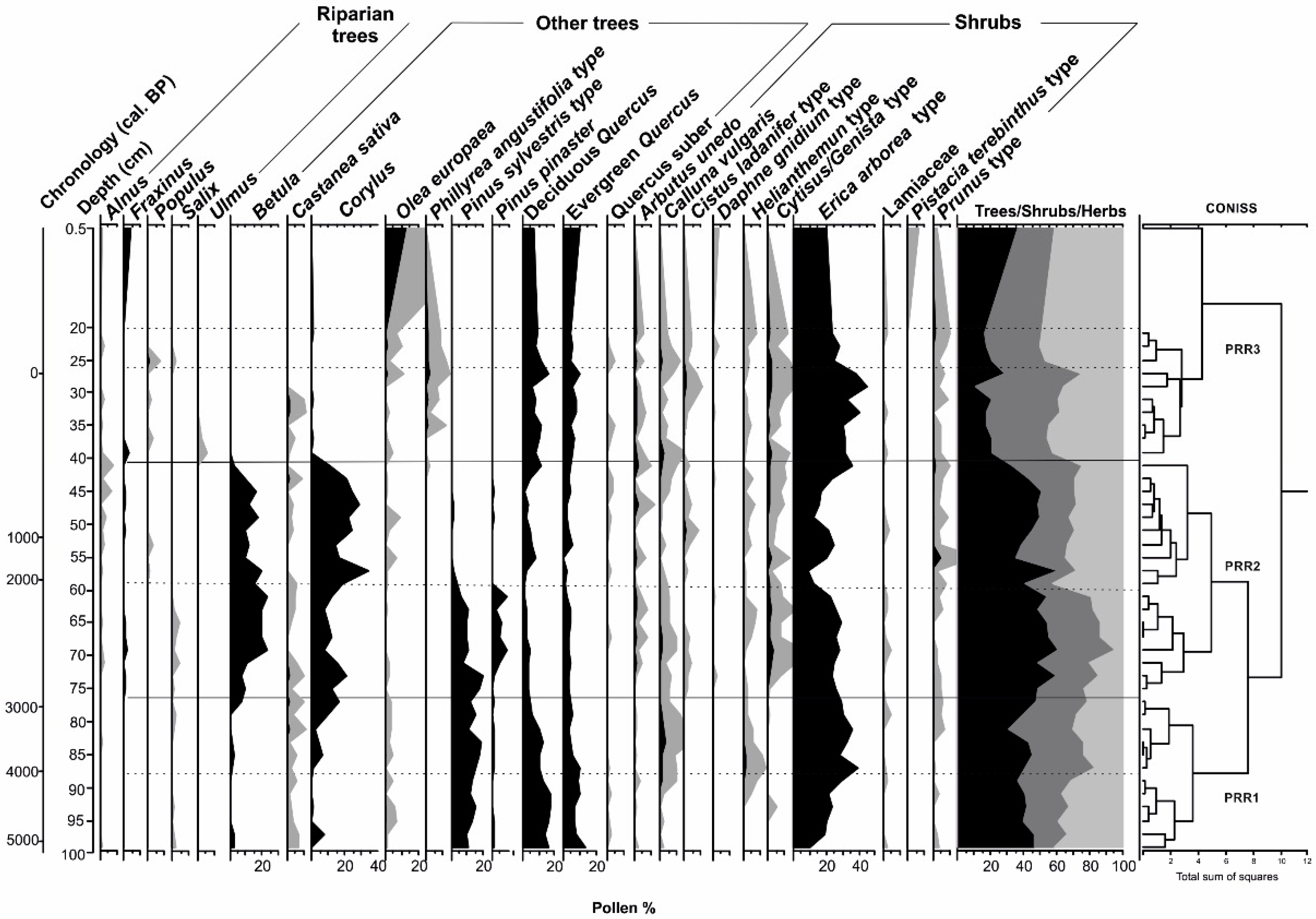
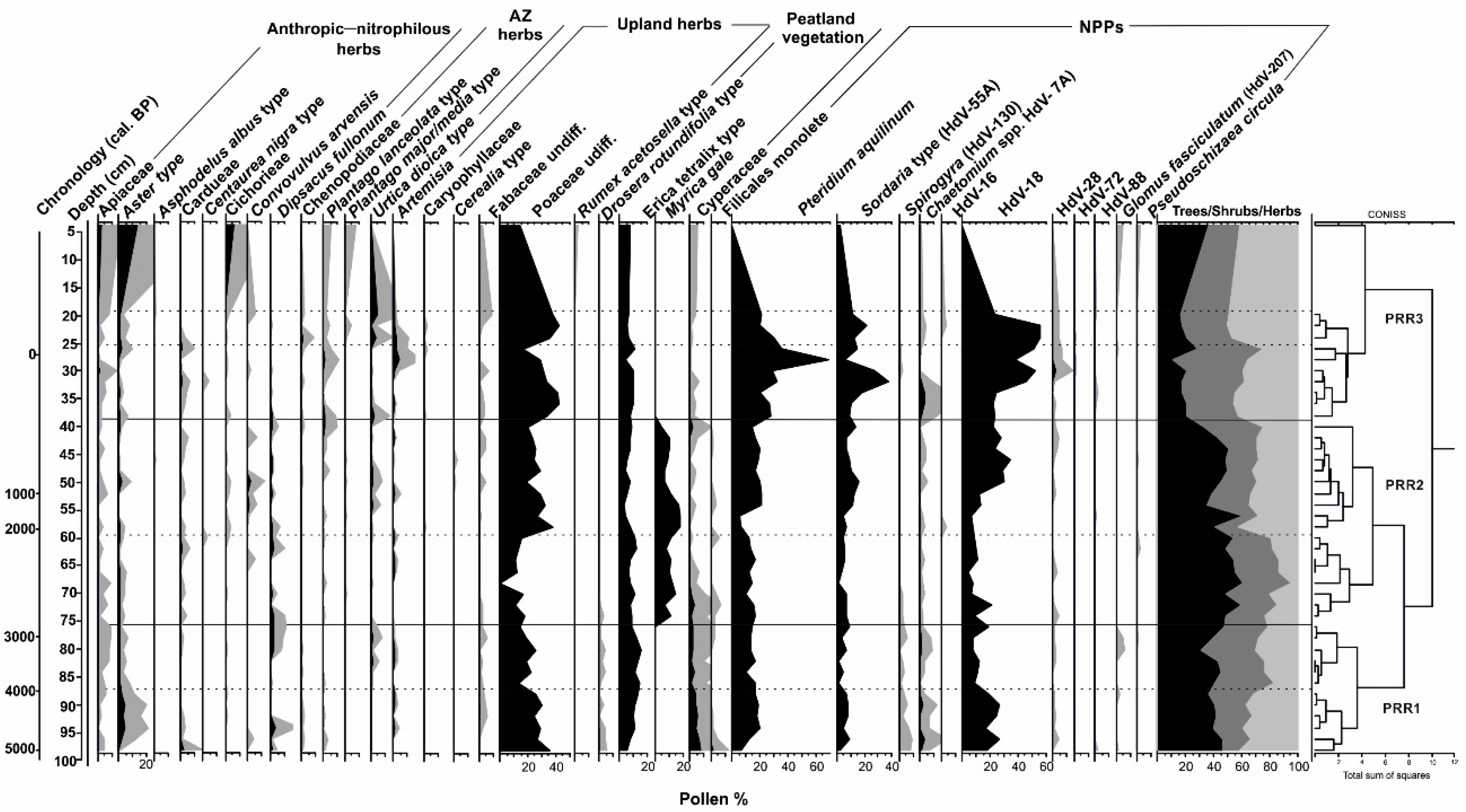
3.2. Pollen Analysis

For the El Perro sequence, 54 pollen types were identified. To facilitate the description and interpretation of the pollen diagrams with respect to vegetation changes, three local pollen assemblage zones (LPAZs) were established (Figure 3 and Figure 4). These zones denote significant changes in the pollen composition and represent major changes in vegetation.
The first pollen zone PRR1 comprises the basal 20 cm of the sequence (100–80 cm; approximately 5200–3200 cal. BP). This pollen zone can be divided into two different sub-zones. PRR1A includes samples from 100 to 89 cm (approximately 5200–4150 cal. BP) and PRR1B encompasses from 89 to 80 cm (approximately 4150–3200 cal. BP). From a cultural point of view, PPR1 belongs to the regional Chalcolithic period (approximately 5250–4200 cal. BP) and part of the Bronze Age (approximately 4150–2800 cal. BP). PRR1A shows a wide Quercus population, as deciduous species are better represented with percentages around 15–20%. Otherwise, evergreen Quercus shows a slight descending trend (13–9.3%). Besides, Pinus sylvestris type also shows notable percentages (>10%), but its values are not enough to consider the possibility of local pinewood but regional pollen deposition [68]. Between the arboreal layer, it is possible to distinguish Betula and Corylus (2.6% and 6.4%, respectively). Taking advantage of the trees decreasing dynamic, shrubs, dominated by Erica arborea type, progressively increased (10.8–29.9%). Herbs also show a similar behavior, with Poaceae the best represented (29.7%). It is necessary to mention the constant but discrete presence of anthropic–nitrophilous (Apiaceae, Aster, Asphodelus albus, Cardueae, Centaurea nigra, Cichorieae, Convolvulus arvensis, Dipsacus fullonum) and anthropozoogenous herbs (Chenopodiaceae, Plantago lanceolata, Plantago major/media, Urtica dioica), indicating, along with coprophilous fungi (Chaetomium, Sordaria, Sporormiella), human exploitation of this environment. Erica tetralix also shows an increasing trend, as do Pteridium aquilinum (4.9–12.7% and 6.1–17%, respectively); meanwhile, Cyperaceae and Drosera progressively decrease (8.3–5%). HdV-18 is represented by relatively high values through the zone (15–20%). PRR1B is also dominated by trees, which show an initial decrease (<40%) followed by an increase (approximately 45%) and another subsequent detriment (30%). Corylus and Betula reappear again; meanwhile Quercus (both evergreen and deciduous morphotypes) show a descending trend (11.1–10.6% and 10.5–3.3%, respectively). Erica arborea type follows a contrary pattern to that of trees. Helianthemum, Calluna vulgaris and Artemisia show an increasing trend, while HdV-18, the above mentioned anthropic–nitrophilous herbs and coprophilous fungi show a decreasing pattern.
Pollen zone PRR2 extends through almost 40 of the central core’s centimetres (80–43 cm; approximately 3205–270 cal. BP). From a cultural point of view, this stretches from the end of the Bronze Age (4150–2800 cal. BP) to the Modern Age (approximately 500–150 cal. BP). This pollen zone can be also divided into two pollen sub-zones: PRR2A (80–63 cm; 3205–2480 cal. BP) and PRR2B (63–43 cm, 2480–270 cal. BP). PRR2A shows an evident increase in Corylus and Betula percentages, as the latter are more present in the landscape (21.3% and 22.9%, respectively). It is possible to note an increase in riparian trees (Alnus, Fraxinus, Populus, Salix) and also an evident decreasing trend in Pinus sylvestris type: its maximum in this period corresponds to 19.9% but it this decreases to 11.1% in the end of the pollen subzone. Instead, Pinus pinaster progressively increases. Quercus trends are also descending, and their percentages, (both evergreen and deciduous Quercus) oscillates between 2–6%. There is more shrub variety (Arbutus unedo, 1.7%; Helianthemum, 1.5%, Cytisus/Genista, 4.1%). Myrica gale sharply appears in the 75 cm sample at 11.7%, but it is possible to assess a decreasing dynamic in Cyperaceae (3.7–0%). PRR2B shows the opposite relationship between Corylus and Betula, with the former being dominant (34% vs. >23% for Betula). The percentages of pines are reduced sharply to negligible values, while both evergreen and deciduous Quercus show an increasing but discrete trend (deciduous Quercus increases from 1.3% to 8.1%). Shrubs are still very present in the landscape but they follow an opposite trend to Corylus and Betula, which is visible in Erica arborea dynamics (maximum 24.4%). Herbs are dominant in the landscape but they show a very irregular trend, which is especially evident in Poaceae percentages (37.9%). Myrica gale decreases abruptly (18.5–10.3%) and Erica tetralix and Pteridium aquilinum spread (10–7% and 5.2–20%, respectively). Humid indicators (Filicales monolete, Cyperaceae, HdV-18) show an evident increasing trend.
Pollen zone PRR 3 comprises the upper part of the core (43–1 cm; approximately 270 to the present). This pollen zone includes the second half of the Modern Age (500–150 cal. BP) and also the whole Contemporary Age (150 cal. BP–present day). It has been also divided in two pollen sub-zones: PRR3A (43–25 cm; 270 cal. BP to –15 cal. BP) and PRR3B (25–1 cm, –15 cal. BP to the present). PRR3A shows great arboreal coverage (61.3%), although the trend decreases to around 20%. The shrub layer is 52.9%, while herbs are not very present at this moment (24%). The most evident change happened when Corylus, Betula, and Myrica gale percentages decrease until they disappear (11%, 2.9% and 4.2%, respectively) in the first half of the sub-zone. The left space is quickly dominated by deciduous Quercus whose trend wanders from 5–15%. There is evidence of Pinus species but not enough to be considered regional deposition. A variety of shrubs are still present but Erica arborea dominates the ensemble (44.7%). There is evidence of human pressure (noteworthy presence of anthropic nitrophilous herbs, anthropozoogenous herbs and coprophilous fungi), and Poaceae levels increase (42.5%). Pteridium aquilinum shows a sharp increase while Erica tetralix decrease. PRR3B shows an open landscape (tree percentages do not reach 20%) where Quercus are the most spread taxa (deciduous Quercus is dominant at 9.3%). Erica arborea is the most representative shrub in this moment but Poaceae dominate the landscape (42.8%).

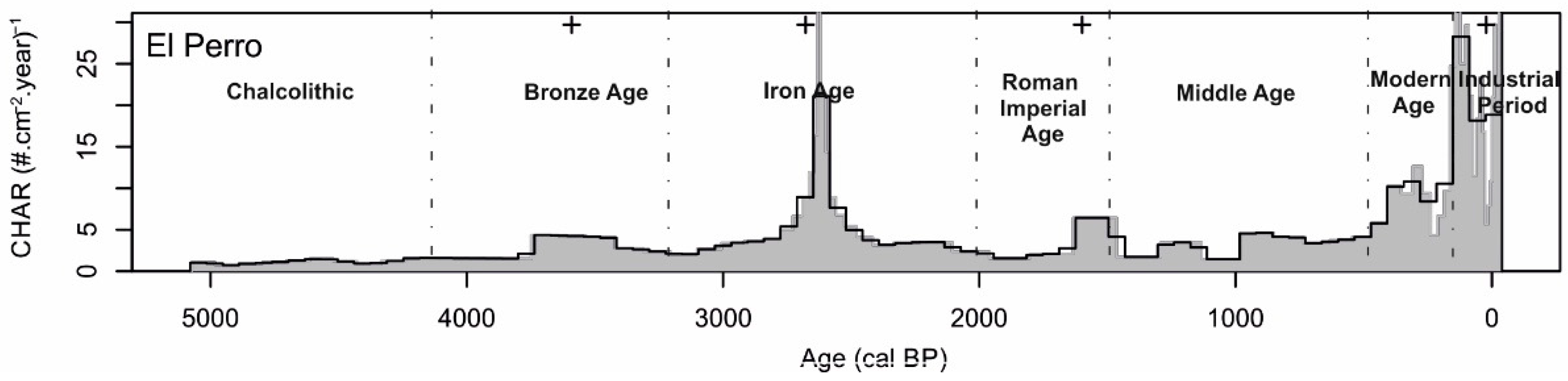
3.3. Charcoal Analysis

The median CHAR value is 2.886 # cm−2 year−1, with charcoal influxes showing an overall gentle increasing trend along the core (Figure 5). However, we can distinguish three main periods: (i) from approximately 5200 to approximately 3800 cal. BP, marked by low CHAR values ranging from 0.7 # cm−2 year−1 in approximately 4888 cal. BP to 1597 # cm−2 year−1 in approximately 4120 cal. BP; (ii) from approximatey 3800–500 cal. BP with CHAR values higher than in the first period, with a median value of 3.4 # cm−2 year−1; (iii) the last period shows an evident increasing trend (median CHAR values around 10 # cm−2 year−1) showing an intense fire activity at approximately 88 cal. BP with 28.28 # cm−2 year −1 (Figure 5). In the second period, it is possible to find a moderate fire event around 3600 cal. BP (4.4 # cm−2 year−1), an intense episode at approximately 2600 cal. BP, when there is a peak of 21.099 # cm−2 year −1, and one last moderate episode around 1500 cal. BP (6.43 # cm−2 year −1).

4. Discussion

The palynological sequence of El Perro mire allows us to reconstruct the environmental history of the southern Toledo Mountains during the last 5200 years (Figure 3, Figure 4 and Figure 6). Changes were triggered by climatic influences but human activity resulted in interesting variations in the general trends, especially closer to the present.

4.1. A Human and Natural Crisis in the Chalcolithic–Bronze Age Transition? (Approximately 5250–4200 cal. BP/Approximately 3300–2250 cal. BP)

The lower section of El Perro mire sequence dates back to the regional Chalcolithic period (approximately 5250–4200 cal. BP) [69,70,71]. At this time, a forested but relatively open landscape (trees <50%) predominates, mainly composed of deciduous and evergreen Quercus woodlands with Erica arborea and developed herbaceous understory (Figure 6). Among these herbs, Poaceae played a major role but species associated with human activities—such as anthropic–nitrophilous and anthropozoogenous taxa as well as coprophilous fungi—were also important. The presence of the latter increased throughout the period under study, attesting to growing human influence, although their abundances were not too high in general. At this time, the Chalcolithic population was still linked to Neolithic practices and related to megalithic sites [72,73]. Most of the Copper Age settlements were located along the communication routes, with the Tagus River playing a leading role in population movements and trade dynamics [74]. These patterns only experienced certain changes at the end of the period, when a climatic shift to humid conditions, as suggested by the increase in HdV-18 in the El Perro sequence, forced the Chalcolithic people to relocate their settlements high in the mountains. This resilient strategy allowed human communities to succeed under these new climatic conditions. In any case, it is worth stressing how sparsely populated Toledo Mountains were at this time [69,75], which would explain the limited signs of human impact in the El Perro record. However, this apparent abandonment highlights, in light of the results, the importance of a medium-altitude mountain range as a stock of resources, especially for livestock activities and hunting–gathering strategies. From a climatic point of view, the presence of birch, hazel and other plant species typical of peatlands (e.g., Drosera, Erica tetralix, Cyperaceae), alongside the high values of HdV-18 (Figure 6), would be indicative of a relatively humid period, at least locally [29,45,71].
The aforementioned plant dynamics changed substantially between 4200 and 3800 cal. BP, mainly forced by climate. From a palynological point of view, deciduous Quercus decreased while evergreen Quercus increased. Olea europaea and Erica arborea spread, whilst Betula and Corylus practically disappeared; meanwhile anthropic–nitrophilous and anthropozoogenous herbs were almost absent and coprophilous fungi and Poaceae also decreased (Figure 6). Within the peat bog vegetation, Calluna vulgaris and Erica tetralix increased their abundances at the expense of Drosera, Cyperaceae and HdV-18. All these data would point to a fundamentally dry period when the mire would have been colonized by heaths (including maximum values of Helianthemum; Figure 3) that usually occupy the most external and xerophilous zones of these wetlands [22]. Fire activity stepped up in the mire surroundings, as suggested by CHAR values and the increase in fire frequency (Figure 5). All these changes could be related to the so-called 4.2 ka cal. BP event (approximately 4300–3800 cal. BP), corresponding—in the Toledo Mountains—to a profound cultural shift: the Chalcolithic/early Bronze Age transition [70,71]. Although this event was not constant and homogeneous in southwestern Europe, it was characterized by a marked aridity in the southern Iberian Peninsula [69,70,71,76,77,78]. These changes suggest the reduction of human influence on the landscape and the resilient choice of the dwellers of abandoning their settlements and migrating [71,77].
When this 4.2 ka cal. BP arid episode came to its end around 3800 cal. BP, the landscape changed once again until approximately 2800 cal. BP during the middle and late Bronze Age (Figure 6). Deciduous Quercus increased whilst evergreen Quercus reduced their abundance. Corylus and Betula not only reappeared, but significantly spread around the study site taking advantage of the humid conditions reestablished after the end of the abrupt 4.2 ka cal. BP climatic event, becoming key elements in the landscape. The increases in HdV-18 and Drosera percentages and the reduced importance of the shrubs, especially Erica arborea and Helianthemun, but also other species linked to xeric conditions, point in this direction as well. However, it is important to note that Calluna vulgaris and Erica tetralix kept their importance in the mire vegetation. This suggests that the previous abrupt climatic event had a huge impact on the hydrological conditions of the peat bog, probably causing a new configuration at the mesoscale. Therefore, although the peat bog seems to have recovered its pre-event conditions—showing resilience to its effects—it was profoundly altered. The increase of human activity markers (anthropic–nitrophilous, anthropozoogenous herbs and coprophilous fungi) and the expansion of pasturelands (increase of Poaceae) indicate the recovery of the local human population and its intervention in the mire surroundings during the middle/late Bronze Age. Hence we can conclude that the 4.2 ka cal. BP event had a very important impact on vegetation dynamics and human settlements in the study site. Both cases saw a resilient response; the cultural dynamics led to the collapse of the Chalcolithic world, the migration to other territories of the early Bronze Age communities, and the subsequent recolonization of the study site from the middle Bronze Age. In fact, the population increased in the Toledo Mountains [23,69] during the middle and late Bronze Age (approximately 3800–2800 cal. BP) as well as the pressure on the landscape, as shown in the pollen diagrams (Figure 3, Figure 4 and Figure 6). These first settlements of metallurgic communities were marked by their wide diversity. They were established in many of the sites they had previously occupied—especially in the lowlands and river courses—but also spreading throughout the mountains. Elevated settlements focused on livestock activities were especially important [79,80,81,82]. These new locations were not necessarily interconnected or contemporary, but stone was used as the major building material in most of them because of the consolidation of the sedentary lifestyle. In the Toledo Mountains, this dual model (lowlands vs. mid-elevation mountains) is related to the exploitation of copper mines, the cultivation on river floodplains and the territorial control [83]. These settlements—the smallest ones in the Toledo Mountains southern slopes—tried to adapt to the rugged topography and sought the best exploitation opportunities. In the Bronze Age, the economy focused on livestock and agriculture, but also in metallurgical and lithic resources, especially in the South and West [23]. The search for mineral resources entailed high mobility, in parallel to the movements of livestock [83].

4.2. Resilience and Cultural Dynamics during the Iron Age. (ca. 3200-2000 cal. BP/ ca. 1250-50 BC)

The beginning of the Iron Age (approximately 3200–2000 cal. BP, divided into Early Iron Age (3200–2400 cal. BP) and Late Iron Age, (2400–2000 cal. BP)) is marked by the climatic event 2.8 ka cal. BP [79,80]. At this time, the landscape was still mostly forested and humid conditions favored the spread of Corylus and Betula. Birch spread, however, was also facilitated by fire activity in the mire surroundings (Figure 3, Figure 5 and Figure 6). Enhanced fire activity left a minute trace in the magnetic susceptibility values (Figure 6). Deciduous Quercus communities were still relevant but were no longer a preeminent landscape component, whilst the evergreen Quercus resilience was unable to cope with the previous event. The increase in tree coverage outcompeted shrubs and herbs, although Poaceae were still present in the landscape and Cyperaceae spread during the climatic event. The landscape was then composed of birch–hazel stands with a diverse understory. Pastureland were relatively rare during this period (Figure 3, Figure 4 and Figure 6).
All these landscape transformations were the consequence of the climatic conditions, marked by the climatic event in 2.8 ka cal. Heavy rainfall and low temperatures were its key features [84,85,86], as shown by the increase in humid indicators (HdV-18) in El Perro mire. These conditions had a clear impact on the composition and distribution of plant and human communities [72,85,87]. The 2.8 ka cal. BP event brought along changes in settlement patterns, socio-economic dynamics and material elements. The dwellers stayed in those sites at higher altitudes, and settlements in the lower sections of the valleys and the lowlands were abandoned [72,75]. This change triggered a demographic expansion through inter-fluvial lands, avoiding great basins and targeting fluvial terraces.
During the Late Iron Age (2400–2000 cal. BP), for the first time, tree cover showed an evident declining trend, although Corylus and Betula were still the most representative species. During the first part of this period, birch expanded at the expense of hazel when the climatic event ended. At the end of the Late Iron Age, coinciding with the Roman Warm Period [71,88] and its humid phase, the trend of these two species reverses as Quercus were almost absent in the ensemble and the regional Pinus also decreased and even disappeared. Shrubs were not particularly abundant during this period, but the growing presence of the herbaceous communities is evident in the Poaceae pasturelands. At the end of the Late Iron Age, the anthropic–nitrophilous herbs and livestock indicators increased, highlighting major human pressure in the mire surroundings (Figure 3, Figure 4 and Figure 6).
The Late Iron Age was the final stage of the cultural and economic changes of the previous period. The Toledo Mountains belonged to the land occupied by the Carpetans according to Roman historians [89,90]. The population created a broad network of settlements along the major communication routes, with the Tagus and Guadiana rivers and the Atlantic influence coming from the west being especially relevant [90]. The most common settlements were still located at the highest locations but the strategic territorial control and the defensive potential became essential for the dwellers. The population increased in this period and this growth was reflected in a higher number of settlements of larger size, and in the constant human pressure on the landscape (Figure 3, Figure 4 and Figure 6). According to some authors, this population rise was related to numerous migrations during the Iron Age [90] and a change in the productive skills. The introduction of iron in the agricultural practices helped the communities to increase their production in a more effective way, facilitating their development [89].

4.3. From the Roman Imperial Age Period to the Modern Age: Human Control and Climatic Forces (Approximately 2000–150 cal. BP/50 cal. BC–1800 cal. AD)

The Roman Imperial Age found the Carpetan population well established, making the conquest of these lands particularly challenging [89,90,91]. At this time, the landscape was dominated by hazel stands (Figure 3, Figure 4 and Figure 6). Their expansion began in the earlier period, supported by the humid conditions featured at the beginning of the Roman Warm Episode (2660–1450 cal. BP) [92,93]. Hazel reached its highest percentages in this time, regaining the space left by the anthropic communities when the demographic pattern changed. The Roman conquest forced the abandonment of most settlements located at high altitudes and the population returned to the lowlands where their defense was weaker, and their control was easier. Hazel regained the space previously occupied by the Poaceae pastureland for livestock (Figure 3, Figure 4 and Figure 6). At this time, evergreen Quercus and cork oaks show a slight recovery, suggesting the economic interest in those species and the impact of the abovementioned arid phase of the Roman Warm Episode [93].
The trend changed when hazel began to disappear and the pasturelands and shrubs spread, taking advantage of the situation. This modification of the landscape was forced by a rise in humid conditions in the mire surroundings, compromising hazel resilience, as highlighted by the increase of humid indicators (HdV-18) (Figure 3, Figure 4 and Figure 6). This is the moment when livestock returned to the mire, as shown by the increase in pasturelands, anthropic–nithrophilous herbs and coprophilous fungi. These transformations were a result of the changing economy and the spread of many villae along the territory, focused on cereal and olive cultivation [94]. Despite the fact that there is no trace of cereals in the mire surroundings, olives were more present in this final stage of Roman ruling (Figure 3, Figure 4 and Figure 6).
The end of the Roman Imperial Age was climatically marked by the arrival of the Early Medieval Cold Episode (1450–1050 cal. BP) [93,95], which lasted until the onset of the Medieval Climatic Anomaly (1050–650 cal. BP). This climatic episode brought arid and warm conditions, ending the previous cold period [95,96]. During the Early Middle Ages, the landscape was still dominated by trees, mostly hazel and birch. The humid conditions forced decreases in Olea europaea and deciduous Quercus. However, in the first half of this cultural period, it is interesting to focus on the Islamic Period (1239–850 cal. BP) [28,29,97]. Although the anthropic impact was slight on the mire surroundings, livestock was important in the Muslim economy [98,99,100,101]. Despite the decreasing trend in pasturelands, Poaceae were still dominant in the undergrowth and the flocks were close to the mire as shown by the coprophilous fungi and the spread of anthropic–nithrophilous and anthropozoogenous herbs.
However, human exploitation intensified during the Christian Period (850–500 cal. BP). After the Castilian conquest, the population grew in the area when the repopulation movements tried to keep the peace in the new territories [102]. The demographic growth is evident in the appearance of cereal cultivation (even though they were not present in the mire surroundings) and the spreading of crops into the mountains, taking into account lands that had never been exploited before (Figure 4 and Figure 6). CHAR and other fire indicators present higher values as well, reflecting the regional increase in the use of fire, linked to the war but also to environmental management and climatic conditions, especially in the Late Middle Age (Figure 4, Figure 5 and Figure 6). Anthropic–nithrophilous herbs and livestock indicators increased during this period, together with Poaceae pasturelands. Sheep flocks became the most important economic resource in the Castilian kingdom, and transhumance movements, led by La Mesta Council, moved from summer to winter grasslands using the cattle roads. One of them, the Cañada Real Segoviana, crosses close to the studied site, which probably became an available water point in the pathway [102,103,104].
The Modern Age (500–150 cal. BP) is marked by the Little Ice Age (600–150 cal. BP) [105]. This was not a constant climatic event but showed certain alternation of arid and humid phases, something evident in the Toledo Cathedral archive, where some documents are kept that show praying for the end of the rains and the droughts [5,6,7]. These alternative phases [93,95,105] affected the landscape, especially the arid stages that pushed hazel and birch communities towards their local extinction. In short, the pollen record of El Perro demonstrates the definitive disappearance of both birch and hazel around the study site, related both to a substantial increase in human impact and to the effects of the Little Ice Age. This forest change is also visible in other studied sites such as El Brezoso Mire [28]. Quercus communities subsequently expanded, taking advantage of the abandoned space and becoming the dominant trees in the landscape. However, shrubs (i.e., Ericaceae) and the pasturelands were the main elements in the new open landscape. In this new scenario, anthropic pressure over the landscape was intense, as they highlight the increase of fire activity (Figure 5) and the rise of anthropozoogenous and anthropic–nithrophilous herbs. Livestock was the most important economic resource and its presence around the mire shows the main role played by those flocks in the local economy [29,106].

4.4. Contemporary Age: The Final Trick (Approximately 150 cal. BP–Present/Approximately 1800 cal. AD–Present)

The Contemporary Age (150 cal. BP–present) is the period when the current landscape was shaped. The influence of the Little Ice Age was no more but the economic activities and the political decisions made during the first years of this cultural period had a strong impact on the mire surroundings. After the disappearance of Corylus and Betula during last arid phase of the Little Ice Age, the main trees were deciduous and evergreen Quercus.
However, despite the climatic influence in the abovementioned changes, there was already an intense anthropic intervention in the landscape. During this period, intense demographic growth translated into a heavier exploitation of the natural resources. This is visible in the El Perro pollen diagram (Figure 3, Figure 4 and Figure 6) where the anthropic markers show an increasing trend, but also in the abovementioned El Brezoso mire [31]. Those changes, on the other hand, were also related to policies promoted in the first part of the Contemporary Age. Confiscation laws were promoted in an attempt to change the property of many of the lands and triggering the exploitation of these mountainous lands [28,30,107,108]. Fire became the most important tool for this new management strategy as shown by the increasing CHAR values and fire frequency (Figure 5). Olea cultivation in the region left a notable imprint in the mire pollen reconstruction (Figure 3 and Figure 6).
Livestock stayed active in the region but lost importance in the local economy during the last century, with agriculture being the most important economic activity around. However, cattle presence was still constant and the use of the mire as a water supply point kept the livestock activity in the studied site. Shrubs spread, recovering the space previously occupied by pasturelands. In the 20th century AD, crops spread around the mire. Here and now, the landscape is open, the mire is surrounded by crops and the threats affecting El Perro mire come from the agricultural practices which began in the last century: dryness and agrochemicals, water loosing, and animal presence fragmented the mire and made it reduce in size and location. Some little active points are still creating peat, but the original mire will have been higher in the past. The mire was big enough to generate a trace in the cartography, but is forgotten today and lost to the crops.

5. Conclusions

The Toledo Mountains have proved to be a surprising landscape into which natural drivers and human intervention have contributed. Vegetation and human communities have faced different hazards along the way through history, adapting themselves and reaching resilience through many strategies, leaving a trace in the landscape. However, sometimes, that resilience has been impossible to reach and that failure is also traceable in the ensemble.
El Perro mire is one of the most relevant mires in the southern Toledo Mountains. It shows the main importance of climatic changes in the shaping of the landscape but also how the resilience could be threatened when human management crosses the climatic influence. Today, this mire is totally fragmented and endangered because of the intensive use of human groups. In the past, this mire covered enough surface to leave a trace in the cartography, but today, there is almost no active mires in the area.
The current vegetation comprises an open landscape mainly integrated by crops and shrubs dominating the area, with some mixed Quercus forests at the mire’s edges. In the past, and as a consequence of the climatic events happening in the Bronze Age, the mire surroundings were occupied by a hazel and birch forest. This ensemble showed a noticeable resilience against some climatic events compromising their survival, despite the more intense human intervention in the mire’s surroundings. Climatic changes and human management made these vegetal formations disappear from the landscape, causing it to become agricultural land where livestock and fire were the major drivers of change.

Author Contributions

Conceptualization, R.L.-L., S.P.-D. and J.A.L.-S.; Data curation, R.L.-L. and C.M.-M.; Formal analysis, R.L.-L. and O.B.; Funding acquisition, J.A.L.-S.; Investigation, R.L.-L.; Resources, C.M.-M.; Software, O.B.; Supervision, O.B., S.P.-D. and J.A.L.-S.; Writing – original draft, R.L.-L.; Writing – review & editing, O.B., S.P.-D., C.M.-M. and J.A.L.-S.

Funding

This research was funded the project REDISCO-HAR2017-88035-P (Plan Nacional I+D+I, Spanish Ministry of Economy and Competitiveness). Reyes Luelmo Lautenschlaeger is funded by a FPU contract (Spanish Ministry of Education, Culture and Sports).

Conflicts of Interest

The authors declare no conflict of interest.

References

  1. Arianoutsou, M.; Leone, V.; Moya, D.; Lovreglio, R.; Delipetrou, P.; De Heras, J. Management of Threatened, High Conservation Value, Forest Hotspots Under Changing Fire Regimes. In Post-Fire Management and Restoration of Southern European Forests; Moreira, F., Arianoustou, M., Corona, P., De las Heras, J., Eds.; Springer: Amsterdam, The Netherlands, 2012; pp. 257–291. [Google Scholar]
  2. Pyne, S.J. Eternal Flame: An Introduction to the Fire History of the Mediterranean. In Earth Observation of Wildland Fires in Mediterranean Ecosystems; Chuvieco, E., Ed.; Springer: Berlin/Heidelberg, Germany, 2009; pp. 11–26. [Google Scholar]
  3. Jiménez-Moreno, G.; García-Alix, A.; Hernández-Corbalán, M.D.; Anderson, R.S.; Delgado-Huertas, A. Vegetation, fire, climate and human disturbance history in the southwestern Mediterranean area during the late Holocene. Quat. Res. 2013, 79, 110–122. [Google Scholar] [CrossRef]
  4. Vannière, B.; Power, M.J.; Roberts, N.; Tinner, W.; Carrión, J.; Magny, M.; Bartlein, P.; Colombaroli, D.; Daniau, A.L.; Finsinger, W.; et al. Circum-Mediterranean fire activity and climate changes during the mid-Holocene environmental transition (8500–2500 cal. BP). Holocene 2011, 21, 53–73. [Google Scholar] [CrossRef]
  5. Domínguez-Castro, F.; Santisteban, J.I.; Barriendos, M.; Mediavilla, R. Reconstruction of drought episodes for central Spain from rogation ceremonies recorded at the Toledo Cathedral from 1506 to 1900: A methodological approach. Glob. Planet. Chang. 2008, 63, 230–242. [Google Scholar] [CrossRef] [Green Version]
  6. Domínguez-Castro, F.; García-Herrera, R.; Ribera, P.; Barriendos, M. A shift in the spatial pattern of Iberian droughts during the 17th century. Clim. Past 2010, 6, 553–563. [Google Scholar] [CrossRef] [Green Version]
  7. Rodrigo, F.S.; Barriendos, M. Reconstruction of seasonal and annual rainfall variability in the Iberian Peninsula (16th–20th centuries) from documentary data. Glob. Planet. Chang. 2008, 63, 243–257. [Google Scholar] [CrossRef]
  8. López-Sáez, J.A.; Vargas, G.; Ruiz-Fernández, J.; Blarquez, O.; Alba-Sánchez, F.; Oliva, M.; Pérez-Díaz, S.; Robles-López, S.; Abel-Schaad, D. Paleofire dynamics in central Spain during the Late Holocene: The role of climatic and antrhopogenic forcing. Land Degrad. Dev. 2018, 29, 2045–2059. [Google Scholar] [CrossRef]
  9. Naveh, Z. The evolutionary significance of fire in the mediterranean región. Vegetatio 1975, 29, 199–208. [Google Scholar] [CrossRef]
  10. Rodrigo, A.; Retana, J.; Pico, F.J. Direct regeneration is not the only response of mediterranean forests to large fires. Ecology 2004, 85, 716–729. [Google Scholar] [CrossRef]
  11. Pausas, J.; Llovet, J.; Rodrigo, A.; Vallejo, R. Are wildfires a disaster in the Mediterranean basin?—A review. Int. J. Wildland Fire 2008, 17, 713–723. [Google Scholar] [CrossRef]
  12. Leys, B.; Carcaillet, C.; Dezileau, L.; Ali, A.A.; Bradshaw, R.H.W. A comparison of charcoal measurements for reconstruction of Mediterranean paleo-fire frequency in the mountains of Corsica. Quat. Res. 2013, 79, 337–349. [Google Scholar] [CrossRef]
  13. Pausas, J.G.; Keeley, J.E. Wildfires as an ecosystem service. Front. Ecol. Environ. 2019, 17, 289–295. [Google Scholar] [CrossRef] [Green Version]
  14. Montiel-Molina, C.; Galiana-Martín, L. Fire Scenarios in Spain: A Territorial Approach to Proactive Fire Management in the Context of Global Change. Forests 2016, 7, 273. [Google Scholar] [CrossRef]
  15. Connor, S.E.; Vanière, B.; Colombaroli, D.; Anderson, R.S.; Carrión, J.S.; Ejarque, A.; Gil-Romera, G.; González-Sampériz, P.; Hoefer, D.; Morales-Molino, C.; et al. Humans take control of fire-driven diversity changes in Mediterranean Iberia’s vegetation during the mid-late Holocene. Holocene 2019, 29, 886–901. [Google Scholar] [CrossRef]
  16. Burjachs, F.; Expósito, I. Charcoal and pollen analysis: Examples of Holocene fire dynamics in Mediterranean Iberian Peninsula. Catena 2015, 135, 340–349. [Google Scholar] [CrossRef]
  17. Pérez, B.; Cruz, A.; Fernández-González, F.; Moreno, J.M. Effects of the recent land-use history on the postfire vegetation of uplands in Central Spain. For. Ecol. Manag. 2003, 182, 273–283. [Google Scholar] [CrossRef]
  18. Bond, W.J.; Woodland, F.I.; Midgley, G.F. The global distribution of ecosystems in a world without fire. New Phytol. 2004, 165, 525–538. [Google Scholar] [CrossRef] [PubMed]
  19. Ouarim, S.; Paradis, L.; Asselin, H.; Bergeron, Y.; Ali, A.A.; Hély, C. Burning Potential of Fire Refuges in the Boreal Mixedwood Forest. Forests 2016, 7, 246. [Google Scholar] [CrossRef]
  20. McLaughlin, B.C.; Ackerly, D.D.; Klos, P.Z.; Natalli, J.; Dawson, T.E.; Thompson, S.E. Hydrologic refugia, plants, and climate change. Glob. Chang. Biol. 2017, 23, 2941–2961. [Google Scholar] [CrossRef] [Green Version]
  21. Carrión, J.S.; Fernández, S.; González-Sampériz, P.; Gil-Romera, G.; Badal, E.; Carrión-Marco, Y.; López-Merino, L.; López-Sáez, J.A.; Fierro, E.; Burjachs, F. Expected trends and surprises in the Lateglacial and Holocene vegetation history of the Iberian Peninsula and Balearic Islands. Rev. Palaeobot. Palynol. 2010, 162, 458–475. [Google Scholar] [CrossRef] [Green Version]
  22. López-Sáez, J.A.; García-Río, R.; Alba-Sánchez, F.; García-Gómez, E.; Pérez-Díaz, S. Peatlands in the Toledo Mountains (central Spain): Characterisation and conservation status. Mires Peat 2014, 15, 1–23. [Google Scholar]
  23. López-Sáez, J.A.; Pérez-Díaz, S.; García-Gómez, E.; Alba-Sánchez, F. Historia de la Vegetación y los Paisajes de Toledo; Editorial Cuarto Centenario: Toledo, Spain, 2019; 379p. [Google Scholar]
  24. Dorado-Valiño, M.; López-Sáez, J.A.; García-Gómez, E. Patateros, Toledo Mountains (central Spain). Grana 2014, 53, 171–173. [Google Scholar] [CrossRef]
  25. Dorado-Valiño, M.; López-Sáez, J.A.; García-Gómez, E. Valdeyernos, Toledo Mountains (central Spain). Grana 2014, 53, 315–317. [Google Scholar] [CrossRef]
  26. Luelmo-Lautenschlaeger, R.; López-Sáez, J.A.; Pérez-Díaz, S. Las Lanchas, Toledo Mountains (central Spain). Grana 2018, 57, 246–248. [Google Scholar] [CrossRef]
  27. Luelmo-Lautenschlaeger, R.; López-Sáez, J.A.; Pérez-Díaz, S. Botija, Toledo Mountains (central Spain). Grana 2018, 57, 322–324. [Google Scholar] [CrossRef]
  28. Morales-Molino, C.; Colombaroli, C.; Tinner, W.; Perea, R.; Valbuena-Carabaña, M.; Carrión, J.S.; Gil, L. Vegetation and fire dynamics during the last 4000 years in the Cabañeros National Park (central Spain). Rev. Paleobot. Palynol. 2018, 253, 110–122. [Google Scholar] [CrossRef]
  29. Luelmo-Lautenschlaeger, R.; Pérez-Díaz, S.; Alba-Sánchez, F.; Abel-Schaad, D.; López-Sáez, J.A. Vegetation History in the Toledo Mountains (Central Iberia): Human Impact during the Last 1300 Years. Sustainability 2018, 10, 2575. [Google Scholar] [CrossRef]
  30. Morales-Molino, C.; Tinner, W.; Perea, R.; Carrión, J.S.; Colombaroli, D.; Valbuena-Carabaña, M.; Zafra, E.; Gil, L. Unprecedented herbivory threatens rear-edge populations of Betula in southwestern Eurasia. Ecology 2019, e02833. [Google Scholar] [CrossRef]
  31. Colombaroli, D.; Whitlock, C.; Tinner, W.; Conedera, M. Paleorecords as a guide for ecosystem management and biodiversity conservation. Past Glob. Chang. Mag. 2017, 25, 78–79. [Google Scholar] [CrossRef]
  32. Hennebelle, A.; Grondin, P.; Aleman, J.C.; Ali, A.A.; Bergeron, Y.; Borcard, D.; Blarquez, O. Using paleoecology to improve reference conditions for ecosystem-based management in western spruce-moss subdomain of Québec. For. Ecol. Manag. 2018, 430, 157–165. [Google Scholar] [CrossRef]
  33. Martín-Serrano, A.; Molina, E.; Nozal, F.; Carral, M.P.; Itinerario, A. Transversal en los Montes de Toledo. In Itinerarios Geomorfológicos por Castilla-La Mancha. Excursiones de la VIII Reunión Nacional de Geomorfología; Benito, G., Díez Herrero, A., Eds.; Sociedad Española de Geomorfología-CSIC Centro de Ciencias Medioambientales: Madrid, Spain, 2004; pp. 51–82. [Google Scholar]
  34. San Miguel, A.; Rodríguez-Vigal, C.; Perea García-Calvo, R. Los Quintos de Mora. Gestión integral del monte mediterráneo. In Pastos, Paisajes Culturales Entre Tradición y Nuevos Paradigmas del Siglo XXI. Visitas de Campo; López-Carrasco, C., Rodríguez, M.P., San Miguel, A., Fernández, F., Roig, S., Eds.; Sociedad Española para el Estudio de los Pastos: Madrid, Spain, 2011; 704p. [Google Scholar]
  35. Ninyerola, M.; Roure, J.M.; Fernández, X.P. Atlas Climático Digital de la Península Ibérica: Metodología y Aplicaciones en Bioclimatología y Geobotánica; Universitat Autònoma de Barcelona: Bellaterra, Spain, 2005; 45p. [Google Scholar]
  36. Luengo-Nicolau, E.; Sánchez-Mata, D. A hazel tree relict community (Corylus avellana L., Betulaceae) from the Guadiana River Middle Basin (Ciudad Real, Spain). Lanzaroa 2015, 36, 133–137. [Google Scholar] [CrossRef]
  37. Reimer, P.J.; Bard, E.; Bayliss, A.; Beck, J.W.; Blackwell, P.G.; Bronk Ramsey, C.; Buck, C.E.; Cheng, H.; Edwards, R.L.; Friedrich, M.; et al. Intcal13 and marine13 radiocarbon age calibration curves 0–50,000 years cal. BP. Radiocarbon 2013, 55, 1869–1887. [Google Scholar] [CrossRef]
  38. Hua, Q.; Barbetti, M. Review of tropospheric bomb 14C data for carbon cycle modelling and age calibration purposes. Radiocarbon 2004, 46, 1273–1298. [Google Scholar] [CrossRef]
  39. Blaauw, M. Methods and code for classical age-modelling of radiocarbon sequences. Quat. Geochron. 2010, 5, 512–518. [Google Scholar] [CrossRef]
  40. Blaaw, M. Available online: https://CRAN.R-project.org/package=clam (accessed on 11 October 2018).
  41. Moore, P.D.; Webb, J.A.; Collinson, M.E. Pollen Analysis; Blackwell: London, UK, 1991; 216p. [Google Scholar]
  42. Goeury, C.; de Beaulieu, J.L. À propos de la concentration du pollen à l’aide de la liqueur de Thoulet dans les sédiments minéraux. Pollen Spores 1979, 21, 239–251. [Google Scholar]
  43. Stockmarr, J. Tablets with spores used in absolute pollen analysis. Pollen Spores 1971, 13, 614–621. [Google Scholar]
  44. Reille, M. Pollen et spores d’Europe et d’Afrique du Nord, 2nd ed.; Laboratoire de Botanique Historique et Palynologie: Marseille, France, 1999; 543p, ISBN 2950717500. [Google Scholar]
  45. Van Geel, B. Non-pollen palynomorphs. In Tracking Environmental Change Using Lake Sediments, Vol. 3, Terrestrial, Algal, and Siliceous Indicators; Smol, J.P., Birks, H.J.B., Last, W.M., Eds.; Kluwer: Dordrecht, The Netherlands, 2001; pp. 99–119. [Google Scholar]
  46. Punt, W.; Marcks, A.; Hoen, P.P. Myricaceae. Rev. Paleaeobot. Palynol. 2002, 123, 99–105. [Google Scholar] [CrossRef]
  47. Beug, H.J. Leitfaden der Pollenbestimmung für Mittleleuropa und Angrenzende Gebeite; Gustav Fisher Verlag: Stuttgart, Germany, 2004; ISBN 9783899370430. [Google Scholar]
  48. Cugny, C.; Mazier, F.; Galop, D. Modern and fossil non-pollen palynomorphs from the Basque mountains (western Pyrenees, France): The use of coprophilous fungi to reconstruct pastoral activity. Veget. Hist. Archaeobot. 2010, 19, 391–408. [Google Scholar] [CrossRef]
  49. Blackmore, S.; Steinmann, J.A.J.; Hoen, P.P.; Punt, W. Betulaceae and Corylaceae. Rev. Paleaeobot. Palynol. 2003, 123, 71–98. [Google Scholar] [CrossRef]
  50. Mateus, J.E. Pollen Morphography of Portuguese Ericales. Revista Biología 1989, 14, 135–208. [Google Scholar]
  51. Grimm, E.D. TGView; Illinois State Museum, Research and Collection Center: Springfield, MA, USA, 2004. [Google Scholar]
  52. Grimm, E.C. Coniss: A Fortran 77 program for stratigraphically constrained cluster analysis by the method of incremental sum of squares. Comput. Geosci. 1987, 13, 13–35. [Google Scholar] [CrossRef]
  53. Bennett, K.D. Determination of the number of zones in a biostratigraphical sequence. New. Phytol. 1996, 132, 155–170. [Google Scholar] [CrossRef]
  54. Withlock, C.; Bartlein, P.J. Holocene fire activity as a record of past environmental change. Dev. Quat. Sci. 2004, 1, 479–490. [Google Scholar] [CrossRef]
  55. Whitlock, C.; Larsen, C. Charcoal as a fire proxy. In Tracking Environmental Change Using Lake Sediments, Vol. 3, Terrestrial, Algal, and Siliceous Indicators; Smol, J.P., Birks, H.J.B., Last, W.M., Eds.; Kluwer: Dordrecht, The Netherlands, 2001; pp. 75–97. [Google Scholar]
  56. Long, C.J.; Whithlock, C.; BArtlein, P.J.; Millspaugh, S.H. A 9000-year fire history from the Oregon Coast Range, based on a high-resolution charcoal study. Can. J. For. Res. 1998, 28, 774–787. [Google Scholar] [CrossRef]
  57. Carcaillet, C.; Bouvier, M.; Fréchette, B.; Laroouche, A.C.; Richard, P.J.H. Comparison of pollen-slide and sieving methods in lacustrine charcoal analyses for local and regional fire history. Holocene 2001, 11, 467–476. [Google Scholar] [CrossRef]
  58. Higuera, P.; Brubaker, L.B.; Anderson, P.A.; Sheng Hu, F.; Brown, T.A. Vegetation mediated the impacts of postglacial climate change on fire regimes in the south-central Brooks Range, Alaska. Ecol. Monogr. 2009, 79, 201–209. [Google Scholar] [CrossRef]
  59. Blarquez, O.; Vannière, B.; Marlon, J.R.; Daniau, A.-L.; Power, M.J.; Brewer, S.; Bartlein, P.J. Paleofire: An R package to analyse sedimentary charcoal records from the Global Charcoal Database to reconstruct past biomass burning. Comput. Geosci. 2014, 72, 255–261. [Google Scholar] [CrossRef]
  60. Higuera, P.E.; Gaving, D.G.; Bartlein, P.J.; Hallet, D.J. Peak detection in sediment-charcoal records: Impacts of alternative data analysis methods on fire-history interpretations. Int. J. Wildland Fire 2010, 19, 996–1014. [Google Scholar] [CrossRef]
  61. Long, C.J.; Withlock, C. Fire and Vegetation History from the Coastal Rain Forest of the Western Oregon Coast Range. Quat. Res. 2002, 58, 215–225. [Google Scholar] [CrossRef] [Green Version]
  62. Blarquez, O.; Girardin, M.P.; Leys, B.; Ali, A.A.; Aleman, J.C.; Bergeron, Y.; Carcaillet., C. Paleofire reconstruction based on an ensemble-member strategy applied to sedimentary charcoal. Geophys. Res. Lett. 2013, 40, 2667–2672. [Google Scholar] [CrossRef]
  63. Gavin, D.G.; Hu, F.S.; Lertzman, K.; Corbett, P. Weak climatic control of stand-scale fire history during the Late Holocene. Ecology 2006, 87, 1722–1732. [Google Scholar] [CrossRef]
  64. Kelly, R.F.; Higuera, P.E.; Barrett, C.M.; Sheng Hu, F. A signal-to-noise index to quantify the potential for peak detection in sediment–charcoal records. Quat. Res. 2011, 75, 11–17. [Google Scholar] [CrossRef]
  65. Schibler, L.; Boyko, T.; Ferdyn, M.; Gajda, B.; Höll, S.; Jordanova, N.; Rösler, W.; Magprox Team. Topsoil magnetic susceptibility mapping: Data reproducibility and compatibility, measurement strategy. Stud. Geophys. Geod. 2002, 46, 43–57. [Google Scholar] [CrossRef]
  66. Conedera, M.; Tinner, W.; Neff, C.; Meurer, M.; Dickens, A.F.; Krebs, P. Reconstructing past fire regimes: Methods, applications, and relevance to fire management and conservation. Quat. Sci. Rev. 2009, 28, 555–576. [Google Scholar] [CrossRef]
  67. Walden, J.; Oldfield, F.; Smith, J. Environmental Magnetism: A Practical Guide. Technical Guide No. 6; Quaternary Research Association: London, UK, 1999. [Google Scholar]
  68. López-Sáez, J.A.; Sánchez-Mata, D.; Alba-Sánchez, F.; Abel-Schaad, D.; Gavilán, R.G.; Pérez-Díaz, S. Discrimination of Scots pine forests in the Iberian Central System (Pinus sylvestris var. iberica) by means of pollen analysis. Phytosociological considerations. Lanzaroa 2013, 34, 191–208. [Google Scholar] [CrossRef]
  69. López-Sáez, J.A.; Blanco-González, A.; Pérez-Díaz, S.; Alba-Sánchez, F.; Luelmo-Lautenschlaeger, R.; Glais, A.; Núñez de la Fuente, S. Landscapes, Human Activities and Climate Dynamics in the South Meseta of the Iberian Peninsula during the 3rd and 2nd Millennia calBC. In Key Resources and Sociocultural Developments in the Iberian Chalcolithic; Bartelheim, M., Bueno-Ramírez, P., Kunst, M., Eds.; Tübingen Library Publishing: Tübingen, Germany, 2017; pp. 129–142. [Google Scholar]
  70. Lillios, K.T.; Blanco-González, A.; Lee, B.; López-Sáez, J.A. Mid-late Holocene climate, demography, and cultural dynamics in Iberia: A multiproxy approach. Quat. Sci. Rev. 2016, 135, 138–153. [Google Scholar] [CrossRef]
  71. Blanco-González, A.; Lillios, K.T.; López-Sáez, J.A.; Drake, B.L. Cultural, demo-graphic and environmental dynamics of the Copper and Early Bronze Age in Iberia (3300–1500 BC): Towards an interregional multiproxy comparison at the time of the 4.2 ky BP event. J. World Prehist. 2018, 31, 1–79. [Google Scholar] [CrossRef]
  72. Barroso-Bermejo, R.; Bueno-Ramírez, P.; Balbín-Behrmann, R. Primeras producciones metálicas en la cuenca interior del Tajo. Cáceres y Toledo. Estudos Pré-históricos 2003, 10, 87–107. [Google Scholar]
  73. Ramírez, P.B.; Bermejo, R.B.; de Balbín Behrmann, R. Agricultores y metalúrgicos en el Valle de Huecas (Toledo). In Arqueología, Medio Ambiente y Obras Públicas: El Valle de Huecas (Huecas, Toledo); Benítez de Lugo, L., Ed.; Anthropos: Valdepeñas, Spain, 2009; pp. 33–72. ISBN 978-84-613-0052-5. [Google Scholar]
  74. Ramírez, P.B.; Bermejo, R.B.; de Balbín Behrman, R.; Martín, M.C.; Gabilondo, F.E.; Martín, A.G.; Erlogorri, L.H.; Treserras, J.J.; García, P.L.; Sáez, J.A.L.; et al. Áreas habitacionales y funerarias en el Neolítico de la cuenca interior del Tajo. La provincia de Toledo. Trab. Prehist. 2002, 59, 65–79. [Google Scholar] [CrossRef]
  75. Muñoz, K. El poblamiento desde el Calcolítico a la Primera Edad del Hierro en el valle medio del río Tajo. Complutum 1993, 4, 321–336. [Google Scholar]
  76. Magny, M. Holocene climate variability as reflected by mid-European lake-level fluctuations and its probable impact on prehistoric human settlements. Quat. Int. 2004, 113, 65–79. [Google Scholar] [CrossRef]
  77. Sáez, J.A.L.; Sánchez, F.A.; Colino, T.N.; González, F.M.; Díaz, S.P.; Ruiz, S.S. Paleoambiente y sociedad en la Edad del Bronce de la Mancha: La Motilla del Azuer. CPAG 2014, 24, 391–422. [Google Scholar]
  78. Bini, M.; Zanchetta, G.; Persoiu, A.; Cartier, R.; Català, A.; Cacho, I.; Dean, J.R.; Di Rita, F.; Drysdale, R.N.; Finnè, M.; et al. The 4.2 la BP Event in the Mediterranean región: An overview. Clim. Past 2019, 15, 555–577. [Google Scholar] [CrossRef]
  79. Ruiz Taboada, A. Asentamiento y subsistencia en La Mancha durante la Edad del Bronce. El sector norocciedental como modelo. Complutum 1997, 8, 57–71. [Google Scholar]
  80. Ruiz Taboada, A. La Edad del Bronce en la Provincia de Toledo. La Mancha y su Entorno; Diputación de Toledo: Toledo, Spain, 1998.
  81. Fernández-Posse, M.D.; Gilman, A.; Martín, C. Consideraciones cronológicas sobre la Edad del Bronce en La Mancha. Complutum 1996, Extra 6 (II), 111–137. [Google Scholar]
  82. Fernández-Posse, M.D.; Gilman, A.; Martín, C.; Brodsky, M. Las Comunidades Agrarias de la Edad del Bronce en la Mancha Oriental (Albacete); Consejo Superior de Investigaciones Científicas, Instituto de Historia, Instituto de Estudios Albacetenses: Madrid, Spain, 2008. [Google Scholar]
  83. Ruiz-Taboada, A.; Montero, I. The pattern of use of stone and copper in central Spain during the Bronze Age. Eur. J. Archaeol. 2000, 3, 350–369. [Google Scholar] [CrossRef]
  84. López-Sáez, J.A.; Blanco, A. La mutación Bronce Final/Primer Hierro en el suroeste de la Cuenca del Duero (provincia de Ávila): ¿cambio ecológico y social? In Bronce Final y Edad del Hierro en la Península Ibérica; Blanco, A., Cancelo, C., Esparza, Á., Eds.; Universidad de Salamanca: Salamanca, Spain, 2005; pp. 229–250. [Google Scholar]
  85. López-Sáez, J.A.; Blanco-González, A.; López, L.; Ruiz, B.; Dorado, M.; Pérez, S.; Valdeolmillos, A.; Burjachs, F. Landscape and Climatic Changes during the End of the Late Prehistory in the Amblés Valley (Ávila, central Spain) from 1200 to 400 cal BC. Quat. Int. 2009, 200, 90–101. [Google Scholar] [CrossRef]
  86. López-Sáez, J.A.; Abel-Schaad, D.; Pérez-Díaz, S.; Blanco-González, A.; Alba-Sánchez, F.; Dorado-Valiño, M.; Ruiz-Zapata, B.; Gil-García, M.J.; Gómez-González, C.; Franco-Múgica, F. Vegetation history, climate and human impact in the Spanish Central System over the last 9000 years. Quat. Int. 2014, 353, 98–122. [Google Scholar] [CrossRef]
  87. Joanin, S.; Magny, M.; Peyron, O.; Vannière, B.; Galop, D. Climate and land-use change during the late Holocene at Lake Ledro (southern Alps, Italy). Holocene 2014, 24, 591–602. [Google Scholar] [CrossRef]
  88. Sánchez del Álamo, C.; Sardinero, S.; Bouso, V.; Hernández-Palacios, G.; Pérez-Badía, R.; Fernández-González, F. Los abedulares del Parque Nacional de Cabañeros: Sistemática, demografía, biología reproductiva y estrategias de conservación. In Proyectos de Investigación en Parques Nacionales: 2006–2009; Ramírez, L., Asensio, B., Eds.; Organismo Autónomo Parques Nacionales: Madrid, Spain, 2010; pp. 275–310. [Google Scholar]
  89. Hurtado-Aguña, J. Castros carpetanos de época prerromana. CuPacUAM 2000, 26, 85–93. [Google Scholar] [CrossRef]
  90. Dávila, F.A. Paisaje y poblamiento en la Carpetania. Un territorio en proceso de definición. Zona Arqueol. 2014, 17, 45–70. [Google Scholar]
  91. Carrasco-Serrano, G. La intervención romana en Castilla La Mancha. La anexión del territorio. In La romanización en el territorio de Castilla La Mancha; Carrasco-Serrano, G., Ed.; Ediciones de la Universidad de Castilla La Mancha: Cuenca, Spain, 2008; 383p, ISBN 978-84-8427-623-4. [Google Scholar]
  92. Martín-Puertas, C.; Valero-Garcés, B.L.; Brauer, A.; Mata, P.; Delgado-Huertas, A.; Dulski, P. The Iberian-Roman humid Period (2600-1600 cal yr BP) in the Zoñar Lake varve record (andalucía, southern Spain). Quat. Res. 2009, 71, 108–120. [Google Scholar] [CrossRef]
  93. Sánchez-López, G.; Hernández, A.; Pla-Rabes, S.; Trigo, R.M.; Toro, M.; Granados, I.; Sáez, A.; Masqué, P.; Pueyo, J.J.; Rubio-Inglés, M.J.; et al. Climate reconstruction for the last two millennia in central Iberia: The role of East Atlantic (EA), North Atlantic Oscillation (NAO) and their interplay over the Iberian Peninsula. Quat. Sci. Rev. 2016, 149, 135–150. [Google Scholar] [CrossRef] [Green Version]
  94. Sáez, J.A.L.; Chocarro, L.P.; Merino, L.L.; García, E.; Gómez SP, D.; García-Entero, V.; Ruano, R.C. Paisajes culturales de las villas romanas de Toledo. Cuadernos de la Sociedad Española de Ciencias Forestales 2009, 30, 101–106. [Google Scholar]
  95. García, M.J.G.; Zapata MB, R.; Santisteban, J.I.; Mediavilla, R.; López-Pamo, E.; Dabrio, C.J. Late holocene environments in Las Tablas de Daimiel (south central Iberian peninsula, Spain). Veget. Hist. Archaeobot. 2007, 16, 241–250. [Google Scholar] [CrossRef]
  96. Moreno, A.; Pérez, A.; Frigola, J.; Nieto-Moreno, V.; Rodrigo-Gámiz, M.; Martrat, B.; González-Sampériz, P.; Morellón, M.; Martín-Puertas, C.; Corella, J.P.; et al. The Medieval Climate Anomaly in the Iberian Peninsula reconstructed from marine and lake records. Quat. Sci. Rev. 2012, 43, 16–32. [Google Scholar] [CrossRef]
  97. Molenat, J.P. Campagnes et Monts de Tolede du XIIe au XVe Siècle; Casa de Velázquez: Madrid, Spain, 1997; 724p. [Google Scholar]
  98. Blanco-González, A.; López-Sáez, J.A.; López-Merino, L. Ocupación y uso del territorio en el sector centromeridional de la cuenca del Duero entre la Antigüedad y la Alta Edad Media (siglos I-XI d.C.). Archivo Español de Arqueología 2009, 82, 275–300. [Google Scholar] [CrossRef]
  99. Blanco-González, A.; López-Sáez, J.A.; Alba, F.; Abel, D.; Pérez, S. Medieval landscapes in the Spanish Central System (450–1350): A palaeoenvironmental and historical perspective. J. Mediev. Iber. Stud. 2015, 7, 1–17. [Google Scholar] [CrossRef]
  100. Carrobles, J.; Morín, J.; Rodríguez, S. La génesis de un paisaje medieval II: Los espacios ganaderos bajomedievales. In Alquerías, Cigarrales y Palacios: La Quinta de Mirabel; Carrobles, J., Morín, J., Eds.; AUDEMA S.A.: Toledo, Spain, 2016; pp. 115–134. ISBN 9788416450145. [Google Scholar]
  101. López-Sáez, J.A.; Abel-Schaad, D.; Robles-López, S.; Pérez-Díaz, S.; Alba-Sánchez, F.; Nieto-Lugilde, D. Landscape dynamics and human impact on high-mountain woodlands in the western Spanish Central System during the last three millennia. J. Archaeol. Sci. Rep. 2016, 9, 203–218. [Google Scholar] [CrossRef]
  102. Izquierdo-Benito, R. Monografías. Castilla la Mancha en la Edad Media; Servicio de Publicaciones de la JUNTA de Comunidades de Castilla La Mancha: Toledo, Spain, 1985; 160p, ISBN 9788450510485. [Google Scholar]
  103. Martín-Martín, J.L. El campesinado en los Montes de Toledo en los siglos XVIII y XIX. Beresit 2005, 5, 93–121. [Google Scholar]
  104. de Togneri, R.P. La lana en Castilla y León antes de la organización de la Mesta. In Contribución a la Historia de la Trashumancia en España; García Martín, P., Sánchez Benito, J.M., Eds.; Ministerio de Agricultura, Pesca y Alimentación, Secretaría General Técnica: Madrid, Spain, 1996; pp. 363–390. ISBN 9788474794960. [Google Scholar]
  105. Oliva, M.; Ruiz-Fernández, J.; Barriendos, M.; Benito, G.; Cuadrat, J.M.; Domínguez-Castro, F.; García-Ruiz, J.M.; Giralt, S.; Gómez-Ortiz, A.; Hernández, A.; et al. The Little Ice Age in Iberian mountains. Earth-Sci. Rev. 2018, 177, 175–208. [Google Scholar] [CrossRef]
  106. Klein, J. La Mesta: Estudio de la Historia Económica Española, 1273–1836; Alianza Editorial: Madrid, Spain, 1990; 480p, ISBN 9788420622378. [Google Scholar]
  107. Martínez-Martínez, T. La transformación del paisaje en montaña media por la actividad agrícola en relación con las condiciones ambientales. In Acción Humana y Desertificación en Ambientes Mediterráneos; García-Ruiz, J.M., López-García, P., Eds.; Instituto Pirenaico de Ecología: Zaragoza, Spain, 1997; pp. 145–172. ISBN 9788492184224. [Google Scholar]
  108. De Linares, V.G.G. Los bosques en España a lo largo de la Historia. In Historia de Los Bosques. El Significado de la Madera en el Desarrollo de la Civilización; Perlin, J., Ed.; Gaia Proyecto 2050: Madrid, Spain, 1999; pp. 429–480. ISBN 9788493023218. [Google Scholar]
Figure 1. Map of the Toledo Mountains in central Spain with the location of El Perro mire (red dot). The inset in the upper left corner shows a picture of the El Perro mire.
Quaternary 02 00035 g001
Figure 2. Age-depth model based on the accepted 14C dates for the El Perro sequence. The black line corresponds to the best-fit age-depth model selected after running 1000 Monte Carlo iterations while the grey band shows the 95% confidence interval. Finally, the red mark denotes the outlier date.
Quaternary 02 00035 g002
Figure 3. El Perro mire (trees and shrubs) pollen diagram plotted against depth. The black silhouettes show the percentage curves of taxa; the grey silhouettes show ×5 exaggeration curves. PRR is the name of each pollen zone.
Quaternary 02 00035 g003
Figure 4. El Perro mire (herbs and non-pollen palynomorphs (NPPs)) pollen diagram plotted against depth. The black silhouettes show the percentage curves of taxa; the grey silhouettes show ×5 exaggeration curves. AZ = anthropozoogenous herbs. HdV makes reference to the NPPs HdV-No. classification system.
Quaternary 02 00035 g004
Figure 5. Interpolated charcoal accumulation rates (CHAR) and robust fire episodes for El Perro mire. ‘+’ denotes statistically robust fire episodes. The grey areas correspond to raw charcoal data while the black lines correspond to CHAR interpolated to the median resolution of the record.
Quaternary 02 00035 g005
Figure 6. Summary pollen diagram from El Perro mire plotted against age. The black silhouettes show the percentage curves of the main pollen types; the grey silhouettes show the ×5 exaggeration curves. Dates of the cultural periods: Chalcolithic (approximately 5250–4200 cal. BP/approximately 3300–2250 cal. BC); Bronze Age (approximately 4150–2800 cal. BP/approximately 2200–850 cal. BC); Iron Age (approximately 3200–2000 cal. BP/approximately 1250–50 cal. BC, divided into Early Iron Age 3200–2400 cal. BP/approximately 1250–450 cal. BC and Late Iron Age, approximately 2400–2000 cal. BP/approximately 450–50 cal. BC); Roman Imperial Age (approximately 2000–1500 cal. BP/approximately 50–450 cal. AD), Middle Age (approximately 1500–500 cal. BP/approximately 450–1450 cal. AD, divided into the Visigothic Kingdom (approximately 1500–1239 cal. BP/approximately 450–711 cal. AD); Islamic Period (approximately 1239–850 cal. BP/approximately 711–1100 cal. AD) and Christian Period (approximately 850–500 cal. BP/approximately 1100–1450 cal. AD); Modern Age (approximately 500–150 cal. BP/approximately 1450–1800 cal. AD); Contemporary Age (approximately 150 cal. BP–present/approximately 1800 cal. AD–present). Dates of the climatic periods: 4.2. ka. cal. BP (approximately 4300–3800 cal. BP/approximately 2350–1850 cal. BC); 2.8. ka. cal. BP (approximately 2800–2710 cal. BP/approximately 850–760 cal. BC); Iberian–Roman Humid Period (approximately 2660–1450 cal. BP/approximately 710–500 cal. BC); Medieval Climate Anomaly (approximately 1050–650 cal. BP/approximately 900–1350 cal. AD), Little Ice Age (650–150 cal. BP/approximately 1300–1800 cal. AD).
Quaternary 02 00035 g006
Table 1. AMS radiocarbon data from El Perro mire. The asterisk (*) indicates the sample that was rejected to fit the age-depth model. BP = Before Present, considering present year 1950 AD. BC/AD= Before Christ/Anno Domini.
Lab CodeDepth (cm)AMS 14C Age BPAge cal. BP (2σ)Median Age cal. BPMedian Age cal. BC/AD
Ua-5529020122.3 ± 0.3 pM−6.04–(−5.56)−5.81996
Ua-5529140185 ± 250–2941811769
Poz-8425452955 ± 30796–9278551095
Ua-55292602345 ± 272324–24392352−402
Poz-84255682485 ± 302438–27242585−635
Ua-55293752594 ± 272719–27622743−793
Ua-55294843445 ± 313632–38283704−1754
Poz-84256903830 ± 354099–44064232−2282
Ua-55295954148 ± 314575–48244693−2743
Poz-84257 *996470 ± 407293–74577376−5426

