Article

A Detailed Record of Deglacial and Early Post-Glacial Fluvial Evolution: The River Ure in North Yorkshire, UK

1
Geography Department, Durham University, Science Labs, South Road, Durham DH1 3LE, UK
2
Division of Geography, University of Dundee, Dundee DD1 4HN, UK
3
Archaeology Department, Durham University, Science Labs, South Road, Durham DH1 3LE, UK
4
Oxford Archaeology North, Mill 3, Moor Lane Mills, Moor Lane, Lancaster LA1 1GF, UK
*
Author to whom correspondence should be addressed.
Submission received: 1 December 2020 / Revised: 27 January 2021 / Accepted: 2 February 2021 / Published: 8 March 2021
(This article belongs to the Special Issue Fluvial Archives: Climatic and Topographical Influences)

Abstract

:
The lower reaches of the River Ure, on the flanks of the Pennine Hills in northern England, contain sedimentary and erosional landforms that are a record of fluvial activity during deglaciation and valley-glacier retreat at the end of the last (Devensian) glacial period, and in the subsequent post-glacial Holocene. Terraces and channels, most of which are now relict features well above the altitude of the present river, attest to the impacts of massive meltwater discharge and deposition of sand and gravel outwash, and dynamic river regimes with rapid incision. Through field survey, we have created a detailed geomorphological map of these landforms and glacial and fluvioglacial surface deposits, as well as the terraces and palaeochannels that were abandoned by the river due to avulsion and incision-driven course changes. We have recorded the nature of the outwash gravels, now effectively terrace features, from exposed sections in working quarries, one of which we discuss here. The palaeochannels have accumulated sediment fills and we have examined several which lie within the range of 100 and 16 m above present sea level. The results of lithostratigraphic, palynological, and radiocarbon analyses at two main and three subsidiary sites indicate that palaeochannel ages range from almost 14,000 to approximately 4000 calibrated years ago in a clear altitudinal sequence. The oldest are probably caused by rapid incision due to deglaciation-driven isostatic uplift. The similarity in date of the three downstream sites suggests that a late Holocene combination of climatic deterioration and increased human activity in the catchment caused instability and entrenchment. Pollen data from the channel fills provide relative dating, and agree well with pollen records from other regional Lateglacial and Holocene sites. Non-pollen palynomorph (NPP) analysis at one of the sites allows reconstruction of the hydrological history of channel infill. This research shows that the application of an integrated suite of research techniques can yield a highly detailed understanding of fluvial evolution and landscape history.

1. Introduction

The sedimentary and palaeoenvironmental records from deglaciated landscapes form an important archive that provides information regarding the timing and rate of deglaciation, and allows reconstruction of fluvial history, including the re-establishment of drainage systems and their influence on the development of the wider landscape [1,2]. In this paper, we present the results of an integrated survey of a short, mid-altitude reach of the Ure river valley in North Yorkshire, UK, which, by combining the mapping of deglacial deposits and geomorphological features with palaeoenvironmental analyses of Lateglacial and post-glacial sediments, provides a detailed record of the evolution of fluvial systems and associated landscapes during and after the retreat of ice sheets from the uplands of the Central Pennine hills in northern England. Several rivers drain the eastern slopes of the Pennines in North Yorkshire and are tributaries to the river Ouse, which occupies the lowland Vale of York and eventually reaches the sea via the Humber Estuary on England’s east coast. The River Ure, running through the west–east-trending valley of Wensleydale, is one of the main headwaters of the Ouse, which it forms after confluence with the more northerly river Swale (Figure 1b). Along with most of northern England, including the lowland Vale of York, the Pennines were ice covered during the Last (Devensian) Glacial Maximum (LGM) [3,4,5], with Wensleydale having its own valley ice stream [6]. Deglaciation resulted in the deposition, by large volumes of meltwater, of substantial spreads of glaciofluvial sand and gravel outwash on the eastern flanks of the upland, as well as the incision of meltwater channels of various sizes into this thick surface veneer of clastic sediment, over which the rivers established their post-glacial courses on their way to the Vale of York. As with the other northerly rivers on the flanks of the eastern Pennines, the proto-Ure was deflected southward by the ice remaining in the Vale of York [7]. These rivers were initially gravel-bed, high-energy braided river systems with active floodplains and frequently avulsing channels [8]. They then cut deep valleys in the glaciofluvial outwash sediments, creating terraces and redistributing large amounts of sand and gravel downstream. In their middle ‘piedmont’ reaches, locally termed ‘washlands’, where lower gradients and wider valleys reduced flow rates, there was aggradation, with rivers reoccupying established channels and depositing the sands and gravels as stacked valley fills [9,10,11,12,13]. These clastic valley-fill sequences can be extremely thick and have provided a valuable resource of aggregates, leading to the excavation of numerous sand and gravel quarries in the Ure valley.
This paper reviews the findings of research into the fluvial and environmental history of the washland reaches of the River Ure valley from north of Masham to south of Ripon (Figure 1), work undertaken in advance of quarrying in areas scheduled for aggregate extraction, at sites which quarrying would destroy, and at sites where an exceptionally important research archive was likely to be preserved [14,15]. The aim of this project was therefore to preserve data from threatened sedimentary archives, but also to improve overall understanding of the Lateglacial and Holocene fluvial and landscape evolution of the study area. The project data are deposited with the Archaeology Data Service UK [16] and are available for public access. In this paper, we present Lateglacial and early Holocene data from Ure valley sites at Marfield and Nosterfield (the Flasks), with brief reference to later Holocene sequences near Ripon, downstream of these two major study sites (Figure 1), which provide insights into the dates of channel abandonment [17,18] at different points along the valley.

2. Materials and Methods

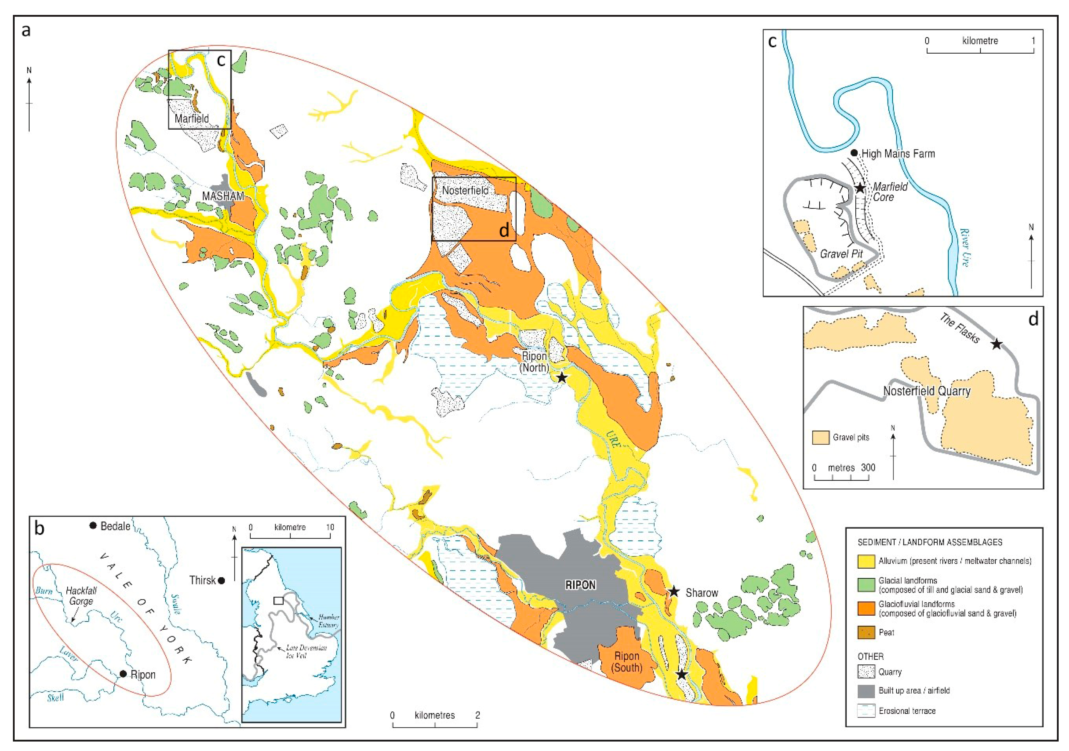
2.1. Study Area: Regional Context and Research Site Setting

2.1.1. The Central Pennines (Yorkshire Dales)

The area of study lies in the Yorkshire Dales, which form the northern part of the Central Pennine hills in northern England. The Central Pennines are composed firstly of sedimentary rocks of Lower Carboniferous limestone, overlain by the Yoredale Series (Wensleydale Group) of limestones, shales and sandstones, and then by the sandstones of the Millstone Grit, bounded to the east by a ridge of Permian Magnesian limestone [19,20], and together form the Askrigg Block. The later, more resistant, sedimentary units form horizontally-bedded strata so that the summits of the upland are mainly flat plateaux areas which support moorland vegetation comprising heath and rough grassland. Only a few hills, with a maximum elevation a little over 700 m, rise above the upland plateaux. The Central Pennines are dissected by several large river valleys, the Dales, which drain the upland to east and west. These are heavily incised in their upper reaches, including the study valley of the River Ure, although form broader, low-gradient valleys at lower altitudes. The relative roles of base-level change and/or uplift are topics of debate regarding this heavy incision and, although this area has been undergoing slow, long-term uplift since pre-Quaternary times [21], it is likely to have been a response to crustal rebound after the removal of last Glacial ice [1]. The glaciation of the Central Pennines has long been recognized [22,23,24], and most or all of the visible evidence can now be attributed to glaciation during the LGM (5). Indeed, there is widespread cover of glacial sediments and the solid geology is rarely exposed, excepting in eroded limestone glaciokarst pavements, eroded spurs such as Kilnsey Crag in Wharfedale [25], rock-cut gorges such as Hackfall Gorge on the Ure [18] or in ‘scars’ on fault lines at the edges of the Askrigg Block, as at its southern border at Giggleswick Scar [26]. Although the Central Pennines probably nurtured local ice accumulation in a few high locations [25,27], it is likely that the upland was over-ridden by ice from major glacial centres to the north and west [5,27]. The rivers of the Yorkshire Dales therefore flow through valleys that have been modified by glaciation [28]. The geomorphology of the Yorkshire Dales is mostly paraglacial [29], and within the valleys are moraines of glacial debris that mark the extent of ice advance or stages in its retreat, and drumlins are common features at all altitudes in the valleys [30,31,32], often streamlined due to ice-stream movement [33], revealing the direction of ice flow. Many other landforms in the Central Pennines indicate the consequences of ice removal, with intense fluvial activity during deglaciation. Rapid river incision into glaciofluvial sands and gravels deposited during deglaciation caused abandoned floodplain surfaces to be preserved as river terraces, often as a series as is well preserved in Upper Wharfdale [34], while meltwater channels, now dry, formed either subglacially or ice marginally as ice retreated into the upland, and are abundant throughout the Yorkshire Dales, but particularly near Ripon. Meltwater also formed esker ridges at ice margins and glacial lakes impounded by morainic material, as at the entrances to the eastern Dales, particularly Wensleydale and Swaledale [18].
While the legacy of deglaciation in the Central Pennines is clear to see in terms of landforms and sediments, the timing of its start and of its various stages is much more difficult to deduce, as erosional landforms and clastic deglacial deposits are difficult to date directly, although promising attempts have been made in Wharfedale [35] with U-series dating. Cosmogenic dates from Stainmore, at the northern edge of the Central Pennines, indicate decoupling of the North Sea Lobe and Stainmore ice prior to ~20 ka, followed by ice recession through the Stainmore Gap by 19.8 ± 0.7 to 18.0 ± 0.5 ka [36]. No organic deposits in the Yorkshire Dales extend back in time to the LGM–Lateglacial transition and the few Lateglacial sites, as at Lunds near the source of the Ure [37] and at Malham Tarn Moss [38] are not radiocarbon dated. The driver for deglaciation in the study area, as elsewhere, was climate and several climate events can be recognized, operating at centennial and millennial scales, superimposed on the tripartite Lateglacial Stadial/Lateglacial Interstadial/Loch Lomond Stadial gross subdivision of the Lateglacial [39,40]. Broadly, the climate changes after the LGM termination at approximately 15 ka 14C BP can be summed up (in radiocarbon years) as five centuries of slow warming, followed by five centuries of significant cooling, then a millennium of gradual warming until 13 ka BP. Abrupt warming then occurred (start of the Interstadial) until 12.4 ka BP followed by a cooling phase until 12 ka BP. Warming then occurred until 11.4 ka BP, followed by a brief cooling phase until 11.2 ka BP, then climate warming from 11.2 to 10.9 ka BP (end of the Interstadial). This was followed by the Loch Lomond Stadial, with a severe cold phase until 10.5 ka BP, and then cold, arid conditions until 10.0 ka BP, after which abrupt warming marked the start of the Holocene. In the study area of the Central Pennines, each of these climate fluctuations would lead to glacier re-advance or retreat during the general process of deglaciation, would govern the fluvial history of the area, and would determine the pattern of erosion and deposition in the Central Pennine valleys. The fluvial geology of a section of the River Ure has been subject to detailed investigation in this regional context.

2.1.2. Geology of the Ure Washlands

The ‘piedmont’ (washland) reaches of the River Ure run across two of the bedrock units mentioned above [18,27,41]. Upstream, to the north-west, lies the sandstones and shales of the Wensleydale Group of the Pennine Carboniferous series, upon which lies the study site at Marfield, just below the point where the course of the Ure was deflected southward by ice blocking its original valley, with the Carboniferous extending downstream to the end of the Hackfall Gorge (Figure 1b). Further south-east are Permian rocks, mainly limestones, which overlie the Carboniferous, the river flowing over these to the end of the study area just south of Ripon (Figure 1). The Hackfall Gorge is the most impressive landscape feature of this section of the Ure valley, and was formed where the deflected early Ure encountered the Permian (Magnesian) escarpment and cut through it, the river incising over 40 m in only a 3 km stretch of valley. Elsewhere in the Ure valley, the bedrock is obscured by a thick cover of superficial sediments, glacial tills (diamicton), sands and gravels, deposited during the last glacial period. These are overlain by the glaciofluvial meltwater sands and gravels laid down during deglaciation, as described above. These form terrace features, with their distribution within the study reach of the Ure valley being shown on Figure 1b. Below the exit of the Hackfall Gorge at Nosterfield is an extensive fan of fluvially-deposited sand and gravel (Figure 1d), formed at the end of the glacial, and a legacy of the severe downcutting that formed the gorge. The second major site in this paper, the Flasks 69, lies upon this fan. The uppermost deposit in the Ure valley is riverine alluvium, present in the current river valley and in abandoned river channels. In places, Lateglacial and Holocene peat deposits rest within and upon the earlier formations. The bedrock and its influence upon deglaciation, has been instrumental in determining the nature of deglaciation, and thereby fluvial history.

2.2. Research Techniques

Geomorphological mapping in the middle Ure valley involved the field survey of 6 to 8 km2 per day, recording the spatial distribution of landforms and superficial deposits and interpreting these in terms of geomorphological processes and their role in landscape evolution [42]. Positive landscape features such as ridges and mounds and negative features including channels and depressions were identified by mapping breaks of slope and plotting these on a 1:25,000 Ordnance Survey topographic map, along with flatter areas that represent fluvial terraces or ancient lake beds. The map provides the basis for a detailed explanation of the geomorphological evolution of the Swale-Ure Washlands [18]. The mapped section relevant to the River Ure between Marfield and Ripon is presented as part of Figure 1, with the distribution of alluvium, glacial and glaciofluvial landforms, peat and the location of quarries shown.
Sediment sequences for lithological and palaeoenvironmental analyses presented in this paper were sampled using a Russian-style corer. Several techniques were used to investigate the sediment profiles in order to reconstruct their development and local environmental conditions. Pollen analysis was employed to allow the reconstruction of vegetation history [43], and to enable a relative age to be assigned to Lateglacial and early Holocene deposits, based upon comparison with other nearby, radiocarbon dated, pollen profiles, e.g., [18,44]. Samples were prepared for pollen analysis using standard techniques [45], using KOH and acetolysis, with HCL and HF in samples with a mineral content. These procedures do not affect the preservation of most non-pollen microfossils such as algal and fungal spores [46]. Pollen residues were stained with safranin, then mounted on microscope slides using silicone fluid. Counts of at least 300 land-pollen grains were made using a standard light microscope at ×400, with pollen nomenclature following Moore et al. [45]. Pollen frequencies were calculated as percentages of a total land-pollen sum, which comprises trees, shrubs and herbs but excludes aquatics and all spores. The pollen diagrams show selected major taxa and taxa groups but exclude those with very low and sporadic counts. Several taxa are combined into groupings based upon their similar life-form and ecology. Of these groupings, ‘tundra/ruderal herbs’ contains Artemisia, Helianthemum, Thalictrum, Chenopodiaceae, Rumex, Saxifraga stellaris-type, Sedum, Silene-type, Taraxacum-type, Plantago maritima and P. lanceolata. ‘Marsh/wetland herbs’ contains Filipendula, Potentilla-type, Cirsium-type, Mentha-type, Ranunculus-type, Stellaria-type and Umbelliferae. ‘Aquatics’ contains the rare records for Myriophyllum alterniflorum, M. spicatum, Nymphaea and Potamogeton. Typha angustifolia and T. latifolia curves are shown separately.
Frequencies of micro-charcoal (particles < 180 μm and thus passing through the sieve used in the preparation schedule) were calculated as percentages of the pollen sum, as described in previous papers [47], as were those of non-pollen palynomorphs (NPPs). These were counted on the pollen slides, identifications made using the catalogue developed at the Hugo de Vries Laboratory, University of Amsterdam [48] and illustrations and descriptions published in various papers [49,50,51,52,53]. One hundred NPPs were counted per level where possible, although at several levels concentration was too low, although counts always exceeded fifty. Established NPP names are used where known, with the catalogue (HdV) code number shown upon first citation. Where NPP names are unknown, the catalogue code number is used throughout. Microfossil diagrams were produced using the TILIA program [54]. Radiocarbon dating [55] was carried out by the Oxford Radiocarbon Accelerator Unit at the University of Oxford using Accelerator Mass Spectrometry (AMS), at the Centre for Isotope Research, Groningen University, Netherlands, and at the Scottish Universities Research and Reactor Centre, East Kilbride. All dates were by Accelerator Mass Spectrometry (AMS). Material for dating was restricted to terrestrial plant macrofossils such as seeds, fruits and bark fragments. Plant roots, aquatic macrofossils and bulk sediment were avoided, with levels chosen for dating decided by the availability of suitable macrofossils. Details of radiocarbon results from the sites mentioned in this paper are shown in Table 1, calibrations being derived using Oxcal 4.2 and IntCal13 [56]. Lithostratigraphy was recorded using the notation devised by Troels-Smith [57], as described by Long et al. [58], and is used in Table 2 and Table 3 as well as descriptions in English.

2.3. Research Sites

Two separate sites were investigated at Marfield: Marfield Quarry (Figure 1 and Figure 2), where gravel outwash sequences were exposed in association with glacial diamicton [59], and the High Mains Channel (Figure 1 and Figure 3, 54°14′26″ N, 1°40′4″ W), a palaeochannel located to the east of the quarry. The channel has been truncated by aggregate extraction, but several hundred metres remain intact. Now more than 10 m above the present river, it would have been an early course of the River Ure, which was abandoned after the river began to incise rapidly through the glaciofluvial deposits that are exposed in the quarry. Together, the two sites at Marfield provide an excellent example of deglacial fluvial history and processes, with ice-marginal outwash sedimentation and the response of a drainage system that has re-established and adjusted its course across the fluvial outwash deposits.
A site was investigated, on the Nosterfield outwash fan (Figure 1) at The Flasks, one of many small drainage channels incised into its surface within which sediment sequences have accumulated since Lateglacial times, as shown by pollen analysis and radiocarbon dating [18,60,61]. These sequences comprise both clastic and organic sediments and represent a long-term record of climatic change since deglaciation. Several of these sediment-filled channels were located during a survey by archaeologists of Mike Griffiths Associates Ltd., and we selected one of them, at core 69 (Figure 1, 54°13′20″ N, 1°33′55″ W), for integrated palaeoenvironmental analyses.
Although microfossil analyses are not presented in this paper, three other sites near to Ripon have been selected to assist the discussion as they have data which are relevant to fluvial history in the later Holocene in that part of the Ure valley, complementing the Lateglacial and early Holocene records at Marfield and The Flasks 69. These sites (Figure 1) are at Sharow Mires (54°8′18″ N, 1°30′14.6″ W), Ripon North (54°11′6.7″ N, 1°32′14″ W) and Ripon South (54°7′0″ N, 1°29′31.5″ W). Their dating results are shown in this paper (Table 1) and their full analyses are available elsewhere [18].

3. Results

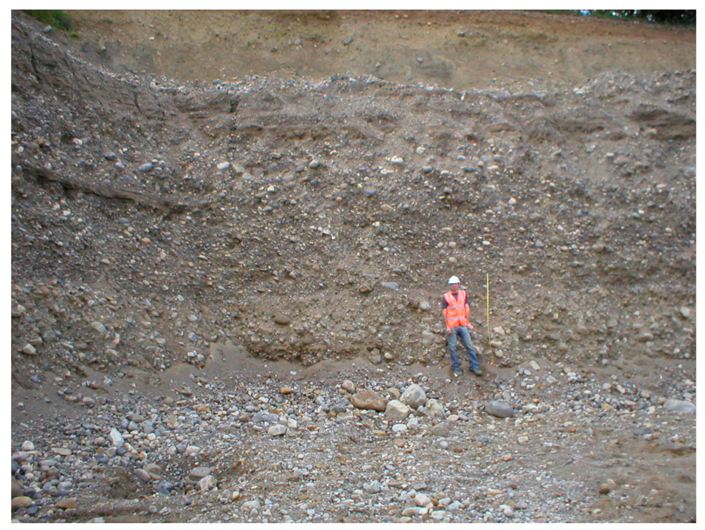
3.1. Marfield Quarry

Moraine ridges at Marfield Quarry are evidence of an oscillating ice margin, probably a lobe associated with the Wensleydale valley glacier that experienced periodic withdrawal and readvance, shown by the thin subglacial till that caps thick sand and gravel outwash sequences exposed in the southeastern part of the quarry (Figure 2). These gravels are excellent examples of ice-marginal deposits [62] and illustrate the power of high-energy meltwater streams in redistributing fine- and coarse-grained clastic material eroded from the ice front. They fine upwards, showing the reducing energy of the fluvial outwash as the ice receded up the valley away from Marfield, before being briefly over-ridden again before final deglaciation. The Marfield Quarry outwash sediments are important, as they allow the fluvial history of this upper part of the Ure Washlands to be reconstructed since deglaciation, and linked to the subsequent fluvial history of sites downstream. They lie 30 m above the present Ure valley floor, and can be regarded as the highest in the sequence of gravel terraces within the river valley which record progressive incision of the river into the outwash deposits. Evidence for this incision at quite an early stage is provided by the High Mains Channel (Figure 3a), which must be an early abandoned channel of the Ure. After the river abandoned its course through this channel, it became filled with later sediments which rest upon the outwash gravels.

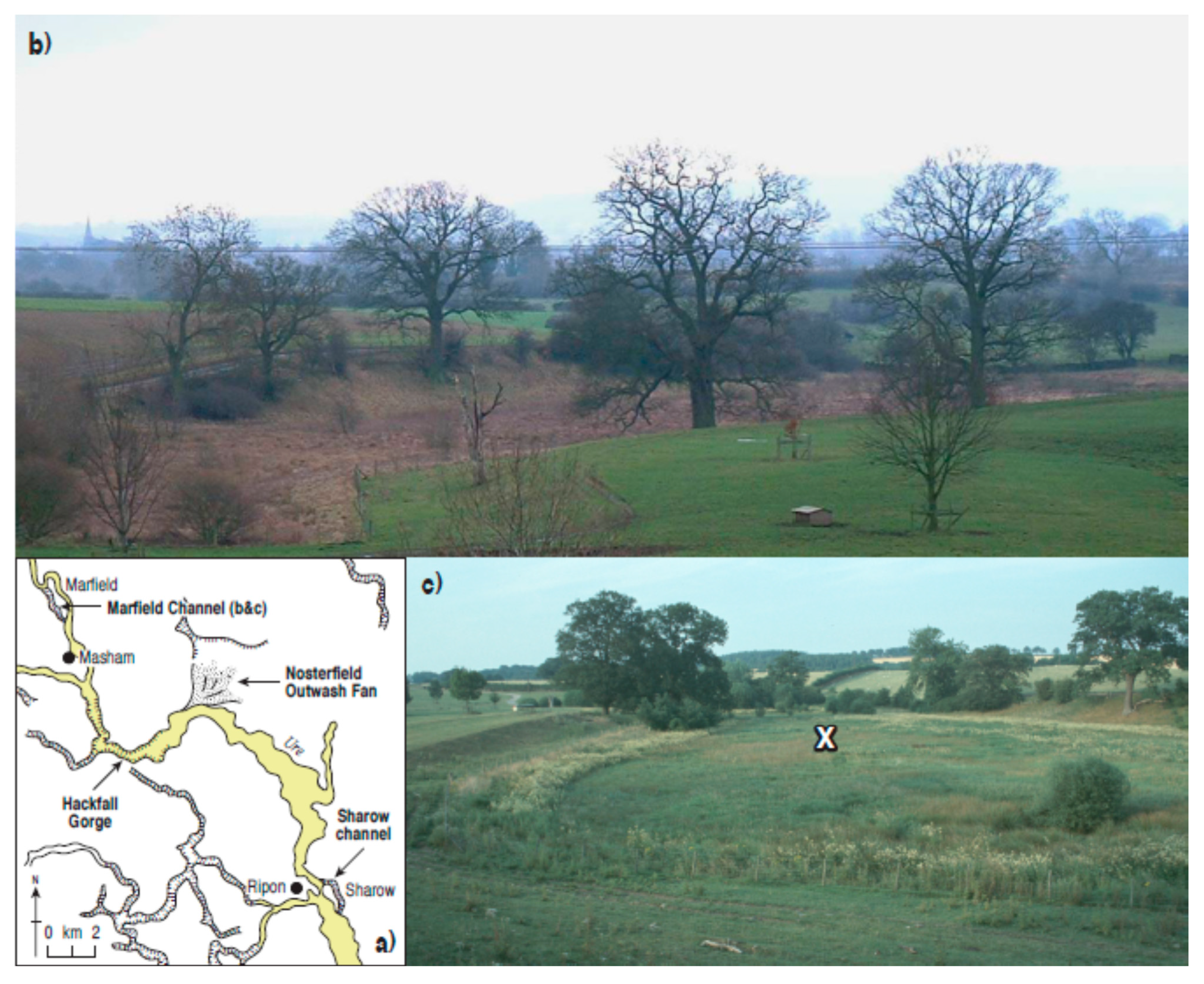
3.2. Marfield High Mains Channel

Cores were obtained of the sedimentary infill of this channel [63], which lies between the quarry and the River Ure at an altitude of approximately 100 m above sea level (Figure 3c). The analysed core was almost 330 cm in depth before encountering a hard surface, probably gravel, which could not be penetrated. The core lithology is shown in Table 2. Most of the sediment comprises shell-rich marls and clayey silts of a kind probably deposited in the open water of a fluvial channel or a pond, which was later confirmed by microfossil analysis. The upper part of the sequence comprised well-humified peat, slightly clayey at intervals, which contained a layer of shell marl. This lithology suggests that the channel was occupied by a water body for most of its history after the river left it and it became a cut-off depression in the landscape.

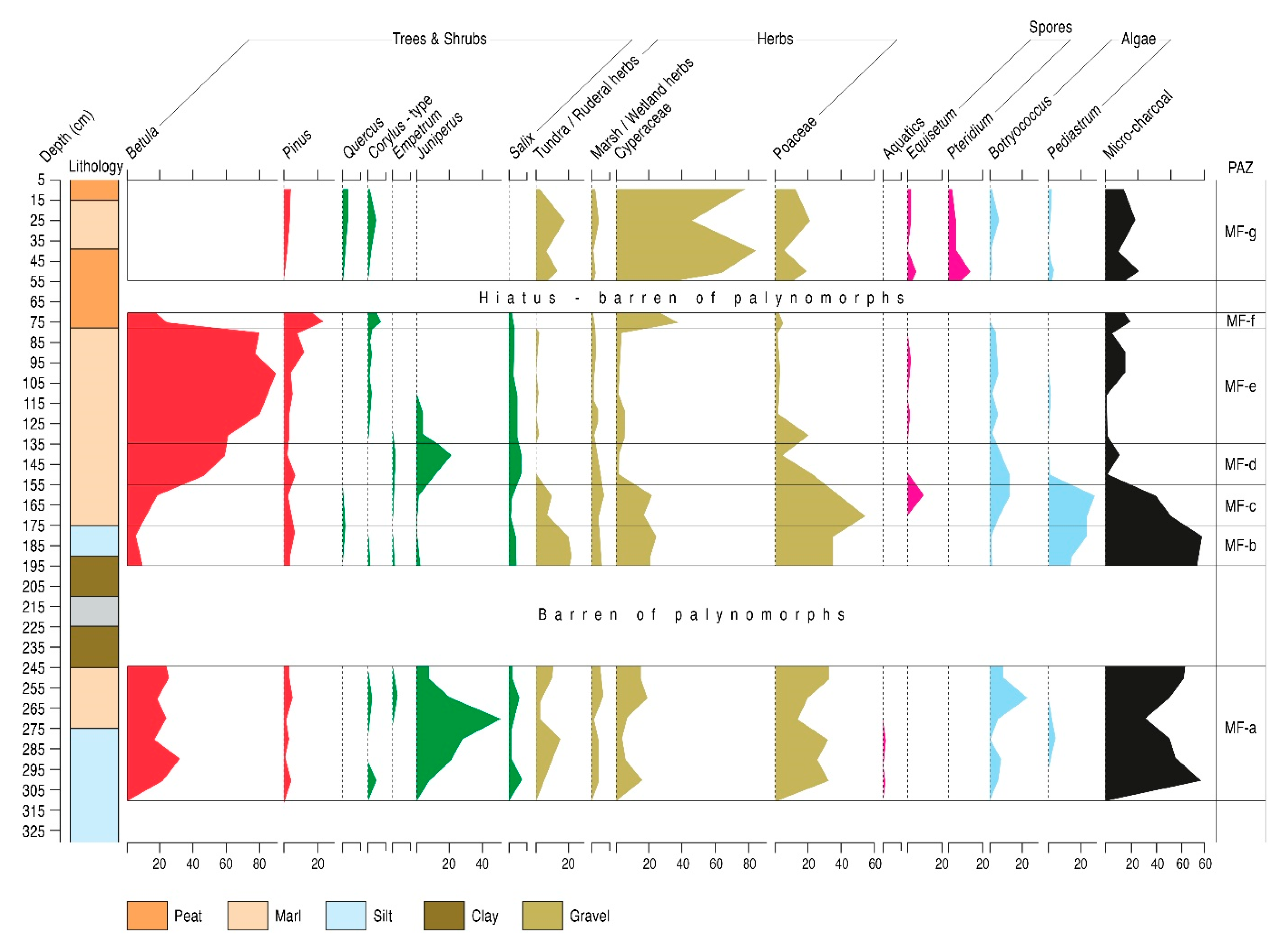
3.2.1. Marfield Channel Palynology

Subsampling for pollen analysis took place at ten-centimetre intervals. Not all levels preserved pollen, with five samples within a stiff lower clayey silt and gravel unit and two samples within the upper peat layer barren of microfossils. Pollen preservation in the counted samples was variable but often poor. Seven pollen assemblage zones (PAZ) have been recognized, with the barren layers excluded from the diagram zonation. A selected-curve diagram is provided in this paper (Figure 4); the full pollen diagram is available elsewhere [60]. The diagram is divided into the following PAZs which include pollen counts at the depths shown.
(1). Zone MF-a: 300, 290, 280, 270, 260 and 250 cm
The zone is characterized by moderate Betula frequencies at approximately 30% of total land pollen (tlp), with shrub pollen represented by Salix and, particularly, Juniperus, which is present throughout and reaches a peak of almost 50% in mid-zone. A small peak of Empetrum occurs late in the zone. Poaceae is the most abundant of the herbaceous taxa, consistently reaching approximately 30%, with lesser frequencies of Cyperaceae, tundra/ruderal herbs and wetland herbs. Artemisia, Helianthemum and Thalictrum are the most prominent of the open ground weeds. The algae Pediastrum (HdV-760) and Botryococcus (HdV-766) are present, particularly the latter. Micro-charcoal counts are high throughout the zone.
(2). Zone MF-b: 190 and 180 cm
Betula frequencies are very low, Juniperus is hardly recorded but Salix levels are similar to the previous zone, as are those for Poaceae and Cyperaceae, although the latter are slightly increased. Tundra/ruderal weeds are significantly increased, comprising mainly Artemisia, Saxifraga stellaris-type and Thalictrum. Marsh/wetland herb percentages change little from the earlier zone. Peaks of Pediastrum occur and micro-charcoal frequencies are high.
(3). Zone MF-c: 170 and 160 cm
This zone is characterized by high Poaceae frequencies, reaching well over 50% of tlp. Cyperaceae percentages are maintained from the previous zone at over 20%. Tundra/ruderal herb frequencies have fallen considerably, and Artemisia has been replaced by Rumex as the main constituent of the group. Betula percentages rise through the zone, although remain moderate. Marsh/wetland herbs change little from their values in earlier zones. Pediastrum values are particularly high at almost 30%, whereas wetland types Botryococcus and Equisetum show lesser peaks. Micro-charcoal frequencies are still significant but decline through the zone.
(4). Zone MF-d: 150 and 140 cm
Tree and shrub pollen dominate the assemblage, with Betula rising through the zone to 60%, Juniperus peaking at 20% and Salix consistent at approximately 10%. Poaceae decline sharply, whereas Cyperaceae and tundra/ruderal herb percentages fall until they are hardly represented. Marsh/wetland herbs remain at the values recorded previously. Botryococcus is still recorded at a little over 10%, but Pediastrum and Equisetum are absent. Micro-charcoal falls to low frequencies.
(5). Zone MF-e: 130, 120, 110, 100, 90 and 80 cm
This zone is dominated almost entirely by Betula, which rises to over 80% of tlp. Juniperus declines sharply and by mid-zone ceases to be recorded. All other taxa and groupings are very poorly represented, although Salix counts are similar to those earlier in the profile. Botryococcus remains present at low values but Pediastrum is virtually absent. Micro-charcoal frequencies are low and intermittent.
(6). Zone MF-f: 75 cm
This single-level zone records a major fall in Betula percentages, while Pinus rises to over 20%, Corylus-type shows a small peak at almost 10%, and Salix values are maintained. Cyperaceae frequencies rise to 50% of tlp, and all other curves are in very low percentages, except micro-charcoal which is in moderate frequencies.
(7). Zone MF-g: 50, 40, 25 and 10 cm
Cyperaceae dominate the assemblage, reaching over 80% of total land pollen. Poaceae and tundra/ruderal herb percentages are moderate at approximately 20%, with Taraxacum-type and Plantago lanceolata prominent in the ruderal assemblage. Pteridium occurs in significant percentages of over 10%. All other pollen taxa are low, including trees and shrubs, with Corylus-type and Quercus present in low frequencies. Equisetum returns to the assemblage, and Botryococcus and Pediastrum still occur, but in low frequencies. Micro-charcoal percentages remain moderate.

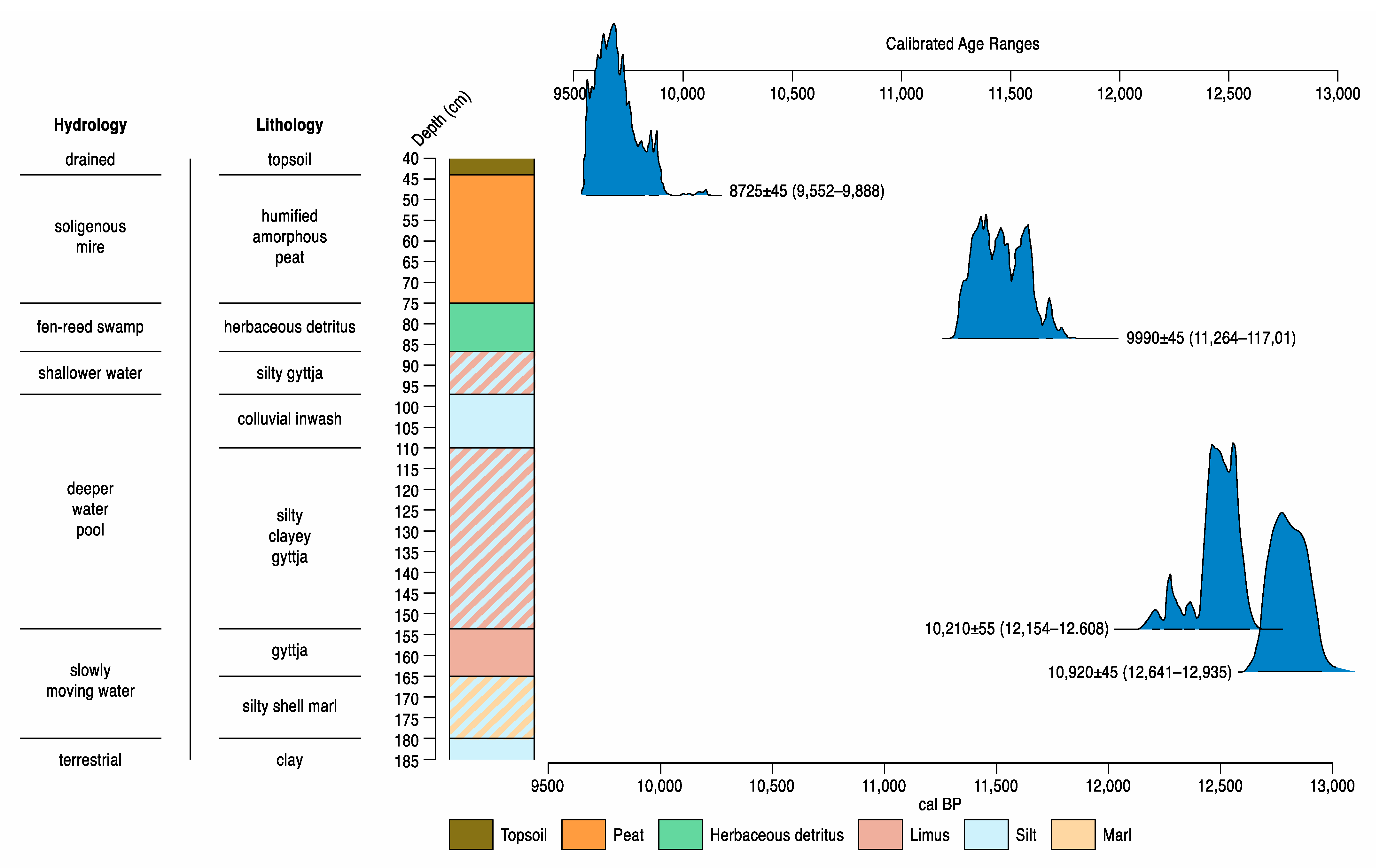
3.2.2. Dating, Hydrology and Environment of Deposition

Unfortunately no suitable terrestrial macrofossils could be recovered from the Marfield core for radiocarbon dating and so the profile has no direct chronological control. Relative dating is possible, however, by comparison of the pollen assemblages with nearby Lateglacial profiles that have been radiocarbon dated, in particular pollen diagrams [18,60] from Mill House at Snape Mires and from the Flasks 69 (see below), both of which have a good series of four dates. The rise of Juniperus to peak values in PAZ MF-a correlates well with a similar period of high Juniperus values at the nearby Mill House 1 profile [60], and suggests that the base of the Marfield diagram can be dated broadly between 12,000 and 11,500 14C years ago, approximately 13,500 calibrated yr BP, during the mid-Lateglacial Interstadial. The clay layer and high Artemisia values in PAZ MF-b point to a Loch Lomond Stadial age, after c. 11,000 14C BP, analogous to that level at both Mill House 1 and the Flasks 69. The succession from MF-c onwards is clearly that of the early Holocene, with initial high Poaceae and Pediastrum, and the beginnings of a rise in Corylus-type pollen in PAZ MF-f suggest a date of approximately 9000 14C BP for that point in the diagram.
The dating of PAZ MF-g, after an apparent hiatus in the profile, is problematic but the lack of woody taxa and dominance of open-ground herbs with sedges and Pteridium points to a date in the late Holocene.
The clay, marl and limnic sediments at Marfield indicate open water deposition within the channel after its abandonment by the river approximately 12,000 14C BP, in the centuries after c. 14,000 cal. BP, which is supported by the presence of Botryococcus algae throughout the profile, suggesting cool, mesotrophic open water [51,64], accompanied by lower values of Pediastrum. The near absence of aquatic pollen throughout the profile might represent the position of the core in the centre of a wide channel, away from the habitat of any aquatic plants at the channel fringes. The presence of shelly marl sediments with Botryococcus in mid-PAZ MF-g indicates continued aquatic deposition, perhaps during a flooding period if the amorphous peats of that upper part of the profile indicate more terrestrial depositional environments within a soligenous mire, in what must equate with the later Holocene.

3.2.3. Vegetation History

The relative dating of the Marfield profile to a period between the middle of the Lateglacial Interstadial and the start of the early Holocene Corylus rise, so c.12,000 to c.9000 14C BP, means that the vegetation changes are typical of that climatically transitional period. PAZ MF-a saw the expansion of Juniperus and Betula woodland, but the high values for Poaceae, Cyperaceae and terrestrial herbs show that these woods remained very open. PAZs MF-b to f record a typical early Holocene succession from tall herb communities through Empetrum and Juniperus scrub to closed canopy Betula woodland. The vegetation of PAZ MF-g, of unknown late Holocene age, was clearly very open. Even if the high Cyperaceae percentages reflect local sedge dominance of the mire surface, the high Pteridium and ruderal herb values and the lack of tree and shrub pollen indicate a deforested landscape, perhaps of quite recent age.

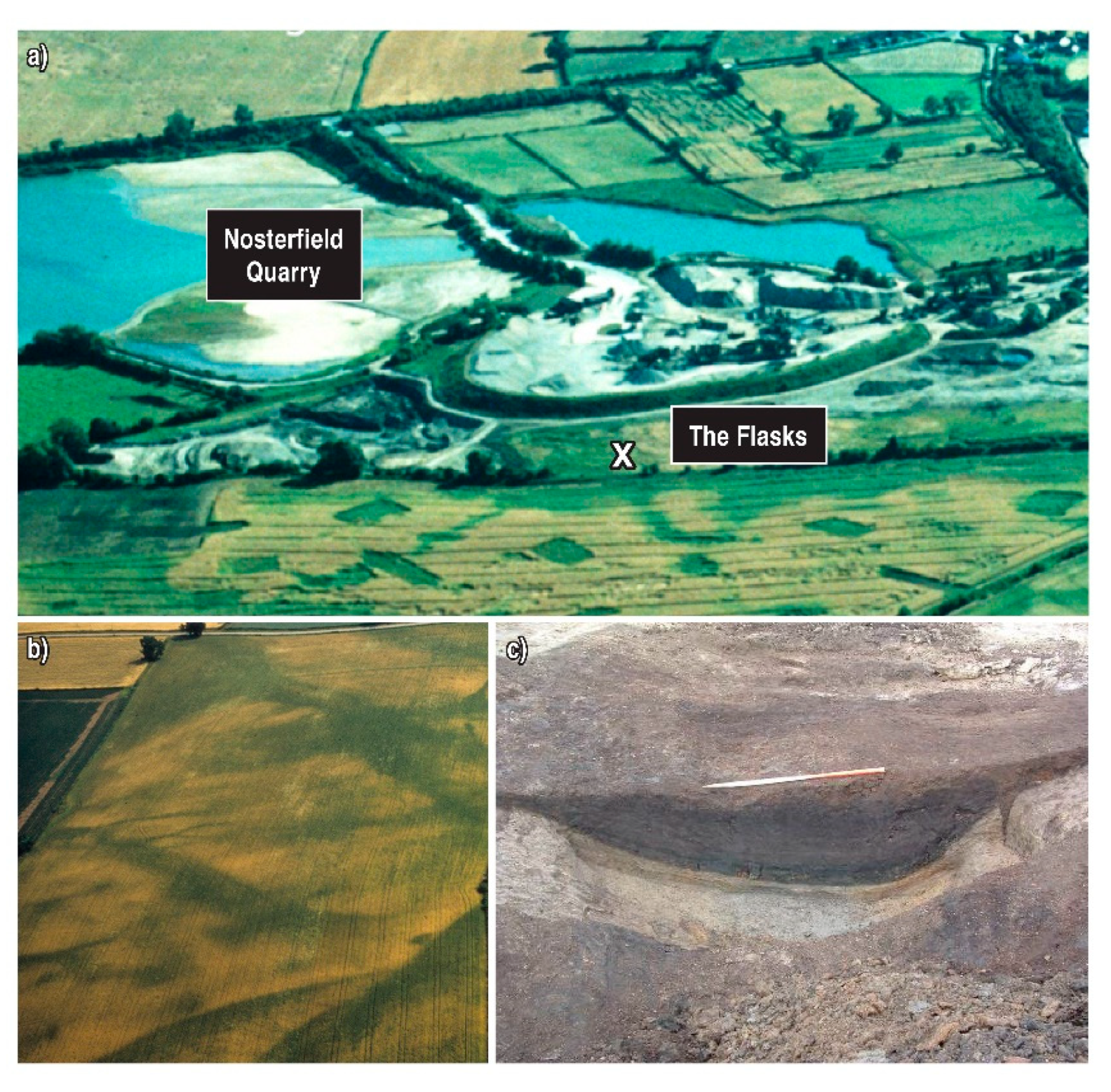
3.3. Nosterfield, the Flasks 69

A core was recovered from this site at Nosterfield Quarry (Figure 5a) which was 235 cm in depth. Here we report on the results of lithostratigraphic and palynological investigations. The core lithology (Table 3) records shelly marl and limnic units separated from an upper detrital and humified peat sequence by a silty clay layer, all resting upon stiff clays and gravel.

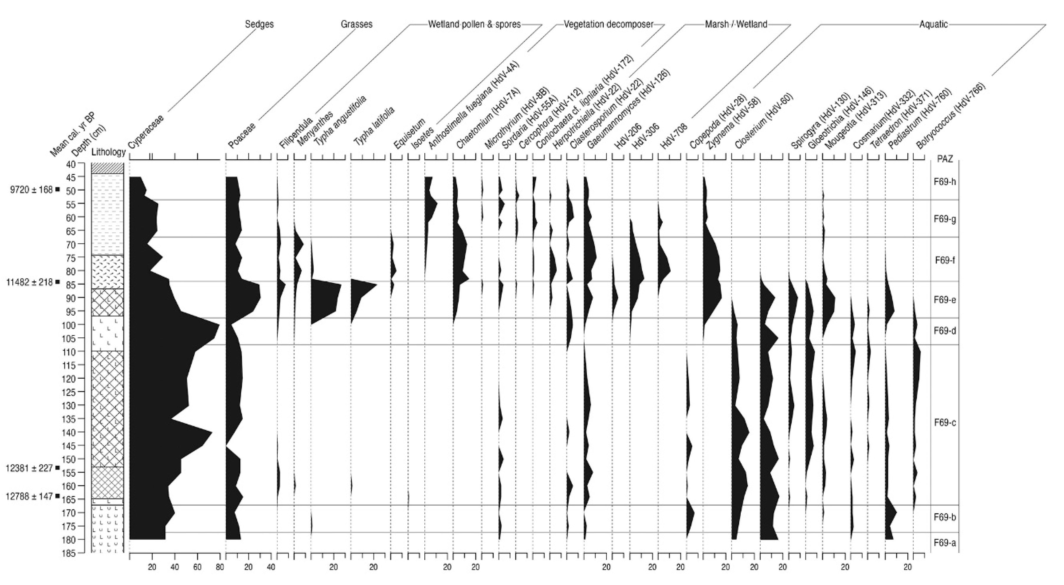
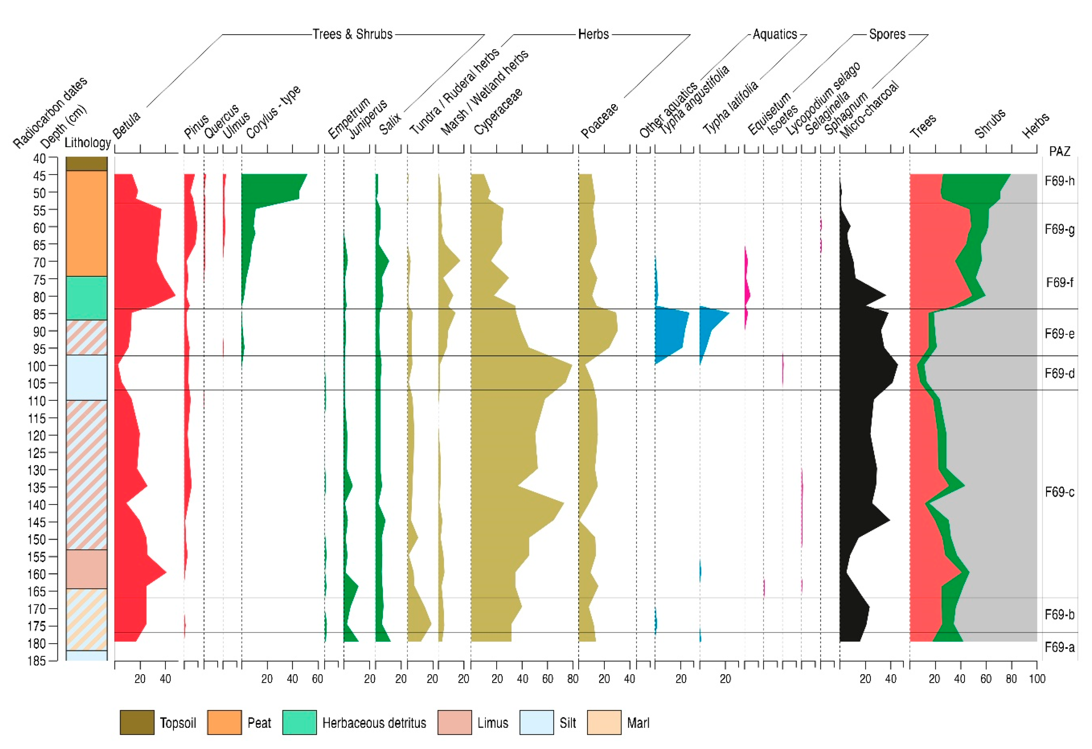
3.3.1. The Flasks 69 Palynology

Subsampling for pollen analysis took place at five-centimetre intervals through the core, and only a few levels did not preserve countable pollen, although preservation was generally only moderate, with a degree of grain corrosion apparent. Sampling at closer intervals occurred in the upper part of the profile, in order to establish pollen zone boundaries more closely and so aid selection of levels for radiocarbon dating. The detailed pollen diagram has been published previously [18,60], so a selected curve diagram is provided here (Figure 6). Eight pollen assemblage zones (PAZs) have been recognized and these have been applied to the NPP diagram from the Flasks 69 (Figure 7), which also shows the main wetland pollen and spore types from Figure 6. The PAZs include pollen counts at the depths shown.
(1). Zone F69-a: 180 cm
In this single-level zone, trees and shrubs account for approximately 40% of tlp, almost entirely comprising Betula, Juniperus and Salix, with Betula most abundant at 20%. Overall Cyperaceae is the most prominent pollen type, at 30%, with Poaceae also important, at approximately half that frequency. Marsh/wetland herbs representation is very low, but the tundra/ruderal herbs group reaches 10%. Micro-charcoal frequencies are moderate.
Few NPPs are recorded, all algal spores, and in low frequencies. Type HdV-128 occurs at almost 20% of tlp, while Pediastrum and Closterium (HdV-60) are present in lower frequencies.
(2). Zone F69-b: 170 and 175 cm
Betula percentages increase slightly and both Juniperus and Salix are reduced. Empetrum occurs for the first time. Cyperaceae and Poaceae values are little changed, except that the former increases slightly at the expense of the latter. Tundra/ruderal herb frequencies increase significantly, caused mainly by a rise in Artemisia, and there is a greater diversity of taxa, with Helianthemum, Plantago maritima and Rumex joining the assemblage. The marsh/wetland herbs curve remains very low. Very few other taxa are recorded, although there are isolated grains of the aquatic Typha angustifolia. Micro-charcoal values remain moderate at a little over 20%.
Amongst the NPPs, HdV-128, Pediastrum and Closterium are still the most abundant taxa, but also present in low frequencies are Cosmarium (HdV-332) and Copepoda (HdV-28).
(3). Zone F69-c: 164, 160, 155, 150, 145, 140, 135, 130, 120 and 110 cm
In this zone, Betula frequencies fluctuate but are consistently approximately 20% of tlp. Salix percentages remain steady at approximately 10% but Juniperus declines to very low values. Pinus becomes better represented in the latter half of the zone. The assemblage is dominated by Cyperaceae, which is consistently above 40%, with Poaceae much lower, at less than half that figure. Both tundra/ruderal and marsh/wetland herbs are much reduced, the latter to very low percentages, mainly represented by Filipendula, while the former maintains low values between 5 and 10%. All other pollen types are hardly present. Micro-charcoal percentages rise in the later part of the zone to a consistent 30%.
HdV-128 and Closterium are still major components of the NPP assemblage, with frequencies initially consistent at almost 20%, although declining late in the zone. The algal assemblage is more diverse, however, with Gloeotrichia (HdV-146) now present and becoming increasingly important in the upper zone, as is Botryococcus, with Spirogyra (HdV-130), Mougeotia (HdV-313) and Tetraedron (HdV-371) joining the assemblage. Pediastrum is consistently present, but in low frequencies. Peaks of Copepoda occur. Taxa that are marshland rather than open-water aquatic also occur, including Gaeumannomyces (HdV-126), Clasterosporium caricinum (HdV-25) and Sordaria (HdV-55A).
(4). Zone F69-d: 105 and 100 cm
Betula values fall sharply while most other taxa remain unchanged, except for Cyperaceae which rises to approach 80%, dominating the zone. Poaceae values decline significantly, while marsh/wetland herbs are almost absent. Micro-charcoal frequencies rise to almost 50%.
Although proportions of individual taxa fluctuate, the NPP assemblage constituents are very similar to those of the previous zone. Clasterosporium caricinum is more prominent and Botryococcus less so, but overall there is little change.
(5). Zone F69-e: 95, 90 and 85 cm
Betula frequencies recover but remain low, with other trees and shrubs, notably Pinus, Juniperus and Salix, consistently present in very low percentages and Corylus-type, Ulmus and Quercus appear. Cyperaceae decline but are still abundant, at approximately 40%, whereas Poaceae recovers to account for more than 30% of tlp. Tundra/ruderal herbs maintain their values, while marsh/wetland herbs increase significantly to more than 15%, mainly contributed by Filipendula. Both Typha angustifolia and T. latifolia occur in high values (>20%). Micro-charcoal frequencies remain high at 40%.
The NPP assemblage becomes much more diverse in this zone, and while aquatic/open water algae remain important, all decline late in the zone, with some taxa of that group fading from the assemblage, notably Closterium and Botryococcus. Pediastrum and Mougeotia values rise sharply, and there is the appearance and rise to high frequencies of new taxa, including Zygnema (HdV-58), Herpotrichiella (HdV-22), HdV-206, HdV-306, and Chaetomium (HdV-7A).
(6). Zone F69-f: 83, 80, 75 and 70 cm
Betula percentages increase to approximately 40%, with Salix percentages also increasing, to approximately 10%. Corylus-type percentages rise steadily though the zone and Juniperus and Pinus are consistently present. There are sporadic records of Quercus and Ulmus. Total tree and shrub pollen percentages rise sharply from 20% to 65% of the total pollen sum. Cyperaceae and Poaceae percentages are both reduced, to approximately 30% and 20%, respectively. Tundra/ruderal herbs are almost absent, but marsh/wetland herbs maintain high values, reaching almost 20%. Frequencies of Typha sp. are greatly reduced, but T. angustifolia is still recorded and other aquatics, including Menyanthes, enter the record. A consistent low Equisetum curve occurs. Micro-charcoal values decline through the zone, to only 10%.
Many open water NPPs are no longer recorded, notably HdV-128, Gloeotrichia, Spirogyra and Pediastrum. Marsh/wetland taxa Zygnema, HdV-306, Chaetomium, and Herpotrichiella increase and HdV-708 enters the assemblage in high values. Anthostomella fuegiana (HdV-4A) is recorded for the first time.
(7). Zone F69-g: 65, 62, 60 and 55 cm
In this zone, Betula frequencies remain at approximately 40%, while Pinus and Corylus types are steady at 10%. Quercus and Ulmus increase but remain at low frequencies, Salix declines and Juniperus disappears. Cyperaceae and Poaceae percentages change little, together representing c. 35% of the total pollen sum. The diversity of the herb pollen assemblage decreases greatly, with tundra/ruderal herbs virtually absent and marsh/wetland frequencies very low. Aquatics and Equisetum are no longer recorded. Micro-charcoal values are low.
Types HdV-708, HdV-306, Herpotrichiella, Chaetomium and Zygnema percentages decline sharply, while Anthostomella fuegiana, Sordaria and Clasterosporium caricinum all increase. Cercophora (HdV-112) and Coniochaeta cf. ligniaria (HdV-172) are important for the first time.
(8). Zone F69-h: 52, 50 and 45 cm.
Corylus-type dominates the assemblage of this final zone, at over 50% of tlp. Betula falls to 20% while the other tree and shrub types maintain their values. Cyperaceae and Poaceae percentages are low, together constituting approximately 20%, with few other herbs recorded. Micro-charcoal records are negligible.
NPP percentages are generally low in this final zone, with Anthostomella fuegiana, Chaetomium, Gaeumannomyces and Zygnema the only taxa showing significant frequencies. Many aquatic and marsh taxa are no longer recorded.

3.3.2. Dating, Hydrology and Environment of Deposition

Four dates are available from the Flasks 69 sequence, forming a good chronological series (Table 1; Figure 7 and Figure 8). The earliest dates, from within the lower limnic unit, show that deposition commenced (Table 4) in the Lateglacial Interstadial [39,65,66], which is represented by PAZs F69-a to c. The later, stratigraphically higher dates show that the start of the Holocene can be located in PAZ F69-e, so that the clastic clay-silt of PAZ F69-d represents deposition during the severe cold of the Loch Lomond Stadial, cf. Greenland Stadial GS-1 [40,67], which terminates the Lateglacial sequence. The changes in stratigraphic units and fluctuations between clastic and organic deposits recorded in the Flasks 69 core indicate climate oscillations between colder and warmer climate during the transition from Lateglacial to Holocene interglacial conditions. The lithology is illustrated and described in Figure 8, which also interprets the stratigraphy in terms of environments of deposition. The presence of marls, gyttjas and detrital organic material in the sediment column points to deposition within a water body, which survey showed was of small size. There is little to confirm this in the Lateglacial pollen assemblage (Figure 6), where aquatics are almost absent, perhaps because of the cold water and low biological productivity, nor to suggest the type of water body involved. The major peaks of Typha, particularly T. latifolia, and the rise of a suite of marsh and wetland herbs in PAZ F69-e, however, confirm the presence of open water, albeit undergoing rapid terrestrialisation in the early Holocene.
While the pollen says little regarding the nature of the Flasks 69 water body in the Lateglacial, however, the NPP data have provided new insights. The presence of Closterium indicates cold open water [68] as does HdV-128, likely to be Volvocaceae algae [69], which prefers slowly moving, open water and is common in Lateglacial contexts [70,71]. This suggests that a shallow channel, rather than an enclosed pond, is a more plausible interpretation of the Flasks 69 feature, which was probably one of the many small, narrow palaeochannels that are visible across the Nosterfield fan on aerial photographs (Figure 5b). Excavated examples of these (Figure 5c) have displayed tripartite sediment fills similar to that recorded in the Flasks 69 profile. The rest of the Lateglacial Interstadial, before the cold phase of PAZ F69-d, still records open water, but the greater diversity of algae suggests a mesotrophic environment, more organic sedimentation and the start of the colonisation of the channel fringes by shallow-water marsh plants, with Clasterosporium caricinum and Gaeumannomyces growing upon Carex species in those habitats [49,70,72]. Carex species were clearly very important in the Loch Lomond Stadial in both terrestrial and aquatic fringe environments, forming sedge-marsh communities. Pioneer algal taxa such as Gloeotrichia, Tetraedron and Cosmarium [68,71,72,73] are early colonisers that increase the trophic status of the water and improve conditions for later plant and algal hydroseral succession. Although still open, the rise in Gloeotrichia suggests that the water in the channel was clear and was becoming shallower from this stage onwards [74].
Holocene depositional environments (Figure 8) from PAZ F69-e onwards reflect continuing terrestrialisation of the channel, passing through shallow-water, reedswamp and fen stages, perhaps with some Salix carr, culminating in a soligenous mire. Marsh and wetland herbs characterize the earlier stages of this hydrosere, with Equisetum and Typha, and the NPP record matches this succession closely, with Herpotrichiella, Mougeotia, HdV-306, HdV-708, Chaetomium and Zygnema typical of shallow water mesotrophic reedswamp to fen environments [51,68,75,76,77]. Pediastrum colonies, preferring shallow, eutrophic water and warmer conditions [78,79] are common in this earlier transitional aquatic environment, although some Pediastrum, probably species tolerant of colder conditions [80], consistently occurred in low numbers throughout the cooler Lateglacial phases. The change to amorphous peat in the upper part of the profile (Figure 8) suggests full terrestrialisation of the channel surface and conversion to marshy soligenous mire communities, and the almost complete lack of fully aquatic taxa of any kind supports this. Records of Anthostomella fuegiana, Sordaria and Coniochaeta cf. ligniaria in the upper two PAZs indicate that the mire surface was occupied by grasses and sedges, perhaps including Eriophorum, indicating a more acidic peat [51], perhaps fringed with woody taxa.

3.3.3. Vegetation History
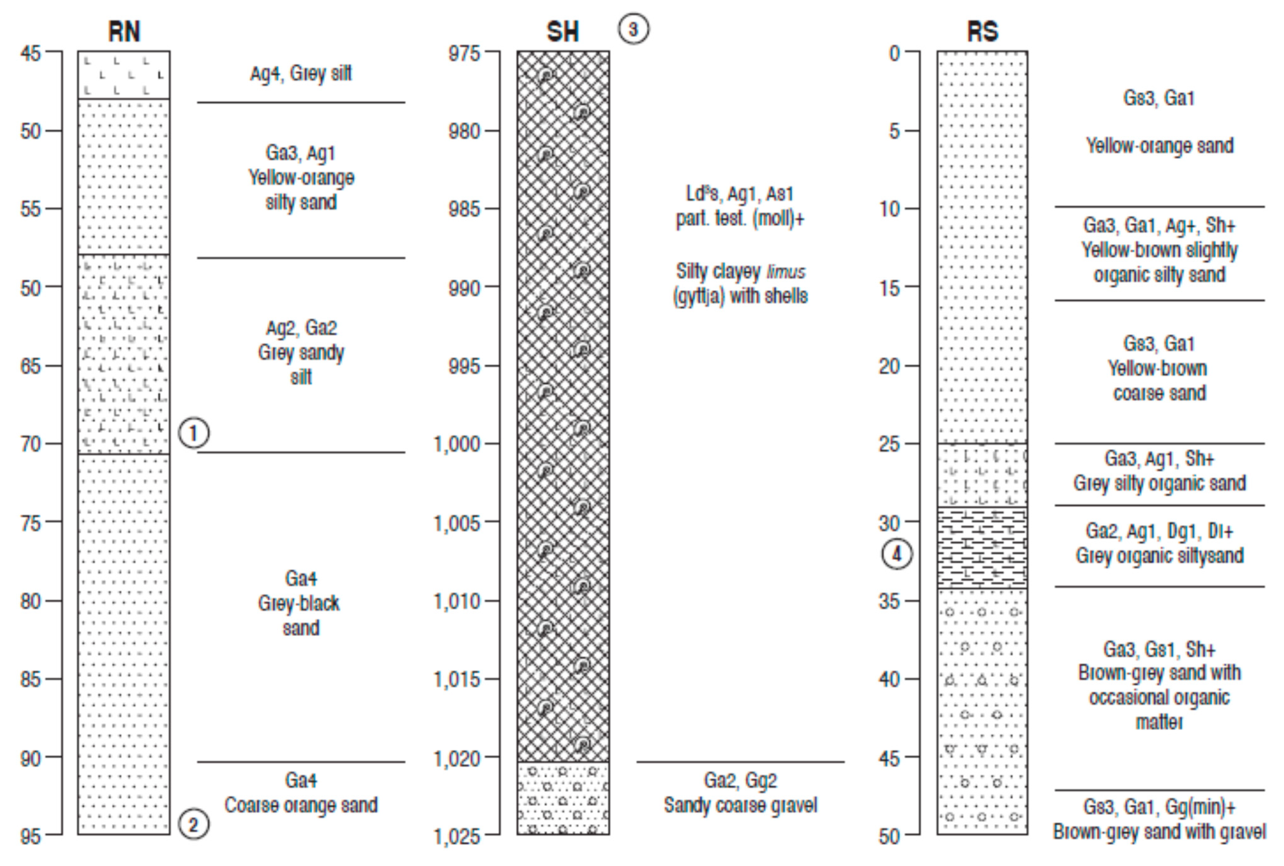
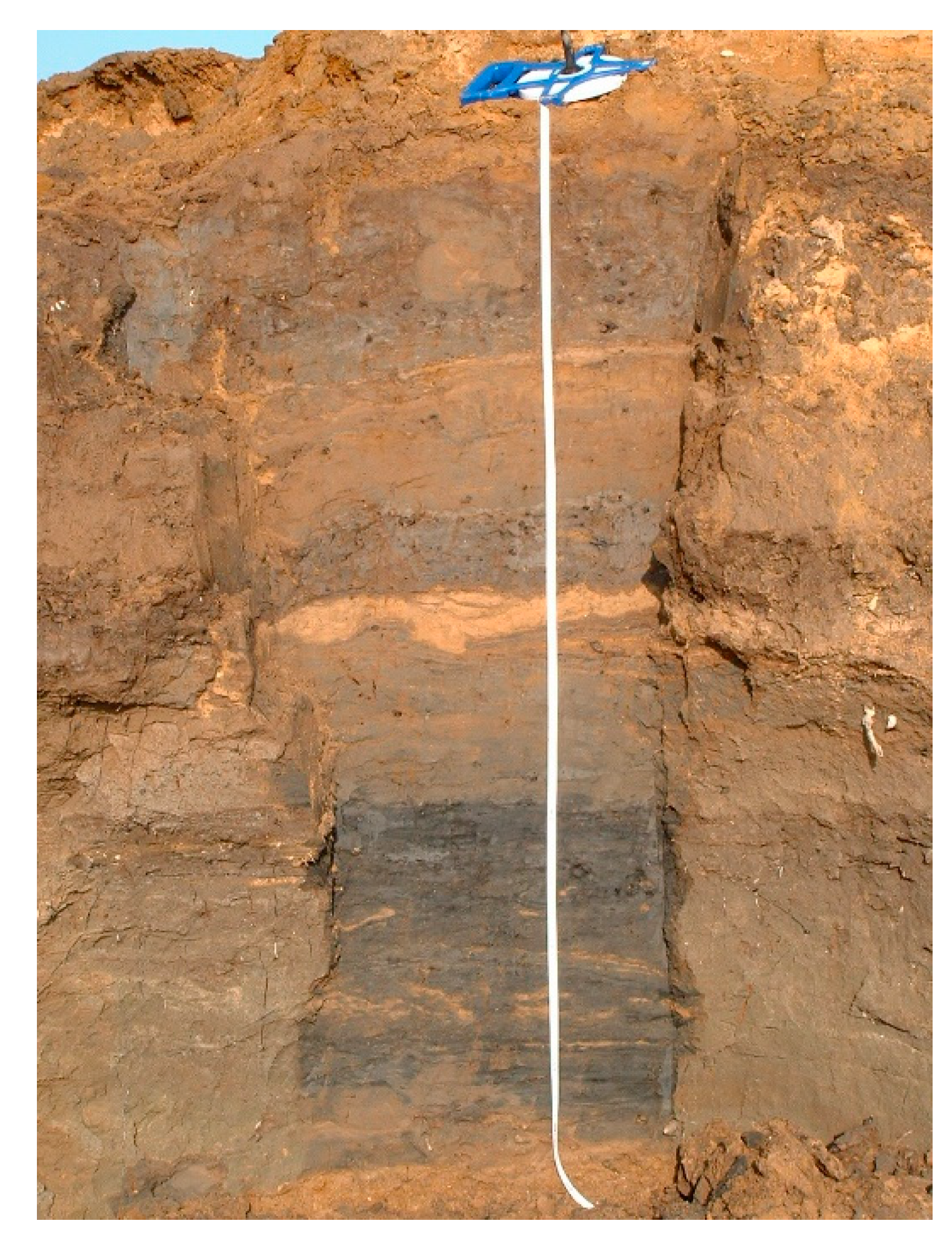
The tripartite stratigraphy comprising a limnic unit separated from a detrital and humified upper peat sequence by a thick clay layer suggests deposition during the Lateglacial period, with Interstadial organic lake muds laid down under temperate-climate conditions and covered by inorganic inwashed clay during the severe cold of the Lateglacial (Loch Lomond) Stadial, before deposition of peats in a renewed temperate, Holocene, climate. The pollen record shown in Figure 6 supports this, and agrees well with the radiocarbon dating, dates being close to the expected ages for the pollen features [81,82] that were selected for dating. Very open Betula and Salix woodland became established during deposition of the two organic units, but with considerable sedge- and grass-covered open ground. Sedge–tundra open herbaceous vegetation was dominant in the intervening cold phase, then climatic amelioration allowed increased biological productivity in the wetland and terrestrial plant succession at the start of the Holocene and the transition to a more wooded landscape. Juniperus scrub was shaded out by Betula woods, which were in turn replaced by Corylus, creating a closed canopy woodland ground cover.

3.4. Other Sites

This section briefly discusses dating and lithostratigraphy at sites around Ripon [18], at the downstream end of the Washland reach of the River Ure (Figure 1). Palynological data are not presented here, as the pollen record at these sites cannot be used for the relative dating of their basal deposits, other than all being post-Ulmus-decline [82,83] and so later than approximately 5000 14C BP (c. 5800 cal. BP). This is too late in the Holocene for any diagnostic pollen assemblage change [82] that carries a chronological signature, other than the terminus post quem of 5000 14C BP. Their ages of formation rely on radiocarbon dating of organic facies as low in the profile as possible, given the radiocarbon methodology constraints outlined in the methods section, so that their age determinations will be approximate. The lower lithologies of these three sites are shown in Figure 9, and are from an abandoned river channel at Sharow Mires (SH), and alluvial sequences at Ripon North (RN) and at a lower, short section at Ripon South (RS), the earliest at that site. All three profiles rest upon sandy gravel. At Sharow Mires, five metres of silty organic sediment overlies the gravel and is capped by another five metres of silty clay, and represents a fluvial channel infill which silted up after abandonment. Ripon North is a quarry exposure, where an organic, silty, fine-grained alluvial palaeochannel infill rests upon fluvial terrace gravels. Ripon South is also a quarry exposure, where an alluvial channel fill comprising silty sandy sediments with silty organic layers overlies shelly sandy terrace gravel. The alluvial sediments exposed in an upper, later section at Ripon South are illustrated in Figure 10.
Ripon North is furthest upstream (Figure 1) and the top of the basal gravel is at approximately 27 m a.s.l. The next site downstream is Sharow Mires, where the top of the basal gravel is at approximately 17 m a.s.l., whereas the altitude of the basal gravels at the most southerly site, Ripon South, is at approximately 16 m a.s.l. The estimated ages of the lowest dateable levels at Sharow Mires and Ripon South (Figure 9) are similar, although with wide calibrated age ranges (Table 1), and the base of the channel fill can be interpolated to between approximately 4200 and 4700 cal. BP. The age of the formation of Ripon North is more difficult to estimate, but is likely to be in the centuries after c.5800 cal. BP (post-Ulmus decline), and so earlier than the two downstream sites, as would be expected from its greater altitude; the relation of this group of sites within the terrace sequence of the Ure is illustrated in Figure 11. Although the dating of the formation of these three channels in the downstream reach of the washland Ure is very imprecise, they are clearly much later than channel formation in the Nosterfield and Marfield areas (Table 4). It is possible that the abandonment of river channels and renewed incision in the Ripon area between 4500 and 4000 cal. BP may be a response to climatic deterioration and increased rainfall, as recorded as wet shifts in bog profiles in northern England [85] during Holocene Event 3 and the transition to the Neoglacial in the North Atlantic region [86,87]. Increased anthropogenic forest clearance in the Pennines around Wensleydale at this time (the start of the Bronze Age) [88,89,90,91] could also have provided increased catchment water runoff, with climate change also encouraging river instability, flooding, incision, and channel alluviation at this time [92,93,94].

4. Discussion

4.1. Lateglacial and Early Holocene Vegetation History

The combined vegetation history from Marfield and the Flasks 69 is an important contribution to the Lateglacial and early Holocene vegetation history of Wensleydale and the North Yorkshire Pennines in general. It needs to be considered in some detail as the relative dating at Marfield depends upon it and the dating sequence at the Flasks 69 is confirmed by it. The pollen data from these two profiles are similar to the Lateglacial and early Holocene record from other sites in the local region, at Dishforth Bog [95], Bingley Bog [96], Bedale [97] and Tadcaster [98], and particularly the nearby sites within Snape Mires, only five km to the north and east [18,60]. The vegetation history at both Marfield and the Flasks 69 extends back to the temperate Lateglacial Interstadial, although the sequence at the latter site begins between 500 and 1000 years later, reflecting the relative ages of the two channel features. At both sites Betula frequencies are similar, at approximately 30% of tlp during the middle of this temperate climate phase. Open woodland, probably of a parkland type, was becoming established as temperatures recovered after the brief mid-Interstadial cold event (Greenland GI1-d) [40,99] at approximately 13,850 cal. BP, which is recorded at nearby Mill House [60], at Bingley Bog [96] and at Tadcaster [98]. The lack of a pollen signature of this cold event in the Marfield pollen diagram suggests that the date of the Marfield channel abandonment was probably after that date. The high Juniperus frequencies at Marfield are typical of the northern part of North Yorkshire, seen in all the local diagrams [81], and its absence at the Flasks 69 reflects the later date of the start of pollen deposition at that site, after the main Juniperus maximum was over. For the rest of the Lateglacial, the two diagrams conform to the general pattern of vegetation change, with the partially wooded conditions of the later part of the Interstadial, although the Betula woodland was much better developed at Marfield than at the Flasks 69. This was probably because of the more stable soil conditions at Marfield, and more akin to Mill House [60], soil profiles having had longer to become established at both these sites than on the surface of the more-recently deposited and less sheltered Nosterfield gravel fan. At all regional sites, this succession to woodland was interrupted by the severe cold of the Loch Lomond Stadial and vegetation reversion to a Poaceae- and Cyperaceae-dominated sedge-tundra, with Cyperaceae frequencies at both Mill House and the Flasks 69 reaching 80% of tlp, and Artemisia prominent.
Notable at all these sites are the high frequencies of micro-charcoal throughout the Lateglacial and particularly in the Loch Lomond Stadial. Upper Palaeolithic (Lateglacial) flints have been found in Wensleydale [100] as well as in Pennine caves [101], indicating that hunter-gatherers were present in these Pennine-flank valleys and in North Yorkshire generally during this period. It is possible that the microscopic charcoal particles originate from human burning of vegetation and from campfires. However, as the burning seems to have been ubiquitous, continuous and quite intensive, a natural origin is more likely, as the Lateglacial, and particularly the Loch Lomond Stadial, was climatically arid [39,40], and micro-charcoal frequencies fall sharply in the record from the early Holocene, when there were more people active in the area, but climate was wetter. Whatever the cause, these two sites are further examples of Lateglacial sequences rich in micro-charcoal, a widespread phenomenon [102]. The vegetation successions of the early Holocene are similar at both study sites, with tall herb communities followed by Juniperus, Betula and Corylus-type pollen maxima and the establishment of post-glacial woodland. The Marfield Betula peak reaches 80%, similar to those at Bingley Bog and Tadcaster, as full Betula woodland was established, although at the Flasks 69 it reached only half of that, probably due to continuing unstable soil conditions on the Nosterfield gravel fan. In contrast, the Corylus-type peak is pronounced at the Flasks 69, but less so at Marfield, being truncated by hiatus there, so that more stable soils had become established on the Nosterfield fan by then. Overall, the data from these two middle Ure pollen sites are representative of the early Holocene vegetation succession that is recorded at all the neighbouring North Yorkshire pollen diagrams, with the radiocarbon dates at the Flasks 69 exactly as would be expected for these early Holocene vegetation changes [82].

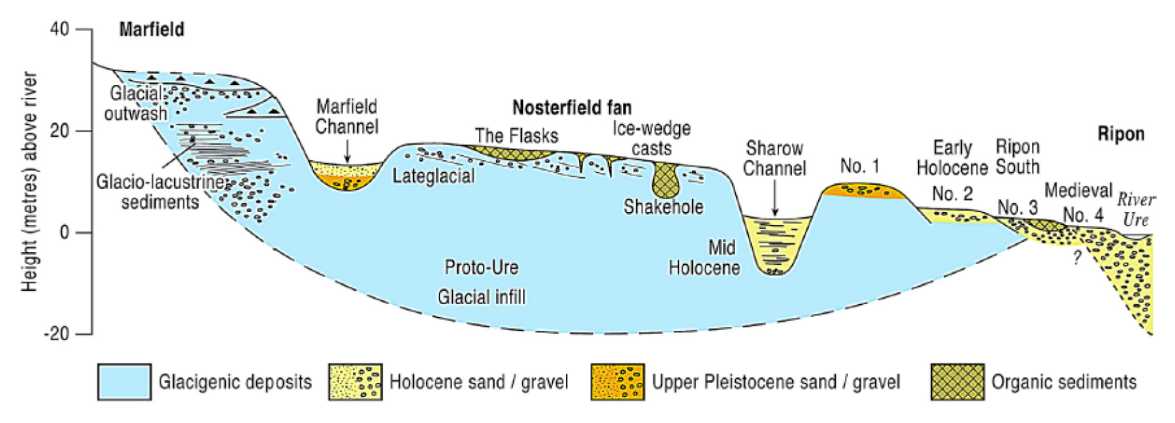
4.2. Relict Fluvial Features—Terraces and Channels

The features that are most representative of the Ure system in its middle reaches are its highly complex series of relict terraces and channels. Many were carved by subglacial and ice-marginal meltwater during deglaciation [7] but others are evidence of course changes of the river and its tributary streams during the Lateglacial and Holocene, and of the processes driving terrace formation and fluvial channel abandonment. Such palaeochannels are a feature of all the river valleys of the eastern Pennines [103,104] and have been mapped in the Swale and the Wharfe as well as the Ure [18,34,105]. They occur in considerable numbers and formed at all stages of the Lateglacial and the Holocene, as rivers adjusted their courses in response to rapid incision due to isostatic (atectonic) uplift [106,107] and heavy sedimentation loads, particularly after major flood events caused by climate fluctuations and human impacts in the catchment [82,93,94,108]. This is well illustrated in the Ure drainage, with some relict river channels mapped at even higher altitudes, and therefore presumed to be older, than the Marfield channel, an example being the 5 km in length Thieves Gill feature [18,109] which lies at approximately 120 m above sea level, 20 metres higher than the High Mains sequence. Radiocarbon dating and palynology of as close to basal sediments as possible in these channels have provided in each case a terminus ante quem for their creation, probably by river avulsion. Combined with their altitude above sea level, this information has allowed a reconstruction of fluvial history, particularly terrace formation and incision, in the middle Ure valley, and an exemplar for fluvial research in deglaciated terrain.

4.3. Wider Comparisons

This multi-disciplinary investigation of the fluvial archives of the mid-altitude Ure valley provides a valuable case study of fluvial activity and environmental change since deglaciation in an upland river system, and the findings invite comparison with research in similar contexts elsewhere in the British Isles and beyond. The Ure results conform to the general paradigm of climate-controlled fluvial evolution [110,111] with initial paraglacial high-energy braided rivers dominated by gravel deposition, followed by sandur-type outwash sediment distribution and then entrenchment and terrace formation, before settling into floodplains with migrating river courses and channel abandonment [112,113,114,115,116]. Fluvial regimes and the pattern of sedimentation and erosion in the Ure are similar to those recorded in the foothills of the hills of northern England as a whole, where considerable previous research exists. Most analogous to the Ure research has been the study of lengthy reaches of the Ribble Valley and its tributaries, on the western side of the Pennines [117,118,119], which has also combined geomorphological mapping of glacial and fluvial features, geochronology and palaeoenvironmental analyses. Similar multi-discipline records occur in the valleys draining the northern uplands in the Isle of Man, where fluvial incision into valleys full of deglaciation gravels led to the formation of terraces and alluvial fans at valley mouths between 15,000 and 10,500 years ago [120,121]. The similar geomorphological and fluvial deglaciation histories in these uplands are a product of the high availability of mostly coarse-grained sediment and the adjustment of rivers to the new high-energy drainage regime. Holocene records from these other fluvial archives also correspond with the Ure evidence, in that little fluvial activity occurs in the mid-Holocene but renewed incision and alluviation occurs in the later Holocene (Table 4). Climatic factors are likely to be responsible for this similarity, with human destabilisation of catchments probably also an influence [82,90,122,123,124].
The suite of incisions, fills and palaeochannels that are present in the Ure valley, and in those of the other rivers of northern England mentioned above, are also characteristic of fluvial evolution in the river valleys of northern mainland Europe which experienced major climate shifts during the Lateglacial and transition to the Holocene. Syntheses of data from long reaches of valley are necessary for understanding these fluvial systems, and have been accomplished in Poland in the Vistula and Warta [110,125], both much larger rivers than the Ure. In both cases braided channels existed during the Lateglacial and meandering channels in the Holocene, and many abandoned palaeochannels have been investigated using palynology and radiocarbon dating, with a full range of examples from the late LGM through to the very late Holocene. Long-term fluvial dynamics have also been studied in the valleys of several large German rivers [126], as well as the Maas in the Netherlands [125,127] and in Poland and Spain [128], and, again, fluvial sedimentary units have been shown to correlate closely with climate changes on a continent-wide scale. As with the Ure, fluvial activity decreased markedly in the mid-Holocene, with high levels of activity in the Lateglacial and the late Holocene. The landforms and sediments found in these large North European rivers are closely analogous to the evidence from the much smaller River Ure described in this paper, and show that the processes and drivers that have governed fluvial evolution since deglaciation have operated irrespective of spatial scale and river size.

5. Conclusions

This study of the middle Ure valley shows that a multi-disciplinary approach, combining field mapping with lithostratigraphic and palaeoenvironmental analyses, can be used to reconstruct an integrated fluvial history that explains the genesis and evolution of both landforms and sedimentary facies. Such integration of research techniques is a strategy that is likely to prove valuable in a wide range of research contexts and locations. Microfossil analyses of sedimentary infills, allied to radiocarbon dating, have provided detailed information regarding the ages and environments of deposition of an altitudinal staircase of terraces, interspersed with erosional features, and so provide an understanding of the rate of incision and distribution of river channels in a deglaciated landscape. This understanding allows the fluvial history to be linked to external forces, mainly tectonic/atectonic uplift, climatic or human activity, which have driven fluvial changes during periods of stability and instability in the river catchment. North Yorkshire has proved to be an ideal field laboratory for this methodology, with its combination of upland and lowland glaciation in the Devensian. Repeated ice advance and retreat across a relatively small area created a complex mosaic of surficial, glacially-derived sediments and landforms, upon which were imprinted a suite of ice-marginal erosional and depositional fluvial features, providing excellent examples of riverine processes in deglaciated terrain.

Author Contributions

Conceptualisation, investigation and methodology, D.B. and D.R.; data production, J.I., C.O. and M.R.; field geology mapping, W.M.; writing, J.I., D.B., W.M. and M.R.; project administration, D.B. All authors have read and agreed to the published version of the manuscript.

Funding

This research was funded by the Aggregates Levy Sustainability Fund (ALSF), which was established by the UK government to raise funds to mitigate the environmental impact of aggregates extraction. This project was entitled ‘The Late Quaternary Landscape Evolution of the Swale-Ure Washlands, North Yorkshire’.

Institutional Review Board Statement

Not applicable.

Informed Consent Statement

Not applicable.

Data Availability Statement

Not applicable.

Acknowledgments

We are grateful to Chris Orton of the Cartographic Unit, Geography Department, Durham University for producing the figures and to Peter Marshall for undertaking the dating program. We thank Mike Griffiths & Associates for assistance with the fieldwork and providing survey information, and landowners for access to the sites, in particular Lafarge Aggregates Ltd. for Marfield and Tarmac for Nosterfield. We are grateful to Professor Antony Long for helping to design this project and acquire the funding, and to English Heritage for administering this project. We thank the anonymous reviewers for their helpful comments.

Conflicts of Interest

The authors declare no conflict of interest.

References

  1. Bridgland, D.R.; Westaway, R. The use of fluvial archives in reconstructing landscape evolution: The value of sedimentary and morphostratigraphic evidence. Neth. J. Geosci. Geolog. Mijnbouw. 2012, 91, 5–24. [Google Scholar] [CrossRef]
  2. Cordier, S.; Briany, B.; Bridgland, D.R.; Herget, J.; Maddy, D.; Mather, A.; Vandenberghe, J. The fluvial archives group: 20 years of research connecting fluvial geomorphology and paleoenvironments. Quat. Sci. Rev. 2017, 166, 1–9. [Google Scholar] [CrossRef] [Green Version]
  3. Wilson, L.J.; Austin, W.E.N.; Jansen, E. The last British Ice Sheet: Growth, maximum extent and deglaciation. Polar Res. 2002, 21, 243–250. [Google Scholar] [CrossRef] [Green Version]
  4. Clark, C.D.; Evans, D.J.A.; Khatwa, A.; Bradwell, T.; Jordan, C.J.; Marsh, S.H.; Mitchell, W.A.; Bateman, M.D. Map and GIS database of glacial landforms and features related to the last British Ice Sheet. Boreas 2004, 33, 359–375. [Google Scholar] [CrossRef] [Green Version]
  5. Evans, D.J.A.; Clark, C.D.; Mitchell, W.A. The last British Ice sheet: A review of the evidence utilised in the compilation of the glacial map of Britain. Earth Sci. Rev. 2005, 70, 253–312. [Google Scholar]
  6. Mitchell, W.A.; Innes, J.B.; Bridgland, D.R.; Long, A.J.; Rutherford, M.M.; Warwick, S. Landscape evolution of the Swale–Ure Washlands. In Yorkshire Landscapes Past and Present; Atherden, M., Milsom, T., Eds.; PLACE Research Centre: York, UK, 2008; pp. 77–87. [Google Scholar]
  7. Mitchell, W.A.; Bridgland, D.R.; Innes, J.B. Late Quaternary evolution of the Tees-Swale interfluve east of the Pennines: The role of glaciation in the development of river systems in northern England. Proc. Geol. Assoc. 2010, 121, 410–422. [Google Scholar] [CrossRef]
  8. Best, J.L.; Bristow, C.S. Braided Rivers; Geological Society of London, Special Publication 75: London, UK, 1993. [Google Scholar]
  9. Giles, J.R.A. The Sand and Gravel Resources of the Country around Bedale, North Yorkshire. Description of 1:25000 Sheet SE28; Institute of Geological Sciences Mineral Assessment Report 119; HMSO: London, UK, 1982. [Google Scholar]
  10. Cooper, A.H. The Geology of the Country North and East of Ripon, North Yorkshire with Particular Reference to the Sand and Gravel Resources; Description of 1:25,000 Sheet SE 37; Institute of Geological Sciences: London, UK, 1983. [Google Scholar]
  11. Strong, G.E.; Giles, J.R.A. The Sand and Gravel Resources of the Country around West Tanfield, North Yorkshire; Description of 1:25,000 Resource Sheet SE 27; Institute of Geological Sciences Mineral Assessment Report 135; HMSO: London, UK, 1983. [Google Scholar]
  12. Morigi, A.N.; James, J.W.C. The Sand and Gravel Resources of the Area Northeast of Ripon, North Yorkshire; Description of 1:25,000 Resource Sheet SE 37 and Part of SE 47; Institute of Geological Sciences Mineral Assessment Report 143; HMSO: London, UK, 1984. [Google Scholar]
  13. Taylor, M.P.; Macklin, M.G.; Hudson-Edwards, K. River sedimentation and fluvial response to Holocene environmental change in the Yorkshire Ouse Basin, northern England. Holocene 2000, 10, 201–212. [Google Scholar] [CrossRef]
  14. Brown, A.G. Aggregate-related archaeology in England in a changing environment. In Geoarchaeology, Climate Change, and Sustainability; Brown, A.G., Basell, L.S., Butzer, K.W., Eds.; Special Paper 476; Geological Society of America: Boulder, CO, USA, 2011; pp. 183–194. [Google Scholar]
  15. Ward, I. The contribution of English Heritage Aggregates Levy Sustainability Fund research to geoarchaeology and sustainability. In Geoarchaeology, Climate Change, and Sustainability; Brown, A.G., Basell, L.S., Butzer, K.W., Eds.; Special Paper 476; Geological Society of America: Boulder, CO, USA, 2011; pp. 173–182. [Google Scholar]
  16. Bridgland, D.R.; Long, A.J. Late Quaternary Landscape Evolution of the Swale–Ure Washlands. Available online: https://archaeologydataservice.ac.uk/archives/view/swaleure_eh_2008/ (accessed on 1 February 2021).
  17. Johnson, P.G. Evidence for abandoned river courses in the west of the Vale of York. Proc. Yorkshire Geol. Soc. 1974, 40, 223–232. [Google Scholar] [CrossRef]
  18. Bridgland, D.R.; Innes, J.B.; Long, A.J.; Mitchell, W.A. Late Quaternary Landscape Evolution of the Swale–Ure Washlands; Oxbow Books: Oxford, UK, 2011. [Google Scholar]
  19. Rayner, D.H.; Hemingway, J.E. The Geology and Mineral Resources of Yorkshire; Yorkshire Geological Society: Leeds, UK, 1974. [Google Scholar]
  20. Aitkenhead, N.; Barclay, W.J.; Brandon, A.; Chadwick, R.A.; Chisholm, J.I.; Cooper, A.H.; Johnson, E.W. British Regional Geology: The Pennines and Adjacent Areas, 4th ed.; HMSO/British Geological Survey: Nottingham, UK, 2002. [Google Scholar]
  21. Westaway, R. Quaternary uplift of Northern England. Glob. Planet. Chang. 2009, 68, 357–382. [Google Scholar] [CrossRef]
  22. Raistrick, A. The glaciation of Wensleydale, Swaledale and the adjoining parts of the Pennines. Proc. Yorkshire Geol. Soc. 1926, 20, 366–410. [Google Scholar] [CrossRef]
  23. Raistrick, A. Periodicity of glacial retreat in West Yorkshire. Proc. Yorkshire Geol. Soc. 1927, 21, 24–29. [Google Scholar] [CrossRef]
  24. Raistrick, A. The correlation of retreat stages across the Pennines. Proc. Yorkshire Geol. Soc. 1932, 22, 199–214. [Google Scholar] [CrossRef]
  25. Howard, A.J.; Macklin, M.G. Introduction to the Eastern Yorkshire Dales. In The Quaternary of the Eastern Yorkshire Dales. Field Guide; Howard, A.J., Macklin, M.G., Eds.; Quaternary Research Association: London, UK, 1998; pp. 1–4. [Google Scholar]
  26. Huddart, D. Gigglewick Scar (SD 803 655). In Quaternary of Northern England; Geological Conservation Review Vol. 25; Huddart, D., Glasser, N.F., Eds.; Joint Nature Conservation Committee: Peterborough, UK, 2002; pp. 203–208. [Google Scholar]
  27. Atkinson, K. Glacial history. In Historical Atlas of North Yorkshire; Butlin, R.A., Ed.; Westbury: Otley, UK, 2003; pp. 10–13. [Google Scholar]
  28. Penny, L.F. Quaternary. In Geology and Mineral Resources of Yorkshire; Rayner, D.H., Hemingway, J.E., Eds.; Yorkshire Geological Society: Leeds, UK, 1974; pp. 254–264. [Google Scholar]
  29. Ballantyne, C.K. Paraglacial geomorphology. Quat. Sci. Rev. 2002, 21, 1935–2017. [Google Scholar] [CrossRef]
  30. Mitchell, W.A. Western Pennines Field Guide; Quaternary Research Association: London, UK, 1991. [Google Scholar]
  31. Mitchell, W.A. Drumlins in ice-sheet reconstruction with special reference to the Western Pennines. Sediment. Geol. 1994, 91, 313–331. [Google Scholar] [CrossRef]
  32. Mitchell, W.A. Reconstructions of the Late Devensian (Dimlington Stadial) British-Irish Ice Sheet: The role of the upper Tees drumlin field, northern Pennines, England. Proc. Yorkshire Geol. Soc. 2007, 56, 221–234. [Google Scholar] [CrossRef]
  33. Stokes, C.R.; Clark, C.D. Geomorphological criteria for identifying Pleistocene ice streams. Ann. Glaciol. 1999, 28, 67–74. [Google Scholar] [CrossRef] [Green Version]
  34. Howard, A.J.; Macklin, M.G.; Black, S.; Hudson-Edwards, K. Holocene river development and environmental change in upper Wharfedale, Yorkshire Dales, England. J. Quat. Sci. 2000, 15, 239–252. [Google Scholar] [CrossRef]
  35. Black, S.; Howard, A.J.; Macklin, M.G. U-series dating of cemented river gravels and tufa deposits in Upper Wharfedale, between Kettlewell and Grassington. In The Quaternary of the Eastern Yorkshire Dales. Field Guide; Howard, A.J., Macklin, M.G., Eds.; Quaternary Research Association: London, UK, 1998; pp. 31–44. [Google Scholar]
  36. Davies, B.J.; Livingstone, S.J.; Roberts, D.H.; Evans, D.J.A.; Gheorghiu, D.M.; Ó Cofaigh, C. Dynamic ice stream retreat in the central sector of the last British-Irish Ice Sheet. Quat. Sci. Rev. 2019, 225, 105989. [Google Scholar] [CrossRef]
  37. Walker, D. Late-glacial deposits at Lunds, Yorkshire. New Phytol. 1955, 54, 343–349. [Google Scholar] [CrossRef]
  38. Pigott, C.D.; Pigott, M.E. Late-glacial and post-glacial deposits at Malham, Yorkshire. New Phytol. 1963, 62, 317–334. [Google Scholar] [CrossRef]
  39. Walker, M.J.C.; Coope, G.R.; Lowe, J.J. The Devensian (Weichselian) Lateglacial palaeoenvironmental record from Gransmoor, East Yorkshire, England. Quat. Sci. Rev. 1993, 12, 659–680. [Google Scholar] [CrossRef]
  40. Mayle, F.E.; Bell, M.; Birks, H.H.; Brooks, S.J.; Coope, G.R.; Lowe, J.J.; Sheldrick, C.; Li, S.; Turney, C.S.M.; Walker, M.J.C. Climate variations in Britain during the last Glacial-Holocene transition (15.0–11.5 cal. ka BP): Comparison with the GRIP ice-core record. J. Geol. Soc. Lond. 1999, 156, 411–423. [Google Scholar] [CrossRef]
  41. Cooper, A.H.; Burgess, I.C. Geology of the Country around Harrogate (Sheet 62); HMSO: London, UK, 1993. [Google Scholar]
  42. Evans, D.J.A. Glacial Landsystems; Arnold: London, UK, 2004. [Google Scholar]
  43. Godwin, H. History of the British Flora, 2nd ed.; Cambridge University Press: Cambridge, UK, 1975. [Google Scholar]
  44. Hibbert, F.A.; Switsur, V.R.; West, R.G. Radiocarbon dating of Flandrian pollen zones at Red Moss, Lancashire. Proc. R. Soc. Lond. B 1971, 177, 161–176. [Google Scholar]
  45. Moore, P.D.; Webb, J.A.; Collinson, M.E. Pollen Analysis, 2nd ed.; Blackwell: Oxford, UK, 1991. [Google Scholar]
  46. Clarke, C. Differential recovery of fungal and algal palynomorphs versus embryophyte pollen and spores by three processing techniques. In Aspects of Archaeological Palynology: Methodology and Applications; Davis, O.K., Ed.; Contributions Series 29; AASP: Houston, TX, USA, 1994; pp. 53–62. [Google Scholar]
  47. Innes, J.B.; Simmons, I.G. Mid Holocene charcoal stratigraphy, fire history and palaeoecology at North Gill, North York Moors, UK. Palaeogeogr. Palaeoclimatol. Palaeoecol. 2000, 164, 151–161. [Google Scholar] [CrossRef]
  48. van Hoeve, M.L.; Hendrikse, M. A Study of Non-Pollen Objects in Pollen Slides. The Types as Described by Dr. Bas van Geel and Colleagues; Unpubulished; Universiy of Utrecht: Utrecht, The Netherlands, 1998. [Google Scholar]
  49. Van Geel, B. A palaeoecological study of Holocene peat bog sections in Germany and the Netherlands. Rev. Palaeobot. Palynol. 1978, 25, 1–120. [Google Scholar] [CrossRef]
  50. Van Geel, B. Application of fungal and algal remains and other microfossils in palynological analyses. In Handbook of Palaeoecology and Palaeohydrology; Berglund, B.E., Ed.; John Wiley: Chichester, UK, 1986; pp. 497–505. [Google Scholar]
  51. Van Geel, B. Non-pollen palynomorphs. In Tracking Environmental Change Using Lake Sediments, Terrestrial, Algal and Siliceous Indicators; Smol, J.P., Birks, H.J.B., Last, W.M., Eds.; Kluwer: Dordrecht, The Netherlands, 2001; Volume 3, pp. 99–119. [Google Scholar]
  52. Miola, A. Tools for non-pollen palynomorphs (NPPs) analysis: A list of Quaternary NPP types and reference literature in English language (1972–2011). Rev. Palaeobot. Palynol. 2012, 186, 142–161. [Google Scholar] [CrossRef]
  53. Shumilovskikh, L.S.; van Geel, B. Non-pollen palynomorphs. In Handbook for the Analysis of Micro-Particles in Archaeological Sediments; Henry, A.G., Ed.; Springer: Cham, Switzerland, 2020; pp. 65–94. [Google Scholar]
  54. Grimm, E.C. TGView v.2.0.2, Software; Illinois State Museum, Research and Collections Centre: Springfield, IL, USA, 2004. [Google Scholar]
  55. Marshall, P.; Bayliss, A.; Meadows, J.; Bronk Ramsey, C.; Cook, G.; van der Plicht, H. Appendix I. Radiocarbon Dating. In Late Quaternary Landscape Evolution of the Swale–Ure Washlands; Oxbow Books: Oxford, UK, 2011. [Google Scholar]
  56. Reimer, P.J.; Bard, E.; Bayliss, A.; Beck, J.W.; Blackwell, P.G.; Bronk Ramsey, C.; Buck, C.E.; Cheng, H.; Edwards, R.L.; Friedrich, M.; et al. IntCal13 and Marine13 radiocarbon age calibration curves 0–50,000 Years cal. BP. Radiocarbon 2013, 55, 1869–1887. [Google Scholar] [CrossRef] [Green Version]
  57. Troels-Smith, J. Karakterisaring af Lose Jordarter (Characterization of Unconsolidated Sediments). Danm. Geol. Undersøg. 1955, 3, 1–73. [Google Scholar]
  58. Long, A.J.; Innes, J.B.; Shennan, I.; Tooley, M.J. Coastal stratigraphy: A case study from Johns River, Washington. In The Description and Analysis of Quaternary Stratigraphic Field Sections. Technical Guide 7; Jones, A.P., Tucker, M.E., Hart, J.K., Eds.; Quaternary Research Association: London, UK, 1999; pp. 267–286. [Google Scholar]
  59. Roberts, D.H.; Mitchell, W.A.; Bridgland, D.R.; Innes, J.B. Marfield Quarry. In The Quaternary of Northumberland, Durham and North Yorkshire. Field Guide; Davies, B.J., Yorke, L., Bridgland, D.R., Roberts, D.H., Eds.; Quaternary Research Association: London, UK, 2013; pp. 143–149. [Google Scholar]
  60. Innes, J.B.; Rutherford, M.M.; O’Brien, C.E.; Bridgland, D.R.; Mitchell, W.A.; Long, A.J. Late Devensian environments in the Vale of Mowbray, North Yorkshire, UK. Proc. Geol. Assoc. 2009, 120, 199–208. [Google Scholar] [CrossRef]
  61. Tipping, R.M. Nosterfield, North Yorkshire. Report on the Completion of C14 Dating for Sediments from F44, F45, F36 and FIND 14: Recommendations and Proposals for Further Work; Department of Environmental Science, University of Stirling, Mike Griffiths & Associates: York, UK, 2000. [Google Scholar]
  62. Roberts, D.H.; Evans, D.J.A.; Lodwick, J.; Cox, N.J. The sub-glacial and ice-marginal signature of the North Sea Lobe of the British-Irish ice sheet during the last glacial maximum at Upgang, North Yorkshire, UK. Proc. Geol. Assoc. 2013, 124, 503–519. [Google Scholar] [CrossRef]
  63. Innes, J.B.; Rutherford, M.M.; White, T.S.; Bridgland, D.R. The Marfield channel sequence. In The Quaternary of Northumberland, Durham and North Yorkshire. Field Guide; Davies, B.J., Yorke, L., Bridgland, D.R., Roberts, D.H., Eds.; Quaternary Research Association: London, UK, 2013; pp. 149–152. [Google Scholar]
  64. Batten, D.J.; Grenfell, H.R. Botryococcus. In Palynology and Stratigraphy; Jansonius, J., McGregor, D.C., Eds.; American Association of Stratigraphic Palynologists Foundation: New York, NY, USA, 1996; Volume 1, pp. 205–214. [Google Scholar]
  65. Lowe, J.J.; Ammann, B.; Birks, H.H.; Björk, S.; Coope, G.R.; Cwynar, L.; de Beaulieu, J.-L.; Mott, R.J.; Peteet, D.M.; Walker, M.J.C. Climatic changes in areas adjacent to the North Atlantic during the last glacial-interglacial transition (14–9 ka BP): A contribution to IGCP-253. J. Quat. Sci. 1994, 9, 185–198. [Google Scholar] [CrossRef]
  66. Lowe, J.J.; Birks, H.H.; Brooks, S.J.; Coope, G.R.; Harkness, D.D.; Mayle, F.E.; Sheldrick, C.; Turney, C.S.M.; Walker, M.J.C. The chronology of palaeoenvironmental change during the Last Glacial–Holocene transition: Towards an event stratigraphy for the British Isles. J. Geol. Soc. Lond. 1999, 156, 397–410. [Google Scholar] [CrossRef]
  67. Walker, M.J.C. Quaternary Dating Methods; Wiley: Chichester, UK, 2005. [Google Scholar]
  68. van Geel, B.; Bohncke, S.J.P.; Dee, H. A palaeoecological study of an upper Late Glacial and Holocene sequence from “De Borchert”, The Netherlands. Rev. Palaeobot. Palynol. 1981, 31, 367–448. [Google Scholar] [CrossRef]
  69. Joannin, S.; Vannière, B.; Gallop, D.; Peyron, O.; Haas, J.N.; Gilli, A.; Chapron, R.; Wirth, S.B.; Anselmetti, F.; Desmet, M.; et al. Climate and vegetation changes during the Lateglacial and early-middle Holocene at Lake Ledro (southern Alps, Italy). Clim. Past 2013, 9, 913–933. [Google Scholar] [CrossRef] [Green Version]
  70. Pals, J.P.; van Geel, B.; Delfos, A. Paleoecological studies in the Klokkeweel bog near Hoogkarspel (Noord Holland). Rev. Palaeobot. Palynol. 1980, 30, 371–418. [Google Scholar] [CrossRef]
  71. van Geel, B.; Coope, G.R.; van der Hammen, T. Palaeoecology and stratigraphy of the Late-glacial type section at Usselo (The Netherlands). Rev. Palaeobot. Palynol. 1989, 60, 25–129. [Google Scholar] [CrossRef]
  72. van der Wiel, A.M. A palaeoecological study of a section from the foot of the Hazendonk (Zuid-Holland, The Netherlands), based on the analysis of pollen, spores and macroscopic plant remains. Rev. Palaeobot. Palynol. 1983, 38, 35–90. [Google Scholar] [CrossRef]
  73. Bakker, M.; van Smeerdijk, D.G. A palaeoecological study of a late Holocene section from “Het Ilperveld”, Western Netherlands. Rev. Palaeobot. Palynol. 1982, 36, 95–163. [Google Scholar] [CrossRef]
  74. Chmura, G.; Stone, P.A.; Ross, M.S. Non-pollen microfossils in Everglades sediments. Rev. Palaeobot. Palynol. 2006, 141, 103–119. [Google Scholar] [CrossRef]
  75. van Geel, B. Fossil spores of Zygnemataceae in ditches of a prehistoric settlement in Hoogkarspel (The Netherlands). Rev. Palaeobot. Palynol. 1976, 22, 327–344. [Google Scholar] [CrossRef]
  76. van Geel, B.; Grenfell, H.R. Chapter 7A: Spores of Zygnemataceae. In Palynology and Stratigraphy; Jansonius, J., McGregor, D.C., Eds.; American Association of Stratigraphic Palynologists Foundation: New York, NY, USA, 1996; Volume 1, pp. 173–179. [Google Scholar]
  77. van Geel, B.; Hallewas, D.P.; Pals, J.P. A Late Holocene deposit under the Westfriese Zeedijk near Enkhuizen (Prov. of N-Holland, The Netherlands): Palaeoecological and archaeological aspects. Rev. Palaeobot. Palynol. 1983, 38, 269–335. [Google Scholar] [CrossRef]
  78. Jankovská, V.; Komárek, J. Indicative value of Pediastrum and other coccal green algae in palaeoecology. Folia Geobot. 2000, 35, 59–73. [Google Scholar] [CrossRef]
  79. Komárek, J.; Jankovská, V. Review of the green algal genus Pediastrum; implication for pollen-analytical research. Bibl. Phycol. 2001, 108, 1–127. [Google Scholar]
  80. Jankovská, V.; Andreev, A.A.; Panova, N.K. Holocene environmental history on the eastern slope of the Polar Ural Mountains, Russia. Boreas 2006, 35, 650–661. [Google Scholar] [CrossRef]
  81. Innes, J.B. The Late-glacial record of northern England: Introduction. In Quaternary of Northern England. Geological Conservation Review Vol. 25; Huddart, D., Glasser, N.F., Eds.; Joint Nature Conservation Committee: Peterborough, UK, 2002; pp. 211–220. [Google Scholar]
  82. Innes, J.B. The Holocene record of northern England: Introduction. In Quaternary of Northern England, Geological Conservation Review Vol. 25; Huddart, D., Glasser, N.F., Eds.; Joint Nature Conservation Committee: Peterborough, UK, 2002; pp. 351–365. [Google Scholar]
  83. Parker, A.G.; Goudie, A.S.; Anderson, D.E.; Robinson, M.A.; Bonsall, C. A review of the mid-Holocene Elm Decline in the British Isles. Prog. Phys. Geogr. 2002, 26, 1–45. [Google Scholar] [CrossRef]
  84. Howard, A.J.; Keen, D.H.; Mighall, T.M.; Field, M.H.; Coope, G.R.; Griffiths, H.I.; Macklin, M.G. Early Holocene environments of the River Ure near Ripon, North Yorkshire, UK. Proc. Yorkshire Geol. Soc. 2000, 53, 31–42. [Google Scholar] [CrossRef]
  85. Hughes, P.D.M.; Mauquoy, D.; Barber, K.E.; Langdon, P.G. Mire development pathways and palaeoclimatic records from a full Holocene peat archive at Walton Moss, Cumbria, England. Holocene 2000, 10, 465–479. [Google Scholar] [CrossRef]
  86. Bond, G.; Kromer, B.; Beer, J.; Muscheler, R.; Evans, M.N.; Showers, W.; Hoffmann, S.; Lotti-Bond, R.; Hajdas, I.; Bonani, G. Persistent solar influence on north Atlantic climate during the Holocene. Science 2001, 294, 2130–2136. [Google Scholar] [CrossRef] [Green Version]
  87. Geirsdóttir, A.; Miller, G.; Larsen, D.J.; Ólafsdóttir, S. Abrupt Holocene climate transitions in the northern North Atlantic region recorded by synchronized lacustrine records in Iceland. Quat. Sci. Rev. 2013, 70, 48–62. [Google Scholar] [CrossRef]
  88. Barnes, B. Man and the Changing Landscape. A Study of Occupation and Palaeo Environment in the Central Pennines; Merseyside County Museums and University of Liverpool: Liverpool, UK, 1982. [Google Scholar]
  89. Manby, T.C. The Bronze Age in western Yorkshire. In Archaeology in the Pennines: Studies in Honour of Arthur Raistrick; Manby, T.C., Turnbull, P., Eds.; British Archaeological Reports British Series 158; Oxford: Oxford, UK, 1986; pp. 55–126. [Google Scholar]
  90. Manby, T.C.; King, A.; Vyner, B. The Neolithic and Bronze Ages: A time of early agriculture. In The Archaeology of Yorkshire. An Assessment at the Beginning of the 21st Century; Manby, T.C., Moorhouse, S., Ottaway, P., Eds.; Occasional Paper 3; Yorkshire Archaeological Society: Leeds, UK, 2003; pp. 35–116. [Google Scholar]
  91. Birks, H.J.B. Long-term ecological change in the British uplands. In Ecological Change in the Uplands; Usher, M.B., Thompson, D.B.A., Eds.; Blackwell Scientific Publications: Oxford, UK, 1988; pp. 37–56. [Google Scholar]
  92. Macklin, M.G.; Taylor, M.P.; Hudson-Edwards, K.; Howard, A.J. Holocene environmental change in the Yorkshire Ouse Basin and its influence on river dynamics and sediment fluxes to the coastal zone. In Holocene Land-Ocean Interaction and Environmental Change around the North Sea; Shennan, I., Andrews, J., Eds.; Geological Society Special Publications: London, UK, 2000; Volume 166, pp. 87–96. [Google Scholar]
  93. Macklin, M.G.; Johnstone, E.; Lewin, J. Pervasive and long-term forcing of Holocene river instability and flooding in Great Britain by centennial-scale climate change. Holocene 2005, 15, 937–943. [Google Scholar] [CrossRef]
  94. Macklin, M.G.; Lewin, J. River sediments, great floods and centennial-scale Holocene climate change. J. Quat. Sci. 2003, 18, 101–105. [Google Scholar] [CrossRef]
  95. Giles, J.R.A. Late Devensian and early Flandrian environments at Dishforth Bog, north Yorkshire. Proc. Yorkshire Geol. Soc. 1992, 49, 1–10. [Google Scholar] [CrossRef]
  96. Keen, D.H.; Jones, R.L.; Evans, R.A.; Robinson, J.E. Faunal and floral assemblages from Bingley Bog, West Yorkshire, and their significance for Late Devensian and early Flandrian environmental changes. Proc. Yorkshire Geol. Soc. 1988, 47, 125–138. [Google Scholar] [CrossRef]
  97. Gearey, B.; Allison, E. Palaeoenvironmental evidence from deposits at Bedale, North Yorkshire. Yorkshire Archaeol. J. 2010, 82, 1–29. [Google Scholar] [CrossRef]
  98. Bartley, D.D. The stratigraphy and pollen analysis of lake deposits near Tadcaster, Yorkshire. New Phytol. 1962, 61, 277–287. [Google Scholar] [CrossRef]
  99. Björk, S.; Walker, M.J.C.; Cwynar, L.C.; Johnsen, S.; Knudsen, K.-L.; Lowe, J.J.; Wohlfarth, B. An event stratigraphy for the Last Termination in the North Atlantic region based on the Greenland ice-core record: A proposal by the INTIMATE group. J. Quat. Sci. 1998, 13, 283–292. [Google Scholar] [CrossRef]
  100. Laurie, T.C. Researching the prehistory of Wensleydale, Swaledale and Teesdale. In The Archaeology of Yorkshire: An Assessment at the Beginning of the 21st Century; Manby, T.G., Moorhouse, S., Ottaway, P., Eds.; Occasional Paper 3; Yorkshire Archaeological Society: Leeds, UK, 2003; pp. 223–253. [Google Scholar]
  101. Jacobi, R.; Lord, T. Earliest humans in the Yorkshire Dales National Park. In Prehistory of the Yorkshire Dales; Martlew, R.D., Ed.; PLACE: York, UK, 2011; pp. 13–17. [Google Scholar]
  102. Edwards, K.J.; Whittington, G.; Tipping, R.M. The incidence of microscopic charcoal in Lateglacial deposits. Palaeogeogr. Palaeoclimatol. Palaeoecol. 2000, 164, 247–262. [Google Scholar] [CrossRef]
  103. Howard, A.J.; Macklin, M.G. The Quaternary of the Eastern Yorkshire Dales. Field Guide; Quaternary Research Association: London, UK, 1998. [Google Scholar]
  104. Howard, A.J.; Macklin, M.G. The rivers. In Historical Atlas of North Yorkshire; Butlin, R.A., Ed.; Westbury: Otley, UK, 2003; pp. 14–17. [Google Scholar]
  105. Taylor, M.P.; Macklin, M.G. Holocene alluvial sedimentation and valley floor development: The River Swale, Catterick, North Yorkshire. Proc. Yorkshire Geol. Soc. 1997, 51, 317–327. [Google Scholar] [CrossRef]
  106. Bridgland, D.R.; Westaway, R.; Howard, A.J.; Innes, J.B.; Long, A.J.; Mitchell, W.A.; White, M.J.; White, T.S. The role of glacio-isostasy in the formation of post-glacial river terraces in relation to the MIS 2 ice limit: Evidence from northern England. Proc. Geol. Assoc. 2010, 121, 113–127. [Google Scholar] [CrossRef]
  107. Bridgland, D.; Westaway, R. Quaternary fluvial archives and landscape evolution: A global synthesis. Proc. Geol. Assoc. 2014, 125, 600–629. [Google Scholar] [CrossRef] [Green Version]
  108. Lewin, J.; Macklin, M.G.; Johnstone, E. Interpreting alluvial archives: Sedimentological factors in the British Holocene fluvial record. Quat. Sci. Rev. 2005, 24, 1873–1889. [Google Scholar] [CrossRef]
  109. Kendall, P.F.; Wroot, H.E. Geology of Yorkshire; Scholar Press: Menton, UK, 1924. [Google Scholar]
  110. Starkel, L.; Michczyńska, D.J.; Gebica, P.; Kiss, T.; Panin, A.; Perşiou, I. Climatic fluctuations reflected in the evolution of fluvial systems of Central-Eastern Europe (60–8 ka cal BP). Quat. Int. 2015, 388, 97–118. [Google Scholar] [CrossRef]
  111. Vandenberghe, J. Climate forcing of fluvial system development: An evolution of ideas. Quat. Sci. Rev. 2003, 22, 2053–2060. [Google Scholar] [CrossRef]
  112. Church, M.; Ryder, J.M. Paraglacial sedimentation: A consideration of fluvial processes conditioned by glaciation. Geol. Soc. Am. Bull. 1972, 83, 3059–3072. [Google Scholar] [CrossRef] [Green Version]
  113. Macklin, M.G.; Lewin, J. Terraced fills of Pleistocene and Holocene age in the Rheidol Valley, Wales. J. Quat. Sci. 1986, 1, 21–34. [Google Scholar] [CrossRef]
  114. Vandenberghe, J. Changing fluvial processes under changing periglacial conditions. Z. Geomorphol. 1993, 88, 17–28. [Google Scholar]
  115. Chiverrell, R.; Thomas, G.S.P.; Foster, G.C. Sediment-landform assemblages and digital elevation data: Testing an improved methodology for the assessment of sand and gravel aggregate resources in north-western Britain. Eng. Geol. 2008, 99, 40–50. [Google Scholar] [CrossRef]
  116. Macklin, M.G.; Lewin, J.; Jones, A.F. River entrenchment and terrace formation in the UK Holocene. Quat. Sci. Rev. 2013, 76, 194–206. [Google Scholar] [CrossRef]
  117. Chiverrell, R.C.; Thomas, G.S.P.; Foster, G.C.; Lang, A.; Marshall, P.; Hamilton, D.; Huckerby, E. The landscape: A heritage resource. In Aggregate Extraction in the Lower Ribble Valley; Quartermaine, J., Chiverrell, R.C., Eds.; University of Liverpool: Liverpool, UK, 2007; pp. 95–132. [Google Scholar]
  118. Cook, J.; Huckerby, E.; Quartermaine, J.; Wearing, N. The Ribble Valley: A methodological study in landscape development. Landscapes 2008, 9, 28–49. [Google Scholar] [CrossRef]
  119. Foster, G.C.; Chiverrell, R.C.; Thomas, G.S.P.; Marshall, P.; Hamilton, D. Fluvial development and the sediment regime of the lower Calder, Ribble catchment, northwest England. Catena 2009, 77, 81–95. [Google Scholar] [CrossRef]
  120. Chiverrell, R.C.; Thomas, G.S.P.; Harvey, A.M. Late Devensian and Holocene landscape change in the uplands of the Isle of Man. Geomorphology 2001, 40, 219–236. [Google Scholar] [CrossRef]
  121. Chiverrell, R.C.; Innes, J.; Thomas, G.; Gonzalez, S.; Roberts, D.; Coope, R.E. Emerging from the Ice. In A New History of the Isle of Man: Volume 1: The Manx Environment; Chiverrell, R.C., Thomas, G.S.P., Eds.; Liverpool University Press: Liverpool, UK, 2006; pp. 220–278. [Google Scholar]
  122. Macklin, M.G.; Lewin, J. Holocene river alluviation in Britain. Z. Geomorphol. 1993, 88, 109–122. [Google Scholar]
  123. Howard, A.J.; Macklin, M.G. A generic geomorphological approach to archaeological interpretation and prospection in British river valleys: A guide for archaeologists investigating Holocene landscapes. Antiquity 1999, 73, 527–541. [Google Scholar] [CrossRef]
  124. Macklin, M.G. Holocene river environments in prehistoric Britain: Human interaction and impact. Quat. Proc. 1999, 7, 521–530. [Google Scholar] [CrossRef]
  125. Vandenburghe, J.; Kasse, C.; Bohnke, S.; Kozarski, S. Climate-related river activity at the Weichselian-Holocene transition: A comparative study of the Warta and Maas rivers. Terra Nova 1994, 6, 476–485. [Google Scholar] [CrossRef]
  126. Hoffman, T.; Lang, A.; Dickau, R. Holocene river activity: Analysing 14C-dated fluvial and colluvial sediments from Germany. Quat. Sci. Rev. 2008, 27, 2031–2040. [Google Scholar] [CrossRef]
  127. Kasse, C.; Vandenberghe, J.; Bohncke, S. Climatic change and fluvial dynamics of the Maas during the Weichselian and early Holocene. Paläoklimaforschung 1994, 14, 123–150. [Google Scholar]
  128. Macklin, M.G.; Benito, G.; Gregory, K.J.; Johnstone, E.; Lewin, J.; Michczyńska, D.J.; Soja, R.; Starkel, L.; Thorndycraft, V.R. Past hydrological events reflected in the Holocene fluvial record of Europe. Catena 2006, 66, 145–154. [Google Scholar] [CrossRef]
Figure 1. Results of our field mapping of the distribution of river alluvium and other surficial sediments in the Ure valley (a) and location of the Ure valley between Marfield and Ripon in North Yorkshire (b). The insets show details of the two main study sites at Marfield (c) and Nosterfield, The Flasks 69 (d). Other sites at Ripon North, Sharow Mires and Ripon South are also shown, and all core locations are indicated by black stars. A schematic cross-section of the valley between Marfield and the Ure south of Ripon, showing major sites and features, is presented below.
Quaternary 04 00009 g001
Figure 2. Exposures of fluvioglacial outwash gravels exposed in the southeastern part of Marfield Quarry (photo 2004 by David Bridgland), with David Roberts shown as scale. The gravel sequence is capped by a thin surface till, indicating a brief period of local Wensleydale ice re-advance.
Quaternary 04 00009 g002
Figure 3. (a) Location of geomorphological channel features mentioned in the text. Yellow shading indicates alluvial sediments in the current Ure valley. (b) The High Mains abandoned channel of the Ure at Marfield. (c) View towards the location of the coring site at Marfield, which is marked with an X, looking north. Photographs by Wishart Mitchell. For detailed location of the channel relative to the River Ure and the Marfield Quarry, see Figure 1.
Quaternary 04 00009 g003
Figure 4. Summary pollen diagram from Marfield. Frequencies are calculated as percentages of total land pollen. For lithology, see Table 2.
Quaternary 04 00009 g004
Figure 5. (a) Aerial photgraph (2003) of Nosterfield Quarry, looking south, by Wishart Mitchell. The location of the Flasks 69 profile is marked with an X. (b) Aerial photograph of palaeochannels visible in the Nosterfield outwash fan (Dr. Peter Addyman). (c) Example of the sediment fill of one of the Nosterfield palaeochannels, showing a tripartite sequence (Mike Griffiths Associates). For location of Nosterfield Quarry, see Figure 1.
Quaternary 04 00009 g005
Figure 6. Summary pollen diagram from Nosterfield the Flasks core 69. Frequencies are calculated as percentages of total land pollen. For lithology [57], see Table 3. For radiocarbon dates, see Table 1 and Figure 7.
Quaternary 04 00009 g006
Figure 7. Wetland taxa and non-pollen palynomorph (NPP) diagram from Nosterfield, the Flasks 69. Frequencies are calculated as percentages of total land pollen. For lithology [57], see Table 3.
Quaternary 04 00009 g007
Figure 8. Conspectus of lithostratigraphy, chronology and hydrological history at Nosterfield the Flasks core 69. For lithology see Table 3. For dating details, see Table 1.
Quaternary 04 00009 g008
Figure 9. Lithostratigraphy and dating at the Ure sites around Ripon. RN is Ripon North Quarry, SH is the Sharow Mires abandoned channel and RS is Ripon South Quarry (short lower Section 2). Calibrated radiocarbon dates (Table 1) are (1) 2322 ± 165 (2) 3900 ± 50 (3) 4331 ± 95 (4) 4596 ± 185. The Sharow Mires date is higher in the profile because of a lack of suitable terrestrial macrofossil material near the base. Stratigraphic notation and symbols follow Troels-Smith [57], with an English description. Earlier gravel extraction in the Ripon South Quarry, at Ripon Racecourse, exposed very early Holocene channel fill deposits [84].
Quaternary 04 00009 g009
Figure 10. Illustration of the upper alluvial channel fill at Ripon South Section 1, a different and later section to that shown in Figure 9, showing layers of sands and silts, some of which are more organic. The tape is 2 m in length.
Quaternary 04 00009 g010
Figure 11. Schematic cross-section through the terrace sequences in the Ure valley, and the stratigraphic position of sites mentioned in this paper and shown in Figure 1. Note that the illustration of the infilled pre-glacial Proto-Ure valley is schematic. This pre-glacial channel was mapped by the Geological Survey and noted by Howard et al. [84] at their Ripon Racecourse site, which was an earlier version of our ‘Ripon South’, the latter located c. 0.5 km further to the SE and not overlying the buried valley, which does not follow exactly the same course as the modern river.
Quaternary 04 00009 g011
Table 1. Sample details and radiocarbon data from Nosterfield, the Flasks 69 and from other Ure valley fluvial channel sites [18]. Calibrated age ranges (2δ) and means are derived using Oxcal 4.2 and IntCal13 [56].
Site Lab CodeDepth (cm)Lab Code14C Date (yr BP)Mean Age (cal. BP)Age Range (cal. BP)
Flasks 6949–50OxA-129608725 ± 459552–98889720 ± 168
Flasks 6983–85OxA-129329990 ± 4511,264–11,70111,482 ± 218
Flasks 69153–154OxA-1297210,510 ± 5512,154–12,60812,381 ± 227
Flasks 69163–164OxA-1299710,920 ± 4512,641–12,93512,788 ± 147
Sharow Mires954SUERC-88813905 ± 354236–44264331 ± 95
Ripon North69–70GrA-253772325 ± 502157–24882322 ± 165
Ripon Northc.82Gu-59983900 ± 504155–44994327 ± 172
Ripon South 32OxA-126364011 ± 404411–47814596 ± 185
Table 2. Lithostratigraphy at Marfield High Mains Channel. Altitude + 100 m a.s.l.
Depth (cm)Description
0–16Amorphous, slightly silty organic material
Sh4, Ag+, nig.4, strf.0, elas.0, sicc.2
16–39Orange brown shell marl with organic inclusions and Turritellids (some whole)
Lc4, Sh+, test. (moll)+, part. test. (moll)+, nig.1, strf.0, elas.0, sicc.2, lim.sup.0
39–66Brown silty humified peat with some clay
Sh3, Ag1, As+, nig.3, strf.0, elas.0, sicc.2, lim.sup.0
66–79Black well-humified peat
Sh4, nig.4, strf.0, elas.0, sicc.2, lim.sup.0
79–166Buff shell-marl with silt and organic material
Lc3, Ag1, part. test. (moll)+, Sh+, nig.1, strf.0, elas.0, sicc.2, lim.sup.0
166–175Green-grey silty shell-marl with organic inclusions
Lc4, Ag+, part. test. (moll)+, Sh+, nig.1, strf.0, elas.0, sicc.2, lim.sup.0
175–190Dark grey clayey silt with shells and some gravel
Ag4, As+, part. test. (moll)+, Gg(min.)+, nig.2, strf.0, elas.0, sicc.2, lim.sup.0
190–210Grey clayey silt with shells and gravel
Ag3, As1, part. test. (moll)+, Gg(min.)+, nig.2, strf.0, elas.0, sicc.2, lim.sup.0
210–225Gravel
Gg(min)4, nig.2, strf.0, elas.0, sicc.2, lim.sup.0
225–246Clayey silt with small gravel
Ag2, As1, Gg(min)1, nig.2+, strf.0, elas.0, sicc.2, lim.sup.0
246–276Buff sandy shell marl with occasional small gravel
Lc2, Ga2, part. test. (moll)+, Gg(min)+, nig.1, strf.0, elas.0, sicc.2, lim.sup.0
276–308Dark grey clayey silt with shells and organic inclusions
Ag3, As1, part. test. (moll)+, Sh+, nig.2+, strf.0, elas.0, sicc.2, lim.sup.0
308–329Dark grey clayey silt
Ag3, As1, nig.3, strf.0, elas.0, sicc.2, lim.sup.0
Table 3. Lithostratigraphy at Nosterfield, the Flasks 69. Altitude 39.26 m a.s.l.
Depth (cm)Description
0–45Topsoil
45–75Crumbly humified amorphous peat.
Sh4, nig.4, strf.0, elas.0, sicc.3, lim.sup.0
75–86Herbaceous detritus peat. Charcoal present from 80 to 85 cm.
Dh4, anth.+++, nig.3, strf.0, elas.0, sicc.2, lim.sup.0
86–96Brown organic shelly silt with limus.
Ag3, Ld31, Sh+, part.test.(moll.)+, nig.2+, strf.0, elas.0, sicc.2, lim.sup.0
96–110Grey-yellow silt clay.
As2, Ag2, nig.2, strf.0, elas.0, sicc.2, lim.sup.2
110–153Grey clay silt with limus.
Ag2, As1, Ld31, nig.2+, strf.0, elas.0, sicc.2, lim.sup.0
153–164Brown limus
Ld34, nig.2+, strf.0, elas.1, sicc.2, lim.sup.0
164–166Grey silt clay.
As2, Ag2, nig.2, strf.0, elas.0, sicc.2, lim.sup.1
166–200Grey-yellow silty shell marl.
Lc3, Ag1, part.test.(moll.)+, nig.2, strf.0, elas.0, sicc.2, lim.sup.0
200–235Grey-yellow clay silt with sand.
Ag2, As2, Ga++, nig.2, strf.0, elas.0, sicc.2, lim.sup.1
Table 4. Altitudes (m a.s.l.) of palaeochannels of the Ure between Marfield and Ripon South. Approximate ages are interpolated from radiocarbon or pollen data.
SiteChannel AltitudeApproximate Age cal. BP
Marfield Quarry120>13,850
Marfield Channel10013,850–13,500
Hackfall Gorge top70>13,000
Hackfall Gorge end30>13,000
Nosterfield Fan4013,000
Ripon North275000–4500
Sharow Mires174700–4200
Ripon South164500–4000
Publisher’s Note: MDPI stays neutral with regard to jurisdictional claims in published maps and institutional affiliations.

