
History of Mid- and Late Holocene Palaeofloods in the Yangtze Coastal Lowlands, East China: Evaluation of Non-Pollen Palynomorph Evidence, Review and Synthesis

Abstract
:1. Introduction
2. The Study Area—Geological and Environmental Settings
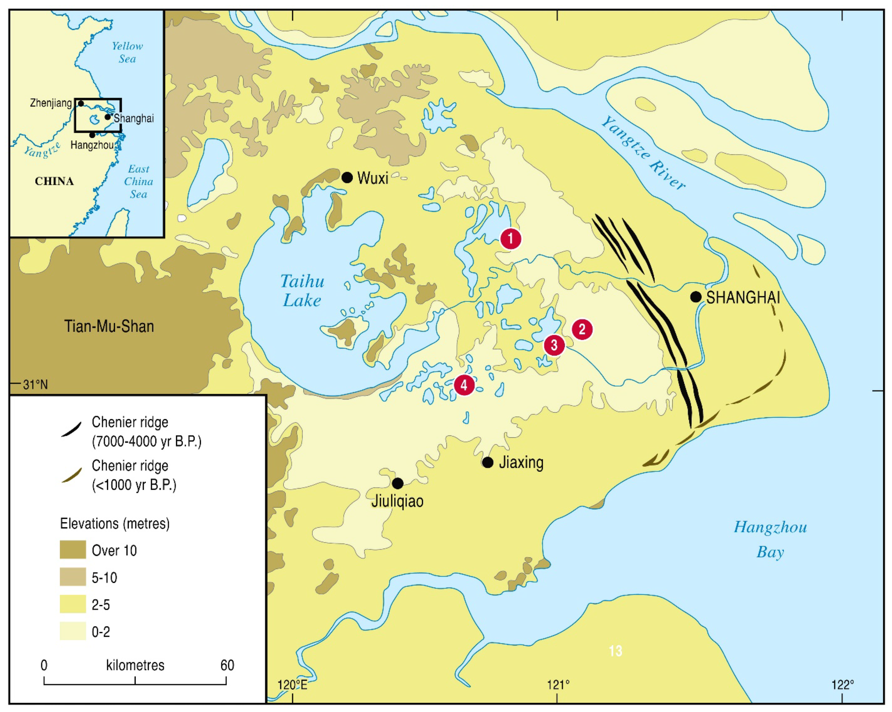
2.1. The Yangtze Delta and the Taihu Lowlands

2.2. Recognition of Past Hydrological Changes
2.3. Climate and Precipitation Changes
2.4. Yangtze Floods
3. Materials and Methods
4. Results
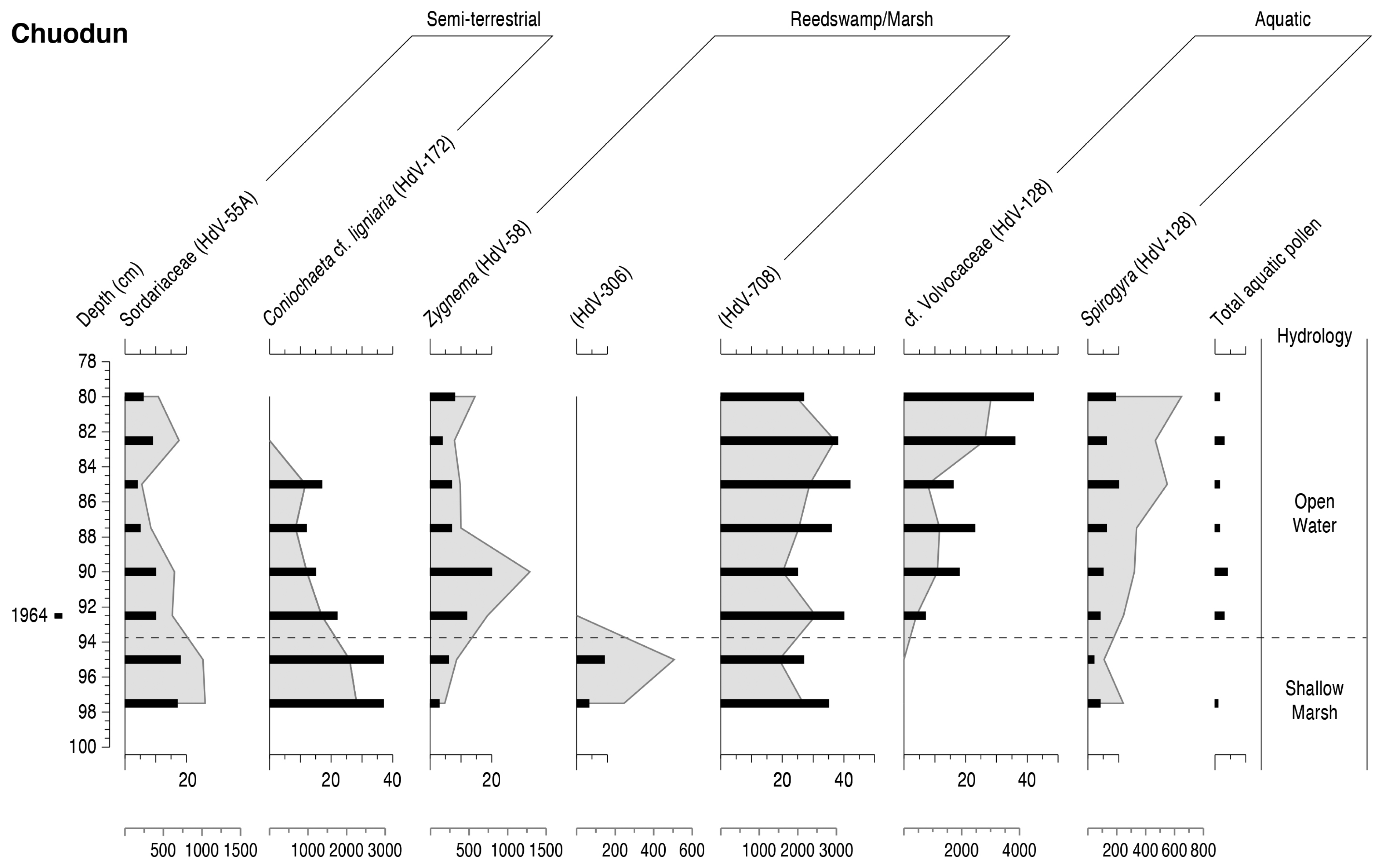
4.1. Chuodun
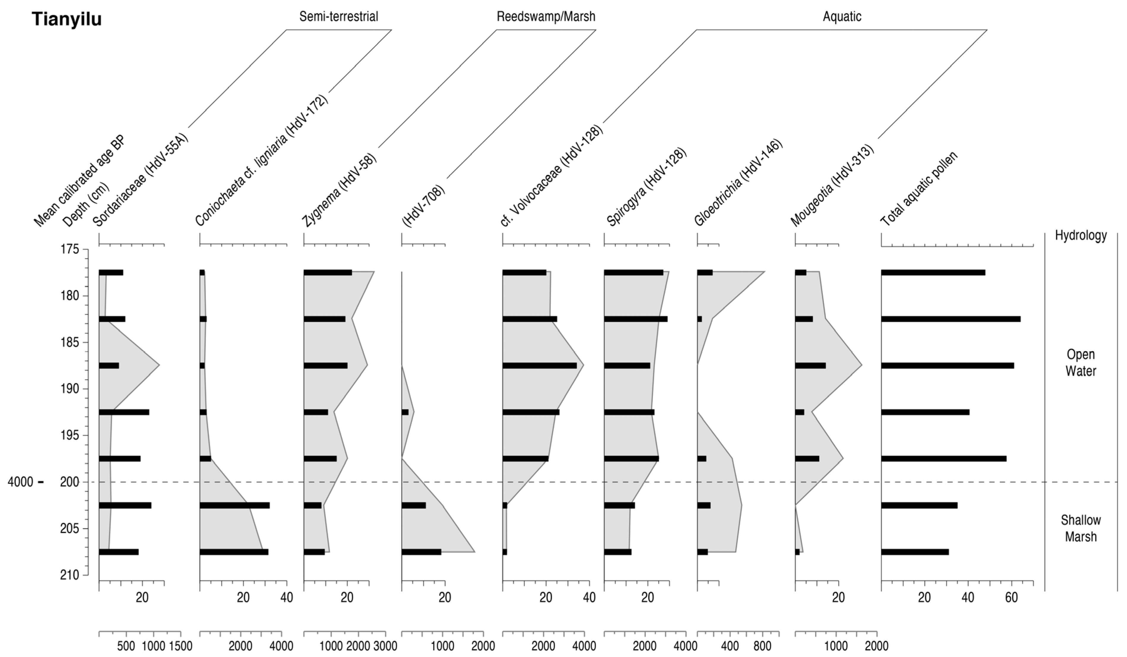
4.2. Tianyilu
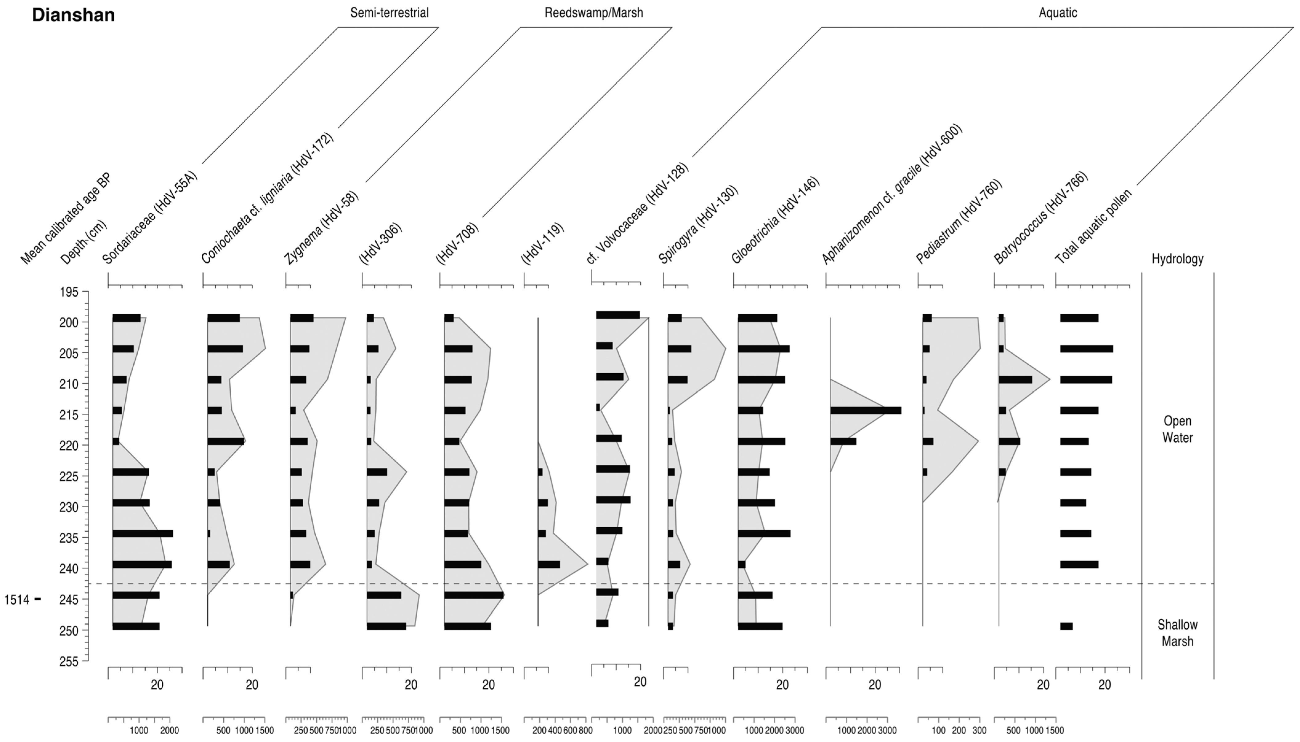
4.3. Dianshan
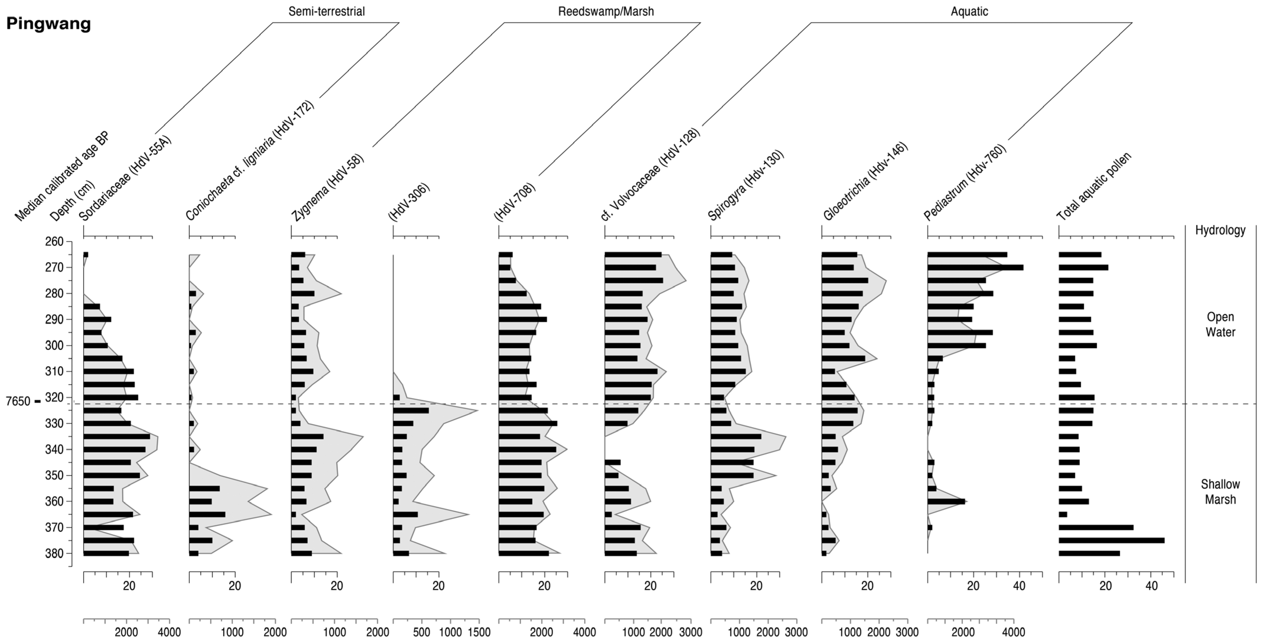
4.4. Pingwang

4.5. Summary

5. Discussion
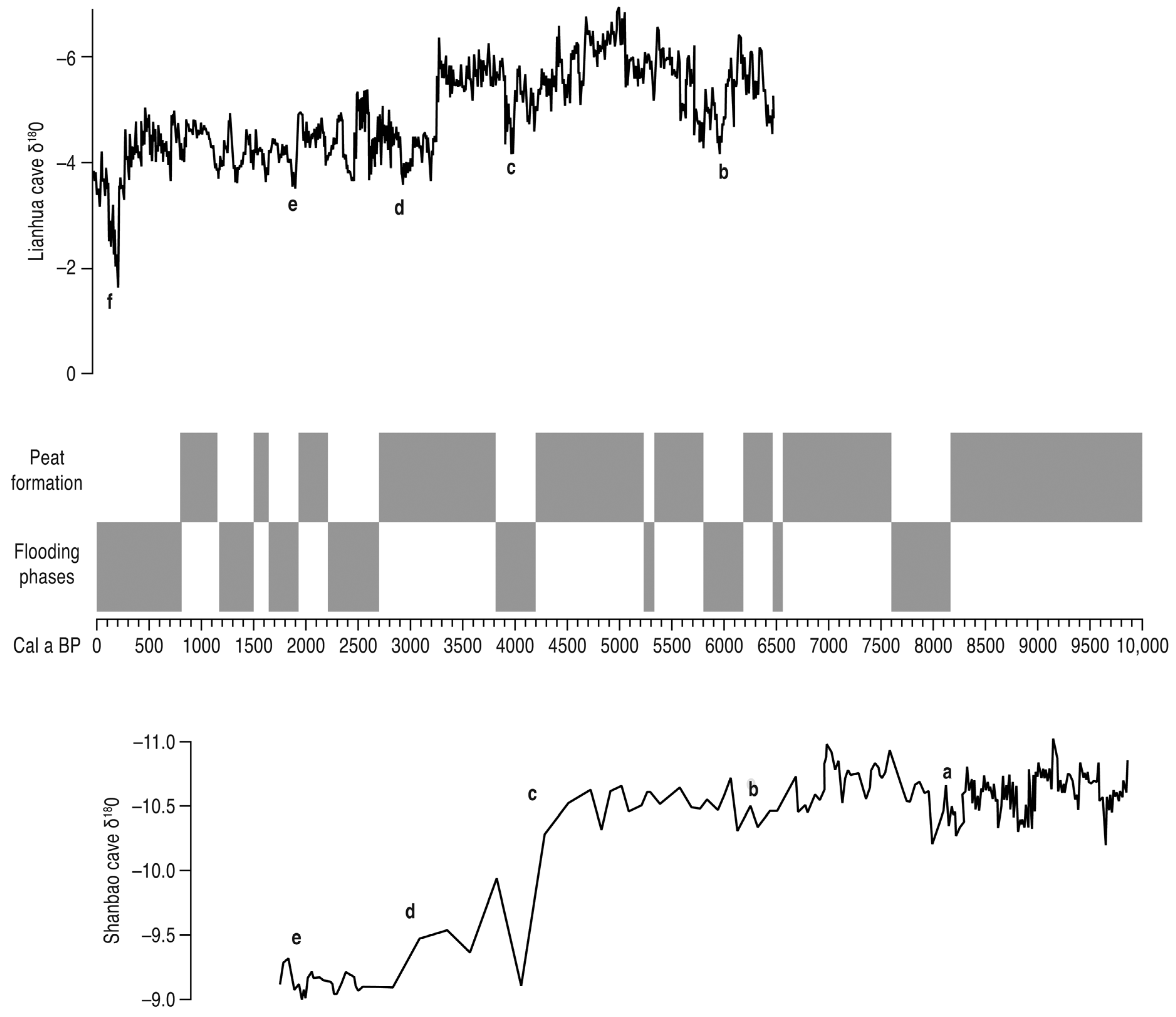
5.1. Hydrology of the Taihu Lowland Plain
5.2. Terrestrialisation and Peat Formation

| Site | Median Age of Peat |
|---|---|
| D2 [327] | 1050 |
| Yaojiang [146] | 1321 |
| T-1 [336] | 1350 |
| Longnan [337] | 1500–1400 |
| Dianshan [81] | 1514 |
| D2 [327] | 1700 |
| Taihu plain [332] | 1710–1414 |
| Qingpu [313] | 2500 |
| Yushan [98] | 2540 |
| YZ-1 [327] | 2651 |
| Taihu plain [332] | 3110–2818 |
| Dongjing [52] | 3177–3111 |
| Taihu plain [332] | 3630 |
| Dongjing [52] | 3657–3639 |
| Guoyuancun [303] | 3795–3710 |
| Baiwaitan [52] | 4291 |
| Maoshan [149] | 4464 |
| Banxiangchan [52] | 4577 |
| Liangzhu (LZ-1) [273] | 4620 |
| Wuguishan [338] | 4630 |
| Yangxi [30] | 4700 |
| HB3 [339] | 4886 |
| Hemudu [188] | 4924–4603 |
| Luojiang [5,311] | 4940–4620 |
| Yushan [340] | 4903 |
| Taihu plain [332] | 5129–4346 |
| Liangzhu (LZ-4) [273] | 5175 |
| Jingtoushan [341] | 5200– 5000 |
| Tianluoshan [11] | 5326 |
| Yaojiang [25] | 5386 |
| Shisanzuqiao [332] | 5434–5347 |
| Tiaoxi valley [1] | 5445 |
| Xiaofengyang [52] | 5517 |
| Fengjing [52] | 5680 |
| Wuguishan [338] | 5815 |
| Hemudu [342] | 6255 |
| Jingtoushan [341] | 6350–6200 |
| Hemudu [178] | 6470–6255 |
| Wujincheng [52] | 6494 |
| Yaojiang [177] | 6509 |
| Jingtoushan [341] | 6650–6500 |
| Xinjie [221] | 6713 |
| Gehu Lake [30] | 6800–6500 |
| Hemudu 1501 [189] | 6932 |
| Luotuodun [343] | 7000 |
| Yuyao [344] | 7000 |
| Xinjie [221] | 7210 |
| Longnan [337] | 7410 |
| Wujiabang [5] | 7509–7499 |
| Taihu plain [332] | 7554–7134 |
| Beihu [2] | 7914 |
| Beihuqiao [329] | 7989–7883 |
| Beihu [2] | 7990 |
| Maqiao [52] | 8069 |
| Hongkou [52] | 8156 |
| Beihu [2] | 8348 |
| Beihuqiao [329] | 8356 |
| ZX-1 [327] | 8481 |
| ZX-1 [250,323] | 8690–8512 |
| Pingwang [260] | c.8850 |
| Zhaoxiang [52] | 9072–8847 |
| HL81063 [339] | 10,027 |
5.3. Major Palaeofloods
5.3.1. The Lower Yangtze and Delta
| Site | Median Age of Flood Events |
|---|---|
| Lake Taihu [168] | 400–0 |
| Dianshan [81] | 800 |
| Jiang-nan [127] | 800–400 |
| Jiang-nan [127] | 1400–1200 |
| Longnan [337] | 1300–1200 |
| Chaohu Lake [135] | 1300 |
| Shangshan [361] | 1710 |
| Longnan [337] | 1800–1700 |
| Chuodun [303] | 1964 |
| Chaohu Lake [135] | 2200, 1800 |
| Guangfulin [311] | 2400 |
| Qingfeng [246] | 3900 |
| Maqiao [362] | 4000–3800 |
| Maoshan [149] | 4000–3900 |
| Maoshan [154] | 4000–3900 |
| Chuodun [363] | c.4000 |
| Dadong [363] | c.4000 |
| Dasanjin [363] | c.4000 |
| Guoyuancun [363] | c.4000 |
| Liangzhu [363,364] | c.4000 |
| Longtanhu [363] | c.4000 |
| Shuitianfan [363] | c.4000 |
| Tangwanli [363] | c.4000 |
| Tenghualuo [142] | c.4000 |
| Taihu plain [365] | c.4000 |
| Yuanjiadi [363] | c.4000 |
| Wangjiashan [363] | c.4000 |
| Xuxiang [363] | c.4000 |
| Yuecheng [363] | c.4000 |
| Tianyilu [303] | 4030 |
| Yuhuicun [366] | 4100 |
| XL [367] | 4200 |
| Caoxieshan [246] | 5250 |
| Baohuashan [246] | 5860 |
| Fuquanshan [246] | 6020 |
| Songze [246] | 6170 |
| Huaihe valley [368] | 6250–5500 |
| Qingfeng [139] | 6400–5500 |
| Jingtoushan [341] | 6500 |
| Pingwang [260] | 7650 |
| HG01 [176] | 7700 |
| Taihu plain [139] | 8100–7700 |
| Lower Yangtze [141] | 9200–8000 |

5.3.2. The Upper and Middle Yangtze
| Site | Median Age of Flood Event |
|---|---|
| Wufeng [349] | 400 |
| Weibicun [160] | 600 |
| Poyang [401] | 800–0 |
| Nanchang [288] | 840–772 |
| Weibicun [160] | 1000–800 |
| Luojiatan [153] | 1800–1700 |
| Liaowadian [151,166] | 1800 |
| Weibicun [160] | 1800 |
| Zhangjiawan [403] | 1800 |
| Xintancun [166] | 1900–1700 |
| Weibicun [160] | 2200 |
| Liaowadian [151,166] | 2200 |
| Majie [400] | 2610 |
| Longgan Lake [278] | 2700 |
| Hanjiang TJW [158] | c.3000 |
| Weihe GCZ [158] | c.3100 |
| Luojiatan [153,166] | 3200–2800 |
| East Dongting [387] | 3900 |
| Baodun [399] | 4000–3800 |
| Caitai [376] | c.4000 |
| Chengtoushan [369] | c.4000 |
| Longgan Lake [278] | c.4000 |
| Dongting [391] | c.4000 |
| Lajia [404] | c.4000 |
| Jianghan [171] | c.4000 |
| Hongqiacun [170] | c.4000 |
| Jinsha [145,170] | c.4000 |
| Mangcheng [399] | c.4000 |
| Three Gorges [29] | c.4000 |
| Shuanghe [399] | c.4000 |
| Zhongba [148] | c.4000 |
| Yichang [405] | c.4000 |
| Yuxi [375] | c.4000 |
| Wulinji [376] | c.4000 |
| Zhongqiao [119,170] | 4100–3800 |
| Zhongqiao [119,170] | 4168 |
| Tanjialing [294] | 4200–4000 |
| Luojiatan [153] | 4200 |
| Zhongqiao [119] | 4900–4600 |
| Dongting [391] | 5800 |
| T0403 Yuxi [295] | 6800–6300 |
| T0403 Yuxi [295] | 7600–7250 |
| Dajiuhu [354] | 9500–7500 |
5.4. Influence of Hydrology on Human Settlement and Land Use
6. Conclusions
Author Contributions
Funding
Institutional Review Board Statement
Informed Consent Statement
Data Availability Statement
Acknowledgments
Conflicts of Interest
References
- Chen, T.; Ryves, D.B.; Wang, Z.; Lewis, J.P.; Yu, X. Mid- to late Holocene geomorphological and hydrological changes in the south Taihu area of the Yangtze delta plain, China. Palaeogeogr. Palaeoclimatol. Palaeoecol. 2018, 498, 127–142. [Google Scholar] [CrossRef] [Green Version]
- Zhang, Y.; Ye, W.; Ma, C.; Li, Y.; Li, C.; Zhu, L. Middle to late Holocene changes in climate, hydrology, vegetation and culture on the Hangjiahu Plain, southeast China. J. Palaeolimnol. 2020. [Google Scholar] [CrossRef]
- Yan, Q.; Huang, S. Evolution of Holocene sedimentary environment in the Hangzhou-Jiaxing-Huzhou Plain. Acta Geogr. Sin. 1987, 42, 1–15. [Google Scholar]
- Yan, Q.; Shao, X. Evolution of shorelines along the north bank of Hangzhou Bay during the late stage of the Holocene transgression. Sci. China B 1989, 32, 347–360. [Google Scholar]
- Qin, J.; Taylor, D.; Atahan, P.; Zhang, X.; Wu, G.; Dodson, J.; Zheng, H.; Itzstein-Davey, F. Neolithic agriculture, freshwater resources and rapid environmental changes on the lower Yangtze, China. Quat. Res. 2011, 75, 55–65. [Google Scholar] [CrossRef]
- Chen, Z.; Song, B.; Wang, Z.; Cai, Y. Late Quaternary evolution of the sub-aqueous Yangtze Delta, China: Sedimentation, stratigraphy, palynology, and deformation. Mar. Geol. 2000, 162, 423–441. [Google Scholar] [CrossRef]
- Yang, X.; Anderson, N.J.; Dong, X.; Shen, J. Surface sediment diatom assemblages and epilimnetic total phosphorous in large, shallow lakes of the Yangtze floodplain: Their relationships and implications for assessing long-term eutrophication. Freshw. Biol. 2008, 53, 1273–1290. [Google Scholar] [CrossRef]
- Xie, C.; Huang, X.; Mu, H.; Yin, W. Impacts of land-use changes on the lakes across the Yangtze floodplain in China. Environ. Sci. Technol. 2017, 51, 3669–3677. [Google Scholar] [CrossRef]
- An, S.; Li, H.; Guan, B.; Zhou, C.; Wang, Z.; Deng, Z.; Zhi, Y.; Liu, Y.; Xu, C.; Fang, S.; et al. China’s natural wetlands: Past problems, current status and future challenges. Ambio 2007, 36, 335–342. [Google Scholar] [CrossRef] [Green Version]
- Li, Y.; Wu, J.; Hou, S.; Shi, C.; Mo, D.; Liu, B.; Zhou, L. Palaeoecological records of environmental change and cultural development from the Liangzhu and Qujialing archaeological sites in the middle and lower reaches of the Yangtze River. Quat. Int. 2010, 227, 29–37. [Google Scholar] [CrossRef]
- Li, C.; Zheng, Y.; Yu, S.; Li, Y.; Shen, H. Understanding the ecological background of rice agriculture on the Ningshao Plain during the Neolithic Age: Pollen evidence from a buried paddy field at the Tianluoshan cultural site. Quat. Sci. Rev. 2012, 35, 131–138. [Google Scholar] [CrossRef]
- Xu, K.; Kong, C.; Liu, G.; Wu, C.; Deng, H.; Zhang, Y.; Zhuang, Q. Changes of urban wetlands in Wuhan, China, from 1987 to 2005. Prog. Phys. Geogr. 2010, 34, 207–220. [Google Scholar]
- Chen, L.; Ren, C.; Zhang, B.; Li, L.; Wang, Z.; Song, K. Spatiotemporal dynamics of coastal wetlands and reclamation in the Yangtze Estuary during the past 50 years (1960s–2015). Chin. Geogr. Sci. 2017, 10, 1007. [Google Scholar] [CrossRef] [Green Version]
- Sun, R.; Yao, P.; Wang, W.; Yue, B.; Liu, G. Assessment of wetland ecosystem health in the Yangtze and Amazon River basins. Int. J. Geo. Inf. 2017, 6, 81. [Google Scholar] [CrossRef] [Green Version]
- Ge, Y.; Zhang, K.; Yang, X. Long-term succession of aquatic plants reconstructed from palynological records in a shallow freshwater lake. Sci. Total Environ. 2018, 643, 312–323. [Google Scholar] [CrossRef] [PubMed]
- Hou, X.; Feng, L.; Tang, J.; Song, X.; Liu, J.; Zhang, Y.; Wang, J.; Xu, Y.; Dai, Y.; Zheng, Y.; et al. Anthropogenic transformation of Yangtze Plain freshwater lakes: Patterns, drivers and impacts. Remote Sens. Environ. 2020, 248, 111998. [Google Scholar] [CrossRef]
- Du, J.; Yang, S.; Feng, H. Recent human impacts on the morphological evolution of the Yangtze River delta foreland: A review and new perspectives. Estuar. Coast. Shelf Sci. 2016, 181, 160–169. [Google Scholar] [CrossRef]
- Nakayama, T.; Shankman, D. Impact of the Three-Gorges Dam and water transfer project on Changjiang floods. Glob. Planet. Chang. 2013, 100, 38–50. [Google Scholar] [CrossRef]
- Yang, Z.; Wang, H.; Saito, Y.; Milliman, J.D.; Xu, K.; Qiao, S.; Shi, G. Dam impacts on the Changjiang (Yangtze) River sediment discharge to the sea: The past 55 years and after the Three Gorges Dam. Water Resour. Res. 2006, 42, W04407. [Google Scholar] [CrossRef]
- Yang, S.; Milliman, J.D.; Xu, K.; Deng, B.; Zhang, X.; Luo, X. Downstream sedimentary and geomorphic impacts of the three Gorges dam on the Yangtze River. Earth-Sci. Rev. 2014, 138, 469–486. [Google Scholar] [CrossRef]
- Yang, H.; Yang, S.; Yu, K.; Milliman, J.D.; Wang, H.; Yang, Z.; Chen, Z.; Zhang, C. Human impacts on sediment in the Yangtze River: A review and new perspectives. Glob. Planet. Chang. 2018, 162, 8–17. [Google Scholar] [CrossRef]
- Wang, Z.; Li, Y.; He, Y. Sediment budget of the Yangtze River. Wat. Resour. Res. 2007, 43, W04401. [Google Scholar] [CrossRef] [Green Version]
- Chen, X. An integrated study of sediment discharge from the Changjiang River, China, and the Delta development since the mid-Holocene. J. Coast. Res. 1996, 12, 26–37. [Google Scholar]
- Chen, X. Changjiang (Yangtze) River delta, China. J. Coast. Res. 1998, 14, 838–858. [Google Scholar]
- Liu, Y.; Sun, Q.; Fan, D.; Dai, B.; Ma, F.; Xu, L.; Chen, J.; Chen, Z. Early to Middle Holocene sea level fluctuation, coastal progradation and the Neolithic occupation in the Yaojiang Valley of southern Hangzhou Bay, Eastern China. Quat. Sci. Rev. 2018, 189, 91–104. [Google Scholar] [CrossRef] [Green Version]
- Song, B.; Li, Z.; Saito, Y.; Okuno, J.I.; Lu, A.; Hua, D.; Li, J.; Li, Y.; Nakashima, R. Initiation of the Changjiang (Yangtze) delta and its response to the mid-Holocene sea level change. Palaeogeogr. Palaeoclimatol. Palaeoecol. 2013, 388, 81–97. [Google Scholar] [CrossRef]
- Wang, Z.; Saito, Y.; Zhan, Q.; Nian, X.; Pan, D.; Wang, L.; Chen, T.; Xie, J.; Li, X.; Jiang, X. Three-dimensional evolution of the Yangtze River mouth, China during the Holocene: Impacts of sea level, climate and human activity. Earth-Sci. Rev. 2018, 185, 938–955. [Google Scholar] [CrossRef]
- Liu, P. The cyclic geography study on the historical floods in the Yangtze River. Adv. Earth Sci. 2000, 15, 503–508. [Google Scholar]
- Zhan, D.; Xie, Y. Study on Ancient Floods; China Water Resources and Hydropower Press: Beijing, China, 2001. [Google Scholar]
- Zhu, C.; Zheng, C.; Ma, C.; Yang, X.; Gao, X.; Wang, H.; Shao, J. On the Holocene sea-level highstand along the Yangtze delta and Ningshao plain, East China. Chin. Sci. Bull. 2003, 48, 2672–2683. [Google Scholar] [CrossRef]
- Zong, Y. Mid-Holocene sea-level highstand along the southeast coast of China. Quat. Int. 2004, 117, 55–67. [Google Scholar] [CrossRef]
- Gu, Y.; Liu, H.; Qin, Y. Postglacial transgression maximum documented by the core sediments of Xixi Wetland, East China. Quat. Int. 2017, 436, 84–95. [Google Scholar] [CrossRef]
- Xiong, H.; Zong, Y.; Li, T.; Long, T.; Huang, G.; Fu, S. Coastal GIA processes revealed by the early to middle Holocene sea-level history of east China. Quat. Sci. Rev. 2020, 233, 106249. [Google Scholar] [CrossRef]
- Yu, F.; Chen, Z.; Ren, X.; Yang, G. Analysis of historical floods on the Yangtze River, China: Characteristics and explanations. Geomorphology 2009, 113, 210–216. [Google Scholar] [CrossRef]
- Zhan, W.; Yang, S.; Liu, X.; Li, J.; Choi, M. Reconstruction of flood events over the last 150 years in the Changjiang reaches. Chin. Sci. Bull. 2010, 55, 2268–2274. [Google Scholar] [CrossRef]
- Zhou, X.; Yu, X. Correlation studies on palaeoflood events in the drainage area of Yangtze and Yellow River during the Holocene. J. Earth Environ. 2013, 4, 1428–1436. (In Chinese) [Google Scholar]
- Ge, Z. The response of Holocene extreme floods in the Upper Yangtze River to changes of southwest monsoon. J. Geophys. Res. 2009, 3, 592–600. (In Chinese) [Google Scholar]
- Yang, D.; Yu, G.; Xie, Y.; Zhan, D.; Li, Z. Sedimentary records of large Holocene floods from the middle reaches of the Yellow River, China. Geomorphology 2000, 33, 73–88. [Google Scholar] [CrossRef]
- Yang, X.; Xia, Z.; Cui, Z. Holocene extreme floods and its sedimentary characteristic in the upper reaches of the Yellow River. Quat. Res. 2005, 21, 81–85. [Google Scholar]
- Yao, P.; Huang, C.; Pang, J.; Zha, X.; Li, X. Palaeoflood hydrological studies in the middle reaches of the Beiluohe River. Acta Geogr. Sin. 2008, 63, 1198–1206. (In Chinese) [Google Scholar]
- Huang, C.; Pang, J.; Zha, X.; Zhou, Y.; Su, H.; Li, Y. Extraordinary floods of 4100–4000 a BP recorded at the Late Neolithic ruins in the Jinghe River Gorges, middle reach of the Yellow River, China. Palaeogeogr. Palaeoclimatol. Palaeoecol. 2010, 289, 1–9. [Google Scholar] [CrossRef]
- Huang, C.; Pang, J.; Zha, X.; Su, H.; Jia, Y. Extraordinary floods related to the climatic event at 4200 a BP on the Qishuihe River, middle reaches of the Yellow River, China. Quat. Sci. Rev. 2011, 30, 460–468. [Google Scholar] [CrossRef]
- Huang, C.; Pang, J.; Zha, X.; Zhou, Y.; Su, H.; Zhang, Y.; Wang, H.; Gu, H. Holocene palaeoflood events recorded by slackwater deposits along the lower Jinghe River valley, middle Yellow River basin, China. J. Quat. Sci. 2012, 27, 485–493. [Google Scholar] [CrossRef]
- Liu, T.; Huang, C.; Pang, J.; Zhou, Y.; Zhang, Y.; Ji, L.; Shang, R. Extraordinary hydro-climatic events during 1800–1600 yr BP in the Jin–Shaan Gorges along the middle Yellow River, China. Palaeogeogr. Palaeoclimatol. Palaeoecol. 2014, 410, 143–152. [Google Scholar] [CrossRef]
- Zhang, Y.; Huang, C.; Tan, Z.; Chen, Y.; Qiu, H.; Huang, C.; Li, Y.; Zhang, Y.; Li, X.; Shulmeister, J.; et al. Prehistoric and historic overbank floods in the Luoyang Basin along the Luohe River, middle Yellow River basin, China. Quat. Int. 2019, 521, 118–128. [Google Scholar] [CrossRef]
- Ishii, Y.; Hori, K.; Momohara, A. Middle to Late Holocene flood activity estimated from loss on ignition of peat in the Ishikari lowland, northern Japan. Glob. Planet. Chang. 2017, 153, 1–15. [Google Scholar] [CrossRef]
- Suzuki, Y.; Tada, R.; Nagashima, K.; Nakagawa, T.; Gotanda, K.; Haraguchi, T.; Schlolaut, G. Extreme flood events and their frequency variations during the middle to late-Holocene recorded in the sediment of Lake Suigetsu, central Japan. Holocene 2020. [Google Scholar] [CrossRef]
- Lim, J.; Lee, J.; Hong, S.; Kim, J. Late Holocene flooding records from the floodplain deposits of the Yugu river, South Korea. Geomorphology 2013, 180–181, 109–119. [Google Scholar] [CrossRef]
- Lim, J.; Lee, J.; Hong, S.; Kim, J.; Yi, S.; Nahm, W. Holocene changes in flooding frequency in South Korea and their linkage to centennial-to-millennial-scale El Niño-Southern Oscillation activity. Quat. Res. 2017, 87, 37–48. [Google Scholar] [CrossRef]
- Park, J.; Park, J.; Yi, S.; Kim, J.; Lee, E.; Choi, J. Abrupt Holocene climate shifts in coastal East Asia, including the 8.2 ka, 4.2 ka, and 2.8 ka BP events, and societal responses on the Korean peninsula. Sci. Rep. 2019, 9, 10806. [Google Scholar] [CrossRef]
- Li, B.; Liu, H.; Wu, L.; McCloskey, T.A.; Li, K.; Mao, L. Linking the vicissitude of Neolithic cities with mid Holocene environment and climate changes in the middle Yangtze River, China. Quat. Int. 2014, 321, 22–28. [Google Scholar] [CrossRef]
- Wu, L.; Zhu, C.; Zheng, C.; Li, F.; Wang, X.; Li, L.; Sun, W. Holocene environmental change and its impacts on human settlement in the Shanghai area, East China. Catena 2014, 114, 78–89. [Google Scholar] [CrossRef]
- Duan, C.; Gan, X.; Wang, J.; Chien, P. Relocation of civilization centres in ancient China: Environmental factors. Ambio 1998, 27, 572–575. [Google Scholar]
- Zhang, Z.; Tian, H.; Cazelles, B.; Kausrud, K.L.; Bräuning, A.; Guo, F.; Stenseth, N.C. Periodic climate cooling enhanced natural disasters and wars in China during AD 10–1900. Proc. R. Soc. B Biol. Sci. 2010, 277, 3745–3753. [Google Scholar] [CrossRef] [PubMed] [Green Version]
- Xiao, L.; Fang, X.; Zheng, J.; Zhao, W. Famine, migration and war: Comparison of climate change impacts and social responses in North China between the late Ming and late Qing dynasties. Holocene 2015, 25, 900–910. [Google Scholar] [CrossRef]
- Lee, H.; Zhang, D.; Pei, Q.; Jia, X.; Yue, R. Quantitative analysis of the impact of droughts and floods on internal wars in China over the last 500 years. Sci. China D Earth Sci. 2017, 60, 2078–2088. [Google Scholar] [CrossRef]
- Pei, Q. Migration for survival under natural disasters: A reluctant and passive choice for agriculturalists in historical China. Sci. China D Earth Sci. 2017, 60, 2089–2096. [Google Scholar] [CrossRef]
- Wu, Q.; Zhao, Z.; Liu, L.; Granger, D.E.; Wang, H.; Cohen, D.J.; Wu, X.; Ye, M.; Bar-Yosef, O.; Lu, B.; et al. Outburst flood at 1920 BCE supports historicity of China’s Great Flood and the Xia dynasty. Science 2016, 353, 579–582. [Google Scholar] [CrossRef]
- Wang, H.; Tong, K.; Hu, G.; Wang, P.; Li, D.; Huang, J.; Cao, G.; Zhang, J.; Chen, J. Dam and megafloods at the First Bend of the Yangtze River since the last Glacial Maximum. Geomorphology 2021, 107491. [Google Scholar] [CrossRef]
- Jiang, R.; King, L.; Gemmer, M.; Kundzewicz, Z.W. (Eds.) Climate Change and Yangtze Floods; Science Press: Beijing, China, 2004. [Google Scholar]
- Ding, Y.; Chan, J. The East Asian summer monsoon: An overview. Meteorol. Atmos. Phys. 2005, 89, 117–142. [Google Scholar]
- Chen, F.; Xu, Q.; Chen, J.; Birks, H.J.B.; Liu, J.; Zhang, S.; Jin, L.; An, C.; Telford, R.J.; Cao, X.; et al. East Asian summer monsoon precipitation variability since the last deglaciation. Sci. Rep. 2015, 5, 11186. [Google Scholar] [CrossRef] [Green Version]
- Kundzewicz, Z.W.; Huang, J.; Pinskwar, I.; Su, B.; Szwed, M.; Jiang, T. Climate variability and floods in China—A review. Earth-Sci. Rev. 2020, 211, 103434. [Google Scholar] [CrossRef]
- Ren, G. Decline of the mid-to late Holocene forests in China: Climatic change or human impact? J. Quat. Sci. 2000, 15, 273–281. [Google Scholar] [CrossRef]
- Yin, H.; Li, C. Human impact on floods and flood disasters on the Yangtze River. Geomorphology 2001, 41, 105–109. [Google Scholar] [CrossRef]
- Wang, Z.; Li, M.; Zhang, R.; Zhuang, C.; Liu, Y.; Saito, Y.; Xie, J.; Zhao, B. Impacts of human activity on the late-Holocene development of the subaqueous Yangtze delta, China, as shown by magnetic properties and sediment accumulation rates. Holocene 2011, 21, 393–407. [Google Scholar] [CrossRef]
- Chen, W.; Song, B.; Shu, J.; Jin, C.; Wang, W. Vegetation history with implication of climate changes and human impacts over the last 9000 years in the Lake Nanyi area, Anhui Province, East China. Palaeoworld 2020. [Google Scholar] [CrossRef]
- Guo, Y.; Mao, L.; Mo, D.; Shu, J.; Guo, A. Vegetation dynamics and human activities over the past 1300 years revealed by pollen record at the Tongguan kilns, lower Xianjiang River, China. Quat. Int. 2021, 577, 139–146. [Google Scholar] [CrossRef]
- Wang, P.; Shen, H. The Changjiang (Yangtze) River Delta: A review. In Deltas of the World; Kay, R., Ed.; American Society of Civil Engineers: New York, NY, USA, 1993; pp. 16–29. [Google Scholar]
- Hori, K.; Saito, Y. An early Holocene sea-level jump and delta initiation. Geophys. Res. Lett. 2007, 34, L18401. [Google Scholar] [CrossRef]
- Saito, Y.; Yang, Z.; Hori, K. The Huanghe (Yellow River) and Changjiang (Yangtze River) deltas: A review on their characteristics, evolution and sediment discharge during the Holocene. Geomorphology 2001, 41, 219–231. [Google Scholar] [CrossRef]
- Hori, K.; Saito, Y.; Zhao, Q.; Cheng, X.; Wang, P.; Sato, Y.; Li, C. Sedimentary facies and Holocene progradation rates of the Changjiang (Yangtze) delta, China. Geomorphology 2001, 41, 233–248. [Google Scholar] [CrossRef]
- Qin, J.; Wu, G.; Zheng, H.; Zhou, Q. The palynology of the first Hard Clay layer (late Pleistocene) from the Yangtze delta, China. Rev. Palaeobot. Palynol. 2008, 149, 63–72. [Google Scholar] [CrossRef]
- Fan, D.; Wu, Y.; Zhang, Y.; Burr, G.; Huo, M.; Li, J. South flank of the Yangtze Delta: Past, present and future. Mar. Geol. 2017, 392, 78–93. [Google Scholar] [CrossRef]
- Wang, J.; Chen, F.; Yang, B.; Chen, J. New advances in research on the Little Ice Age climate change. Adv. Clim. Chang. Res. 2006, 2, 21–27, (In Chinese with English abstract). [Google Scholar]
- Zhang, G.; Li, C. Sources of sediments filling the Qiantangjiang estuary incised valley since the Last Glaciation. Chin. Sci. Bull. 1998, 43, 1280–1284. [Google Scholar] [CrossRef]
- Li, C.; Wang, P.; Sun, H.; Zhang, J.; Fan, D.; Deng, B. Late Quaternary incised-valley fill of the Yangtze delta (China): Its stratigraphic framework and evolution. Sediment. Geol. 2002, 152, 133–158. [Google Scholar] [CrossRef]
- Lin, C.; Zhuo, H.; Gao, S. Sedimentary facies and evolution in the Qiantang River incised valley, eastern China. Mar. Geol. 2005, 219, 235–259. [Google Scholar] [CrossRef]
- Zhang, X.; Lin, C.; Dalrymple, R.W.; Gao, S.; Li, Y. Facies architecture and depositional model of a macrotidal incised-valley succession (Qiantang River estuary, eastern China), and differences from other macrotidal systems. GSA Bull. 2014, 126, 499–522. [Google Scholar] [CrossRef] [Green Version]
- Wang, Z.; Zhuang, C.C.; Saito, Y.; Chen, J.; Zhan, Q.; Wang, X.D. Early mid-Holocene sea-level change and coastal environmental response on the southern Yangtze delta plain, China: Implications for the rise of Neolithic culture. Quat. Sci. Rev. 2012, 35, 51–62. [Google Scholar] [CrossRef]
- Innes, J.B.; Zong, Y.; Xiong, H.; Wang, Z.; Chen, Z. Pollen and non-pollen palynomorph analyses of Upper Holocene sediments from Dianshan, Yangtze coastal lowlands, China: Hydrology, vegetation history and human activity. Palaeogeogr. Palaeoclimatol. Palaeoecol. 2019, 523, 30–47. [Google Scholar] [CrossRef] [Green Version]
- Stanley, D.J.; Warne, A.G. Worldwide initiation of Holocene marine deltas by deceleration of sea-level rise. Science 1994, 265, 228–231. [Google Scholar] [CrossRef]
- Sun, S.; Wu, Y.; Dong, B. Evolution and modern sediment of the Taihu Lake. Sci. China Ser. B 1987, 12, 78–86. [Google Scholar]
- Hong, X. Origin and evolution of the Taihu Lake. Mar. Geol. Quat. Geol. 1991, 11, 87–99. (In Chinese) [Google Scholar]
- Zong, Y.; Innes, J.B.; Wang, Z.; Chen, Z. Mid-Holocene coastal hydrology and salinity changes in the east Taihu area of the lower Yangtze wetlands, China. Quat. Res. 2011, 76, 69–82. [Google Scholar] [CrossRef]
- Chen, X.; Zong, Y. Coastal erosion along the Changjiang deltaic shoreline, China: History and prospective. Estuar. Coast. Shelf Sci. 1998, 46, 733–742. [Google Scholar] [CrossRef]
- Xin, Z.; Xie, Z. Construction of the simulating model for geomorphic evolution on the Yangtze delta, China. Acta Geogr. Sin. 2006, 61, 549–560. (In Chinese) [Google Scholar]
- Bevington, A.E.; Twilley, R.R. Island edge morphodynamics along a chronosequence in a prograding deltaic wetland. J. Coast. Res. 2018, 34, 806–817. [Google Scholar] [CrossRef]
- Yang, S.; Ding, P.; Chen, S. Changes in progradation rate of the tidal flats at the mouth of the Changjiang (Yangtze) River, China. Geomorphology 2001, 38, 167–180. [Google Scholar] [CrossRef]
- Yang, S.; Xu, K.; Milliman, J.D.; Yang, H.; Wu, C. Decline of Yangtze River water and sediment discharge: Impact from natural and anthropogenic changes. Sci. Rep. 2015, 5, 12581. [Google Scholar] [CrossRef] [PubMed]
- Yang, S.; Milliman, J.D.; Li, P.; Xu, K. 50,000 dams later: Erosion of the Yangtze river and its delta. Glob. Planet. Chang. 2011, 75, 14–20. [Google Scholar] [CrossRef]
- Liu, J.; Xu, K.; Li, A.; Milliman, J.D.; Velozzi, D.M.; Xiao, S.; Yang, Z. Flux and fate of Yangtze River sediment delivered to the East China Sea. Geomorphology 2007, 85, 208–224. [Google Scholar] [CrossRef]
- Chen, X.; Yan, Y.; Fu, R.; Dou, X.; Zhang, E. Sediment transport from the Yangtze River, China, into the sea over the post-Three Gorge Dam period: A discussion. Quat. Int. 2008, 186, 55–64. [Google Scholar] [CrossRef]
- Tan, C.; Huang, B.; Liu, F.; Yang, Q.; Jiang, C.; Zhang, S. Transformation of the three largest Chinese river deltas in response to the reduction of sediment discharges. J. Coast. Res. 2016, 32, 1402–1416. [Google Scholar] [CrossRef]
- Gao, J.; Shi, Y.; Sheng, H.; Kettner, A.J.; Yang, Y.; Jia, J.; Wang, Y.; Li, J.; Chen, Y.; Zou, X.; et al. Rapid response of the Changjiang (Yangtze) River and East China Sea source-to-sink conveying system to human induced catchment perturbations. Mar. Geol. 2019, 414, 1–17. [Google Scholar] [CrossRef]
- Zhao, Y.; Zou, X.; Liu, Q.; Xu, M.; Yao, Y. Recent morphological changes of the Changjiang (Yangtze River) mega-delta in the Anthropocene, China: Impact from natural and anthropogenic changes. Holocene 2021, 31, 791–801. [Google Scholar] [CrossRef]
- Hao, X.; Ouyang, X.; Zheng, L.; Zhuo, B.; Liu, Y. Palynological evidence for early to mid-Holocene sea-level fluctuations over the present-day Ningshao Coastal Plain in Eastern China. Mar. Geol. 2020, 426, 106213. [Google Scholar] [CrossRef]
- Wang, Z.; Ryves, D.B.; Lei, S.; Nian, X.; Lv, Y.; Tang, L.; Wang, L.; Wang, J.; Chen, J. Middle Holocene marine flooding and human response in the south Yangtze coastal plain, East China. Quat. Sci. Rev. 2018, 187, 80–93. [Google Scholar] [CrossRef] [Green Version]
- Tang, L.; Shu, J.; Chen, J.; Wang, Z. Mid- to late Holocene vegetation change recorded at a Neolithic site in the Yangtze coastal plain, East China. Quat. Int. 2019, 519, 122–130. [Google Scholar] [CrossRef]
- Huang, J.; Li, Y.; Ding, F.; Zheng, T.; Meadows, M.E.; Wang, Z. Sedimentary records of mid-Holocene coastal flooding at a Neolithic site on the southeast plain of Hangzhou Bay, east China. Mar. Geol. 2021, 431, 106380. [Google Scholar] [CrossRef]
- Zhao, B.; Wang, Z.; Chen, Z.; Wu, G. Climate, vegetation and geomorphology evolution since 8 ka BP recorded by sediments from dish-like depression of Taihu Lake plain. J. Palaeogeogr. 2007, 9, 321–330. [Google Scholar]
- Liu, C.; Walker, H.J. Sedimentary characteristics of cheniers and the formation of the chenier plains of East China. J. Coast. Res. 1989, 5, 353–368. [Google Scholar]
- Yan, Q.; Xu, S.; Shao, X. Holocene cheniers in the Yangtze delta, China. Mar. Geol. 1989, 90, 337–343. [Google Scholar] [CrossRef]
- Zhao, X. Cheniers in China, an overview. Mar. Geol. 1989, 90, 311–320. [Google Scholar] [CrossRef]
- Chen, J.; Liu, C.; Zhang, C.; Walker, H.J. Geomorphological development and sedimentation in Qiantang estuary and Hangzhou Bay. J. Coast. Res. 1990, 6, 559–572. [Google Scholar]
- Walker, D. Direction and rate in some British post-glacial hydroseres. In Studies in the Vegetational History of the British Isles; Walker, D., West, R.G., Eds.; Cambridge University Press: Cambridge, UK, 1970; pp. 117–139. [Google Scholar]
- Rodwell, J.S. British Plant Communities Volume 5. Aquatic Communities, Swamps and Tall-Herb Fens; Cambridge University Press: Cambridge, UK, 1995. [Google Scholar]
- Shen, J. Spatiotemporal variations of Chinese lakes and their driving mechanisms since the Last Glacial Maximum: A review and synthesis of lacustrine sediment archives. Chin. Sci. Bull. 2013, 58, 17–31. [Google Scholar] [CrossRef] [Green Version]
- Xu, Y.; Lai, Z.; Li, C. Sea-level change as the driver for lake formation in the Yangtze plain—A review. Glob. Planet. Chang. 2019, 181, 102980. [Google Scholar] [CrossRef]
- Zhang, F.; Xue, B.; Yao, S. The lake status records and palaeoclimatic changes of China since the last Interstadial. Quat. Int. 2019, 527, 12–18. [Google Scholar] [CrossRef]
- Ran, M.; Chen, L. The 4.2 ka BP climatic event and its cultural responses. Quat. Int. 2019, 521, 158–167. [Google Scholar] [CrossRef]
- Yang, H.; Xie, Z.; Yang, D. Formation and evolution of the Taihu lake and the Holocene sea level. In Collection of the Quaternary Glaciation and Quaternary Geology; Yang, H.R., Ed.; Publishing House of Geology: Beijing, China, 1987; pp. 49–84. (In Chinese) [Google Scholar]
- Chang, W.; Xu, X.; Yang, J.; Liu, J. Evolution in Taihu Lake ecosystem as evidence of changes in sediment profiles. J. Lake Sci. 1994, 6, 217–226. [Google Scholar] [CrossRef] [Green Version]
- Chen, Z.; Hong, X.; Li, S.; Wang, L.; Shi, X. Study of archaeology-related environment evolution of Taihu Lake in southern Changjiang Delta Plain. Acta Geogr. Sin. 1997, 52, 131–137. [Google Scholar]
- Yang, X.; Zhu, Y.; Jiang, X.; Wu, Y.; Wang, S. Environmental changes from spore-pollen record of Mianyang region over the past 10000 years. J. Lake Sci. 1998, 10, 23–29. (In Chinese) [Google Scholar]
- Qu, W.; Xue, B.; Dickman, M.D.; Wang, S.; Fan, C.; Wu, R.; Zhang, P.; Chen, J.; Wu, Y. A 14 000 year record of palaeoenvironmental change in the western basin of China’s third largest lake, Lake Taihu. Hydrobiologia 2000, 432, 113–120. [Google Scholar] [CrossRef]
- Yu, S.; Zhu, C.; Song, H.; Qu, W. Role of climate in the rise and fall of Neolithic cultures on the Yangtze Delta. Boreas 2000, 29, 157–165. [Google Scholar] [CrossRef]
- Wang, J.; Chen, X.; Zhu, X.; Liu, J.; Chang, W. Taihu Lake, lower Yangtze drainage basin: Evolution, sedimentation rate and the sea level. Geomorphology 2001, 41, 183–193. [Google Scholar] [CrossRef]
- Wu, L.; Zhu, C.; Ma, C.; Li, F.; Meng, H.; Liu, H.; Li, L.; Wang, X.; Sun, W.; Song, Y. Mid-Holocene palaeoflood events recorded at the Zhongqiao Neolithic cultural site in the Jianghan Plain, middle Yangtze River Valley, China. Quat. Sci. Rev. 2017, 173, 145–160. [Google Scholar] [CrossRef]
- Kajita, H.; Kawahata, H.; Wang, K.; Zheng, H.; Yang, S.; Ohkouchi, N.; Utsunomiya, M.; Zhou, B.; Zheng, B. Extraordinary cold episodes during the mid-Holocene in the Yangtze delta: Interruption of the earliest rice cultivating civilization. Quat. Sci. Rev. 2018, 201, 418–428. [Google Scholar] [CrossRef]
- Baker, V.R. Palaeoflood hydrology and extraordinary flood events. J. Hydrol. 1987, 96, 79–99. [Google Scholar] [CrossRef]
- Tian, R.; Cao, C.; Peng, L.; Ma, G.; Bao, D.; Guo, J.; Yomwan, P. The use of HJ-1A/B satellite data to detect changes in the size of wetlands in response to a sudden turn from drought to flood in the middle and lower reaches of the Yangtze River system in China. Geomat. Nat. Haz. Risk 2016, 7, 287–307. [Google Scholar] [CrossRef]
- Acreman, M.; Holden, J. How wetlands affect floods. Wetlands 2013, 33, 773–786. [Google Scholar] [CrossRef] [Green Version]
- Zheng, S.; Feng, L. Historical evidence on climatic instability above normal in cool periods in China. Sci. China Ser. B 1986, 29, 441–448. [Google Scholar]
- Chen, J. An approach to the data processing of historical climate materials on the basis of floods and droughts of Taihu Basin. Acta Geogr. Sin. 1987, 42, 231–242. (In Chinese) [Google Scholar]
- Zhang, J.; Crowley, T.J. Historic climate records in China and reconstruction of past climate. J. Clim. 1989, 2, 833–849. [Google Scholar] [CrossRef]
- Zheng, J.; Wang, W.; Ge, Q.; Man, Z.; Zhang, P. Precipitation variability and extreme events in eastern China during the past 1500 years. Terr. Atmos. Ocean. Sci. 2006, 17, 579–592. [Google Scholar] [CrossRef] [Green Version]
- Zhang, Q.; Chen, J.; Becker, S. Flood/drought change of last millennium in the Yangtze Delta and its possible connections with Tibetan climatic changes. Glob. Planet. Chang. 2007, 57, 213–221. [Google Scholar] [CrossRef]
- Zhang, Q.; Gemmer, M.; Chen, J. Climate changes and flood/drought risk in the Yangtze Delta, China during the past millennium. Quat. Int. 2008, 176–177, 62–69. [Google Scholar] [CrossRef]
- Zhang, Q.; Chen, Y.; Chen, J. Flood/drought variability in the Yangtze Delta and association with the climatic changes from the Guliya ice core: A wavelet approach. Quat. Int. 2008, 189, 163–172. [Google Scholar] [CrossRef]
- Yin, J.; Su, Y.; Fang, X. Climate change and social vicissitudes in China over the past two millennia. Quat. Res. 2016, 86, 133–143. [Google Scholar] [CrossRef] [Green Version]
- Li, T.; Li, J.; Zhang, D.D. Yellow River flooding during the past two millennia from historical documents. Prog. Phys. Geogr. 2020, 44, 661–678. [Google Scholar] [CrossRef]
- Hao, Z.; Wu, M.; Zheng, J.; Chen, J.; Zhang, X.; Luo, S. Patterns in data of extreme droughts/floods and harvests grades derived from historical documents in eastern China during 801–1910. Clim. Past 2020, 16, 101–116. [Google Scholar] [CrossRef] [Green Version]
- Wan, Z.; Gao, Z.; Chen, X.; Zhang, Z.; Liao, F.; Liu, G.; Jia, Y.; Jiang, M. Water level reconstruction and characteristic diagnosis of China’s largest freshwater lake for the past 500 years. Quat. Int. 2020, 558, 66–74. [Google Scholar] [CrossRef]
- Wu, L.; Wang, X.; Zhu, C.; Zhang, G.; Li, F.; Li, L.; Li, S. Ancient culture decline after the Han Dynasty in the Chaohu Lake basin, East China: A geoarchaeological perspective. Quat. Int. 2012, 275, 23–29. [Google Scholar] [CrossRef]
- Wu, L.; Li, F.; Zhu, C.; Li, L.; Li, B. Holocene environmental change and archaeology, Yangtze River Valley, China: Review and prospects. Geosci. Front. 2012, 3, 875–892. [Google Scholar] [CrossRef] [Green Version]
- Yi, C.; Liu, H.; Rose, N.L.; Yang, H.; Ni, L.; Xie, P. Sediment sources and the flood record from Wanghu lake, in the middle reaches of the Yangtze River. J. Hydrol. 2006, 329, 568–576. [Google Scholar] [CrossRef]
- Wang, M.; Zheng, H.; Xie, X.; Fan, D.; Yang, S.; Zhao, Q.; Wang, K. A 600-year flood history in the Yangtze River drainage: Comparison between a subaqueous delta and historical records. Chin. Sci. Bull. 2011, 56, 188–195. [Google Scholar] [CrossRef] [Green Version]
- Zhu, C.; Yu, S.; Shi, W. Holocene deposits and paleo-floods on the north bank of the Yangtze River, Nanjing area. Geogr. Res. 1997, 16, 23–30. (In Chinese) [Google Scholar]
- Xie, Y.; Wang, W.; Wang, P. Characteristics of grain size for palaeoflood slackwater deposits. Hydrology 2000, 20, 18–20. [Google Scholar]
- Yu, S.; Zhu, C.; Wang, F. Radiocarbon constraints on the Holocene flood deposits of the Ning-Zhen mountains, lower Yangtze River area of China. J. Quat. Sci. 2003, 18, 521–525. [Google Scholar] [CrossRef]
- Li, L.; Zhu, C.; Jiang, F.; Zhao, Q.; Lin, L. Research on the disappearance causes of the Tenghualuo Site in Lianyungang, Jiangsu Province, China. Chin. Sci. Bull. 2008, 53, 161–176. [Google Scholar] [CrossRef] [Green Version]
- Wu, L.; Wang, X.; Zhou, K.; Mo, D.; Zhu, C.; Gao, C.; Zhang, G.; Li, L.; Han, W. Transmutation of ancient settlements and environmental changes between 6000 and 2000 a BP in the Chaohu Lake Basin, East China. J. Geogr. Sci. 2010, 20, 687–700. [Google Scholar] [CrossRef]
- Luo, C.; Zheng, Z.; Zou, H.; Pan, A.; Fang, G.; Bai, J.; Li, J.; Yang, M. Palaeoenvironmental significance of grain-size distribution of river flood deposits: A study of the archaeological sites of the Apengjiang River Drainage, upper Yangtze region, Chongqing, China. J. Archaeol. Sci. 2013, 40, 827–840. [Google Scholar] [CrossRef]
- Jia, T.; Ma, C.; Zhu, C.; Guo, T.; Xu, J.; Guan, H.; Zeng, M.; Huang, M.; Zhang, Q. Depositional evidence of palaeofloods during 4.0–3.6 ka BP at the Jinsha site, Chengdu Plain, China. Quat. Int. 2017, 440, 78–89. [Google Scholar] [CrossRef]
- Liu, X.; Kettner, A.J.; Cheng, J.; Dai, S. Sediment characteristics of the Yangtze River during major flooding. J. Hydrol. 2020, 590, 125417. [Google Scholar] [CrossRef]
- Yi, C.; Appleby, P.G.; Boyle, J.F.; Rose, N.L.; Dai, X.; Xie, P. The sedimentary record of a significant flooding event in Lake Taihu on the Yangtze Delta, China. J. Coast. Res. 2004, 43, 89–100. [Google Scholar]
- Zhu, C.; Zheng, C.; Ma, C.; Sun, Z.; Zhu, G.; Wang, H.; Gao, H.; Wang, P.; Huang, R. Identifying palaeoflood deposits archived in Zhongba Site, the Three Gorges reservoir region of the Yangtze River, China. Chin. Sci. Bull. 2005, 50, 2493–2504. [Google Scholar] [CrossRef]
- Jin, Y.; Mo, D.; Li, Y.; Ding, P.; Zong, Y.; Zhuang, Y. Ecology and hydrology of early rice farming: Geoarchaeological and palaeo-ecological evidence from the Late Holocene paddy field site at Maoshan, the lower Yangtze. Archaeol. Anthropol. Sci. 2019, 11, 1851–1863. [Google Scholar] [CrossRef] [Green Version]
- Yang, D.; Xie, Y. Palaeoflood slack water deposits. Acta Sedimentol. Sin. 1997, 15, 29–32. (In Chinese) [Google Scholar]
- Huang, C.; Pang, J.; Zha, X.; Zhou, Y.; Yin, S.; Su, H.; Zhou, L.; Yang, J. Extraordinary hydro-climatic events during the period AD 200–300 recorded by slackwater deposits in the upper Hanjiang River valley, China. Palaeogeogr. Palaeoclimatol. Palaeoecol. 2013, 374, 274–283. [Google Scholar] [CrossRef]
- Zhang, Y.; Huang, C.; Pang, J.; Zha, X.; Zhou, Y.; Zhou, Z.; Wang, J.; Gu, H. Sedimentary studies of the Holocene flood slackwater deposits in the lower reaches of the Jinghe River. Chin. J. Soil Sci. 2012, 43, 522–528, (In Chinese with English abstract). [Google Scholar]
- Zhang, Y.; Huang, C.; Pang, J.; Zha, X.; Zhou, Y.; Gu, H. Holocene paleofloods related to climatic events in the upper reaches of the Hanjiang River valley, middle Yangtze River basin, China. Geomorphology 2013, 195, 1–12. [Google Scholar] [CrossRef]
- Zhuang, Y.; Ding, P.; French, C. Water management and agricultural intensification of rice farming at the late-Neolithic site of Maoshan, Lower Yangtze River, China. Holocene 2014, 24, 531–545. [Google Scholar] [CrossRef]
- Liu, T.; Huang, C.; Pang, J.; Zha, X.; Zhou, Y.; Zhang, Y.; Ji, L. Late Pleistocene and Holocene palaeoflood events recorded by slackwater deposits in the upper Hanjiang River valley, China. J. Hydrol. 2015, 529, 499–510. [Google Scholar] [CrossRef]
- Liu, X.; Min, F.; Kettner, A.J. The impact of large to extreme flood events on floodplain evolution of the middle and lower reaches of the Yangtze River, China. Catena 2019, 176, 394–409. [Google Scholar] [CrossRef]
- Zha, X.; Huang, C.; Pang, J. Palaeofloods recorded by slackwater deposits on the Qishuihe River in the Middle Yellow River. J. Geogr. Sci. 2009, 19, 681–690. [Google Scholar] [CrossRef]
- Zha, X.; Huang, C.; Pang, J.; Zhou, Y. Reconstructing the extraordinary palaeoflood events during 3200–2800 a BP in the upper reaches of Hanjiang River Valley, China. J. Geogr. Sci. 2014, 24, 446–456. [Google Scholar] [CrossRef]
- Zha, X.; Huang, C.; Pang, J.; Liu, J.; Xue, X. Reconstructing the palaeoflood events from slackwater deposits in the upper reaches of Hanjiang River, China. Quat. Int. 2015, 380–381, 358–367. [Google Scholar] [CrossRef]
- Guo, Y.; Huang, C.; Zhou, Y.; Pang, J.; Zha, X.; Zhou, L.; Mao, P. Extraordinary flood events and the response to monsoonal climatic change during the last 3000 years along the middle Yangtze River valley, China. Palaeogeogr. Palaeoclimatol. Palaeoecol. 2016, 462, 70–84. [Google Scholar] [CrossRef] [Green Version]
- Wang, Y.; Cheng, H.; Edwards, R.L.; He, Y.; Kong, X.; An, Z.; Wu, J.; Kelly, M.G.; Dykoski, C.A.; Li, X. The Holocene Asian monsoon: Links to solar changes and North Atlantic climate. Science 2005, 308, 854–857. [Google Scholar] [CrossRef] [PubMed]
- Blender, R.; Zhu, X.; Zhang, D.; Fraedrich, K. Yangtze runoff, precipitation, and the east Asian monsoon in a 2800 years climate control simulation. Quat. Int. 2011, 244, 194–201. [Google Scholar] [CrossRef]
- Milliman, J.D.; Shen, H.; Yang, Z.; Mead, R.H. Transport and deposition of river sediment in the Changjiang estuary and adjacent continental shelf. Contin. Shelf Res. 1985, 4, 37–45. [Google Scholar] [CrossRef]
- Xu, G.; Liu, J.; Gugliotta, M.; Saito, Y.; Chen, L.; Zhang, X.; Hu, G. Link between East Asian summer monsoon and sedimentation in river-mouth sandbars since the early Holocene preserved in the Yangtze River subaqueous delta front. Quat. Res. 2020, 95, 84–96. [Google Scholar] [CrossRef]
- Kanhaiya, S.; Singh, B.P.; Tripathi, M.; Sahu, S.; Tiwari, V. Lithofacies and particle-size characteristics of late Quaternary floodplain deposits along the middle reaches of the Ganga river, central Ganga plain, India. Geomorphology 2017, 284, 220–228. [Google Scholar] [CrossRef]
- Guo, Y.; Huang, C.; Pang, J.; Zha, X.; Zhou, Y.; Wang, L.; Zhang, Y.; Hu, G. Investigating extreme flood response to Holocene palaeoclimate in the Chinese monsoonal zone: A palaeoflood case study from the Hanjiang River. Geomorphology 2015, 238, 187–197. [Google Scholar] [CrossRef]
- Yu, L.; Xu, Y.; Xu, S. Paleoenvironmental impaction on magnetic measurements on sediment cores from Taihu lake, east China. J. Lake Sci. 1995, 7, 141–150. [Google Scholar]
- Li, Y.; Guo, Y.; Yu, G. An analysis of extreme flood events during the past 400 years at Taihu Lake, China. J. Hydrol. 2013, 500, 217–225. [Google Scholar] [CrossRef]
- Chen, Z.; Wang, Z.; Schneiderman, J.; Tao, J.; Cai, Y. Holocene climate fluctuations in the Yangtze Delta of eastern China and the Neolithic response. Holocene 2005, 15, 915–924. [Google Scholar] [CrossRef]
- Huang, M.; Zhu, C.; Ma, C.; Yang, Z.; Liu, Y.; Jia, T. The Hongqiaocun Site: The earliest evidence of ancient flood sedimentation of the water conservancy facilities in the Chengdu Plain, China. Catena 2020, 185, 104296. [Google Scholar] [CrossRef]
- Zhu, C.; Yu, S.; Lu, C. The study of Holocene environmental archaeology and extreme flood disaster in the Three Gorges of the Changjiang River and the Jianghan Plain. Acta Geogr. Sin. 1997, 52, 268–278, (In Chinese with English abstract). [Google Scholar]
- Zhu, C.; Yu, S.; Zhang, Q.; Zhang, Y.; Li, G.; Zhao, N. Neolithic cultural interruptions and Holocene buried palaeo-trees in the Yangtze Delta. J. Nanjing Univ. Nat. Sci. 2000, 36, 693–701. [Google Scholar]
- Zhang, Q.; Jiang, T.; Shi, Y.; King, L.; Liu, C.; Metzler, M. Palaeo-environmental changes in the Yangtze Delta during past 8000 years. J. Geogr. Sci. 2004, 14, 105–112. [Google Scholar] [CrossRef]
- Zhang, Q.; Zhu, C.; Liu, C.; Jiang, T. Environmental change and its impacts on human settlement in the Yangtze Delta, P.R. China. Catena 2005, 60, 267–277. [Google Scholar] [CrossRef]
- Xu, Q.; Yang, X.; Wu, C.; Meng, L.; Wang, Z. Alluvial pollen on the north China plain. Quat. Res. 1996, 46, 270–280. [Google Scholar]
- Song, B.; Li, Z.; Lu, H.; Mao, L.; Saito, Y.; Yi, S.; Lim, J.; Li, Z.; Lu, A.; Sha, L.; et al. Pollen record of the centennial climate changes during 9–7 cal ka BP in the Changjiang (Yangtze) River Delta plain, China. Quat. Res. 2017, 87, 275–287. [Google Scholar] [CrossRef]
- Dai, L.; Weng, C.; Lu, J.; Mao, L. Pollen quantitative distribution in marine and fluvial surface sediments from the northern South China Sea: New insights into pollen transportation and deposition mechanisms. Quat. Int. 2014, 325, 136–149. [Google Scholar] [CrossRef]
- Liu, Y.; Sun, Q.; Fan, D.; Lai, X.; Xu, L.; Finlayson, B.; Chen, Z. Pollen evidence to interpret the history of rice farming at the Hemudu site on the Ningshao coast, eastern China. Quat. Int. 2016, 426, 195–203. [Google Scholar] [CrossRef]
- Sun, X.; Wu, Y. The distribution of pollen and algae in surface sediments of Dianchi, Yunnan Province, China. Rev. Palaeobot. Palynol. 1988, 55, 193–206. [Google Scholar] [CrossRef]
- van Geel, B. Non-pollen palynomorphs. In Tracking Environmental Change Using Lake Sediments, Terrestrial, Algal and Siliceous Indicators, Vol. 3; Smol, J.P., Birks, H.J.B., Last, W.M., Eds.; Kluwer: Dordrecht, The Netherlands, 2001; Volume 3, pp. 99–119. [Google Scholar]
- Tang, L.; Mao, L.; Lu, X.; Ma, Q.; Zhou, Z.; Yang, C.; Kong, Z.; Batten, D.J. Palaeoecological and palaeoenvironmental significance of some important spores and micro-algae in Quaternary deposits. Chin. Sci. Bull. 2013, 58, 3125–3139. [Google Scholar] [CrossRef] [Green Version]
- Yang, Y.; Yin, X.; Yang, Z.; Sun, T.; Xu, C. Detection of regime shifts in a shallow lake ecosystem based on multi-proxy paleolimnological indicators. Ecol. Indic. 2018, 92, 312–321. [Google Scholar] [CrossRef]
- Hu, H.; Wei, Y. The Freshwater Algae of China: Systematic, Taxonomy and Ecology; Science Press: Beijing, China, 2006. (In Chinese) [Google Scholar]
- Jankovská, V.; Komárek, J. Indicative value of Pediastrum and other coccal green algae in palaeoecology. Folia Geobot. 2000, 35, 59–73, 75–82. [Google Scholar] [CrossRef]
- Kramer, A.; Herzschuh, U.; Mischke, S.; Zhang, C. Late Quaternary environmental history of the south-eastern Tibetan Plateau inferred from the Lake Naleng non-pollen palynomorph record. Veget. Hist. Archaeobot. 2010, 19, 453–468. [Google Scholar] [CrossRef]
- Wang, K.; Zhang, Y.; Sun, Y. The spore-pollen and algae assemblages from the surface layer sediments of the Yangtze River delta. Acta Geogr. Sin. 1982, 37, 261–271, (In Chinese with English abstract). [Google Scholar]
- Mao, L.; Wang, W.; Shu, J.; Yang, X. Holocene spores and microscopic algae from the Yangtze Delta, East China. Acta Palaeontol. Sin. 2011, 50, 154–165. (In Chinese) [Google Scholar]
- Liu, R.; Qin, J.; Mei, X. Sedimentary environment changes of the Ningshao Plain since the later stages of the Late Pleistocene: Evidence from palynology and stable organic carbon isotopes. Quat. Int. 2014, 333, 188–197. [Google Scholar] [CrossRef]
- Ouyang, X.; Hao, X.; Zheng, L.; Zhuo, B.; Liu, Y. Early to mid-Holocene vegetation history, regional climate variability and human activity of the Ningshao Coastal Plain, eastern China: New evidence from pollen, freshwater algae and dinoflagellate cysts. Quat. Int. 2019, 528, 88–99. [Google Scholar] [CrossRef]
- Nielsen, H.; Sørensen, J. Taxonomy and stratigraphy of Late-Glacial Pediastrum taxa from Lysmosen, Denmark—A preliminary study. Rev. Palaeobot. Palynol. 1992, 74, 55–75. [Google Scholar] [CrossRef]
- Batten, D.J.; Grenfell, H.R. Botryococcus. In Palynology and Stratigraphy; Jansonius, J., McGregor, D.C., Eds.; American Association of Stratigraphic Palynologists Foundation: New York, NY, USA, 1996; Volume 1, pp. 205–214. [Google Scholar]
- Jiang, W.; Guo, Z.; Sun, X.; Wu, H.; Chu, G.; Yuan, B.; Hatté, C.; Guiot, J. Reconstruction of climate and vegetation changes of Lake Bayanchagan, (Inner Mongolia): Holocene variability of the East Asian monsoon. Quat. Res. 2006, 65, 411–420. [Google Scholar] [CrossRef]
- Whitney, B.S.; Mayle, F.E. Pediastrum species as potential indicators of lake-level change in tropical South America. J. Paleolimnol. 2012, 47, 601–615. [Google Scholar] [CrossRef]
- Xiang, L.; Huang, X.; Huang, C.; Chen, X.; Wang, H.; Chen, J.; Hu, Y.; Sun, M.; Xiao, Y. Pediastrum (Chlorophyceae) assemblages in surface lake sediments in China and western Mongolia and their environmental significance. Rev. Palaeobot. Palynol. 2021. [Google Scholar] [CrossRef]
- Xiao, X.; Yao, A.; Hillman, A.; Shen, J.; Haberle, S.G. Vegetation, climate and human impact since 20 ka in central Yunnan Province based on high-resolution pollen and charcoal records from Dianchi, southwestern China. Quat. Sci. Rev. 2020, 236, 106297. [Google Scholar] [CrossRef]
- Chen, X.; Huang, X.; Tang, L.; Chen, F. A preliminary investigation of relationship between modern Pediastrum and the level of Xingyun Lake, central Yunnan, and its implications for the interpretation of the fossil record. Chin. Sci. Bull. 2016, 61, 2395–2408. [Google Scholar] [CrossRef] [Green Version]
- van Geel, B.; Coope, G.R.; van der Hammen, T. Palaeoecology and stratigraphy of the Late-glacial type section at Usselo (The Netherlands). Rev. Palaeobot. Palynol. 1989, 60, 25–129. [Google Scholar] [CrossRef]
- van Geel, B.; Grenfell, H.R. Green and blue-green algae 7A. spores of Zygnemataceae. In Palynology: Principles and Applications; Jansonius, J., McGregor, D.C., Eds.; American Association of Stratigraphic Palynologists Foundation: College Station, TX, USA, 1996; Volume 1, pp. 173–179. [Google Scholar]
- van Geel, B. Fossil spores of Zygnemataceae in ditches of a prehistoric settlement in Hoogkarspel (The Netherlands). Rev. Palaeobot. Palynol. 1976, 22, 327–344. [Google Scholar] [CrossRef]
- Medianic, S. Freshwater algal palynomorph records from Holocene deposits in the coastal plain of Rio Grande do Sul, Brazil. Rev. Palaeobot. Palynol. 2006, 141, 83–101. [Google Scholar] [CrossRef]
- Chmura, G.L.; Stone, P.A.; Ross, M.S. Non-pollen microfossils in Everglades sediments. Rev. Palaeobot. Palynol. 2006, 141, 103–119. [Google Scholar] [CrossRef]
- Hillbrand, M.; van Geel, B.; Hasenfratz, A.; Hadorn, P.; Haas, J.N. Non-pollen palynomorphs show human-and livestock-induced eutrophication of Lake Nussbaumersee (Thurgau, Switzerland) since Neolithic times (3840 BC). Holocene 2014, 24, 559–568. [Google Scholar] [CrossRef]
- Joannin, S.; Vannière, B.; Gallop, D.; Peyron, O.; Haas, J.N.; Gilli, A.; Chapron, R.; Wirth, S.B.; Anselmetti, F.; Desmet, M.; et al. Climate and vegetation changes during the Lateglacial and early-middle Holocene at Lake Ledro (southern Alps, Italy). Clim. Past 2013, 9, 913–933. [Google Scholar] [CrossRef] [Green Version]
- Miola, A.; Bondesan, A.; Corain, L.; Favaretto, S.; Mozzi, P.; Piovan, S.; Sostizzo, I. Wetlands in the Venetian Po plain (northeastern Italy) during the Last Glacial Maximum: Interplay between vegetation, hydrology and sedimentary environment. Rev. Palaeobot. Palynol. 2006, 141, 53–81. [Google Scholar] [CrossRef]
- Revelles, J.; van Geel, B. Human impact and ecological changes in lakeshore environments. The contribution of non-pollen palynomorphs in Lake Banyoles (NE Iberia). Rev. Palaeobot. Palynol. 2016, 232, 81–97. [Google Scholar] [CrossRef]
- Sarmaja-Korjonen, K.; Seppanen, A.; Bennike, O. Pediastrum algae from the classic late glacial Bølling So site, Denmark: Response of aquatic biota to climate change. Rev. Palaeobot. Palynol. 2006, 138, 95–107. [Google Scholar] [CrossRef]
- An, Z.; Wu, G.; Li, J.; Sun, Y.; Liu, Y.; Zhou, W.; Cai, Y.; Duan, A.; Li, L.; Mao, J.; et al. Global monsoon dynamics and climate change. Ann. Rev. Earth Planet. Sci. 2015, 43, 29–77. [Google Scholar]
- Chen, Z.; Li, J.; Shen, H.; Wang, Z. Yangtze River of China: Historical analysis of discharge variability and sediment flux. Geomorphology 2001, 41, 77–91. [Google Scholar] [CrossRef]
- Chen, Z.; Zhao, Y. Impact on the Yangtze (Changjiang) estuary from its drainage basin: Sediment load and discharge. Chin. Sci. Bull. 2001, 46, 73–80. [Google Scholar] [CrossRef]
- Hori, K.; Saito, Y.; Zhao, Q.; Wang, P. Architecture and evolution of the tide-dominated Changjiang (Yangtze) River delta, China. Sedim. Geol. 2002, 146, 249–264. [Google Scholar] [CrossRef]
- Huang, H.; Tang, B.; Yang, W. Sedimentology of Yangtze Delta; Geology Press: Beijing, China, 1999. [Google Scholar]
- Zhao, Y.; Zou, X.; Gao, J.; Wang, C. Recent sedimentary record of storms and floods within the estuarine-inner shelf region of the East China Sea. Holocene 2017, 27, 439–449. [Google Scholar] [CrossRef]
- Zhang, S.; Tao, S.; Zhang, Q.; Wei, J. Large and meso-α scale characteristics of intense rainfall in the mid- and lower reaches of the Yangtze river. Chin. Sci. Bull. 2002, 47, 779–786. [Google Scholar] [CrossRef]
- Huang, R.; Chen, L.; Wang, L.; Lin, Z. Characteristics, processes and causes of the spatiotemporal variabilities of the East Asian monsoon system. Adv. Atmos. Sci. 2012, 29, 910–942. [Google Scholar] [CrossRef]
- Zhang, R. Changes in east Asian summer monsoon and summer rainfall over eastern China during recent decades. Sci. Bull. 2015, 60, 1222–1224. [Google Scholar] [CrossRef] [Green Version]
- An, Z. The history and variability of the east Asian paleomonsoon climate. Quat. Sci. Rev. 2000, 19, 171–187. [Google Scholar] [CrossRef]
- Wang, P.; Clemens, S.; Beaufort, L.; Braconnot, P.; Ganssen, G.; Jian, Z.; Kershaw, P.; Sarnthein, M. Evolution and variability of the Asian monsoon system: State of the art and outstanding issues. Quat. Sci. Rev. 2005, 24, 595–629. [Google Scholar] [CrossRef]
- Zhao, G.; Mu, X.; Hörmann, G.; Fohrer, N.; Xiong, M.; Su, B.; Li, X. Spatial patterns and temporal variability of dryness/wetness in the Yangtze River Basin, China. Quat. Int. 2012, 282, 5–13. [Google Scholar] [CrossRef]
- Wang, L.; Gu, W. The Eastern China flood of June 2015 and its causes. Sci. Bull. 2016, 61, 178–184. [Google Scholar] [CrossRef]
- Dai, S.; Lu, X. Sediment deposition and erosion during the extreme flood events in the middle and lower reaches of the Yangtze River. Quat. Int. 2010, 226, 4–11. [Google Scholar] [CrossRef]
- Lu, F.; Ma, C.; Zhu, C.; Lu, H.; Zhang, X.; Huang, K.; Guo, T.; Li, K.; Li, L.; Li, B.; et al. Variability of East Asian summer monsoon precipitation during the Holocene and possible forcing mechanisms. Clim. Dyn. 2019, 52, 969–989. [Google Scholar] [CrossRef]
- Kundzewicz, Z.W.; Jiang, T.; Su, B. Floods in the Yangtze River Basin, China. In Natural Disasters and Adaptation to Climate Change; Boulter, S., Palutikof, J., Karoly, D.J., Guitart, D., Eds.; Cambridge University Press: Cambridge, UK, 2013; pp. 190–196. [Google Scholar]
- Wang, B.; Wu, R.; Fu, X. Pacific-East Asian teleconnection: How does ENSO affect East Asian climate. J. Clim. 2000, 13, 1517–1536. [Google Scholar] [CrossRef]
- Huang, R.; Chen, W.; Yang, B.; Zhang, R. Recent advances in studies of the interaction between the East Asian Winter and Summer Monsoons and ENSO cycle. Adv. Atmos. Sci. 2004, 21, 407–424. [Google Scholar]
- Shi, W.; Zhu, C. Correlation analysis of flood evolution with environmental changes in Taihu Lake region. J. Nat. Dis. Sci. 2004, 13, 32–37. [Google Scholar]
- Jiang, T.; Zhang, Q.; Wang, S. The relationship between droughts, floods and climatic changes in the middle and lower reaches of the Changjiang River since last 1000 years. Quat. Sci. 2004, 24, 518–524, (In Chinese, with English abstract). [Google Scholar]
- Jiang, T.; Zhang, Q.; Zhu, D.; Wu, Y. Yangtze floods and droughts (China) and teleconnections with ENSO activities (1470–2003). Quat. Int. 2006, 144, 29–37. [Google Scholar]
- Dykoski, C.A.; Edwards, R.L.; Cheng, H.; Yuan, D.; Cai, Y.; Zhang, M.; Lin, Y.; Qing, J.; An, Z.; Revenaugh, J. A high-resolution, absolute-dated Holocene and deglacial Asian monsoon record from Dongge Cave, China. Earth Planet. Sci. Lett. 2005, 233, 71–86. [Google Scholar] [CrossRef]
- Li, W.; Zhai, P.; Cai, J. Research on the Relationship of ENSO and the frequency of extreme precipitation events in China. Adv. Clim. Chang. Res. 2011, 2, 101–107. [Google Scholar] [CrossRef]
- Lim, J.; Fujiki, T. Vegetation and climate variability in East Asia driven by low-latitude oceanic forcing during the middle to late Holocene. Quat. Sci. Rev. 2011, 30, 2487–2497. [Google Scholar] [CrossRef]
- Xiao, M.; Zhang, Q.; Singh, V.P. Influences of ENSO, NAO, IOD and PDO on seasonal precipitation regimes in the Yangtze River basin, China. Int. J. Climatol. 2015, 35, 3556–3567. [Google Scholar] [CrossRef]
- Zhang, Q.; Xu, C.; Jiang, T.; Wu, Y. Possible influence of ENSO on annual maximum streamflow of the Yangtze River, China. J. Hydrol. 2007, 333, 265–274. [Google Scholar] [CrossRef]
- Yao, F.; Ma, C.; Zhu, C. Holocene climate change in the western part of the Taihu Lake region, east China. Palaeogeogr. Palaeoclimatol. Palaeoecol. 2017, 485, 963–973. [Google Scholar] [CrossRef]
- Li, C.; Li, Y.; Zheng, Y.; Yu, S.; Tang, L.; Li, B.; Cui, Q. A high-resolution pollen record from East China reveals large climate variability near the Northgrippian-Meghalayan boundary (around 4200 years ago) exerted societal influence. Palaeogeogr. Palaeoclimatol. Palaeoecol. 2018, 512, 156–165. [Google Scholar] [CrossRef]
- Moy, C.M.; Seltzer, G.O.; Rodbell, D.T.; Anderson, D.M. Variability of El Niño/ Southern Oscillation activity at millennial timescales during the Holocene epoch. Nature 2002, 420, 162–165. [Google Scholar] [CrossRef] [PubMed]
- Wu, R.; Hu, Z.; Kirtman, B.P. Evolution of ENSO-related rainfall anomalies in East Asia. J. Clim. 2003, 16, 3742–3758. [Google Scholar] [CrossRef]
- Zhang, W.; Jin, F.; Stuecker, M.F.; Wittenberg, A.T.; Timmermann, A.; Ren, H.; Kug, J.S.; Cai, W.; Cane, M. Unraveling El Nino’s impact on the East Asian Monsoon and Yangtze River summer flooding. Geophys. Res. Lett. 2016, 43, 11375–11382. [Google Scholar] [CrossRef]
- Yancheva, G.; Nowaczyk, N.R.; Mingram, J.; Dulski, P.; Schettler, G.; Negendank, J.; Liu, J.; Sigman, D.M.; Peterson, L.C.; Haug, G.H. Influence of the intertropical convergence zone on the East Asian Monsoon. Nature 2007, 445, 74–77. [Google Scholar] [CrossRef] [Green Version]
- Shao, X.; Wang, Y.; Cheng, H.; Kong, X.; Wu, J.; Edwards, R.L. Long-term trend and abrupt events of the Holocene Asian monsoon inferred from a stalagmite δ18O record from Shennongjia in Central China. Chin. Sci. Bull. 2006, 51, 221–228. [Google Scholar] [CrossRef]
- Shi, Y.; Kong, Z.; Wang, S.; Tang, L.; Wang, F.; Yao, T.; Zhao, X.; Zhang, P.; Shi, S. Mid-Holocene climates and environments in China. Glob. Planet. Chang. 1993, 7, 219–233. [Google Scholar]
- Morrill, C.; Overpeck, J.; Cole, J.E. A synthesis of abrupt changes in the Asian summer monsoon since the last deglaciation. Holocene 2003, 13, 465–476. [Google Scholar] [CrossRef]
- Cosford, J.; Qing, H.; Eglington, B.; Mattey, D.; Yuan, D.; Zhang, M.; Cheng, H. East Asian monsoon variability since the Mid-Holocene recorded in a high-resolution, absolute-dated aragonite speleothem from eastern China. Earth Planet. Sci. Lett. 2008, 275, 296–307. [Google Scholar] [CrossRef]
- Dong, J.; Wang, Y.; Cheng, H.; Hardt, B.; Edwards, R.L.; Kong, X.; Wu, J.; Chen, S.; Liu, D.; Jiang, X.; et al. A high-resolution stalagmite record of the Holocene East Asian monsoon from Mt. Shennongjia, central China. Holocene 2010, 20, 257–264. [Google Scholar] [CrossRef]
- Li, J.; Dodson, J.; Yan, H.; Wang, W.; Innes, J.B.; Zong, Y.; Zhang, X.; Xu, Q.; Ni, J.; Lu, F. Quantitative Holocene climatic reconstructions for the lower Yangtze region of China. Clim. Dyn. 2018, 50, 1101–1113. [Google Scholar] [CrossRef]
- Tang, L.; Shen, C. The vegetation and climate of Holocene Megathermal in Northern Jiangsu Province. In The Climates and Environments of the Holocene Megathermal in China; Shi, Y., Ed.; China Ocean Press: Beijing, China, 1992; pp. 80–93. (In Chinese) [Google Scholar]
- Zhu, C.; Zhang, Q. Climatic evolution in the Yangtze Delta region in the late Holocene epoch. J. Geogr. Sci. 2006, 16, 423–429. [Google Scholar] [CrossRef]
- Bai, Y.; Zhang, P.; Gao, T.; Yu, R.; Zhou, P.; Cheng, H. The 5400 a BP weakening event of the Asian summer monsoon and cultural evolution. Sci. China D. Earth Sci. 2017, 60, 1171–1182. [Google Scholar] [CrossRef]
- Sha, L.; Li, X.; Tang, J.; Shu, J. Early to mid-Holocene palaeoenvironment change and sedimentary evolution in the Xianghu area, Zhejiang. Int. J. Environ. Res. Public Health 2020, 17, 7099. [Google Scholar] [CrossRef]
- Patalano, R.; Wang, Z.; Leng, Q.; Liu, W.; Zheng, Y.; Sun, G.; Yang, H. Hydrological changes facilitated early rice farming in the lower Yangtze River Valley in China: A molecular isotope analysis. Geology 2015, 43, 639–642. [Google Scholar] [CrossRef] [Green Version]
- Tao, J.; Chen, M.; Xu, S. A Holocene environmental record from the southern Yangtze River delta, eastern China. Palaeogeogr. Palaeoclimatol. Palaeoecol. 2006, 230, 204–229. [Google Scholar] [CrossRef]
- Alley, R.B.; Ágústsdóttir, A.M. The 8k event: Cause and consequences of a major Holocene abrupt climate change. Quat. Sci. Rev. 2005, 24, 1123–1149. [Google Scholar] [CrossRef]
- Rohling, E.J.; Pälike, H. Centennial-scale climate cooling with a sudden cold event around 8,200 years ago. Nature 2005, 434, 975–979. [Google Scholar] [CrossRef] [PubMed]
- Liu, Y.; Henderson, G.M.; Hu, C.; Mason, A.J.; Charnley, N.; Johnson, K.R.; Xie, S. Links between the East Asian monsoon and North Atlantic climate during the 8,200 year event. Nat. Geosci. 2013, 6, 117–120. [Google Scholar] [CrossRef] [Green Version]
- Tian, C.; Liao, W.; Chen, Q.; Yao, Y.; Seong, C.; Bae, C.; Wang, W. Human behavioural responses to the 8.2 ka BP climatic event: Archaeological evidence from the Zhongshandong Cave Site in Bubing basin, Guangxi, southern China. Quat. Int. 2020, 563, 96–104. [Google Scholar] [CrossRef]
- Yao, T.; Thompson, L. Trends and features of climatic changes in the past 5000 years recorded by the Dunde ice core. Ann. Glaciol. 1992, 16, 21–24. [Google Scholar]
- Perry, C.A.; Hsu, K. Geophysical, archaeological, and historical evidence support a solar-output model for climate change. Proc. Natl. Acad. Sci. USA 2000, 97, 12433–12438. [Google Scholar] [CrossRef] [Green Version]
- Mayewski, P.A.; Rohling, E.E.; Stager, J.C.; Karlén, W.; Maasch, K.A.; Meeker, L.D.; Meyerson, E.A.; Gasse, F.; van Kreveld, S.; Holmgren, K.; et al. Holocene climate variability. Quat. Res. 2004, 62, 243–255. [Google Scholar] [CrossRef]
- Sun, Q.; Liu, Y.; Wünnemann, B.; Peng, Y.; Jiang, X.; Deng, L.; Chen, J.; Li, M.; Chen, Z. Climate as a factor for Neolithic cultural collapses approximately 4000 years BP in China. Earth-Sci. Rev. 2019, 197, 102915. [Google Scholar] [CrossRef]
- Jian, Z.; Li, B.; Pflaumann, U.; Wang, P. Late Holocene cooling event in the western Pacific. Sci. China D 1996, 39, 543–550. [Google Scholar]
- Innes, J.B.; Zong, Y.; Wang, Z.; Chen, Z. Climatic and palaeoecological changes during the mid- to late Holocene transition in eastern China: High-resolution pollen and non-pollen palynomorph analysis at Pingwang, Yangtze coastal lowlands. Quat. Sci. Rev. 2014, 99, 164–175. [Google Scholar] [CrossRef] [Green Version]
- Walker, M.J.C.; Berkelhammer, M.; Björck, S.; Cwynar, L.C.; Fisher, D.A.; Long, A.J.; Lowe, J.J.; Newnham, R.M.; Rasmussen, S.O.; Weiss, H. Formal subdivision of the Holocene series/epoch: A discussion paper by a working group of INTIMATE (integration of ice-core, marine and terrestrial records) and the subcommission on Quaternary Stratigraphy (international commission on Stratigraphy). J. Quat. Sci. 2012, 27, 649–659. [Google Scholar] [CrossRef]
- Wanner, H.; Beer, J.; Bütikofer, J.; Crowly, T.; Cubasch, U.; Flückiger, J.; Goosse, H.; Grosjean, H.; Joos, F.; Kaplan, J.; et al. Mid to late Holocene climate change: A review. Quat. Sci. Rev. 2008, 19-20, 1791–1828. [Google Scholar] [CrossRef]
- Sun, J.; Ma, C.; Cao, X.; Zhao, Y.; Deng, Y.; Zhao, L.; Zhu, C. Quantitative precipitation reconstruction in the east-central monsoonal China since the late glacial period. Quat. Int. 2019, 521, 175–184. [Google Scholar] [CrossRef]
- Knox, J.C. Sensitivity of modern and Holocene floods to climatic change. Quat. Sci. Rev. 2000, 19, 439–457. [Google Scholar] [CrossRef]
- Wu, W.; Liu, T. Possible role of the “Holocene Event 3” on the collapse of Neolithic Cultures around the Central Plain of China. Quat. Int. 2004, 117, 153–166. [Google Scholar]
- An, C.; Tang, L.; Barton, L.; Chen, F. Climate change and cultural response around 4000 cal yr BP in the western part of Chinese Loess Plateau. Quat. Res. 2005, 63, 347–352. [Google Scholar] [CrossRef]
- Gao, H.; Zhu, C.; Xu, W. Environmental change and cultural response around 4200 cal. yr BP in the Yishu River Basin, Shandong. J. Geogr. Sci. 2007, 17, 285–292. [Google Scholar] [CrossRef]
- Liu, F.; Feng, Z. A dramatic climatic transition at ~4000 cal. yr BP and its cultural responses in Chinese cultural domains. Holocene 2012, 22, 1181–1197. [Google Scholar] [CrossRef]
- Peng, Y.; Sun, Q.; Chen, J.; Li, M. Spatial characteristics of climate around 4.0 ka BP and its impacts on the evolution of prehistoric civilization in China. Geol. Rev. 2013, 59, 248–266. (In Chinese) [Google Scholar]
- Lu, T. Mid-Holocene climate and cultural dynamics in eastern Central China. In Climate Change and Cultural Dynamics, A Global Perspective on Mid-Holocene Transition; Anderson, D.G., Maasch, K.A., Sandweiss, D.H., Eds.; Academic Press: London, UK, 2007; pp. 297–329. [Google Scholar]
- Liu, L. The Chinese Neolithic—Trajectories to Early States; Cambridge University Press: Cambridge, UK, 2004. [Google Scholar]
- Liu, L.; Chen, X. The Archaeology of China: From Late Palaeolithic to the Early Bronze Age; Cambridge University Press: Cambridge, UK, 2012. [Google Scholar]
- Liu, Y.; Sun, Q.; Thomas, I.; Zhang, L.; Finlayson, B.; Zhang, W.; Chen, J.; Chen, Z. Middle Holocene coastal environment and the rise of the Liangzhu City complex on the Yangtze delta, China. Quat. Res. 2015, 84, 326–334. [Google Scholar] [CrossRef]
- Ling, G.; Ma, C.; Yang, Q.; Hu, Z.; Zheng, H.; Liu, B.; Wang, N.; Chen, M.; Zhao, Y. Landscape evolution in the Liangzhu area since the early Holocene: A comprehensive sedimentological approach. Palaeogeogr. Palaeoclimatol. Palaeoecol. 2021, 562, 110141. [Google Scholar] [CrossRef]
- Liu, B.; Wang, N.; Chen, M.; Wu, X.; Mo, D.; Liu, J.; Xu, S.; Zhuang, Y. Earliest hydraulic enterprise in China, 5100 years ago. Proc. Natl. Acad. Sci. USA 2017, 114, 13637–13642. [Google Scholar] [CrossRef] [PubMed] [Green Version]
- Fang, J. Lake evolution during the last 3000 years in China and its implications for environmental change. Quat. Res. 1993, 39, 175–185. [Google Scholar] [CrossRef]
- Gu, Y.; Liu, H.; Guan, S.; Qin, Y.; Zheng, M.; Yu, J. Possible El-Niño-Southern Oscillation-related lacustrine facies developed in southern Lake Poyang during the late Holocene: Evidence from spore-pollen records. Holocene 2018, 28, 503–512. [Google Scholar] [CrossRef]
- Xue, J.; Li, J.; Dang, X.; Meyers, P.A.; Huang, X. Palaeohydrological changes over the last 4000 years in the middle and lower reaches of the Yangtze River: Evidence from particle size and n-alkenes from Longgan Lake. Holocene 2017, 27, 1318–1324. [Google Scholar] [CrossRef]
- Sinha, N.; Gandhi, N.; Chakraborty, S.; Krishnan, R.; Yadava, M.G.; Ramesh, R. Abrupt climate change at ~2800 yr BP evidenced by a stalagmite record from peninsular India. Holocene 2018, 28, 1720–1730. [Google Scholar] [CrossRef]
- van Geel, B.; Buurman, J.; Waterbolk, H.T. Archaeological and palaeoecological indications of an abrupt climate change in The Netherlands, and evidence for climatological teleconnections around 2650 BP. J. Quat. Sci. 1996, 11, 451–460. [Google Scholar] [CrossRef]
- Chambers, F.M.; Mauquoy, D.; Brain, S.A.; Blaauw, M.; Daniell, J.R.G. Globally synchronous climate change 2800 years ago: Proxy data from peat in South America. Earth Planet. Sci. Lett. 2007, 253, 439–444. [Google Scholar] [CrossRef]
- Wu, Z.; Li, J.; He, J.; Jiang, Z. Occurrence of droughts and floods during the normal Summer Monsoons in the mid- and lower reaches of the Yangtze River. Geophys. Res. Lett. 2006, 33, GL024487. [Google Scholar] [CrossRef]
- Hu, S.; Luo, C. Great Floods in Chinese History; China Bookshop Publication: Beijing, China, 1992. [Google Scholar]
- Luo, C.; Le, J. China Great Floods—A Review of Disastrous Floods; China Bookstore Press: Beijing, China, 1996. [Google Scholar]
- Wu, L.; Zhou, H.; Zhang, S.; Li, L.; Zhang, M.; Ji, C. Spatial-temporal variations of natural disasters during the Ming & Qing dynasties (1368–1912AD) in Chaohu Lake Basin, East China. Quat. Int. 2018, 467, 242–250. [Google Scholar]
- Luo, C.; Zheng, Z.; Zou, H.; Bai, J.; Yuan, D.; Wang, H.; Pan, A.; Li, C.; Li, J.; Cao, L. A palaeoenvironmental study of the Shiniusi archaeological sites in the Wujiang Drainage Area, upper Yangtze River, Chongqing region, China. Quat. Int. 2012, 281, 66–77. [Google Scholar] [CrossRef] [Green Version]
- Yang, B.; Braeuning, A.; Johnson, K.R.; Shi, Y. General characteristics of temperature variation in China during the last two millennia. Geophys. Res. Lett. 2002, 29, 38-1–38-4. [Google Scholar] [CrossRef] [Green Version]
- Zhang, X.; Du, Y.; Ma, C.; Ping, S.; Feng, C.; Cui, A. Climatic controls on peat swamp formation and evolution since 1300 year BP as recorded by phytoliths in the Xishan Mountains, Jiangxi Province, China. Palaeogeogr. Palaeoclimatol. Palaeoecol. 2019, 522, 76–88. [Google Scholar] [CrossRef]
- Shi, Y.; Jiang, T.; Su, B.; Chen, J.; Qin, N. Preliminary analysis on the relation between the evolution of heavy floods in the Changjiang River catchment and the climate changes since 1840. J. Lake Sci. 2004, 16, 289–297, (In Chinese with English abstract). [Google Scholar]
- Zong, Y.; Cheng, X. The 1998 flood on the Yangtze. Nat. Hazards 2000, 22, 165–184. [Google Scholar] [CrossRef]
- Yu, G.; Gui, F.; Li, Y. Simulation of the 1889 extreme flood for Taihu lake, China. J. Lake Sci. 2012, 24, 651–657. [Google Scholar]
- Ding, Y.; Wang, Z.; Sun, Y. Inter-decadal variation of the summer precipitation in East China and its association with decreasing Asian summer monsoon. Part I: Observed evidences. Int. J. Climatol. 2008, 28, 1139–1161. [Google Scholar] [CrossRef]
- Sun, Y.; Kutzbach, J.; An, Z.; Clemens, S.; Liu, Z.; Liu, W.; Liu, X.; Shi, Z.; Zheng, W.; Liang, L.; et al. Astronomical and glacial forcing of East Asian summer monsoon variability. Quat. Sci. Rev. 2015, 115, 132–142. [Google Scholar] [CrossRef]
- Li, B.; Zhu, C.; Wu, L.; Li, F.; Sun, W.; Wang, X.; Liu, H.; Meng, H.; Wu, D. Relationship between environmental change and human activities in the period of the Shijiahe culture, Tanjialing site, Jianghan Plain, China. Quat. Int. 2013, 308–309, 45–52. [Google Scholar] [CrossRef]
- Zhu, C.; Ma, C.; Xu, W.F.; Bai, J.; Zheng, C.; Zhu, G.; Wang, H.; Chen, Y.; Lu, X. Characteristics of paleoflood deposits archived in unit T0403 of Yuxi Site in the Three Gorges reservoir areas, China. Chin. Sci. Bull. 2008, 53, 1–17. [Google Scholar] [CrossRef] [Green Version]
- Moore, P.D.; Webb, J.A.; Collinson, M.E. Pollen Analysis; Blackwell Scientific Publications: Oxford, UK, 1991. [Google Scholar]
- Clarke, C. Differential recovery of fungal and algal palynomorphs versus embryophyte pollen and spores by three processing techniques. In Aspects of Archaeological Palynology: Methodology and Applications; Davis, O.K., Ed.; Contributions Series 29; American Association of Stratigraphic Palynologists Foundation: Houston, TX, USA, 1994; pp. 53–62. [Google Scholar]
- Wang, F.; Chien, Y.; Zhang, Y.; Yang, H. Pollen Flora of China, 2nd ed.; Science Press: Beijing, China, 1995. (In Chinese) [Google Scholar]
- Zhang, Y.; Xi, Y.; Zhang, J.; Gao, G.; Du, N.; Sun, X.; Kong, Z. Spore Morphology of Chinese Pteridophytes; Science Press: Beijing, China, 1990. [Google Scholar]
- Chatuvedi, M.; Datta, K.; Nair, P.K.K. Pollen morphology of Oryza (Poaceae). Grana 1998, 37, 79–86. [Google Scholar] [CrossRef] [Green Version]
- Zong, Y.; Chen, Z.; Innes, J.B.; Chen, C.; Wang, Z.; Wang, H. Fire and flood management of coastal swamp enabled first rice paddy cultivation in east China. Nature 2007, 449, 459–462. [Google Scholar] [CrossRef]
- Zhang, Y.; van Geel, B.; Gosling, W.D.; Sun, G.; Qin, L.; Wu, X. Typha as a wetland food resource: Evidence from the Tianluoshan site, Lower Yangtze Region, China. Veget. Hist. Archaeobot. 2020, 29, 51–60. [Google Scholar] [CrossRef]
- Zong, Y.; Innes, J.B.; Wang, Z.; Chen, Z. Environmental change and Neolithic settlement movement in the lower Yangtze wetlands of China. Holocene 2012, 22, 659–673. [Google Scholar] [CrossRef]
- Shumilovskikh, L.S.; van Geel, B. Non-pollen palynomorphs. In Handbook for the Analysis of Micro-Particles in Archaeological Sediments; Henry, A.G., Ed.; Springer: Cham, Switzerland, 2020; pp. 65–94. [Google Scholar]
- Ingold, C.T. Fungal Spores, Their Liberation and Dispersal; Clarendon Press: Oxford, UK, 1971. [Google Scholar]
- van Geel, B. Application of fungal and algal remains and other microfossils in palynological analyses. In Handbook of Palaeoecology and Palynology; Berglund, B.E., Ed.; John Wiley: New York, NY, USA, 1986; pp. 497–505. [Google Scholar]
- van Geel, B.; Aptroot, A. Fossil ascomycetes in Quaternary deposits. Nov. Hedwig. 2006, 82, 313–329. [Google Scholar] [CrossRef]
- Miola, A. Tools for non-pollen palynomorphs (NPPs) analysis: A list of Quaternary NPP types and reference literature in English language (1972–2011). Rev. Palaeobot. Palynol. 2012, 186, 142–161. [Google Scholar] [CrossRef]
- Tapolczai, K.; Anneville, O.; Padisák, J.; Salmaso, N.; Morabito, G.; Zohary, T.; Tadonléké, R.D.; Rimet, F. Occurrence and mass development of Mougeotia spp. (Zygnemataceae) in large, deep lakes. Hydrobiologia 2014. [Google Scholar] [CrossRef] [Green Version]
- Birks, H.J.B. Late Wisconsin vegetational and climatic history at Kylen Lake, northeastern Minnesota. Quat. Res. 1981, 16, 322–355. [Google Scholar] [CrossRef]
- Atahan, P.; Itzstein-Davey, F.; Taylor, D.; Dodson, J.; Qin, J.; Zheng, H.; Brooks, A. Holocene-aged sedimentary records of environmental changes and early agriculture in the lower Yangtze, China. Quat. Sci. Rev. 2008, 27, 556–570. [Google Scholar] [CrossRef] [Green Version]
- Stockmarr, J. Tablets with spores used in absolute pollen analysis. Pollen Spores 1971, 13, 871–873. [Google Scholar]
- Itzstein-Davey, F.; Atahan, P.; Dodson, J.; Taylor, D.; Zheng, H. Environmental and cultural changes during the terminal Neolithic: Qingpu, Yangtze delta, eastern China. Holocene 2007, 17, 875–887. [Google Scholar] [CrossRef]
- Stanley, D.J.; Chen, Z. Radiocarbon dates in China’s Holocene Yangtze delta: Record of sediment storage and reworking, not time of deposition. J. Coast. Res. 2000, 16, 1126–1132. [Google Scholar]
- Reimer, P.J.; Bard, E.; Bayliss, A.; Beck, J.W.; Blackwell, P.G.; Bronk Ramsey, C.; Buck, C.E.; Cheng, H.; Edwards, R.L.; Friedrich, M.; et al. IntCal13 and Marine13 radiocarbon age calibration curves 0–50,000 Years cal. BP. Radiocarbon 2013, 55, 1869–1887. [Google Scholar] [CrossRef] [Green Version]
- Grimm, E.C. TGView v. 2.0.2, Software; Illinois State Museum, Research and Collections Centre: Springfield, IL, USA, 2004. [Google Scholar]
- Long, T.; Qin, J.; Atahan, P.; Mooney, S.; Taylor, D. Rising waters: New geoarchaeological evidence of inundation and early agriculture from former settlement sites on the southern Yangtze Delta, China. Holocene 2014, 24, 546–558. [Google Scholar] [CrossRef]
- Li, C.; Wang, P. Late-Quaternary Stratigraphy in Yangtze River Delta, China; Science Press: Beijing, China, 1998. [Google Scholar]
- Li, C.; Chen, Q.; Zhang, J.; Yang, S.; Fan, D. Stratigraphy and paleoenvironmental changes in the Yangtze Delta during the Late Quaternary. J. Asian Earth Sci. 2000, 18, 453–469. [Google Scholar] [CrossRef]
- Xu, T.; Shi, X.; Wang, G.; Liu, Y.; Liu, S.; Qiao, S.; Yao, Z.; Wang, X.; Fang, X.; Li, X.; et al. Holocene sedimentary evolution and hypoxia development in the subaqueous Yangtze (Changjiang) Delta, China. Mar. Geol. 2020, 430, 106359. [Google Scholar] [CrossRef]
- Yang, S. Tidal wetland sedimentation in the Yangtze Delta. J. Coast. Res. 1999, 15, 1091–1099. [Google Scholar]
- Liu, K.; Sun, S.; Jiang, X. Environmental change in the Yangtze River delta since 12000 years B.P. Quat. Res. 1992, 38, 32–45. [Google Scholar] [CrossRef]
- Wang, Z.; Chen, Z.; Tao, J. Clay mineral analysis of sediments in the Changjiang Delta Plain and its application to the Late Quaternary variations of sea level and sediment provenance. J. Coast. Res. 2006, 22, 683–691. [Google Scholar] [CrossRef]
- Saint-Laurent, D. Palaeoflood hydrology: An emerging science. Prog. Phys. Geogr 2004, 28, 531–543. [Google Scholar] [CrossRef]
- Schillereff, D.N.; Chiverrell, R.C.; Macdonald, N.; Hooke, J.M. Flood stratigraphies in lake sediments: A review. Earth-Sci. Rev. 2014, 135, 17–37. [Google Scholar] [CrossRef] [Green Version]
- Zhao, B.; Yan, X.; Wang, Z.; Shi, Y.; Chen, Z.; Xie, J.; Chen, J.; He, Z.; Zhan, Q.; Li, X. Sedimentary evolution of the Yangtze River mouth (East China Sea) over the past 19,000 years, with emphasis on the Holocene variations in coastal currents. Palaeogeogr. Palaeoclimatol. Palaeoecol. 2018, 490, 431–449. [Google Scholar] [CrossRef]
- Stanley, D.J.; Chen, Z.; Song, J. Inundation, sea-level rise and transition from Neolithic to Bronze Age cultures, Yangtze Delta, China. Geoarchaeology 1999, 14, 15–26. [Google Scholar] [CrossRef]
- Qin, Y.; Zhao, Y.; Chen, L.; Zhao, S. Geology of the East. China Sea; Science Press: Beijing, China, 1987. [Google Scholar]
- Cheng, L.; Ye, W. Multi-proxy evidence for paleoclimate evolution performed on a paleolake sediment core in the East Asian Monsoon Region. Environ. Earth Sci. 2019, 78, 92. [Google Scholar] [CrossRef]
- Lin, C.; Huang, Z.; Zhu, S.; Li, C.; Jiang, W. Sedimentary characteristics and processes of Late Quaternary in the Hangzhou Bay coastal plain. Acta Geol. Sin. 1999, 73, 120–130, (In Chinese with English abstract). [Google Scholar]
- Tooley, M.J. Sea levels. Prog. Phys. Geogr. 1986, 10, 120–129. [Google Scholar] [CrossRef]
- Chen, Z.; Stanley, D.J. Sea-level rise on Eastern China’s Yangtze Delta. J. Coast. Res. 1998, 14, 360–366. [Google Scholar]
- Dai, B.; Liu, Y.; Sun, Q.; Ma, F.; Chen, J.; Chen, Z. Foraminiferal evidence for Holocene environmental transitions in the Yaojiang Valley, south Hangzhou Bay, eastern China, and its significance for Neolithic occupations. Mar. Geol. 2018, 404, 15–23. [Google Scholar] [CrossRef]
- Zhang, Q.; Zhu, C.; Liu, C.; Jiang, T. Environment changes in the Yangtze Delta since 7000 aBP. Acta Geogr. Sin. 2004, 59, 534–542. (In Chinese) [Google Scholar]
- Shao, K.; Zhang, J.; He, K.; Wang, C.; Lu, H. Impacts of the wetland environment on demographic development during the Neolithic in the Lower Yangtze region—based on peat and archaeological dates. Front. Earth Sci. 2021, 9, 635–640. [Google Scholar] [CrossRef]
- Li, C.; Ming, Q.; Sun, H. Holocene strata and transgression of southern Yangtze delta plain. Bull. Chin. Sci. 1986, 21, 1650–1653. [Google Scholar]
- Xiao, J. Pollen results from the Longnan Neolithic settlement. In Environmental Archaeological Research; Zhou, Q., Ed.; Science Press: Beijing, China, 1991; pp. 156–163. (In Chinese) [Google Scholar]
- Huang, J.; Lei, S.; Tang, L.; Wang, A.; Wang, Z. Mid-Holocene environmental change and human response at the Neolithic Wuguishan site in the Ningbo coastal lowland of East China. Holocene 2020, 30, 1591–1605. [Google Scholar] [CrossRef]
- Yan, D.; Wünnemann, B.; Gao, S.; Zhang, Y. Early Holocene tidal flat evolution in a western embayment of East China Sea, in response to sea level rise episodes. Quat. Sci. Rev. 2020, 250, 106642. [Google Scholar] [CrossRef]
- He, K.; Lu, H.; Zheng, Y.; Zhang, J.; Xu, D.; Huan, X.; Wang, J.; Lei, S. Mid-Holocene sea-level fluctuations interrupted the developing Hemudu culture in the lower Yangtze River, China. Quat. Sci. Rev. 2018, 188, 90–103. [Google Scholar] [CrossRef]
- Deng, L.; Liu, Y.; He, J.; Jiang, R.; Jiang, F.; Chen, J.; Chen, Z.; Sun, Q. New archaeobotanical evidence reveals synchronous rice domestication 7600 years ago on south Hangzhou Bay coast, eastern China. Anthropocene 2021, 33, 100280. [Google Scholar] [CrossRef]
- Zheng, Y.; Zheng, H.; Guo, Q.; Yang, Q.; Hu, Z.; Yao, X.; Zhou, X.; Zhao, K.; Li, X.; Deng, C. Dating the Hemudu Neolithic rice cultivation site, East China, by palaeomagnetic chronostratigraphy. Palaeogeogr. Palaeoclimatol. Palaeoecol. 2021, 569, 110297. [Google Scholar] [CrossRef]
- Li, L.; Zhu, C.; Lin, L.; Zhao, Q.; Shi, G.; Zhu, H. Transgression records between 7500–5400 BC on the stratum of the Luotuodun site in Yixing, Jiangsu province. Acta Geogr. Sin. 2008, 63, 1189–1197. [Google Scholar]
- Zheng, H.; Zhou, Y.; Yang, Q.; Hu, Z.; Ling, G.; Zhang, J.; Gu, C.; Wang, Y.; Cao, Y.; Huang, X.; et al. Spatial and temporal distribution of Neolithic sites in coastal China: Sea level changes, geomorphic evolution and human adaption. Sci. China Earth Sci. 2018, 61, 123–133. [Google Scholar] [CrossRef]
- Zhang, D. Meteorological Record Collection in China over the Last 3,000 Years; Jiangsu Education Press: Nanjing, China, 2013. [Google Scholar]
- Yin, S.; Wang, H.; Wang, D.; Huang, C. Study on historical flood disasters and climate change in the upper reaches of the Hanjiang River. Arid Zone Res. 2010, 27, 522–528, (In Chinese with English abstract). [Google Scholar]
- Huang, C.; Pang, J.; Zha, X.; Zhou, Y.; Su, H.; Wan, H.; Ge, B. Sedimentary records of extraordinary floods at the ending of the mid-Holocene climatic optimum along the Upper Weihe river, China. Holocene 2012, 22, 675–686. [Google Scholar] [CrossRef]
- Li, X.; Huang, C.; Pang, J.; Zhou, Y. Palaeoflood hydrological study in the Baihe Reach in the upper reaches of the Hanjiang River. Sci. Geogr. Sin. 2012, 32, 971–978, (In Chinese with English abstract). [Google Scholar]
- Liu, T.; Huang, C.; Pang, J.; Zha, X.; Zhou, Y.; Zhang, Y.; Liu, K. Hydrological reconstructions of the pre-historical great floods in the Wufeng Reach of Yunxian County in the upper Hanjiang River. Acta Geogr. Sin. 2013, 68, 1568–1577, (In Chinese with English abstract). [Google Scholar]
- Zha, X.; Huang, C.; Pang, J.; Li, Y. Sedimentary and hydrological studies of the Holocene palaeofloods in the middle reaches of the Jinghe River. J. Geogr. Sci. 2012, 22, 470–478. [Google Scholar] [CrossRef]
- Zhang, J.; Chen, F.; Holmes, J.A.; Li, H.; Guo, X.; Wang, J.; Li, S.; Lu, Y.; Zhao, Y.; Qiang, M. Holocene monsoon climate documented by oxygen and carbon isotopes from lake sediments and peat bogs in China: A review and synthesis. Quat. Sci. Rev. 2011, 30, 1973–1987. [Google Scholar] [CrossRef]
- Li, D.; Yao, P.; Bianchi, T.S.; Zhao, B.; Pan, H.; Zhang, T.; Wang, J.; Xu, B.; Yu, Z. Historical reconstruction of organic carbon inputs to the East China Sea inner shelf: Implications for anthropogenic activities and regional climate variability. Holocene 2015, 25, 1869–1881. [Google Scholar] [CrossRef]
- Zhu, Z.; Feinberg, J.M.; Xie, S.; Bourne, M.D.; Huang, C.; Hu, C.; Cheng, H. Holocene ENSO-related cyclic storms recorded by magnetic minerals in speleothems of central China. Proc. Natl. Acad. Sci. USA 2017, 114, 852–857. [Google Scholar] [CrossRef] [Green Version]
- Liu, H.; Gu, Y.; Huang, X.; Yu, Z.; Xie, S.; Cheng, S. A 13,000-year peatland palaeohydrological response to the ENSO-related Asian monsoon precipitation changes in the middle Yangtze Valley. Quat. Sci. Rev. 2019, 212, 80–91. [Google Scholar] [CrossRef]
- Liu, Z.; Wen, X.; Brady, E.C.; Otto-Bliesner, B.; Yu, G.; Lu, H.; Cheng, H.; Wang, Y.J.; Zheng, W.; Ding, Y.; et al. Chinese cave records and the East Asia Summer Monsoon. Quat. Sci. Rev. 2014, 83, 115–128. [Google Scholar] [CrossRef]
- Donges, J.; Donner, R.; Marwan, N.; Breitenbach, S.F.; Rehfeld, K.; Kurths, J. Non-linear regime shifts in Holocene Asian monsoon variability: Potential impacts on cultural change and migratory patterns. Clim. Past 2015, 11, 709–741. [Google Scholar] [CrossRef] [Green Version]
- Shu, J.; Wang, W.; Chen, W. Holocene vegetation and environment changes in the NW Taihu plain, Jiangsu Province, east China. Acta Micropaleontol. Sin. 2007, 24, 210–221. [Google Scholar]
- Xie, S.; Evershed, R.P.; Huang, X.; Zhu, Z.; Pancost, R.D.; Meyers, P.A.; Gong, L.; Hu, C.; Huang, J.; Zhang, S.; et al. Concordant monsoon-driven postglacial hydrological changes in peat and stalagmite records and their impacts on prehistoric cultures in central China. Geology 2013, 41, 827–830. [Google Scholar] [CrossRef] [Green Version]
- Zuo, X.; Lu, H.; Li, Z.; Song, B.; Xu, D.; Zou, Y.; Wang, C.; Huan, X.; He, K. Phytolith and diatom evidence for rice exploitation and environmental changes during the early mid-Holocene in the Yangtze Delta. Quat. Res. 2016, 86, 304–315. [Google Scholar] [CrossRef]
- Qin, B.; Yu, G. Implications of lake level variations at 6 ka and 18 ka in mainland Asia. Glob. Planet. Chang. 1998, 18, 59–72. [Google Scholar] [CrossRef]
- Mao, L.; Mo, D.; Jiang, L.; Jia, Y.; Liu, X.; Li, M.; Zhou, K.; Shi, C. Environmental change since mid-Pleistocene recorded in Shangshan archaeological site of Zhejiang. J. Geogr. Sci. 2008, 18, 247–256. [Google Scholar] [CrossRef]
- Zhu, C.; Song, J.; You, K.; Han, H. Research on the reasons of culture interruption in Maqiao Site. Chin. Sci. Bull. 1996, 41, 148–152. (In Chinese) [Google Scholar]
- Zhang, Q.; Liu, C.; Zhu, C.; Jiang, T. Environmental change and its impacts on human settlement in the Changjiang river delta in Neolithic age. Chin. Geogr. Sci. 2004, 14, 239–244. [Google Scholar] [CrossRef]
- Shi, W.; Ma, C.M.; Zhu, C.; Wang, F.B.; Li, S.J. Analysis of stratigraphy on multiprofiles in the Taihu Lake region and palaeoenvironmental events in the Liangzhu culture epoch. Geogr. Res. 2008, 27, 1129–1138. (In Chinese) [Google Scholar]
- Stanley, D.J.; Chen, Z. Neolithic settlement distributions as a function of sea level controlled topography in the Yangtze Delta, China. Geology 1996, 24, 1083–1086. [Google Scholar] [CrossRef]
- Zhang, G.; Zhu, C.; Wang, J.; Zhu, G.; Ma, C.; Zheng, C.; Zhao, L.; Li, Z.; Li, L.; Jin, A. Environmental archaeology on Longshan culture (4500–4000 a BP) at Yuhuicun site in Bengbu, Anhui Province. J. Geogr. Sci. 2010, 20, 455–468. [Google Scholar] [CrossRef]
- Liu, Y.; Ma, C.; Fan, D.; Sun, Q.; Chen, J.; Li, M.; Chen, Z. The Holocene environmental evolution of the Inner Hangzhou Bay and its significance. J. Ocean. Univ. China 2018, 17, 1301–1308. [Google Scholar] [CrossRef]
- Huang, R.; Zhu, C.; Guan, Y.; Zheng, C. Impact of Holocene environmental change on temporal-spatial distribution of Neolithic sites in Huaihe River Basin, Anhui Province. J. Geogr. Sci. 2006, 16, 199–208. [Google Scholar] [CrossRef]
- Yasuda, Y.; Fujiki, T.; Nasu, H.; Kato, M.; Morita, Y.; Mori, Y.; Kanehara, M.; Toyama, S.; Yano, A.; Okuno, M.; et al. Environmental archaeology at the Chengtoushan site, Hunan Province, China, and implications for environmental change and the rise and fall of the Yangtze River civilization. Quat. Int. 2004, 123–125, 149–158. [Google Scholar] [CrossRef]
- Wang, S.; Huang, J.; Wen, X.; Zhu, J. Evidence and modeling study of droughts in China during 4–2 ka BP. Chin. Sci. Bull. 2008, 53, 2215–2221. [Google Scholar] [CrossRef] [Green Version]
- Wu, W.; Zheng, H.; Hou, M.; Ge, Q. The 5.5 cal ka BP climate event, population growth, circumscription and the emergence of the earliest complex societies in China. Sci. China Earth Sci. 2018, 61, 134–148. [Google Scholar] [CrossRef]
- Wu, L.; Sun, X.; Sun, W.; Zhu, C.; Zhu, T.; Lu, S.; Zhou, H.; Guo, Q.; Guan, H.; Xie, W.; et al. Evolution of Neolithic site distribution (9.0–4.0 ka BP) in Anhui, East China. J. Geogr. Sci. 2020, 30, 1451–1456. [Google Scholar] [CrossRef]
- He, Y.; Theakstone, W.H.; Zhang, Z.; Zhang, D.; Yao, T.; Chen, T.; Shen, Y.; Pang, H. Asynchronous Holocene climatic change across China. Quat. Res. 2004, 61, 52–63. [Google Scholar] [CrossRef]
- Tan, L.; An, Z.; Cai, Y.; Long, H. Hydrological representation of the 4.2 ka BP event in China and its global linkages. Geol. Rev. 2008, 54, 94–104. (In Chinese) [Google Scholar]
- Bai, J.; Zhou, H.; Zhu, C. Archaeological discovery and research on the remains of the palaeoflood of the Yuxi site. Chin. Sci. Bull. 2008, 53 (Suppl. 1), 18–27. [Google Scholar]
- Zhao, C.; Mo, D. Holocene hydro-environmental evolution and its impacts on human occupation in Jianghan-Dongting Basin, middle reaches of the Yangtze River, China. J. Geogr. Sci. 2020, 30, 423–438. [Google Scholar] [CrossRef]
- Okuda, M.; Sato, Y.; Tang, L.; Takahashi, M.; Toyama, S.; Yano, A.; Kitagawa, H.; Yasuda, Y. Late Holocene vegetation and environment at Cauduntou, west of Yangtze Delta, SW Jiangsu Province, East China. Quat. Int. 2003, 105, 39–47. [Google Scholar] [CrossRef]
- Guo, F.; Hu, Q.; Jiang, T. Annual and seasonal streamflow responses to climate and land-cover changes in the Poyang Lake basin, China. J. Hydrol. 2008, 355, 106–122. [Google Scholar] [CrossRef]
- Ma, T.; Rolett, B.V.; Zheng, Z.; Zong, Y. Holocene coastal evolution preceded the expansion of paddy field rice farming. Proc. Natl. Acad. Sci. USA 2020, 117, 24138–24143. [Google Scholar] [CrossRef] [PubMed]
- Yi, S.; Saito, Y.; Zhao, Q.; Wang, P. Vegetation and climate changes in the Changjiang Yangtze River Delta, China, during the past 13,000 years inferred from pollen records. Quat. Sci. Rev. 2003, 22, 1501–1519. [Google Scholar] [CrossRef]
- Song, J. Changes in dryness/wetness in China during the last 529 years. Int. J. Climatol. 2000, 20, 1003–1015. [Google Scholar] [CrossRef] [Green Version]
- Gemmer, M.; Jiang, T.; Su, B.; Kundzewicz, Z.W. Seasonal precipitation changes in the wet season and their influence on flood/drought hazards in the Yangtze river basin, China. Quat. Int. 2008, 186, 12–21. [Google Scholar] [CrossRef]
- Su, B.; Gemmer, M.; Jiang, T. Spatial and temporal variation of extreme precipitation over the Yangtze River Basin. Quat. Int. 2008, 186, 22–31. [Google Scholar] [CrossRef]
- Chen, W.; Wang, W.; Dai, X. Holocene vegetation history with implication of human impact in the lake Chaohu area, Anhui Province, East China. Veget. Hist. Archaeobot. 2009, 18, 137–146. [Google Scholar] [CrossRef]
- Jiang, T.; Zhang, Q.; Blender, R.; Fraedrich, K. Yangtze Delta floods and droughts of the last millennium: Abrupt changes and long term memory. Theoret. App. Climatol. 2005, 82, 131–141. [Google Scholar] [CrossRef]
- Min, Q.; Wang, Z. On the regularity of flood occurrences in Poyang Lake in the past 600 years. J. Lake Sci. 1994, 6, 375–383. [Google Scholar]
- Zhang, X.; Cai, S.; Sun, S. Evolution of Dongting Lake since Holocene. J. Lake Sci. 1994, 6, 13–21. (In Chinese) [Google Scholar]
- Du, Y.; Cai, S.; Zhang, X.; Zhao, Y. Interpretation of the environmental change of Dongting Lake, middle reach of Yangtze River, China, by 210Pb measurement and satellite image analysis. Geomorphology 2001, 41, 171–181. [Google Scholar] [CrossRef]
- Dai, S.; Yang, S.; Zhu, J.; Gao, A.; Li, P. The role of Lake Dongting in regulating the sediment budget of the Yangtze River. Hydrol. Earth Syst. Sci. 2005, 9, 692–698. [Google Scholar] [CrossRef] [Green Version]
- Shankman, C.; Keim, B.D.; Song, J. Flood frequency in China’s Poyang Lake region: Trends and teleconnections. Int. J. Climatol. 2006, 26, 1255–1266. [Google Scholar] [CrossRef] [Green Version]
- Liu, T.; Chen, Z.; Sun, Q.; Finlayson, B. Migration of Neolithic settlements in the Dongting Lake area of the middle Yangtze River basin, China: Lake-level and monsoon climate responses. Holocene 2012, 22, 649–657. [Google Scholar] [CrossRef]
- Xu, J.; Jian, Y.; Ma, C.; Zhu, C.; Wu, L.; Li, Y.; Wang, X. Geographic distribution of archaeological sites and their response to climate and environmental changes between 10.0-2.8 ka BP in the Poyang Lake Basin, China. J. Geogr. Sci. 2016, 26, 603–618. [Google Scholar] [CrossRef] [Green Version]
- Xie, Y.; Li, C.; Wang, Q.; Yin, H. Sedimentary records of paleoflood events during the last 3000 years in Jianghan Plain. Sci. Geogr. Sin. 2007, 27, 81–84. (In Chinese) [Google Scholar]
- Shi, C.; Mo, D.; Liu, H.; Mao, L.J. Late Neolithic culture evolution and environmental changes in northern Jianghan Plain east of Hanjiang River. Quat. Sci. 2010, 30, 335–343, (In Chinese with English abstract). [Google Scholar]
- Wu, L.; Zhu, C.; Li, F.; Ma, C.; Li, L.; Meng, H.; Liu, H.; Wang, X.; Tan, Y.; Song, Y. Prehistoric flood events recorded at the Zhongqiao Neolithic site in the Jianghan Plain, Central China. Acta Geogr. Sin. 2015, 70, 1149–1164. (In Chinese) [Google Scholar]
- Wu, X.; Wu, J. The Neolithic sites distribution and its relationship with paleo-environmental changes around Dongting lake area, China. Southeast. Cult. 1998, 1, 35–40. (In Chinese) [Google Scholar]
- Mo, D.; Zhao, Z.; Xu, J.; Li, M. Holocene environmental changes and the evolution of the Neolithic cultures in China. In Landscapes and Societies; Martini, I.P., Chesworth, W., Eds.; Springer: Dordrecht, The Netherlands, 2010; pp. 299–319. [Google Scholar]
- Yasuda, Y. Climate change and the origin and development of rice cultivation in the Yangtze River basin, China. Ambio 2008, 37, 502–506. [Google Scholar] [CrossRef]
- Zeng, M.; Ma, C.; Zhu, C.; Song, Y.; Zhu, T.; He, K.; Chen, J.; Huang, M.; Jia, T.; Guo, T. Influence of climate change on the evolution of ancient culture from 4500 to 3700 cal. yr BP in the Chengdu Plain, upper reaches of the Yangtze River, China. Catena 2016, 147, 742–754. [Google Scholar] [CrossRef]
- Zhu, C.; Xu, J.; Huang, M.; Yang, Z.; Zhang, N.; Jiang, Z.; Bai, T.; Lu, F. Archaeological discoveries and research on the remains of an ancient flood event at the Majie site in the Chengdu Plain. Front. Earth Sci. 2021, 28, 181–201. [Google Scholar]
- He, L.; Chen, J.; Yang, L.E.; Li, G.; Lu, C. Social resilience to climate and water-related disasters in the Poyang Lake area (East China) over the past 2000 years. Environ. Res. Lett. 2021, 16, 045007. [Google Scholar] [CrossRef]
- Li, X.; Zhang, Q. Variation of floods characteristics and their responses to climate and human activities in Poyang lake, China. Chin. Geogr. Sci. 2015, 25, 13–25. [Google Scholar] [CrossRef] [Green Version]
- Zhang, Y.; Zhu, C. Environmental archaeology of the Dachang region in the Daning valley, the Three Gorges reservoir region of the Yangtze River, China. Chin. Sci. Bull. 2008, 53, 140–152. [Google Scholar] [CrossRef] [Green Version]
- Xia, Z.; Yang, X.; Ye, M. Prehistoric disasters at Lajia site, Qinghai, China. Chin. Sci. Bull. 2003, 48, 1877–1881. [Google Scholar]
- Ge, Z.; Yang, D.; Li, X.; Ren, Z. The paleoflooding record along the upreaches of the Yangtze River since the late pleistocene epoch. Quat. Sci. 2004, 24, 556–560, (In Chinese with English abstract). [Google Scholar]
- Jin, Z.; Yu, J.; Chen, H.; Wu, Y.; Wang, S.; Chen, S. The influence and chronological uncertainties of the 8.2 ka cooling event on continental climate records in China. Holocene 2007, 17, 1041–1050. [Google Scholar] [CrossRef]
- Zhu, C.; Shi, W.; Song, Y. Environmental archaeological study on paleoflood since 7 ka BP in the Changjiang River delta. In Research on Mountains Disasters and Environmental Protection across Taiwan Strait (Series1); Cui, P., Ed.; Sichuan Sciences & Technology Press: Chengdu, China, 1998; pp. 85–90. (In Chinese) [Google Scholar]
- Zhu, C.; Wu, L.; Li, L.; Zheng, C.; Li, Z.; Ma, C.; Tan, Y.; Zhao, Q.; Wang, K.; Lin, L.; et al. Research progress on Holocene environmental archaeology in the Yangtze River Valley, China. Acta Geogr. Sin. 2014, 69, 1268–1283. (In Chinese) [Google Scholar]
- Zhu, C.; Zheng, C.; Wu, L. Environmental Archaeology since the Neolithic Age in the Yangtze River Valley, China; Science Press: Beijing, China, 2015. (In Chinese) [Google Scholar]
- Wu, L.; Lu, S.; Zhu, C.; Ma, C.; Sun, X.; Li, X.; Li, C.; Guo, Q. Holocene environmental archaeology of the Yangtze River Valley in China, a review. Land 2021, 10, 302. [Google Scholar] [CrossRef]
- Jiang, L. (Ed.) Kuahuqiao; Wenwu Press: Beijing, China, 2004. (In Chinese) [Google Scholar]
- Zheng, Y.; Sun, G.; Qin, L.; Li, C.; Wu, X.; Chen, X. Rice fields and modes of rice cultivation between 5000 and 2500 BC in east China. J. Arch. Sci. 2009, 36, 2609–2616. [Google Scholar]
- Sun, G. Recent research on the Hemudu culture and the Tianluoshan site. In A Companion to Chinese Archaeology; Underhill, A.P., Ed.; Wiley-Blackwell: West Sussex, UK, 2013; pp. 555–573. [Google Scholar]
- Yuan, J.; Flad, R.; Luo, Y. Meat-acquisition patterns in the Neolithic Yangzi river valley, China. Antiquity 2008, 82, 351–366. [Google Scholar]
- Fuller, D.Q.; Qin, L. Declining oaks, increasing artistry, and cultivating rice: The environmental and social context of the emergence of farming in the Lower Yangtze Region. Environ. Archaeol. 2010, 15, 139–159. [Google Scholar] [CrossRef]
- Qiu, Z.; Shang, X.; Ferguson, D.K.; Jiang, H. Archaeobotanical analysis of diverse plant food resources and palaeovegetation at the Zhumucun site, a late Neolithic settlement of the Liangzhu culture in East China. Quat. Int. 2016, 426, 75–85. [Google Scholar] [CrossRef]
- Yao, L.; Yang, Y.; Sun, Y.; Cui, Q.; Zhang, J.; Wang, H. Early Neolithic human exploitation and processing of plant foods in the Lower Yangtze River, China. Quat. Int. 2016, 426, 56–64. [Google Scholar] [CrossRef]
- Zhang, Y. Exploring the wetland: Integrating the fish and plant remains into a case study from Tianluoshan, a Middle Neolithic site in China. In Environmental Archaeology: Interdisciplinary Contribution to Archaeology; Pişkin, E., Marciniak, A., Bartkowiak, M., Eds.; Springer International Publishing AG: Cham, Switzerland, 2018; pp. 199–227. [Google Scholar]
- Zhang, Y. Causes of Liangzhu culture’s disappearance from micropaleontology. Sci. Geogr. Sin. 2007, 27, 376–379. [Google Scholar]
- Yu, S.; Zhu, C.; Qu, W. Mid-Holocene climatic transition and rapid interruption in Neolithic cultures in the eastern plain of Taihu Lake. Sci. Geogr. Sin. 1999, 19, 549–554, (In Chinese with English abstract). [Google Scholar]
- Zhang, L.; Wu, J.; Liu, S. Relationship between human activities and environmental changes in the Yangtze Delta of China before Qin Dynasty. Acta Geogr. Sin. 2000, 55, 661–670, (In Chinese with English abstract). [Google Scholar]
- Deng, H.; Chen, Y.; Jia, J.; Mo, D.; Zhou, K. Distribution patterns of the ancient cultural sites in the middle reaches of the Yangtze River since 8500 a BP. Acta Geogr. Sin. 2009, 64, 1113–1125. (In Chinese) [Google Scholar]
- Chen, L. Progress in environmental evolvement and environmental archaeology study in the Yangtze Delta (China). Geo-Spatial Inf. Sci. 2008, 11, 228–234. [Google Scholar] [CrossRef]
- Zhang, Y.; Zhu, C.; Shi, W. Middle and late Holocene climatic changes and sea level changes and paleo-floods of Maqiao, Shanghai. Mar. Sci. 2002, 26, 54–58, (In Chinese with English abstract). [Google Scholar]
- Wiener, M. The interaction of climate change and agency in the collapse of civilisations ca. 2200–2000 BC. Radiocarbon 2014, 56, S1–S16. [Google Scholar] [CrossRef]
- Zhang, X.; Huang, D.; Deng, H.; Snape, C.; Meredith, W.; Zhao, Y.; Du, Y.; Chen, X.; Sun, Y. Radiocarbon dating of charcoal from the Bianjiashan site in Hangzhou: New evidence for the lower age limit of the Liangzhu culture. Quat. Geochron. 2015, 30, 9–17. [Google Scholar] [CrossRef]
- Guo, Y.; Mo, D.; Mao, L.; Jin, Y.; Guo, W.; Mudie, P.J. Settlement distribution and its relationship with environmental changes from the Paleolithic to Shang-Zhou period in Liyang Plain, China. Quat. Int. 2014, 321, 29–36. [Google Scholar] [CrossRef]
- Wang, X.; Mo, D.; Li, C.; Yu, S.; Xue, B.; Liu, B.; Wang, H.; Shi, C. Environmental changes and human activities at a fortified site of the Liangzhu culture in eastern China: Evidence from pollen and charcoal records. Quat. Int. 2017, 438, 189–197. [Google Scholar] [CrossRef]
- Zhang, J.; Xia, Z. Deposition evidences of the 4 ka BP flood events in Central China plains. Acta Geogr. Sin. 2011, 66, 685–697, (In Chinese with English abstract). [Google Scholar]
- Shi, B.; Huang, C.; Pang, J.; Zha, X. Palaeoflood events and climate change at the turning time from the Shang to Zhou Dynasty in the Longmen reach of the Yellow River. J. Lake Sci. 2017, 29, 234–245, (In Chinese with English abstract). [Google Scholar]
- Xiao, J.; Zhang, S.; Fan, J.; Wen, R.; Xu, Q.; Inouchi, Y.; Nakamura, T. The 4.2 event and its resulting cultural interruption in the Daihai Lake basin at the East Asian summer monsoon margin. Quat. Int. 2019, 527, 87–93. [Google Scholar] [CrossRef]
- Fan, S.; Zhang, T.; Chen, S.; Hu, J.; Lu, Y.; Du, H. Debris flow events of 4000 a BP and its resulting archaeological site destruction in Qian River gorge, the upper reach of Wei River, central China. Geol. J. 2020, 55, 7371–7384. [Google Scholar] [CrossRef]
- Chen, Z.; Stanley, D.J. Quaternary subsidence and river channel migration in the Yangtze Delta plain, eastern China. J. Coast. Res. 1995, 11, 927–945. [Google Scholar]
- Schneiderman, J.S.; Chen, Z.Y.; Eckert, J.O. Heavy minerals and river channel migration in the Yangtze delta plain, eastern China. J. Coast. Res. 2003, 19, 326–335. [Google Scholar]
- Chen, Z.; Zong, Y.; Wang, Z.; Wang, H.; Chen, J. Migration patterns of Neolithic settlements on the abandoned Yellow and Yangtze River deltas of China. Quat. Res. 2008, 70, 301–314. [Google Scholar] [CrossRef]
- Shen, H.; Zhu, C.; Jia, Y. Impact of geomorphology and environmental variance on Neolithic culture evolution in Taihu Basin. Sci. Geogr. Sin. 2004, 24, 580–585, (In Chinese with English abstract). [Google Scholar]
- Zhu, G.; Zhu, C.; Ling, S.; Wang, J.; Yang, X. Spatial-temporal distribution of Neolithic and Xia-Shang-Zhou Dynasties sites and relationship between human and environment in Anhui Province. Sci. Geogr. Sin. 2005, 25, 346–352, (In Chinese with English abstract). [Google Scholar]
- Shi, C.; Mo, D.; Li, C. The relationship between environmental evolution and human activities in Liangzhu Sites Group, Zhejiang Province. Earth Sci. Front. 2011, 18, 347–356. (In Chinese) [Google Scholar]
- Ge, Q. Climate Change through Ancient Chinese Dynasty; Science Press: Beijing, China, 2011. [Google Scholar]
- Wei, Z.; Rosen, A.M.; Fang, X.; Su, Y.; Zhang, X. Macro-economic cycles related to climate change in dynastic China. Quat. Res. 2015, 83, 13–23. [Google Scholar] [CrossRef]
- Li, M.; Mo, D.; Mao, L.; Sun, G.; Zhou, K. Palaeosalinity in the Tianluoshan site and the correlation between the Hemudu culture and its environmental background. J. Geogr. Sci. 2010, 20, 441–454. [Google Scholar] [CrossRef]
- Innes, J.B.; Zong, Y.; Chen, Z.; Chen, C.; Wang, Z.; Wang, H. Environmental history, palaeoecology and human activity at the early Neolithic forager/cultivator site at Kuahuqiao, Hangzhou, eastern China. Quat. Sci. Rev. 2009, 28, 2277–2294. [Google Scholar] [CrossRef] [Green Version]


| Site | Depth (m) | Description |
|---|---|---|
| Chuodun | 0.00–0.30 | Agricultural soil |
| 0.30–0.50 | Yellow-grey firm silt and clay with organic matter | |
| 0.50–0.95 | Green-grey soft clay | |
| 0.95–1.20 | Black-grey soft clay | |
| 1.20–1.38 | Green-grey soft clay | |
| 1.38–1.50 | Hard clay | |
| Tianyilu | 0.00–0.50 | Organic soil |
| 0.50–1.60 | Brown-grey firm silt and clay, rich in organic matter and herbaceous roots | |
| 1.60–2.00 | Black-grey soft silt and clay | |
| 2.00–2.30 | Green-grey soft silt and clay | |
| Dianshan | 0.00–1.00 | Agricultural soil |
| 1.00–1.15 | Brown-yellow silt | |
| 1.15–1.90 | Green-grey mud | |
| 1.90–2.20 | Dark grey mud | |
| 2.20–2.45 | Green-grey highly organic mud | |
| 2.45–2.60 | Black peat | |
| 2.60–2.65 | Brown-black peaty mud | |
| 2.65–3.05 | Green-grey mud | |
| 3.05–3.45 | Grey mud with calcium carbonate patches | |
| 3.45–3.50 | Hard clay | |
| Pingwang | 0.00–0.45 | Organic soils |
| 0.45–1.10 | Brown-yellow grey firm clay | |
| 1.10–1.25 | Black-grey soft clay | |
| 1.25–1.80 | Green-grey soft clay | |
| 1.80–2.10 | Brown-grey soft organic-rich clay | |
| 2.10–3.10 | Dark grey soft organic-rich clay with small shells in the upper part | |
| 3.10–3.70 | Green-grey soft silt and clay | |
| 3.70–3.80 | Black-brown peat | |
| 3.80–4.00 | Hard clay |
Publisher’s Note: MDPI stays neutral with regard to jurisdictional claims in published maps and institutional affiliations. |
© 2021 by the authors. Licensee MDPI, Basel, Switzerland. This article is an open access article distributed under the terms and conditions of the Creative Commons Attribution (CC BY) license (https://creativecommons.org/licenses/by/4.0/).
Share and Cite
Innes, J.B.; Zong, Y. History of Mid- and Late Holocene Palaeofloods in the Yangtze Coastal Lowlands, East China: Evaluation of Non-Pollen Palynomorph Evidence, Review and Synthesis. Quaternary 2021, 4, 21. https://0-doi-org.brum.beds.ac.uk/10.3390/quat4030021
Innes JB, Zong Y. History of Mid- and Late Holocene Palaeofloods in the Yangtze Coastal Lowlands, East China: Evaluation of Non-Pollen Palynomorph Evidence, Review and Synthesis. Quaternary. 2021; 4(3):21. https://0-doi-org.brum.beds.ac.uk/10.3390/quat4030021
Chicago/Turabian StyleInnes, James B., and Yongqiang Zong. 2021. "History of Mid- and Late Holocene Palaeofloods in the Yangtze Coastal Lowlands, East China: Evaluation of Non-Pollen Palynomorph Evidence, Review and Synthesis" Quaternary 4, no. 3: 21. https://0-doi-org.brum.beds.ac.uk/10.3390/quat4030021