Advancing Fire Science with Large Forest Plots and a Long-Term Multidisciplinary Approach


1
S.J. & Jessie E. Quinney College of Natural Resources, Utah State University, Logan, UT 84322, USA
2
W.A. Franke College of Forestry & Conservation, University of Montana, Missoula, MT 59812, USA
3
School of the Environment, Washington State University, Pullman, WA 99164, USA
*
Author to whom correspondence should be addressed.
Fire 2018, 1(1), 5; https://0-doi-org.brum.beds.ac.uk/10.3390/fire1010005
Submission received: 15 December 2017
/
Revised: 21 January 2018
/
Accepted: 30 January 2018
/
Published: 1 February 2018
Abstract
:Large, spatially explicit forest plots have the potential to address currently understudied aspects of fire ecology and management, including the validation of physics-based fire behavior models and next-generation fire effects models. Pre-fire forest structures, fire-mediated mortality, and post-fire forest development can be examined in a spatial context, and value can be added to current multidisciplinary approaches by adding a long-term perspective. Here we propose that the fire science community begin to build a collaborative network of fire-related large forest dynamics plots to examine explicit spatial patterns of surface fuels, tree mortality, and post-fire regeneration throughout ecosystems with frequent-fire forests.
One of the central challenges in fire ecology and management is to validate next-generation models at ecologically and operationally relevant scales. This includes physics-based fire behavior models and physiologically informed fire effects models, as well as integration of outputs from such models with measurements of fire effects and post-fire ecosystem development. Meeting this challenge will require large field sites in which surface and canopy fuels are mapped in three-dimensional (3D) space at high resolution [1] and where medium- and long-term fire effects on community composition, structure, and fuel accumulation are measured. Here, we suggest that large, spatially explicit forest plots modeled after the Smithsonian ForestGEO network [2] are a key investment needed to meet one of the most pressing research challenges in fire science.
The high-frequency, low- and moderate-severity fire regime forest types are the most appropriate ecosystems for investment in large, spatially explicit forest plots. Recent modeling studies illustrate the effects of fine-scale differences in stand structure on fire behavior (e.g., [3]), with the finding that aggregated fuel patterns (i.e., arising from spatially aggregated tree patterns) increase the variability of fire behavior. These initial results suggest a promising pathway for testing conceptual models for forest dynamics and the generation of spatial heterogeneity in frequent-fire forests [4,5]), and for the design and evaluation of fuel reduction, restoration, and climate change adaptation treatments in frequent-fire forests [6,7].
Large plots in which pre-fire measurements are comprehensive and long-term fire effects are monitored can fill gaps in fire research. Potential improvements extend from the scale of ecophysiological measurements of fire on seedlings [8] to socio-ecological “firescapes” [9] and to large landscapes [10].
We suggest that large (≥10 ha) forest dynamics plots can help answer some unaddressed questions in fire ecology. Example phenomena include the spatial aggregation of tree mortality events, the spatial distribution of fuel strata (e.g., surface fuels [12], shrubs [13,14], and coarse woody debris) and the consequences of burn heterogeneity for post-fire succession [15] and snow hydrology [16] at a wide range of spatial scales (Figure 1).
Fire is a dominant governing process of spatial patterns of tree mortality and residual forest spatial pattern [17], either directly as a result of physical damage to trees or indirectly as a predisposing agent to other biotic or abiotic agents of mortality [18,19]. Fine-scale spatial pattern plays an important role in mediating post-fire effects, either through density-dependent mortality or aggregated post-fire forest development [20,21]. The importance of spatial heterogeneity to the correct calculation of landscape carbon [22,23,24] and remnant forest patches (e.g., refugia [25,26,27,28]) has been well established, but the spatial distribution of fire-caused mortality remains understudied. When spatial patterns of fire mortality are considered, they are usually inferred from Landsat-derived spectral changes at a 900 m2 grain [29,30,31,32], but this scale is almost certainly too coarse to determine causes and consequences of tree mortality (Figure 1). The reason that fine-scale spatially explicit post-fire mortality has been understudied is the requirement for a study site of sufficient size where the trees and fuel have been mapped pre-fire, where the trees’ fate can be determined after fire, and where measurements of tree mortality (or survival) are repeated post-fire. Examining spatial neighborhoods of tree mortality and the heterogeneity of fire effects requires large, mapped plots, almost certainly >1 ha [33], with sizes ≥10 ha more likely to elucidate subtle spatially explicit phenomena [34] and to provide information at operationally relevant scales [35]. There has been considerable success with 4 ha plots [24,36], which seem to constitute a practical minimum from the perspective of the requirements of point pattern analysis [37] or actual forest structural heterogeneity [38].
The Smithsonian Forest Global Earth Observatory (ForestGEO, http://www.ctfs.si.edu [2,39]) provides a framework for establishing large forest plots and using spatially explicit data across diverse forest types. As of 2017, there are 63 plots worldwide, 55 of them ≥10 ha. In the United States, four plots are co-located with the National Ecological Observation Network (NEON): at the Smithsonian Conservation Biology Institute, Virginia [40], the Smithsonian Environmental Research Center, Maryland [41], Harvard Forest, Massachusetts [42], and Wind River, Washington [43]. However, these plots are unlikely to burn (unless in a high-severity, stand replacement fire). Globally, three of the ForestGEO plots have experienced some recent low- to moderate-severity fire: Mudumalai, India [44], Huai Kha Khaeng, Thailand [45], and Yosemite, California [46]. The extent of these 63 plots makes them ideal for studying the effects of disturbance of all kinds—from large treefall to hurricanes and fire—and the uniform field protocols [47] and data representations [48] can facilitate collaborations. Of these ForestGEO plots, the Yosemite Forest Dynamics Plot (YFDP; 25.6 ha [46]) is located on a generally north facing slope in the lower mixed-conifer forests of Yosemite National Park (pre-1900 fire return interval of 29.5 years [49]). The YFDP experienced a relatively characteristic burn for this vegetation type (Figure 1) when it was burned in an unmanaged backfire [14] set in the path of the Rim Fire of 2013 [50]. Along with data from spatial pattern, these large forest plots provide high numbers of mortalities (Table 1) useful for calibrating fire effects models [51].
Implicit in suggestions for large plots is the concomitant suggestion for collaborating across multiple fire science disciplines, with respect to sampling designs, as well as analysis and publication of the large data sets generated. The success of the multidisciplinary RxCADRE study [35] provides a template for incorporating large, spatially explicit, long-term forest plots into fire science research. We envision combining the large spatial extent, high-resolution, and long-term approach of the ForestGEO network [2] with the multidisciplinary approach and focus on generating data to validate process-based models of RxCADRE [35]. Logistical constraints make it unlikely that any one principal investigator would manage more than 2–3 large plots, and the strengths of the approach are strongest with a culture of cooperation [2,35]. Additionally, the time-appropriate release of uniformly collected data in purely open access venues would allow better synthesis across forest types.
The Western Forest Initiative program (http://westernforestinitiative.org) has released data on fire effects [52], shrub allometry [53] and multiple consistently produced remote sensing metrics, [54,55] as well as portions of the tree spatial data [24]. The existence of one such large fire effects plot in the Western United States may encourage others to establish compatible plots in other forest types, which together would provide a foundation for advancing fire science and addressing currently unsolved problems.
Acknowledgments
We thank the ecologists, students, and field staff who collected data and who are each individually acknowledged at http://yfdp.org. YFDP funding was provided by the Smithsonian ForestGEO, the National Park Service (P14AC00122 and P14AC00197), the Joint Fire Science Program (16-1-04-02), and the Utah Agricultural Extension Station, Utah State University. The Yosemite Forest Dynamics Plot was made possible by a grant from Jennifer Walston Johnson to the Smithsonian ForestGEO.
Author Contributions
J.A.L., M.E.S., and A.J.L. jointly conceived the study, oversaw the collection of the data, analyzed the data, and wrote the manuscript. J.A.L. raised the funds and manages the data.
Conflicts of Interest
The authors declare no conflict of interest.
References
- Parsons, R.A.; Pimont, F.; Wells, L.; Cohn, G.; Jolly, W.M.; de Coligny, F.; Rigolot, E.; Dupuy, J.-L.; Mell, W.; Linn, R.R. Modeling thinning effects on fire behavior with STANDFIRE. Ann. For. Sci. 2018, 75, 7. [Google Scholar] [CrossRef]
- Anderson-Teixeira, K.J.; Davies, S.J.; Bennett, A.C.; Gonzalez-Akre, E.B.; Muller-Landau, H.C.; Wright, S.J.; Abu Salim, K.; Baltzer, J.L.; Bassett, Y.; Bourg, N.A.; et al. CTFS-ForestGEO: A worldwide network monitoring forests in an era of global change. Glob. Chang. Biol. 2015, 21, 528–549. [Google Scholar] [CrossRef] [PubMed] [Green Version]
- Parsons, R.A.; Linn, R.R.; Pimont, F.; Hoffman, C.; Sauer, J.; Winterkamp, J.; Sieg, C.H.; Jolly, W.M. Numerical investigation of aggregated fuel spatial pattern impacts of fire behaviour. Land 2017, 6, 43. [Google Scholar] [CrossRef]
- Platt, W.J.; Evans, G.W.; Rathburn, S.L. The population dynamics of a long-lived conifer (Pinus palustris). Am. Nat. 1988, 131, 491–525. [Google Scholar] [CrossRef]
- Larson, A.J.; Churchill, D. Tree spatial patterns in fire-frequent forests of western North America, including mechanism of pattern formation and implications for designing fuel reduction and restoration treatments. For. Ecol. Manag. 2012, 267, 74–92. [Google Scholar] [CrossRef]
- Churchill, D.; Larson, A.J.; Dahlgreen, M.C.; Franklin, J.F.; Hessburg, P.F.; Lutz, J.A. Restoring forest resilience: From reference spatial patterns to silvicultural prescriptions and monitoring. For. Ecol. Manag. 2013, 291, 442–457. [Google Scholar] [CrossRef]
- Ziegler, J.P.; Hoffman, C.; Battaglia, M.; Mell, W. Spatially explicit measurements of forest structure and fire behaviour following restoration treatments in dry forests. For. Ecol. Manag. 2017, 386, 1–2. [Google Scholar] [CrossRef]
- Smith, A.M.S.; Sparks, A.M.; Kolden, C.A.; Abatzoglou, J.T.; Talhelm, A.F.; Johnson, D.M.; Boschetti, L.; Lutz, J.A.; Apostol, K.G.; Yedinak, K.M.; Tinkham, W.T.; Kremens, R.J. Towards a new paradigm in fire severity research using dose-response experiments. Int. J. Wildland Fire 2016, 25, 158–166. [Google Scholar] [CrossRef]
- Smith, A.M.S.; Kolden, C.A.; Paveglio, T.B.; Cochrane, M.A.; Bowman, D.; Moritz, M.A.; Kliskey, A.D.; Alessa, L.; Hudak, A.T.; Hoffman, C.M.; et al. The science of firescapes: Achieving fire resilient communities. Bioscience 2016, 66, 130–146. [Google Scholar] [CrossRef]
- Agee, J.K. The landscape ecology of western forest fire regimes. Northwest Sci. 1998, 72, 24–34. [Google Scholar]
- Key, C.H.; Benson, N.C. Landscape Assessment. In FIREMON: Fire Effects Monitoring and Inventory System; Lutes, D.C., Ed.; USDA Forest Service General Technical Report RMRS-GTR-164-CD; U.S. Department of Agriculture, Forest Service, Rocky Mountain Research Station: Fort Collis, CO, USA, 2006; pp. LA-1–LA-51. [Google Scholar]
- Gabrielson, A.T.; Larson, A.J.; Lutz, J.A.; Reardon, J.J. Biomass and burning characteristics of sugar pine cones. Fire Ecol. 2012, 8, 58–70. [Google Scholar] [CrossRef]
- Lutz, J.A.; Schwindt, K.A.; Furniss, T.J.; Freund, J.A.; Swanson, M.E.; Hogan, K.I.; Kenagy, G.E.; Larson, A.J. Community composition and allometry of Leucothoe davisiae, Cornus sericea, and Chrysolepis sempervirens. Can. J. For. Res. 2014, 44, 677–683. [Google Scholar] [CrossRef]
- Lutz, J.A.; Furniss, T.J.; Germain, S.J.; Becker, K.M.L.; Blomdahl, E.M.; Jeronimo, S.M.A.; Cansler, C.A.; Freund, J.A.; Swanson, M.E.; Larson, A.J. Shrub communities, spatial patterns, and shrub-mediated tree mortality following reintroduced fire in Yosemite National Park, California, USA. Fire Ecol. 2017, 13, 104–126. [Google Scholar] [CrossRef]
- Larson, A.J.; Cansler, C.A.; Cowdery, S.G.; Hiebert, S.; Furniss, T.J.; Swanson, M.E.; Lutz, J.A. Post-fire morel (Morchella) mushroom production, spatial structure, and harvest sustainability. For. Ecol. Manag. 2016, 377, 16–25. [Google Scholar] [CrossRef]
- Raleigh, M.S.; Rittger, K.; Moore, C.E.; Henn, B.; Lutz, J.A.; Lundquist, J.D. Ground-based testing of MODIS fractional snow cover in subalpine meadows and forests of the Sierra Nevada. Remote Sens. Environ. 2013, 128, 44–57. [Google Scholar] [CrossRef]
- Fulé, P.Z.; Covington, W.W. Spatial patterns of Mexican pine-oak forests under different recent fire regimes. Plant Ecol. 1998, 134, 197–209. [Google Scholar] [CrossRef]
- McCullough, D.G.; Werner, R.A.; Neumann, D. Fire and insects in northern and boreal forest ecosystems of North America. Annu. Rev. Entomol. 1998, 43, 107–127. [Google Scholar] [CrossRef] [PubMed]
- Parker, T.J.; Clancy, K.M.; Mathiasen, R.L. Interactions among fire, insects and pathogens in coniferous forests of the interior western United States and Canada. Agric. For. Entomol. 2006, 8, 167–189. [Google Scholar] [CrossRef]
- Das, A.J.; Larson, A.J.; Lutz, J.A. Individual species-area relationships in a temperate coniferous forest. J. Veg. Sci. 2018, in press. [Google Scholar] [CrossRef]
- LaManna, J.A.; Mangan, S.A.; Alonso, A.; Bourg, N.A.; Brockelman, W.Y.; Bunyavejchewin, S.; Chang, L.W.; Chiang, J.M.; Chuyong, G.B.; Clay, K.; et al. Negative density dependence contributes to global patterns of plant biodiversity. Science 2017, 356, 1389–1392. [Google Scholar] [CrossRef] [PubMed]
- Lutz, J.A.; Matchett, J.R.; Tarnay, L.W.; Smith, D.F.; Becker, K.M.L.; Furniss, T.J.; Brooks, M.L. Fire and the distribution and uncertainty of carbon sequestered as aboveground tree biomass in Yosemite and Sequoia & Kings Canyon National Parks. Land 2017, 6, 10. [Google Scholar] [CrossRef]
- Harmon, M.E.; Fasth, B.; Halpern, C.B.; Lutz, J.A. Uncertainty analysis: An evaluation metric for synthesis science. Ecosphere 2015, 6, art63. [Google Scholar] [CrossRef]
- Levine, C.R.; Cogbill, C.V.; Collins, B.M.; Larson, A.J.; Lutz, J.A.; North, M.P.; Restaino, C.M.; Safford, H.D.; Stephens, S.L.; Battles, J.J. Evaluating a new method for reconstructing forest conditions from General Land Office survey records. Ecol. Appl. 2017, 27, 1498–1513. [Google Scholar] [CrossRef] [PubMed]
- Kolden, C.A.; Lutz, J.A.; Key, C.H.; Kane, J.T.; van Wagtendonk, J.W. Mapped versus actual burned area within wildfire perimeters: Characterizing the unburned. For. Ecol. Manag. 2012, 286, 38–47. [Google Scholar] [CrossRef]
- Kolden, C.A.; Abatzoglou, J.T.; Lutz, J.A.; Cansler, C.A.; Kane, J.T.; van Wagtendonk, J.W.; Key, C.H. Climate contributors to forest mosaics: Ecological persistence following wildfire. Northwest Sci. 2015, 89, 219–238. [Google Scholar] [CrossRef]
- Meddens, A.J.H.; Kolden, C.A.; Lutz, J.A. Detecting unburned islands within fire perimeters using Landsat and ancillary data across the northwestern United States. Remote Sens. Environ. 2016, 186, 275–285. [Google Scholar] [CrossRef]
- Meddens, A.J.H.; Kolden, C.A.; Lutz, J.A.; Abatzoglou, J.T.; Hudak, A. Spatiotemporal patterns of unburned areas within fire perimeters in the northwestern United States from 1984 to 2014. Ecosphere 2016. [Google Scholar] [CrossRef]
- Van Wagtendonk, J.W.; Lutz, J.A. Fire regime attributes of wildland fires in Yosemite National Park, USA. Fire Ecol. 2007, 3, 34–52. [Google Scholar] [CrossRef]
- Lutz, J.A.; van Wagtendonk, J.W.; Thode, A.E.; Miller, J.D.; Franklin, J.F. Climate, lightning ignitions, and fire severity in Yosemite National Park, California, USA. Int. J. Wildland Fire 2009, 18, 765–774. [Google Scholar] [CrossRef]
- Collins, B.M.; Stevens, J.T.; Miller, J.D.; Stephens, S.L.; Brown, P.M.; North, M.P. Alternative characterization of forest fire regimes: Incorporating spatial patterns. Landsc. Ecol. 2017, 32, 1543–1552. [Google Scholar] [CrossRef]
- Stevens, J.T.; Collins, B.M.; Miller, J.D.; North, M.P.; Stephens, S.L. Changing spatial patterns of stand-replacing fire in California conifer forests. For. Ecol. Manag. 2017, 406, 28–36. [Google Scholar] [CrossRef]
- Das, A.; Battles, J.; Stephenson, N.L.; van Mantgem, P.J. The contribution of competition to tree mortality in old-growth coniferous forests. Forest Ecol. Manag. 2011, 261, 1203–1213. [Google Scholar] [CrossRef]
- Lutz, J.A.; Larson, A.J.; Furniss, T.J.; Freund, J.A.; Swanson, M.E.; Donato, D.C.; Bible, K.J.; Chen, J.; Franklin, J.F. Spatially non-random tree mortality and ingrowth maintain equilibrium pattern in an old-growth Pseudotsuga-Tsuga forest. Ecology 2014, 95, 2047–2054. [Google Scholar] [CrossRef] [PubMed]
- Ottmar, R.D.; Hudak, A.T.; Prichard, S.J.; Wright, C.S.; Restaino, J.C.; Kennedy, M.C.; Vihnanek, R.E. Pre-fire and post-fire surface fuel and cover measurements collected in the southeastern United States for model evaluation and development—RxCADRE 2008, 2011 and 2012. Int. J. Wildland Fire 2016, 25, 10–24. [Google Scholar] [CrossRef]
- North, M.P.; Chen, J.; Oakley, B.; Song, B.; Rudnicki, M.; Gray, A.; Innes, J. Forest stand structure and pattern of old-growth western hemlock/Douglas-fir and mixed-conifer forests. Forest Sci. 2004, 50, 299–311. [Google Scholar]
- Wiegand, T.; Moloney, K.A. Rings, circles, and null models for point pattern analysis in ecology. Oikos 2004, 104, 209–229. [Google Scholar] [CrossRef]
- Réjou-Méchain, M.; Muller-Landau, H.C.; Detto, M.; Thomas, S.C.; Le Toan, T.; Saatchi, S.S.; Barreto-Silva, J.S.; Bourg, N.A.; Bunyavejchewin, S.; Butt, N.; et al. Local spatial structure of forest biomass and its consequences for remote sensing of carbon stocks. Biogeosciences 2014, 11, 6827–6840. [Google Scholar] [CrossRef] [Green Version]
- Lutz, J.A. The evolution of long-term data for forestry: large temperate research plots in an era of global change. Northwest Sci. 2015, 89, 255–269. [Google Scholar] [CrossRef]
- Bourg, N.A.; McShea, W.J.; Thompson, J.R.; McGarvey, J.C.; Shen, X. Initial census, woody seedling, seed rain, and stand structure data for the SCBI SIGEO Large Forest Dynamics Plot. Ecology 2013, 94, 2111–2112. [Google Scholar] [CrossRef]
- McMahon, S.M.; Parker, G.G. A general model of intra-annual tree growth using dendrometer bands. Ecol. Evol. 2014, 5, 243–254. [Google Scholar] [CrossRef] [PubMed]
- Orwig, D.A.; Foster, D.R.; Ellison, A.M. Harvard Forest CTFS-ForestGEO Mapped Forest Plot Since 2014. Harvard Forest Data Archive, HF253. 2015. Available online: http://harvardforest.fas.harvard.edu:8080/exist/apps/datasets/showData.html?id=hf253 (accessed on 30 January 2018).
- Lutz, J.A.; Larson, A.J.; Freund, J.A.; Swanson, M.E.; Bible, K.J. The importance of large-diameter trees to forest structural heterogeneity. PLoS ONE 2013, 8, e82784. [Google Scholar] [CrossRef] [PubMed]
- Sukumar, R.; Sathyanarayana, S.; Dattaraja, H.; John, R.; Joshi, N. Mudumalai Forest Dynamics Plot, India. In Tropical Forest Diversity and Dynamism: Findings from a Large-Scale Plot Network; Losos, E., Leigh, E., Eds.; University of Chicago Press: Chicago, IL, USA, 2004; pp. 551–563. [Google Scholar]
- Bunyavejchewin, S.; Baker, P.J.; LaFrankie, J.V.; Ashton, P.S. Stand structure of a seasonal dry evergreen forest at Huai Kha Khaeng Wildlife Sanctuary, western Thailand. Nat. Hist. Bull. Siam Soc. 2001, 49, 89–106. [Google Scholar]
- Lutz, J.A.; Larson, A.J.; Swanson, M.E.; Freund, J.A. Ecological importance of large-diameter trees in a temperate mixed-conifer forest. PLoS ONE 2012, 7, e36131. [Google Scholar] [CrossRef] [PubMed]
- Condit, R. Tropical Forest Census Plots; Springer-Verlag: Washington, DC, USA; R.G. Landes Company: Berlin, Germany, 1998. [Google Scholar]
- Condit, R.; Lao, S.; Singh, A.; Esufali, S.; Dolins, S. Data and database standards for permanent forest plots in a global network. For. Ecol. Manag. 2014, 316, 21–31. [Google Scholar] [CrossRef]
- Barth, M.A.F.; Larson, A.J.; Lutz, J.A. Use of a forest reconstruction model to assess changes to Sierra Nevada mixed-conifer forest during the fire suppression era. For. Ecol. Manag. 2015, 354, 104–118. [Google Scholar] [CrossRef]
- Kane, V.R.; Cansler, C.A.; Povak, N.A.; Kane, J.T.; McGaughey, R.J.; Lutz, J.A.; Churchill, D.J.; North, M.P. Mixed severity fire effects within the Rim fire: Relative importance of local climate, fire weather, topography, and forest structure. For. Ecol. Manag. 2015, 358, 62–79. [Google Scholar] [CrossRef]
- Lutes, D.C. First Order Fire Effects Model Mapping Tool: FOFEM; Version 6.3 User Guide; Fire Modeling Institute, USDA Forest Service, Rocky Mountain Research Station: Missoula, MT, USA, 2016; p. 81. [Google Scholar]
- Lutz, J.A.; Furniss, T.J.; Germain, S.J.; Becker, K.M.L.; Blomdahl, E.M.; Jeronimo, S.M.A.; Cansler, C.A.; Freund, J.A.; Swanson, M.E.; Larson, A.J. Shrub Consumption and Immediate Community Change by Reintroduced Fire in Yosemite National Park, California, USA; Supplemental Information; Utah State University: Logan, UT, USA, 2017; Available online: http://digitalcommons.usu.edu/all_datasets/21/ (accessed on 30 January 2018).
- Lutz, J.A.; Freund, J.A.; Larson, A.J.; Swanson, M.E.; Furniss, T.J.; Becker, K.M.L.; Blomdahl, E.M.; Cansler, C.A.; Germain, S.J.; Jeronimo, S.M.A. Data for Allometric Equations of Chrysolepis sempervirens, Cornus sericea, Corylus cornuta ssp. californica, and Leucothoe davisiae; Utah State University: Logan, UT, USA, 2017; Available online: http://digitalcommons.usu.edu/all_datasets/22/ (accessed on 30 January 2018).
- Stavros, E.N.; Tane, Z.; Kane, V.R.; Veraverbeke, S.; McGaughey, R.J.; Lutz, J.A.; Ramirez, C.; Schimel, D. Unprecedented remote sensing data over the King and Rim megafires in the Sierra Nevada Mountains of California. Ecology 2016, 97, 3244. [Google Scholar] [CrossRef] [PubMed]
- Stavros, E.N.; Tane, Z.; Kane, V.R.; Veraverbeke, S.; McGaughey, R.J.; Lutz, J.A.; Ramirez, C.; Schimel, D. Remote Sensing Data before and after California Rim and King Forest Fires, 2010–2015; ORNL DAAC: Oak Ridge, TN, USA, 2015. [Google Scholar] [CrossRef]
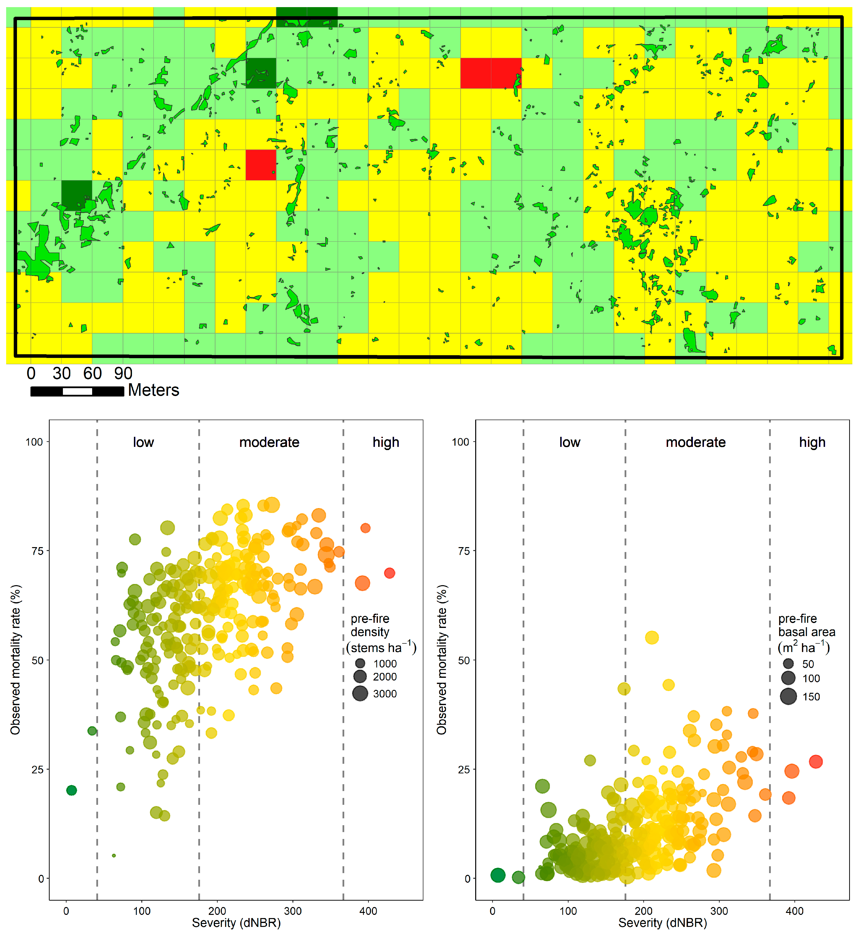
Figure 1.
Spatial variation in burn severity at multiple scales within the Yosemite Forest Dynamics Plot. The YFDP contains 238 contiguous Landsat pixels. There were 24,305 immediate fire mortalities, with 7408 trees surviving two years post-fire within these 238 Landsat pixels. Fire severity measured by the differenced Normalized Burn Ratio (dNBR) [11] (unchanged [dark green], <41; 41 ≤ low severity [light green] < 176; 176 ≤ moderate severity [yellow] < 367; high severity [red] ≥367). Patches of unburned ground surface ≥1 m2 (mapped six months post-fire) shown in medium green. One-year post-fire tree mortality per Landsat pixel by tree density and tree basal area is shown, but the relationship between dNBR spectral change does not have a simple correlation with observed mortality.


Table 1.
Background levels of mortality in the Yosemite Forest Dynamics Plots and immediate and delayed consequences of fire. The Rim Fire occurred in August–September 2013, and field sampling took place in May–June of each year. The 25.6 ha extent of the plot allows for statistically significant inference of the effects on sub-populations of concern, such as large-diameter trees.
| Diameter Class (cm) | Mortalities (Stems) | ||||||
|---|---|---|---|---|---|---|---|
| Pre-Fire | Fire | Post-Fire | |||||
| 2011 | 2012 | 2013 | 2014 | 2015 | 2016 | 2017 | |
| 1 cm ≤ dbh < 10 cm | 340 | 341 | 463 | 18,698 | 665 | 128 | 84 |
| 10 cm ≤ dbh < 30 cm | 173 | 145 | 121 | 5241 | 1644 | 540 | 273 |
| 30 cm ≤ dbh < 60 cm | 18 | 28 | 19 | 319 | 285 | 307 | 192 |
| 60 cm ≤ dbh < 90 cm | 6 | 7 | 6 | 23 | 27 | 87 | 56 |
| dbh ≥ 90 cm | 5 | 11 | 4 | 24 | 17 | 130 | 64 |
| Total | 542 | 532 | 613 | 24,305 | 2638 | 1192 | 669 |
© 2018 by the authors. Licensee MDPI, Basel, Switzerland. This article is an open access article distributed under the terms and conditions of the Creative Commons Attribution (CC BY) license (http://creativecommons.org/licenses/by/4.0/).
Share and Cite
MDPI and ACS Style
Lutz, J.A.; Larson, A.J.; Swanson, M.E. Advancing Fire Science with Large Forest Plots and a Long-Term Multidisciplinary Approach. Fire 2018, 1, 5. https://0-doi-org.brum.beds.ac.uk/10.3390/fire1010005
AMA Style
Lutz JA, Larson AJ, Swanson ME. Advancing Fire Science with Large Forest Plots and a Long-Term Multidisciplinary Approach. Fire. 2018; 1(1):5. https://0-doi-org.brum.beds.ac.uk/10.3390/fire1010005
Chicago/Turabian StyleLutz, James A., Andrew J. Larson, and Mark E. Swanson. 2018. "Advancing Fire Science with Large Forest Plots and a Long-Term Multidisciplinary Approach" Fire 1, no. 1: 5. https://0-doi-org.brum.beds.ac.uk/10.3390/fire1010005