Seismic Lines in Treed Boreal Peatlands as Analogs for Wildfire Fuel Modification Treatments


School of Geography and Earth Sciences, McMaster University, 1280 Main Street West, Hamilton, ON L8S 4K1, Canada
*
Author to whom correspondence should be addressed.
Fire 2020, 3(2), 21; https://0-doi-org.brum.beds.ac.uk/10.3390/fire3020021
Submission received: 8 April 2020
/
Revised: 22 May 2020
/
Accepted: 4 June 2020
/
Published: 6 June 2020
(This article belongs to the Special Issue Boreal Fire-Fuels Interactions)
Abstract
:Across the Boreal, there is an expansive wildland–society interface (WSI), where communities, infrastructure, and industry border natural ecosystems, exposing them to the impacts of natural disturbances, such as wildfire. Treed peatlands have previously received little attention with regard to wildfire management; however, their role in fire spread, and the contribution of peat smouldering to dangerous air pollution, have recently been highlighted. To help develop effective wildfire management techniques in treed peatlands, we use seismic line disturbance as an analog for peatland fuel modification treatments. To delineate below-ground hydrocarbon resources using seismic waves, seismic lines are created by removing above-ground (canopy) fuels using heavy machinery, forming linear disturbances through some treed peatlands. We found significant differences in moisture content and peat bulk density with depth between seismic line and undisturbed plots, where smouldering combustion potential was lower in seismic lines. Sphagnum mosses dominated seismic lines and canopy fuel load was reduced for up to 55 years compared to undisturbed peatlands. Sphagnum mosses had significantly lower smouldering potential than feather mosses (that dominate mature, undisturbed peatlands) in a laboratory drying experiment, suggesting that fuel modification treatments following a strategy based on seismic line analogs would be effective at reducing smouldering potential at the WSI, especially under increasing fire weather.
1. Introduction
Peatlands, which are wetlands that have accumulated at least 0.4 m of organic soil (peat) [1], occupy approximately 21% of the land area in continental western Canada [2]. In the Boreal Plains (BP) ecozone, peatland carbon dynamics are intrinsically tied to the wildfire regime through the combustion of peat [3] and post-fire ecosystem recovery [4,5]. Under the sub-humid climate of the BP, treed peatlands accumulate similar above-ground fuel loads to upland forests [6] and can influence fire spread and total area burned [7]. At ground level, there can be substantial variability in peat burn severity (0 m to >1 m, depth of burn (DOB)) depending on the complex interactions of above-ground fuel load [8], peat properties [9] and hydrological conditions [10]. As such, the associated emissions of smoke and particulate matter [11,12], mercury [13], and carbon [8,10] also vary within and among fires. With treed peatlands covering ~36% of the BP [14], and the abundance of communities, infrastructure, and industry in the region, a substantial wildland–society interface (WSI) with these ecosystems has developed. Increasingly, wildfire management is required to protect valuable assets at the WSI [15]; however, very few studies have examined fuel modification treatment approaches in boreal peatlands for wildfire management [16]. Research into novel treatments is required because traditional fuel modification treatments, e.g., [16], may not effectively reduce DOB or surface carbon loss and associated wildfire suppression efforts [17]. Seismic lines—linear disturbances where above-ground vegetation is removed, typically using heavy machinery, to enable the assessment of below-ground hydrocarbon resources via the reflection of seismic waves [18]—have recently been found to have application as fire-refugia, experiencing low peat burn severity, in the boreal forest [19]. Hence, the aim of this study is to examine the ecohydrological characteristics of seismic lines that intersect treed boreal peatlands, using this disturbance as an analog for fuel modification treatments to reduce peat smouldering potential at the WSI.
Wildfire management (e.g., the FireSmart program in Canada) may take the form of suppression efforts in the event of a fire, or proactive management practices such as fuel modification treatments. FireSmart treatments aim to reduce fire danger by decreasing the rate of spread and/or head fire intensity, while simultaneously enhancing suppression efforts within treated areas [20]. Whilst treed boreal peatlands can sustain high-intensity crown fires similar to upland stands [6], once ignited the below-ground peat burns primarily by smouldering combustion, a slow, flameless form of combustion, which can become self-propagating and requires long and sustained fire suppression efforts to extinguish [21]. Therefore, in treed boreal peatlands, fuel modification treatments for wildfire management should aim to reduce peat smouldering potential to enhance suppression efforts.
The hydrophysical properties of the peat, moisture content and bulk density, exert a first-order control on the likelihood of peat combustion since they represent the major energy sink and source, respectively, for the combustion reaction [9,22,23]. Moisture content is controlled by moss/peat moisture retention properties that vary between common peatland moss species [24], often leading to substantial spatial heterogeneity in peat burn severity [3]. For example, the presence of drought-resistant Sphagnum species, with strong water retention capabilities, generally leads to low burn severity in Sphagnum-dominated microforms (e.g., hummocks; [25]). Conversely, low density feather mosses [26], that can occupy both hollows and hummocks in peatlands, are more susceptible to desiccation and therefore greater combustion under drought conditions [27]. In addition to peat/moss moisture content, bulk density also exerts an important control on peat smouldering potential [9]. Although greater bulk density tends to increase the water retention of moss and peat [28,29,30], it also acts to increase fuel density and increase the moisture threshold at which peat combustion can occur [9,22].
As such, effective fuel modification treatments in treed peatlands must consider changes in both the above-ground and below-ground (peat) fuels. Fuel treatments, such as those adopted in FireSmart, primarily involve the removal, reduction, or conversion of on-site above-ground fuels [15,20]. One approach to assessing the suitability of potential peatland fuel modification treatments is to examine the ecohydrology of boreal peatland disturbances that affect both above- and below-ground fuels. A notable disturbance that may be considered an analog for post-treatment successional trajectories is seismic lines that intersect treed boreal peatlands in 1.5–10 m-wide lines [31]. In Alberta alone, at least 345,000 km of seismic lines intersect peatlands, affecting an area of more than 1900 km2 [32]. Although most predominantly discussed for their negative impact on Caribou habitat [33] and their increased greenhouse gas emissions compared to adjacent forests [32], they have recently been identified as important fire refugia for some plant and butterfly species [19]. In addition to the removal of above-ground vegetation and subsequent reduction in canopy fuel load, heavy machinery has been shown to compress the peatland surface and reduce microtopographic variability [34,35]. In addition to the impact on peat hydrophysical properties (e.g., [36]), peat compression causes an increase in near-surface bulk density, which may further hinder the regeneration of vegetation by decreasing soil aeration and restricting root penetration [37].
Vegetation recovery within seismic lines has been found to be substantially delayed compared to other peatland disturbances (e.g., wildfire; [38]). Significant signs of vegetation recovery are unlikely even 35 years post-disturbance in bogs [34,39,40]. In addition to a long-term reduction in the tree canopy, seismic line width, as well as orientation, affects the amount of incoming solar radiation [40], which may have implications for evaporation rates, surface moisture and vegetation recovery. Moreover, whilst Sphagnum mosses are competitively excluded by feather mosses under shaded conditions [41], it is likely that tree removal provides a competitive advantage for fire-resistant Sphagnum mosses [42] within seismic lines. Such changes within treed peatlands may have utility in the context of wildfire management by representing analogs for novel fuel modification strategies aimed at reducing peat smouldering potential; however, research on this strategy has not previously been examined. Reducing peat smouldering potential and enhancing wildfire suppression efforts in treed peatlands is most important in areas where wildfire management by prescribed burning is logistically complicated or unattainable, and a reduction in smoke emission (due to smouldering fires) is a priority. In the BP, such areas will be designated for FireSmart treatment, and are typically at the WSI, where peatlands are directly adjacent to industry, infrastructure or communities [20].
2. Methods
2.1. Site Selection
All sites are located within the Central Mixedwood Natural Subregion of Canada’s Boreal Plains, in proximity to the town of Wabasca, AB. The landscape of this region consists of a mosaic of aspen, mixedwood, and white spruce forested upland regions surrounding abundant wetlands, predominantly bogs and fens [14]. Sites were classified as treed bogs (see [43]), where black spruce (Picea mariana) is the dominant tree species. Sphagnum mosses often dominate the ground cover; however, feather mosses and lichens (e.g., Caldina spp.) encroach over Sphagnum in later succession [43,44]. Research sites were identified using historical aerial imagery [45], which allowed us to locate and approximate the year of seismic line establishment (Table 1). Efforts to reduce the environmental impacts of seismic lines have seen a reduction in line widths from legacy seismic lines (5–10 m), to low-impact seismic lines (1.5–5 m) since the mid-1990s [18]. Whilst vegetation clearing occurs in the winter months when the ground is frozen in an attempt to reduce soil/peat disturbance [18,31,34], heavy machinery is still utilized in the creation of low-impact seismic lines [18]. Hence, seismic lines established in a range of decades are included in this study.
2.2. Research Design
Three parallel transects, each 15 m in length, were established at each site (n = 6). One transect was established within the seismic line and the remaining two transects were established in the treed portions of the peatland on opposite sides of the seismic line, hereafter referred to as the “adjacent peatland”. Adjacent peatland transects were located at least 4 m away from the edge of the seismic line in order to minimize edge effects that are most impactful in the first 4 m [46]. Ground layer vegetation plots were delineated using quadrats measuring 0.6 m by 0.6 m, within which ground cover and shrub cover were assessed at 1 m intervals along the transects. Near-surface volumetric moisture content (VWC) (0–0.06 m) was measured for the most abundant ground cover type within each quadrat using an ML3 ThetaProbe (Delta-T Devices, Burwell, Cambridge, United Kingdom). All field measurements were taken between 23 and 26 May 2018, where no precipitation events were recorded during this time period.
At each site, a polyvinyl chloride (PVC) pipe (0.6 m length × 0.08 m inside diameter) was used to extract one core from within the seismic line and one from a randomly selected transect in the adjacent peatland. Cores were frozen prior to analysis and were cut longitudinally into two equal halves to reveal the peat profile within the top 0.6 m at each site. Cores were then dissected in 0.02 m intervals and dried at 85 °C until no change in sample mass was observed in order to calculate the sample bulk density. Samples were further dissected to quantify the dry weight of wood within each 0.02 m interval. Black spruce was the dominant tree species found at each site and therefore; it was assumed that woody material within each sample was of black spruce origin. The bulk density (440 kg m−3 [47]) of black spruce was applied to calculate the volume of sample occupied by the woody material; from this, calculations of peat bulk density were made.
2.3. Canopy Gap Fraction
Canopy photographs were captured above each quadrat from a height of 0.5 m using a Sony Cyber-shot WX350 digital camera. RGB data were used to classify image pixels as vegetation or sky. Pixels with a low intensity (Itotal = R + B + G) and low blue index (IB = B/Itotal), or a high green index (IG = (2 × G − R − B)/(2 × G + R + B)) were classified as vegetation using visually optimized thresholds derived from a subset of plot images. Canopy gap fraction was calculated based on the proportion of vegetation-classified pixels using unweighted pixel counts. Canopy gap fraction values were averaged across plot locations to provide a mean canopy gap fraction value for the seismic line and either side of the adjacent peatland at each site.
2.4. Smouldering Potential
In order to estimate the smouldering potential of near-surface (0–0.06 m) moss and peat, an energy balance model from [9] was adapted to evaluate the relative vulnerability of moss/near-surface peat within seismic lines and the adjacent peatland to smouldering combustion. Other studies have successfully applied this approach to estimate and model peat vulnerability to ignition and smouldering combustion [10,48]. Smouldering potential is estimated based on the quotient of energy released during combustion (Hcomb) to the energy required to ignite (Hign) fuels, i.e., Hcomb/Hign, in adjacent fuel layers (i). The amount of energy released during peat combustion is defined as:
where is the bulk density (kg m−3), x is the thickness of the fuel layer (0.06 m in this study), and Ecomb (14.2 J kg−1 for milled peat from [49]) is the low heat of combustion per unit mass of peat. The amount of energy required for ignition is defined as:
where h (J kg−1 fuel) is the heat of ignition for the fuel horizon and can be expressed simply using m, where m is the gravimetric water content of the fuel layer ([9], Equation (6)):
There is potential for combustion when Hcomb/Hign = 1; however, energy from fuel combustion is emitted in all directions, and therefore, fuels are likely to require an Hcomb/Hign quotient greater than 1 for combustion to occur. Hcomb/Hign quotients were evaluated for seismic lines and adjacent peatlands using bulk density from cores and moisture content measured along transects.
To examine the potential role of species-specific differences in moisture retention on Hcomb/Hign quotients during dry periods, we also undertook a drying experiment in the lab. Smouldering potential was calculated for the top 0.06 m of 0.4 m deep Sphagnum and feather moss samples (n = 6) that underwent a period of drying (45–50 days) in a laboratory setting (temperature = 23.1 ± 3.20 °C, relative humidity = 59.8 ± 13.4%), VWC measurements (n = 3 per sample) were taken at the end of the drying period where average WTD was 0.29 and 0.22 m in Sphagnum and feather moss samples, respectively. Similar to field samples, the bulk density of the top 0.06 m was calculated following oven drying at 85 °C until samples reached constant mass.
2.5. Statistical Analyses
All statistical analyses were performed using RStudio version 1.1.463 [50]. The three transects at each site were compared for differences in canopy gap fraction, ground cover composition, shrub cover, VWC, and smouldering potential. In general, data were not normally distributed, and hence, Kruskal–Wallis (KW) tests for multiple comparisons were coupled with Fisher’s least significant difference (LSD) post hoc tests and the Benjamini–Hochberg method was used to account for multiple comparisons [51]. Χ2 test statistics are summarised in Table S1. Peat bulk density was compared between adjacent 0.02 m increments using Mann–Whitney U tests, and test statistics are summarised in Table S2.
3. Results
3.1. Vegetation
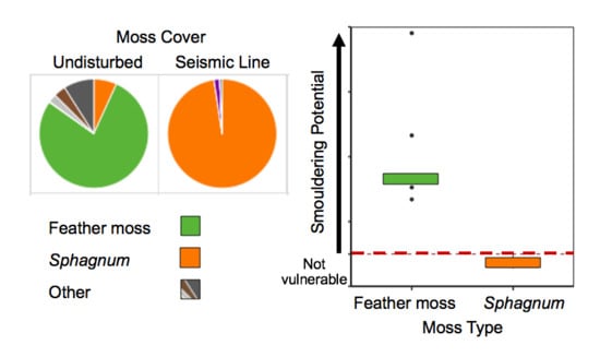
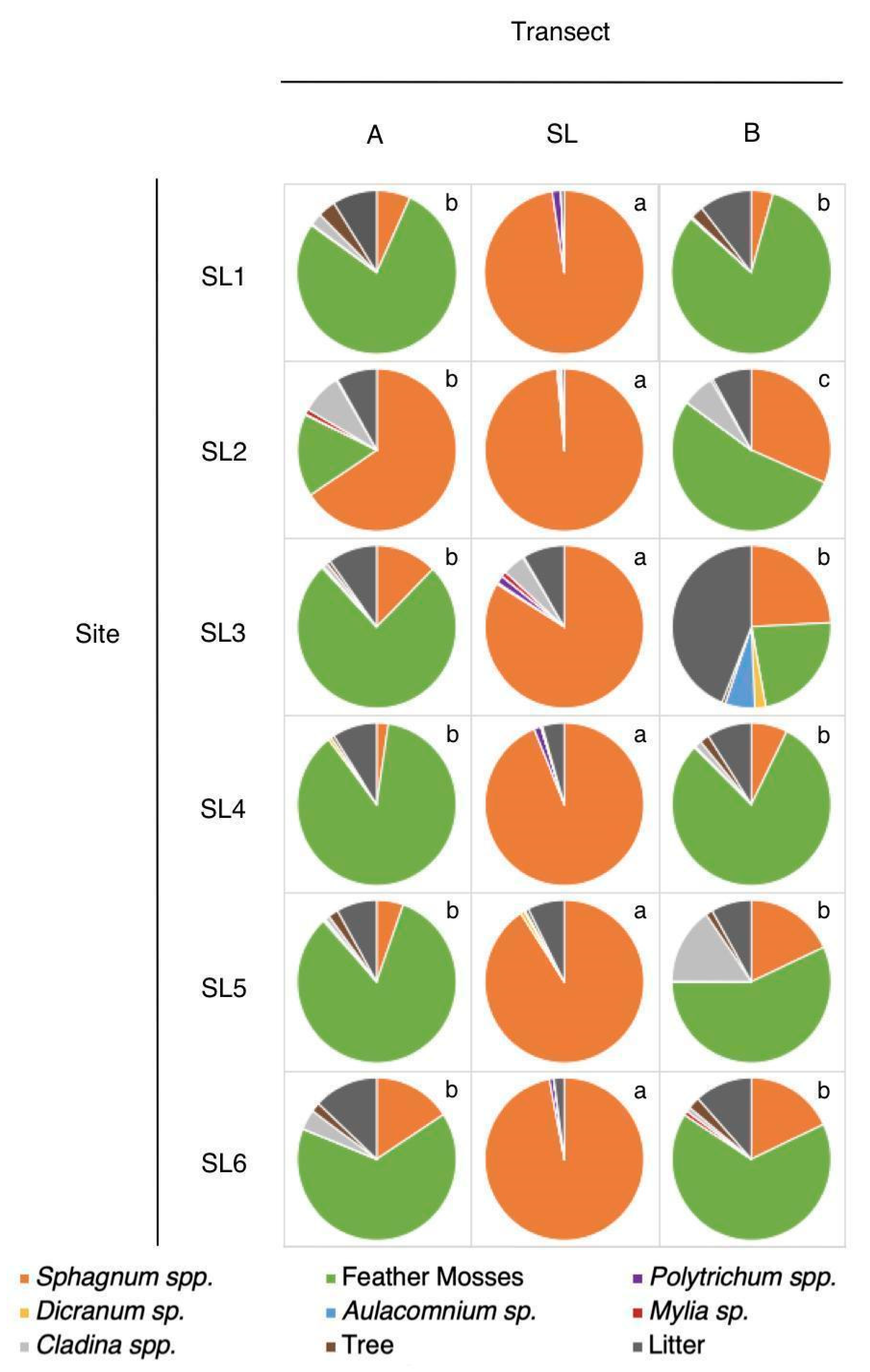
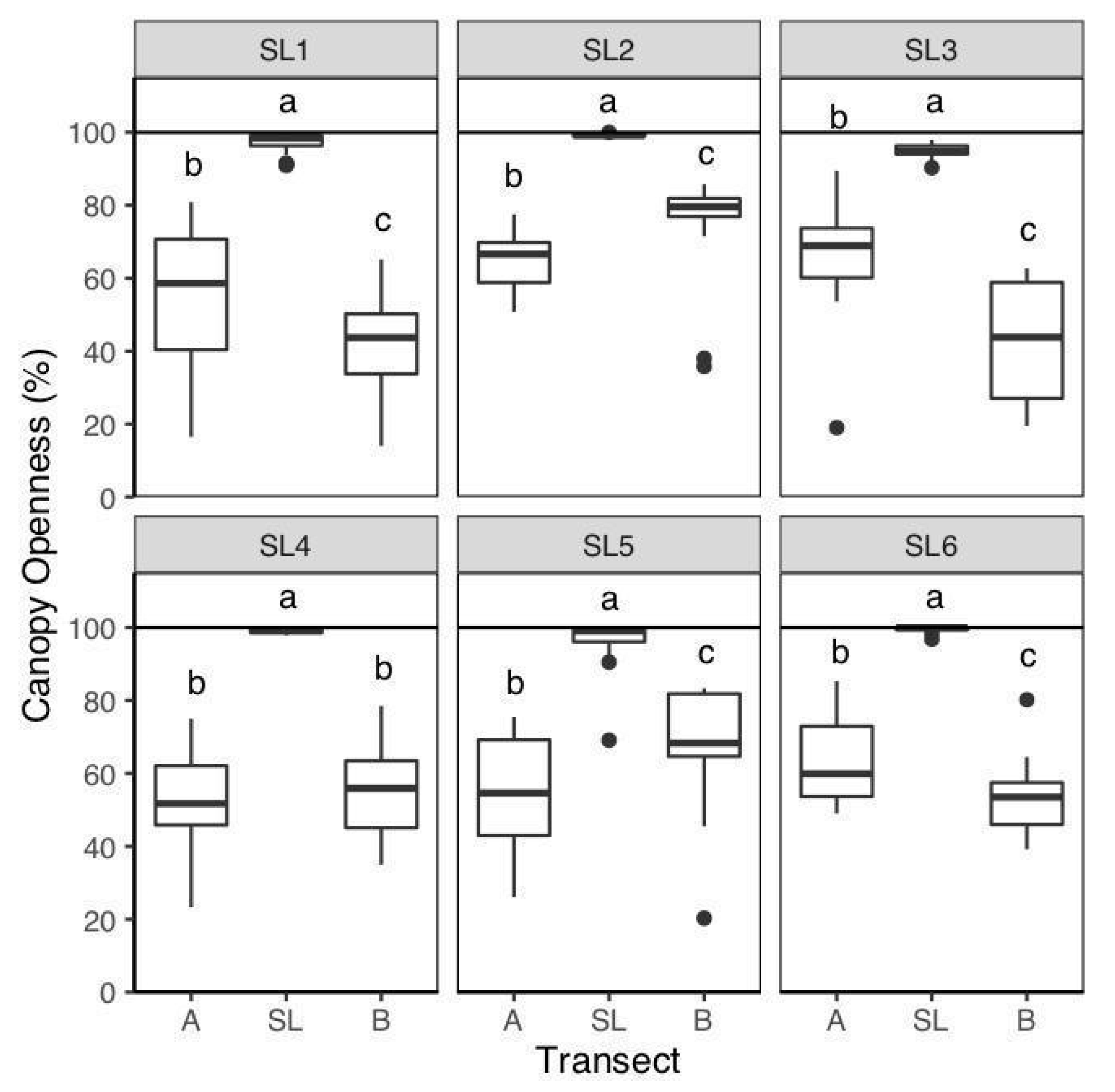
Sphagnum moss was the dominant ground cover within seismic lines where mean cover was 91–99% (Figure 1). Sphagnum percent cover was significantly greater in seismic lines relative to the adjacent peatland transects (mean cover 4–66%) (p < 0.01; Table S1). Feather moss was typically the dominant ground cover in adjacent peatland transects with mean cover of up to 87%, whereas feather moss was never present in seismic line transects (Figure 1). Lichen cover tended to be low (<5%), but greater in the adjacent peatland than in the seismic line (Figure 1), whereas shrub cover was not significantly different between most transects (p > 0.05; Table S1). Canopy gap fraction was greater within the seismic line compared to the adjacent peatland (p < 0.01; Table S1), where mean seismic line openness was >95% and adjacent peatland transects were <80% (Figure 2). Notably, at five of the six sites, canopy gap fraction was significantly different between portions of the peatland on either side of the seismic line (Figure 2).
3.2. Volumetric Water Content
Mean near-surface (0–0.06 m) seismic line VWC (29.5 ± 18.3%) was significantly greater than in the adjacent peatland transects (7.97 ± 7.29%) (Χ2 = 142.2; p < 0.01). Five of the six sites show significantly greater VWC within the seismic line relative to both adjacent peatland transects (p < 0.01; Table S1), while SL6 shows only significant differences between the seismic line (15.6 ± 7.0%) and eastern portion (11.2 ± 10.1%), but not the western portion (11.5 ± 9.8%) of the peatland (Figure 3, Table S1).
3.3. Peat Properties
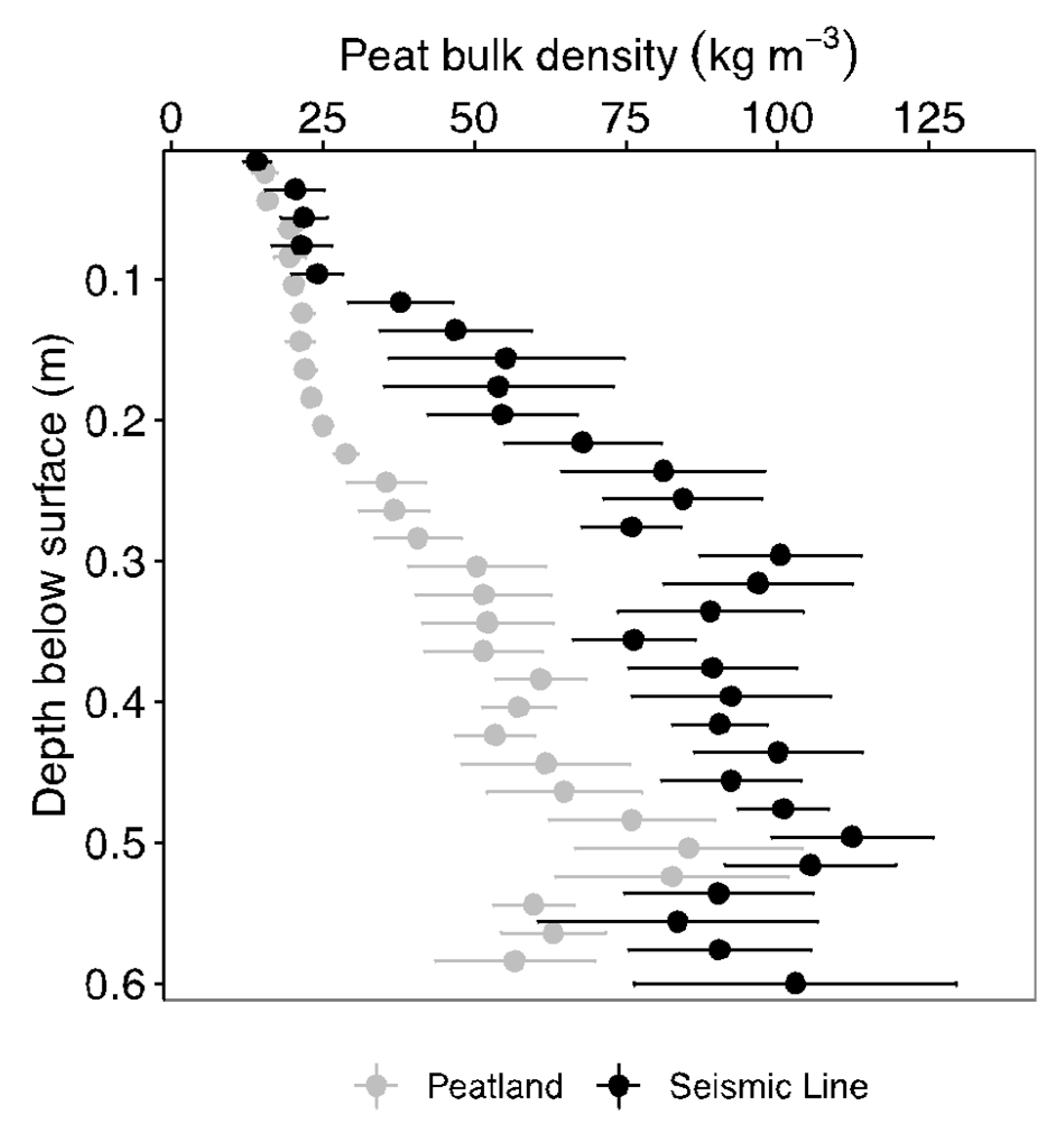
Peat bulk density was not significantly different (p > 0.05, Table S2) between seismic line and peatland cores in the 0.02 m depth increments between 0 and 0.14 m (Figure 4). However, a subsequent layer between 0.14 and 0.22 m below the surface showed instances where seismic line peat was significantly denser than the adjacent peatland, and an underlying layer from 0.22 to 0.32 m showed greater average bulk density of seismic line peat compared to the adjacent peatland. Peat bulk densities below this depth are, in general, not significantly different between the seismic line and adjacent peatland (p > 0.05; Table S2); however, bulk density with depth varies for each site specifically (Figure S1). Visual examination of the peat cores showed disconformities in seismic line cores that correspond with the layers of increased bulk density compared to peatland cores, which are generally characterized by more gradual transitions from surface moss to increasing stages of decomposed peat (Figure S2).
3.4. Smouldering Potential
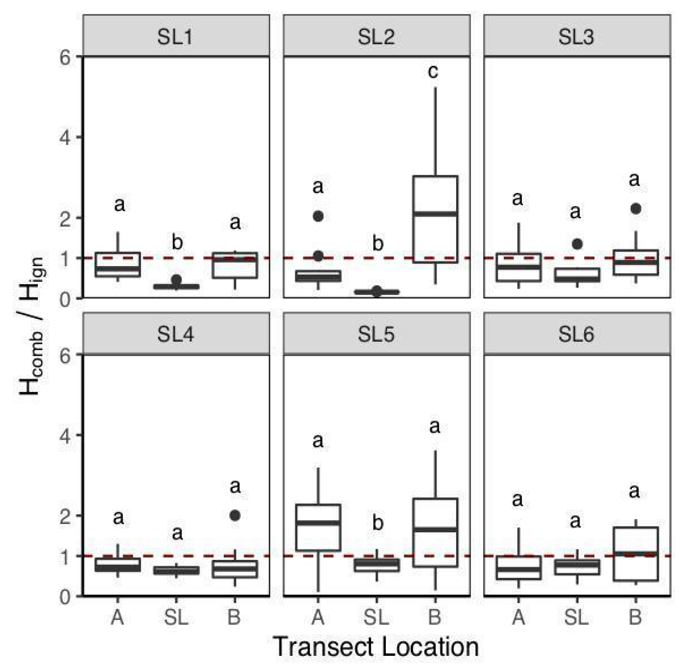
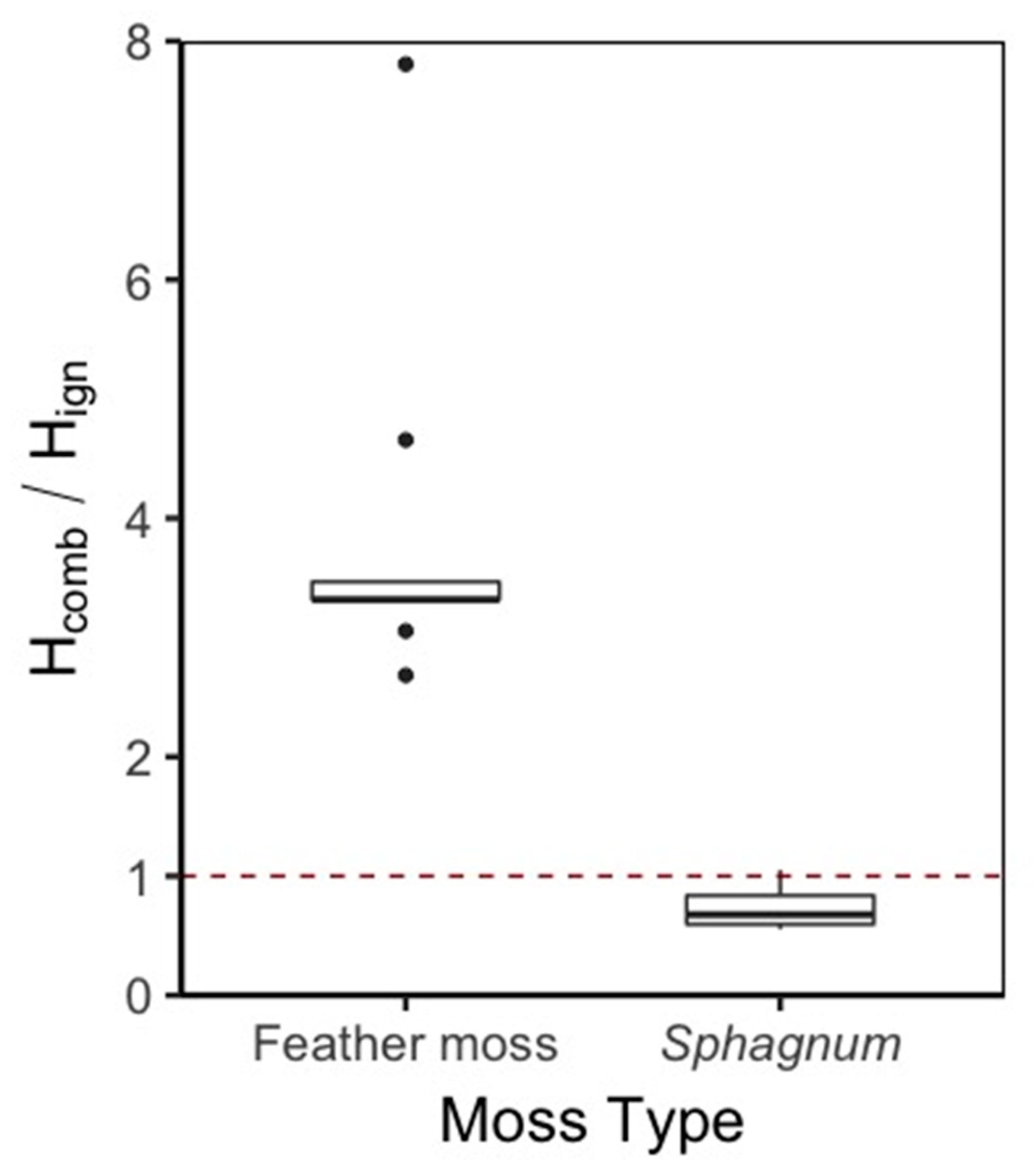
Field measurements found that average Hign/Hcomb (i.e., smouldering potential) was significantly different between seismic lines and adjacent peatlands (Χ2 = 55.02, p < 0.01). Median smouldering potential in all seismic lines was <1 whilst in adjacent peatlands was sometimes > 1 (Figure 5). On a per site basis, smouldering potential was significantly lower (p < 0.01; Table S1) in seismic lines compared to adjacent peatland transects at three of the six sites using field moisture contents (Figure 5). Notably, these included sites with wider seismic lines (SL1 and SL5). The results from our lab experiment indicate that under dry conditions, Sphagnum samples maintain no to low smouldering potential (median = 0.70), whereas feather moss samples had significantly higher smouldering potential (median = 4.10) (t1 = 12.92; p < 0.01) (Figure 6).
4. Discussion
Seismic lines contained a significantly greater percentage of Sphagnum moss ground cover relative to the adjacent treed portions of the peatland, where mean cover in the seismic lines was 91–99% (Figure 1). The significantly greater canopy openness of seismic lines relative to the adjacent peatland (Figure 2) confirms previous reports of delayed vegetation recovery in these areas [34,52], even 55 years after disturbance (Table 1). This demonstrates reduced canopy fuel loads on seismic lines that intersect treed peatlands, and since feather mosses generally outcompete Sphagnum mosses under low light (shaded) conditions, increasing canopy openness by tree removal reduces the competitive advantage of feather mosses over Sphagnum [41,42]. Sphagnum species have exceptional moisture retention capabilities [24], that are likely responsible for the significantly greater moisture contents in the near-surface (0–0.06 m) in the seismic lines compared to the adjacent peatland transects (Figure 3).
The persistence of these changes to vegetation composition suggests that seismic line establishment may alter fundamental ecosystem processes, such as the hydrological connectivity or the hydrologic pathways of the seismic lines [40]. Due to the potential redistribution of water, some studies have found increased flooding on seismic lines intersecting peatlands and suggest this as a potential compounding factor in poor vegetation recovery [53]. Additionally, peat compression and the associated increased bulk density between 0.14 and 0.32 m below the surface (Figure 4) induced through heavy machinery use in seismic line establishment (55–18 years before the study) likely increased the moisture retention capabilities of peat [28] and vertical transport of water to the ground surface [36] (Figure 3). Nonetheless, more water being directed to, or retained in, the peat in the seismic line may have further created conditions more favourable for the growth of Sphagnum mosses as opposed to feather mosses, as feather mosses generally thrive at least 0.3 m above the average water table position [41].
The rapid expansion of Sphagnum has been found to be detrimental to the establishment of tree saplings [37,53]. As such, in seismic lines, Sphagnum mosses may have created a positive feedback whereby their expansion actively limits tree growth and therefore maintains a high canopy gap fraction, which is beneficial to their productivity. Since tree removal (increasing canopy gap fraction) alone does not cause significant changes to Sphagnum and feather moss percent cover over medium timescales (4 years; [54]) it is likely that the combination of alterations to the above- and below-ground environment, and the associated hydrological impacts, enables Sphagnum to propagate and thrive. Hence, we attribute the top ~0.14 m of peat in seismic lines, with a bulk density that is not significantly different to the adjacent peatland (Figure 4, Table S2), to new growth since seismic line establishment (~0.015 m/yr; [55]).
Corresponding to the significantly greater near-surface VWC of moss/peat in the seismic line compared to that in the adjacent peatland (Figure 3), smouldering potential (Hcomb/Hign) was always below 1 in the seismic line, whereas this was not the case in the adjacent peatland (Figure 5). Consistent Hcomb/Hign of less than 1 (i.e., no to low smouldering combustion potential) supports research indicating that seismic lines intersecting treed peatlands are resistant to high peat burn severity [19], likely due to their high percent cover of Sphagnum mosses (Figure 1), similar to [3,25], and high moisture contents (Figure 3 and Figure 6). Using field measurements of VWC (taken between 23 and 26 May 2018), half of the sites showed significantly lower smouldering potential in the seismic line compared to either side of the adjacent peatland, however, smouldering potential was relatively low in some of the peatland plots (Figure 5). This supports research findings that show that peatlands are generally considered resistant to high severity peat burn [25;44] due to their ability to maintain a near-surface water table [56]. However, under climatic extremes (e.g., droughts; [10]), and in prolonged water deficit scenarios (e.g., in the Boreal Plains; [57]) such resistance can become overwhelmed, resulting in water table drawdown and surface drying, increasing the smouldering potential of near-surface peat [10,57].
As drought periods in the region become both more common and intense under future climatic scenarios [58] and fire weather increases [59], the disparity in smouldering potential between seismic lines and adjacent peatlands is expected to become more prevalent (Figure 6). This is supported by the difference in smouldering potential of Sphagnum and feather moss from our drying experiment, where median smouldering potential for Sphagnum samples was maintained at <1 after an extended (7 week) dry period, whereas feather moss samples had a median smouldering potential of ~4, indicating substantial vulnerability to smouldering (Figure 6). Given that the areas of peatland adjacent to the seismic line were feather moss dominated and the seismic lines were Sphagnum-dominated (up to 91–99%; Figure 1), we would expect the overall smouldering potential of each area to reflect its respective dominant moss type. This supports the evidence of lower burn severity on seismic lines compared to adjacent peatlands after a wildfire in extreme fire weather (i.e., the Fort McMurray Horse River wildfire, 2018; [19]).
Wildfire Management Applications
The results of this study provide insights into the development of potential novel fuel modification treatments in treed boreal peatlands. Seismic line disturbance has proved a useful analog for fuel modification treatments that address both above- and below-ground fuels. The removal of canopy fuels reduces the fuel available for consumption in a crown fire, acting to reduce head fire intensity and potentially slowing the rate of spread [16], addressing two key aims of FireSmart treatments currently being implemented by the Alberta Ministry of Agriculture and Forestry [20]. The reduction in smouldering potential would aid wildfire suppression efforts and could reduce peat carbon loss. The management of future fuel load could be considered by burning downed fuels on-site during the winter months, rather than mulching or chipping, which can increase surface carbon loss during fires in treed boreal peatlands (e.g., [17]). Further considerations should include the potential changes to carbon fluxes of the treated areas [32] and possible effects on forest fauna where applicable (e.g., [33]).
Moreover, this research identifies a strategy for propagating Sphagnum mosses on the boreal landscape that reduces peat smouldering potential compared to feather mosses under drought conditions (Figure 6). We believe this may be especially beneficial at the WSI (e.g., in treed peatlands directly adjacent to communities; [60]) where traditional FireSmart treatments are already being implemented and where there are concerns about high severity peat burns and the associated detrimental effects on air quality. The combination of changes to the above- and below-ground environment results in a persistent change in species composition, fuel load, and smouldering potential that is likely more prominent under high fire weather indices. We argue that this “open and compress” strategy should be tested in treed boreal peatlands at the WSI, where FireSmart treatments are designated, with the aim of enhancing fire suppression efforts. Future research should test the degree of canopy openness and compression required to propagate combustion-resistant Sphagnum mosses in treed boreal peatlands and thereby reduce peat smouldering potential with minimal impact on landscape aesthetics and structure.
Supplementary Materials
The following are available online at https://0-www-mdpi-com.brum.beds.ac.uk/2571-6255/3/2/21/s1, Figure S1: Peat bulk density with depth, Figure S2: Photographs of peat profiles, Table S1: Summary of multiple comparison tests, Table S2: Summary of peat bulk density.
Author Contributions
Research design was conducted collectively by all authors. P.J.D. completed field and lab work with the assistance of S.L.W. Writing and analysis was completed by P.J.D. with assistance and editing from S.L.W., P.A.M. and J.M.W. All authors have read and agreed to the published version of the manuscript.
Acknowledgments
The authors would like to thank Greg Verkaik and Ryan Threndyle for assistance in the field and lab, and Kristyn Mayner and Craig Allison for prior work on site selection. We would also like to thank Dan Thompson for his constructive comments and the two anonymous reviewers of this manuscript. This research was supported by the Boreal Water Futures project led by JMW and funded by the Global Water Futures program, Canada First Research Excellence Fund.
Conflicts of Interest
The authors report no conflict of interest.
References
- National Working Wetlands Group. The Canadian Wetland Classification System, 2nd ed.; Environment Canada: Ottawa, ON, Canada, 1997; p. 68.
- Vitt, D.H.; Halsey, L.A.; Bauer, I.E.; Campbell, C. Spatial and temporal trends in carbon storage of peatlands of continental western Canada through the Holocene. Can. J. Earth Sci. 2000, 37, 683–693. [Google Scholar] [CrossRef]
- Benscoter, B.; Wieder, R.K. Variability in organic matter lost by combustion in a boreal bog during the 2001 Chisholm fire. Can. J. For. Res. 2003, 33, 2509–2513. [Google Scholar] [CrossRef]
- Ingram, R.; Moore, P.; Wilkinson, S.L.; Petrone, R.; Waddington, J.M. Postfire Soil Carbon Accumulation Does Not Recover Boreal Peatland Combustion Loss in Some Hydrogeological Settings. J. Geophys. Res. Biogeosci. 2019, 124, 775–788. [Google Scholar] [CrossRef]
- Wieder, R.K.; Scott, K.D.; Kamminga, K.; Vile, M.A.; Vitt, D.H.; Bone, T.; Xu, B.; Benscoter, B.; Bhatti, J.S. Postfire carbon balance in boreal bogs of Alberta, Canada. Glob. Chang. Biol. 2009, 15, 63–81. [Google Scholar] [CrossRef]
- Thompson, D.K.; Parisien, M.-A.; Morin, J.; Millard, K.; Larsen, C.; Simpson, B. Fuel accumulation in a high-frequency boreal wildfire regime: From wetland to upland. Can. J. For. Res. 2017, 47, 957–964. [Google Scholar] [CrossRef] [Green Version]
- Thompson, D.K.; Simpson, B.N.; Whitman, E.; Barber, Q.E.; Parisien, M.-A. Peatland Hydrological Dynamics as A Driver of Landscape Connectivity and Fire Activity in the Boreal Plain of Canada. Forests 2019, 10, 534. [Google Scholar] [CrossRef] [Green Version]
- Wilkinson, S.L.; Moore, P.A.; Flannigan, M.D.; Wotton, B.M.; Waddington, J.M. Did enhanced afforestation cause high severity peat burn in the Fort McMurray Horse River wildfire? Env. Res. Lett. 2018, 13, 014018. [Google Scholar] [CrossRef]
- Benscoter, B.; Thompson, D.K.; Waddington, J.M.; Flannigan, M.; Wotton, B.M.; De Groot, W.J.; Turetsky, M.R. Interactive effects of vegetation, soil moisture and bulk density on depth of burning of thick organic soils. Int. J. Wildland Fire 2011, 20, 418–429. [Google Scholar] [CrossRef] [Green Version]
- Lukenbach, M.C.; Hokanson, K.; Moore, P.A.; DeVito, K.; Kettridge, N.; Thompson, D.K.; Wotton, B.M.; Petrone, R.; Waddington, J.M. Hydrological controls on deep burning in a northern forested peatland. Hydrol. Process. 2015, 29, 4114–4124. [Google Scholar] [CrossRef]
- Shaposhnikov, D.; Revich, B.; Bellander, T.; Bedada, G.B.; Bottai, M.; Kharkova, T.; Kvasha, E.; Lezina, E.; Lind, T.; Semutnikova, E.; et al. Mortality Related to Air Pollution with the Moscow Heat Wave and Wildfire of 2010. Epidemiology 2014, 25, 359–364. [Google Scholar] [CrossRef] [Green Version]
- Hayasaka, H.; Noguchi, I.; Putra, E.I.; Yulianti, N.; Vadrevu, K. Peat-fire-related air pollution in Central Kalimantan, Indonesia. Environ. Pollut. 2014, 195, 257–266. [Google Scholar] [CrossRef] [PubMed]
- Turetsky, M.R.; Harden, J.; Friedli, H.R.; Flannigan, M.; Payne, N.; Crock, J.; Radke, L.; Flannigan, M. Wildfires threaten mercury stocks in northern soils. Geophys. Res. Lett. 2006, 33, 16. [Google Scholar] [CrossRef] [Green Version]
- Tarnocai, C.; Kettles, I.M.; Lacelle, B. Peatlands of Canada. Available online: https://0-doi-org.brum.beds.ac.uk/10.4095/288786 (accessed on 20 March 2020).
- Mooney, C. Fuelbreak Effectiveness in Canada’s Boreal Forests: A Synthesis of Current Knowledge; FPInnovations: Kitchner, ON, Canada, 2010; p. 16. [Google Scholar]
- Hvenegaard, S.; Schroeder, D.; Thompson, D. Fire Behaviour in Black Spruce Forest Fuels Following Mulch Fuel Treatments: A Case Study at Red Earth Creek, Alberta; FPInnovations: Edmonton, AB, Canada, 2016. [Google Scholar]
- Wilkinson, S.; Moore, P.; Thompson, D.K.; Wotton, B.M.; Hvenegaard, S.; Schroeder, D.; Waddington, J.M. The effects of black spruce fuel management on surface fuel condition and peat burn severity in an experimental fire. Can. J. For. Res. 2018, 48, 1433–1440. [Google Scholar] [CrossRef]
- Dabros, A.; Pyper, M.; Castilla, G. Seismic lines in the boreal and arctic ecosystems of North America: Environmental impacts, challenges, and opportunities. Environ. Rev. 2018, 26, 214–229. [Google Scholar] [CrossRef] [Green Version]
- Riva, F.; Pinzon, J.; Acorn, J.H.; Nielsen, S.E. Composite Effects of Cutlines and Wildfire Result in Fire Refuges for Plants and Butterflies in Boreal Treed Peatlands. Ecosystems 2019, 23, 485–497. [Google Scholar] [CrossRef]
- Partners in Protection. FireSmart: Protecting Your Community from Wildfire, 2nd ed.; Maryhelen Vicars: Edmonton, AB, Canada, 2003; p. 183. [Google Scholar]
- Rein, G.; Cleaver, N.; Ashton, C.; Pironi, P.; Torero, J. The severity of smouldering peat fires and damage to the forest soil. Catena 2008, 74, 304–309. [Google Scholar] [CrossRef] [Green Version]
- Frandsen, W.H. The influence of moisture and mineral soil on the combustion limits of smoldering forest duff. Can. J. For. Res. 1987, 17, 1540–1544. [Google Scholar] [CrossRef]
- Miyanishi, K.; Johnson, E.A. Process and patterns of duff consumption in the mixedwood boreal forest. Can. J. For. Res. 2002, 32, 1285–1295. [Google Scholar] [CrossRef]
- McCarter, C.; Price, J.S. Ecohydrology of Sphagnum moss hummocks: Mechanisms of capitula water supply and simulated effects of evaporation. Ecohydrology 2012, 7, 33–44. [Google Scholar] [CrossRef]
- Shetler, G.; Turetsky, M.R.; Kane, E.; Kasischke, E. Sphagnum mosses limit total carbon consumption during fire in Alaskan black spruce forests. Can. J. For. Res. 2008, 38, 2328–2336. [Google Scholar] [CrossRef] [Green Version]
- Busby, J.R.; Bliss, L.C.; Hamilton, C.D. Microclimate Control of Growth Rates and Habitats of the Boreal Forest Mosses, Tomenthypnum nitens and Hylocomium splendens. Ecol. Monogr. 1978, 48, 95–110. [Google Scholar] [CrossRef]
- Thompson, D.K.; Wotton, B.M.; Waddington, J.M. Estimating the heat transfer to an organic soil surface during crown fire. Int. J. Wildland Fire 2015, 24, 120–129. [Google Scholar] [CrossRef]
- Boelter, D.H. Physical Properties of Peats as Related to Degree of Decomposition. Soil Sci. Soc. Am. J. 1969, 33, 606–609. [Google Scholar] [CrossRef]
- Thompson, D.K.; Waddington, J.M. Peat properties and water retention in boreal forested peatlands subject to wildfire. Water Resour. Res. 2013, 49, 3651–3658. [Google Scholar] [CrossRef]
- Moore, P.; Morris, P.J.; Waddington, J.M. Multi-decadal water table manipulation alters peatland hydraulic structure and moisture retention. Hydrol. Process. 2015, 29, 2970–2982. [Google Scholar] [CrossRef]
- Timoney, K.; Lee, P. Environmental management in resource-rich Alberta, Canada: First world jurisdiction, third world analogue? J. Environ. Manag. 2001, 63, 387–405. [Google Scholar] [CrossRef]
- Strack, M.; Hayne, S.; Lovitt, J.; McDermid, G.J.; Rahman, M.M.; Saraswati, S.; Xu, B. Petroleum exploration increases methane emissions from northern peatlands. Nat. Commun. 2019, 10, 2804. [Google Scholar] [CrossRef] [Green Version]
- McLoughlin, P.D.; Dzus, E.; Wynes, B.; Boutin, S. Declines in Populations of Woodland Caribou. J. Wildl. Manag. 2003, 67, 755. [Google Scholar] [CrossRef]
- Lee, P.; Boutin, S. Persistence and developmental transition of wide seismic lines in the western Boreal Plains of Canada. J. Environ. Manag. 2006, 78, 240–250. [Google Scholar] [CrossRef]
- Lovitt, J.; Rahman, M.M.; Saraswati, S.; McDermid, G.J.; Strack, M.; Xu, B. UAV Remote Sensing Can Reveal the Effects of Low-Impact Seismic Lines on Surface Morphology, Hydrology, and Methane (CH4) Release in a Boreal Treed Bog. J. Geophys. Res. Biogeosci. 2018, 123, 1117–1129. [Google Scholar] [CrossRef] [Green Version]
- Golubev, V.; Whittington, P. Effects of volume change on the unsaturated hydraulic conductivity of Sphagnum moss. J. Hydrol. 2018, 559, 884–894. [Google Scholar] [CrossRef]
- Startsev, A.D.; McNabb, D. Effects of compaction on aeration and morphology of boreal forest soils in Alberta, Canada. Can. J. Soil Sci. 2009, 89, 45–56. [Google Scholar] [CrossRef]
- Johnston, D.; Turetsky, M.R.; Benscoter, B.; Wotton, B. Fuel load, structure, and potential fire behaviour in black spruce bogs. Can. J. For. Res. 2015, 45, 888–899. [Google Scholar] [CrossRef]
- Bayne, E.; Landau, H.; Tigner, J. Ecologically-Based Criteria to Assess the Impact and Recovery of Seismic Lines: The Importance of Width, Regeneration and Seismic Line Density; Environmental Studies Research Funds: Edmonton, AB, Canada, 2011. [Google Scholar]
- Revel, R.D.; Dougherty, T.D.; Downing, D.J. Forest Growth and Revegetation along Seismic Lines; U.S. Dept. of Energy: Oak Ridge, TN, USA, 1984.
- Bisbee, K.E.; Gower, S.T.; Norman, J.M.; Nordheim, E.V. Environmental controls on ground cover species composition and productivity in a boreal black spruce forest. Oecologia 2001, 129, 261–270. [Google Scholar] [CrossRef] [PubMed]
- Zhu, X.; Nimmo, V.; Wu, J.; Thomas, R. Sphagnum outcompetes feathermosses in their photosynthetic adaptation to postharvest black spruce forests. Botany 2019, 97, 585–597. [Google Scholar] [CrossRef]
- Mayner, K.M.; Moore, P.; Wilkinson, S.L.; Petrone, R.; Waddington, J.M. Delineating boreal plains bog margin ecotones across hydrogeological settings for wildfire risk management. Wetl. Ecol. Manag. 2018, 26, 1037–1046. [Google Scholar] [CrossRef]
- Benscoter, B.; Vitt, D.H. Spatial Patterns and Temporal Trajectories of the Bog Ground Layer Along a Post-Fire Chronosequence. Ecosystems 2008, 11, 1054–1064. [Google Scholar] [CrossRef]
- Alberta Environment and Parks. Air Photo Distribution Centre. Minister of Environment and Parks, Government of Alberta, Canada. 2016. Available online: http://aep.alberta.ca/forms-maps-services/air-photos/default.aspx (accessed on 10 April 2016).
- Hylander, K. Aspect modifies the magnitude of edge effects on bryophyte growth in boreal forests. J. Appl. Ecol. 2005, 42, 518–525. [Google Scholar] [CrossRef]
- Forintek Canada Corporation. Black Spruce, Alberta Facts on Wood Series; Forintek Canada Corp.: Vancouver, BC, Canada, 2006. [Google Scholar]
- Granath, G.; Moore, P.A.; Lukenbach, M.C.; Waddington, J.M. Mitigating wildfire carbon loss in managed northern peatlands through restoration. Sci. Rep. 2016, 6, 28498. [Google Scholar] [CrossRef] [Green Version]
- Frandsen, W.H. Burning rate of smoldering peat. Northwest Sci. 1991, 65, 166–172. [Google Scholar]
- RStudio Team. RStudio: Integrated Development for R; Version 1.1. 463; RStudio Inc.: Boston, MA, USA, 2019; Available online: http://www.rstudio.com (accessed on 1 April 2020).
- Benjamini, Y.; Hochberg, Y. Controlling the False Discovery Rate: A Practical and Powerful Approach to Multiple Testing. J. R. Stat. Soc. Ser. B Methodol. 1995, 57, 289–300. [Google Scholar] [CrossRef]
- Van Rensen, C.K.; Nielsen, S.E.; White, B.; Vinge, T.; Lieffers, V. Natural regeneration of forest vegetation on legacy seismic lines in boreal habitats in Alberta’s oil sands region. Biol. Conserv. 2015, 184, 127–135. [Google Scholar] [CrossRef] [Green Version]
- Grossnickle, S.C. Ecophysiology of Northern Spruce Species; the Performance of Planted Seedlings; NRC Research Press: Ottawa, ON, Canada, 2000; Available online: http://www.nrcresearchpress.com/doi/book/10.1139/9780660179599#.U16Tm7lOXIU (accessed on 5 March 2020).
- Leonard, R.; Kettridge, N.; Krause, S.; DeVito, K.; Granath, G.; Petrone, R.; Mendoza, C.; Waddington, J.M. Peatland bryophyte responses to increased light from black spruce removal. Ecohydrology 2017, 10, e1804. [Google Scholar] [CrossRef] [Green Version]
- McCarter, C.; Price, J.S. The hydrology of the Bois-des-Bel bog peatland restoration: 10 years post-restoration. Ecol. Eng. 2013, 55, 73–81. [Google Scholar] [CrossRef]
- Waddington, J.M.; Morris, P.J.; Kettridge, N.; Granath, G.; Thompson, D.K.; Moore, P.A. Hydrological feedbacks in northern peatlands. Ecohydrology 2014, 8, 113–127. [Google Scholar] [CrossRef]
- Hokanson, K.; Moore, P.; Lukenbach, M.; DeVito, K.; Kettridge, N.; Petrone, R.; Mendoza, C.A.; Waddington, J.M. A hydrogeological landscape framework to identify peatland wildfire smouldering hot spots. Ecohydrology 2018, 11, e1942. [Google Scholar] [CrossRef]
- Price, D.T.; Alfaro, R.; Brown, K.; Flannigan, M.; Fleming, R.; Hogg, E.; Girardin, M.; Lakusta, T.; Johnston, M.; McKenney, D.; et al. Anticipating the consequences of climate change for Canada’s boreal forest ecosystems. Environ. Rev. 2013, 21, 322–365. [Google Scholar] [CrossRef]
- Wang, X.; Thompson, D.K.; Marshall, G.A.; Tymstra, C.; Carr, R.; Flannigan, M. Increasing frequency of extreme fire weather in Canada with climate change. Clim. Chang. 2015, 130, 573–586. [Google Scholar] [CrossRef]
- Parisien, M.-A.; Barber, Q.E.; Hirsch, K.G.; Stockdale, C.A.; Erni, S.; Wang, X.; Arseneault, D.; Parks, S.A. Fire deficit increases wildfire risk for many communities in the Canadian boreal forest. Nat. Commun. 2020, 11, 1–9. [Google Scholar] [CrossRef]
Figure 1.
Mean percent ground cover composition of quadrats (n = 15) per transect (n = 3) at each site. Transects ‘A’ and ‘B’ are located in the adjacent peatland on opposite sides of the seismic line containing the ‘SL’ transect. Letters indicate significant (p < 0.01) differences in Sphagnum ground cover percentage between transects at each site, with no comparison amongst sites.

Figure 2.
Canopy gap fraction at each site. Transects ‘A’ and ‘B’ are located in the adjacent peatland to the ‘SL’ transect. Letters indicate significant (p < 0.01) differences in canopy gap fraction between transects at each site, with no comparison amongst sites.
Figure 2.
Canopy gap fraction at each site. Transects ‘A’ and ‘B’ are located in the adjacent peatland to the ‘SL’ transect. Letters indicate significant (p < 0.01) differences in canopy gap fraction between transects at each site, with no comparison amongst sites.

Figure 3.
Near-surface (0–0.06 m) volumetric water content at each transect. Transects ‘A’ and ‘B’ are located in the adjacent peatland to the ‘SL’ transect. Letters indicate significant (p < 0.01) differences in volumetric water content between transects at each site, with no comparison amongst sites.

Figure 4.
Peat bulk density averaged by 0.02 m depth intervals for seismic line (n = 6) and adjacent peatland (n = 6) cores.
Figure 4.
Peat bulk density averaged by 0.02 m depth intervals for seismic line (n = 6) and adjacent peatland (n = 6) cores.

Figure 5.
Smouldering potential of near-surface (0–0.06 m) moss and peat where Hcomb/Hign > 1 indicates potential for smouldering combustion. Transects ‘A’ and ‘B’ are located in the adjacent peatland to the ‘SL’ transect. Letters indicate significant (p < 0.01) differences in Hcomb/Hign between transects at each site, with no comparison amongst sites.

Figure 6.
Smouldering potential of near-surface (0–0.06 m) of Sphagnum and feather moss samples after an extended period of drying in laboratory conditions. Significant difference between Sphagnum and feather moss Hcomb/Hign (t1 = 12.92; p < 0.01).
Figure 6.
Smouldering potential of near-surface (0–0.06 m) of Sphagnum and feather moss samples after an extended period of drying in laboratory conditions. Significant difference between Sphagnum and feather moss Hcomb/Hign (t1 = 12.92; p < 0.01).


Table 1.
Overview of research sites where treed peatlands are intersected by seismic lines.
| Site | Established | Orientation | Width (m) | Latitude | Longitude |
|---|---|---|---|---|---|
| SL1 | 1963–1970 | N-S | 16 a | 55.71062 | −113.5766 |
| SL2 | 1995–2000 | W-E | 4 b | 55.91799 | −113.6797 |
| SL3 | 1977–1980 | W-E | 6 | 56.03263 | −114.0359 |
| SL4 | 1977–1980 | NW-SE | 5 c | 55.99314 | −114.0117 |
| SL5 | 1950–1963 | W-E | 8 | 55.79353 | −113.3875 |
| SL6 | 1992–1994 | N-S | 7 | 55.79252 | −113.4030 |
Notes: a original seismic line (7–12 m) recently widened. b two parallel seismic lines separated by treed ridge (total 8 m). c two parallel seismic lines separated by treed ridge (total 7 m).
© 2020 by the authors. Licensee MDPI, Basel, Switzerland. This article is an open access article distributed under the terms and conditions of the Creative Commons Attribution (CC BY) license (http://creativecommons.org/licenses/by/4.0/).
Share and Cite
MDPI and ACS Style
Deane, P.J.; Wilkinson, S.L.; Moore, P.A.; Waddington, J.M. Seismic Lines in Treed Boreal Peatlands as Analogs for Wildfire Fuel Modification Treatments. Fire 2020, 3, 21. https://0-doi-org.brum.beds.ac.uk/10.3390/fire3020021
AMA Style
Deane PJ, Wilkinson SL, Moore PA, Waddington JM. Seismic Lines in Treed Boreal Peatlands as Analogs for Wildfire Fuel Modification Treatments. Fire. 2020; 3(2):21. https://0-doi-org.brum.beds.ac.uk/10.3390/fire3020021
Chicago/Turabian StyleDeane, Patrick Jeffrey, Sophie Louise Wilkinson, Paul Adrian Moore, and James Michael Waddington. 2020. "Seismic Lines in Treed Boreal Peatlands as Analogs for Wildfire Fuel Modification Treatments" Fire 3, no. 2: 21. https://0-doi-org.brum.beds.ac.uk/10.3390/fire3020021