Article

Anthropogenic Fires in West African Landscapes: A Spatially Explicit Model Perspective of Humanized Savannas

1
Pole Paysage, Agrocampus Ouest, ESO Angers UMR CNRS 6590, 2 Rue André Le Notre France, 49045 Cedex 01, Angers, France
2
Department of Geography, California State University Long Beach 1250 Bellflower Blvd, Long Beach, CA 90840, USA
3
Department of Geography, Université d’Angers, LETG Angers UMR CNRS 6554, France, 11 Bd. Lavoisier, 49045 Cedex 01, Angers, France
4
Department of Geography, Université de Caen-Normandie; LETG-Caen UMR CNRS 6554, Esplanade de la Paix, BP 5186, 14032 Cedex 05, Caen, France
*
Author to whom correspondence should be addressed.
Submission received: 19 September 2020 / Revised: 13 October 2020 / Accepted: 21 October 2020 / Published: 4 November 2020

Abstract

:
Fire regimes are important components of environmental dynamics, but our understanding of them is limited. Despite recent advances in the methodologies used to remotely sense and map fires and burned areas and new case studies that shed light on local fire use and management practices, the scientific community still has much to learn about anthropogenic fire regimes. We identify two areas for improvement: first, the fine-scale heterogeneity of fire dynamics for specific regions is often masked by global-scale approaches, and second, barriers between the disciplines focusing on fire impacts hamper the development of knowledge of the human dimensions of fire regimes. To address the “blind spot” that these limitations create, we present a simple dynamic model of fire ignition in savanna systems. The aim is to connect the local and global scales of fire regimes by focusing on human fire management (anthropogenic fire). Our dynamical model is based on a study area in Western Burkina Faso and integrates biophysical elements (climate and soil data), land cover, and fire management scenarios based on field surveys. The simulation results offer contrasting views of the impact of local fire management practices on regional fire regimes observed in savannas. Fire density and frequency are local variables that clearly change the fire regimes despite a complex and constrained biophysical system. This experience, drawing from fieldwork and modelling, may be a way to integrate some key aspects of anthropogenic fire research in savanna systems.

1. Introduction

Fire, especially in the time of Anthropocene, is clearly understood to be a full component of the earth system [1]. Today, due to advances in remote sensing that result in more high spatial resolution data, the scientific community is gaining a greater understanding of this phenomenon on a global scale [2,3,4]. Fire-prone ecosystems have been mapped, confirming that the savanna is the biome where most fire activity occurs worldwide. Climate change is driving much of the “research” activity because a significant percentage of the world’s carbon emissions arise from specific fire-prone ecosystems [5]. The role of fire in tropical savannas has also been studied for its impacts on vegetation, especially in regards to the coexistence of trees and grasses [6] as well as its role in shaping complex landscape mosaics, which are a major determinant of biodiversity [7]. While fire is clearly seen as a key environmental variable determining savanna vegetation and structure, the role of human intentionality in creating unique fire regimes through regular annual practices of burning is less well documented [8,9].
Although anthropogenic fires have been the focus of research in several fields of social science, fire management and fire use practices remain poorly described and under-researched as scholars rarely adequately address the spatial and temporal patterns of local burning regimes [10,11,12]. As such, the role of societies in the production of fire regimes remains less well understood than biophysical aspects of the savanna system [13]. The human dimension of fire in the earth system is being explored through different lenses such as global pyromes [14] and in emerging frameworks focusing on extreme fire events [15]. Fires nevertheless play an important role in a variety of ecosystems, and the human impact as a driver of fire regimes is neither simply a homogeneous and nonspatial variable nor a “natural” hazard or risk to be mediated. For example, Bliege Bird and her colleagues [10] showed how people use fire to maintain hunting productivity in the Australian bush, whereas Dennis and his team [16] showed how people use fire to shape the riparian ecosystem in Indonesia for fishing. These two examples of local fire management clearly demonstrate how human strategies and livelihoods are major variables that should be explored to understand how anthropogenic fires can shape ecosystems to different degrees and at different scales. A dynamic approach is also needed to understand anthropogenic fires because of evolving societies, especially in the Tropics, where major societal changes are affecting land cover (population density, rural migration, changes in grazing pressure, REDD (Reducing emissions from deforestation and forest degradation+), etc.) and land use (agricultural changes and loss of traditional knowledge) [17,18]. If these changes are not well documented and their relationships to fire understood, we will not be able to model how fire regimes will be affected by these key societal shifts.
Here, we explore how intentional burning activity can shape fire-prone landscapes in tropical environments [19] and we examine the effects local human strategies have on regional fire regimes. More precisely, this study attempts to understand the ways in which people shift the fire season earlier than it would naturally occur—a phenomenon called “anticipated fire” by Le Page and his colleagues [20]. It also aims to demonstrate how this shift has key impacts on the spatiotemporal fire regime and theoretically on the intensity and severity of savanna fires. To do this, we have chosen to build a spatialized regional model. Our goal is to follow Trauernicht and colleagues [21], who note that modelling provides an important tool for “understanding the effects of human-mediated disturbance and reconstructing mosaics that are often invisible in contemporary landscapes”. In this paper, we used a spatially explicit model to test empirical and local observations examined during fieldwork sessions (2007 to 2018) as well as those published in other sources [22,23,24,25]. Here, we propose a modelling approach that shifts the perspective from one of viewing fire solely through the lens of avoiding risk, such as is common in Mediterranean and urbanized regions [26], to one of managing broader landscapes for numerous productive purposes, which is more appropriate for the West African context. A modeling approach allows us to explore how subtle changes in human fire management practices can combine to have significant impacts on the landscape. Specifically, we explore how generalized burning practices that people exhibit can alter the patch-mosaic fire regimes that have been well documented in numerous humanized savannas [18,23,27,28]. Our objective is thus to create a model that allows us to test how humanized fire regimes work to create patch-mosaics and how local fire management can alter key aspects of the fire regime with consequences for both human livelihoods and ecosystem services.
Using a bottom-up approach, with the help of a simple model integrating remote sensing data, this study addresses the following question: How can potential variations in fire practices affect the observed fires and their socio-ecological consequences in humanized savannas?
Here, we based our assumptions on West African savanna fieldwork experiences with agropastoral societies, where, as in other parts of the world, fire management is facing important challenges and where decision-making is complex due to the global context of climate change, postcolonial heritage about environmental thinking, and major changes in local fire policies [29,30,31]. After describing the context, we explain through several scenarios how our model can help to understand the role played by people in savanna systems on local and regional scales, from ignition to fires’ impacts on vegetation.

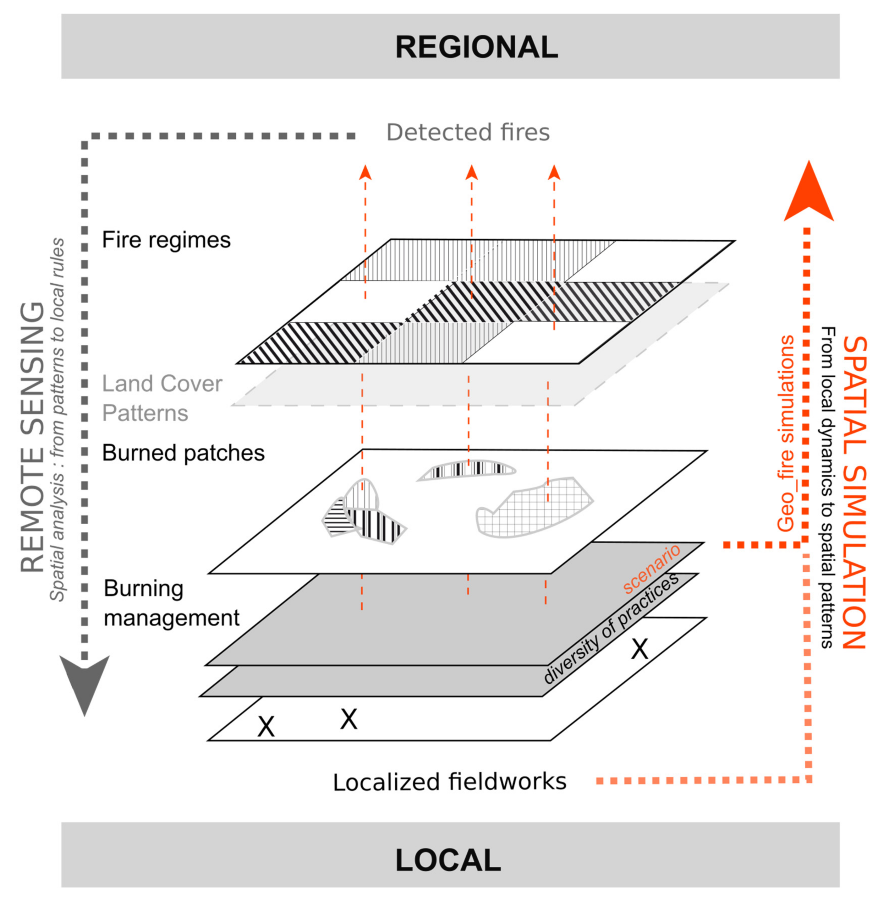
2. A Hybrid Approach: Fieldwork, Data, and Simulation

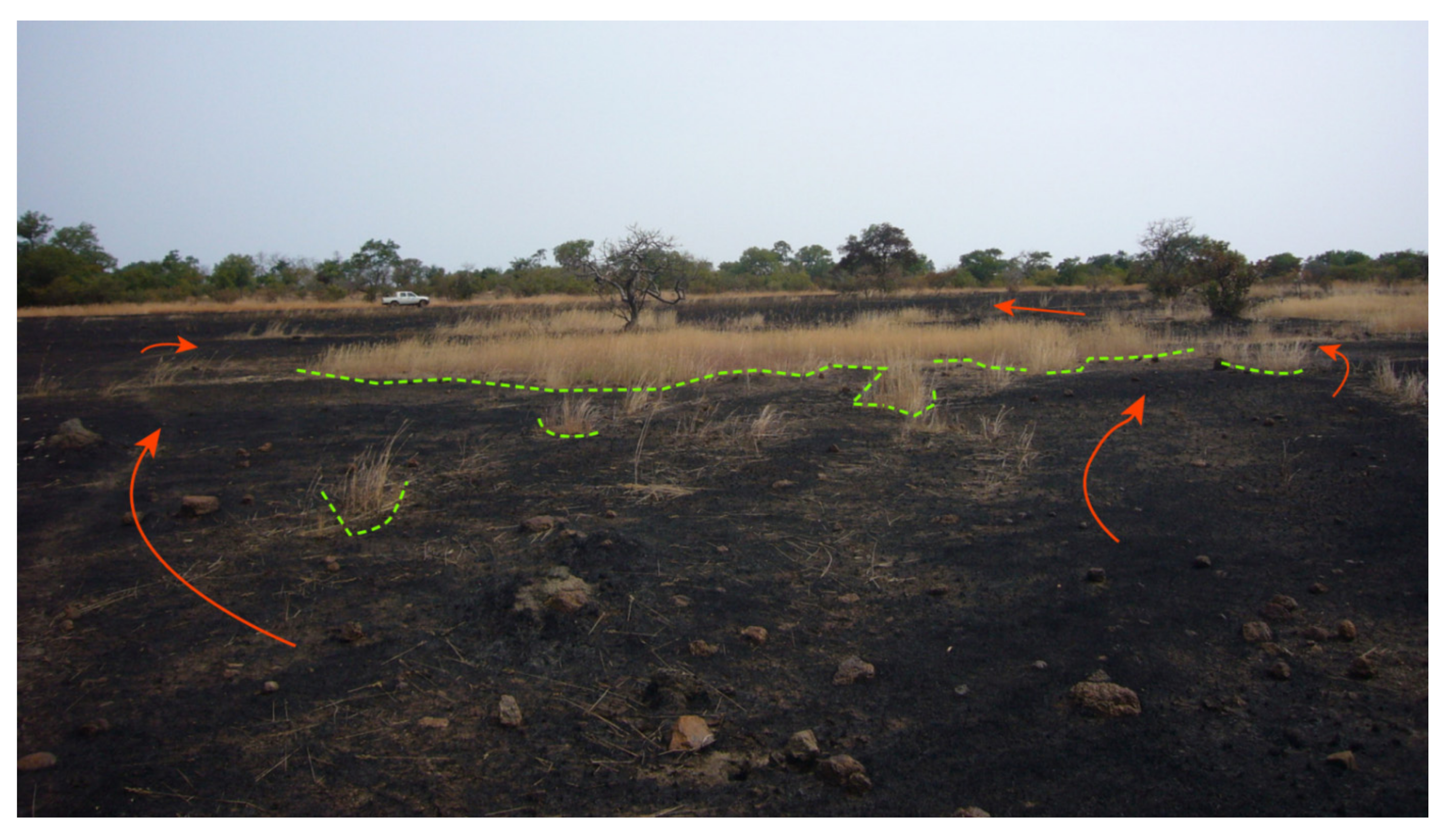
2.1. Fire Mosaics in West Africa

In the mesic savanna (700 mm to 1200 mm), fires are set in complex landscape mosaics combining patches with savanna vegetation (Combretum sp. and Andropogon sp.); patches with agricultural fields (millet, sorghum, and cotton), with permanent and semipermanent hydro-systems; and patches with bare soils with a thin layer of annual grasses [23,32,33]. The mesic savanna of West Africa is burned each year and produces complex burned mosaic landscapes associated with a stable fire regime [34,35]. In these rural regions, human activities are considerable and agropastoral activity dominates with an evolution that clearly shows areas under agriculture and the number of cattle increasing. Here, we define “humanized savannas” because in West African contexts there is no doubt that frequent burning by people has deeply influenced the biogeography of the region. Archaeological evidence dates the introduction of wide-scale firing of the African savanna at 400 000 years ago [9,36]. So “humanized savannas” is used to mean savannas that are composed of “working lands”, that is lands that are occupied and worked by people as opposed to areas managed as reserves [37]; the latter are most often used in fire research. The biomass and fuel conditions in working landscapes are a function of land use practices including rotational agriculture and animal grazing and can differ significantly from those found on nonworking lands, which can affect fire intensity [38]. There are also small protected areas that are somewhat controlled by environmental authorities and agropastoral areas that are often governed by a “chef de terre” (local authority in each village). The working-land approach differs significantly from the approach used in many savanna-fire studies globally which tend to focus on using reserves or protected areas as exclusive research sites, as is the case with the many studies from Southern Africa [39,40].

2.2. Exploring the Local Context and Fire Ignition Timing to Understand Regular Fire Regimes

Over the past twenty years, numerous studies working at the regional scale have examined the seasonal fire mosaic and its impact on vegetation [23,32]. These studies show a regular fire regime in space and time in savannas despite strong climate variability [34,35,41]. A number of hypotheses have been advanced to explain this regular pattern, and we are skeptical about causal and general explanations between human variables and fires behaviors. Specifically, we doubt there are linear relationships between aggregated variables such as density of population or roads and local fire management. While changes in population density in the West African countryside often result in changes in land cover, biomass loads, and fire occurrences, the ways in which fires are set do not necessarily change because the same social groups remain responsible for traditional fire practices such as hunting (Donzo) or herding societies.
As can be seen (Figure 1), burned areas are often small patches that burn grasses and shrubs. Trees rarely burn unless the fire is set too late in the dry season, when drier herbaceous vegetation can burn with greater intensity and taller flames, causing damage or “die-back” to smaller trees.
Based on numerous local-scale studies in West Africa [22,23,24,25,42], the most common fire-setting practices can be summed up in one phrase: “people burn grasses as soon as they are dry enough to burn”. This rule of thumb is supported by regional studies linking fire timing to fuel moisture indices [20]. Many purposeful fires are set against the wind and can be described as “creeping fires” that burn with low flame heights until they react a barrier such as a patch of grasses or woody vegetation with higher moisture content (Figure 1). In many West African landscapes, seasonal vegetation moisture levels are linked closely with soil type and soil moisture. Moreover, the soil organization generally follows topography and is quite heterogeneous. In upland areas known locally as bowé, the soils are often thin, supporting only a fine layer of annual grasses, which dry quickly following the end of rains, whereas in the valleys, the soils are deeper, supporting taller, often perennial, grasses, which remain green for a longer period. The soil structure is related to the water dependency of the grass strata; as such, the dry period begins in the uplands and ends in the lowlands. For these reasons, we argue that there is a general relationship between the topographical position and the date of burning at a local scale. To fully understand this local scheme, it is necessary to integrate these local processes into broader scale regional meteorological processes.
Finally, it is critical to study fire as a hybrid phenomenon combining both its biophysical and social components in West African savannas. On the one hand, we need to understand how people use fire, but due to the political context, which often prohibits burning [31], it is difficult to conduct formal interviews on burning practices. Farmers often give normative answers that do not reveal generalized practices. Fortunately, long-term experiences in the field combined with informal interviews provide a good insight into local fire practices [22,23,43]. On the other hand, remote sensing of burned areas has the potential to map local fire use. We caution however that, due to the complex and fine-scale land cover mosaic (agricultural plots < 1 ha) and the burned area mosaic, the commonly used remote sensing data and burned area algorithms still produce biases in space and time because the fine-scale burn scars from the early fire season are often ephemeral as ash blows away and trees resprout leaves following fire [44]. Another problem is how to analyze and explain local processes with regional data and maps because of the diverse and very complex spatial structures revealed at regional scales (patch size, diversity, timing, etc.). In standard spatial analysis using remote sensing, analysts often make assumptions to link spatial structures (mosaics) to potential processes (practices) without clearly testing them.

2.3. Bottom Up and Spatially Explicit Approach with Agent Based Modelling (ABM)

To study these interactions in West African savannas, we chose to use spatial simulation in addition to remote sensing data and local interviews, as shown in Figure 2.
Here, we introduce spatial simulation as a way to understand the production of fire regimes from local to regional scales and to draw some conclusions on the theoretical effects of fire intensity and severity on vegetation (specifically juvenile tree dieback) (Figure 2). This approach offers an experimental form to test fire regime production without being confined to experimental plots that operate on a small scale and produce “nonnatural” fire regimes such as those from prescribed fires. It also offers a flexible grain size and repeatability that enable us to think of fire as an everyday practice and not as data dependent on sensors with defined characteristics. We chose our modelling method for its ability to integrate spatial variables from local to regional with a dynamic approach [45]. Cellular automata and agent-based modelling are quite suitable for testing assumptions about environmental dynamics across scales [46,47,48,49,50,51]. Specifically, we have used the platform Netlogo and the GIS extension [52] to explore the annual regular fire regime created by peasants. At this research step, we mainly used our Geo_fire model as cellular automata to test fire dynamics from a simplified burning management scenario to regional fires regimes (in orange on Figure 2)

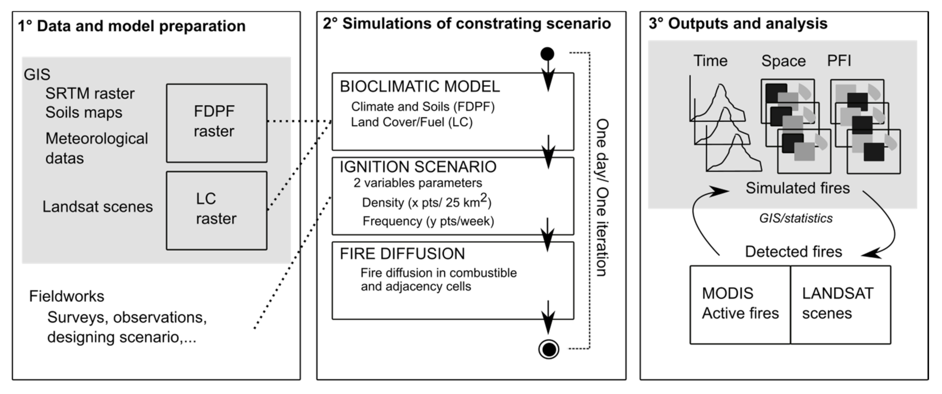
3. Detailed Methodology: Geographic Information System (GIS) and Geo_Fire Model Description

We can sum up our material and method in three steps following Reulier and colleagues [51]:

3.1. Data and Model Preparation (Fieldwork, GIS, and Climate Data)

First, we built spatial databases to be integrated in our model at the initialization. For soil properties, we built a raster with maximum water availability for each cell. This is based on fieldwork observations and identification with the help of soil map explanatory note [53], which gave us an estimation of soil depth and soil structure. This was combined with a Digital Elevation Model (United States Geological Survey Shuttle Radar Topography Mission) to add realistic spatial heterogeneity and positions of soils (valley, top soils, etc.). This raster represents a pattern of maximum water availability in soil at the end of the rainy season. It corresponds to soil moisture for herbaceous vegetation that burn in this region. We also have a climate raster where we combine spatialized meteorological data for each cell and each day based on different stations to combine average rainfall and average estimated evapotranspiration with census from 2001 to 2015 (National Oceanic and Atmospheric Administration, NOAA data https://www.ncdc.noaa.gov/data-access/land-based-station-data). We then used those two raster layers to estimate for each cell when soil is potentially without water. We refer to this raster layer as “raster with First Day of Potential Fire” (FDPF). At the end of this step of GIS data preparation, we add a Boolean land cover raster (LC) based on land cover remote sensing produced with Landsat scenes for burnable and nonburnable cells (e.g., agricultural fields, water, or urban areas).

3.2. Simulations of Contrasting Scenario

To describe our model Geo_fire, we used a simplified plan according to the Overview, Design concepts, and Details protocol (ODD) of Grimm and his colleagues [54].
Purpose: The model was designed to understand local parameters that affect fire regimes and patterns of burning landscapes. It is a simple model with spatially explicit data. We tested several scenarios based on fire frequency and density settings interacting in a controlled and realistic regional environment (climate, land cover, and soils). The hypothesis is that local parameters of ignition can produce significant changes in regional fire regimes despite regular and controlled biophysical systems. At the end of each simulation, the timing of fire is given, which can be compared to burn patterns from remote sensing data.
State Variables, Entities, and Scales: The model is spatial; it is built to correspond to an area studied in western Burkina Faso. The grid space represents a region of 1000 × 1000 cells with a cell size of 120 m (cell area = 1.44 ha). The time steps in the model are daily during a single fire season (30 September to 30 March). The model works mainly as a cellular automata model. Each cell has several properties linked with fire properties:
  • Land cover (LC): this variable allows the fire to propagate or not; it is based on a map built with Landsat scene.
  • Raster with first day of potential fire (FDPF): this variable gives the date of the first potential fire by cell, an estimation based on meteorological census data.
Process Overview and Scheduling: The spatial simulation starts at the end of the rainy season (30 September; day 1 in the simulation) and runs through the end of the burning season (30 March). In the dry season, water availability in the soil decreases each day depending on the local (soils) and regional properties (climate). Each day can be a burnable day depending on the ignition frequency (x times/week) and the ignition density entered (y points/surface). A cell can burn only one time during this virtual dry season (Figure 3). As such, for each day, a cell can burn if there is fuel (with vegetation in a LC raster), if there is no water in the cell (FDPF raster) and if it has not burned before.
To test the degree of human control on the fire regimes observed, we simulated two gradients to test how fire practices could affect fire regime patterns at a regional scale. We choose here to present only 9 scenarios (Table 1) in order to focus on our bottom-up approach (and not exclusively on the model itself).
Gradient of fire ignition density. We simulated a variable probability of fire ignition points among cells that can burn each day. Here, we present a gradient going from 2 to 6 points for a burnable surface of 25 sq.km. This shows how the density of daily fire practices (number of fires started) can alter regional patterns during one dry season.
Gradient of fire ignition frequency. The regularity of fire practices is tested with a variable that assigns a variation in fire ignition frequency over 7 days (one week). More precisely, we assign a frequency of x days out of 7 to be defined as a burnable or not. Therefore, a frequency of 7/7 is a regular daily practice, whereas a frequency of 3/7 is a nonregular frequency.

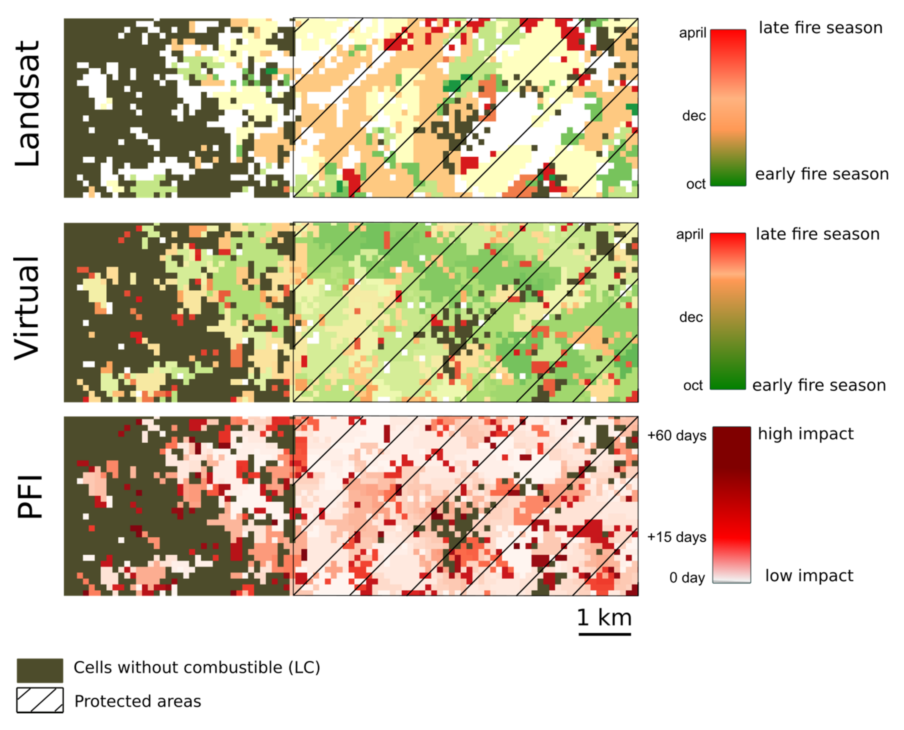
3.3. Outputs and Analysis

At the end of each simulation, we have several outputs that allow us to understand fires regimes and their behaviors in space and time. The simulation produces the amount of burned area each day to evaluate the dynamics and the total burned areas at the end of a fire season. In addition, we have created and evaluated a new index called potential fire impact (PFI) (Figure 4). PFI is an index corresponding to the difference between the day when the cell actually burned and the day when fire can spread theoretically (FDPF). The global PFI index corresponds to the percentage of cells that have burned 15 days after the first day of potential fire. The higher this index, the more intense the fire regimes because fire intensity is, in part, a function of fuel moisture level. More intense fires have higher flame heights and have a correspondingly greater impact on vegetation including more juvenile tree deaths [35,55]. The PFI is a key variable and an important advancement over the common practice of simply predicting the impacts of fire according to a rather crude index of early/late fires, which is often used in the savanna literature and is not particularly useful in the context of complex fire regimes [56]. Finally, we compared the simulated fire dynamics with references we have from remote sensing data. According to data capabilities, for fire regime timing, we used daily MODIS Active Fires data (Moderate-Resolution Imaging Spectroradiometer). We calculated an average over sixteen fire seasons to find the date when 50% of the total burned area had burned for a season. To determine spatial pattern, we used burned scars generated from Landsat scenes to compare Mean Patch Size (MPS) of real mosaic with our simulations.

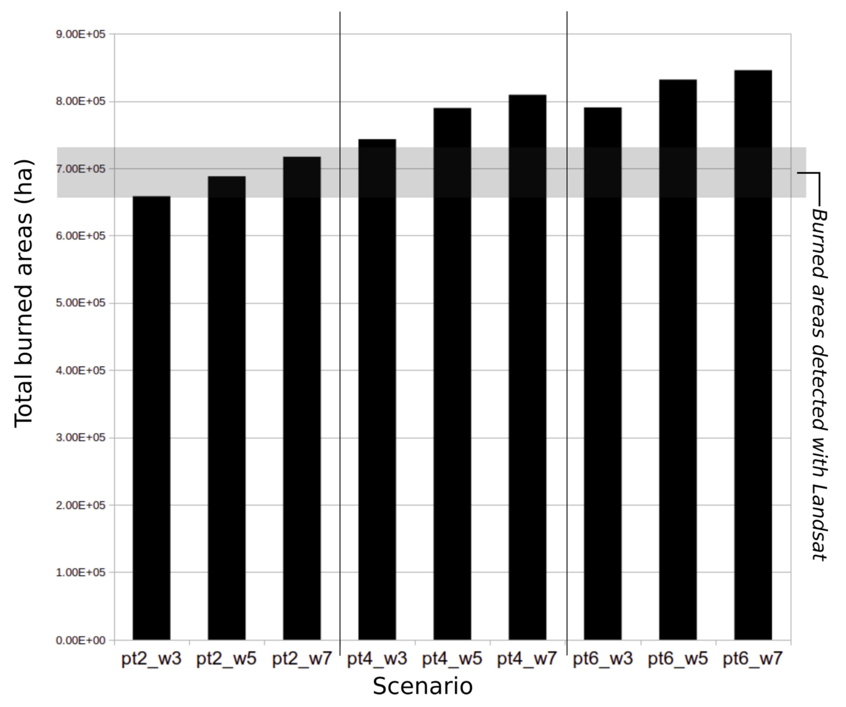
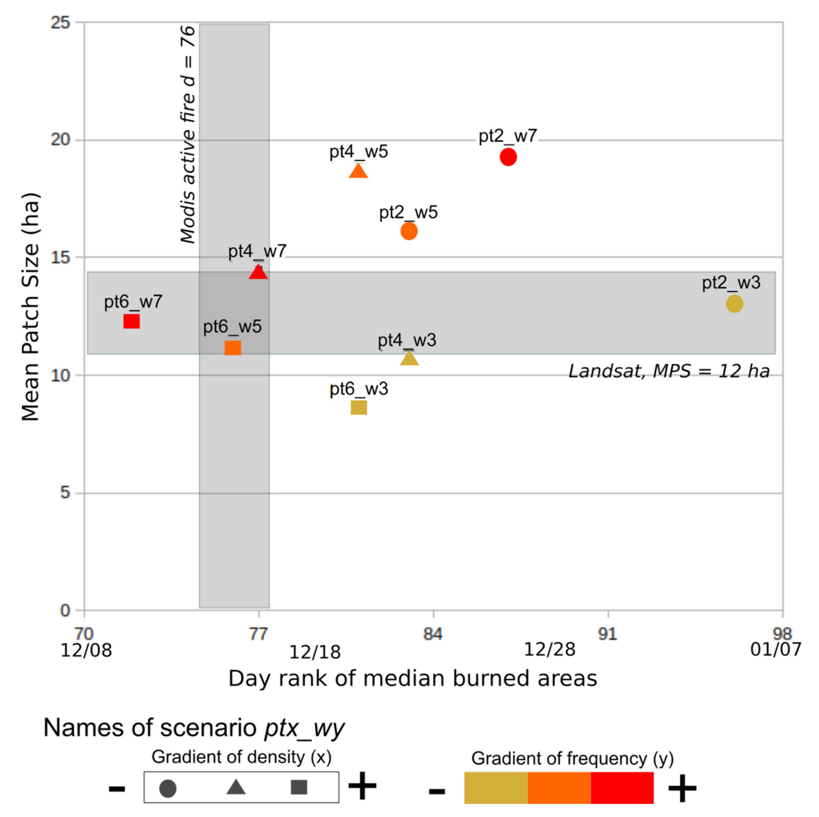
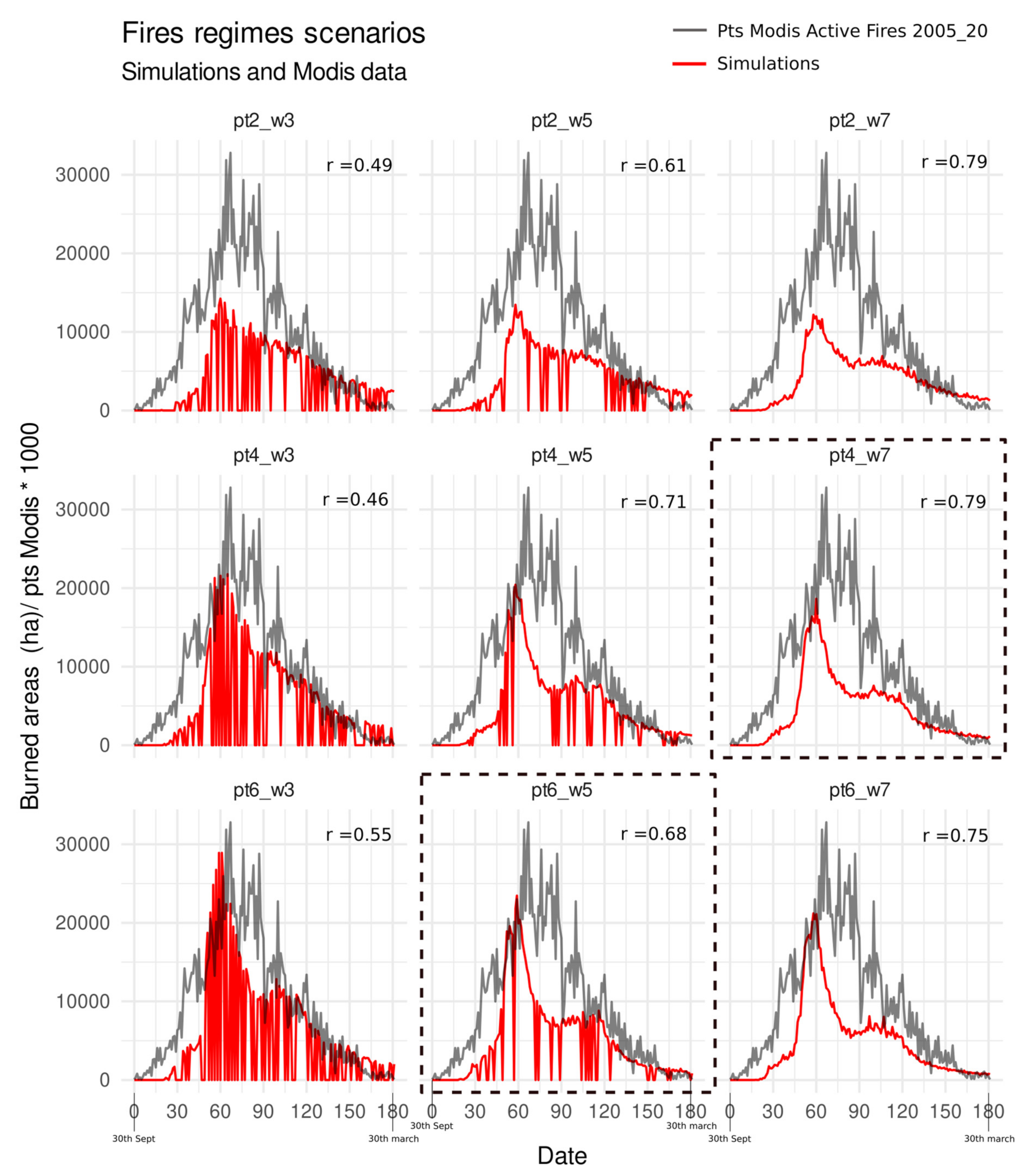
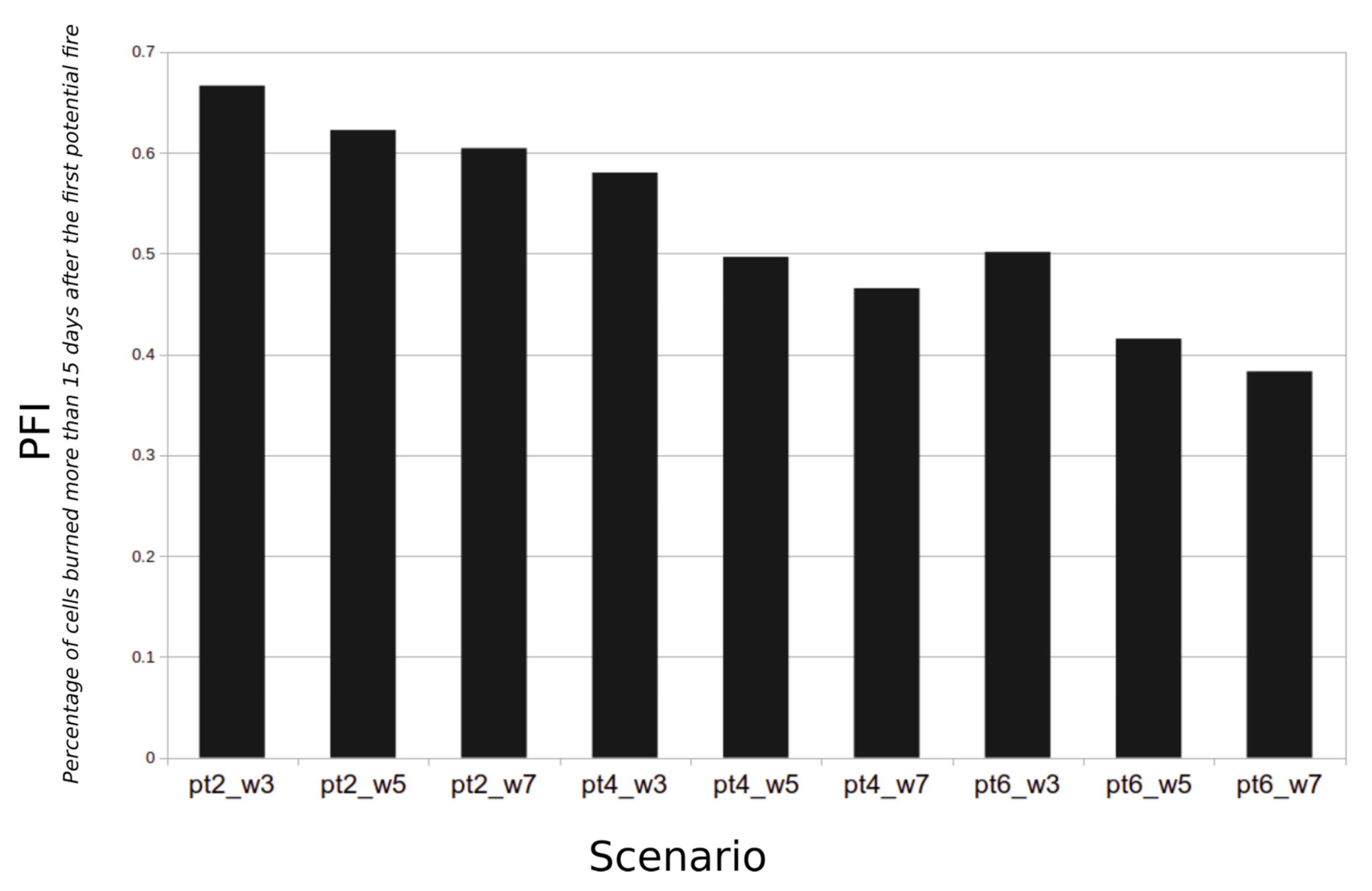
4. Behaviors and Results of Geo_Fire Model

Figure 5 shows the variation in total burned area for nine different burn scenarios, each one based on the same model Geo_Fire. We can see that all scenarios are able to simulate a burned surface that resembles the burned surface detected by the Landsat satellite (approx. 700,000 ha/per year for this study area). The analysis shows a logical dynamic where higher frequency and higher density of ignitions produce more burned areas.
Figure 6 is a graphic representation of our simulated scenarios. On the X axis, we show the fire regime timing with the MODIS active fire reference. On the Y axis, we show the spatial structure of the fire mosaic with the Landsat reference. This figure indicates the usefulness of our Geo_fire model because it is possible to explore how fire regimes created by peasants can shift in space and time. At the intersection of the two references (MODIS for timing and Landsat for spatial), we are able to determine two scenarios (pt4_w7 and pt6_w5) that are most similar to the current reality of West African fire regimes.
The outcomes of all scenarios are represented in Figure 7. A Pearson correlation score was done between simulation and MODIS actives fires dynamics observed. Scenarios with higher scores are scenarios with a high frequency of fire settings (Pt x_w7). For the two key scenarios (r(pt4_w7) = 0.79 and r(pt6_w5) = 0.68) that are able to replicate temporal and spatial fires regimes, we can observe a high and positive score. These scores and the curve delay indicate that our model is not perfect, but it creates a reasonable reproduction of the structural and functional dynamics of West African fire regimes. The delay between virtual and “average fire” seasons (2005–2020) can be easily explained by a model which works in a perfect dry season without irregularities (e.g., rainy day in October, cloudy weather during one week in December, etc.).
Finally, in Figure 8, we show scenario results according to the percentage of cells that burn a long time (15 days) after their potential first day of fire (PFI). Here, it is clear that minor changes in local dynamics can dramatically alter the nature of the fire regime. The higher the percentage of PFI (proportion of cells burned 15 days and more after the potential day of fire), the more fires occurred under very low fuel moisture conditions with potentially severe impacts on vegetation. The figure allows us to understand how this Geo_Fire model can evaluate specific fires regime changes, allowing us to evaluate each fire in a local context, a key parameter which is able to make an estimation on potential damages on vegetation and on gas emissions.
At the end of the analysis of these nine scenarios, we observe highly diverse fire regimes in spite of a simulated deterministic biophysical system based solely on soils and weather. These outcomes demonstrate the importance of the commonly forgotten—or more commonly simulated as a random factor—of local fire settings and its influence on regional fire regimes. In this study, an “intermediate” fire ignition density is required to successfully reproduce the fire regimes observed; however, this is only possible if the fire ignition frequency is also very regular. This virtual model, with no preestablished dynamics for producing structured fire regimes (simple spread of fire, no wind effect, etc.), simulates spatial and temporal fire structures analogous to those observed by satellites in West Africa. As such, it demonstrates the critical relationship between the dynamics of the soil moisture/grass stratum and the regular and generalized fire practices in these regions.

5. Discussion: A Model to Explore Fire Regimes in their Socio-Ecological Contexts

5.1. Modelling Humanized Savannas: Lessons from West African Landscapes

Our model demonstrates how local dynamics based on practices observed on the ground provides a close approximation of the regional spatiotemporal patterns of the fire regimes. It confirms the critical role biophysical variables including water availability in soils (soils structure + topography + climate) to shape fire behavior in savannas. Moreover, by simulating only soil water availability and a single type of vegetation (grasses), the model works well when compared to the fire dynamics observed in West Africa.
The model enables us to draw a contextualized portrait of the savanna systems where fires are set and controlled by rural inhabitants with specific knowledges and practices. In contrast, unlike much literature on savanna systems, we were able to simulate burn patterns that resemble those observed without integrating variables that are typically important in other environments. Indeed, without abiotic variables such as wind or complex biophysical fire behavior models, it appears that we can simulate West African regimes. This does not minimize the importance of other variables, but it helps to mitigate their roles probably due to how people regularly control fires by setting them day after day with the help of conditions that promote the spread of fire (wind at midday for example) or that stop it (humidity at the end of the day). Likewise, we can question the role of biotic variables because, without diverse vegetation, that is, with just binary land cover, we can simulate observed fire regimes. This is critical because it means that the tree layer in these contexts probably plays only a small role in determining fire regimes. It explains why tree cover is probably not a key variable for understanding fire’s impacts in mesic West African landscapes (the exception would be densely wooded areas normally found riparian corridors). The differentiated water balance dynamics of trees and grasses are observed and interpreted by peasants, and they set fire at a time when only the grass is dry enough to burn. Under the canopies, very often, the soil moisture does not allow fire to reach the larger trees despite a dense and regular fire regime.

5.2. Modelling: Limits and Questions

After a decade of progress resulting from the development of more sophisticated remote sensing algorithms to detect and map fire regimes more accurately, questions about the stability of fire regimes in unstable environments have been raised for mesic savannas [57,58,59]. Although spatiotemporal analysis of burn patterns provides some answers concerning fire regime repeatability or regularity, here, we have given a more functional explanation through modelling. This perspective does have some limits, however, such as its calibration with data from satellites. To improve the calibration of our model, one option is to adjust our virtual outputs to more closely resemble results from the remote sensing data. The problem, however, is that the daily satellite data are crude while the more accurate land cover data do not provide information about fire timing. For example, we think that Landsat detection provides a good estimation of the spatiotemporal pattern of burning; however, burned areas are sometimes missed due to gaps in the image datasets and the rapid speed at which perennial grasses resprout following a fire. For daily satellite data (MODIS; VIIRS (Visible Infrared Imaging Radiometer Suite)), the complex landscape mosaic with fine agricultural and fallow plots produces a fragmented mosaic of burn scars which are difficult to map accurately or with confidence. Within limits given to properly compare simulation and remote sensing results, we believe that this experimental model can evolve to include a more accurate spatial grid, associated with more realistic fire behaviors.
Our study thus presents a “first step” with a general approach that provides new insights that can be a foundation for adding more detailed inputs such as grass types (perennial or annual), cattle grazing patterns (reduction of flammable biomass), or more detailed fire practices (techniques, fire lines ignitions, and fire with the wind vs. facing to the wind). In addition, the model could be linked with data on greenhouse gas emissions from fires to provide detailed models of emissions, which are a function of vegetation moisture content and thus fire timing.

5.3. Perspectives on Fire Regimes

Our model is proposed as a first step; it has been built to evolve and can easily be adapted to other regions and to address new questions. Its strength is that it opens new ways of exploring the human dimension of fire regime changes. For example, in West African savannas, changes in cattle pressure and grass composition are probably important components of fire modelling and incorporating data on these factors could improve our modelling as well as our knowledge. In non-fenced protected areas, where cattle grazing is an important activity, fire dynamics appear to be different—there are typically larger and more intense fires. A key challenge remains to understand the relationship between patterns and processes. What causes observed differences in fire regimes: different fire practices or the vegetation patterns themselves [60]? In our simulations, spatial patterns of seasonal mosaic burning differ inside and outside protected areas, a view that corresponds to that documented by satellite image analysis and in the field. The functional approaches of simulation allow us to demonstrate that, with the same ignition process (density and frequency), a different fire regime can be produced inside and outside protected areas. It clearly shows that protected land cover has an impact on fire regimes in this case which demonstrate how environmental policies can produce new environmental dynamics and thus illustrate a facet of Anthropocene Era in West Africa. Fires are becoming more severe in these protected areas (Protected areas are often unfarmed but grazed and burned by local populations) while there are also differences in biodiversity inside and outside them [61].
Likewise, the relative stability of fire regimes in West Africa—despite variability across climatic seasons—appears at first puzzling. Use of different climate scenarios could help explore the relationships between local climate conditions and fire setting to understand better not only the regularity of fire practices but also the impacts on vegetation and gas emissions. Questions such as vegetation impact and carbon stock in soils are clearly dependent on the local fire conditions. Currently environmental policies attempt to integrate those parameters into their global agenda (deforestation, soil fertility, gas mitigation, etc.), but without robust knowledge in specific contexts, these efforts maybe destined to fail. We can add that our knowledge about fires regimes is very dependent on data from modern satellites and thus cannot help us to study fires regimes changes before the 1990s. The modelling approach across scales can evolve easily to integrate other key variables without being dependent on satellite constraints or biases or global categories [56] that are not useful to study these processes in a specific context.

6. Conclusions

This study uses explicit spatial modelling scenarios to create a human and contextualized dimension to fire regimes without losing the biophysical perspective. We simulate the human dimension as local dynamics based on empirical assumptions built by fieldwork experience and regional studies. By focusing on fire regimes produced by local inhabitants, we create a model to study fires as evolving practices dependent on biophysical parameters. We chose this approach to evaluate how people can control fire regimes and how they can regionally shape regular fire regimes. Our results show that the human dimension in West African savannas is clearly an important variable and is probably more important than in other regions of the world due to past and present generalized practices [9,62,63]. By modelling a process where fires are set as an everyday practice linked to soil moisture and grass layer, it appears that we were able to reproduce fire regimes similar to those detected and mapped by satellites currently.
This model is original in that the human dimension is not a supplementary variable but clearly the core of the model [11], simplified here as density and frequency of fire ignitions. This allowed us to test several scenarios without excluding other important parameters such as land cover, bio-climatic aspects, etc. This bottom-up approach is not new in savanna systems [19,58], but here, it presents an intermediate level that can integrate evolving heterogeneous landscapes produced by people from local to regional scales. We used ABM as one way to study this topic where fieldwork and/or remote sensing have provided the dominant perspectives. Going from regional data to local process explanations is not always easy, and there is a great deal of approximation. This is why we used the ABM method as a complementary way of studying savanna systems, and we find it very useful to think of fire in the local context of burning in time and space. In addition, we think that this perspective can help researchers have a more functional approach by reducing the distance between lab work (GIS, statistics, etc.) and fieldwork with people setting fires in the savanna.
In this study, we have focused on thematic issues probably more than on the model itself. By focusing attention on the human dimension, we try to offer a direction for studying environmental change in rural areas where fire management still remains a problem in terms of modern issues such as gas emissions, economic conflicts associated with cotton expansion, high density of cattle, changes in grass species, etc. By creating a model that clearly includes fire as a managed process in savanna landscape mosaics, we hope that this approach can stimulate new perspectives on savanna management by reducing the gap between fire impact studies and more contextualized research working on the reasons of fire practices.

Author Contributions

Conceptualization, S.C., A.B., and D.D.; methodology, S.C.; model and data, S.C. and C.F.; validation, S.C. and C.F.; writing—original draft preparation, S.C.; writing—review and editing, S.C., P.L., and A.B. All authors have read and agreed to the published version of the manuscript.

Funding

This research received no external funding.

Acknowledgments

This research was carried out with the help of public institutions (fieldwork and equipment) with permanent statutes that allow for long-term research. Translation and publication were support by CNRS (UMR ESO and PEPS-BBQ project).

Conflicts of Interest

The authors declare no conflict of interest.

References

  1. Bowman, D.M.; Balch, J.; Artaxo, P.; Bond, W.J.; Cochrane, M.A.; D’antonio, C.M.; DeFries, R.; Johnston, F.H.; Keeley, J.E.; Krawchuk, M.A. The human dimension of fire regimes on Earth. J. Biogeogr. 2011, 38, 2223–2236. [Google Scholar] [CrossRef] [PubMed] [Green Version]
  2. Andela, N.; Morton, D.C.; Giglio, L.; Chen, Y.; Van Der Werf, G.R.; Kasibhatla, P.S.; DeFries, R.S.; Collatz, G.J.; Hantson, S.; Kloster, S. A human-driven decline in global burned area. Science 2017, 356, 1356–1362. [Google Scholar] [CrossRef] [PubMed] [Green Version]
  3. Bond, W.J.; Woodward, F.I.; Midgley, G.F. The global distribution of ecosystems in a world without fire. New Phytol. 2005, 165, 525–538. [Google Scholar] [CrossRef] [PubMed]
  4. Bowman, D.M.J.S.; Balch, J.K.; Artaxo, P.; Bond, W.J.; Carlson, J.M.; Cochrane, M.A.; D’Antonio, C.M.; DeFries, R.S.; Doyle, J.C.; Harrison, S.P. Fire in the Earth system. Science 2009, 324, 481. [Google Scholar] [CrossRef] [PubMed]
  5. Van Der Werf, G.R.; Randerson, J.T.; Giglio, L.; Van Leeuwen, T.T.; Chen, Y.; Rogers, B.M.; Mu, M.; Van Marle, M.J.; Morton, D.C.; Collatz, G.J. Global fire emissions estimates during 1997–2016. Earth Syst. Sci. Data 2017, 9, 697–720. [Google Scholar] [CrossRef] [Green Version]
  6. Scholes, R.J.; Archer, S.R. Tree-grass interactions in savannas. Ann. Rev. Ecol. Syst. 1997, 28, 517–544. [Google Scholar] [CrossRef]
  7. Parr, C.L.; Andersen, A.N. Patch mosaic burning for biodiversity conservation: A critique of the pyrodiversity paradigm. Conserv. Biol. 2006, 20, 1610–1619. [Google Scholar] [CrossRef]
  8. Laris, P. Integrating land change science and savanna fire models in West Africa. Land 2013, 2, 609–636. [Google Scholar] [CrossRef]
  9. Ballouche, A. Fire-prone landscapes in the West African savanna. Present-day dynamics and historical roots. In Of Trees, Grasses and Crops–Man and Vegetation Change in Sub-Saharan Africa and Beyond; Hoen, A., Eichhorn, B., Eds.; Verlag Dr. Rudolf Habelt: Bonn, Germany, 2019; Volume 37, pp. 17–29. [Google Scholar]
  10. Bliege Bird, R.; Bird, D.W.; Codding, B.F.; Parker, C.H.; Jones, J.H. The “fire stick farming” hypothesis: Australian aboriginal foraging strategies, biodiversity, and anthropogenic fire mosaics. Proc. Natl. Acad. Sci. USA 2008, 105, 14796. [Google Scholar] [CrossRef] [Green Version]
  11. Coughlan, M.R. Traditional fire-use, landscape transition, and the legacies of social theory past. Ambio 2015, 44, 705–717. [Google Scholar] [CrossRef] [Green Version]
  12. Eloy, L.; Schmidt, I.B.; Borges, S.L.; Ferreira, M.C.; Dos Santos, T.A. Seasonal fire management by traditional cattle ranchers prevents the spread of wildfire in the Brazilian Cerrado. Ambio 2019, 48, 890–899. [Google Scholar] [CrossRef] [PubMed]
  13. Coughlan, M.R.; Petty, A.M. Linking humans and fire: A proposal for a transdisciplinary fire ecology. Int. J. Wildland Fire 2012, 21, 477–487. [Google Scholar] [CrossRef]
  14. Archibald, S.; Lehmann, C.E.R.; Gómez-Dans, J.L.; Bradstock, R.A. Defining pyromes and global syndromes of fire regimes. Proc. Natl. Acad. Sci. USA 2013, 110, 6442–6447. [Google Scholar] [CrossRef] [Green Version]
  15. Tedim, F.; Leone, V.; Amraoui, M.; Bouillon, C.; Coughlan, M.R.; Delogu, G.M.; Fernandes, P.M.; Ferreira, C.; McCaffrey, S.; McGee, T.K.; et al. Defining extreme wildfire events: Difficulties, challenges, and impacts. Fire 2018, 1, 9. [Google Scholar] [CrossRef] [Green Version]
  16. Dennis, R.A.; Mayer, J.; Applegate, G.; Chokkalingam, U.; Colfer, C.J.P.; Kurniawan, I.; Lachowski, H.; Maus, P.; Permana, R.P.; Ruchiat, Y. Fire, people and pixels: Linking social science and remote sensing to understand underlying causes and impacts of fires in Indonesia. Hum. Ecol. 2005, 33, 465–504. [Google Scholar] [CrossRef]
  17. Eloy, L.; Hecht, S.; Steward, A.; Mistry, J. Firing up: Policy, politics and polemics under new and old burning regimes. Geogr. J. 2019, 185, 2–9. [Google Scholar] [CrossRef]
  18. Mistry, J.; Schmidt, I.B.; Eloy, L.; Bilbao, B. New perspectives in fire management in South American savannas: The importance of intercultural governance. Ambio 2019, 48, 172–179. [Google Scholar] [CrossRef] [Green Version]
  19. Archibald, S.; Staver, A.C.; Levin, S.A. Evolution of human-driven fire regimes in Africa. Proc. Natl. Acad. Sci. USA 2012, 109, 847–852. [Google Scholar] [CrossRef] [PubMed] [Green Version]
  20. Le Page, Y.; Oom, D.; Silva, J.; Jönsson, P.; Pereira, J. Seasonality of vegetation fires as modified by human action: Observing the deviation from eco climatic fire regimes. Glob. Ecol. Biogeogr. 2010, 19, 575–588. [Google Scholar] [CrossRef]
  21. Trauernicht, C.; Brook, B.W.; Murphy, B.P.; Williamson, G.J.; Bowman, D.M. Local and global pyrogeographic evidence that indigenous fire management creates pyrodiversity. Ecol. Evol. 2015, 5, 1908–1918. [Google Scholar] [CrossRef] [Green Version]
  22. Bruzon, V. Les pratiques du feu en Afrique subsaharienne: Exemples des milieux savanicoles de la Centrafique et de la Côte d’Ivoire. In Dynamique des Systèmes Agraires: À la Croisée des Parcours: Pasteurs, Éleveurs, Cultivateurs; ORSTOM: Paris, France, 1994; pp. 148–162. ISBN 2-7099-1228-7. [Google Scholar]
  23. Laris, P. Burning the seasonal mosaic: Preventative burning strategies in the wooded savanna of southern Mali. Hum. Ecol. 2002, 30, 155–186. [Google Scholar] [CrossRef]
  24. Caillault, S. Le Feu, la Brousse et la Savane. Modélisation Spatiale de la Dynamique des Paysages Soudaniens (Burkina Faso). Ph.D. Thesis, Université de Caen Basse Normandie, 2011. Available online: https://halshs.archives-ouvertes.fr/tel-00625721/ (accessed on 2 November 2020).
  25. Fournier, A.; Douanio, M.; Bene, A. Pratique et perception des feux de végétation dans un paysage de vergers. Le pays sèmè (Kénédougou, Burkina Faso). In Regards Scientifiques Croisés sur le Changement Global et le Développement - Langue, Environnement, Culture: Actes du Colloque International de Ouagadougou (8–10 Mars 2012); Sciencesconf.org: Ouagadougou, Burkina Faso, 2012; pp. 201–229. Available online: https://hal.archives-ouvertes.fr/hal-00939895/ (accessed on 2 November 2020).
  26. Moreira, F.; Ascoli, D.; Safford, H.; Adams, M.A.; Moreno, J.M.; Pereira, J.M.C.; Catry, F.X.; Armesto, J.; Bond, W.; González, M.E.; et al. Wildfire management in Mediterranean-type regions: Paradigm change needed. Environ. Res. Lett. 2020, 15, 011001. [Google Scholar] [CrossRef]
  27. Russell-Smith, J.; Lucas, D.; Gapindi, M.; Gunbunuka, B.; Kapirigi, N.; Namingum, G.; Lucas, K.; Giuliani, P.; Chaloupka, G. Aboriginal resource utilization and fire management practice in western Arnhem Land, monsoonal northern Australia: Notes for prehistory, lessons for the future. Hum. Ecol. 1997, 25, 159–195. [Google Scholar] [CrossRef]
  28. Eriksen, C. Why do they burn the’bush’? Fire, rural livelihoods, and conservation in Zambia. Geogr. J. 2007, 173, 242–256. [Google Scholar] [CrossRef]
  29. Bassett, T.J.; Bi, Z.K.; Ouattara, T. Fire in the Savanna. Environmental change and land reform in Northern Cote d’Ivoire. In African Savannas. Global Narratives and Local Knowledge; James Currey: Oxford, UK, 2003; pp. 53–71. [Google Scholar]
  30. Kull, C.A.; Laris, P. Fire ecology and fire politics in Mali and Madagascar. Trop. Fire Ecol. 2009, 171–226. [Google Scholar]
  31. Laris, P.; Wardell, D.A. Good, bad or’necessary evil’? Reinterpreting the colonial burning experiments in the savanna landscapes of West Africa. Geogr. J. 2006, 172, 271–290. [Google Scholar] [CrossRef]
  32. Devineau, J.L.; Fournier, A.; Nignan, S. Savanna fire regimes assessment with MODIS fire data: Their relationship to land cover and plant species distribution in western Burkina Faso (West Africa). J. Arid Environ. 2010, 74, 1092–1101. [Google Scholar] [CrossRef] [Green Version]
  33. Diouf, A.; Barbier, N.; Lykke, A.M.; Couteron, P.; Deblauwe, V.; Mahamane, A.; Saadou, M.; Bogaert, J. Relationships between fire history, edaphic factors and woody vegetation structure and composition in a semi-arid savanna landscape (Niger, West Africa). Appl. Veg. Sci. 2012, 15, 488–500. [Google Scholar] [CrossRef]
  34. Laris, P.; Caillault, S.; Dadashi, S.; Jo, A. The human ecology and geography of burning in an unstable savanna environment. J. Ethnobiol. 2015, 35, 111–140. [Google Scholar] [CrossRef] [Green Version]
  35. Caillault, S.; Ballouche, A.; Delahaye, D. Where are the ‘bad fires’ in W est A frican savannas? Rethinking burning management through a space–time analysis in Burkina Faso. Geogr. J. 2015, 181, 375–387. [Google Scholar] [CrossRef] [Green Version]
  36. Bird, M.I.; Cali, J.A. A million-year record of fire in sub-Saharan Africa. Nature 1998, 394, 767–769. [Google Scholar] [CrossRef]
  37. Charnley, S.; Sheridan, T.E.; Nabhan, G.P. Stitching the West Back Together: Conservation of Working Landscapes; University of Chicago Press: Chicago, IL USA, 2014; 352p, ISBN 0-226-16585-X. [Google Scholar]
  38. Laris, P.; Jacobs, R.; Kone, M.; Dembele, F.; Rodrigue, C.M.; Camara, F. Determinants of Fire Intensity and Severity in a Mesic Savanna of Africa. Fire Ecol. 2020. published soon. [Google Scholar]
  39. Wilgen, B.W.V.; Govender, N.; Biggs, H.C.; Ntsala, D.; Funda, X.N. Response of savanna fire regimes to changing fire-management policies in a large African National Park. Conserv. Biol. 2004, 18, 1533–1540. [Google Scholar] [CrossRef]
  40. Balfour, D.A.; Howison, O.E. Spatial and temporal variation in a mesic savanna fire regime: Responses to variation in annual rainfall. Afr. J. Range Forage Sci. 2002, 19, 45–53. [Google Scholar] [CrossRef]
  41. Pereira, J.M.C.; Oom, D.; Pereira, P.; Turkman, A.A.; Turkman, K.F. Religious affiliation modulates weekly cycles of cropland burning in Sub-Saharan Africa. PLoS ONE 2015, 10, e0139189. [Google Scholar] [CrossRef]
  42. Walters, G. Customary fire regimes and vegetation structure in Gabon’s Bateke Plateaux. Hum. Ecol. 2012, 40, 943–955. [Google Scholar] [CrossRef]
  43. Dugast, S. Des sites sacrés aincendier. Feux rituels et bosquets sacrés chez les Bwaba du Burkina Faso et les Bassar du Togo. Anthropos 2006, 101, 413–428. [Google Scholar] [CrossRef]
  44. Laris, P.S. Spatiotemporal problems with detecting and mapping mosaic fire regimes with coarse-resolution satellite data in savanna environments. Remote Sens. Environ. 2005, 99, 412–424. [Google Scholar] [CrossRef]
  45. Kehrwald, N.M.; Aleman, J.; Coughlan, M.; Courtney-Mustaphi, C.; Githumbi, E.; Magi, B.; Marlon, J.; Power, M.J. One thousand years of fires: Integrating proxy and model data. Front. Biogeogr. 2016, 8, 1–5. [Google Scholar] [CrossRef]
  46. Bousquet, F.; Le Page, C. Multi-agent simulations and ecosystem management: A review. Ecol. Model. 2004, 176, 313–332. [Google Scholar] [CrossRef]
  47. Guermond, Y.; Delahaye, D.; Dubos-Paillard, E.; Langlois, P. From modelling to experiment. GeoJournal 2004, 59, 171–176. [Google Scholar] [CrossRef]
  48. Matthews, R.B.; Gilbert, N.G.; Roach, A.; Polhill, J.G.; Gotts, N.M. Agent-based land-use models: A review of applications. Landsc. Ecol. 2007, 22, 1447–1459. [Google Scholar] [CrossRef] [Green Version]
  49. Hamill, L. Agent-Based modelling: The next 15 years. J. Artif. Soc. Soc. Simul. 2010, 13, 7. [Google Scholar] [CrossRef]
  50. Perry, G.L.; Wilmshurst, J.M.; McGlone, M.S.; McWethy, D.B.; Whitlock, C. Explaining fire-driven landscape transformation during the Initial Burning Period of New Zealand’s prehistory. Glob. Chang. Biol. 2012, 18, 1609–1621. [Google Scholar] [CrossRef]
  51. Reulier, R.; Delahaye, D.; Viel, V. Agricultural landscape evolution and structural connectivity to the river for matter flux, a multi-agents simulation approach. Catena 2019, 174, 524–535. [Google Scholar] [CrossRef]
  52. Tisue, S.; Wilensky, U. NetLogo: A Simple environment for modeling complexity. In Proceedings of the International Conference on Complex Systems, Boston, MA, USA, 16–21 May 2004; pp. 16–21. [Google Scholar]
  53. Leprun, J.C. Étude pédologique de la Haute-Volta: Région ouest-nord: Notice et carte au 1/500 000 [Maps]; ORSTOM: Paris, France, 1968. [Google Scholar]
  54. Grimm, V.; Berger, U.; Bastiansen, F.; Eliassen, S.; Ginot, V.; Giske, J.; Goss-Custard, J.; Grand, T.; Heinz, S.K.; Huse, G. A standard protocol for describing individual-based and agent-based models. Ecol. Model. 2006, 198, 115–126. [Google Scholar] [CrossRef]
  55. Sankaran, M.; Hanan, N.P.; Scholes, R.J.; Ratnam, J.; Augustine, D.J.; Cade, B.S.; Gignoux, J.; Higgins, S.I.; Le Roux, X.; Ludwig, F. Determinants of woody cover in African savannas. Nature 2005, 438, 846–849. [Google Scholar] [CrossRef] [PubMed]
  56. Laris, P.; Koné, M.; Dadashi, S.; Dembele, F. The early/late fire dichotomy: Time for a reassessment of Aubréville’s savanna fire experiments. Prog. Phys. Geogr. 2017, 41, 68–94. [Google Scholar] [CrossRef]
  57. Jeltsch, F.; Milton, S.J.; Dean, W.R.J.; Rooyen, N.; Moloney, K.A. Modelling the impact of small scale heterogeneities on tree—Grass coexistence in semi arid savannas. J. Ecol. 1998, 86, 780–793. [Google Scholar] [CrossRef] [Green Version]
  58. Higgins, S.I.; Bond, W.J.; Trollope, W.S.W. Fire, resprouting and variability: A recipe for grass–tree coexistence in savanna. J. Ecol. 2000, 88, 213–229. [Google Scholar] [CrossRef]
  59. Laris, P.; Jo, A.; Wechsler, S.P. Effects of landscape pattern and vegetation type on the fire regime of a mesic savanna in Mali. J. Environ. Manag. 2018, 227, 134–145. [Google Scholar] [CrossRef]
  60. Devineau, J.L.; Fournier, A.; Nignan, S. “Ordinary biodiversity” in western Burkina Faso (West Africa): What vegetation do the state forests conserve? Biodivers. Conserv. 2009, 18, 2075–2099. [Google Scholar] [CrossRef]
  61. Laris, P. Humanizing savanna biogeography: Linking human practices with ecological patterns in a frequently burned savanna of Southern Mali. Ann. Assoc. Am. Geogr. 2011, 101, 1067–1088. [Google Scholar] [CrossRef]
  62. Kay, A.U.; Fuller, D.Q.; Neumann, K.; Eichhorn, B.; Höhn, A.; Morin-Rivat, J.; Champion, L.; Linseele, V.; Huysecom, E.; Ozainne, S. Diversification, intensification and specialization: Changing land use in Western Africa from 1800 BC to AD 1500. J. World Prehistory 2019, 32, 179–228. [Google Scholar] [CrossRef] [Green Version]
  63. Pyne, S.J. The human geography of fire: A research agenda. Prog. Hum. Geogr. 2009, 33, 443–446. [Google Scholar] [CrossRef]
Figure 1. Burned areas on bowé, grasses are affected by slow creeping fire, and trees are not burned.
Fire 03 00062 g001
Figure 2. Different approaches to study fire regimes across scales.
Fire 03 00062 g002
Figure 3. Procedures involved in one step (one day) of computer simulation.
Fire 03 00062 g003
Figure 4. Examples of spatial outputs for the Geo_Fire model.
Fire 03 00062 g004
Figure 5. Total burned extent for our 9 simulated scenarios.
Fire 03 00062 g005
Figure 6. Fire regimes simulated localized by their spatial and temporal dimensions.
Fire 03 00062 g006
Figure 7. Simulations compared to MODIS active fires dynamics.
Fire 03 00062 g007
Figure 8. Scenarios according to the percentage of potential fire impact (PFI) (15 days).
Fire 03 00062 g008
Table 1. Burn scenarios.
Scenario NamesDensity/SpaceFrequency/Time
(x points/25 km²)(y days/week)
pt2_w323
pt2_w525
pt2_w727
pt4_w343
pt4_w545
pt4_w747
pt6_w363
pt6_w565
pt6_w767
ReferenceLandsat TMMODIS Active Fires
Publisher’s Note: MDPI stays neutral with regard to jurisdictional claims in published maps and institutional affiliations.

