
Deterministic-Probabilistic Approach to Predict Lightning-Caused Forest Fires in Mounting Areas


School of Energy and Power Engineering, Tomsk Polytechnic University, 634050 Tomsk, Russia
Forecasting 2021, 3(4), 695-715; https://0-doi-org.brum.beds.ac.uk/10.3390/forecast3040043
Submission received: 19 August 2021
/
Revised: 23 September 2021
/
Accepted: 23 September 2021
/
Published: 27 September 2021
(This article belongs to the Special Issue Innovative Approaches for Environmental and Natural Hazard Forecasting: Proposals from Theory to Practice)
Abstract
:Forest fires from lightnings create a tense situation in various regions of states with forested areas. It is noted that in mountainous areas this is especially important in view of the geophysical processes of lightning activity. The aim of the study is to develop a deterministic-probabilistic approach to predicting forest fire danger due to lightning activity in mountainous regions. To develop a mathematical model, the main provisions of the theory of probability and mathematical statistics, as well as the general theory of heat transfer, were used. The scientific novelty of the research is due to the complex use of probabilistic criteria and deterministic mathematical models of tree ignition by a cloud-to-ground lightning discharge. The paper presents probabilistic criteria for predicting forest fire danger, taking into account the lightning activity, meteorological data, and forest growth conditions, as well as deterministic mathematical models of ignition of deciduous and coniferous trees by electric current of a cloud-to-ground lightning discharge. The work uses synthetic data on the discharge parameters and characteristics of the forest-covered area, which correspond to the forest fire situation in the Republic of Altay and the Republic of Buryatia (Russian Federation). The dependences of the probability for occurrence of forest fires on various parameters have been obtained.
Keywords:
forest fire; danger; probability; lightning; deterministic; probabilistic; prediction; mounting area1. Introduction
Forest fires occur as a result of natural and anthropogenic causes [1]. The main natural cause of forest fires is the impact of the cloud-to-ground lightning discharges on forest fuels [2]. The factor of lightning activity is taken into account in one way or another in the Canadian and American systems for predicting forest fire danger [3,4], as well as in the Information System for Remote Monitoring of Forest Fires ISDM-Rosleskhoz in the Russian Federation [5]. However, predicting forest fire danger in mountainous terrain has its own characteristics [6,7], which must be taken into account when developing such methods. There are various methods for predicting forest fire danger, for example, statistical [8], empirical [9], probabilistic [10], simulation [11], deterministic [12], and a number of others. In this paper, it is proposed to focus on an integrated deterministic-probabilistic approach, when the predicting methodology is based both on probabilistic formulas and deterministic models, for example, as is done in the methodology for predicting forest fires caused by the action of focused solar radiation [13,14]. It is assumed that the level of forest fire danger is assessed from the standpoint of probability theory, and individual terms in the probabilistic criterion are assessed based on statistical data and the results of numerical modeling of the ignition of deciduous and coniferous trees by the cloud-to-ground lightning discharge. The interval of changes in the probability of forest fires should be divided into five subintervals that correspond to different levels of forest fire danger (extreme, high, medium, low, very low or none). Lightning activity is assessed using various hardware and information systems. Australia uses the Austrian Lightning Detection and Information System (ALDIS) [15,16,17,18,19,20,21,22,23,24]. The system uses Magnetic Direction Finding (MDF) and Time of Arrival (TOA) [15]. ALDIS provides the coordinates of the discharge, polarity, amperage, and number of strokes in a multi-stroke [19]. In Switzerland, for example, the European Cooperation for Lightning Detection network (EUCLID) project is used [25,26,27,28,29]. For each discharge, the EUCLID provides coordinates, date and exact time, type of discharge, multiplicity, polarity, and current. It should be noted that many researchers have paid attention to the relationship between lightning activity and precipitation [10,30,31,32,33,34,35]. A positive correlation has been shown between lightnings and precipitation. In China, for example, the Yunnan Lightning Detection Network (YNLDN) is used, which consists of 23 sensors and uses the Improved Performance through Combined Technology (IMPACT) method [36]. In Malaysia, the authors used the Surveillance et Alerte Foudre par Interferometrie Radioelectrique (SAFIR 300) system with 8 sensors [37,38]. In Colombia, the LINET method for detecting lightning discharges [39,40,41,42] was used to analyze lightning activity.
The aim of the study is to develop a deterministic-probabilistic approach to predicting forest fire danger due to lightning activity in mountainous regions using data from the World Wide Lightning Location Network (WWLLN).
2. Region of Interest
Two typical territories are considered, which are characterized by the presence of forested areas in mountainous terrain. The first study area is the territory of the Altay Republic (Russian Federation). The second study area is mountainous areas in the Republic of Buryatia (Russian Federation) [43,44].
The Republic of Buryatia is an entity located in Eastern Siberia, near Lake Baikal. The subject is bordered by the Trans-Baikal Territory in the east, the Irkutsk region in the west, the Republic of Tyva in the south-west and Mongolia in the south. The largest cities in the republic are the administrative center—the city of Ulan-Ude, as well as Severobaikalsk, Gusinoozersk, Kyakhta and Zakamensk. Until 2019, the Republic of Buryatia was part of the Siberian Federal District, but since 2019, the republic has become part of the Far Eastern Federal District. In general, among all subjects of Siberia and the Far East, the Republic of Buryatia is distinguished by an increased number of wildfires that occur annually and cause significant damage to the economy, ecology, and population of the region. The climate of the Republic of Buryatia is sharply continental, as a result of which the region is characterized by cold winters and hot summers. In terms of the number of sunny days, Buryatia is comparable to the Crimea. The average temperature in summer is +18.5 degrees, in winter—22, and the average annual temperature is—1.6 degrees. On average, 244 mm of precipitation falls annually. In territorial terms, more than half (73%) of the territory of Buryatia is occupied by forests, 6% is occupied by water bodies, 11% is agricultural land, 1% is reindeer pastures, 9% is land for other purposes. The relief of the republic is predominantly mountainous. In terms of species composition in the Republic of Buryatia, the largest areas are occupied by coniferous forests (more than 60% of the total forest area in Buryatia). Larches grow most of all in the region (about 50% of all plant species). More than 10% of all forest plantations belongs to pine. It is also worth noting that most of the forests of Buryatia are located in mountainous areas. Forests have a fairly pronounced altitudinal-belt structure and are subdivided (in order of increasing heights) into 9 high-altitude forest growth belts: steppe; forest-steppe; light coniferous taiga; frozen taiga; cedar-fir taiga; cedar taiga; subalpine; tundra-alpine.
Another important reason for the high wildfire hazard on the territory of Buryatia is the uneven distribution of precipitation. The regions of the Eastern Sayan and the Baikal region (with the exception of the Barguzin valley) receive moisture in the form of precipitation of 500–800 mm, in the mountains up to 1000–2000 mm per year. Relatively little precipitation falls on the Vitim plateau (300–450 mm) and even less in the Selenga Transbaikalia (200–400 mm).
The territory of the Republic of Altay is 92.6 thousand km2. The Altai Republic is located in the very center of Asia at the junction of the Siberian taiga, Kazakh steppes and semi-deserts of Mongolia. It is a mountainous country with an extremely picturesque landscape. The territory of the republic consists of 11 municipalities uniting 92 rural administrations, which include 245 settlements, the only city of Gorno-Altaisk is the capital of the Altai Republic. The distance from Gorno-Altaysk to Moscow is 3641 km, from Gorno-Altaysk to Barnaul—250 km, from Gorno-Altaysk to the nearest railway station (Biysk)—100 km. The area of the territory of the republic is 92,902 sq. Km, which is 0.55 of the territory of the Russian Federation, of which: agricultural lands make up 19%, forests—47%, water areas—0.9% and other lands—33.1%. The territory of the Republic stretches for more than 350 km from north to south and 400 from east to west, from a low mountainous zone to a high mountain zone, which causes a significant difference in the natural and economic complex of 10 regions of the republic [45].
The Altai Republic is located in the center of the Eurasian continent, has an external border with China, Mongolia, Kazakhstan and an internal border with the constituent entities of the Russian Federation—the republics of Tuva and Khakassia, the Altai Territory and the Kemerovo Region.
The climate is temperate continental, with relatively short hot summers (June–August) and long (November–March) cold winters. Climate-forming factors are: continental arctic air freely reaching the interior throughout the year, warm and humid western air masses coming from the Atlantic Ocean, warm southwestern and southern winds and local cyclones and pheno-like air currents formed by the relief of a mountainous country. As a rule, the determining factor in the formation of weather conditions is the movement of the western air masses.
The relief, which forms a vertical climatic zoning—a zone of low mountain climate (up to 500–600 m), a zone of a middle mountain climate (from 500 to 1500 m and more), a zone of high mountain climate (over 2000–2500 m), has a significant impact on the climate of Gorny Altai. The relief of the republic is characterized by high ridges separated by narrow and deep river valleys, rare wide intermontane basins. The highest mountain—Belukha—4506 m, is the highest point in Siberia.
Communications. Automobile transport is the leading one in the republic. The length of highways is more than 3.2 thousand km, of which 541 km are the main highway, the federal highway Novosibirsk-Biysk-Tashanta (Chuysky tract).
Demography. The population of the Altai Republic as of 1 January 2019 was 218,866 people.
The capital is Gorno-Altaysk, the only city in the republic, located in its northwestern part. Territory—91 sq. Km. The city of Gorno-Altaysk as a settlement of Ulala was founded in 1830, received the status of a city in 1928. The distance from Gorno-Altaysk to Moscow is 3641 km, to the nearest railway station Biysk—100 km. The population of the city as of 1 January 2019 was 63,845 people.
Such unique natural sites as Lake Teletskoye, Mount Belukha, Altai and Katunsky reserves were included in the list of World Heritage of Humanity by UNESCO decision.
3. Materials and Methods
The following physical model is proposed for the ignition of a deciduous tree by the cloud-to-ground lightning discharge. A freestanding deciduous tree, such as birch, is considered. It is believed that the structure of the trunk of a deciduous tree is represented by a moisture-conducting core and a bark layer. At the moment a lightning discharge strikes a deciduous tree, an electric current of the discharge passes through the core. The tree trunk heats up as a result of heat generation according to the Joule-Lenz law. As the temperature rises, the trunk of a deciduous tree is ignited. Additional assumptions: (1) moisture evaporation from the core is neglected, (2) wood pyrolysis is neglected, (3) the thermophysical characteristics of the core and the bark layer do not depend on temperature, (4) the monolithic structure of the tree trunk is considered.
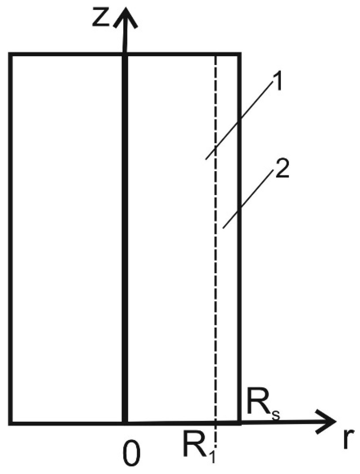
Mathematically, the heat transfer process before the ignition of a deciduous tree trunk is described by partial differential equations of parabolic type with the assignment of the corresponding initial and boundary conditions. Geometric areas are presented in Figure 1.
Unsteady heat conduction equations for core and bark layer:
Initial conditions:
Boundary conditions for the center of tree trunk:
Boundary conditions for the line connected core and bark layer:
Boundary conditions for the external surface of the bark:
where Ti, ρi, ci, λi are the temperature [K], density [kg/m3], heat capacity [J/(kg·K)], and thermal conductivity [W/(m·K)] (i = 1 is the core, i = 2 is the bark layer); t is the temporal coordinate; r is the spatial coordinate; R1 is the border of the core and the bark layer; R is the radius of a deciduous tree; α is the heat transfer coefficient; WWWLLN is the power of the discharge registered by WWLLN; index 0 corresponds to the parameters at the initial moment of time.
The following physical model of the ignition of a coniferous tree by the cloud-to-ground lightning discharge is proposed. A stand-alone coniferous tree, such as pine, is considered. It is believed that the structure of the trunk of a coniferous tree is represented by a resinous core, a moisture-conducting subcrustal layer, and a bark layer. At the moment a lightning discharge strikes a coniferous tree, the electric current of the discharge passes through the subcrustal zone of the tree. The tree trunk heats up as a result of heat generation according to the Joule-Lenz law. As a result of an increase in temperature, the trunk of a coniferous tree is ignited. Additional assumptions: (1) Moisture evaporation from the subcrustal layer is neglected; (2) wood pyrolysis is neglected; (3) the thermophysical characteristics of the core, subcrustal layer and bark layer do not depend on temperature; (4) the monolithic structure of the tree trunk is considered.
Mathematically, the process of heat transfer before the ignition of a coniferous tree trunk is described by partial differential equations of parabolic type with the assignment of the corresponding initial and boundary conditions. Geometric areas are presented in Figure 2.
Unsteady heat conduction equations for core, subcrustal, and bark layer:
Initial conditions:
Boundary conditions for the center of tree trunk:
Boundary conditions for the line connected core and subcrustal layer:
Boundary conditions for the line connected subcrustal and bark layers:
Boundary conditions for the external surface of the bark:
where Ti, ρi, ci, λi are the temperature [K], density [kg/m3], heat capacity [J/(kg·K)], and thermal conductivity [W/(m·K)] (i = 1 is the core, i = 2 is the subcrustal layer, i = 3 is the bark layer); t is the temporal coordinate; r is the spatial coordinate; R1 is the border of the core and subcrustal layer; R2 is the border of the subcrustal and bark layers; R is the radius of the coniferous tree; α is the heat transfer coefficient; WWWLLN is the power of the discharge registered by WWLLN; index 0 corresponds to the parameters at the initial moment of time.
These two models can be compared and contrasted. Both models uses unsteady heat conduction equations to determine temperature distribution in tree trunk. The number of equations is different for coniferous and deciduous tree trunk according to its structure. Boundary conditions are similar for these models but take into account the differences in tree trunk structure for coniferous and deciduous trees.
Moreover, we can single out the probability that forest fuel reaches the state of forest fire maturity. In our case, the “maturation” of the forest fuel is determined by the drying process of the forest fuel layer under the influence of external conditions. This process can be quantitatively characterized by the drying time of the forest fuel layer. The drying time of the forest fuel layer refers to the period of time during which the moisture content of the layer reaches a critical value. For example, for pine needles it is 13%. The drying time of the forest fuel layer makes it possible to determine the probability of forest fires by weather conditions Pj(D).
To determine the value of Pj(D), it should be taken into account that, as a rule, tanning occurs in the daytime. Obviously, Pj(D) takes its maximum value when the time interval up to the prediction hour (as a rule, the occurrence of most fires falls in the middle of the day) coincides with the drying time of the j-th time interval of the fire danger season in the i-th section of the controlled territory. The value of the fire season in days, as a rule, is known from statistical data on the forestry archives. As a result, for the quantity Pj(D), the formula was obtained:
where kh is the correction factor for precipitation accounting (Table 1), tj is the current time; tj* is the drying time of forest fuel to critical value of moisture content; 0 in (15) corresponds to the case when there are no forest fuels on the forest area (the surface of roads, rivers, lakes, and water-saturated swamps). For dry thunderstorms kh = 1 can be used.
To calculate the drying time for a layer of forest fuel material, a deterministic mathematical model presented in [46] was used. This mathematical model takes into account external meteorological conditions, such as wind speed, ambient temperature, long-wave and short-wave solar radiation, heat exchange with the surface layer of the atmosphere and the surface layer of the soil. In addition, this mathematical model takes into account the properties of a specific forest fuel material and therefore, indirectly takes into account the forest growing conditions in the controlled area.

Table 1.
Precipitation coefficient [47].
Table 1.
Precipitation coefficient [47].
| Daily Precipitation, mm | No | 0.1–0.9 | 1.0–2.9 | 3.0–5.9 | 6.0–14.9 | 15.0–19.9 | 20 and More |
|---|---|---|---|---|---|---|---|
| kh | 1.0 | 0.8 | 0.6 | 0.4 | 0.2 | 0.1 | 0.0 |
Below are the main assumptions and suggestions used in the development of a probabilistic criterion for predicting forest fire danger from lightning in mountainous areas:
- -
- In the statistics of forest fires, the vast majority of incidents are caused by lightning activity (this is true for mounting areas remote from settlements);
- -
- Both deciduous and coniferous trees grow in the forested area;
- -
- With increasing altitude, the frequency of cloud-to-ground lightning discharges increases (this is true for mounting areas according to data from WWLLN [45]);
- -
- Average long-term climatic data for the controlled area are used [48];
- -
- Ignition of trees is simulated under the assumption of a thermophysical model;
- -
- Typical tree characteristics are used (thermophysical, geometrical properties) [49].
That is, zero if mathematical modeling showed the absence of ignition of the forest fuels and one if it is numerically established that a forest fuels has ignited.
The probability terms in Equation (20) can be estimated as follows:
where NTF is the total number of days in the fire season; NWWLLN is the number of days that WWLLN recorded lightning activity over the controlled area.
where NTD is the total number of lightning strikes registered by WWLLN; NHC is the number of high energy discharges recorded by the WWLLN.
where AC is the current altitude above sea level, for the controlled wooded area; AMAX is the maximum altitude above sea level for the study region.
It is necessary to rely on the rigorous mathematical results of risk analysis [50], when the threat of any catastrophic phenomenon is assessed by its probability. The following probabilistic criterion for forest fire danger caused by lightning activity is proposed:
where Pj is the probability of a forest fire from lightning activity for the j-th day of the fire-dangerous season; P(M) is the probability of lightning activity in the controlled forest-covered area; P(Mj/M) is the probability of the cloud-to-ground lightning discharges in the controlled forest-covered area; P(L) is the probability of the cloud-to-ground lightning discharge hitting an area above a certain height above sea level; P(FF/M,Mj,L) is the probability of ignition of a forest fuels as a result of the cloud-to-ground lightning discharge, provided that the lightning front passes over the forest-covered area above a certain height above sea level.
Probabilistic part (5) also takes into account the dependence of ignition probability on forest growth conditions and meteorological data during first part of the day according to mathematical model to calculate dry time of forest fuel layer under the external meteorological conditions [46].
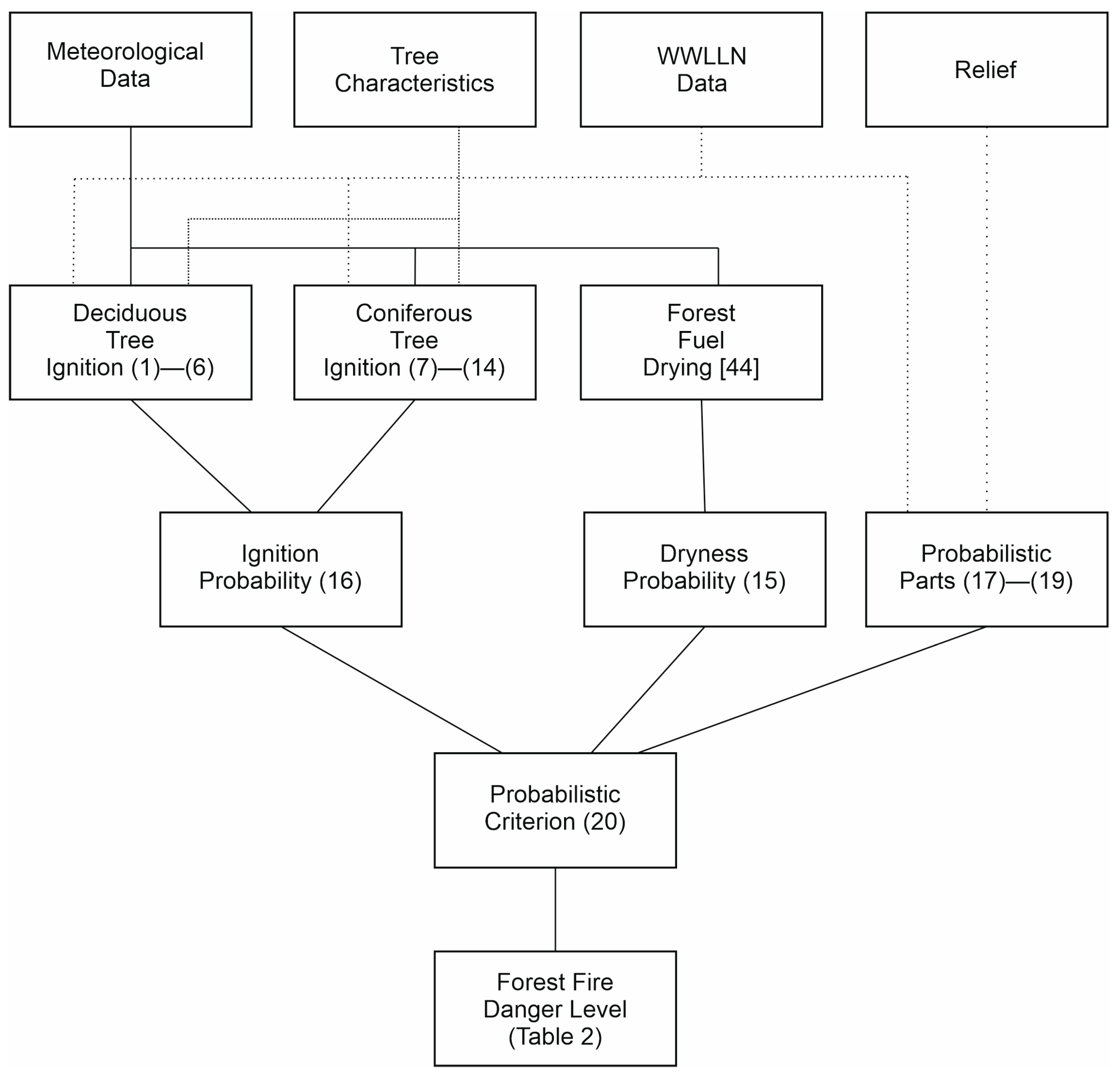
Suggested approach consists of two interconnected parts: probabilistic criterion that formulated in Equations (15)–(20) and two deterministic models to calculate ignition conditions for coniferous and deciduous trees presented in Equations (1)–(6) and Equations (7)–(14). This approach to predict forest fire danger can be described as Figure 3. First stage is a setup of initial conditions. Four types of initial conditions are considered, namely, meteorological data, tree characteristic, WWLLN data, and relief. Next stage is computing of ignition conditions for coniferous and deciduous trees accompanied with calculation of probabilistic part (17)–(19). Next stage is calculation of probabilistic criterion and determination of forest fire probability according to (20). Finally, probability of forest fire occurrence can be presented as five subintervals of [0, 1] range: extreme, high, medium, low, very low, or none.
Forest fire danger scale has been presented in Table 2.
In this paper, it is proposed to use synthetic data on the parameters of lightning activity, since this is a pioneering work on using the deterministic-probabilistic method to predict forest fire dangers in mountainous areas, not all statistical data are currently available. It is proposed to identify a group of parameters that will serve as input data for assessing the probability of a forest fire on a typical day of a fire dangerous season.
Three scenarios of forest fire danger are considered for each territory. Below are the main scenarios for the occurrence of forest fires from lightning in mountainous areas. Table 3 shows the typical scenarios that characterize lightning activity. Scenarios of low, moderate, and high forest fire danger are considered. These scenarios differ in the length of the fire season, the number of days with lightnings, and the typical number of high energy discharges. According to [51], it can be assumed that it is the high-energy discharges that will be cloud-to-ground discharges. It should be noted that at the moment the World Wide Lightning Location Network does not provide data on the type of lightning discharge, but makes it possible to use the geographical coordinates and energy characteristics of the lightning discharge [52]. Three types of scenarios for lightning activity are considered: Low, Moderate, and High.
The work uses data from the WWLLN for 2010–2015. The nearest five WWLLN stations to Gorno-Altaysk and Ulan-Ude until 2015 are Bryansk (≈3200 km), Yakutsk (≈2600 km), Beijing (≈2900 km), Lanzhou (≈2700 km), Vladivostok (≈3600 km). The network registers data throughout the year. Data on atmospheres recorded by WWLLN contain the following indicators: date, time, latitude, longitude, error, and number of stations in which the electromagnetic pulse was recorded [53].
The time of registration of the lightning discharge by the WWLLN network is carried out at a worldwide coordinated time. To estimate the daily stroke of the lightning discharges, the time was recalculated for each discharge from the universal coordinated time to the local solar time. An analysis of the lightning-density distribution map is presented, which was calculated from the number of atmospherics recorded by the WWLLN in 10 km × 10 km sections [54].
The WWLLN receiver consists of a VLF antenna, a VLF preamplifier (mounted at the bottom of the antenna). A separate small GPS antenna is also installed. In addition, a service node is connected. All these components are connected to a personal computer using various cables [55,56].
It should be noted that such a node can be built in any country to detect lightning discharges at a distance of up to 10 thousand km. The maximum signal from a lightning strike is fixed at frequencies around 10 kHz. Each node transmits data to the central computer, where centralized data processing takes place.
Membership in the WWLLN network is not limited to any political requirements. The WWLLN network nodes work on volunteer basis. The network is really international. The optimal distance is 3000 km from node to the node for detecting lightning discharges. For the functioning of the node, a Pentium III or more powerful processor is sufficient. It should be noted that the sound card can be either integrated in the motherboard, or made in a separate version (the parameters of the sound card affect the passage of the signal through the sound channel). The personal computer of the node can operate under a Windows or Unix system. The node installed in Gorno-Altaysk State University operates under the control of the Ubuntu system [55,56].
Table 2.
Forest fire danger scales (level).
| Fire Danger Class, Pj | Regulations for Forest Protection Services [57] |
|---|---|
| Pj ∈ [0, 0.2], (I) No fire danger | Ground-based patrols are carried out in places of flammable work, in order to monitor compliance with fire safety rules in the forest. Duty on fire observation towers (FOT) is not carried out. |
| Pj ∈ (0.2, 0.4], (II) Lowfire danger | Ground patrolling is carried out in areas assigned to classes I and II of natural fire danger, as well as in places of mass visits and rest of the population from 11 to 17 h. Duty at the night vision gates and at reception points from 11 to 17 h. |
| Pj ∈ (0.4, 0.6], (III) Medium fire danger | Ground patrolling is carried out from 10 to 19 h, in areas assigned to the first three classes of fire danger, and is especially intensified in the places of work and places most visited by the population. Duty at the FOT and at points of reception of reports from 10 to 19 h, at points of reception of reports from 10 to 17 h. |
| Pj ∈ (0.6, 0.8], (IV) High fire danger | Ground patrolling is carried out from 8 to 20 h in places of work, as well as in places visited by the population, regardless of the class of fire danger to which the sections are assigned. Duty hours on FOT are carried out during the whole daylight hours, at the points of reception of reports from 8 to 20 h. |
| Pj ∈ (0.8, 1], (V) Extreme fire danger | Ground patrolling is carried out throughout the daylight hours, and in the most dangerous places around the clock. To help the forest guard and temporary firemen, workers and employees of the forestry, a public asset and the police are involved in patrolling. Duty on FOT and at points of reception of reports are carried out, as in the IV class of fire danger. |
Table 3.
Influence of characteristics of lightning activity.
| Scenario | NTF | NWWLLN | NHC | NTD | AC, m | AMAX, m | WWWLLN, MW |
|---|---|---|---|---|---|---|---|
| Altay Republic, Low | 200 | 25 | 20 | 100 | 1000 | 4000 | 2500 |
| Altay Republic, Moderate | 200 | 30 | 25 | 100 | 1000 | 4000 | 2500 |
| Altay Republic, High | 200 | 35 | 30 | 100 | 1000 | 4000 | 2500 |
| Republic of Buryatiya, Low | 160 | 20 | 20 | 100 | 1000 | 2683 | 2500 |
| Republic of Buryatiya, Moderate | 160 | 25 | 25 | 100 | 1000 | 2683 | 2500 |
| Republic of Buryatiya, High | 160 | 30 | 30 | 100 | 1000 | 2683 | 2500 |
* WWLLN is World Wide Lightning Location Network, MAX is maximum.
Table 3 provides information on different scenarios of lightning activity for Republic of Buryatiya and Republic of Altay. Three scenarios are considered. Low lightning activity is characterized by the lowest number of days with lightning discharges registered by WWLLN network. Each parameter is fixed for a specified scenario. Moreover, it should be noted that fire dangerous season length is different for each study area.
Table 4 presents typical scenarios that characterize the altitudinal zonation of a forested area. Scenarios of low, moderate, and high forest fire danger are also considered. The main predictor in this table is the elevation of a typical wooded area relative to sea level. Three scenarios are considered. Low lightning activity is characterized by lowest altitude of forested area. Each parameter is fixed for a specified scenario. Moreover, it should be noted that fire dangerous season length is different for each study area.
Table 5 provides descriptions of scenarios for the ignition of a forest fuels, namely, the trunk of a deciduous or coniferous tree by an electric current of the cloud-to-ground lightning discharge. The main predictor in this table is the power of the cloud-to-ground lightning discharge. Three scenarios of forest fire danger are presented in accordance with the magnitude of the power of a cloud-to-ground lightning discharge. Each parameter is fixed for a specified scenario. Furthermore, it should be noted that fire dangerous season length is different for each study area.
4. Results and Discussion
It should be noted that the results of experiments to determine the kinetic mechanism (and its parameters) of the ignition of large wood blocks (including a high-energy electric discharge) are still unknown. The difficulty of implementing an experimental study of this process is obvious. However, there is an approach [58], within which the conditions of ignition of deciduous wood (birch) are described by two parameters (heat flow and temperature of the ignition surface, Table 6 and Table 7).
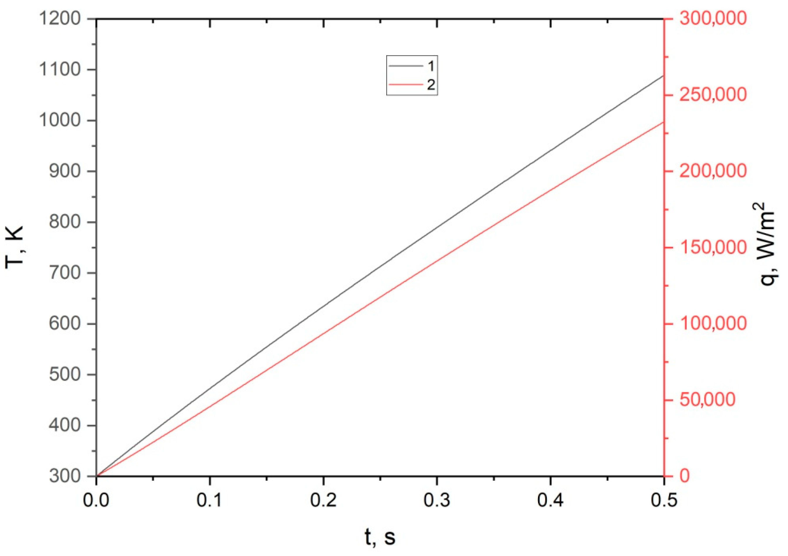
The distribution of temperature along the radius of the trunk of a deciduous tree without taking into account the surface layer of water at different points in time during the action of a lightning discharge is shown in Figure 4: (1) t = 0.01 s; (2) 0.1 s; (3) 0.3 s; (4) 0.5 s. Figure 5 shows the dependence of the temperature of the ignition surface and the density of the heat flux to this surface on time.
In Figure 5, numbers indicate: 1—temperature in the trunk at the border of the bark and core; 2—temperature on the surface of the bark during heat release in the surface layer of water; 3—heat flux to the ignition surface from the trunk core; 4—heat flux to the ignition surface from the surface layer of water. The ignition conditions were determined from the experimental data [58] (Table 6).
Figure 6 shows the temperature distribution along the radius of a tree trunk at various points in time before and at the time of ignition of a tree trunk by electric current: (1) t = 0.01 s; (2) 0.1 s; (3) 0.3 s; (4) 0.5 s. Figure 7 shows the time dependence of the heat flux from the subcortical zone to the ignition surface of the tree trunk and the temperature of this boundary at various points in time. The ignition conditions of the trunk wood were determined by experimental data [58] (Table 7):
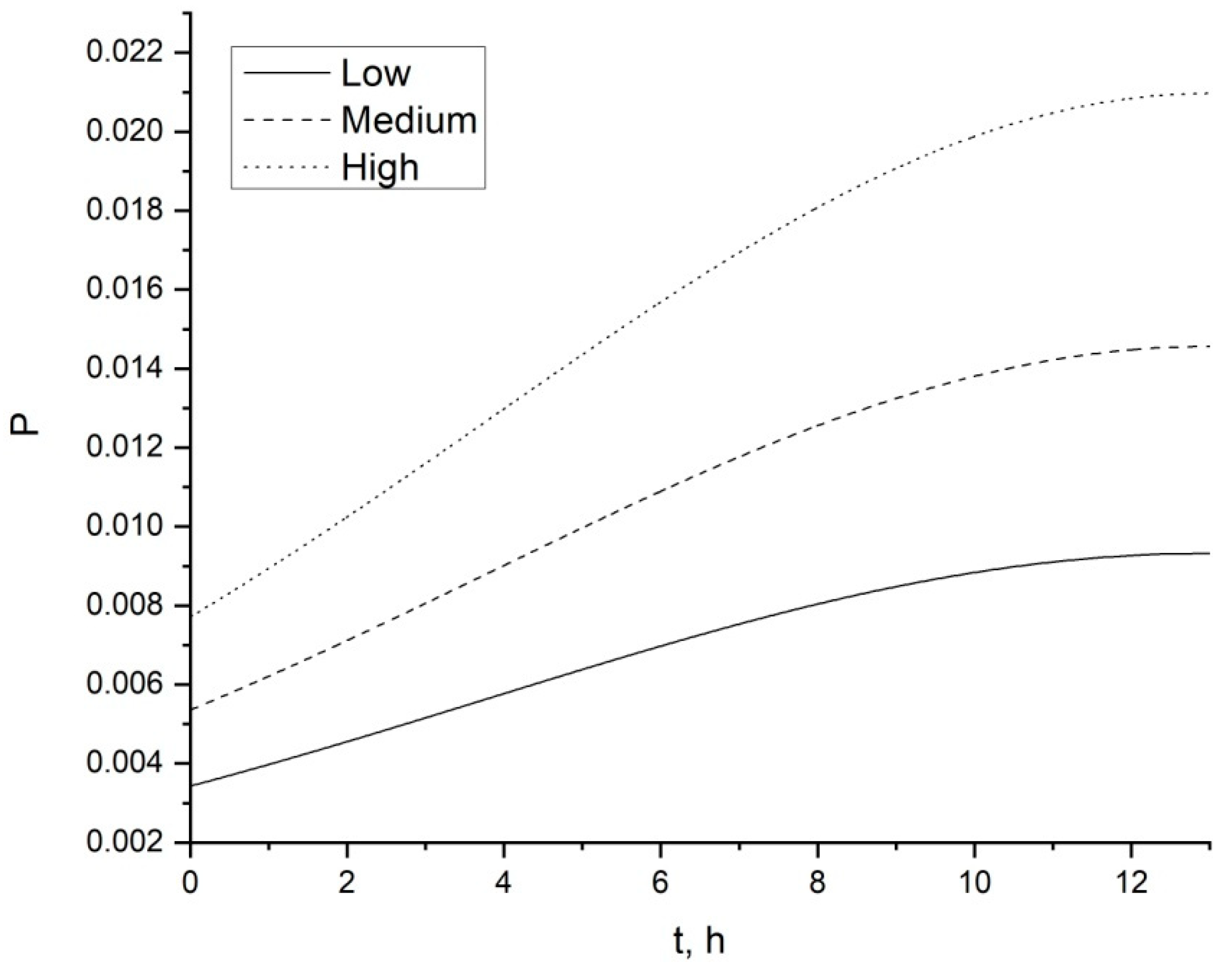
Figure 8 shows the dependence of the probability of a forest fire as a result of the cloud-to-ground lightning discharge on the territory of the Altai Republic during the first half of the day according to Table 2. Low, moderate, and high scenarios of lightning activity are considered.
The curves of the probability of forest fire occurrence, typical for scenarios of low, moderate, and high forest fire danger, are presented. The time interval is considered from midnight to 13 o’clock in the afternoon. The choice of this time interval is due to a number of forest fire danger factors. It is known [2] that most of cloud-to-ground lightning discharges occur at night. This determines the choice of the lower time limit around midnight. Second, from the morning hours until 13:00 there is an intensive evaporation of moisture from forest fuels [46]. It is at 13 o’clock in the afternoon that the peak of forest fire danger caused by meteorological conditions is usually observed [50]. Therefore, it is important for forest fire protection services to understand what level of forest fire danger will be by 13 o’clock local time.
Figure 9 shows the dependence of the probability of a forest fire as a result of the cloud-to-ground lightning discharge on the territory of the Republic of Buryatia in the first half of the day according to Table 2. Low, moderate, and high scenarios of lightning activity are considered.
Figure 9 also shows curves typical for scenarios of low, moderate, and high forest fire danger. Similarly, the calculation of the probability was carried out from midnight to 13:00 local time.
Figure 10 shows the dependence of the probability of a forest fire, due to the altitude of the forested area above sea level when exposed to the cloud-to-ground lightning discharge for the Altay Republic according to Table 3. Low, moderate, and high scenarios of lightning activity are considered.
Figure 10 shows curves typical for scenarios of low, moderate, and high forest fire danger. The choice of the characteristics of various scenarios is due to the fact that it was previously established that large values of the cloud-to-ground discharge current and their number are characteristic of higher mountainous regions [46].
Figure 11 shows the dependence of the probability of a forest fire, due to the height of the forested area above sea level when exposed to the cloud-to-ground lightning discharge for the Republic of Buryatia according to Table 3. Low, moderate, and high scenarios of lightning activity are considered.
Figure 11 also shows curves typical for different scenarios of forest fire danger.
Figure 12 shows a binary diagram of the probability of ignition for deciduous or coniferous tree trunk by the cloud-to-ground lightning discharge current according to Table 4. Typical range of lightning discharge magnitude is used for calculations.
The value of the probability of ignition for tree trunk for synthetic data turned out to be the same for similar scenarios of ignition by the cloud-to-ground lightning discharge, for both deciduous and coniferous trees. It is clear that with the same energy characteristics, the probability of ignition of a tree trunk by the cloud-to-ground lightning discharge will be the same both for the territory of the Altay Republic and for the territory of the Republic of Buryatia.
Separately, it is necessary to characterize the processes of ignition of deciduous and coniferous trees by the cloud-to-ground lightning discharge. Despite the fact that in the presented calculations using a one-dimensional mathematical formulation for deciduous and coniferous trees, the ignition conditions turned out to be the same, in reality there will be differences. As studies of the processes of ignition of deciduous and coniferous trees by the cloud-to-ground lightning discharge in two-dimensional and three-dimensional formulations have shown [50], the ignition delays and conditions themselves will slightly differ. First, this is due to the geometric and structural heterogeneity of the trunk of deciduous and coniferous trees [59].
In a deciduous tree, the trunk can be conditionally divided into two layers, represented by the core and the bark layer. The core contains vessels that conduct moisture. Ignition is susceptible to inter-vessel wood near the surface vessels. Since it is possible to access oxygen in the air, at certain concentrations of oxygen and gaseous pyrolysis products and the temperature of the gas mixture, gas-phase ignition of the tree trunk occurs. With the passage of an electric current in internal vessels, both thermal stresses and processes of intense vaporization can arise. Together, these processes can cause the trunk of a deciduous tree to rupture. Calculation based on two-dimensional and three-dimensional mathematical formulations [50] shows that the ignition of the trunk occurs in the zone of localization of cracks in the bark layer.
The structure of the coniferous tree is somewhat different [59]. In the trunk of a coniferous tree, three zones can be distinguished: the resinous core, the subcrustal layer, and the bark. Moisture in the trunk of a coniferous tree moves in a narrow subcrustal zone. It is here that the Joule heat is released and the subsequent ignition of the coniferous tree trunk occurs. Moreover, the same physicochemical processes are characteristic that occur in deciduous trees. However, thermal stresses and intense vaporization occur in a narrow subcrustal zone. Therefore, for a coniferous tree, the breakdown of the bark layer is more characteristic. The heated or burning fragments of the bark fall out onto the layer of the ground combustible material and can lead to its ignition [50]. As a result, a surface forest fire occurs.
It is also necessary to characterize the results obtained for assessing the probability of a forest fire for various scenarios of forest fire danger. Analysis of Figure 8 and Figure 9 shows that the absolute probabilities of a forest fire as a result of the impact of the cloud-to-ground lightning discharge are quite small. However, this value is not null. These values are comparable both for the territory of the Altay Republic and for the territory of the Republic of Buryatia. The differences in the numerical values are due to the difference in the duration of the fire dangerous season and the parameters of lightning activity. Figure 8 and Figure 9 show that the maximum probability of a forest fire is typical for noon. Earlier it was indicated, what caused this pattern. A comparative analysis of various scenarios shows a natural increase in the probability of a forest fire for a scenario of high forest fire danger compared to scenarios of low and moderate danger.
Analysis of Figure 10 and Figure 11 shows that when the forested area is located at a higher altitude relative to sea level, the probability of a forest fire is also higher. This is clearly seen in the curves corresponding to scenarios of low, moderate, and high forest fire danger. The absolute values of the probability of a forest fire are also comparable for the territory of the Altay Republic and the territory of the Republic of Buryatia.
It should be noted that the probability of a forest fire is comparable to the proportion of trees ignited during a lightning discharge [15,16,17,18,19,20,21,22,23,24]. Thus, parametric analysis and scenario modeling show the adequacy of the change in the probability of a forest fire when the initial data included in the formula of the probabilistic criterion are varied. It should be noted that the obtained formula for assessing the probability of a forest fire as a result of the cloud-to-ground lightning discharge can be used in conjunction with the methodology for predicting the number of forest fires [60].
It should also be added that since 2011, a simpler probabilistic formula has been used in ISDM-Rosleskhoz in the Russian Federation [5]. This criterion uses statistics on the occurrence of forest fires. The development of a new probabilistic criterion for predicting forest fires, presented in this work, will allow in the near future to modernize the block for calculating the probability of forest fires from lightnings in ISDM-Rosleskhoz, taking into account the real data on cloud-to-ground lightning discharges and in mountainous terrain. This study is part of two large projects to develop methods for predicting forest fire dangers. Within the framework of the first regional project on the territory of the Altay Republic, next year, it is planned to collect statistics on forest fires in forestry and conduct a retrospective analysis of the developed probabilistic criterion for the occurrence of forest fires, taking into account statistics on the occurrence of forest fires and real data on lightning discharges registered by the WWLLN system. Prospects for development within the framework of the second project with the support of JSC Russian Railways are due to a joint analysis of the conditions for the occurrence of forest fires from lightnings and the impact of the railway in buffer zones on the territory of the Republic of Buryatia. It should be noted that the question of how to divide the interval of change in the probability of a forest fire into five subintervals corresponding to different levels of forest fire danger remains open. They will probably be uneven.
5. Conclusions
Thus, in this work, we propose an integrated deterministic-probabilistic approach to predicting forest fire dangers due to lightning activity in mountainous terrain. As a result of the study, a probabilistic criterion for assessing the occurrence of a forest fire caused by the impact of the cloud-to-ground lightning discharge has been developed. Scenario modeling and parametric analysis made it possible to establish that the calculated probability of a forest fire occurrence adequately reflects the change in the initial data. Moreover, consistent results were obtained for scenarios of low, moderate, and high lightning activity.
A quantitative analysis shows that, depending on the local time, the duration of the fire dangerous season, the characteristics of lightning activity and the topography of the study area, the probability of a forest fire is about 0.01–0.02 in absolute terms. These values are similar to the percentage of trees ignited by the cloud-to-ground lightning discharges. As a result of research [30], it was found that the efficiency of a thunderstorm (the number of forest fires to the number of lightning discharges) for Catalonia is about 1/400. Thus, only a few discharges lead to a forest fire and the development of methods for identifying potential discharges that will lead to a fire, among the total number, is very important for predicting forest fire hazards caused by a thunderstorm [30].
Thus, this paper presents a deterministic-probabilistic approach to predicting forest fire danger due to thunderstorm activity. The deterministic part is based on physical and mathematical models of forest fuel drying and ignition of coniferous and deciduous trees by a cloud-to-ground lightning discharge. Heat transfer in a tree trunk under the influence of a cloud-to-ground lightning discharge is described mathematically using the unsteady heat conduction equations with the corresponding initial and boundary conditions. These equations are solved by the finite difference method. As a result of numerical modeling, the conditions for the ignition of a tree can be determined: the temperature of the ignition surface and the heat flux from the heat release zone in the tree trunk to the bark layer. At certain values of these parameters, which are presented in Table 6 and Table 7, the ignition of a tree trunk by a cloud-to-ground lightning discharge can be fixed. Using Equation (16), one can determine the binary dependence of the ignition probability. The final probability of a forest fire depends on time, since the probabilistic part (15) is calculated using a mathematical model of forest fuel drying. Such a model describes the evaporation of moisture from a forest fuel under the influence of external meteorological conditions and depends on the time coordinate.
The paper proposes to use a forest fire probability scale in accordance with Table 2. However, as a result of calculating the values of the final probability, they are very small and, perhaps, one should speak not about the level of forest fire danger, but about the probability of ignition as a result of a cloud-to-ground lightning discharge. As is known, not all cloud-to-ground discharges lead to the ignition of forest fuel, and not all ignitions pass into the stage of stable flame propagation, which is characteristic for a surface forest fire. The issue of forest fire danger scales should be worked out in subsequent studies using real data for a specific period of the definite fire season.
Further studies will be aimed at conducting a retrospective analysis of the obtained probabilistic criterion for the occurrence of a forest fire using statistical data and parameters of lightning activity recorded by the WWLLN network. This will allow in the future to validate the developed probabilistic criterion.
Funding
The reported study was funded by RFBR. Project number 20-45-040012 (synthetic modeling for Republic of Altay). The reported study was funded by RFBR, Sirius University of Science and Technology, JSC Russian Railways and Educational Fund “Talent and success”, project number 20-31-51001 (synthetic modeling for Republic of Buryatiya). The APC was funded by MDPI.
Institutional Review Board Statement
Not applicable.
Informed Consent Statement
Not applicable.
Data Availability Statement
Data can be provided by the request for author.
Conflicts of Interest
The author declares no conflict of interest.
References
- Baranovskiy, N.V. Predicting, Monitoring, and Assessing Forest Fire Dangers and Risks. IGI Glob. 2020. [Google Scholar] [CrossRef]
- Ivanov, V.A. Methodological Foundations of the Classification of Forests in Central Siberia by the Degree of Fire Danger from Lightnings. Ph.D. Thesis, SibSTU, Krasnoyarsk, Russia, 2006; p. 350. (In Russian). [Google Scholar]
- Wang, X.; Wotton, B.M.; Cantin, A.S.; Parisien, M.-A.; Anderson, K.; Moore, B.; Flannigan, M.D. cffdrs: An R package for the Canadian Forest Fire Danger Rating System. Ecol. Process. 2017, 6, 5. [Google Scholar] [CrossRef]
- WFAS: Wildland Fire Assessment System. Available online: https:www.wfas.net/ (accessed on 10 August 2021).
- Podolskaya, A.S.; Ershov, D.V.; Shulyak, P.P. Application of the method for assessing the likelihood of forest fires in ISDM-Rosleskhoz. Mod. Probl. Remote Sens. Earth Space 2011, 8, 118–126. (In Russian) [Google Scholar]
- Muller, M.M.; Vila-Vilardell, L.; Vacik, H. Towards an integrated forest fire danger assessment system for the European Alps. Ecol. Inform. 2020, 60, 101151. [Google Scholar] [CrossRef]
- Wastl, C.; Schunka, C.; Lüpkea, M.; Cocca, G.; Conedera, M.; Valese, E.; Menzel, A. Large-scale weather types, forest fire danger, and wildfire occurrence in the Alps. Agric. For. Meteorol. 2013, 168, 15–25. [Google Scholar] [CrossRef]
- Grishin, A.M.; Filkov, A.I. A deterministic-probabilistic system for predicting forest fire danger. Fire Saf. J. 2011, 46, 56–62. [Google Scholar] [CrossRef]
- Nesterov, V.G. Combustibility of the Forest and Methods of Its Determination; Goslesbumizdat: Moscow, Russia, 1949; p. 76. (In Russian) [Google Scholar]
- Nieto, H.; Aguado, I.; Garcia, M.; Chuvieco, E. Lightning-caused fires in Central Spain: Development of a probability model of occurrence for two Spanish regions. Agric. For. Meteorol. 2012, 162–163, 35–43. [Google Scholar] [CrossRef] [Green Version]
- Titaev, P.S. Simulation model of the probability of forest fires taking into account lightning activity and anthropogenic factor. Fire Explos. Saf. 2015, 24, 44–53. (In Russian) [Google Scholar]
- Baranovskiy, N.V.; Kuznetsov, G.V.; Nemova, T.N. Mathematical computing of coniferous tree ignition by the cloud-to-ground lightning discharge using Joule-Lenz’s law. Int. J. Electr. Comput. Eng. 2017, 7, 1337–1346. [Google Scholar] [CrossRef] [Green Version]
- Kuznetsov, G.V.; Baranovskiy, N.V. Focused sun’s rays and forest fire danger: New concept. Proc. SPIE-Int. Soc. Opt. Eng. 2013, 8890, 889011. [Google Scholar]
- Baranovskiy, N.V. Mathematical modeling for the forest fuel layer ignition caused by focused solar radiation flux. Proc. SPIE-Int. Soc. Opt. Eng. 2015, 9680, 96805L. [Google Scholar]
- Muller, M.M.; Vacik, H. Characteristics of lightnings igniting forest fires in Austria. Agric. For. Meteorol. 2017, 240–241, 26–34. [Google Scholar] [CrossRef]
- Lee, B.S.; Alexander, M.E.; Hawkes, B.C.; Lynham, T.J.; Stocks, B.J.; Englefield, P. Information systems in support of wildland fire management decision making in Canada. Comput. Electron. Agric. 2002, 37, 185–198. [Google Scholar] [CrossRef]
- Diendorfer, G. Lightning location system (LLS). In Proceedings of the IX International Symposium on Lightning Protection, Foz do Iguacu, Brazil, 26–30 November 2007. [Google Scholar]
- Schulz, W.; Cummins, K.L.; Diendorfer, G.; Dorninger, M. Cloud-to-ground lightning in Austria: A 10-year study using data from a lightning location system. J. Geophys. Res. 2005, 110, D9. [Google Scholar] [CrossRef]
- Austrian Lightning Detection and Information System (ALDIS). Lightning Statistics Austria. 2009. Available online: http:www.aldis.at (accessed on 27 July 2021).
- Biagi, C.J.; Cummins, K.L.; Kehoe, K.E.; Krider, P.E. National Lightning Detection Network (NLDN) performance in southern Arizona, Texas and Oklahoma in 2003–2004. J. Geophys. Res. 2007, 112, D05208. [Google Scholar] [CrossRef] [Green Version]
- Castedo-Dorado, F.; Rodriguez-Perez, J.R.; Marcos-Menendez, J.L.; Alvarez-Taboada, M.F. Modelling the probability of lightning-induced forest fire occurrence in the province of Leon (NW Spain). For. Syst. 2011, 20, 95–107. [Google Scholar] [CrossRef] [Green Version]
- Outcalt, K.W. Lightning, fire and longleaf pine: Using natural disturbance to guide management. For. Ecol. Manag. 2008, 255, 3351–3359. [Google Scholar] [CrossRef] [Green Version]
- Podur, J.; Martell, D.L.; Csillag, F. Spatial patterns of lightning caused forest fires in Ontario, 1976–1998. Ecol. Model. 2003, 164, 1–20. [Google Scholar] [CrossRef]
- Schulz, W. Location accuracy improvements of the Austrian lightning location system during the last 10 years. In Proceedings of the 9th Asia-Pacific International Conference on Lightning (APL), Nagoya, Japan, 23–27 June 2015. [Google Scholar]
- Vecin-Arias, D.; Castedo-Dorado, F.; Ordonez, C.; Rodriguez-Perez, R.J. Biophysical and lightning characteristics drive lightning-induced fire occurrence in the central plateau of the Iberian Peninsula. Agric. For. Meteorol. 2016, 225, 36–47. [Google Scholar] [CrossRef]
- Krawchuk, M.A.; Cumming, S.G.; Flannigan, M.D.; Wein, R.W. Biotic and abiotic regulation of lightning fire initiation in the mixedwood boreal forest. Ecology 2006, 87, 458–468. [Google Scholar] [CrossRef]
- Verdu, F.; Salas, J.; Vega-Garcia, C. A multivariate analysis of biophysical factors and forest fires in Spain, 1991–2005. Int. J. Wildland Fire 2012, 21, 498–509. [Google Scholar] [CrossRef]
- Moris, J.V.; Conedera, M.; Nisi, L.; Bernardi, M.; Cesti, G.; Pezzatti, G.B. Lightning-caused fires in the Alps: Identifying the igniting strokes. Agric. For. Meteorol. 2020, 290, 107990. [Google Scholar] [CrossRef]
- European Cooperation for Lightning Detection (EUCLID). Available online: http:www.euclid.org (accessed on 27 July 2021).
- Pineda, N.; Rigo, T. The rainfall factor in lightning-ignited wildfires in Catalonia. Agric. For. Meteorol. 2017, 239, 249–263. [Google Scholar] [CrossRef]
- Marshall, J.S.; Radhakant, S. Radar precipitation maps as lightning indicators. J. Appl. Meteorol. 1978, 5, 165–166. [Google Scholar] [CrossRef]
- Sheridan, S.C.; Griffiths, J.F.; Orville, R.E. Warm season cloud-to-ground lightning-precipitation relationships in the south-central United States. Weather. Predict. 1997, 12, 449–458. [Google Scholar] [CrossRef]
- Petersen, W.A.; Rutledge, S.A. On the relationship between cloud-to-ground lightning and convective rainfall. J. Geophys. Res. 1998, 103, 14025–14040. [Google Scholar] [CrossRef]
- Soula, S.; Chauzy, S. Some aspects of the correlation between lightning and rain activities in lightnings. Atmos. Res. 2001, 56, 355–373. [Google Scholar] [CrossRef]
- Pineda, N.; Rigo, T.; Bech, J.; Soler, X. Lightning and precipitation relationship in summer lightnings: Case studies in the north western Mediterranean region. Atmos. Res. 2007, 85, 159–170. [Google Scholar] [CrossRef]
- Xie, Y.; Xu, K.; Zhang, T.; Liu, X. Five-year study of cloud-to-ground lightning activity in Yunnan province, China. Atmos. Res. 2013, 129–130, 49–57. [Google Scholar] [CrossRef]
- Chan, H.G.; Mohamed, A.I.B. Investigation on the occurrence of positive cloud-to-ground (+CG) lightning in UMP Pekan. J. Atmos. Sol. Terr. Phys. 2018, 179, 206–213. [Google Scholar] [CrossRef]
- Suparta, W.; Adnan, J.; Alauddin, M.; Ali, M. Monitoring the association between GPS PWV and lightning activity during the 2009 Winter Monsoon over Bangi Malaysia. In Proceedings of the 2011 International Conference on Environment Science and Engineering IPCBEE, Bail Island, Indonesia, 1–3 April 2011; Volume 8, pp. 101–106. [Google Scholar]
- Aranguren, D.; Lopez, J.; Inampues, J.; Torres, H.; Betz, H. Cloud-to-ground lightning activity in Colombia and the influence of topography. J. Atmos. Sol. Terr. Phys. 2017, 154, 182–189. [Google Scholar] [CrossRef]
- Holler, H.; Betz, H.D.; Schmidt, K.; Calheiros, R.; May, P.; Houngninou, E.; Scialom, G. Lightning characteristics observed by a VLF/LF lightning detection network (LINET) in Brazil, Australia, Africa and Germany. Atmos. Chem. Phys. 2009, 9, 7795–7824. [Google Scholar] [CrossRef] [Green Version]
- Betz, H.D.; Schmidt, K.; Oettinger, W.P.; Wirz, M. Lightning detection with 3D-discrimination of intra-cloud and cloud-to-ground discharges. J. Geophys. Res. Lett. 2004, 31, L11108. [Google Scholar] [CrossRef]
- Betz, H.D.; Schmidt, K.; Fuch, B.; Oettinger, W.P.; Holler, H. Cloud lightning: Detection and utilization for total lightning measured in the VLF/LF regime. J. Lightning Res. 2009, 2, 1–17. [Google Scholar]
- Badmaev, N.B.; Bazarov, A.V.; Sychev, R.S. Forest Fire Danger Assessment Using Meteorological Trends: Case Study. In Predicting, Monitoring, and Assessing Forest Fire Dangers and Risks; Baranovskiy, N., Ed.; IGI Global: Hershey, PA, USA, 2020; pp. 183–208. [Google Scholar]
- Badmaev, N.; Bazarov, A. Correlation analysis of terrestrial and satellite meteodata in the territory of the Republic of Buryatia (Eastern Siberia, Russian Federation) with forest fire statistics. Agric. For. Meteorol. 2021, 297, 108245. [Google Scholar] [CrossRef]
- Emercom for Republic of Altay. Available online: https:04.mchs.gov.ru/ (accessed on 14 September 2021).
- Grishin, A.M.; Baranovskij, N.V. Comparative analysis of simple models of drying of the layer of forest combustibles, including the data of experiments and natural observations. Inzhenerno-Fiz. Zhurnal 2003, 76, 166–169. [Google Scholar] [CrossRef]
- Zhdanko, V.A.; Gritsenko, M.V. Method of Analysis of Forest Fire Seasons, Practical Recommendations; LenNIILH: Leningrad, Russia, 1980. (In Russian) [Google Scholar]
- Scientific and Applied Reference Book on the Climate of the USSR. Series 3. Long-Term Data. Parts 1-6. Issue 20. In Tomsk, Novosibirsk, Kemerovo Regions and Altai Territory; Gidrometeoizdat: St. Petersburg, Russia, 1993; p. 718. (In Russian) [Google Scholar]
- Abaimov, V.F. Dendrology; Academy: Moscow, Russia, 2009. (In Russian) [Google Scholar]
- Baranovskiy, N.V. (Ed.) Forest Fire Danger Prediction Using Deterministic-Probabilistic Approach; IGI Global: Hershey, PA, USA, 2020. [Google Scholar]
- Karanina, S.Y.; Baranovskiy, N.V.; Karanin, A.V.; Belikova, M.Y. Estimation of Return-Stroke Peak Current of Lightning Strokes Registered by WWLLN: A Case Study. Int. Rev. Electr. Eng. 2021, 16, 275–285. [Google Scholar]
- Hutchins, M.L.; Holzworth, R.H.; Rodger, C.J.; Brundell, J.B. Far-field power of lightning strokes as measured by the World Wide Lightning Location Network. J. Atmos. Ocean. Technol. 2012, 29, 1102–1110. [Google Scholar] [CrossRef]
- World Wide Lightning Location Network. Available online: https:wwlln.net/ (accessed on 15 September 2021).
- Karanina, S.Y.; Kocheeva, N.A.; Belikova, M.Y.; Baranovskiy, N.V. Analysis of a thunderstorm activity according to WWLLN: A case study. Int. Rev. Electr. Eng. 2018, 13, 69–79. [Google Scholar] [CrossRef]
- WWLLN Handbook for Setting up the WWLLN station. Available online: wwlln.net/WWLLN_Stn_Hbook_2011.pdf (accessed on 26 December 2017).
- Hardware for a WWLLN site. Available online: http:webflash.ess.washington.edu/Hardware_for_a_WWLLN_site1.pdf (accessed on 26 December 2017).
- Shchetinsky, E.A. Extinguishing Forest Fires: A Guide for Forest Firefighters, 3rd ed.; Federal Forest Service of the Russian Federation: Moscow, Russia, 2002; p. 104. (In Russian) [Google Scholar]
- Zabolotny, A.E.; Zabolotnaya, M.M.; Zabolotnaya, Y.A.; Timoshin, V.N. Determination of safe use zones of solid fuel generators of fire extinguishing aerosols. Issues Spec. Eng. 1995, 7–8, 15–21. (In Russian) [Google Scholar]
- Esau, K. Anatomy of Seed Plants; Wiley: Hoboken, NJ, USA, 1977; p. 576. [Google Scholar]
- Baranovskiy, N.V. Predicting Forest Fire Numbers Using Deterministic-Probabilistic Approach. In Predicting, Monitoring, and Assessing Forest Fire Dangers and Risks; Baranovskiy, N., Ed.; IGI Global: Hershey, PA, USA, 2020; pp. 89–100. [Google Scholar]
Figure 1.
Decision area for deciduous tree trunk: 1—core; 2—bark layer; R1—boundary between core and bark layer; Rs—tree trunk radius.
Figure 1.
Decision area for deciduous tree trunk: 1—core; 2—bark layer; R1—boundary between core and bark layer; Rs—tree trunk radius.

Figure 2.
Decision area for coniferous tree trunk: 1—core; 2—subcrustal layer; 3—bark layer; R2—boundary between core and subcrustal layer; R1—boundary between subcrustal and bark layer; Rs—tree trunk radius.
Figure 2.
Decision area for coniferous tree trunk: 1—core; 2—subcrustal layer; 3—bark layer; R2—boundary between core and subcrustal layer; R1—boundary between subcrustal and bark layer; Rs—tree trunk radius.

Figure 3.
Scheme of methodology to predict forest fire danger.

Figure 4.
Temperature distribution along the radius of the deciduous tree trunk at different points in time.
Figure 4.
Temperature distribution along the radius of the deciduous tree trunk at different points in time.

Figure 5.
Temperature of the ignition surface and heat flux to the ignition surface at different times (deciduous tree).
Figure 5.
Temperature of the ignition surface and heat flux to the ignition surface at different times (deciduous tree).

Figure 6.
The temperature distribution along the radius of the coniferous tree trunk at various points in time (duration of the discharge is 500 ms): (1) t = 0.01 s; (2) 0.1 s; (3) 0.3 s; (4) 0.5 s.
Figure 6.
The temperature distribution along the radius of the coniferous tree trunk at various points in time (duration of the discharge is 500 ms): (1) t = 0.01 s; (2) 0.1 s; (3) 0.3 s; (4) 0.5 s.

Figure 7.
The heat flux from the subcortical zone (2) to the ignition surface and its temperature (1) at various points in time (coniferous tree).
Figure 7.
The heat flux from the subcortical zone (2) to the ignition surface and its temperature (1) at various points in time (coniferous tree).

Figure 8.
Dependence of the probability of a forest fire as a result of the cloud-to-ground lightning discharge on the territory of the Altay Republic during the first half of the day.
Figure 8.
Dependence of the probability of a forest fire as a result of the cloud-to-ground lightning discharge on the territory of the Altay Republic during the first half of the day.

Figure 9.
Dependence of the probability of a forest fire as a result of the impact of the cloud-to-ground lightning discharge on the territory of the Republic of Buryatia during the first half of the day.
Figure 9.
Dependence of the probability of a forest fire as a result of the impact of the cloud-to-ground lightning discharge on the territory of the Republic of Buryatia during the first half of the day.

Figure 10.
Dependence of the probability of a forest fire, due to the altitude (low, moderate and high scenarios) of the forested area above sea level when exposed to the cloud-to-ground lightning discharge for the Altay Republic in the first half of the day.
Figure 10.
Dependence of the probability of a forest fire, due to the altitude (low, moderate and high scenarios) of the forested area above sea level when exposed to the cloud-to-ground lightning discharge for the Altay Republic in the first half of the day.

Figure 11.
Dependence of the probability of a forest fire due to the altitude (low, moderate, and high scenarios) of the forested area above sea level when exposed to the cloud-to-ground lightning discharge for the Republic of Buryatia in the first half of the day.
Figure 11.
Dependence of the probability of a forest fire due to the altitude (low, moderate, and high scenarios) of the forested area above sea level when exposed to the cloud-to-ground lightning discharge for the Republic of Buryatia in the first half of the day.

Figure 12.
Binary diagram of the probability of ignition for tree trunk by the cloud-to-ground lightning discharge current.
Figure 12.
Binary diagram of the probability of ignition for tree trunk by the cloud-to-ground lightning discharge current.

Table 4.
Influence of the altitude of the forested area above sea level.
| Scenario | NTF | NWWLLN | NHC | NTD | AC, m | AMAX, m | WWWLLN, MW |
|---|---|---|---|---|---|---|---|
| Altay Republic, Low | 200 | 25 | 20 | 100 | 1000 | 4000 | 2500 |
| Altay Republic, Moderate | 200 | 25 | 20 | 100 | 1500 | 4000 | 2500 |
| Altay Republic, High | 200 | 25 | 20 | 100 | 2000 | 4000 | 2500 |
| Republic of Buryatiya, Low | 160 | 20 | 20 | 100 | 1000 | 2683 | 2500 |
| Republic of Buryatiya, Moderate | 160 | 20 | 20 | 100 | 1500 | 2683 | 2500 |
| Republic of Buryatiya, High | 160 | 20 | 20 | 100 | 2000 | 2683 | 2500 |
* WWLLN is World Wide Lightning Location Network, MAX is maximum.
Table 5.
Influence of characteristics of lightning activity on ignition.
| Scenario | NTF | NWWLLN | NHC | NTD | AC, m | AMAX, m | WWWLLN, MW |
|---|---|---|---|---|---|---|---|
| Altay Republic, Low | 200 | 25 | 20 | 100 | 1000 | 4000 | 1500 |
| Altay Republic, Moderate | 200 | 30 | 25 | 100 | 1000 | 4000 | 2500 |
| Altay Republic, High | 200 | 35 | 30 | 100 | 1000 | 4000 | 3500 |
| Republic of Buryatiya, Low | 160 | 20 | 20 | 100 | 1000 | 2683 | 1500 |
| Republic of Buryatiya, Moderate | 160 | 25 | 25 | 100 | 1000 | 2683 | 2500 |
| Republic of Buryatiya, High | 160 | 30 | 30 | 100 | 1000 | 2683 | 3500 |
* WWLLN is World Wide Lightning Location Network, MAX is maximum.
Table 6.
Experimental data for deciduous tree [58].
Table 6.
Experimental data for deciduous tree [58].
| Ignition Delay, s | Heat Flux, kW/m2 | Surface Temperature, K |
|---|---|---|
| 136 | 15 | - |
| 61.2 | 21 | 645 |
| 17.2 | 42 | 688 |
| 1.8 | 125 | 755 |
| 0.43 | 210 | 801 |
Table 7.
Experimental data for coniferous tree [58].
Table 7.
Experimental data for coniferous tree [58].
| Ignition Delay, s | Heat Flux, kw/m2 | Surface Temperature, K |
|---|---|---|
| 63.5 | 12.5 | 658 |
| 45.0 | 21 | 700 |
| 11.1 | 42 | 726 |
| 2.6 | 84 | 773 |
| 0.4 | 210 | 867 |
Publisher’s Note: MDPI stays neutral with regard to jurisdictional claims in published maps and institutional affiliations. |
© 2021 by the author. Licensee MDPI, Basel, Switzerland. This article is an open access article distributed under the terms and conditions of the Creative Commons Attribution (CC BY) license (https://creativecommons.org/licenses/by/4.0/).
Share and Cite
MDPI and ACS Style
Baranovskiy, N. Deterministic-Probabilistic Approach to Predict Lightning-Caused Forest Fires in Mounting Areas. Forecasting 2021, 3, 695-715. https://0-doi-org.brum.beds.ac.uk/10.3390/forecast3040043
AMA Style
Baranovskiy N. Deterministic-Probabilistic Approach to Predict Lightning-Caused Forest Fires in Mounting Areas. Forecasting. 2021; 3(4):695-715. https://0-doi-org.brum.beds.ac.uk/10.3390/forecast3040043
Chicago/Turabian StyleBaranovskiy, Nikolay. 2021. "Deterministic-Probabilistic Approach to Predict Lightning-Caused Forest Fires in Mounting Areas" Forecasting 3, no. 4: 695-715. https://0-doi-org.brum.beds.ac.uk/10.3390/forecast3040043