Article

Integrated Investigation of Built Heritage Monuments: The Case Study of Paphos Harbour Castle, Cyprus

by
Vasiliki Lysandrou
1,*,
Athos Agapiou
1,
Manolis Ioannides
2,
Nikolaos Kantiranis
2,
Eleftherios Charalambous
3 and
Diofantos Hadjimitsis
1
1
Department of Civil Engineering and Geomatics, Remote Sensing and Geo-Environment Laboratory, Eratosthenes Research Centre, Faculty of Engineering and Technology, Cyprus University of Technology, 2-6, Saripolou str., 3603 Limassol, Cyprus
2
Department of Mineralogy-Petrology-Economic Geology, School of Geology, Aristotle University, 54124 Thessaloniki, Greece
3
Department of Antiquities of Cyprus, 1 Museum Avenue 22024, 1516 Nicosia, Cyprus
*
Author to whom correspondence should be addressed.
Submission received: 25 February 2018 / Revised: 6 March 2018 / Accepted: 6 March 2018 / Published: 14 March 2018
(This article belongs to the Collection Feature Papers)

Abstract

:
The state of preservation of built heritage monuments is often evaluated by means of several destructive techniques, which are mainly focused on the analysis of small parts of the monuments’ construction materials. The necessary sampling for the accomplishment of these destructive analyses is usually restricted to confined parts of a monument, since monuments are usually under protective legislation, and therefore only indicative of larger areas. Current research attempts to enhance the results of provided by destructive methods, using non-destructive image processing techniques. Towards this end, the potential use of image processing based on rectified images is examined, along with material sampling and laboratory analyses as part of a multi-disciplinary methodology for the investigation of Paphos (Cyprus) Harbour Castle. This approach has been adopted in order to map the degradation patterns observed on the monument’s masonry walls, minimizing destructive methods and attempting to visualize the results of the monument as a whole. The combination of both analytical and non-destructive techniques resulted in the acquisition of large amounts of information, permitting the evaluation of applied non-destructive techniques for the study of the deterioration present on a monument’s external surfaces. This approach led to the assessment of the overall state of preservation of the masonry walls of the structure in an extended scale covering all external façades in a semi-automatic way.

1. Introduction

Built heritage monuments are exposed to environmental conditions that inevitably lead to long-term deterioration, challenging their physical preservation and survival, as well as the cultural values and qualities often directly associated with and consequently affected by material transformation [1,2,3,4,5]. In the interface between air/atmosphere and monument, alterations and/or destructions of the monument’s main components, such as masonry, are manifested. The deterioration problems encountered in the building components of the monuments can be of physical, chemical, biological, and mechanical origin, or a combination of all of the above. These parameters might lead to more severe problems, sometimes challenging even the structural efficiency of a monument.
An innovative aspect of ancient built heritage studies is the employment of a variety of non-destructive techniques (NDT) in capturing the cognitive characteristics and assessing the state of preservation of built heritage monuments, either of a monument as a whole or of specific parts [6,7,8,9,10]. A few studies considering the integration of micro-analysis with macro semi-automatic prospection, usually referring to terrestrial equipment of topographic origin, do exist and are evidencing the benefits of this fusion [11] using a colour image segmentation approach, employing histogram thresholds and edge detection techniques to extract degradation regions of holes and cavities. As demonstrated in the aforementioned study, this approach can be utilized along with results obtained by in situ observations in order to better understand decay manifestation on monuments. The study of black and white images of stone damage caused by efflorescence and sub-efflorescence from the Crypt of the Cathedral of Cádiz (Cádiz, Spain) has been addressed by Vázquez and colleagues [12]. Based on close range photographs, different degrees of stone damage, which depend on the thickness of salt deposits, were identified. Close range photogrammetry has also been used in the past for the documentation of monuments in order to evaluate the stability and structural problems of cultural heritage monuments [13,14]. Furthermore, multi-temporal Synthetic Aperture Radar (SAR) interferometry (MTInSAR) is also a useful tool for the monitoring and assessment of built heritage landscapes and monuments, by using extracted motion indicators at the millimetre level [15,16].
This paper presents the outcomes from the integration of destructive analysis with digital image processing (DIP). Rectified images of the monument generated at close range, high resolution images and control points were further exploited, in order to provide additional qualitative information on the state of preservation of the monument under discussion. The results from the destructive analysis taken from specific parts of the monument were used as ground truth data for the classification analysis of the produced rectified images, and as check points for the validation of the results. The novelty aspect of this study relies on the fact that the results of the destructive techniques applied only locally to predefined parts of the monument and were further used to train the image classifier, thus advancing the assessment of the whole monument’s state of preservation and leading to the quantitative mapping of the detected deterioration factors.

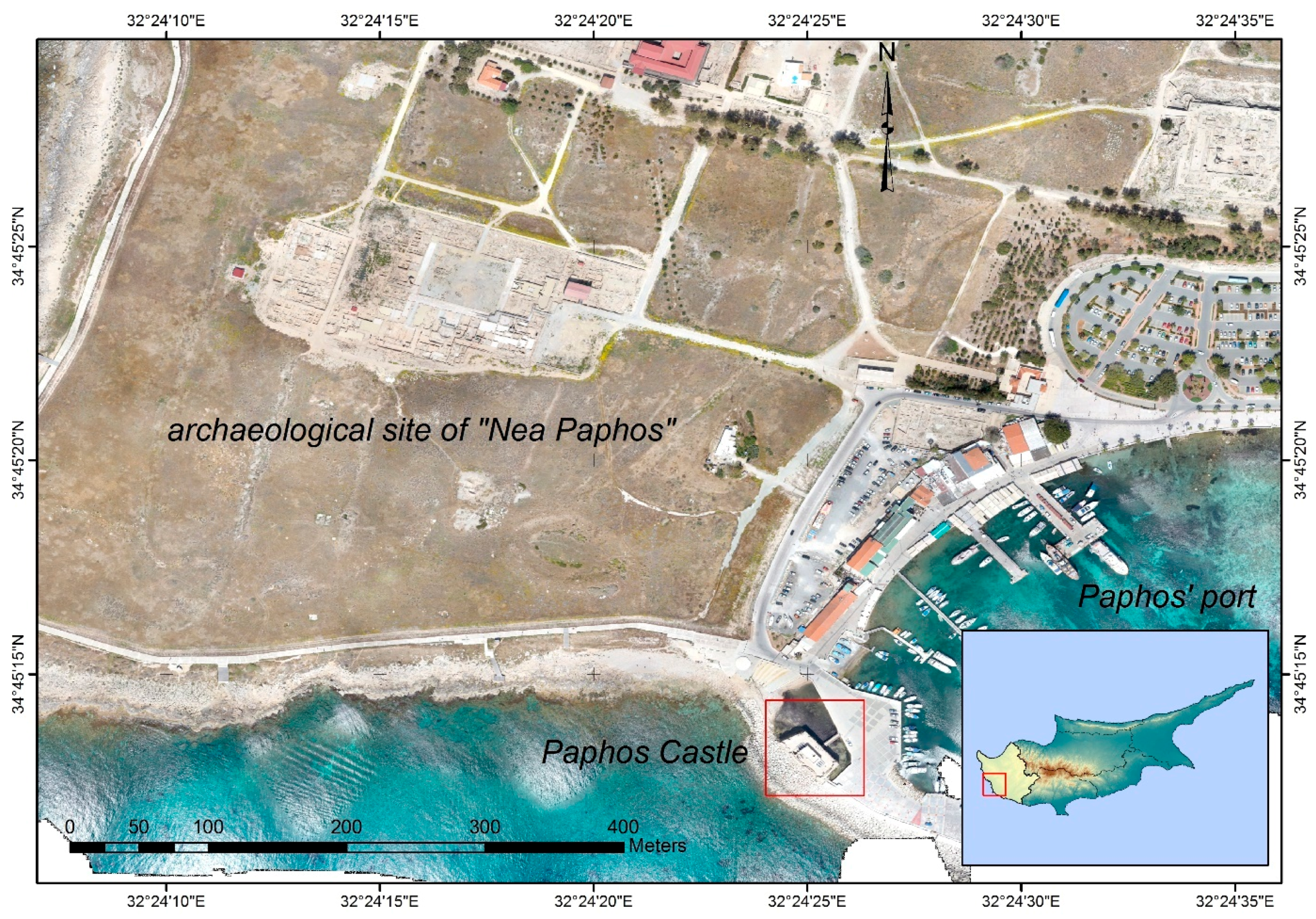
2. The Paphos Castle

2.1. History of the Monument

The case study selected for the present application concerns the monument known as Paphos Harbour Castle, located at the western site of the port of Kato Paphos, in western Cyprus (34°45.220’ N; 32°24.419’ E, WGS) (Figure 1). The castle in its present form is the result of various reconstructions over the years, reflecting part of the political and military ventures of the island’s history. Apart from the preservation of the monument’s historic phases, the reconstruction of the castle is a testament to the history of restoration followed on the island in more recent times.
The medieval castle of Paphos has been declared an Ancient Monument since 1935 (with the Department of Antiquities of Cyprus being responsible for its preservation and maintenance), and in 1980 was included together with the entire archaeological site of Paphos and other monuments of the area on the UNESCO World Heritage List.
The medieval fortress consists one of the two towers built in the mid-13th century to replace the fortress of Saranta Colones 600 m further to the north-east, destroyed by an earthquake in 1222 A.D. These two towers were connected through a defensive wall and entrusted with the task of controlling the entrance of the port, while at the same time protecting the city, which was under Lusignan rule at that time [17,18].
During the Frankish period, Cyprus suffered repeated raids from the Genoese and the Mamluks. According to the chronicler Leontios Machairas, in the 14th century, the Genoese occupied Paphos fortresses. In order to make the forts stonger, they lifted them up, and opened around ditches filled with sea water [19].
The Venetians (1474–1571 A.D.) focused on the development of Cyprus’ defensive system mainly in other regions of the island, with no important defensive works carried out in Paphos. According to the Venetian chronicler Marino Sanuto and other travellers of that time, two fortresses or castles (kastellia) are mentioned as being found at the entrance of Paphos port, preserved mainly for controlling the coast [20].
According to the German traveler Dietrich von Schachten, who visited Cyprus in July 1491, one of the two towers located near the sea was destroyed by an earthquake two months prior to his arrival in Cyprus. This earthquake took place on 24/25 April 1491 A.D., marking the beginning of the abandonment of the eastern port tower. The Czech traveller Oldrich Préfat (1546 A.D.) refers only to one square tower in Paphos port. It is highly probable that the damages that the eastern tower suffered, together with the absence of interest from the Venetians in Paphos fortress, led to its further destruction. In the mid-16th century, the Venetians destroyed these fortresses in order to avoid their use by enemies as fortifications against them [17].
In 1571 A.D., Cyprus was conquered by the Ottomans, who rebuilt the tower twenty-two years later, on the ancient seawall/breakwater and on the ruins of the Frankish fortress, which was strengthened in 1391 A.D. by King Iacovos I. A white marble slab (dimensions: 150 × 40 cm) above the entrance of the tower refers to its reconstruction in 1592 AD, by the Turkish commander of Cyprus Ahmet Pasha (1589–1593). The ground floor and basement of the fort were used by the Ottomans as a prison, while the central area of the upper floor was used as a mosque and rooms for the military garrison accommodation.
In 1878 A.D., with the British colonisation of the island, the fort was no linger used for defensive purposes, and was converted into a colonial government salt store.

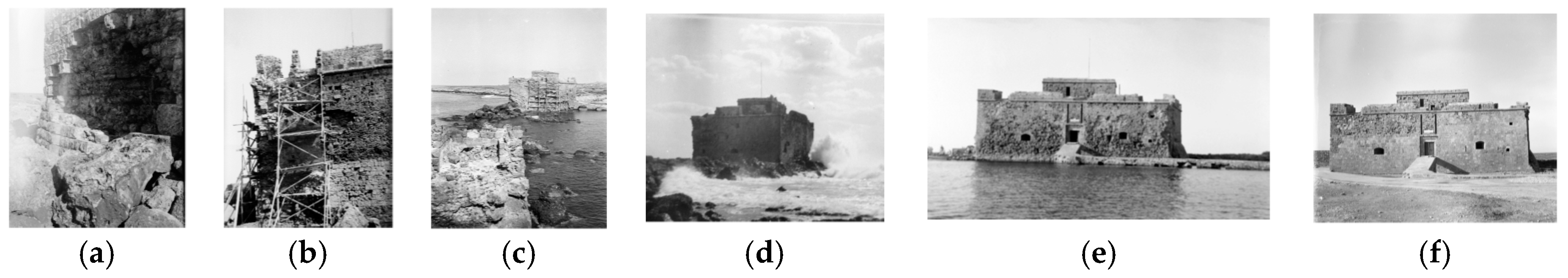
2.2. History of the Monument’s Conservation and Restoration Interventions

Regarding the modern history of the monument, its deterioration through the years was partially due to natural parameters of long-term weathering processes that led to its aesthetic degradation, but mainly due to violent natural and anthropogenic factors, such as the double earthquake of September 1953 and the 1974 bombardment of the castle.
The restoration and conservation of the monument by local authorities started when the Department of Antiquities of Cyprus was established in 1935 (Figure 2a–f). The various actions that took place towards its preservation are briefly described in the Annual Reports of the Department of Antiquities of Cyprus (ARDA). Some of the major restoration and/or conservation works accomplished are briefly described here:
During 1938–1939, the reinforcement of sections of the ancient breakwater on which the castle rests was carried out. These sections had to be further reinforced with concrete in 1949 after being eroded again by the sea (ARDA 1949).
The earthquake of 1953 provoked great cracks along the walls of the castle. The cracks in contact with rain water were initially filled as a temporary remedy (ARDA 1953). Later on, other actions were taken, such as the placement of a hidden reinforced concrete collar around the outer walls of the entrance lintel level (ARDA 1955). By 1956, all the damages provoked by the earthquake had been repaired (ARDA 1956), while injections for feeling cracks as well as the replacement of severely weathered building blocks were reported in the following years (ARDA 1960, ARDA 1961, ARDA 1966, ARDA 1967). Between 1968 and 1969, a breakwater was built in the southwest part of the castle to protect its intensively weathered foundations [21,22].
The castle went through intensive repairs after the 1974 bombarding (Karageorghis, 1974–1976). The replacement of corroded stones in the inside and outside of the castle, as well as the grouting and filling of cracks, was reported within the following years (Karageorghis, 1977–1984 (1975–1985); Karageorghis, 1986–1987 (1987–1988); Loulloupis, 1991 (1992); Christou, 1992 (1998); Christou 1993–1994; Hadjisavvas 1995–1996; Hadjisavvas 1998; Flourentzos 1999) [22,23,24].

3. Methodology

For the aims of this study, analytical methods were employed to identify the mineralogical and chemical composition of the monument’s construction materials, as well as for the identification of the main deterioration mechanisms taking place. The mineralogical study and understanding of the building blocks, joint mortars, and surface coating of the monument support the indication of the alterations occurring in these materials. The methodological approach was composed of three steps.
(a) In-situ visual investigation of the monument was carried out in order to assess the overall condition of the monument. During this macroscopic investigation, the major weathering indices were detected, photographed, and grouped. The characterisation of the decay was based on the international prototypes related to stone decay of architectural monuments of the ICOMOS International Scientific Committee for Stone (ISCS). The macroscopic observation of the monument was a significant step in determining the sampling spots to be later examined through the destructive analytical techniques.
(b) Destructive laboratory analytical techniques were employed to identify the type of stone and mortar used for the construction and/or previous restoration/conservation interventions to the monument. These techniques were further exploited for the identification of the deterioration factors to which the monument had been subjected. Selective sampling of the construction material (both natural-stone and artificial-mortar) from the monument’s external walls was obtained for the analytical investigation. Summarising the characteristics of each sample, a specific database was created, which included information such as the exact point of the sample extraction, date of sampling, weather conditions, sample description, photographic documentation, dimensions, etc. Stereoscopic examination of small fragments from the studied materials as well as the study of polished thin sections under microscope were used to study the basic characteristic attributes of the material under investigation, such as colour, porosity, grain size, minerals, alterations, and cement material. All samples were examined by X-ray diffraction (XRD), which allowed the mineralogical identification of the stones employed. Patterns of powdered samples with random orientation were obtained using a Philips (PW1710) diffractometer with Ni-filtered CuKα radiation. The counting statistics of the XRD study were: step size 0.05° 2θ, starting angle 3°, ending angle: 63° and scan speed: 0.02° 2θ/s. A quantitative estimation of the abundance of the phases was derived from the XRD data, using the intensity of certain reflections and external standard mixtures of minerals scanning under the same conditions [25]. The morphology and chemical composition of the studied samples, as well as their deterioration products, were determined by scanning electron microscopy (SEM) using a 20 kV JEOL 840A SEM equipped with an OXFORD INCA 300 energy-dispersive spectrometer (EDS) analyser.
(c) Digital photogrammetric documentation of the monument’s external wall surfaces was accomplished with the use of a high-resolution NIKON D7100 photographic camera. The images had a dimension of 6000 × 4000 pixels while the focal length (f) of the camera was set to 35 mm. The CMOS sensor of NIKON D7100 has a dynamic radiometric capacity of 14 bits while a red, green, blue band (RGB) colour filter array is used.
The rectified images of the monument’s external facades were generated using photogrammetric techniques. The high quality of the produced rectified images is of extreme importance in order to permit the most correct possible definition and detection of characteristics and alterations present on the monument to be reported. A reflector-less total station (±3′′ angle accuracy and 3 mm + 1.5 ppm distance error) was used for the acquisition of the check points and to create a local control network point around the monument. Check points were taken from all four external surfaces of the monument, capturing its edges, characteristic features of the surface, and other scattered points, in an effort to cover the whole surface. Rectification of the images—for each façade separately—according the check points, followed based on an affine transformation. Affine transformation was applied due to the almost flat surface of the facades, compared to other well-known photogrammetric transformations (e.g., structure from motion (SfM)). The rectification was achieved within an error of a few centimetres (TRMS < 2 cm), which was considered reasonable for the aims of the study (i.e., macroscopic investigation of the monument).
(d) Digital image processing (DIP). The rectified images were then processed to map the different stone deterioration patterns. This was accomplished through the environment for visualizing images (ENVI of the Harris Geospatial Solutions) software. ENVI is suitable for efficient information extraction from digital imagery. Three different types of image processing were applied for the Paphos Harbour Castle case study: (a) image thresholding, (b) image classification, and (c) an anomaly detection algorithm.
Thresholding is a simple and fast way to group pixels in a region that shares the same range of intensity. Therefore, thresholds were initially applied to the multiband image (RGB) in order to group pixels with the same intensity in the specific wavelengths (i.e., blue–green–red part of the spectrum).
Further to the image segmentation (i.e., thresholding), various histogram enhancement techniques can be also applied to improve the interpretation of the final image. For the specific case study, minimum–maximum and standard deviation histogram enhancements were applied.
In addition, pixel-based classification algorithms were also applied to the rectified images of the monument’s external facades. Initially, a supervised classification strategy was followed by selecting pixels of interest (i.e., training data) from the image. The supervised learning algorithm analyzes the training data, and then applies the learning algorithm to the rest of the image. Specifically, the support vector machine (SVM) classifier was applied. SVM is a machine-supervised learning model which analyzes the image data used for classification and then groups the rest of the pixels of the image in a n-dimension hyperplane.
In contrast, unsupervised classification algorithms do not require any training sample, since it groups pixels into “clusters” based on their properties (i.e., the digital numbers of the pixels). The iterative self-organizing data analysis technique (ISODATA) classification algorithm was evaluated in our case study. The specific algorithm initially calculates the class means of the 3D data space (i.e., blue–green–red) and then iteratively creates clusters based on minimum distance techniques. Each iteration recalculates the cluster means, and then reclassifies the pixels with respect to the new means.
Finally, RX anomaly detection was applied. This automatic anomaly detection algorithm uses the Reed–Xiaoli detector (RXD) algorithm to extract targets that are spectrally distinct from the image background, since it detects the spectral or color differences between a region and its neighboring pixels [26].

4. Results and Discussion

According to [27], the degradation of historic monuments located in the area of the Mediterranean coastline is mainly due to the action of marine aerosols, as well as to industrial and urban pollution. Regarding the harbour castle of Nea Paphos, the most substantial impact in relation to the deterioration of the monuments’ constructive materials is its direct exposure to the atmospheric conditions and more specifically its location in great proximity to the sea. The potential impact of the sudden and intense urbanization of the city after 1974 [28,29], needs to be investigated also. This combination accelerated the deterioration processes, while at the same time rendering them more intense and complicated. In addition, the fact that the monument is built on an ancient breakwater barrier and thus is surrounded by sea water, favours multiple alterations to its building compounds.

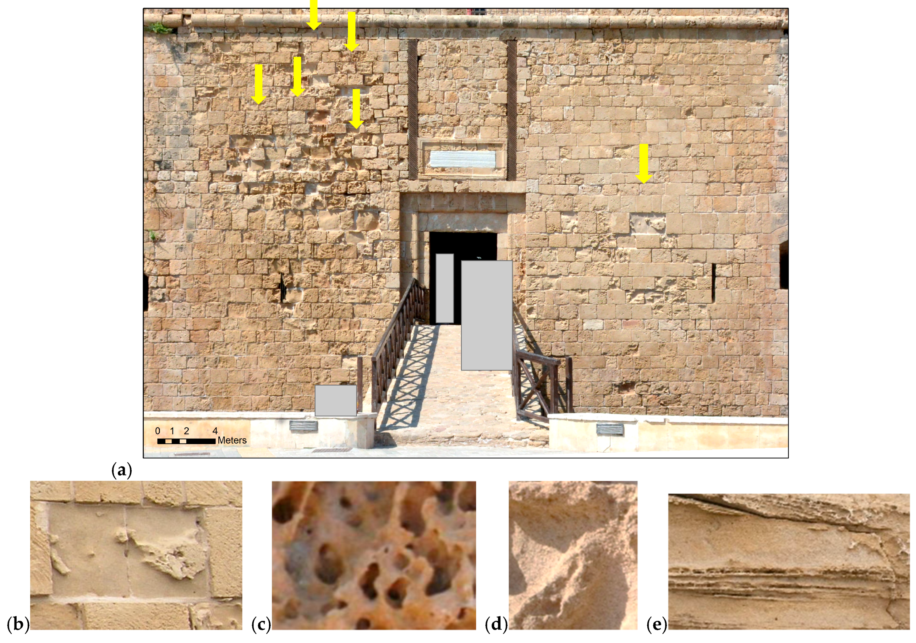
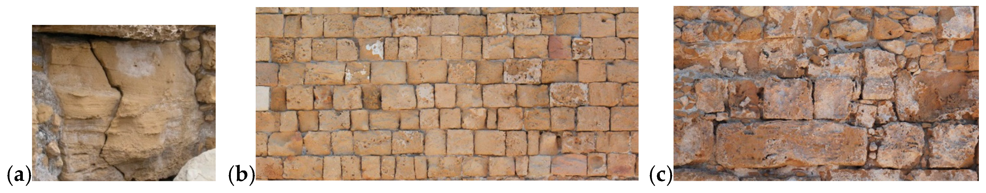
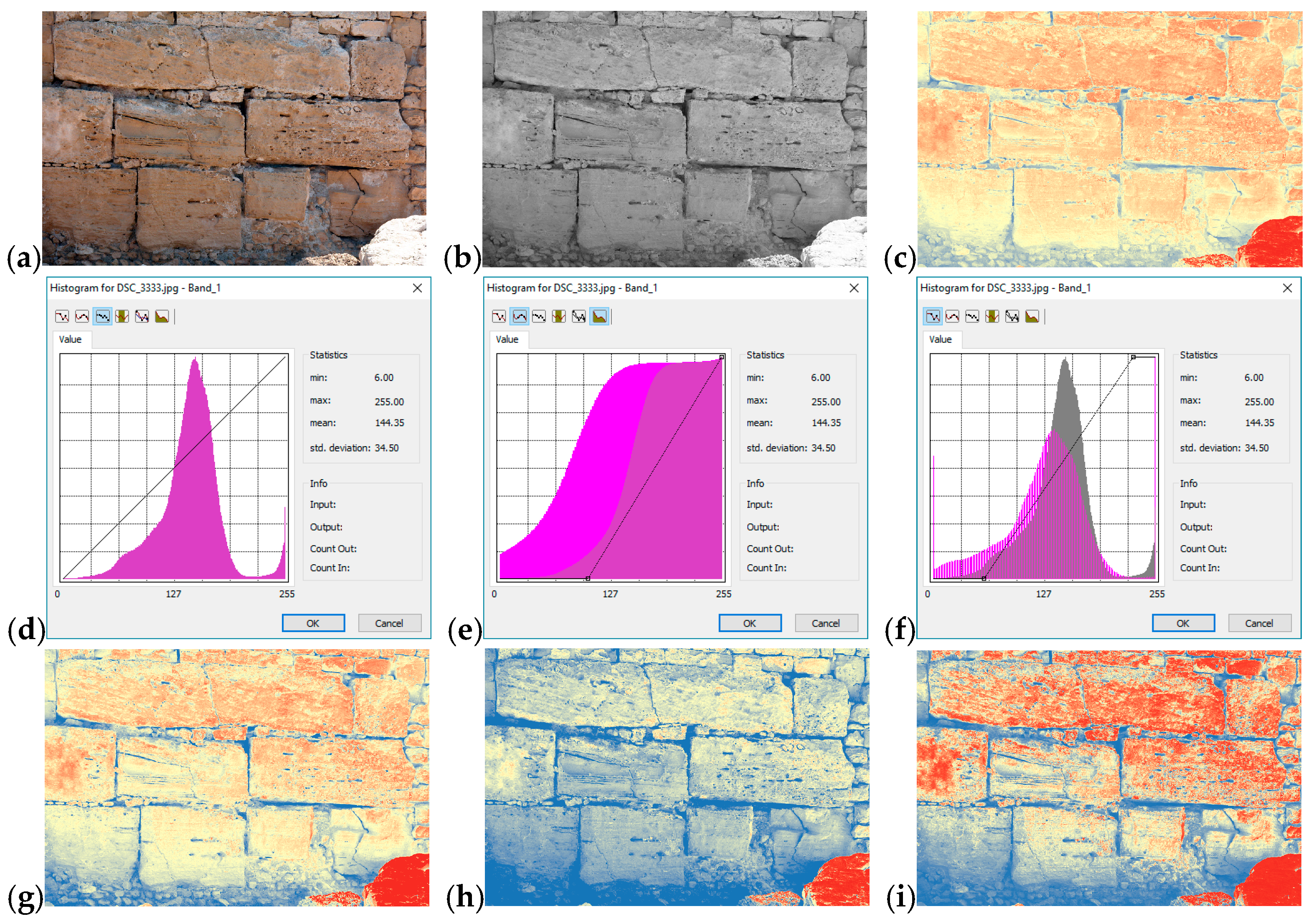
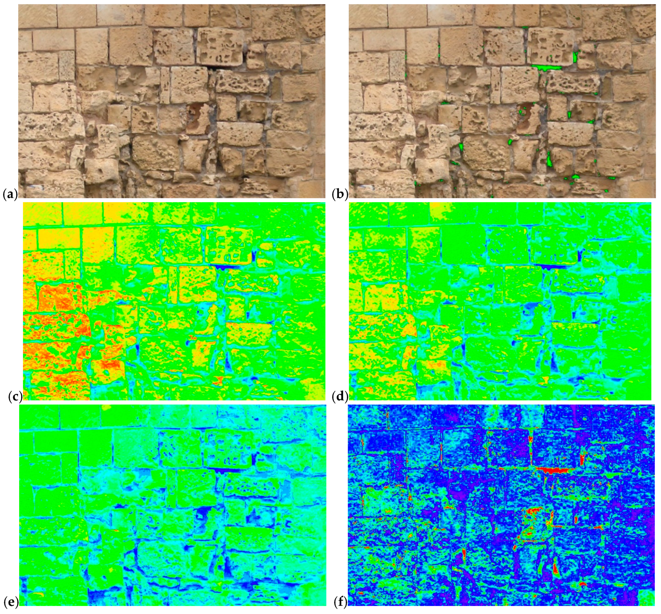
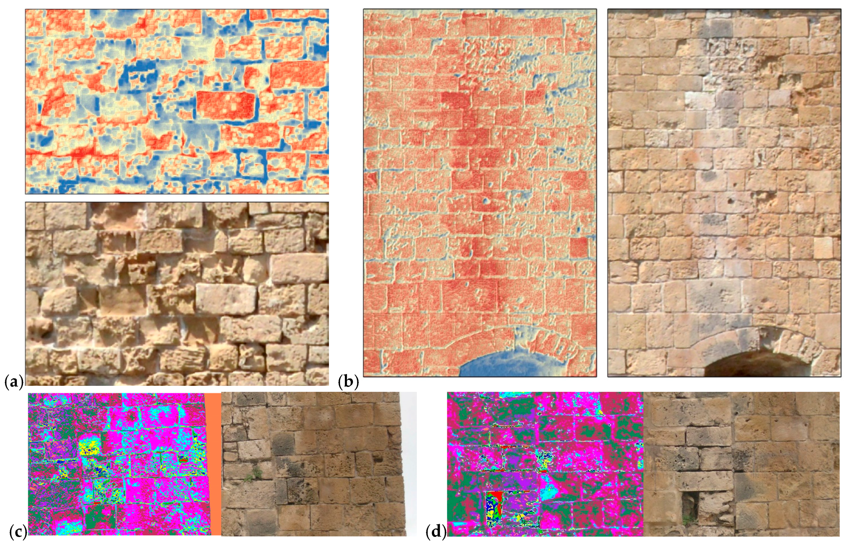
4.1. Stone Deterioration Patterns of ICOMOS-ISCS Based on Visual Investigation

Visual observation identified a series of discontinuities observed on the monument’s external wall parapets. Those were grouped together, based on international standards of the ICOMOS-ISCS (2008) illustrated glossary of stone deterioration patterns [30]. More specifically, patterns of detachment, crack and fragmentation, features induced by material loss, discoloration and deposit, and biological colonization have been reported.
The prevalent deterioration patterns observed on the main (north) façade of the monument (Figure 3a) are features induced by material loss, such as alveolization and coving (Figure 3b–e). Discoloration occurs on two distinctive moist areas on the monument’s façade, as a result of a concentrated discharge of rain water (Figure 9b). Apart from the north façade, features induced by material loss were also detected on the western wall of the monument and on a smaller scale on the southern and eastern walls, and the resultant patterns are related to alveolization in the form of coving; erosion (differential and/or loss of components); missing parts (creation of gaps), and perforations.
Cracks and deformation were not found on the monuments’ external walls, apart from local fracturing developed in the cross-section of specific building stones, which was an isolated case for the monument and is probably due to local overloading (Figure 4a).
The detachment group presents few cases of fragmentation patterns and decays of the delamination/exfoliation pattern due to salt crystallization. Many stone blocks present perimetrical exfoliation, which leads to the pulverization of part of the construction blocks and the detachment of stone fragments. Also, loose material from the joint mortars was extended in most of the south wall (Figure 4b). Discolouration induced by efflorescence patterns and salt crusts was observed to be more intense on the southern wall (Figure 4c).
Biological colonization was limited and consisted mainly of the plants observed growing on the external south wall of the monument (Figure 4d). The roots of some plants can cause significant stress problems to the stones on and around which they develop, as they form places with high humidity.
The overall result of the in situ investigation indicated the major weathering alterations to be attributed to the presence of salt and the proximity of the monument to the sea, and as being mainly a result of alveolization, thus creating the effect of coving, differential erosion, rounding, roughening, and other effects. The various forms of alveolization were observed both in initial and advanced stages in which the cells were combined together and formed large cavities. This corrosion results from salt crystallization inside the blocks, as shown in all the analyses performed, which increases the internal stresses in the rock, causing a loss of consistency. The corrosion is facilitated by the high porosity of the specific building material, as verified during the macroscopic and microscopic observation. The high porosity favors the entry of water (rich in salts from the sea) in the rock and the formation of salt crystals. Furthermore, the lack of rigid structure in the rock renders it more vulnerable to withstand the tension created by the salt crystallization. Also, the case of cellular corrosion that develops on surfaces following the primary sedimentary layering of the stone has been observed.

4.2. Analytical Techniques

The laboratory analysis resulted in a series of information for each sample (Figure 5). Stereoscopic observation permitted the colour and composition characterisation (Figure 5b), while the results of the microscopic examination as shown in Figure 5c,d for sample No. 1 revealed a variety of information related to the texture of the rock, the mineralogical composition, the high porosity, the presence of cement material, their petrographic classification, and other information. Also, in Figure 5e, a representative XRD pattern is provided.
The overall results from the analytical techniques, revealed a high accumulation of gypsum and halite in most of the tested samples, and demonstrated the causes of the deterioration mechanisms manifesting on the monument’s construction stones. According to [31], the formation of gypsum crystals and halite inside the porous building stones destroys the structure of the rock due to the development of internal stresses, when the available space in the pores is limited. The high amounts of halite are connected to the location of the monument in a coastal environment, as well as to the use of the monument as a salt storehouse for almost 57 years. The mineralogical composition of a series of samples (Figure 6) referring to the eastern (Samples No.: S23–S26) and the western (Samples No.: S1–S3, S6–S9, S16–S18 and S27) external façades of the monument are shown in Table 1.

4.3. Non-Destructive Techniques

Digital image processing was applied to the rectified images of the monument’s external surfaces. Through this process, the earlier identification of the various stone deterioration patterns was visualized, initially by image segmentation. Thresholding is the simplest method of image segmentation since the algorithm divides an image into two (or more) classes of pixels. For the example under examination here, natural breaks of the rectified image’s histogram were used in all three bands (i.e., blue–green–red bands). As shown in Figure 7, the individual spectral bands of the RGB image (Figure 7a) can be visualized either in grayscale or in a colourmap range (Figure 7b,c, respectively). Then histogram enhancement techniques such as minimum–maximum and standard deviation were applied (Figure 7d–f) to improve the interpretation of the image (Figure 7g–i).
Figure 8 shows the results after adding specific threshold values, which were defined based on the visual inspection (Figure 8c–e). Indications with the same colour define the same optical properties (of the specific wavelength) for the external material of the façade. This can allow a fast and first documentation of the external façade of the monument, taking into consideration that other parameters such as showdown can also affect the outcome. The specific range of the threshold can also be isolated and visualized, as shown in Figure 8b, thus identifying the mortar loss from the joints.
Further image analysis was also applied using the RXD anomaly detection algorithm. This method enabled the mapping of the various alterations in the whole external surface, creating the possibility to quantify the extension of each one in terms of percentage and thus in terms of square meters. The results after the application of the RXD algorithm are shown in Figure 8f. Areas highlighted in blue are regions that are considered smooth, referring to the healthy masonry blocks. In contrast, areas that are highlighted in red are areas that highly possibly suffer from stone decay.
In addition to thresholding and the RXD algorithm, a supervised classification (SVM) was applied using specific areas of the image as training samples. Image classifiers offered the possibility to detect and visualize various types of anomalies on the built wall surface and to understand the alteration level.
For instance, image processing applied to the western part of the main façade of the castle (Figure 9a,b) shows in blue the potential material loss from the joints of the masonry walls. Even though such interpretation can also be performed by manual digitization of the raw rectified image, the DIP allows automatic extrapolation of the overall results in a quick way, as well as the performance of similar quantitative analysis applied to archive images and consequent tracking of the deterioration evolution in time, with regards to monuments not subjected to maintenance. Therefore, supervised techniques can detect deterioration patterns mainly based on the shadows caused by alterations on the stones. Moreover, the classified areas that are selected as “hot spots” can be vectorised and thereafter quantify the overall material loss areas.
Figure 9c,d indicates the state of preservation of an area on the eastern part of the main façade of the castle, following an unsupervised (ISODATA) classification strategy. All types of elaboration applied show the discontinuity of this part of the wall, while the variations on the stone relief due to the different intensity provoked by the decay of each stone and the depth of the deterioration are more visible.

5. Conclusions

In this paper, the synergistic effort to detect, quantify, and visualize the presence of the deterioration patterns on a monument’s surface was presented. This effort was achieved by combining both destructive material analysis and non-destructive DIP analysis for the digital mapping of the alterations. This type of multidisciplinary approach was to the authors’ knowledge applied for the first time in Cyprus.
The results of the visual investigation and recording of the various deterioration patterns were successfully correlated to the analytical methods used and also detected through the non-destructive DIP analysis. The supervised classification of the results of the images treated by unsupervised techniques demonstrated the potential of providing results that can be verified by laboratory analysis and the DIP procedure.
The visualization of these patterns was represented through colour variation intensity, and the results comprise indices for those parts of the monument requiring conservation interventions. Moreover, based on the achieved results recommendations related to the conservation of the monument could consequently be drawn. These were more concrete in terms of the quantification of the works and better management planning, since, it is possible to quantify the various conservation interventions (such as the replacement of stones).

Acknowledgments

Thanks are due to the Department of Antiquities of Cyprus for supporting the investigation of the monument, as well as for the access to the Department’s photographic archive. The present communication is under the “ATHENA” project H2020-TWINN2015 of European Commission. This project has received funding from the European Union’s Horizon 2020 research and innovation programme under grant agreement No 691936.

Author Contributions

V.L. and A.A. conceived and wrote the paper, and performed the DIP; M.I., N.K. and E.C. conceived and performed the sampling and destructive analyses experiments. All authors read, revised and approved the final manuscript.

Conflicts of Interest

The authors declare no conflict of interest.

References

  1. International Council on Monuments and Sites (ICOMOS). Heritage at Risk: ICOMOS World Report 2008/2010 on Monuments and Sites in Danger; Machat, C., Petzet, M., Ziesemer, J., Eds.; International Council on Monuments and Sites: Paris, France, 2014. [Google Scholar]
  2. United Nations Educational, Scientific and Cultural Organization (UNESCO). Policy Document on the Impacts of Climate Change on World Heritage Properties, UNESCO World Heritage Centre Publications on Climate Change. 2008. Available online: www.whc.unesco.org/document/10046 (accessed on 1 November 2017).
  3. Žarnić, R.; Rajčić, V.; Skordaki, N. A contribution to the built heritage environmental impact assessment, ISPRS Annals of the Photogrammetry, Remote Sensing and Spatial Information Sciences. In Proceedings of the 25th International CIPA Symposium, Taipei, Taiwan, 31 August–4 September 2015; pp. 389–394. [Google Scholar]
  4. Douglas-Jones, R.; Hughes, J.; Jones, S.; Yarrow, T. Science, value and material decay in the conservation of historic environments. J. Cult. Herit. 2016, 21, 823–833. [Google Scholar] [CrossRef] [Green Version]
  5. Ganje, F.P.; Hezbkhah, E.; Maashkar, B. Evaluation of the Effects of Climate Change in Destruction Procedure on Iran’s Historic Buildings. Int. J. Soc. Behav. Educ. Econ. Bus. Ind. Eng. 2011, 5, 1718–1720. [Google Scholar]
  6. Sánchez, J.; Quirós, E. Semiautomatic detection and classification of materials in historic buildings with low-cost photogrammetric equipment. J. Cult. Herit. 2017. [Google Scholar] [CrossRef]
  7. Chrysostomou, C.Z.; Hadjimitsis, D.G.; Agapiou, A.; Lysandrou, V.; Themistocleous, K.; Demetriadou, C. Application of non-destructive techniques in assessing the quality of stone building materials in cultural heritage structures in Cyprus: Use of ultrasonic and 3D laser scanning integrated approach for diagnostic tests. In Proceedings of the 3rd International Euro-Mediterranean Conference, Limassol, Cyprus, 8–13 November 2010; Ioannides, M., Ed.; Archaeolingua: Budaapest, Hungary, 2010; pp. 269–274. [Google Scholar]
  8. Bartz, W.; Rogoz, J.; Rogal, R.; Cupa, A.; Szroeder, P. Characterization of historical lime plasters by combinied non-destructive tests: The case of the sgraffito in Bożnów (SW Poland). Constr. Build. Mater. 2012, 30, 439–446. [Google Scholar] [CrossRef]
  9. Moropoulou, A.; Labropoulos, K.C.; Delegou, E.T.; Karoglou, M.; Bakolas, A. Non-destructive techniques as a tool for the protection of built cultural heritage. Constr. Build. Mater. 2013, 48, 1222–1239. [Google Scholar] [CrossRef]
  10. Tsilimantou, E.; Delegou, E.; Ioannidis, C.; Moropoulou, A. Geoinformation techniques for the 3D visualisation of historic buildings and representation of a building’s pathology. In Proceedings of the 4th International Conference on Remote Sensing and Geoinformation of the Environment, Paphos, Cyprus, 4–8 April 2016; Themistocleous, K., Hadjimitsis, D.G., Michaelides, S., Papadavid, G., Eds.; SPIE: Bellingham, WA, USA, 2016. [Google Scholar]
  11. Cossu, R.; Chiappini, L. A color image segmentation method as used in the study of ancient monument decay. J. Cult. Herit. 2004, 5, 385–391. [Google Scholar] [CrossRef]
  12. Vázquez, A.M.; Galán, E.; Guerrero, A.M.; Ortiz, P. Digital image processing of weathered stone caused by efflorescences: A tool for mapping and evaluation of stone decay. Constr. Build. Mater. 2011, 25, 1603–1611. [Google Scholar] [CrossRef]
  13. Arias, P.; Herráez, J.; Lorenzo, H.; Ordóñez, C. Control of structural problems in cultural heritage monuments using close-range photogrammetry and computer methods. Comput. Struct. 2005, 83, 1754–1766. [Google Scholar] [CrossRef]
  14. Kyriakides, N.; Lysandrou, V.; Agapiou, A.; Illampas, R.; Charalambous, E. Correlating damage condition with historical seismic activity in underground sepulchral monuments of Cyprus. J. Archaeol. Sci. Rep. 2017, 14, 734–741. [Google Scholar] [CrossRef]
  15. Chen, F.L.; Wu, Y.; Zhang, Y.; Parcharidis, I.; Ma, P.; Xiao, R.; Xu, J.; Zhou, W.; Tang, P.; Foumelis, M. Surface motion and structural instability monitoring of Ming Dynasty City Walls by two-step Tomo-PSInSAR approach in Nanjing City, China. Remote Sens. 2017, 9, 371. [Google Scholar] [CrossRef]
  16. Chen, F.L.; Guo, H.; Ma, P.; Lin, H.; Wang, C.; Ishwaran, N.; Hang, P. Radar interferometry offers new insights into threats to the Angkor site. Sci. Adv. 2017, 3, e1601284. [Google Scholar] [CrossRef] [PubMed]
  17. Aristeidou, A.X. Το φρούριο της Πάφου (Paphos Fortress); Cyprus Research Centre: Nicosia, Cyprus, 1994. [Google Scholar]
  18. Maier, F.G.; Karageorghis, V. Paphos: History and Archaeology; A. G. Leventis Foundation: Nicosia, Cyprus, 1984. [Google Scholar]
  19. Machairas, L. Χρονικό Κύπρου (Cyprus Chronicle), ed. Satha K., Medieval Library Β´ Venice 528 1873 (Reprint Paris, 1877); Φιλόκυπρος: Nicosia, Cyprus, 1982. [Google Scholar]
  20. Aristeidou, A.X. Aνέκδοτα έγγραφα της Κυπριακής Ιστορίας από το Aρχείο της Βενετίας (Unpublished Documents of Cyprus History from the Archive of Venice); Cyprus Research Centre: Nicosia, Cyprus, 1990; Volume A’, pp. 1474–1508. [Google Scholar]
  21. Karageorghis, V. (Ed.) Annual Report of the Department of Antiquities for the Years 1974–1976; Ministry of Communications and Works: Nicosia, Cyprus, 1975–1977.
  22. Christou, D. (Ed.) Annual Report of the Department of Antiquities for the Years 1993 and 1994; Ministry of Communications and Works: Nicosia, Cyprus, 1998 and 2003.
  23. Hadjisavvas, S. (Ed.) Annual Report of the Department of Antiquities for the Years 1995–1998; Ministry of Communications and Works: Nicosia, Cyprus, 2003.
  24. Flourentzos, P. (Ed.) Annual Report of the Department of Antiquities for the Year 1999; Ministry of Communications and Works: Nicosia, Cyprus, 2006.
  25. Kantiranis, N.; Stergiou, A.; Filippidis, A.; Drakoulis, A. Calculation of the percentage of amorphous material using PXRD patterns. Bull. Geol. Soc. Greece 2004, 36, 446–453. [Google Scholar]
  26. Reed, I.S.; Yu, X. Adaptive multiple-band CFAR detection of an optical pattern with unknown spectral distribution. IEEE Trans. Acoust. Speech Signal Process. 1990, 38, 1760–1770. [Google Scholar] [CrossRef]
  27. Galan, E.; Aires Barros, L.; Christaras, B.; Kassoli-Fournaraki, A.; Fitzner, B.; Zezza, F. Representative stones from the sanctuary of Demeter in Eleusis (Greece), Sta. Marija ta Cwerra of Siggiewi (Malta) and Bari (Italy) and Cadiz (Spain) cathedrals. Petrographic characteristics, physical properties and alteration products. In Origin, Mechanisms and Effects of Salts on Degradation of Monuments in Marine and Continental Environments, Proceedings of E.C. Research Workshop, Bari, Italy, 25–27 March 1996; European Commission: Brussels, Belgium, 1997; pp. 77–85. [Google Scholar]
  28. Agapiou, A.; Alexakis, D.D.; Lysandrou, V.; Sarris, A.; Cuca, B.; Themistocleous, K.; Hadjimitsis, D.G. Impact of Urban Sprawl to cultural heritage monuments: The case study of Paphos area in Cyprus. J. Cult. Herit. 2015, 16, 671–680. [Google Scholar] [CrossRef]
  29. Agapiou, A.; Lysandrou, V.; Themistocleous, K.; Hadjimitsis, D.G. Risk assessment of Cultural Heritage Sites Clusters Using Satellite Imagery and GIS: The case study of Paphos District, Cyprus. J. Nat. Hazards 2016, 83, 5–20. [Google Scholar] [CrossRef]
  30. Verges-Belmin, V. ICOMOS—International Scientific Committee for Stone (ISCS): Illustrated Glossary on Stone Deterioration Patterns; Monuments and Sites XV; ICOMOS International Scientific Committee for Stone (ISCS): Champigny/Marne, France, 2008. [Google Scholar]
  31. Steiger, M.; Charola, E.A.; Sterflinger, K. Weathering and deterioration. In Stone in Architecture; Siegesmund, S., Snethlage, R., Eds.; Springer: Berlin/Heidelberg, Germany, 2011. [Google Scholar]
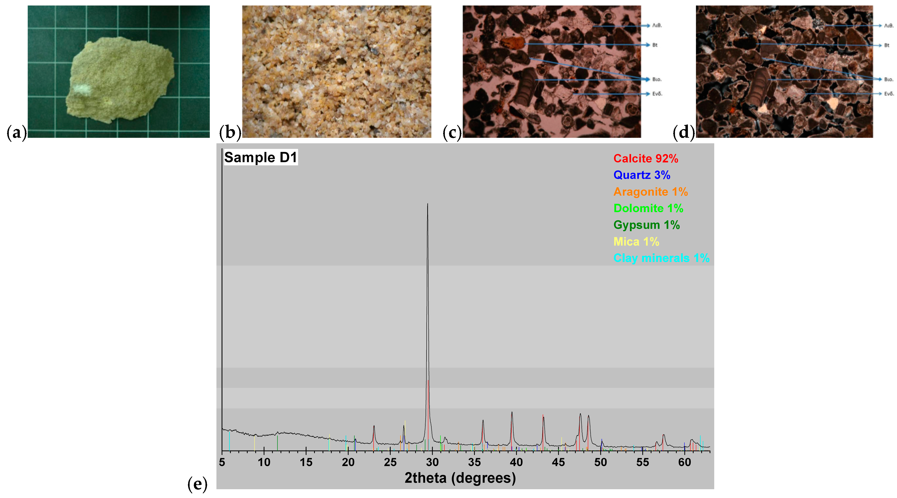
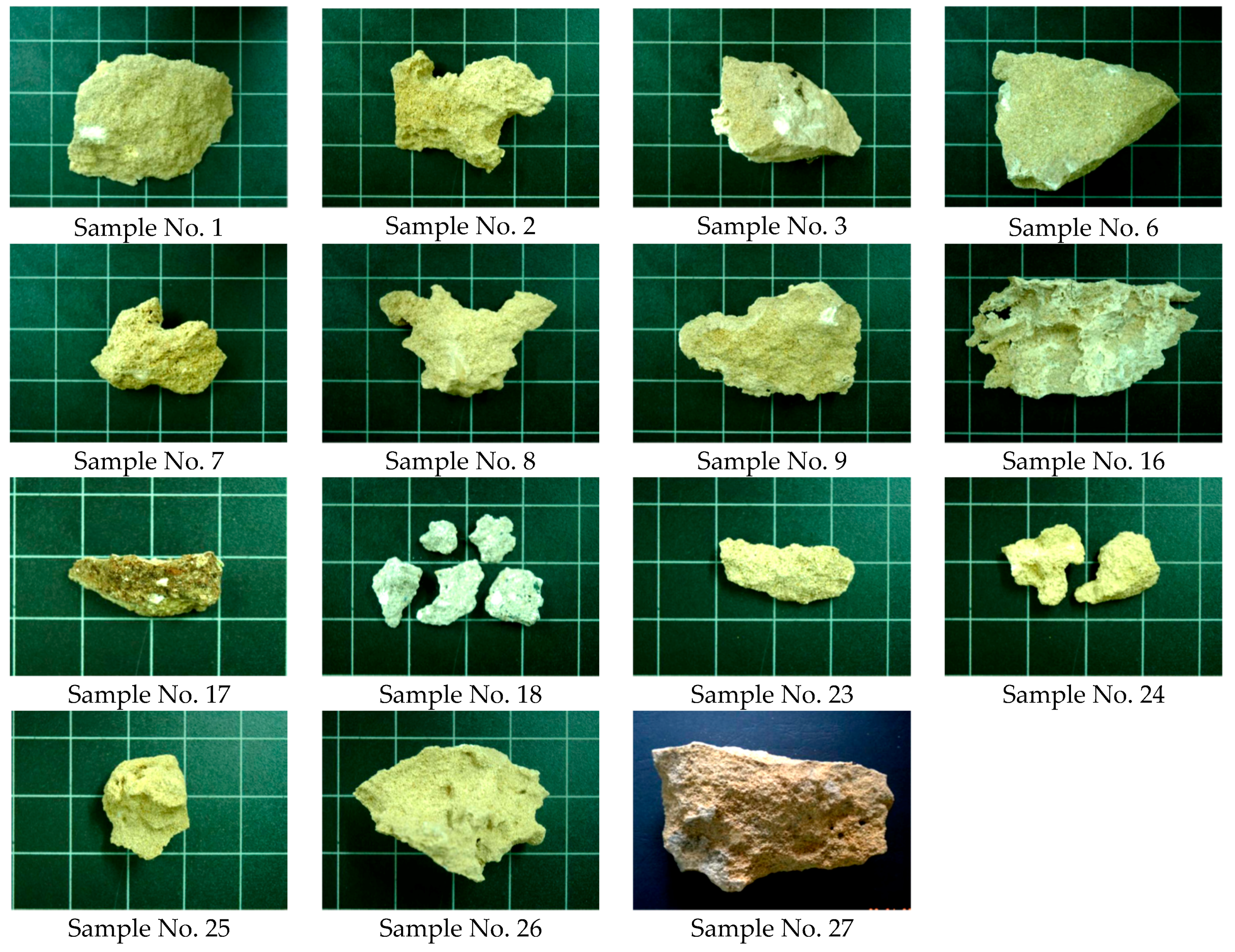
Figure 1. Paphos castle located in the western part of Cyprus (Paphos District), south of the archaeological site of “Nea Paphos”. Both sites are listed as UNESCO World Heritage.
Heritage 01 00001 g001
Figure 2. (from left to right): (a) Extended destruction of the external masonry wall (Archive of the Department of Antiquities of Cyprus, 1936); (b) Restoration works on the external north wall (Archive of the Department of Antiquities of Cyprus, 1939); (c) Conservation works on the south wall masonry (Archive of the Department of Antiquities of Cyprus, 1938); (d) The absence of water break infrastructure led to monument exposure, especially its western side (Archive of the Department of Antiquities of Cyprus, 1939); (e) East façade (Archive of the Department of Antiquities of Cyprus, 1939); (f) East façade (Archive of the Department of Antiquities of Cyprus, 1964).
Heritage 01 00001 g002
Figure 3. Part of the rectified north (main) façade of the monument (a). Some of the features induced by material loss (be) are evidenced with yellow arrows in (a).
Heritage 01 00001 g003
Figure 4. Individual fissures, clearly visible to the naked eye (a); Loss of mortar joints between the masonry blocks (b); Surface discoloration in the form of salt efflorescence pattern (c).
Heritage 01 00001 g004
Figure 5. Results from sample no. 1 (from left to right) (a) Macroscopic observation (b) Stereoscopic observation (max. image enlargement 11 mm) (c) Microscopic observation (Ν//, max enlargement 3 mm) (d) Microscopic observation (Ν^, max enlargement 3 mm) (e) X-ray diffractometry of sample D1.
Heritage 01 00001 g005
Figure 6. Photographs for Samples 1–27 (refer to Table 1).
Heritage 01 00001 g006
Figure 7. (a) RGB initial rectified image; (b) greyscale colourmap of the blue band (Band 1); (c) colourmap of blue band; (d) initial histogram of the blue band with no histogram enhancement; (e) min–max threshold (min: 100 and max: 250) histogram enhancement applied for the blue band; standard deviation histogram enhancement applied for the blue band; (gi) colourmap of the blue band after the application of (df) respectively.
Heritage 01 00001 g007
Figure 8. State of preservation of the main (north) façade of the castle using DIP techniques: (a) image; (b) adding threshold values in the image; (c) colour scale to the blue band; (d) colour scale to the green band; (e) colour scale to the blue band; and (f) RXD anomaly detection.
Heritage 01 00001 g008
Figure 9. State of preservation of the main façade of the castle using supervised and unsupervised techniques. (a) Eastern part of the entrance; (b) western part of the entrance; (cd) detail from the central part of the castle’s north façade.
Heritage 01 00001 g009
Table 1. Mineralogical composition (wt. %) of the samples studied by X-ray diffraction.
Sample No.FacadeCQGyHaArDoPlClMGoNotes
S1West933--11-11-Building block
S2West872371-----Building block
S3West945--1-----Building block
S6West883-6--1--2Building block
S7West691228-----Building block
S8West7295131-----Building block
S9West95311-----Building block
S16West834634-----Plastering
S17West35534511--1--Joint mortar
S18West5910-292-----Joint mortar
S23East953-2------Building block
S24East932-4--1---Building block
S25East875-8------Building block
S26East77589-1----Building block
S27West6823252-----Building block
C: Calcite, Q: Quartz, Gy: Gypsum, Ha: Halite, Ar: Aragonite, Do: Dolomite, Pl: Plagioclase, Cl: Clay minerals, M: Micas, Go: Goethite.

