Hydraulic Chiefdoms in the Eastern Andean Highlands of Colombia

The Foundation for Americas Research Inc., Winter Springs, FL 32719-5553, USA
Heritage 2018, 1(1), 100-121; https://0-doi-org.brum.beds.ac.uk/10.3390/heritage1010008
Submission received: 16 May 2018
/
Revised: 9 July 2018
/
Accepted: 9 July 2018
/
Published: 11 July 2018
Abstract
:The natural and cultural heritage of the Valley of Leiva in the Eastern Colombian Andes is closely tied to the Colonial town of Villa de Leyva. The popular tourist destination with rapid economic development and agricultural expansion contrasts sharply with an environment of limited water resources and landscape erosion. The recent discovery of Prehispanic hydraulic systems underscore ancient responses to water shortages conditioned by climate change. In an environment where effective rainfall and erosion are problematic, irrigation was vital to human settlement in this semi-arid highland valley. A chiefly elite responded to unpredictable precipitation by engineering a hydraulic landscape sanctioned by religious cosmology and the monolithic observatory at El Infiernito, the Stonehenge of Colombia. Early Colonial water works, however, transformed Villa de Leyva into a wheat breadbasket, though climatic downturns and poor management strategies contributed to an early 17th century crash in wheat production. Today, housing construction, intensive agriculture, and environmental instability combine to recreate conditions for acute water shortages. The heritage of a relatively dry valley with a long history of hydraulic chiefdoms, of which modern planners seem unaware, raises concerns for conservation and vulnerability to climate extremes and the need for understanding the prehistoric context and the magnitude of water availability today. This paper examines human ecodynamic factors related to the legacy of Muisca chiefdoms in the Leiva Valley and relevant issues of heritage in an Andean region undergoing rapid socio-economic change.
1. Introduction
In the Valley of Leiva of the Eastern Andes of Colombia, natural and cultural heritage is integrally tied to the Colonial town of Villa de Leyva. A popular tourist destination and place where housing development is growing by leaps and bounds, the valley is also undergoing intensive agricultural expansion. These factors compound pressures on already limited water resources and serve to highlight recent research into the discovery of Prehispanic hydraulic systems; ancient responses to water shortages conditioned by rapid climate change. In an environment where effective rainfall is often insufficient or inconveniently timed for farming and alluvial landscapes subject to intense erosion caused by periodic drought and flooding, irrigation was and still is vital to human settlement in the semi-arid portions of this highland valley. Chiefly elites tried to mitigate the effects of limited water supplies by engineering a hydraulic landscape sanctioned by religious cosmology embodied in the central stone monuments of the monolithic observatory at El Infiernito, the Stonehenge of Colombia. Understanding the prehistoric context and magnitude of factors conditioning unpredictable water availability is vital to modern planners to achieve sustainable economic development under challenging environmental constraints.
In Early Colonial times, hydraulic systems transformed Villa de Leyva and its environs into a wheat breadbasket for the Viceroyalty of Nueva Grenada, while traditional maize production remained relatively constant. Climatic downturns and poor management strategies such as over-farming caused by reducing ancient systems of land rotation and introduction of European domesticates contributed to a severe plague, leading to an ecological disaster culminating in a crash in wheat production by the early 17th century [1]. Today, the construction of luxury homes and hotels with swimming pools combined with irrigation agriculture and greenhouse truck farms that now blanket the valley are leading to acute water shortages, promoting social tensions between town and country residents. The complexities of heritage in a relatively dry valley with a long history of hydraulic chiefdoms and agricultural intensification provide insight into how modern development is increasing vulnerability to the environmental extremes. This paper examines human ecodynamic factors (socio-ecological dynamics of coupled human and natural systems) related to the legacy of Muisca chiefdoms in the Leiva Valley. Issues of heritage are reviewed with regard to risk assessment and mitigation of natural and cultural resources in an Andean highland region undergoing profound socio-economic change.
2. Materials and Methods
2.1. A Hydraulic Landscape and Cosmology
Recent climate change and human ecodynamic research in the Leiva Valley identified an engineered hydraulic landscape consisting of irrigation canals, check dams, drainage conduits, as well as potential raised-fields (artificially elevated planting surfaces) along river alluviums near the archaeological site of El Infiernito (Figure 1; see below) [2]. Prehispanic canals and raised-fields in the valley were reported to be still in use in the 16th century [3]. In Colonial times, canals were re-engineered for processing wheat grain at strategic upland stream channels near Villa de Leyva, some originally built by the Muisca, where water-powered grist mills were constructed for producing bread flour [1,4]. Over the years, levees have been constructed along the Rio Leyva to control flooding along with canals, channels, and reservoirs excavated throughout the valley for irrigation agriculture and pump-based sprinkler systems for growing cash crops.
The mysterious monoliths of El Infiernito have been the subject of speculation and questionable interpretation for over four centuries (see below; Figure 2a). Not until recently, however, has systematic archaeological investigation identified El Infiernito as an astronomical-meteorological observatory of the ancient Muisca culture [5]. Modern surveys have begun to reconstruct the settlement history of the Leiva Valley, but little is known about the actual chiefdom community (ranked kinship society) for the stone observatory or how it related to other communities in the region. Argued to have functioned as a calendar monument recording solar cycles, celestial alignments, and forecasting weather [6], I have heard many alternative interpretations some uncritically accepted fueling speculation for a local tourist industry. Also, few scientific studies have attempted to ascertain if these monuments connect to anything tangible on the landscape such as actual water features and specific celestial events. The cosmological importance of fertility both agricultural and human tied to vital water sources and beneficial rainfall must have been of primary concern to Muisca leaders.
The observatory at El Infiernito is an east-west double row of stone columns that diagonally aligns with the sunrise on the winter solstice as well as specific mountain fissures and stream channels behind Villa de Leyva that form the nascent waters of the Rio Leyva (Figure 2b). Reconnaissance surveying along mountain arroyos revealed water pools and megalithic terrace tiers for a hilltop platform with shaped monolithic stones adjacent to the confluence of streams aligned with the helio-elliptical rising of the Winter Solstice. Importantly, in association are eight Muisca-style stone portrait statues of mythical figures emphasizing themes of fertility recalling the Legend of Iguaque, a myth of cosmic ontogeny and ancestral origin (Figure 3, [2]). These mountain stream channels, canalized in Colonial and possibly Prehispanic times, travel across Villa de Leyva before emptying into the Rio Leyva. The observatory alignment also extends west along the Winter Solstice sunset converging at the confluence of several rivers forming a broad alluvial floodplain and optimal zone for raised field agriculture. This area today is a rich cultivation zone and site of one of the largest industrial agricultural operations in the valley. These preliminary data strongly suggest that natural water sources, solar cycles, and rites of fertility were integrally linked to the astronomical-meteorological observatory at El Infiernito as well as an associated highland water temple, irrigation canals, and raised-field systems.
2.2. Heritage Background
The Leiva Valley is an altiplano region 120 km northeast of Bogotá where Muisca chiefdoms settled along river floodplains and upland mountains between 2000 m to 3200 m [7,8]. Climate classification is tierra frio with desert páramo above 3500 m. A dual rainy season occurs from March to April and October to November with intervening dry seasons; evidence for past erosion is intense especially in the southern part of the valley. Overall, the river floodplain adjoining the Rio Leyva averages less than 1000 mm of rainfall per year, though evapotransporation is nearly as high. Significant annual variation in precipitation throughout the valley is based upon geography, elevation, and major meteorological events such as the Southern Oscillation and its El Nino and La Nina Cycles (ENSO). The southernmost part of the Leiva Valley is more arid bordering on the Candaleria Desert. In addition, several major upland rivers include the Rio Sutamarchan, Rio Sáchica, as well as the Rio Leyva all flow near Muisca settlements, including the former chiefdom of Zaquencipá at El Infiernito [8,9,10,11].
El Infiernito (2075 m), also known as the archeological park of Monquirá, is located 4 km west of the Colonial town of Villa de Leyva. Monquirá was the first Spanish settlement in the Leiva Valley founded in 1553 (Figure 4) and contains some of the richest agricultural soils in the valley but require irrigation to maintain fertility over the long-term. Monquirá was relocated east to the present site of Villa de Leyva in 1572 (Figure 2b). Famous for its carved stone monuments (menhires), especially two rows of columns aligned with the vernal equinox. Infiernito is dated between AD 700 and 1200 [8] (28), though a chiefdom community headed by a hereditary elite remained active into Colonial times. Recent survey has documented the presence of a Herrera Phase (AD 700–1000) farming community when some of the first monoliths may have been erected [3,12]. Subsequent Early Muisca communities (AD 1000–1200), credited with constructing the “so-called” observatory, were concentrated in larger settlements that saw the formation of chiefdom leadership organization. Late Muisca (AD 1200–1600) occupations became progressively larger [13] and more complex. In some highland regions, Muisca chiefdoms became more centralized resulting in increased population distribution with nucleated settlements supported by intensified agriculture, interregional trade (salt, ceramics, gold, and textiles) organized warfare, and craft specialization; mummification of certain high-status individuals became a standard elite mortuary practice [14]. Before the Spanish Conquest, the Muisca at Tunja and Bogotá were ruled by powerful paramount chiefs who were becoming politically and perhaps economically stratified absorbing many regional communities into more complex forms of sociopolitical organization [15,16,17].
Prehispanic agriculture in the Leiva Valley differed from most other Muisca territories in that systems of land rotation and irrigation canals were utilized well into the Early Colonial era [18]. Semi-intensive agriculture similar to raised earth mounds for crops in wetlands found in Amazonia [19] and the Northern Colombia Lowlands [20] were also practiced but on a much smaller scale along river alluvium (see below).
Maize (aba) was the most important subsistence crop among the Muisca but potatoes (yomsa) were also widely grown at higher elevations. Environmental conditions and an 8-month maturation rate for highland maize limited annual production to usually one crop and an average of about 2000 kg per ha on the best farm lands, though irrigated agriculture on river alluvium was probably more productive. Losses due to vermin and spoilage can be up to 30% even in a good year, and traditional maize varieties (pollo) used by the ancient Muisca had much smaller ears than today’s hybrid varieties [21,22,23]. Drought, especially in the Leiva Valley, was and still is a constant problem and any rapid climate change effecting rainfall by reducing or swelling river levels (flooding) would have negatively impacted the production of maize and all cultivated crops. Frosts are another limiting factor for agriculture especially during the month of July, the coldest time of the year, which falls inconveniently in the middle of the growing season. Such unpredictable climatic conditions arguably spurred water management strategies such as storage, irrigation, and raised-field construction.
Wheat was introduced into the Valley of Leiva territory in the 16th century with the first Spanish settlers. Initially, the conditions were highly favorable for wheat production with surplus grain being exported throughout the Viceroyalty of Nueva Granada. In fact, at one time there were 15 hydraulic “molinos” in the urban area and vicinity under the jurisdiction of Villa the Leyva [4]. Recorded droughts in 1587, 1605–1607, and 1632 interrupted by periods of heavy rainfall [24] (18) were undoubtedly factors contributing to the great plague of 1621 leading to a crash in wheat production, a decline of which the valley has never recovered. While some attributed the plague to such intangibles as a total eclipse of the sun and the revenge of maize for sowing foreign plants making the land sick, more tangible causes include reducing traditional systems of land rotation and introduction of European domesticates that quickly deplete soil fertility rendering wheat crops vulnerable to disease, pests, and climatic downturns [4].
Today, Villa de Leyva is one of Colombia’s best preserved Colonial towns and a rewarding vacation destination for tourists from the large cities of Bogotá and Tunja. Over the past 20 years, the construction of numerous hotels, restaurants, and visitor attractions is transforming a once small Colonial village into a bustling tourist Mecca. In addition, the dry climate and charming scenery have inspired rapid housing development, attracting retirees and outsiders to build vacation homes. Agricultural expansion is manifest in countless polycarbonate-covered greenhouses (invernaderos) distributed across the valley; the locations of truck farms and industrial-scale agriculture specializing in growing cash crops like tomatoes and onions, food products in great demand at nearby urban markets (Figure 5). A negative result of such economic development is the acute pressure on Villa de Leyva’s limited water resources, a situation promoting social discord between town and country residents. Such tensions were especially noticeable during the drought year of 2015 when desiccated waterways contributed to a decrease in farm production across the valley at the same time of increased water demands for expanding tourism.
2.3. The Observatory
The stone monoliths at Infiernito have been the subject of much attention ever since the earliest Spanish missionaries maligned them as works of the devil because of their claimed associations with controversial Muisca rituals and alleged orgiastic ceremonies, and perhaps most significantly, the native resistance to Spanish Catholicism [25]. Among the first archaeological expeditions detailing the various stone columns occurred in 1846 [26]. Shortly thereafter, Joaquin Acosta wrote a new appraisal of the site dismissing prior claims of any ‘lost race’ responsible for erecting the monoliths [27], while others argued correctly that chibcha-speaking (Muisca) native peoples were the actual builders [28]. As archaeology became a formal discipline in Colombia, studies began to focus on classification of the stones as well as associated artifacts and human remains [29,30,31], though their excavations and analyses were not congruent with modern standards.
The most important modern study of the observatory was by Eliécer Silva Celis [5] who excavated the so-called Campo Sagrado del Norte (Figure 2). At this context, he uncovered a row of 26 carved cylindrical pillars equally spaced following the meridian—20 additional columns were reconstructed. A parallel southern row of some 54 columns was completely restored with no stones found in situ [6]. Unfortunately, few statistical and graphical presentations were published or reported documenting critical context and association information from the excavations. A 5-m tall upright column, no longer present, was alleged to have been centered between the aligned stone rows functioning as a firmament to measure the height of the sun and other celestial movements. Four meters south is the Campo Sagrado de Sur composed of 2 rows of four ovoid columns [32] whose function remains unexplained.
Dating of the observatory was based on three published radiocarbon assays recovered from excavations (2180 ± 140, 2490 ± 195, 2880 ± 95 BP uncorrected) controversially placing the site to the 2nd and 9th century BCE. However, there are no detailed descriptions of the contexts of association for the carbon samples [5] (13), and the laboratory (El Instituto de Asuntos Nucleares) where these C-14 samples were analyzed has a reputation for providing inaccurate results [8] (28). Ceramic classification at Infiernito dates the site origins to around AD 800.
Two parallel rows of columns on the vernal equinox have a true (north) azimuth of 91° pointing east towards the Cerro Morro Negro [32]. The columns do not precisely align with the Laguna de Iguaque on the equinox as has been previously claimed (cf. [5,33,34]). Importantly, a true diagonal azimuth of approximately 113° measured from the westernmost column of the north row, passes through the alleged center column, continues to the easternmost column of the south row, and ultimately aligns within one degree of the true helio-elliptical rising of the winter solstice (Figure 6a). This significant alignment also corresponds to mountain fissures, stream channels, and a terrace platform behind Villa de Leyva associated with the nascent waters of the Rio Leyva (Figure 6b). These alignments suggest that Infiernito was a solar observatory focused on water and human agricultural fertility, and not just a calendrical monument. The spatial connection between the water mountain and a terrace platform support the observation that the latter functioned as a water temple.
3. Results
3.1. Irrigation
Our contribution to site of El Infiernito is the recent archaeological evidence for intensive agriculture and water management [35]. Reconnaissance identified hydraulic works and evidence for major erosion events potentially related to rapid climate change, i.e., significant droughts and/or major flooding episodes. The Loma la Cabrera (Figure 7a) is an upland area where a natural perennial spring (Cañada las Peñas) situated above a carboniferous shale deposit producing hydrostatic surface water that drains into the Rio Leyva. Below the spring are two possible anthropogenic ovoid pools (Figure 7b) reminiscent of the ceremonial baths or “lavapatas” at the Alta Magdalena site of San Agustín in southern Huila [36,37]. A parallel drainage shows a stone catchment surface and conduit connected to a double alignment of huge upright megalithic boulders now partially displaced above a cross-channel boulder wall (Figure 8a–c). These hydraulic features were clearly engineered as a holding tank reservoir and check dam for a gravity feed system designed to collect and divert seasonal rainwater to nearby agricultural fields between the Loma la Cabrera uplands and the Rio Leyva alluvium adjacent to the Infiernito Observatory.
Trenching along the Rio Leyva floodplain revealed that the current topsoil has little soil development but a topsoil buried by 175 cm showed greater development (Figure 9) suggesting major past erosion and flooding events. Deeper cores indicated similar lower sequences, which shows evidence of more than one such cycle of erosion [35,38,39,40]. To combat flooding, the Muisca may have built raised fields along river alluvium like those documented along the Rio Bogotá near the town of Funzá [41] and elsewhere on the Sabana de Bogotá [42,43]. Early Colonial sources from the Valley of Zaquenzipá (Leiva) clearly indicate that the Muisca practiced raised-field agriculture and canal irrigation long before European Contact, and that Prehispanic hydraulic features were still being used by Spanish Contact [3,24,29,44,45,46].
3.2. Terrace Platform and Stream Channels
A mountain platform argued to be a Muisca water temple was spatially related to the Infiernito observatory emphasizing the cosmological relationship between water and fertility in the Leiva Valley. Prehispanic to Early Colonial Muisca surface ceramics, retaining wall stonework, large shaped megaliths, and the remains of megalithic tiers or a staircase located behind Villa de Leyva demonstrate an ancient architectural feature and possible Muisca temple diagonally aligned with the Infiernito observatory (~113° based on true north) on the winter solstice [5]; an important time in the Muisca calendar year (socum) marking the start of new agricultural cycle [29] (162). Mountain fissures and stream channels in this same area were major sources of water for the Rio Leyva and integral to any irrigation system constructed by the Muisca (Figure 10a,b). The co-occurrence of this terrace and stream channels, we argue, were not coincidental because both spatially associate with a sacred water mountain aligned with the solar observatory on the Winter Solstice.
The terrace platform is situated upon a high hill that was artificially leveled (below the peak of the Cerro Santo) along the path of the solstice alignment midway between two mountain fissures. From this mountain, water flows into various stream channels leading into the Quebrada San Agustín which carries water west around the hill and platform through a deep ravine that today is traversed by a pedestrian suspension bridge. The hill platform is clearly terraced on the west side where huge aligned megalithic stones suggest extant tiers or stairs of dry-stone masonry. Because many stones have fallen or have been scavenged, this architectural feature originally may have been longer and higher than what is seen today (Figure 11). Associated were diagnostic ceramics of the Late Muisca and Early Colonial periods suggesting this architectural feature was in use during Muisca times. There also appears to be terracing on the east and south sides along with a possible access ramp or stairway leading to water giving the entire structure a pyramidal shape. The platform itself contains faced stone masonry and a raised stone surface near the northwest corner suggesting a circular superstructure (uta) likely some form of perishable walled and roofed building (Muisca temple?; Figure 12a,b). The west sector shows shaped megalithics and a boulder stone alignment that apparently served as a division or platform boundary. A Herrera phase potsherd and ceramics of all Muisca time periods were recovered on the surface. Altogether, these data indicate ceremonial activity spanning the entire indigenous occupation sequence suggesting native religious rituals performed here until the founding of Villa de Leyva. This water temple and alleged association with portrait statues [3] appears to be similar to a site documented by Silva [2,47] at the Salina de Mongua, a highland setting some 80 km to the east.
Mountain stream channels (quebradas) empty into the Rio Leyva but must first pass through the Colonial heart of Villa de Leyva (Figure 2a). These channels become more formal canals as they travel beneath bridges and along the streets north and west of Villa de Leyva’s 16th century 14,000 m2 cobble-stone Plaza Mayor, one of the largest in Colombia (Figure 13a–d). The surrounding area produced ceramic evidence for substantial human settlement during Late Muisca and Early Colonial times documented in a 1998 regional survey of the Leiva Valley by archaeologist Carl Langebeak [8] (pp. 55–58). It is interesting to note that the 16th century Muisca populations living adjacent to the Quebrada San Agustín who greatly outnumbered the Spanish must have provided a labor base for constructing the Early Colonial city [48] (p. 77) as well as any hydraulic works before and after the founding of Villa de Leyva. Moreover, the Quebrada San Agustín, a slow flowing waterway during most of the year, can effectively dry-up during extreme droughts. These conditions, especially in pre-Colonial times, required water-control systems of check dams, sluice ways, and reservoirs constructed at strategic upland locations to help insure a steady flow of water during dry periods (Figure 14a,b). Flash flooding events, however, can displace large boulders and accumulate debris disrupting hydraulic works, something of major concern today, that would have required organized labor to maintain adequate water volume for irrigation systems downriver near El Infiernito.
3.3. Raised-Fields
The observatory alignment on the Winter Solstice sunrise also extends westward towards the sunset crossing an area where multiple rivers converge in a broad alluvial floodplain optimal for raised-field agriculture. This labor intensive agriculture required landscape modifications such as elevating alluvial fields above the natural ground surface and interconnecting planting beds with feeder and drainage canals in a system designed to protect crops from river flooding, maintain soil moisture, and mitigate the effects of frosts [4,20,42]. Though raised fields have not yet been archaeologically identified in this area, circumstantial and ethohistoric evidence indicate that they did exist where the largest industrial agricultural enterprises in the valley are now located (Figure 15a). Bordered by the Rio Sutamarchan, the southern extension of the Rio Moniquirá, a major north-south running waterway that carries melt waters from the Cocuy glaciers some 160 km to the northeast, the river connects with the Rio Sáchica and Rio Leyva on the territories of the former chiefdoms of Monquirá and Zaquencipá. This convergence zone of rivers contains some of the best agricultural soils (Class I) in the valley characterized by alluvial sediments with high fertility if well-drained but limited by moisture content and the accumulation of transported alluvial silts [1,49,50]. Requiring irrigation for long-term cultivation, these soils are also subject to inundations (flash floods) requiring water-control systems [2]. The construction of river levees along the Rio Leyva are a recent hydraulic innovation designed to protect alluvial fields during flooding events (Figure 15b). In the past, raised-fields served a similar protective purpose but also helped regulate the air temperature protecting plants from frosts while canals helped to retain soil moisture during extended dry periods. Though labor intensive, Early Colonial sources from the Valley of Zaquenzipá (Leiva) clearly indicate that Muisca chiefs organized the construction and maintenance of raised-field agriculture and canal irrigation both in Prehispanic and Early Colonial times [3,24,29,44,45,46].
4. Discussion
Heritage in the Leiva Valley is closely tied to environmental factors such as dual wet and dry seasons, periodic drought cycles, and farming without irrigation that is marginal at best. A multi-method approach demonstrates the importance of studying human–environment interactions complementary to archaeological research. Indeed, investigation of chiefdom ecodynamics has begun to contribute new evidence for intensive agriculture, water management, and the effects of valley erosion past and present [35]. In addition, it is argued that hydraulic systems in the Leiva Valley were closely tied to religious cosmology associated with a mountain water temple and the astronomical-meteorological observatory at El Infiernito. By Colonial times, Muisca religious ideology was replaced by Spanish Catholicism at a time when wheat production became economically important in the valley. Unpredictable environmental conditions, including recorded droughts between 1587 and 1632 interrupted by periods of heavy rainfall [24] (18), were undoubtedly factors in the 1621 wheat plague. Contributing to this disaster was the failure to recognize indigenous conservation measures such as traditional systems of land rotation practiced for centuries by Muisca peoples. Moreover, current economic development in the valley is seemingly unaware of the magnitude of unpredictable water availability and past impacts of climatic extremes at a time when current land-use practices are accelerating erosion in the valley [35,38,39,40]. Indeed, rapid housing development and unsustainable commercial agriculture are pressuring the land and water resources as never before in spite of the potential negative long-term environmental consequences.
The observatory at Infiernito is a focal point of heritage tourism but public attention has been misguided by some amateur archaeoastronomy conjecture. Non-scholarly interpretations prevail because so little is known about the ancient community and its hinterland which are keys for interpreting the stone monuments; it was not until the 1980s that the archaeological establishment recognized any community associated with the observatory. Our preliminary data suggest that El Infiernito Observatory and water temple were integral Muisca settlement features inspired by an observed cosmological relationship between the sun and water in both real and ritual terms. The precise diagonal alignment of stone columns connected to a water-related temple on the winter solstice undoubtedly signaled a most significant time marking the start of the solar year and renewal of the agricultural cycle [51]. Born from a sacred mountain, holy waters journeyed to the Rio Leyva, then to the observatory; a symbol of fertility and solar power, and ultimately were harnessed via hydraulic agriculture (raised-fields and canals) like those aligned with the western path of the Winter Solstice sunset.
After the founding of Villa de Leyva, Muisca rituals and ceremonies performed at the mountain water temple were undoubtedly prohibited by ecclesiastical authorities, though some rituals may have continued clandestinely at other locations [51]. Muisca water features (canals, check dams, and reservoirs) and hydraulic works, conversely, would have been preserved and even expanded as Spanish engineers began planning new urban infrastructure including paved streets, stone bridges, the enormous cobble-stone Plaza Mayor, religious buildings including the Convent of San Agustín and the Parroquial de Nuestra Señora Santa Maria de Leyva, as well as various water-wheel grist mills for making bread flour [23,48]. The same is true of hydraulic features outside of Villa de Leyva, especially raised-fields and canal systems documented by 16th century Spanish chroniclers. Rituals associated with the Infiernito Observatory were apparently no longer being practiced. Subsequently, many stone monoliths fell into disuse while others were removed by collectors or scavenged for construction purposes elsewhere.
Housing development and agricultural intensification contributing to acute water shortages are increasing social tensions between town and country residents. The complexities of heritage in a valley subject to erosion and long history of hydraulic chiefdoms reminds us of the vulnerability to unpredictable environmental downturns. In fact, research in the Leiva valley shows that environmental degradation, particularly erosion, and climate extremes are closely related and not just recent phenomena that posed challenges for human populations since Prehispanic times. Such heritage issues of risk assessment and mitigation of natural and cultural resources, however, require acknowledging that ultimately nature is in control. Sustainable development is only possible when long-term planners begin to prepare for a landscape that is inherently unpredictable especially when it comes to water and, additionally, begin to learn from the past in this regard.
Heritage in the Valley of Leiva also involves solar events and water mountains that reflect cosmic ontogeny and ancestral origin. For the Muisca, the cosmology and environment of water were largely inseparable in that they recognized no clear distinction between the physical and spiritual realms or actual or perceived aspects of their world. In effect, people were doing everything possible to mitigate the effects of water shortages even employing a cosmological system as a means for ideological control. Drought, flood, famine, and hunger required all manner of responses both tangible and intangible for confronting the realities posed by their natural environment. In these regards, ecodynamic study explores the full-range of human adaptive responses by intermediate-level societies or chiefdoms under diverse environmental conditions; a research question that remains to be comprehensively addressed in the archaeology of the Eastern Andean highlands.
Funding
This research was funded by a grant from the National Geographic-Waitt Foundation (W352-14), contributions to the Foundation for Americas Research, Inc., and support from the University of Texas at Austin.
Acknowledgments
I would like to thank the Awazako Family for their assistance in beginning this preliminary project. I greatly appreciate the expertise and valuable services of Timothy Beach, Eric Weaver, Luisa Aebersold, Greta Wells, Beth Cortwright, Nikki Woodward, Pedro Luis Suárez, Pilar Suárez Smyth, and Martha Esperanza Suárez. This paper benefited by the critical comments of two anonymous reviewers. Also, the people of the beautiful Leiva Valley and City of Villa de Leyva, especially the Palacio Vargas family of the Hotel Villa Parva, were most helpful and cordial making our time there memorable and enjoyable.
Conflicts of Interest
The author declares no conflict of interest.
References
- Molano, J. Villa de Leyva: Ensayo de Interpretación Social de Una Catástrofe Ecológica; Fondo FEN: Bogotá, Colombia, 1990. [Google Scholar]
- Smyth, M.P. Chiefdom Ecodynamics and Muisca Cosmology in the Valley of Leiva, Highland Colombia. Glob. J. Hum. Soc. Sci. Res. 2017, 17, 21–45. [Google Scholar] [CrossRef]
- Pacheco, K.G.M. Prácticas Agrícolas Coloniales Y Degradación del Suelo: El Caso de Saquencipá. Rev. Geogr. Am. Cent. 2011, 2, 1–14. [Google Scholar]
- Galeano, R.D.I. Trigo y Molinos: Pequeña Introducción y su Incidencia en Villa de Leyva. In Villa de Leyva Historia y Legado, Bicentenario de la Consolidación del Congreso Nacional; Reyes, M.E., Arenas, V.V., Eds.; Villa de Leyva: Boyacá, Colombia, 2012; pp. 227–233. [Google Scholar]
- Silva, C.E. Investigaciones arqueológicas en Villa de Leiva. Boletín Museo del Oro 1981, 10, 1–18. [Google Scholar]
- Silva, C.E. Descubrimientos arqueológicos en Villa de Leiva. Bol. Antropol. 1983, 5, 235–250. [Google Scholar]
- Langebaek, C.H. Regional Archaeology in the Muisca Territory: A Study of the Fúquene and Susa Valleys; Memoirs in the Latin American Archaeology No. 9; University of Pittsburgh: Pittsburgh, PA, USA; Universidad de los Andes: Bogotá, Colombia, 1995; ISBN 1-877812-34-X. [Google Scholar]
- Langebaek, C.H. Arqueología Regional en el Valle de Leiva: Procesos de Ocupación Humana en Una Región de Los Andes Orientales de Colombia; Colección Informes Antropológicos, Instituto Colombiano de Antropología e Historia: Bogotá, Colombia, 2001; ISBN 958-97054-2-1. [Google Scholar]
- Falchetti, A.M. Arqueología de Sutamarchán; Biblioteca Banco Popular: Bogotá, Colombia, 1975. [Google Scholar]
- Salamonca, M.F. Asentamientos Tempranos en el Valle de Sáchica, Boyacá; Tesis de grado, Universidad de los Andes: Bogotá, Colombia, 2000. [Google Scholar]
- Henderson, H.; Ostler, N. Muisca Settlement Organization and Chiefly Authority at Suta, Valle de Leyva, Colombia: A Critical Appraisal of Native Concepts of House for Studies of Complex Societies. J. Anthropol. Archeol. 2005, 24, 148–178. [Google Scholar] [CrossRef]
- Botiva, H.A. La altiplanicie cundiboyacense. In Colombia Prehispánica-Regiones Arqueológicas; Botiva, H.A., Cadavid, G., Fernanda, H.L., de Groot, M.A.M., Mora, S., Eds.; Instituto Colombiano de Antropología: Bogotá, Colombia, 1989; pp. 77–115. [Google Scholar]
- Salge, F.M.S. Festejos Muiscas en el Infiernito, Valle de Leyva: La Consolidación del Poder Social; Universidad de los Andes: Bogotá, Colombia, 2007; ISBN 978-958-695-287-3. [Google Scholar]
- Boada, R.A.M. Bases of Social Hierarchy in the Muisca Central Village of the Northeastern Highlands of Colombia; University of Pittsburgh: Pittsburgh, PA, USA, 1998. [Google Scholar]
- Boada, R.A.M. Variabilidad mortuoria y organización social muisca en la sabana de Bogotá. In Sociedades Complejas de la Sabana de Bogotá, Siglos VII al XVI D.C.; Enciso, B., Therrian, M., Eds.; ICANH: Bogotá, Colombia, 2000; pp. 21–58. [Google Scholar]
- Broadbent, S. Los Chibchas. Organización Socio-Político; Universidad Nacional de Colombia: Bogotá, Colombia, 1964. [Google Scholar]
- Londoño, E. Los Cacicazgos Muiscas a la Llegada de Los Conquistadores Españoles-El Caso de Zacazgo o “reino” de Tunja. Undergraduate Thesis, Universidad de los Andes, Bogotá, Colombia, 1985. [Google Scholar]
- Langebaek, C.H. Mercados, Poblamiento e Integración Étnica Entre Los Muiscas, Siglo XVI; Coleccíon Bibliográfica, Banco de la República: Bogotá, Colombia, 1987. [Google Scholar]
- Heckenberger, M.; Neves, E.G. Amazonian Archaeology. Annu. Rev. Anthropol. 2009, 38, 251–266. [Google Scholar] [CrossRef]
- Berrío, J.C.; Boom, A.; Botero, P.J.; Herra, L.F.; Hooghiemstra, H.; Romero, F.; Sarmiento, G. Multi-disciplinary evidence of the Holocene history of a cultivated floodplain in the wetlands of northern Colombia. Veg. Hist. Archaeobotany 2001, 10, 161–174. [Google Scholar] [CrossRef]
- Mangelsdorf, P.C. Corn: Its Origin, Evolution, and Improvement; The Belknap Press of Harvard University Press: Cambridge, MA, USA, 1974; ISBN 0674421698. [Google Scholar]
- Smith, C.E., Jr. The Recovery of Plant Remains from Intermediate Area Sites. In Diet and Subsistence: Current Archaeological Perspectives, Proceedings of the Nineteenth Annual Conference of the Archaeological Association of the University of Calgary; Kennedy, B.V., Le Moine, G.M., Eds.; The University of Calgary: Calgary, AB, Canada, 1988; pp. 165–171. ISBN 0889531021. [Google Scholar]
- Cardenas, A.F. Datos Sobre la Alimentación Prehispánica en la Sabana de Bogotá, Colombia; Informes Arqueológicos de Instituto de Antropología e Historia No. 3; Instituto de Antropología e Historia: Bogotá, Colombia, 2002. [Google Scholar]
- Mora, P.K.G. Livestock Farming in the Saquencipá Valley, New Kingdom of Granada, Colombia in the 16th and 17th Centuries. Pastos 2012, 42, 251–272. [Google Scholar]
- Simón, P. Noticias Historiales de las Conquistas de Tierra Firme en las Indias Occidentales; Biblioteca del Banco Popular: Bogotá, Colombia, 1981. [Google Scholar]
- Zerda, L. El Dorado; Tomo II; Biblioteca Banco Popular: Bogotá, Colombia, 1972. [Google Scholar]
- Acosta, J. Carta escrita a J. Jomard. 1850. Available online: www.lablaa.org/blaavirtual/letrab/bio/bio45.htm (accessed on 17 March 2017).
- Ancízar, M. Peregrinación de Alpha. Por Las Provincias del Norte de la Nueva Granada, en 1850–1851; Editorial Incunables: Bogotá, Colombia, 1956. [Google Scholar]
- Restrepo, V. Los Chibchas Antes de Los Conquista Española-Atlas y Anexo Arqueológicos; Biblioteca Banco Popular: Bogotá, Colombia, 1972. [Google Scholar]
- Sáenz, N.I. Villa de Leiva: Tradiciones y Anhelos; Litografía Ayudantía General Comando del Ejército: Bogotá, Colombia, 1968. [Google Scholar]
- Triana, M. La Civilización Chibcha; Talleres Gráficos de Carvajal & Cía.: Cali, Colombia, 1972. [Google Scholar]
- Moncada, J. Informe Comisión: Vereda de Monquirá Sitio El Infiernito, Boyacá; Instituto Colombiano de Antropología: Bogota, Colombia, 1979. [Google Scholar]
- Morales, J.D. Archaeoastronomy in the Muisca Territory. Cosmol. Across Cult. ASP Conf. Ser. 2009, 409, 272–276. [Google Scholar]
- Reichel-Dolmatoff, G. Astronomical Models of Social Behavior among Some Indians of Colombia. Ann. N. Y. Acad. Sci. 1982, 385, 165–181. [Google Scholar] [CrossRef]
- Smyth, M.P.; Beach, T.S.; Weaver, E.M. Climate Change and Chiefdom Ecodynamics in the Eastern Andean Cordillera of Colombia. In Changes in Latitudes, Changes in Attitudes: Transitions and Thresholds throughout Central America and Beyond; Aebersold, L., Samantha, M.K., Eds.; Occasional Papers, Number 21, the Center for Archaeological and Tropical Studies; University of Texas-Austin: Austin, TX, USA, 2016; pp. 15–32. [Google Scholar]
- Duque, G.L. Exploraciones Arqueológicas en San Augustin. In Revista Colombiano de Antropología, Suplemento No. 1; Instituto Colombiano de Antropología, Imprenta Nacional: Bogotá, Colombia, 1964. [Google Scholar]
- Drennan, R.D. Mortuary Practices in the Alto Magdalena: The Social Content of the San Augustin Culture. In Tombs Living Andean Mortuary Practices; Dillahay, T.D., Ed.; Dumbarton Oaks: Washington, DC, USA, 1995; pp. 79–110. [Google Scholar]
- Beach, T.; Luzzadder-Beach, S.; Lohse, J. Landscape Formation and Agriculture in the Wetlands of Northwestern Belize. In Class Maya Political Ecology; Lohse, J.C., Ed.; UCLA Cotsen Inst. Archaeol. Press: Los Angel, CA, USA, 2013; pp. 43–67. [Google Scholar]
- Beach, T.S. Keynote on Soil and Sediment Transfers in Middle America at the PAGES working group on Global Soil and Sediment Transfers in the Anthropocene (GloSS) at the Department of Geography; University of Bonn: Bonn, Germany, August 2015. [Google Scholar]
- Wells, G.; Aebersold, L.; Beach, T.S.; Smyth, M.P. Preliminary soil erosion and sediment budgets in the Valley of Leyva, Boyacá, Colombia. Presented at the 2015 GSA Annual Meeting, Baltimore, MD, USA, 1–4 November 2015. [Google Scholar]
- Kruschek, M.H. The Evolution of the Bogota Chiefdom: A Household View; University of Pittsburgh: Pittsburgh, PA, USA, 2003. [Google Scholar]
- Broadbent, S.M. A Prehistoric Field System in Chibcha Territory, Colombia. Ñawpa Pacha 1968, 6, 135–147. [Google Scholar] [CrossRef]
- Boada, R.A.M. Patrones de Asentamiento Regional y Sistemas de Agricultura Intensiva en Cota y Suba, Sabana de Bogotá, (Colombia); FIAN, Banco de la Republica: Bogotá, Colombia, 2006. [Google Scholar]
- Boada, R.A.M. The Evolution of Social Hierarchy in a Muisca Chiefdom of the Northern Andes of Colombia; University of Pittsburgh Memoirs in Latin American Archaeology No. 17; University of Pittsburgh: Pittsburgh, PA, USA, 2007; ISBN 987-1-877812-83-5. [Google Scholar]
- Mora, P.K.G. Prácticas Agropecuarias Coloniales y Degradación del Suelo en el Valle de Saquencipá, Provincia de Tunja, Siglos XVI y XVII; Universidad Nacional de Colombia: Bogotá, Colombia, 2015. [Google Scholar]
- Langebaek, C.H. Words, Things, and Text: El Infiernito, Archaeology, Documents and Ethnology in the Study of Muisca Society. In Against Typological Tyranny in Archaeology: A South American Perspective; Gnecco, C., Langebaek, C., Eds.; Springer: New York, NY, USA, 2013; ISBN 1461487234. [Google Scholar]
- Silva, C.E. Las Estatuas de la Salina de Mongua. Sep. Rev. Educ. 1968, 6, 147–162. [Google Scholar]
- Pinzón, B.R. Arte Religiosa en Villa de Leyva. In Villa de Leyva Historia y Legado, Bicentenario de la Consolidación del Congreso Nacional; Reyes, M.E., Arenas, V.V., Eds.; Villa de Leyva: Bogotá, Colombia, 2012; pp. 75–104. [Google Scholar]
- Carrera, E.; Arévalo, D.; Forero, J.; Molina, H.C. Estudio General de Suelos de la Provincia de Ricaurte y Municipio de Samacá; Instituto Geográfico Agustín Codazzi: Bogotá, Colombia, 1975. [Google Scholar]
- IGAC-OSTROM. Estudio Regional Integrado del Altiplano Cundiboyacense-Estudio General de Suelos; Instituto Geográfico Agustín Codazzi: Bogotá, Colombia, 1998. [Google Scholar]
- Ingativa, N.X. Resignación Cosmogónica Muisca Chibcha en el Valle de Zaquenzipá. In Villa de Leyva Historia y Legado, Bicentenario de la Consolidación del Congreso Nacional; Reyes, M.E., Arenas, V.V., Eds.; Villa de Leyva: Boyacá, Colombia, 2012; pp. 137–159. [Google Scholar]
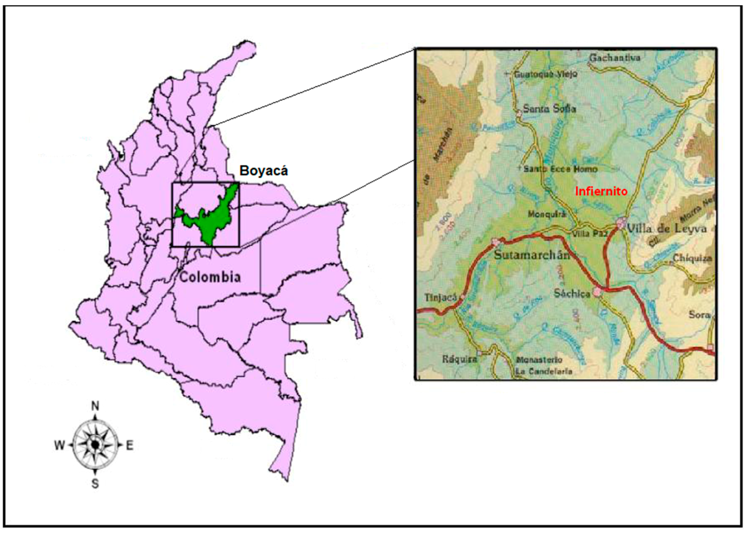
Figure 1.
Map of Colombia, South America, and the Department of Boyacá with an inset showing the locations of Valley of Leiva, the site of El Infiernito, Villa de Leyva, as well as other towns/sites throughout valley.
Figure 1.
Map of Colombia, South America, and the Department of Boyacá with an inset showing the locations of Valley of Leiva, the site of El Infiernito, Villa de Leyva, as well as other towns/sites throughout valley.

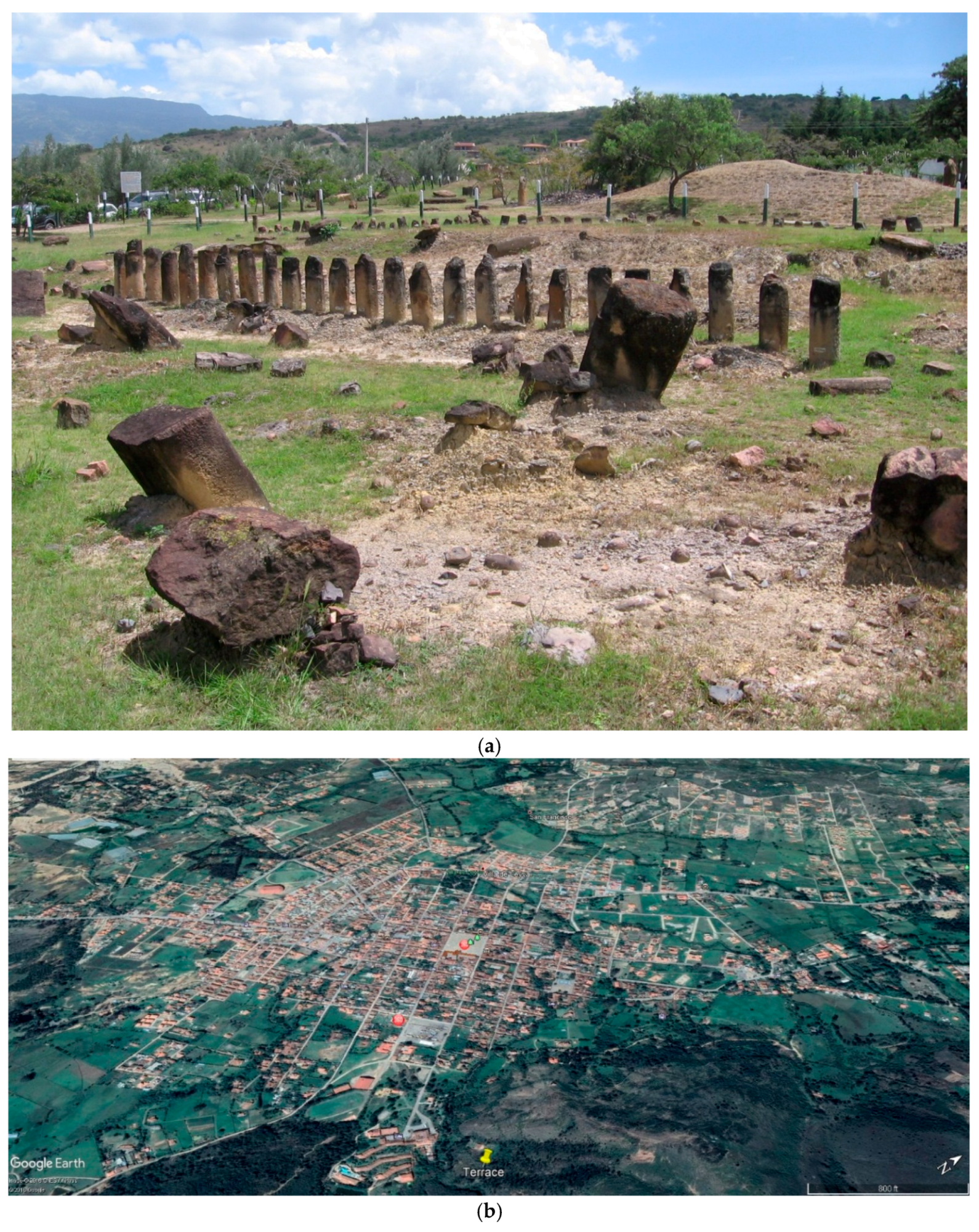
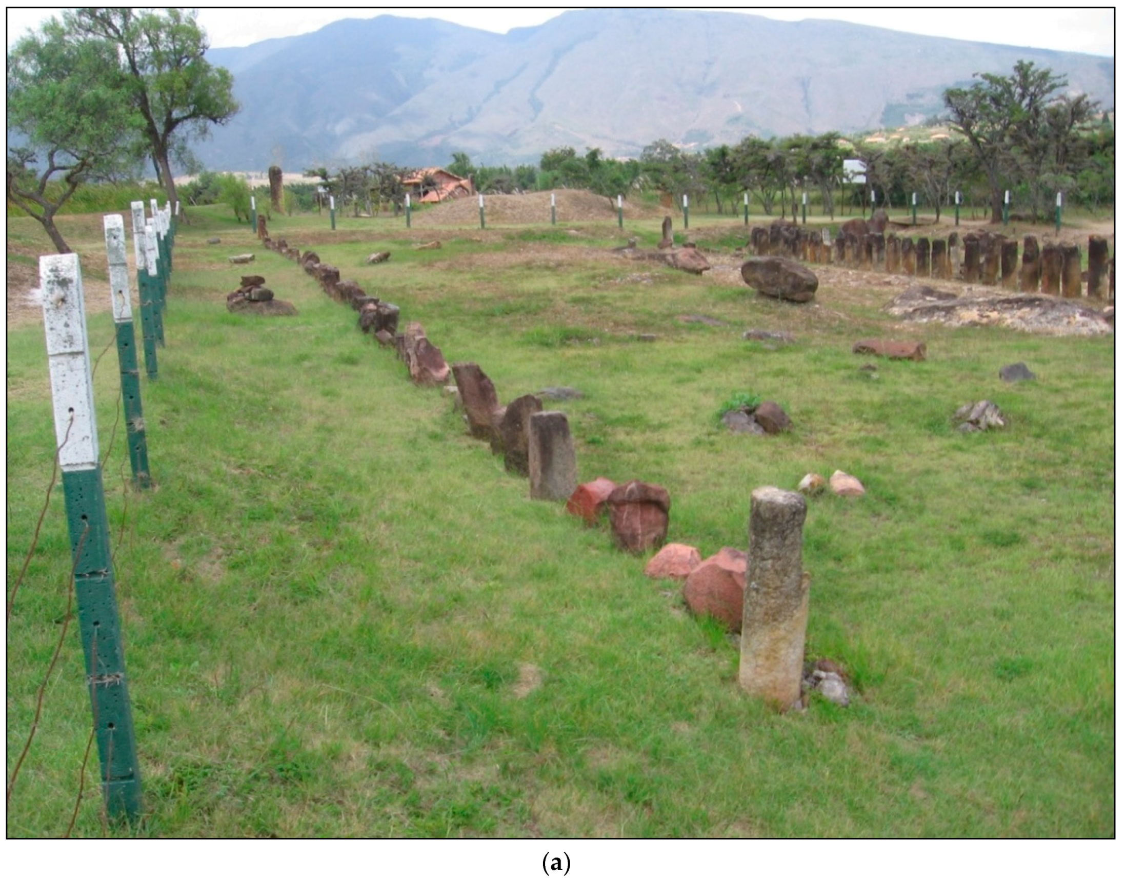
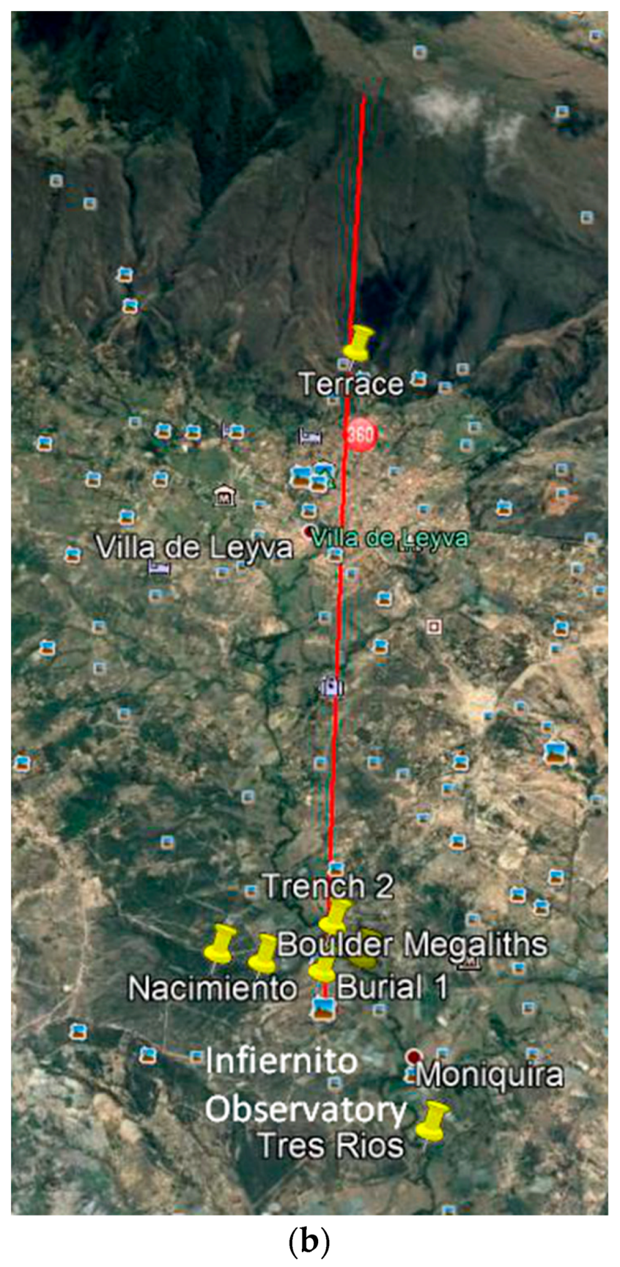
Figure 2.
(a) Photo of El Infiernito Observatory looking northwest showing two rows of stone columns and various monoliths many reconstructed by Eliécer Silva Celis in 1981. The Loma la Cabrera is seen in the background; (b) Google Earth satellite image of Villa de Leyva and the Terrace Platform. The Grand Plaza is located near the photo center and the Quebrada San Agustín runs east to west north of the center of town before emptying into the Rio Leyva (top center).

Figure 3.
Photo of eight carved limestone and sandstone portrait statues from a private collection exhibiting typical Muisca decorative symbols and motifs. These statues allegedly found near the Terrace Platform appear to be deity or elite figures associated with fertility (Bachué) and the origin myth of Iguaque.

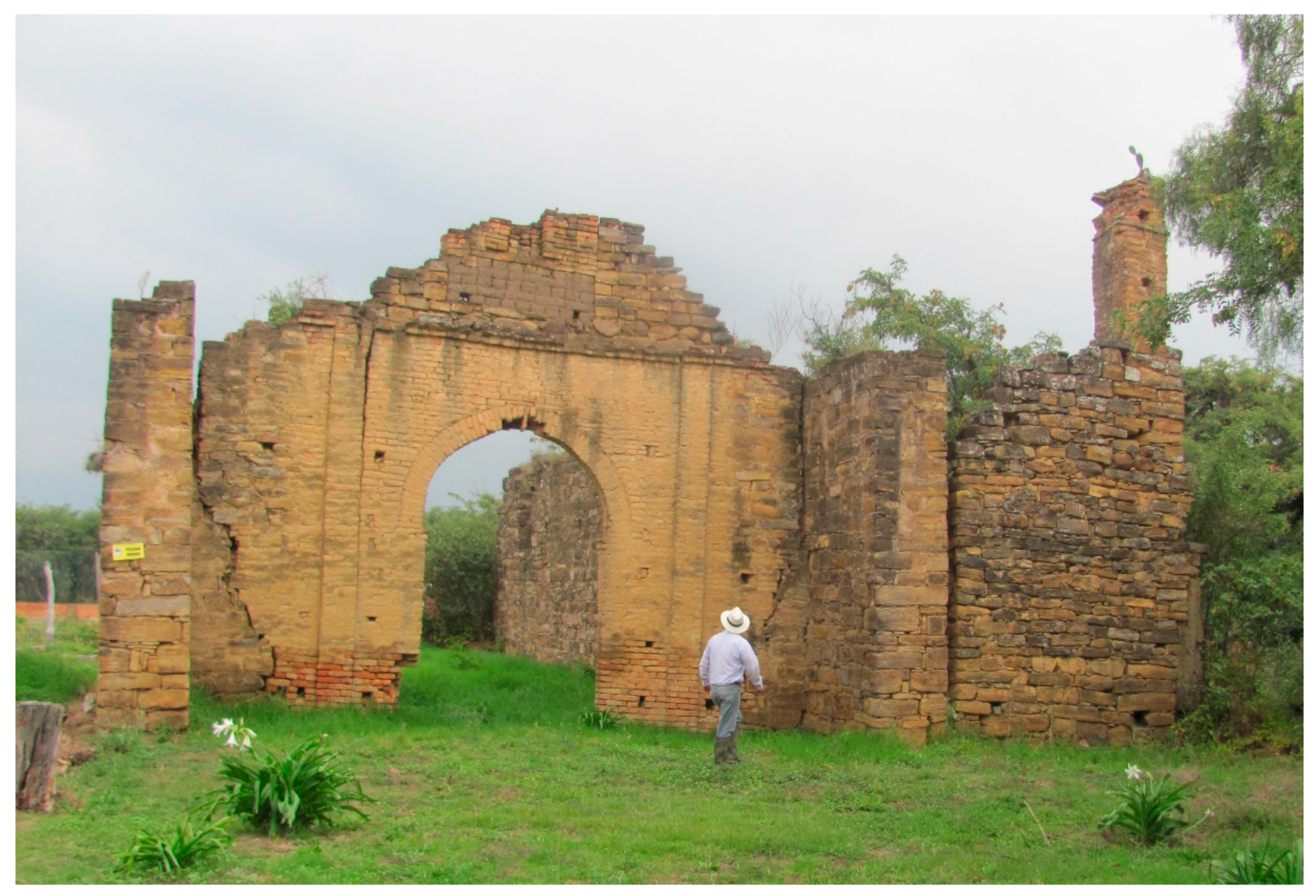
Figure 4.
Ruins of the Dominican church at Monquirá, the largest structure remaining from the 1553 Spanish settlement in the Valley of Leiva.
Figure 4.
Ruins of the Dominican church at Monquirá, the largest structure remaining from the 1553 Spanish settlement in the Valley of Leiva.

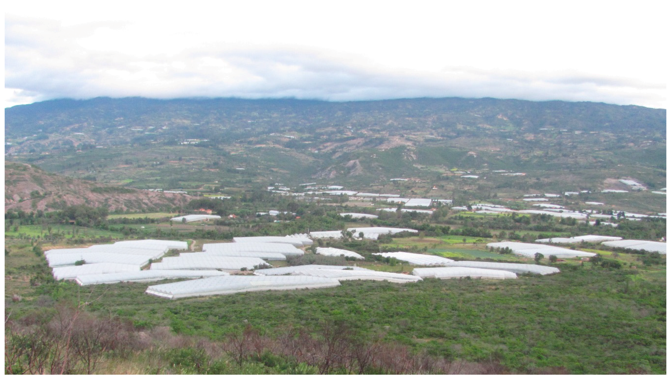
Figure 5.
Photo of the Leiva Valley looking west showing polycarbonate-covered greenhouses (invernaderos) and truck farms distributed across the river valley alluvium and into the uplands.
Figure 5.
Photo of the Leiva Valley looking west showing polycarbonate-covered greenhouses (invernaderos) and truck farms distributed across the river valley alluvium and into the uplands.

Figure 6.
(a) Photo of the north row (westernmost column) and south row (easternmost column) of El Infiernito Observatory looking along a true north diagonal azimuth for the Winter Solstice (~113°) aligning with the terrace platform-water temple, mountain water fissures for the Rio Leyva, and peaks of the Iguaque Mountains and Cerro Santo in distance; (b) Google Earth satellite image of the Leiva Valley and Rio Leyva illustrating the true north azimuth (112°) of the Winter Solstice (red line) from the El Infiernito Observatory to the terrace platform-water temple, mountain water fissures for the Rio Leyva, and peak of the Cerro Santo some 7.118 km to the east-southeast where the winter sun appears on 22 December.


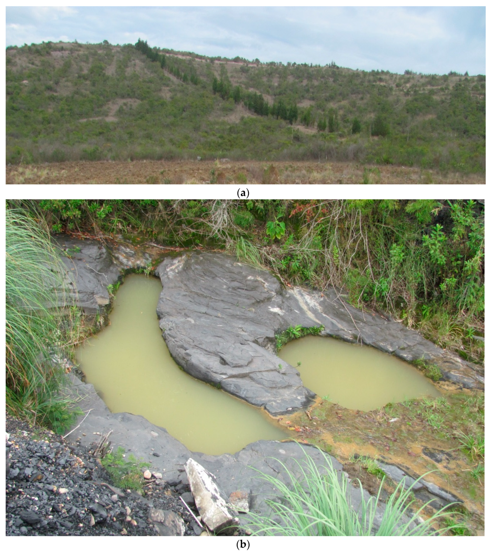
Figure 7.
(a) Photo looking west showing the Loma la Cabrera where the spring for the Cañada las Peñas is found associated with potential Musica irrigation features. (b) Photo of two possible anthropogenic ovoid pools within a carboniferous shale deposit below the spring for the Cañada las Peñas.
Figure 7.
(a) Photo looking west showing the Loma la Cabrera where the spring for the Cañada las Peñas is found associated with potential Musica irrigation features. (b) Photo of two possible anthropogenic ovoid pools within a carboniferous shale deposit below the spring for the Cañada las Peñas.

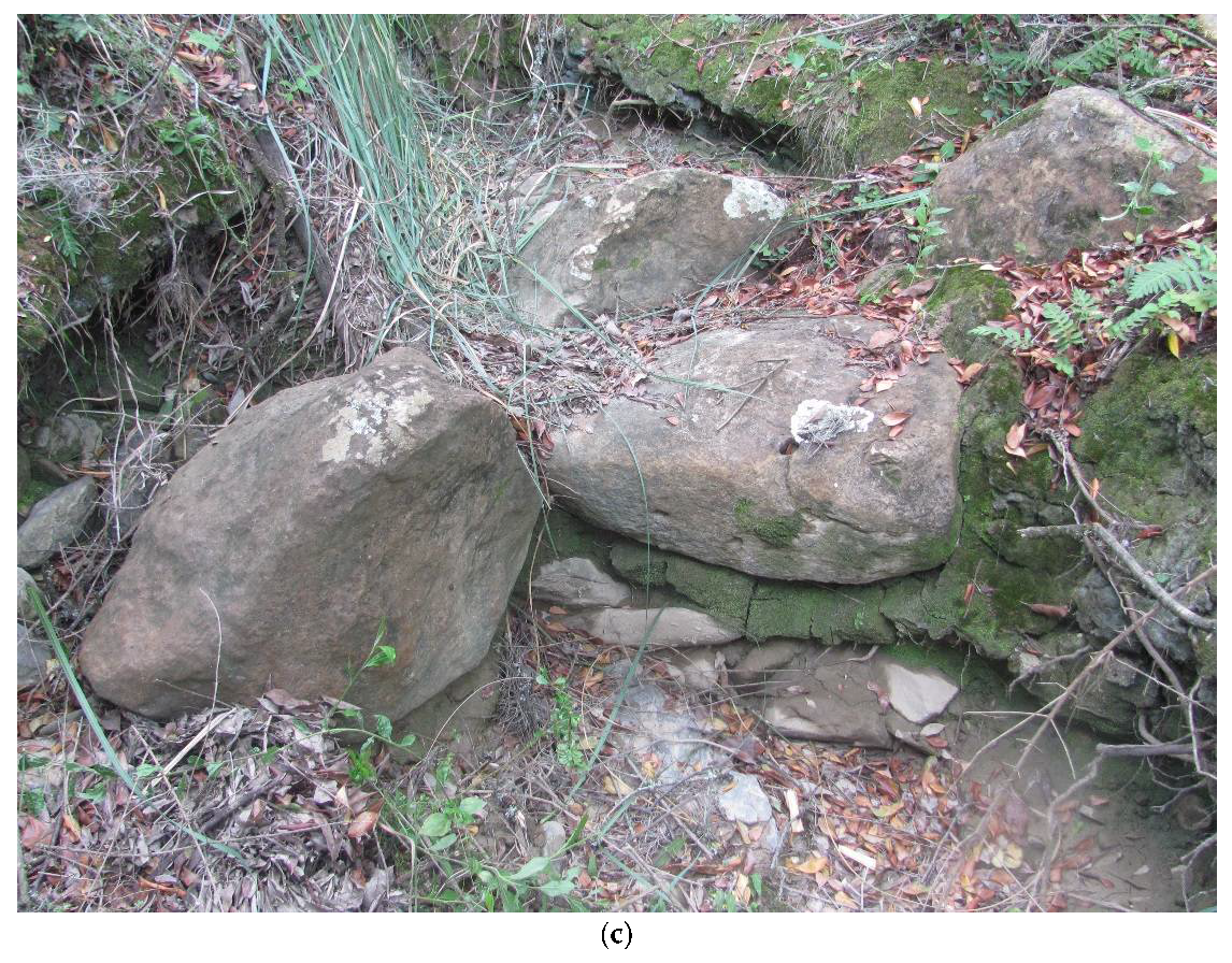
Figure 8.
(a) A drainage conduit below a catchment surface upstream associated with a boulder stone reservoir; (b) Photo looking northeast of a potential hydraulic feature showing shaped megalithic boulders once standing upright and now partially displaced that served as walls for a reservoir above a check dam and downstream from a catchment zone and linear drain conduit. The boulder at the bottom is about 2 m long; (c) A stone check dam below the boulder stone reservoir.


Figure 9.
Geomorphologists examining soil stratigraphy at Trench 1 where evidence for a stream channel was identified between the Loma la Cabrera and the Rio Leyva.
Figure 9.
Geomorphologists examining soil stratigraphy at Trench 1 where evidence for a stream channel was identified between the Loma la Cabrera and the Rio Leyva.

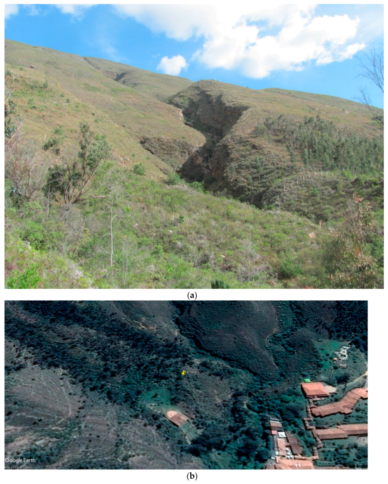
Figure 10.
(a) Photo looking east-southeast towards the peaks of the Cerro Santo and the mountain water fissures and stream channels adjacent to the terrace platform where the sun of Winter Solstice rises; (b) Google Earth image of the Terrace Platform atop a leveled hill adjacent to stream channels north of the Hotel Duruelo.

Figure 11.
Photo of the megalithic terrace tiers (or stairs) along the west side of the hill leading to the terrace platform-water temple. Dry stone masonry with abundant chinking stones and Prehispanic and Early Colonial ceramics were associated with this stone structure.
Figure 11.
Photo of the megalithic terrace tiers (or stairs) along the west side of the hill leading to the terrace platform-water temple. Dry stone masonry with abundant chinking stones and Prehispanic and Early Colonial ceramics were associated with this stone structure.

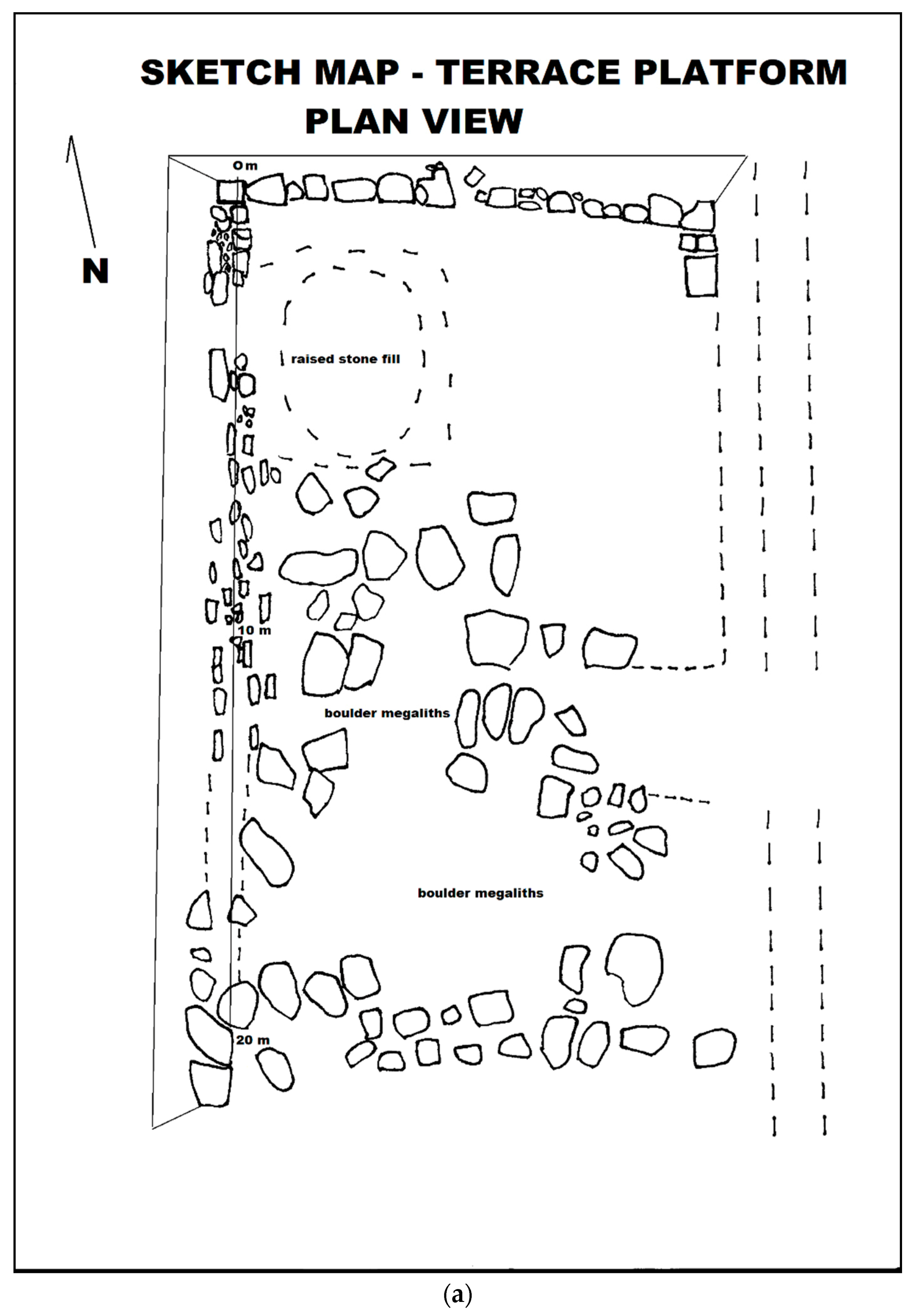
Figure 12.
(a) Plan view sketch map of the Terrace Platform showing north and west retaining walls, a northwest area of stone fill or pavement possibly for a circular temple (uta), and numerous shaped-carved monoliths and alignment for a division or platform border area. The platform is terraced on the south and east sides leading down to water. Ceramics of all Muisca time periods were found on- and off-platform; (b) A modern replica of a Muisca house (uta) temple at Lake Guatavita, a famed place of the El Dorado legend, that is perhaps similar to a water temple that was once stood on the Terrace Platform.


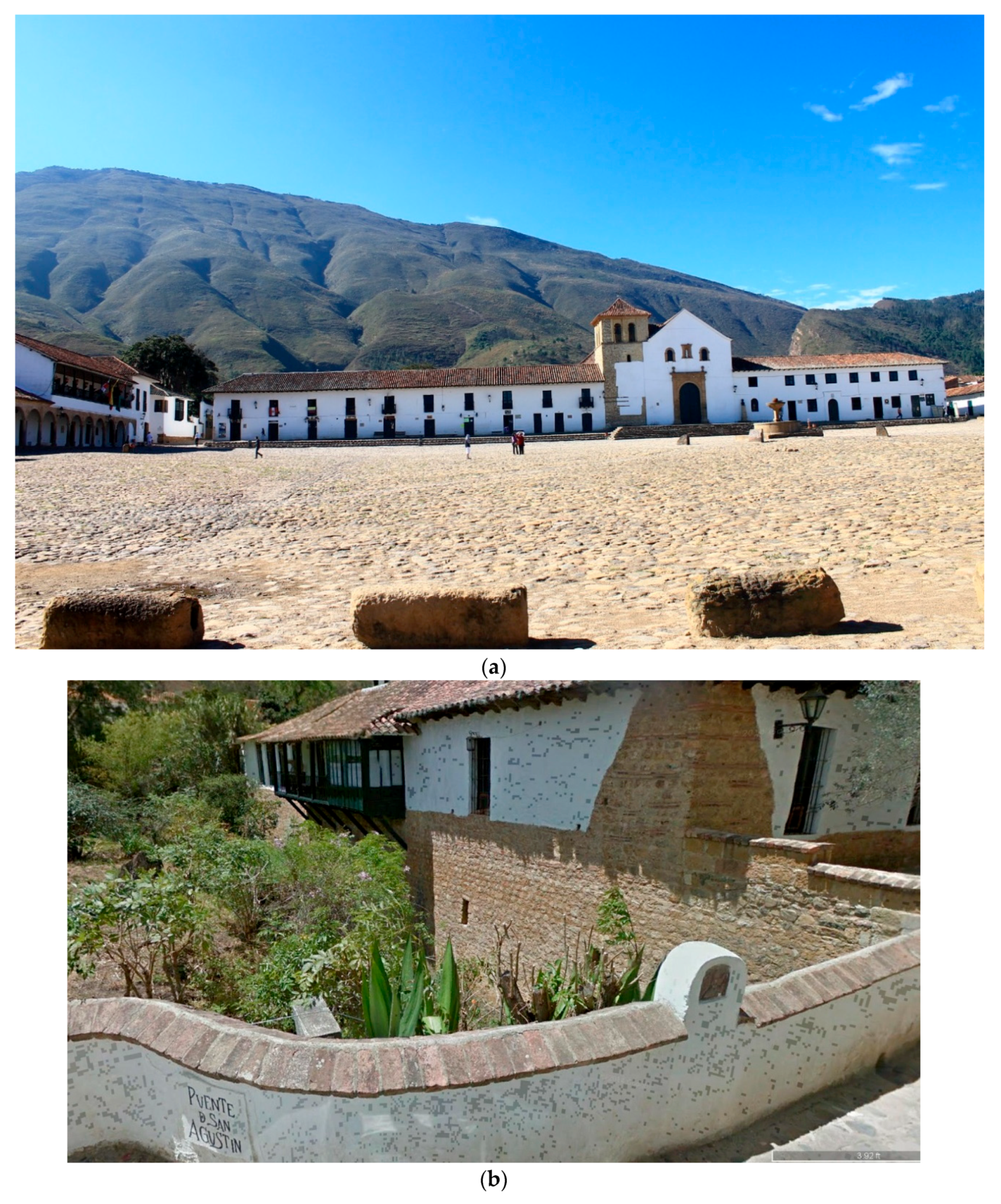
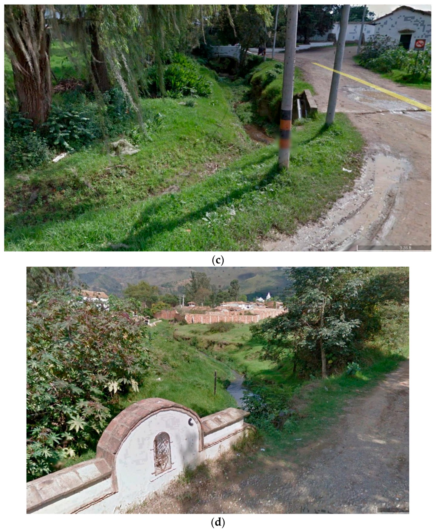
Figure 13.
(a) East view of the Colonia heart of Villa de Leyva showing the Plaza Mayor and the Parroquial de Nuestra Señora Santa Maria de Leyva with the Cerro Santo in the background; (b) West view of a Colonial bridge (El Puente de San Agustín) at Carrera 10 where the Quebrada San Agustin flows through Villa de Leyva by the Iglesia El Carmen; (c) An east view of the Quedrada San Agustín flowing through canals parallel to the streets of Villa de Leyva. (d) The Quebrada San Agustín flowing out of Villa de Leyva before joining with the Rio Leyva on the way to the Infiernito Observatory.


Figure 14.
(a) Stone-lined stream channel of the Quebrada San Agustín located downstream from the Terrace Platform that may have been artificially altered in Muisca times. Modern, Colonial, and Prehispanic potsherds were seen eroding from the stream banks; (b) Upstream water pool of the Quebrada San Agustín just west of the Terrace Platform showing debris from recent flooding events; the limestone outcrop in the background appears to have been worked suggesting an anthropogenic construction.

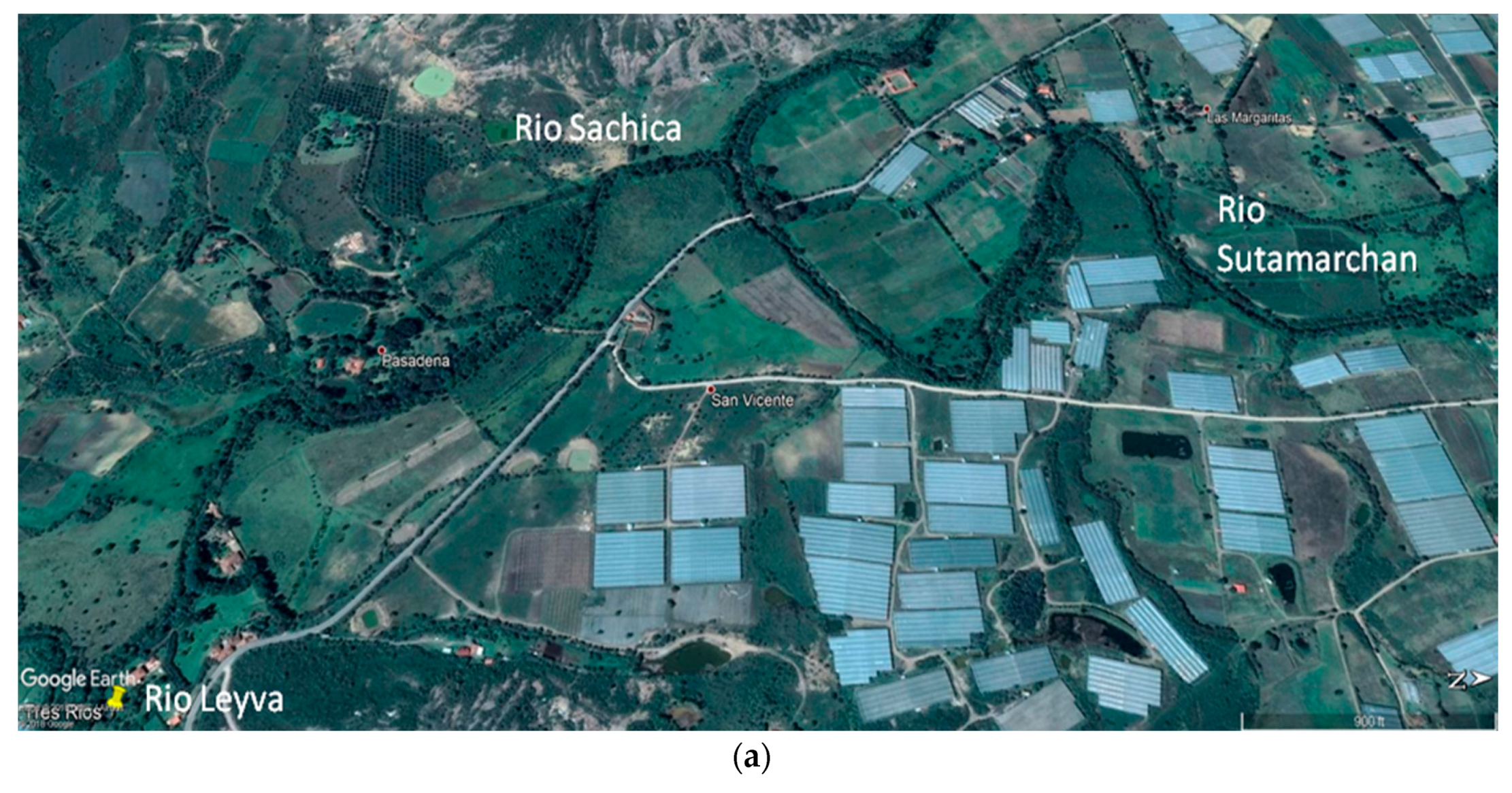
Figure 15.
(a) Google Earth satellite image showing the confluence of the Rios Sáchica, Sutamarchan, and Leyva near Monquirá where Muisca raised-field agriculture is argued to have been practiced on the same alluvial plain where industrial-scale agriculture (San Vicente) occurs today; (b) Levees along the Rio Leyva near Monquirá.


© 2018 by the author. Licensee MDPI, Basel, Switzerland. This article is an open access article distributed under the terms and conditions of the Creative Commons Attribution (CC BY) license (http://creativecommons.org/licenses/by/4.0/).
Share and Cite
MDPI and ACS Style
Smyth, M.P. Hydraulic Chiefdoms in the Eastern Andean Highlands of Colombia. Heritage 2018, 1, 100-121. https://0-doi-org.brum.beds.ac.uk/10.3390/heritage1010008
AMA Style
Smyth MP. Hydraulic Chiefdoms in the Eastern Andean Highlands of Colombia. Heritage. 2018; 1(1):100-121. https://0-doi-org.brum.beds.ac.uk/10.3390/heritage1010008
Chicago/Turabian StyleSmyth, Michael P. 2018. "Hydraulic Chiefdoms in the Eastern Andean Highlands of Colombia" Heritage 1, no. 1: 100-121. https://0-doi-org.brum.beds.ac.uk/10.3390/heritage1010008