Archeological Heritage in the Area of the Jewish Ghetto in Rome: Surveying and Reading Among Archetypes and Memories of the Past

Engineering Faculty, Università Telematica Internazionale UNINETTUNO, 00186 Rome, Italy
Heritage 2019, 2(2), 1499-1508; https://0-doi-org.brum.beds.ac.uk/10.3390/heritage2020094
Submission received: 9 April 2019
/
Revised: 13 May 2019
/
Accepted: 14 May 2019
/
Published: 26 May 2019
(This article belongs to the Special Issue Sharing and Discussion of Experiences and Approaches to Interpretation, Conservation and Management of Archaeological and Architectural Heritage)
Abstract
:This paper, part of a larger project of the Faculty of Should it be 00186Engineering of the International Telematic University UNINETTUNO (PRIN2010PEA4H8, Research Plan of National Interest, co-financed by the Italian Ministry for University Research), aims to provide documentation on the historical and archeological relevance of the Jewish Ghetto area in Rome, which is a site with numerous extraordinary features and memory traces of the past. The methodology adopted was mainly based on surveying activity—urban, architectural, and archeological—as well as the subsequent comparison of data obtained, investigating, and cataloging this tangible historical heritage and its relations with the archaeological heritage using the instruments of representation and surveying. Additionally, a different approach aimed at identifying a link between the subjective narration of the historical city and its objective description through the integration of digital methods of the cataloging and management of cultural heritage is applied.
1. Introduction
Some historical cities represent an extraordinary sample for research, where the presence of a dense cultural, iconographic, and mnemonic heritage translates into an extraordinary variability of values that broadens and structures the perceptual fluidity already typical of every urban context. Historical sites, inherent in the meshes of its stratifications, bear the very essence of variability, which can be read in the mutability of memories of the past, in the heterogeneity of forms, and in the variety of archaeological and architectural heritage [1]. This stretch of instability, generated mainly by the mutability of the past, is also enriched by the contemporary dynamics of the historical place, which evolves into a complex path in search of a balance between its identity essence and the new needs of the contemporary. A typical case and a feature of common recognition in many historic cities is the presence of Jewish ghettos [2]; these are tangible memories of the existence of Jewish communities in European cities that have returned pieces of cities evolved through successive stratifications and which, again, reveal consolidated conditions of formal and architectural equilibrium, creating extraordinary urban realities for cultural and identity heritage rooted atavistically in the historical city. Through an urban plant and morphological shape developed thanks to clerical orders, the Jewish Ghetto of Rome expresses a cultural, iconographic, and mnemonic heritage rooted in the capital [3]. These particular aspects, so visible in the archeological heritage, urban setting, and monuments, are based on a variability of architectural episodes spanning from contexts of prominent archaeological interest up to the most recent historical, in historical layers evolved in a miscellaneous manner until being transformed as a consolidated conditionof architectural and functional balance [4]: The coexistence of many historical testimonies from different eras in a delimited and identifiable urban area makes the Jewish Ghetto of Rome an excellent sample for research, aiming to perform the integration of several surveying methods and the consequent critical comparison of the results.
2. Materials and Methods
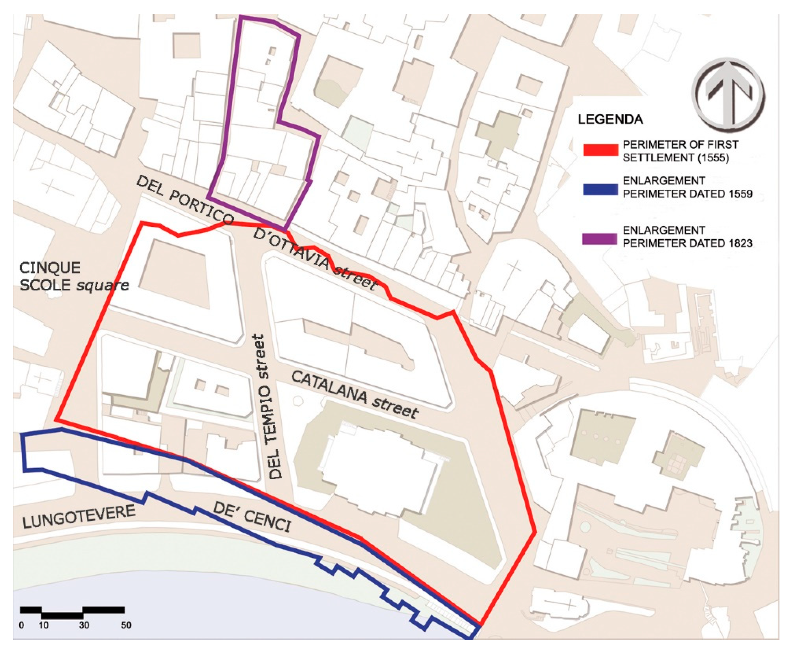
The Jewish Ghetto of Rome occupies an area located in the center of the capital. The morphology and urban shape of the Ghetto as it is now evolved in three main steps, plus a fourth one providing the modern conurbation (Figure 1); such a process of development is in accordance with the provisions arising from the alternation of the relationship established, from the Middle Ages to the Renaissance, between the various Popes and the Jewish people [5].
The last aggregate dates from 1823, along the shore of the river (Figure 1), and was demolished with the work started in 1888 for the construction of the embankments of the Tiber and the urban renewal that set the shape of the “modern” morphology of the Ghetto.
Even the immediate surrounding areas that form the Rione XI (as the axis of via del Portico di Ottavia and the insula bounded by the upstream cross the so-called Via della Reginella and Via Sant’Ambrogio) have not lost their original characteristic essence. These features preserve the legacy of a tangible memory from which the genius loci transpires, perceived through a combined sensory involvement that relates sight, smell, and sound. Undeniably, this peculiar aspect is much more often found in those areas that survived the many demolition interventions, such as the demolition of the area around the theater Marcello carried out between 1926 and 1930. This work, while enhancing a more appropriate usability of the ancient ruins of the theater, resulted in the disappearance of some parts of meaningful features, such as piazza Montanara or Via Catena di Pescheria [6].
The different interventions over the years can be read through the identification of the main “cornerstones”—or rather, the most important archaeological elements—that correspond, almost always, to the founding elements of the area.
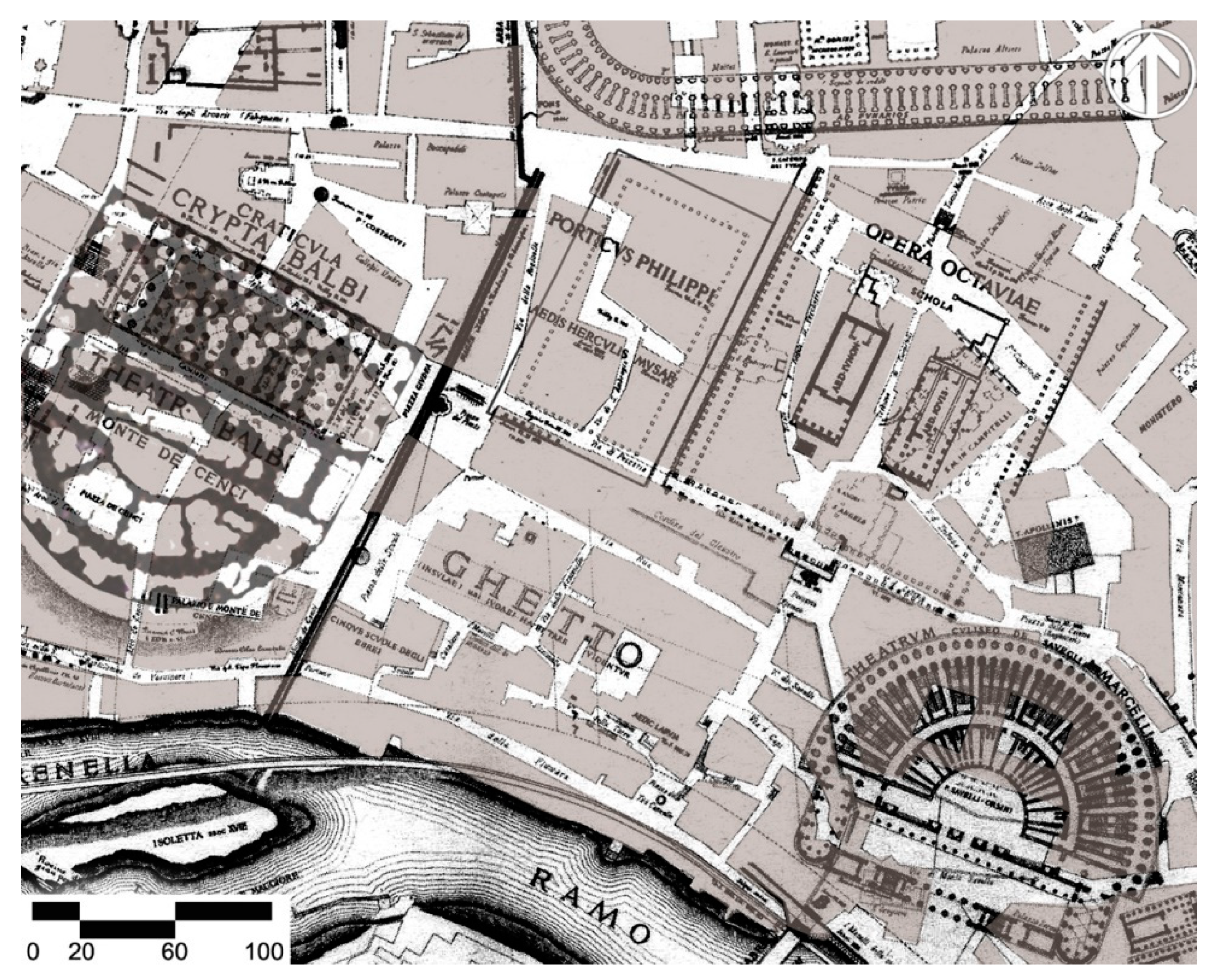
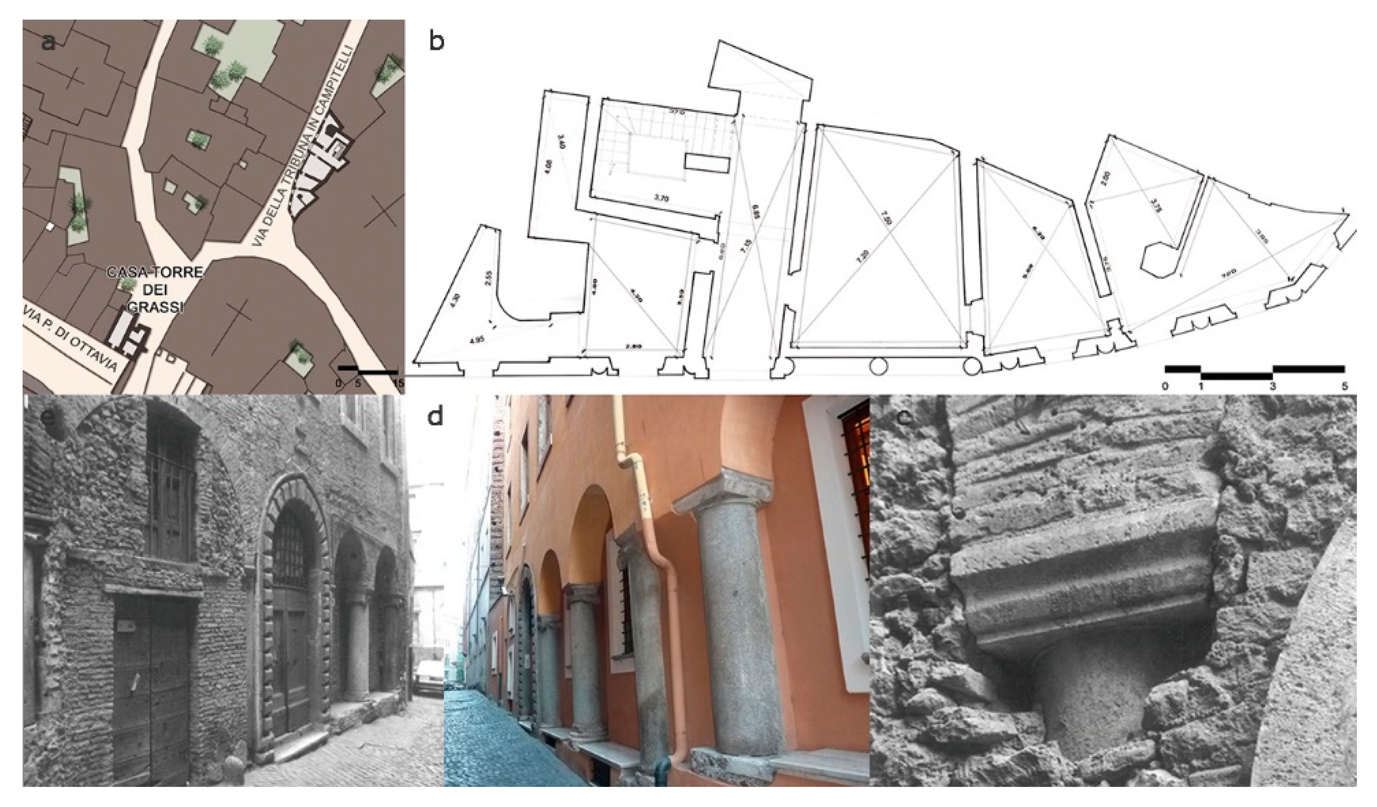
In the map “forma urbis”, the Lanciani returns the overlapping of the main pre-existing Roman reperts in the Ghetto area; it is possible to note how the locations of the circus Flaminio and theater Balbo with adjoining crypt were considered as such until the 1960s when, thanks to the work of G. Gatti, what is currently the most reliable location found, which sees the Balbo theater, as well as the Crypt of the same name, coincident with the so-called isolato Mattei (Figure 2 and Figure 3). The area bases its urban plant in the heart of the imperial city [7]. The relationship with the archaeological heritage is so obvious that the same remains of the past contribute, still today, to defining the architectural layout of the place; when drawing the archaeological remains on a 19th century map and, then, overlap this drawing on the current urban layout, it is possible to see the density and quality of the archaeological heritage (Figure 3). This heritage includes the Teatro Marcello, that is still visible in part of its original extension, and the Portico of Octavia, whose propylaeum the original extension is still visible in the area behind, which developed in later times around the Church of Santa Maria in Portico in Campitelli (Figure 4). Nearby the curtain of buildings along Via della Tribuna di Campitelli develops, that starting from the little square of Sant’Angelo in Pescheria develops near the church of S. Maria in Portico ai Campitelli, which stands on the grounds of the original plant of the Portico of Ottavia, incorporating some of the columns in the masonry. Other memories of the original propylaeum stand out in front of the medieval house called “casatorre dei Grassi”, named after the family who bought it from the Orsini family in 1369, leaning against the propylaeum of the Portico of Ottavia.
The Archeological Heritage
The Portico of Octavia is the reference point of the over-planning of different archeological layers. The archeological excavations have unearthed only the half upper of the columns of the Portico di Ottavia that, in the imperial age, must have been much higher. Nearby, the remains of the Portico di Filippo, smaller and leaning against the largest one entitled to Octavia, the sister of Augusto, is incorporated in the building known as the Casa dei Fabii; the drawing highlights the historical stratifications that can be seen, still today, in the structure of the building (Figure 5). Next to these important settlements, incorporated in the building block known as Casa Mattei, the remains of the Teatro Balbo with adjoining crypt have been identified, along with the track of the Circo Flaminio downstream. The exact location of these two important findings is due to the studies of G. Gatti who, in the 1960s, placed the theater Balbo as coinciding with the so-called isolato Mattei.
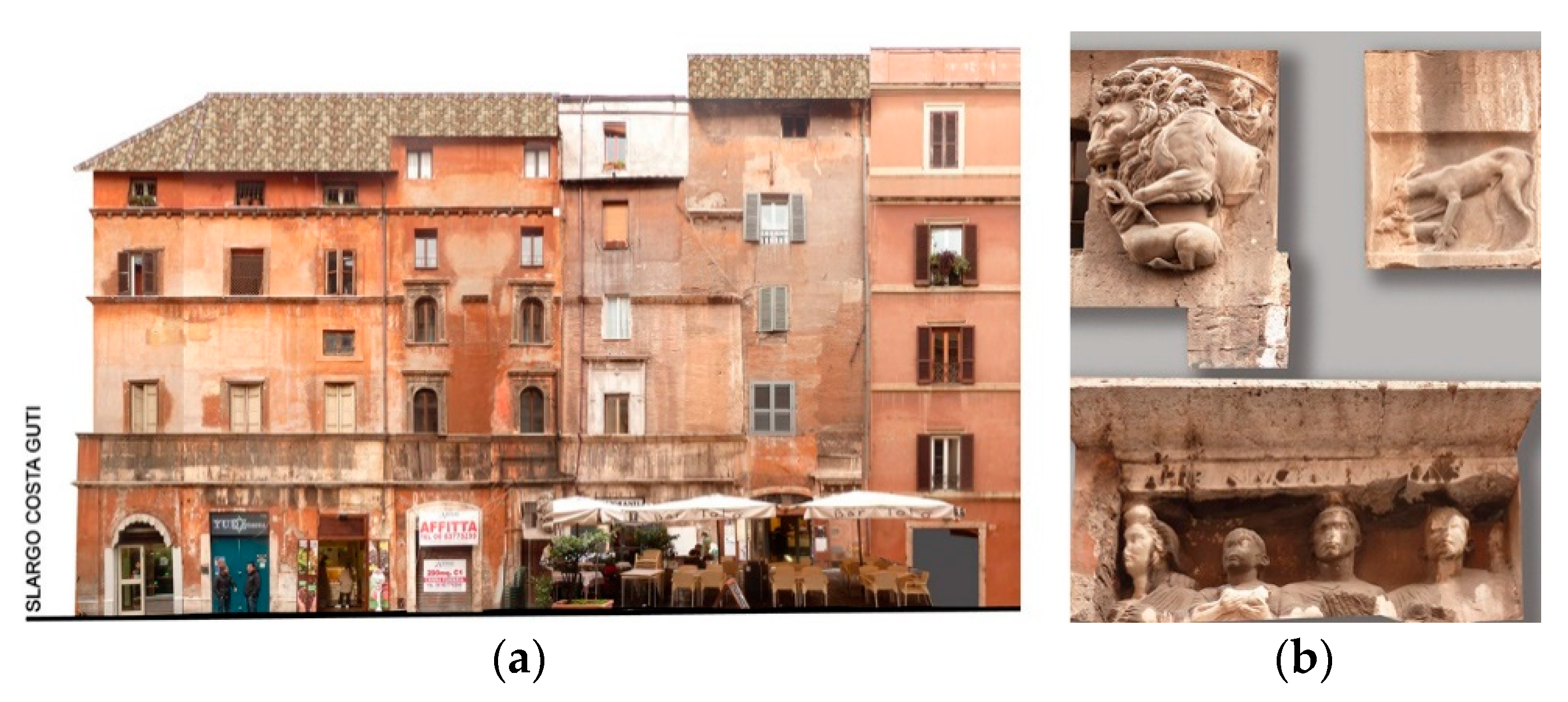
Today, there are no easily visible parts of the ancient Portico di Filippo. Under the sidewalk of the fifteenth-century palace called Casa dei Fabii, during the survey of the foundations of the building, a large granite column belonging to the Portico di Filippo was found. The column was part of the propylon of the Portico di Filippo, that used to stand next to the bigger one of Ottavia, and which reached Piazza Mattei. The structures and ancient wall around the column were transformed and rearranged in the later ages, and extended near the block between the streets of Via della Reginella and Via Sant’Ambrogio, where a walled-up door was found as if there once had been an underground walk-way. In the part of the area towards the river was the Circo Flaminio, a big arena mainly used for “plebeian games” [8]. The largest marble slabs (travertine) that paved the floor of the arena, were found at about four meters under the current streets, and squares, extending below Via Del Tempio, Via Catalana, and Piazza delle Cinque Scole, forming a very large area leading down to the banks of the river Tiber. The ground floor as well as in the basement of the 15th building called Casa di Manilio are important pre-existing remains that consist of the complex known as “casa manliana” with the characteristic inscription bearing the declaration of love by Lorenzo Manilio for his city being of particular interest; on the façade, there are interesting fragments of archaeological nature. Marble fragments from different periods can be seen in its facade, along with a sculpture and fragment of an ancient sarcophagus of Egyptian origin (Figure 6). On the corner of this building, in the vertical of the second ancient sewer of the area, parts of a column of the Circo were found. The date of the building is 1221 the founding of the city (753 BC), the year 1468.
3. Discussion: Knowledge and Approach of Survey
The surveying activity in the area of the Jewish ghetto in Rome is part of a larger research project co-financed by the Italian Ministry of Universities and Research [9].
The site of interest has been the subject of extensive studies over time; this contribution aims to integrate the patrimony of knowledge already available, researching and providing the elements for an overall perception of the whole urban area, in its entirety today, while also attempting to discover and catalog the many episodes of archaeological heritage.
This cannot exclude a survey phase of this heritage, with a representation of the most significant area of the Ghetto, to determine and document a comprehensive and contextual reading through the interpolation of the shares of the architectural and archeological survey.
This paper focuses the analysis of the conformation of urban portions of this area, surveying, in particular, the presence of the archeological remains and archetypes present in the texture of the architectural heritage of the Ghetto. The survey was extended mainly to the remaining area of the original extension of the Ghetto, along with Via del Portico d’Ottavia, which retains some of the “archaeological cornerstones”, such as Portico di Ottavia and Portico di Filippo.
3.1. The Urban and Architectural Survey
An important phase of the research is the survey of the existing buildings that form the remaining original architectural texture in the original boundaries of the Ghetto. Many streets have a somewhat reduced width, on average by about three meters and elevation of the fronts by over 15 meters. Planning the survey in these conditions needed to take into account the difficulty of taking quality photographs, useful both for documentation purposes as well as subsequent photogrammetric elaboration, at least above a certain elevation. Under these conditions, for the most elevated parts of the buildings, the contribution of the on-site drawing was greater than that from the photographs (Figure 7). Laser scanning proved useful in some areas where the operating conditions were such as to prevent, for example, pictures proposed in orthogonal projection or even views of the tops of buildings. This was also the case of the urban fronts along Via di Sant’Ambrogio, very tall and facing a very narrow road (Figure 8).
3.2. The Color Survey
The survey of the colors is an indispensable instrument to obtain complete knowledge of the site. This type of survey does not deal exclusively with the plastered surfaces, but studies the set of components of the external surfaces of the architectural shape (stone elements, wood and iron elements, shelves, windowsills, and any other decorative apparatus and functional competitor to form the overall perception of the exterior of building units). The color survey does not “simply” represent a catalog of the chromatic gradations that can be found, but rather relates more generally to the perceptive system of the city. Methodologically, the color survey was carried out through a careful activity of cataloging [10]. All the information obtained from the investigation activities was collected in many survey schedules, in which the architectural and chromatic features of the buildings were registered (Figure 9). The cards have two parts. The first part is organized in three sectors: the first relating to the identification of the card, the second contains all the information for identifying and locating the prospectus and the third that contains its chromatic characteristics. The second part is organized into two sectors: the first dedicated to the general notes and the second to sampling and photographic references. The chromatic scale used as a standard reference is NCS (Natural Colour System) index 1950 [11].
3.3. The Immaterial Survey: Time and Movement
In this paper, in addition to the more usual approaches aimed at the knowledge and dissemination of heritage through the instruments of survey and representation, the topic is focused through diverse methods of approach on the perception of the heritage. The question is: While inhabiting a static space, do humans perceive space as changeable and dynamic? In this way, it is possible to say that representing mutations and transformations, therefore, means representing the space perceived (and thus, the urban shape), recovering the relationship between mind and space [12].
It is possible to think that reality (and so a building, the architectural heritage, a whole historical sites) is different and contains infinite realities since it expands and multiplies over time to subvert the temporal logic: past–present–future.
The dynamism inherent in the urban landscape, also due to the changing of its exogenous and endogenous conditions, defines infinite perceptive possibilities, while the representation of the historical city is ordered, also, on the changeability of the context and on the perceptive capacities of the observer: “Ability to read the real not as permanent present but as a dynamic reality from which to grasp the traces for the construction of a new vision of the past” [13]. The urban shape changes over time due to endogenous and exogenous phenomena.
However, if many of these phenomena are documented through the consolidated instruments of the representation, there are other immaterial phenomena, such as the light or the passage of moving bodies, which modify the space at a perceptive level.
These considerations are also the highest expression in the representation of the historical city, where the influence of a dense heritage strongly influences the perceptive dynamics as well as the reading of the context.
3.4. The Reconstruction of the Ancient Plant
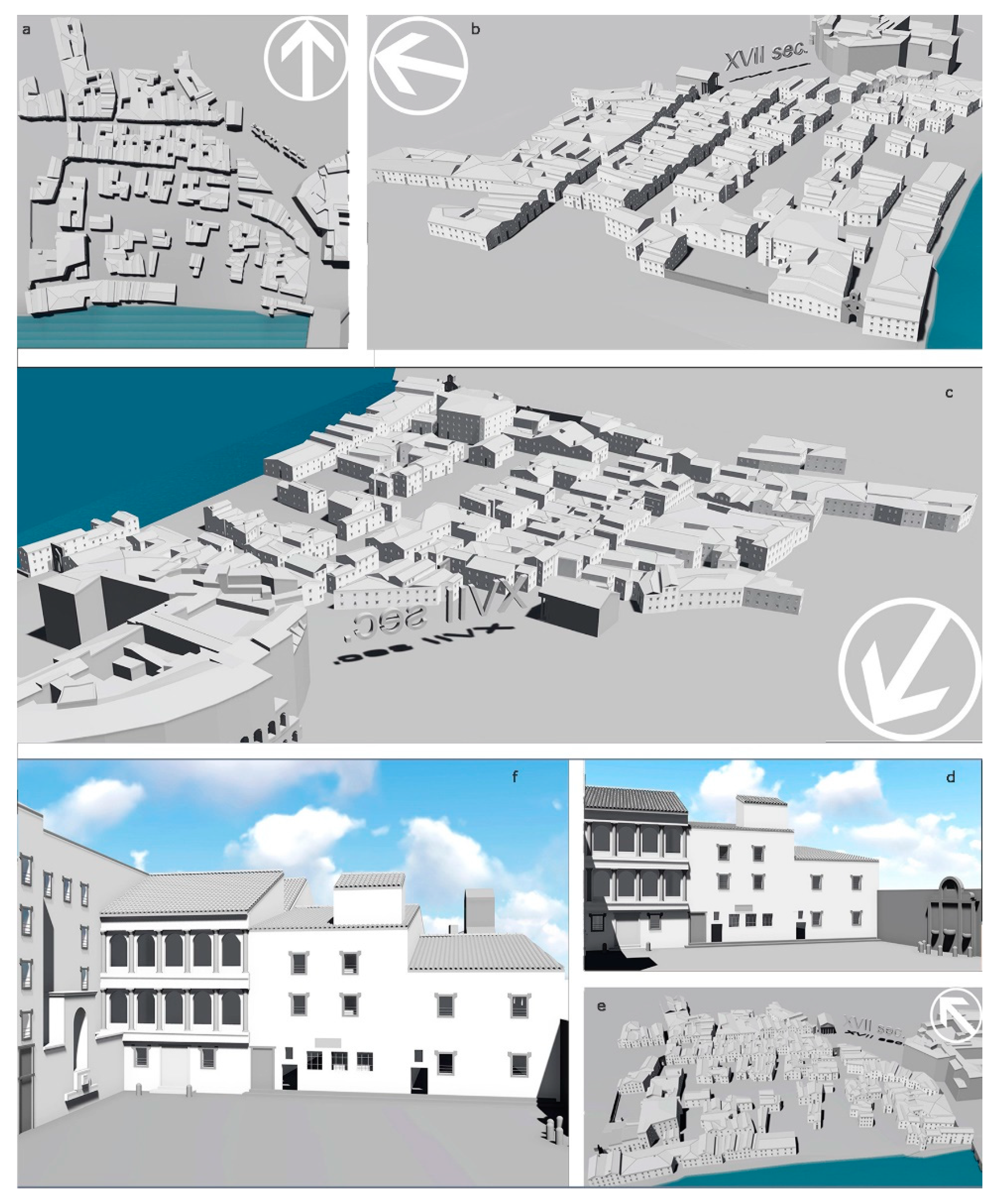
An important activity, to locate and correlate the archaeological heritage in the area, involved the virtual reconstruction of the ancient Ghetto or rather, the buildings that have characterized the morphology of the place towards the end of the seventeenth century (Figure 10).
There are two primary reasons for the choice of this period: The first is that at this date, the view of the place is completed by the presence of both the main settlements, built in 1555 by Paolo IV, who imposed the construction of the walls with only three doors, with the second expansion, implemented at the end of the same century by Sisto V, close to the banks of the Tiber, that formed a new settlement of extension parallel to a first portion of the river, accessible by two new doors.
The second reason is that the Jewish Museum of Rome carried out, in December 2014, a reconstruction of the site at the end of the nineteenth century, before the radical intervention of urban transformation that has given the current morphology of the area. In 1888, the Bank Tiberina carried out a restoration intervention with the demolition of the ancient building texture, construction of river embankments as well as the building of the four main compartments, with the new Synagogue. The 3D modeling was, therefore, carried out based on certain representations of the time. Among these, the documentary views are highly significant: Du Pérac 1574, Merian 1642, and Falda 1676 represented almost all with a bird’s eye view from the south-west to north-east. The finding of these iconographic sources has made it possible to reconstruct—even if only volumetrically—the Ghetto at that time, resulting in the possibility of comparison with respect to subsequent developments. An interesting datum is related to the reconstructions of monuments that no longer exist, such as the building of Cinque Scole, at the end of the seventeenth century. The Pope had forbidden the existence of more than one Synagogue, so the Jewish people in one single building had concentrated their five different Synagogues, divided according to origin and rituals, between the floors. The building of Cinque Scole was the last building to be demolished at the end of the 19th century. There was one entrance that led to the various floors. The first Jews, who arrived in Rome before Caesar, belonged to the “Scola Tempio”, the others the “Scola Nova”. The Jewish people who come from Spain belonged to the “Scola Catalana” and the “Scola Castigliana”, architecturally the most important with its characteristic arches and Moorish traits.
4. Conclusions
The contribution of this research, whose main aim is the knowledge and critical reading of the architectural and archaeological heritage, is mainly revealed in the ability to integrate different methodologies of survey, analysis, and representation. Among these, we have also expanded the relationship between the heritage perception and the time, codifying the roles that time has in the representation of heritage.
The main result of these studies is that the cultural heritage, as well as the entire historical city, is subject to an infinite variability of reading approach. One of the objectives of this research was to experiment and study in greater detail the use of the digital technologies for the identification and dissemination of the cultural heritage, increasing the digital archives and the creation of static and dynamic 3D models [14]. In these specific topics, the role of the representation instruments, based on the survey and 3D modeling, confirms how it is obligatory for the development of the processes (when their use are codified through a rigorous methodological approach); the drawing contains, still today, the expressive capacity to allow for the perception of an a-physic reality reproduced in a different spatial and temporal dimension. Thus, these methodologies and technologies are useful to integrate and define a semiological structure in an “advanced” way [15]; the possibilities offered by some innovative technologies, that allow for the transposition of the observer from an external to a participatory dimension, were very interesting in the field of this research. This transposition is implemented through the overcoming of the limit of the simply “active management” of the digital model, inducing in the observer a concrete participator’s perception of the digital reality; no longer a guest, not only the director but also the actor in a dynamic and integrated perceptive journey, aimed at the knowledge and dissemination of our heritage.
Funding
This research was funded by Italian Ministry MIUR—Ministero dell’Istruzione, dell’Università e della Ricerca, grant number PRIN2010PEA4H8.
Conflicts of Interest
The author declares no conflict of interest.
References
- Florio, R. Città Storiche. Città Contemporanee. Strategie di Intervento per la Rigenerazione della Città in Europa; Clean: Napoli, Italy, 2012. [Google Scholar]
- Foa, A. Andare per Ghetti e Giudecche; Il Mulino: Bologna, Italy, 2014. [Google Scholar]
- Benocci, C.; Guidoni, E. Atlante Storico delle Città Italiane. Roma. Il Ghetto; Bonsignori: Roma, Italy, 1993. [Google Scholar]
- Benedetti, S.; Fiorentino, L.; Listro, M.; Malusardi, F.; Mercurio, G.; Vittorini, M. Il Ghetto di Roma. Progetto di Recupero Urbano ed Edilizio; Kappa: Roma, Italy, 1995. [Google Scholar]
- Bevilacqua, M.; Fagiolo, M. Piante di Roma. Dal Rinascimento ai Catasti; Artemide Edizioni: Città di Castello, Italy, 2012. [Google Scholar]
- Frutaz, A.P. Le Piante di Roma; Istituto di Studi Romano: Roma, Italy, 1942. [Google Scholar]
- Muratori, S.; Centro studi di storia urbanistica. Studi per una Operante Storia Urbana di Roma; Tavola 7, Consiglio Nazionale delle Ricerche: Roma, Italy, 1963. [Google Scholar]
- Fiorentino, L. Il Ghetto racconta Roma; Gangemi Editore: Roma, Italy, 2005. [Google Scholar]
- Cennamo, G. Processi di Analisi per Strategie di Valorizzazione dei Paesaggi Urbani. Il Ghetto Ebraico di Roma, Brano di Città Storica; Ermes edizioni scientifiche: Roma, Italy, 2016. [Google Scholar]
- Iannotta, F. Il Rilievo cromatico dell’antico Quartiere Ebraico e del lato nord di Via del Portico di Ottavia a Roma. Rapporto di ricerca. In Cennamo, G., Processi di Analisi per Strategie di Valorizzazione dei Paesaggi Urbani. Il Ghetto Ebraico di Roma, Brano di Città Storica; Ermes edizioni scientifiche: Roma, Italy, 2016. [Google Scholar]
- AA. VV., IX Conferenza del Colore, atti del convegno (Firenze 2013). In Colore e Colorimetria Contributi Multidisciplinari; Maggioli Editore: Firenze, Italy, 2013.
- Marrocco, R. Observe in the course of time. Observe the transformations. From the survey of the physical space to the survey of the perceiveid space. In Italian Survey & International Experience, Proceedings of the Atti del 36° Convegno Internazionale dei docenti della Rappresentazione. XI Congresso UID. Atti a cura di Paolo Giandebiaggi e Chiara Vernizzi. Parma, Italy, 18–20 settembre 2014; Gangemi Editore: Roma, Italy, 2014; pp. 907–918. [Google Scholar]
- Fatta, F.; Bassetta, M.; Manti, A. Reggio Calabria, museum of itself. Project for an interactive musem of the City. DisegnareCon 2016, 9, 51–67. [Google Scholar]
- Delegou, E.T.; Mourgi, G.; Tsilimantou, E.; Ioannidis, C.; Moropoulou, A. A Multidisciplinary Approach for Historic Buildings Diagnosis: The Case Study of the Kaisariani Monastery. Heritage 2019, 2, 79. [Google Scholar] [CrossRef]
- Carboni, N.; de Luca, L. An Ontological Approach to the Description of Visual and Iconographical Representations. Heritage 2019, 2, 78. [Google Scholar] [CrossRef]
Figure 1.
Comparing ideogram of the three phases of expansion.

Figure 2.
Reconstruction of the main pre-existing Roman reperts in the Ghetto area, map forma urbis 1893–1901, R. Lanciani (Frutaz 1942, II vol. tav. 106).
Figure 2.
Reconstruction of the main pre-existing Roman reperts in the Ghetto area, map forma urbis 1893–1901, R. Lanciani (Frutaz 1942, II vol. tav. 106).

Figure 3.
From left: (a) Author’s elaboration of the main archeological heritage in the Ghetto area, based on current plan; (b) Elaboration based on the map “catastale Gregoriana”, 1818, from A.S.R. Catasto Gregoriano, 1818–1824 brogliario e mappe. It is possible to see the correct location of the Teatro Balbo and Circo Flaminio.
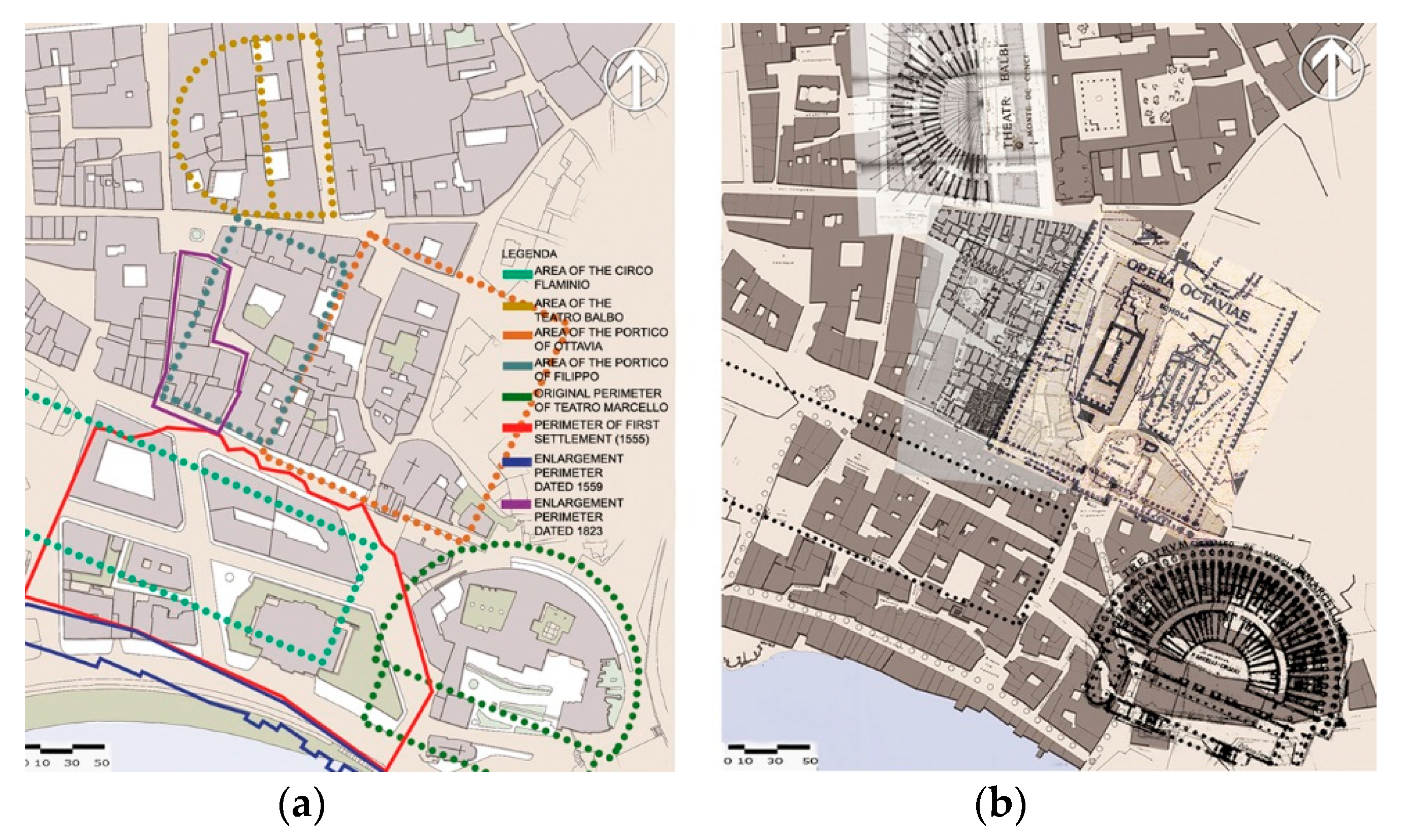
Figure 4.
Areas of archaeological interest upstream of Via Portico di Octavia. Clockwise: (a) plan of the area; (b) ground floor survey of the buildings along Via Tribuna in Campitelli; (c) archaeological findings incorporated in the masonry; (d) comparison with current pictures, and (e) with pictures dated 1980.

Figure 5.
From left: (a) Casa dei Fabii: A = alignment with Portico of Filippo; B = Roman walls; C: Casa dei Fabi; D = Roman ruins; E = ruins of S. Ambrogio church; F = ruins; (b) Casa dei Fabi: A = medieval buildings; B = ancient streets; C = Casa dei Fabi. Note: elaboration of drawing by University La Sapienza, Rome, Course Monument Restoration, prof. Fancelli.
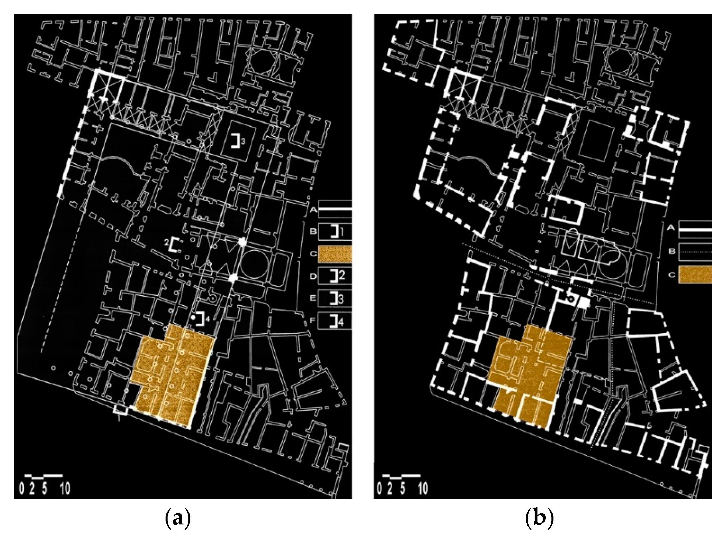
Figure 6.
Detail of the front along via Del Portico di Octavia, Casa Manili building, photographic elaboration (a); the archeological fragments in the facade (b).
Figure 6.
Detail of the front along via Del Portico di Octavia, Casa Manili building, photographic elaboration (a); the archeological fragments in the facade (b).

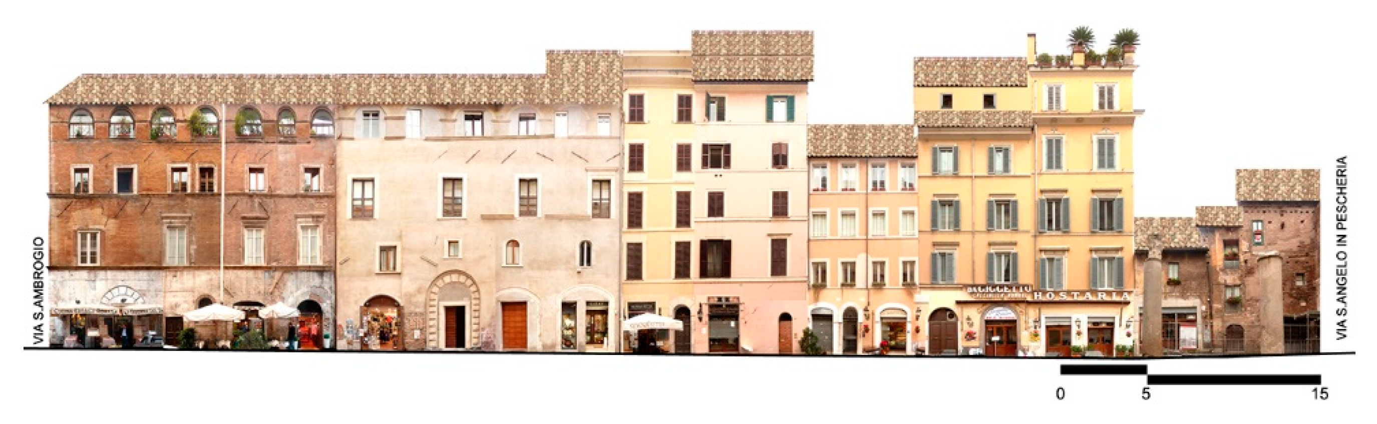
Figure 7.
Via Del Portico di Ottavia, front via S. Angelo in Peschiera—via S. Ambrogio. Second building on the left: Casa dei Fabii. First building on the right: the Casatorre dei Grassi.
Figure 7.
Via Del Portico di Ottavia, front via S. Angelo in Peschiera—via S. Ambrogio. Second building on the left: Casa dei Fabii. First building on the right: the Casatorre dei Grassi.

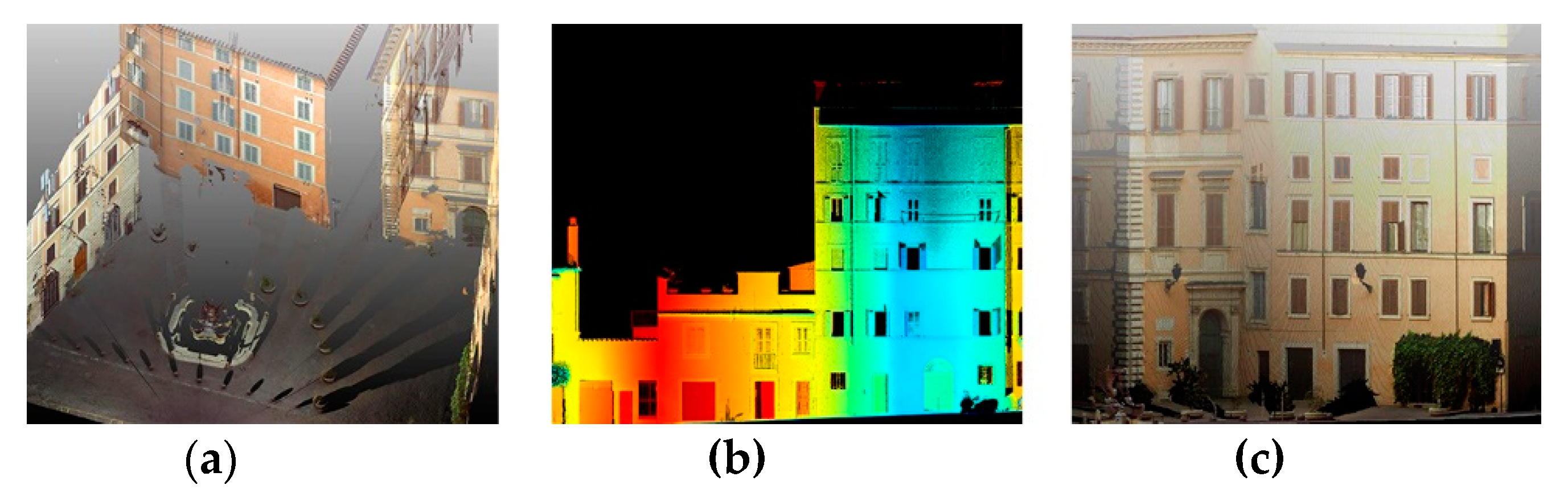
Figure 8.
Laser scanning: drafts of the point cloud (a) overview; (b) detail of via S. Ambrogio buildings, and (c) detail of piazza Mattei buildings.
Figure 8.
Laser scanning: drafts of the point cloud (a) overview; (b) detail of via S. Ambrogio buildings, and (c) detail of piazza Mattei buildings.

Figure 9.
Color survey. One of the cards.
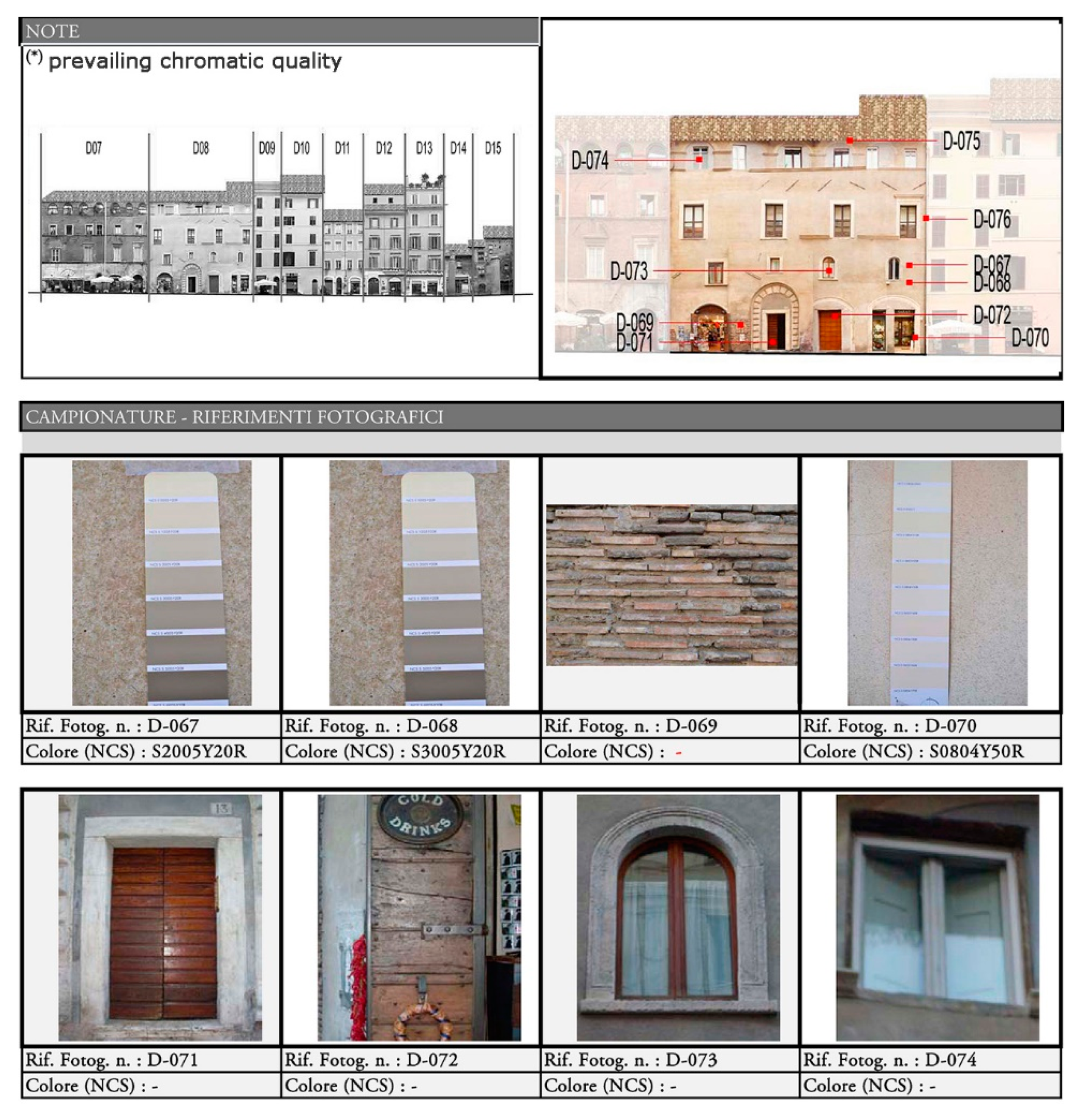
Figure 10.
Digital reconstruction (XVII). Clockwise: (a) the site, it is possible to see the buildings on the bank of the Tiber; (b) view west to east: note the first gate (1555) in Piazza Giudia; (c) view north-west to south-east, already visible the main architectural references, such as the Marcello theater; (d), (f) the Cinque Scole building, most important religious building of the ancient Ghetto, and (e) view north-west to south-east, the side of the river.
© 2019 by the author. Licensee MDPI, Basel, Switzerland. This article is an open access article distributed under the terms and conditions of the Creative Commons Attribution (CC BY) license (http://creativecommons.org/licenses/by/4.0/).
Share and Cite
MDPI and ACS Style
Cennamo, G.M. Archeological Heritage in the Area of the Jewish Ghetto in Rome: Surveying and Reading Among Archetypes and Memories of the Past. Heritage 2019, 2, 1499-1508. https://0-doi-org.brum.beds.ac.uk/10.3390/heritage2020094
AMA Style
Cennamo GM. Archeological Heritage in the Area of the Jewish Ghetto in Rome: Surveying and Reading Among Archetypes and Memories of the Past. Heritage. 2019; 2(2):1499-1508. https://0-doi-org.brum.beds.ac.uk/10.3390/heritage2020094
Chicago/Turabian StyleCennamo, Gerardo Maria. 2019. "Archeological Heritage in the Area of the Jewish Ghetto in Rome: Surveying and Reading Among Archetypes and Memories of the Past" Heritage 2, no. 2: 1499-1508. https://0-doi-org.brum.beds.ac.uk/10.3390/heritage2020094