Built Information Modeling for the 3D Reconstruction of Modern Railway Stations


Department of History, Representation and Restoration of Architecture, Sapienza University of Rome, Via del Castro Laurenziano, 7/a, 00161 Rome, Italy
*
Author to whom correspondence should be addressed.
Heritage 2019, 2(3), 2298-2310; https://0-doi-org.brum.beds.ac.uk/10.3390/heritage2030141
Submission received: 28 June 2019
/
Revised: 23 July 2019
/
Accepted: 2 August 2019
/
Published: 6 August 2019
(This article belongs to the Special Issue Heritage Building Information Modeling (HBIM))
Abstract
:The BIM process applied to the built environment represents a much debated topic in the last decade, but it still contains unanswered questions. National and international frameworks introduced standards mainly focused on the levels of detail definition related to new project, leaving a wide interpretation on the 3D reconstruction of existing building. On the other hand, the increase in the use of this modeling approach and the possible expansion of this application in the nearly future lead to predict a significant rise in built field, requiring a general assessment both on global methodology and on its peculiarities. Starting from the complete description and analysis of two modern railway architectures, based on integrated survey, 2D representation up to 3D modeling in BIM environments, the article tries to highlight the limits in the 3D BIM modeling applied on existing construction, suggesting possible solutions in relation with the obtained results. The process is critically evaluated in each passage, in order to focus the BIM research areas useful for built environment analysis.
1. Introduction
The BIM process applied for modeling, representing, and managing built artifacts is a subject that has been debated for a decade in different scientific and disciplinary fields, providing answers functional to solve specific problems. However, the topic is very wide, still presenting many domains which should be investigated in order to give more answers after a critical analysis. Indeed, on the one hand, the potentiality of HBIM has led to different declinations into specific application areas, such as ArcheoBIM, ARBIM, GeoBIM, SeismicBIM, and InfraBIM, which has led to develop methodologies devoted to solving some investigation aspects. On the other hand, however, this sectorization has moved away from a broader view, preventing to understand the general advantages and limitations of this modeling approach.
The study about the working-flow origin and its supporting tools become essential to understand the functional logic and bottlenecks of the process. First, it is important to remark that BIM can express its full potentiality in the project of new buildings, a reason why many of the international standards do not deal with the problem of construction. BIM applied to built artifact often requires compromise solutions within the process of generating complex three-dimensional geometric shapes, using iconic or simplified elements. Besides, the knowledge about wall or floor layers must be considered as well, in order to exploit the methodology for knowledge management.
The aim of the article, in addition to some critical evaluations on the methodology applied for modeling existing buildings (Built Information Modeling), is to show an analysis path on two different existing case studies related to modern architecture, in order to verify pros and cons already expressed. In particular, the main theme is to verify, through an experimental path applied to historic buildings, the problems in the application of BIM, analyzing some limits with respect to its application on new buildings in a research context defined by temporal constraint.
The definition of the case studies is framed inside a research project between Rome Sapienza University and the Emilia-Romagna Railway Company (FER), defining the survey and modeling activities of two railway buildings, “Modena Piccola” Station and Reggio Emilia “Santo Stefano” Station. These modern architectural examples have been specifically identified to highlight the bottlenecks in converting real data into a BIM model for verifying, managing, and cataloguing the consistency of the company’s assets. The methodology has been focused on direct and indirect acquisition methods (direct measuring, 3D laser scanning, close-range photogrammetry) integrated with BIM modeling approach. The first preliminary results [1] have been refined and enriched in this article with further analysis, conceiving possible answers or compromise solutions to obtain a useful result, with respect to the research purpose, while focusing on the general methodology and flexibility of the modeling and representation system.
2. Background
2.1. BIM/HBIM Birth and Expansion
The high number of experiments and research carried out in the last decade makes it difficult to define an exhaustive state of art. Certainly it is necessary to summarize the BIM and HBIM evolution in order to fully understand the meaning, advantages, and limitations of this methodology. The term BIM was coined by C. M. Eastman at the end of the 1970s, identifying for the first time a shared digital data process due to project flow [2]. However, the diffusion of this working approach occurred about ten years later, thanks to the introduction of software capable of sharing complex data systems. Through the last thirty years of methodological refinement, BIM approach represents nowadays an important project instrument, able to support the entire life cycle of a new building, from the planning to the construction, from maintenance to its dismantling.
In terms of application, five years ago some European countries, such as Great Britain and Netherlands, strongly accelerated the inclusion of this working methodology within the production cycle of building construction, in order to significantly reduce the costs of the entire process, promoting at the same time the interoperability between professionals and companies. The funding allocation at European- and national-scale, besides the growth of urban development issues related to the Green Building and Smart Cities, has promoted global resource efficiency and allows taking advantage of opportunities related to digital transformation, also enhanced by the integration and management of digital data through mobile devices [3]. In the last decade, these factors have significantly broadened the audience of BIM users inside the architecture and engineering studios, strengthening the relationship between project and representation of the idea [4] as well as the semantic aspects [5,6] or shapes ontology of buildings construction [7]. This strong connection with the world of work has obliged to introduce regulation guidelines. United States has been the first country applying such procedures, followed by the introduction of an ISO 29481-1:2010 standard based on the digitization of building information and the use of BIM [8]. At European-level, Directive 2014/24/EU has introduced some addresses on the use of the BIM system in public works projects and construction, which was accepted in a different way by the members of the Union. In Italy, it has been introduced in 2016 and standardized in 2017 with UNI 11337 [9].
In this international context, the term Historic Building Information Modeling (HBIM) [10] was coined for the first time in 2009, referring precisely to the application of this methodology for the construction, representation and management of existing buildings. This new approach has opened several questions during the last decade, highlighting great opportunities and bottlenecks related to the construction itself, its history and evolution over time [11]. The close connection between geometric knowledge of the artifacts and the relative 3D model led to a strong interdependence between HBIM and survey methodologies [12], highlighting the relationship between the accuracy of the geometric survey methodology and the reliability of its restitution [13]. These aspects have been stressed even more with the introduction of 3D active and passive techniques in the process (Dore, Murphy, 2012), showing, on one hand, the limited connection between different graphic formats, and, on the other hand, denouncing the first important HBIM restriction in the representation of complex forms, up to the “as-built” model [14]. In such sense, several researches have introduced point clouds segmentation and semiautomatic [15] or automatic extraction [16] of break lines, reducing time in data extraction, cloud management, and main feature definition of the building. Besides, the comparison between an accurate dense point cloud and a simplified 3D model is still central in the whole process. This analysis has been suggested by several authors within the process [17], highlighting the methodological need to introduce a passage of dimensional verification between the surveyed model and the reconstructed one, in order to declare the executed simplification level. The various experiments have also shown that it is almost impossible to define very complex shapes within BIM platforms, unless considering methodological variations that involve the use of traditional 3D modeling approach. This limit is mainly evident in the architectural field [18] but there are significant examples in the archaeological field [19] or within the contexts of structural emergency [20,21]. The limitations of complex shape modeling are today an unresolved problem at the global level, often translating 3D surveyed data in simplified shapes integrated with detailed documentary information, which somehow balances this platform constraint [22]. Alongside this, a second aspect concerns the difficulty in accessing the internal data of walls and floors of the building; the knowledge limitation to the building external skin leads to several lacks in the global BIM models, preventing essential information for the model understating and management.
2.2. LOD Developments
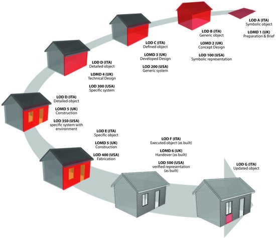
BIM methodology foresees a gradual definition of the 3D models, in relation with geometrical refinement and data content. It is set by levels of detail [23], which in some countries coincide with the levels of 3D model detail (Level of Detail (LOD)) and in others with the levels of information (Level of Information (LOI)) transmitted where graphical data are missed, suggesting a different relationship between model and real object, generically indicating as LOXs. All these hierarchies provide the 3D model which most closely approximates the real object, defining it as “built” [24]. In such sense can be interesting to compare the Italian scale in terms of “vertical” differences and similarities, according to the progression of the levels, and “horizontal” one according to the same level of detail/development, with the most known LOD scales in the world: USA and UK (Figure 1).
In USA, the concept of LOD was introduced for the first time in 2008, being adopted by the AIA National Documents Committee as “Level of Development” (AIA, 2008). This development was initially divided into five progressively more detailed stages (from 100 to 500). In 2011, the BIMForum, starting from the indications of the LODs established by AIA, began to define the LOD Specifications, introducing at the same time a new LOD level (LOD 350) and attributing for the first time the non-graphic attributes to the geometric specifications. In the end, in 2013, the meaning of Level of Development changed, on one hand, focusing on the dimensional, qualitative, and quantitative characteristics of the model in relation to its application use (E203™-2013), and on the other, dividing each level into two parts: geometric and non-geometric attributes. It is important to underline that the U.S. LOD scale refers to the individual elements/categories of elements of the BIM model and not to the level of development of the entire model (project).
In the United Kingdom, PAS 1192-2 represents the reference standard for the exchange of information in BIM projects. In 2013, the Level Of Model Definition (LOMD), defined by LOD and LOI, has been referred to the “description of the graphical and non-graphical content of the models in each step”, underlining the geometric and informative double channel (BSI, 2013). In 2015, the Technology Strategy Board developed a free digital BIM tool focused on the elaboration of LODs and LOIs related to objects and not to the project: the NBS BIM Toolkit. The LOD scale is organized according to a numbering ranging from 2 to 5: Concept stage, Developed design, Technical design, and Construction. The LOI scale foresees in addition the Operation and Maintenance step.
Finally, in the Italian context, part 4 of UNI 11337:2017 standard is devoted to the “Evolution and development of information on models, processes and objects”, providing for the introduction of “Level of development of the object” [25]. Each LOD contain geometric and informative attributes, coded according to the letters from A to G and foreseeing possible intermediate steps (e.g., LOD C.01, LOD C.02, etc.). Novelty is represented by the fact that LOD does not necessarily correspond to a certain phase of the process, instead defining the “objectives” and the “uses” of the BIM digital models. The seven LODs provide the application of the BIM approach both to new buildings and, for the first time, the built artifacts, introducing LOD F, denoting an already known system, and LOD G, denoting the updated virtualization of the actual entity in a defined time frame.
From the comparison (Figure 1) between these three systems some considerations can be deduced. First, hierarchies are generally object-oriented than design-oriented, more focused on the level of object refinement at a geometric and informative level than on the global project cycle. This latter aspect sometimes obliges to introduce sublevels in order to adapt work variations. Moreover, these levels were created following the logical and semantic refinement of the project up to its realization, but for existing objects the geometrical knowledge represents the starting point, introducing the reliability construction limits with respect to the built complexity. A problem may arise from the assumption that it is possible to reach a level of equivalence—in terms of knowledge—between existing heritage sites with respect to any newly designed artifact. In this sense it would be desirable, as already addressed by the scientific community, to distinguish the concept of “as-built” from “as-is”, in order to provide as much information as possible—external and internal—to allow proper BIM management, thus revealing both the level of knowledge and information gaps. If this is not possible, it would be appropriate to foresee and declare a certain level of simplification at both geometric and informative level, simplifying the enrichment and updating the existing information in the direction of a knowledge that is refined in an iterative way over time. In such sense some authors have worked introducing the 3D model reliability, based on the reconstruction data [26], suggesting Level of Reliability (LOR) or Level of Accuracy (LOA). In general, it could be considered desirable to provide examples that can lead professionals through the adoption of appropriate and precise protocols. In the field of architecture representation, for example, the simplification of graphic and informative contents is strongly connected to the scale of representation, therefore the inferences between the different scales of representation and LODs could be decisive, in order to ensure a greater understanding not only of the content but also in compliance with the purpose of communication and the level of detail of the project.
3. Case Studies
The buildings examined present different characteristics in terms of constructive and geometrical aspects, both pertaining to the period of modern architecture. The first is a fine railway architectural example from the early twentieth century, the second a railway building belonging to the current building.
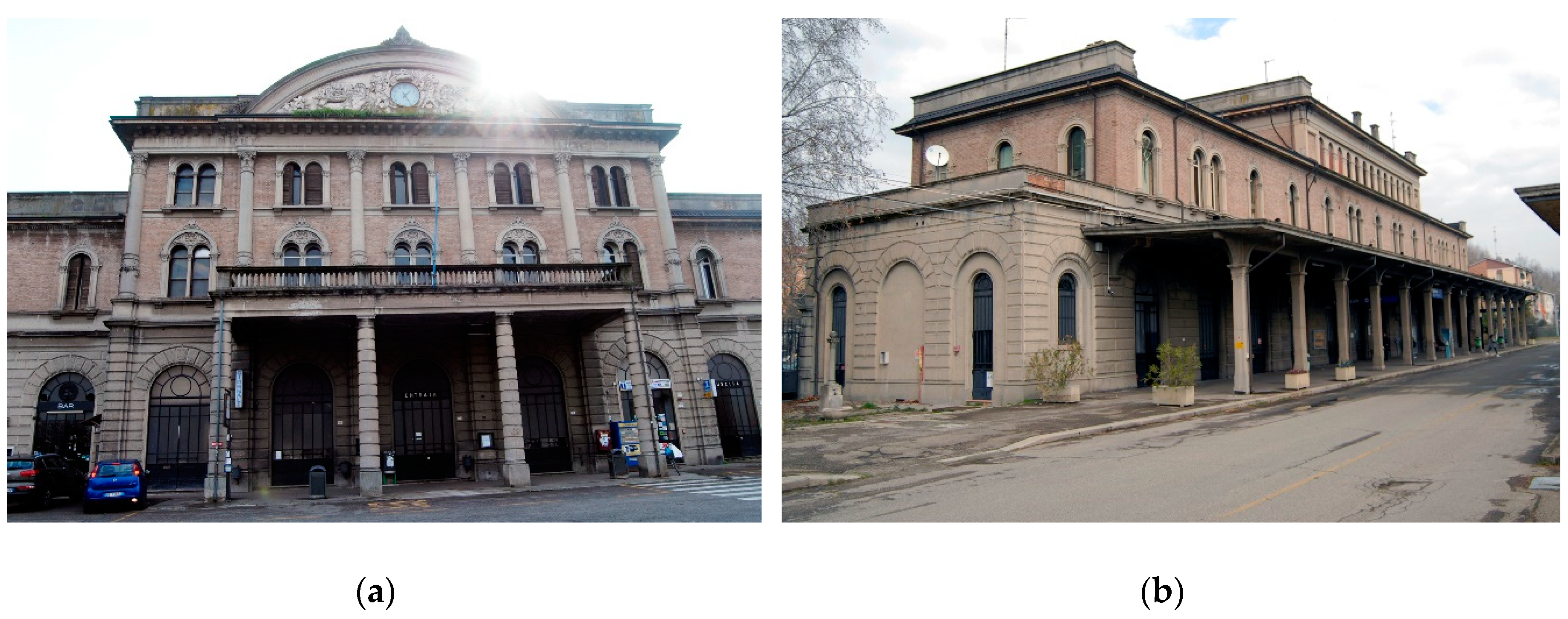
The Modena “Piazza Manzoni” Station (Figure 2), composed by the passenger and service buildings, was inaugurated in 1932 and was designed by engineer Renzo Bertolani in an eclectic language, based on the tried and tested stylistic elements of railway architecture. The architecture is characterized by Corinthian pilasters and a curved pediment in bas-relief, but also modern technologies used in the ornamental parts with decorative concrete and in the structural skeleton relating to the shelters. The shelter waiting of the first track dates to the original system, with the only variant of the raised sidewalks, made of a self-locking floor. Shelters serving the second and third tracks have also remained unchanged, apart from the increase in the height of the pavements. The passenger building, which refers to the aesthetic models of the railway stations dated between the second half of the nineteenth century and the first decades of the twentieth, showing the special attention given to the functional architectural of that time. Named “small station” to distinguish it from the main railway station of the Emilian city, it assumed a central role until 1964, when the main connections with the station were gradually closed. After a transitional period in which the station was used as bus lines transit, since 2004 the station has lost its terminal role, becoming a simple transit station and intersection as well as train depot and repair.
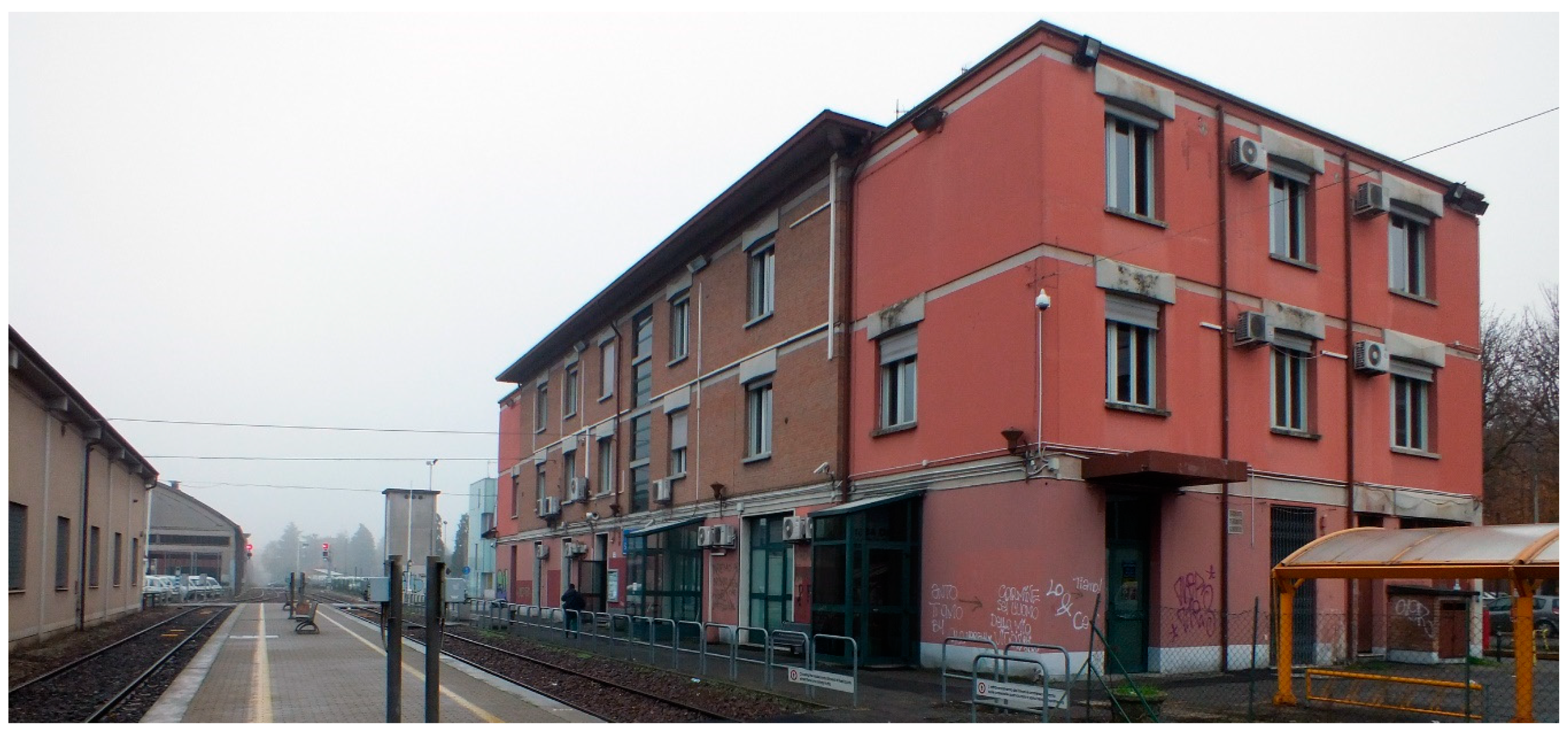
The “Santo Stefano” passenger building in Reggio Emilia (Figure 3) was completely renovated in 1955 based on a previous railway artifact built in 1907 for the construction of the Reggio Emilia Ciano d’Enza line. The reconstruction project was supervised by the technical office of the company C.C.F.R. and undersigned by the General Manager of Operations engineer Giuseppe D’Orfani. At the end of the 1970s the building was enlarged with a 2nd floor of the eastern and western fronts.
These two case studies represent, in their architectural, structural, formal, and dimensional differences, two examples of modern architecture with clear references to the styles and the transformations of the time, two aspects that represent a bottleneck when reconstructing the BIM model, therefore useful for the purposes of verification.
4. Methodology
4.1. 3D Data Acquisition
In order to achieve the research purposes, a survey planning has been defined to acquire and represent the global stations as well as their architectural, material, structural, plant engineering, and decorative elements. Consequently, the activities were planned according to different phases and levels of detail. In the survey process the integration between different methodologies has been considered, both in data acquisition, postprocessing and drawing, in order to expand the operational possibilities and the effectiveness of the results.
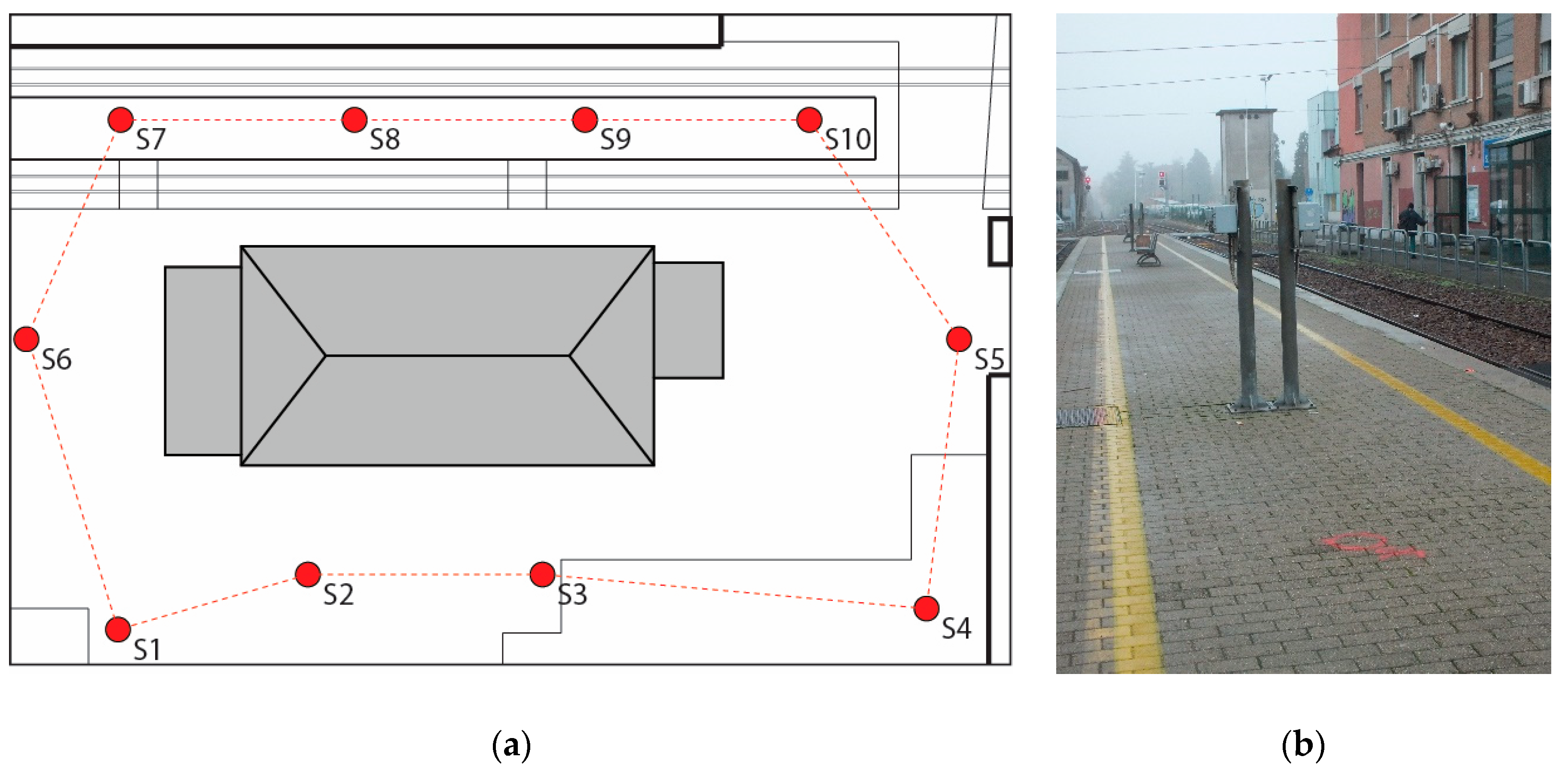
A direct survey was carried out on the buildings both outside and inside the accessible areas, acquiring basic metric dimensional data to define both the overall volume and the architectural elements; the latter are defined by a representation scale with a lower denominator. At the same time, a photographic campaign was planned, allowing appropriate insights during graphic restitution and architectural components classification. The acquired material has been ordered and catalogued in special documentary archives containing information that can be extracted, consulted and implemented over time and which is fundamental for possible calculation purposes. Besides, a 3D laser scanning campaign was planned (Figure 4a) with a phase-shift instrument (Focus3D, FARO) in order to acquire dense point clouds. The scans of Manzoni Station allowed acquiring of the external skin of the building, the ground floor, the attic of the central artifact, and the vertical distributions, while for Santo Stefano station only the external building has been surveyed. In the 3D acquisition campaign, an average GSD of about 1.5 cm on the buildings was considered suitable to optimize survey time, acquiring the main geometric information of the buildings without losing the main sculptural details. The scanning network has been materialized (Figure 4b) by fixing terrain position and recording instrumental height, to allow a posteriori verification with the total station. All scans were oriented in a single reference system using homologous artificial points and ICP algorithm for the alignment step within JRC Reconstructor software (Gexcel). For better data management, the cloud was then resampled with 2 cm of resolution (Figure 5) and managed in ReCap software (AutoDesk). In Modena example, a photogrammetric acquisition was also used to help representation of architectural details.
4.2. Modeling and Results
After closing surveying process, the two-dimensional drawing phase was started within AutoCAD software (Autodesk), exploiting the easy connection between ReCap and AutoCAD. In this step all data coming from direct and indirect survey were merged to obtain 2D documentation of the building. A unique code was assigned to each architectonic component for cataloguing purposes and simplifying logical transfer to 3D model in BIM within Revit software (AutoDesk). In this platform, a series of views consisting of axonometric cross-sections (one for each level) and two sections have been prepared, coherent with 2D drawing representations.
The aim of the 3D BIM models is to obtain digital data, which can facilitate the building management, defined by an accuracy consistent with the characteristics of the artifact, the institution delivery time of the project and the limitation in the software geometric construction. In particular, it is important to foresee a geometrical structure that allows further structural and technological analyses, while simultaneously leaving the freedom to replace simplified decorative elements with more detailed ones if required in the future.
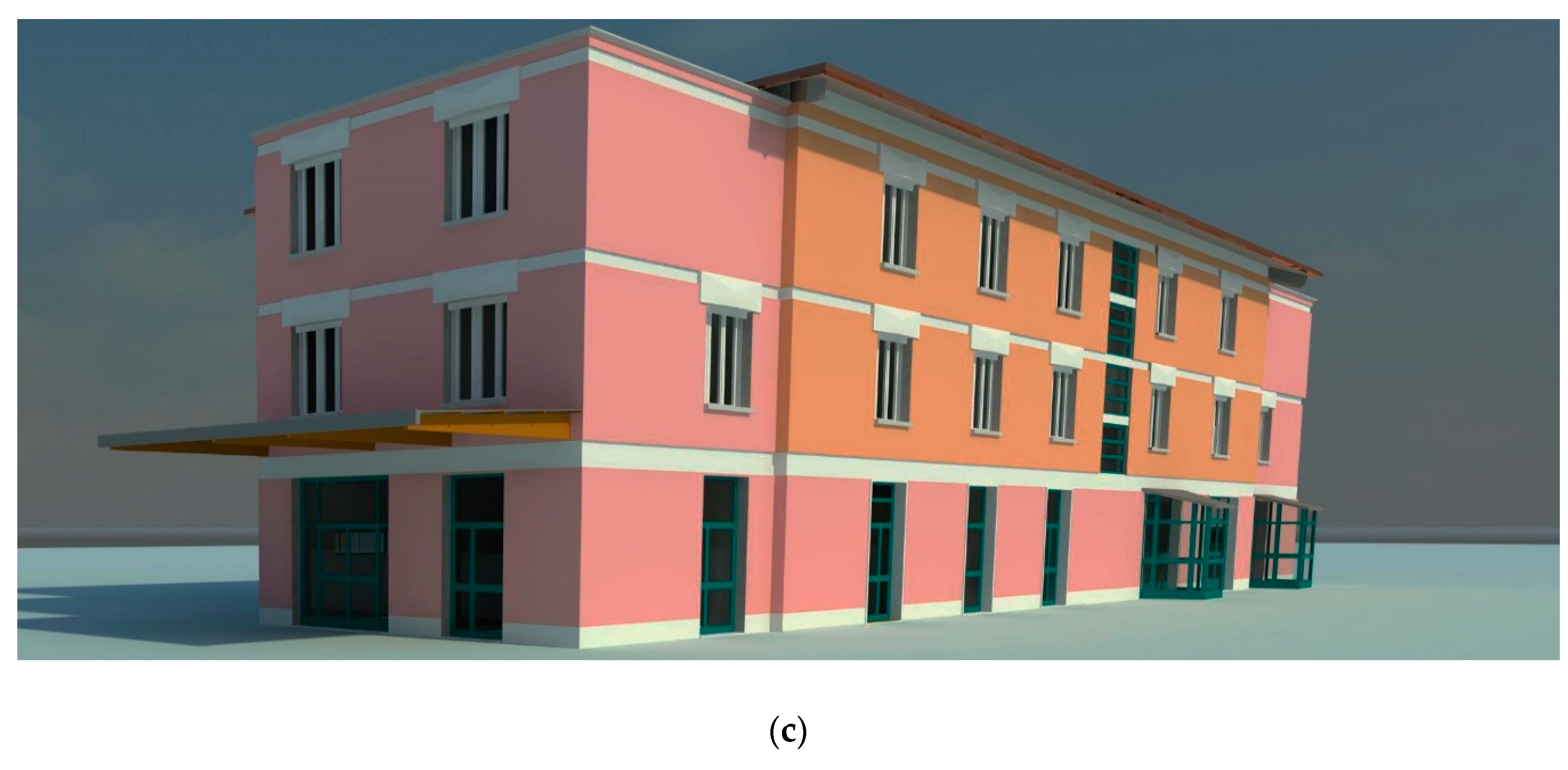
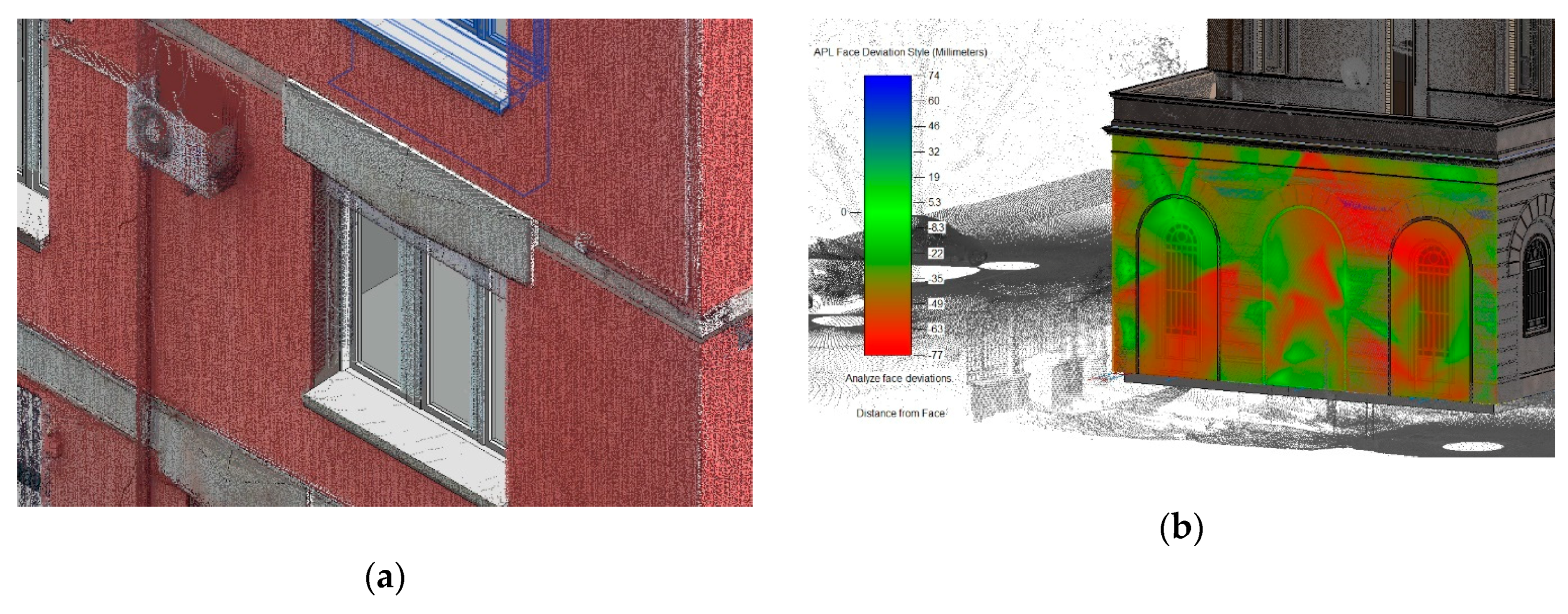
For the Modena station, the modeling step was planned to obtain graphical results between 1:100 and 1:5 scale, in accordance with assignment specifications. Then large masses referred to elevation elements and floors (Figure 6), in general entirely available in libraries, were created, obtaining an architectural apparatus of decoration exemplified in scale 1:50. Regarding decoration modeling, it is often possible to use in BIM platform parametric objects stored in a “dynamic” database, but the particular shape of architectural decoration presents in Modena station has made it necessary to model from scratch. Although the building is characterized by a stylistic feature still adherent to the early twentieth century styles, it is qualified at the same time by valuable technical elements such as prefabricated modules in reinforced litho-concrete which emulate sandstone. This material and its geometrical characteristics, punctually reported in the CAD drawing, have, unfortunately, not been properly exemplified in the BIM modeling. A similar result, in fact, has also affected the parametric processing relating to the two staircases, characterized by reinforced concrete rampant vaults of small thickness, emulating the vaulted rampant brick so-called Roman style. This specificity, which would have required an “ad hoc” and time-consuming modeling step, was simplified adopting models already existing in the BIM library in order to be subjected to project time constraints (Figure 7a,b). Similar considerations can be made about the rustication, starting from the ground floor, whose only apparent repetitiveness of the modules would have required a formulation of a specific model. The absence of documentation regarding the structural parts of the building has limited the research and representation of the model to the external skin, considering the possibility to improve knowledge at a later stage with the application of noninvasive investigation techniques such as magnetic induction analysis and thermography, which results will be poured into the BIM software. Finally, a metric comparison between the 3D virtual model and point cloud was planned within Point Layout, a Revit plugin, in order to verify the geometric model reliability, considering the shape simplification activity (Figure 8). Regarding the modeling process of Santo Stefano station, an artifact characterized by a minor complexity both in terms of stylistic features and technology, some opportunities offered by parametric modeling software can be highlighted. The representation scale of the railway station, however close to 1:50 scale considering the stylistic figure, the available executive documentation and the technological nature of the artifact, has allowed to define a complete and effective model, in relation with the client management requirements (Figure 7a,c).
The detailed elements, almost all concrete prefabricated in accordance with the stylistic code of the architecture of the post-war period, have found in the context of 1:50 representation scale an exhaustive expressiveness both in aesthetic and technological terms.
5. Discussion and Conclusions
The topic related to the application of BIM methodologies for the 3D virtual reconstruction of existing buildings has been debated for a decade, but it still contains several unanswered questions. The BIM-based tools have shown great potential in terms of data management and interoperability, at the same time highlighting significant limitations in the generation of complex shapes. The increasingly pervasive use of these modeling tools and the clear advantage in their application at the design level has led be normalized at global, European and national level, with some differences between countries mostly based on the progressive levels of information. The scares presence of topics related to built artifacts in this normative field highlights a dyscrasia between the project needs and the modeling lacks, unable to completely satisfy the 3D reconstruction complexity present in built heritage. This aspect collides with the increasing demand for BIM application in public contracts, which often requires 3D BIM models characterized for new buildings, so difficult to adapt to the existing ones. In this context, the research on two different case studies and related to railway constructions is presented, with different levels of detail and architectural features aimed at highlighting some BIM process bottlenecks.
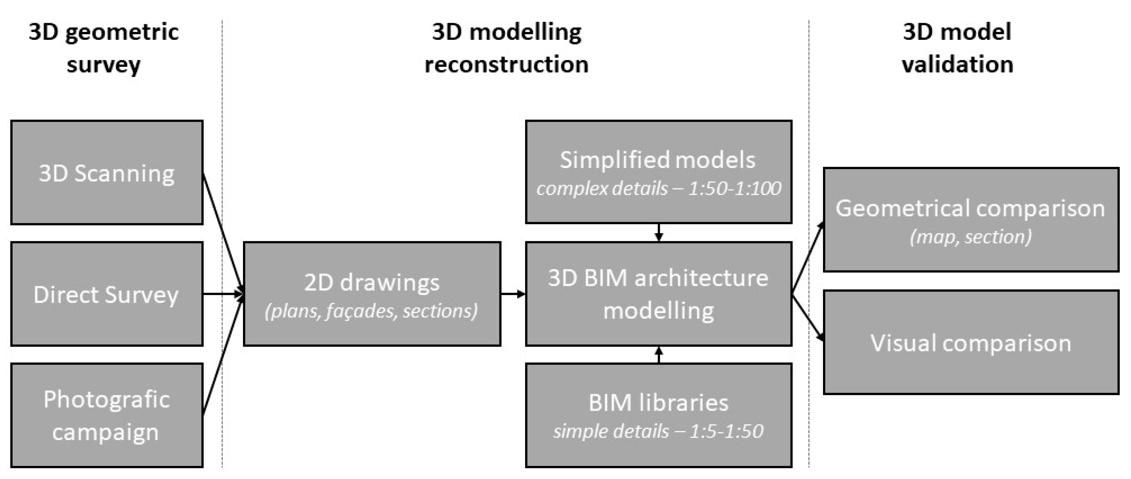
As a result of this experimentation, showed in the process pipeline (Figure 9), it is evident that the BIM-based methodology reveals clear limits in the field of executive representation scales, including efforts to parameterize architectural elements that are in fact not very standardizable, unless moving away from BIM platforms with time cost that is not always consistent with the clients’ requests. So, on one hand, the opportunities offered by BIM interoperable platforms can satisfy the general needs related to the existing artifacts, but, on the other, it is also important to converge interdisciplinary methodological approaches aimed at satisfying specific shape and function issues. Regarding the complex geometric model, which follows as closely as possible to the built reality, shared actions that can lead to interoperability between professionals can be planned in order to manage and foresee accuracy requirements of the model. These paths can lead to different possibilities: from one side the experimentation of different analysis approach using the complex geometric model, from the other the adoption of procedures that lead to a shared simplification of the complex model. At the end, “secondary” simplified models extracted from the complex one can be created by engineers and professional figures in general, in order to manage directly the simplification approach preserving the complexity of the main geometry.
We are fully aware that highlighted topics are complex and cannot be solved solely through technical solutions. Certainly, a common language based on the built elements rather than on the new projects would help in understanding issues, defining paths for the participatory solution of the problem. Experimentation has in fact highlighted the need to solve certain problems that transcend the knowledge of the architect who is called upon to use such systems. Therefore, the theme leaves several problems open as objects for future experimentation. A possible solution could refer to the representation scale, a certain architectural reference that contains a progressive level of detail. Another solution should arise from the BIM approach up to a certain scale, using different parametric modelers for representing complex forms, declaring the geometrical simplification operated respect to surveyed data. This second approach simplifies the description of more correct geometrical shapes but must be planned a longer times in advance to close the modeling project. In general, the limits highlighted, which are much more complex if referred to a historic building or even artifacts in the archaeological field, show the current existing problems in representing complex shapes within BIM platforms, a key passage for the generation of reliable 3D models consistent with the restoration or maintenance project of existing buildings.
Author Contributions
L.C. wrote the Introduction paragraph, F.L. wrote the Case Studies and Methodology sections, M.R. wrote the Background, Discussion and Conclusions sections.
Funding
The research was funded by Ferrovie Emilia Romagna for the generation of the BIM models of the two stations. The funder did not intervene on the research choices made at an experimental level.
Acknowledgments
Authors would like to thank Floriana Papa and Marcella Macera for their 3D modelling activities about the stations of Modena and Reggio Emilia respectively. They would also like to thank Gian Carlo Cundari for his help in the survey phases.
Conflicts of Interest
The authors declare no conflicts of interest. The funders had no role in the design of the study; in the collection, analyses, or interpretation of data; in the writing of the manuscript, or in the decision to publish the results.
References
- Carnevali, L.; Lanfranchi, F. Il BIM applicato al patrimonio costruito: Due casi studio. In Territories and Frontiers of Representation, Proceedings of the 39° International Conference of Representation, Naples, Italy, 14–16 September 2017; Gangemi Editore: Rome, Italy, 2017; pp. 1599–1604. [Google Scholar]
- Eastman, C.; Teicholz, P.; Sacks, R.; Liston, K. BIM Handbook. A Guide to Building Information Modeling for Owners, Managers, Designers, Engineers, and Contractors; Jonn Wiley & Sons: Hoboken, NJ, USA, 2008. [Google Scholar]
- Barazzetti, L.; Banfi, F.; Brumana, R.; Oreni, D.; Previtali, M.; Roncoroni, F. HBIM and Augmented Information: Towards a wider user community of image and range-based reconstructions. In The International Archives of the Photogrammetry, Remote Sensing and Spatial Information Sciences, Proceedings of the 25th International CIPA Symposium 2015, Taipei, Taiwan, 31 August–4 September 2015; Copernicus GmbH: Göttingen, Germany, 2015; Volume XL-5/W7, pp. 1–8. [Google Scholar]
- Osello, A.; Davardoust, S.; Semeraro, F.; Lucibello, G.; Barone, L.; Dellosta, M.; Ronzino, A.; Del Giudice, M.; Fonsati, A.; De Luca, D.; et al. The centrality of Representation with B.I.M. Disegnarecon 2016, 9, 1–12. [Google Scholar]
- Apollonio, F.I.; Gaiani, M.; Sun, Z. BIM-based modeling and data enrichment of classical architectural buildings. SCIRES-IT 2012, 2, 41–62. [Google Scholar]
- Garagnani, S. Building Information Modeling semantico e rilievi ad alta risoluzione di siti appartenenti al Patrimonio Culturale. Disegnarecon 2012, 5, 297–302. [Google Scholar]
- Oreni, D.; Brumana, R.; Georgopoulos, A.; Cuca, B. HBIM for conservation and management of built Heritage: Towards a library of vaults and wooden bean floors. In The International Archives of the Photogrammetry, Remote Sensing and Spatial Information Sciences, Proceedings of the XXIV International CIPA Symposium, Strasbourg, France, 2–6 September 2013; Copernicus GmbH: Göttingen, Germany, 2013; Volume II-5/W1, pp. 215–221. [Google Scholar]
- ISO Standard 29481-1: 2010 (E) Building Information Modelling—Information Delivery Manual—Part 1: Methodology and Format. Available online: https://www.iso.org/standard/60553.html (accessed on 27 June 2019).
- UNI (Ente Italiano di Normazione). Gestione Digitale dei Modelli Informativi Delle Costruzioni: Parti 1, 4, 5. 2017. Available online: http://store.uni.com/catalogo/index.php/home/ (accessed on 27 June 2019).
- Murphy, M.; McGovern, E.; Pavía, S. Historic building information modelling (HBIM). Struct. Surv. 2009, 27, 311–327. [Google Scholar] [CrossRef] [Green Version]
- Dore, C.; Murphy, M.; McCarthy, S.; Brechin, F.; Casidy, C.; Dirix, E. Structural Simulations and Conservation Analysis-Historic Building Information Model (HBIM). In The International Archives of the Photogrammetry, Remote Sensing and Spatial Information Sciences, Proceedings of the 3DARCH 2015, Avila, Spain, 25–27 February 2015; Copernicus GmbH: Göttingen, Germany, 2015; Volume XLII-5/W1, pp. 351–357. [Google Scholar]
- Murphy, M.; McGovern, E.; Pavia, S. Historic Building Information Modeling—Adding intelligence to laser and image-based surveys of European classical architecture. J. Photogramm. Remote Sens. 2013, 76, 89–102. [Google Scholar] [CrossRef]
- Quattrini, R.; Malinverni, E.S.; Clini, P.; Nespeca, R.; Orlietti, E. From TLS to HBIM. High quality semantically aware 3d modeling of complex architecture. In The International Archives of the Photogrammetry, Remote Sensing and Spatial Information Sciences, Proceedings of the 3DARCH 2015, Avila, Spain, 25–27 February 2015; Copernicus GmbH: Göttingen, Germany, 2015; Volume XL-5/W4, pp. 367–374. [Google Scholar]
- Hichri, N.; Stefani, C.; De Luca, L.; Veron, P. Review of the “as-built BIM” approaches. In The International Archives of the Photogrammetry, Remote Sensing and Spatial Information Sciences, Proceedings of the 3DARCH 2013, Trento, Italy, 25–26 February 2013; Copernicus GmbH: Göttingen, Germany, 2013; Volume XL-5/W1, pp. 107–112. [Google Scholar]
- Bolognesi, C.; Caffi, V. Extraction of primitives and objects from hshapes. In The International Archives of the Photogrammetry, Remote Sensing and Spatial Information Sciences, Proceedings of the 3DARCH 2019, Bergamo, Italy, 6–8 February 2019; Copernicus GmbH: Göttingen, Germany, 2019; Volume XLII-2/W9, pp. 151–156. [Google Scholar]
- Thomson, C.; Boehm, J. Automatic geometry generation from point clouds for BIM. Remote Sens. 2015, 7, 11753–11775. [Google Scholar] [CrossRef]
- Lo Turco, M.; Mattone, M.; Rinaudo, F. Metric survey and BIM technologies to record decay conditions. In The International Archives of the Photogrammetry, Remote Sensing and Spatial Information Sciences, Proceedings of the GEOMATICS & RESTORATION—Conservation of Cultural Heritage in the Digital Era, Florence, Italy, 22–24 May 2017; Copernicus GmbH: Göttingen, Germany, 2017; Volume XLII-5/W1, pp. 261–268. [Google Scholar]
- Bianchini, C.; Inglese, C.; Ippolito, A. Il contributo della Rappresentazione nel Building Information Modeling (BIM) per la gestione del costruito. Disegnarecon 2016, 9, 1–9. [Google Scholar]
- Erlacher, A.R.; Pomini, M. Utilizzo del BIM nel Campo Archeologico: I Ritrovamenti di Linea 6 Della Metropolitana di Napoli in Piazza Municipio. Bachelor’s Thesis, Politecnico di Milano, Milan, Italy, 2016. [Google Scholar]
- Oreni, D.; Brumana, R.; Della Torre, S.; Banfi, F.; Barazzetti, L.; Previtali, M. Survey turned into HBIM: The restoration and the work involved concerning the basilica di Collemaggio after the earthquake (L’Aquila). In ISPRS Annals of the Photogrammetry, Remote Sensing and Spatial Information Sciences, Proceedings of the ISPRS Technical Commission V Symposium, Riva del Garda, Italy, 23–25 June 2014; Copernicus GmbH: Göttingen, Germany, 2014; Volume II-5, pp. 267–273. [Google Scholar]
- Empler, T. Gli strumenti di rappresentazione della procedura ARBIM. In Territories and Frontiers of Representation, Proceedings of the 39° International Conference of Representation, Naples, Italy, 14–16 September 2017; Gangemi Editore: Rome, Italy, 2017; pp. 1559–1565. [Google Scholar]
- Brusaporci, S.; Maiezza, P.; Tata, A. A framework for architectural heritage HBIM semantization and development. In ISPRS Annals of the Photogrammetry, Remote Sensing and Spatial Information Sciences, Proceedings of the ISPRS TC II Mid-Term Symposium towards Photogrammetry 2020, Riva del Garda, Italy, 3–7 June 2018; Copernicus GmbH: Göttingen, Germany, 2018; Volume XLII-2, pp. 179–184. [Google Scholar]
- Bolpagni, M. The Many Faces of ‘LOD’. 2016. Available online: https://www.bimthinkspace.com/2016/07/the-many-faces-of-lod.html (accessed on 27 June 2019).
- Fai, S.; Rafeiro, J. Establishing an Appropriate Level of Detail (LoD) for a Building Information Model (BIM)-West Block, Parliament Hill, Ottawa, Canada. In ISPRS Annals of the Photogrammetry, Remote Sensing and Spatial Information Sciences, Proceedings of the ISPRS Technical Commission V Symposium, Riva del Garda, Italy, 23–25 June 2014; Copernicus GmbH: Göttingen, Germany, 2014; Volume II-5, pp. 123–130. [Google Scholar]
- INGENIOvideo, Digitalizzazione nel Settore Costruzioni: UNI11337:2017, dal Bim alla Piattaforma di Filiera. In Ecco la Norma Italiana Sulla Digitalizzazione del Settore Delle Costruzioni, la Uni 11337 del 2017. Available online: https://www.youtube.com/watch?v=IVsdCxhKDg8 (accessed on 27 June 2019).
- Bianchini, C.; Nicastro, S. La definizione del level of Reliability. Un contributo alla trasparenza dei processi di historic-BIM. Dn-Build. Inf. Model. Data Semant. 2018, 2, 45–59. [Google Scholar]
Figure 1.
Level of detail (LOD)’s progression in Italy, UK, and USA contexts with relative comparison.
Figure 1.
Level of detail (LOD)’s progression in Italy, UK, and USA contexts with relative comparison.

Figure 2.
Picture of Piazza Manzoni Station: (a) main façade and (b) secondary façade with shelter.

Figure 3.
Santo Stefano station from the platform view.

Figure 4.
Example of survey campaign in Santo Stefano Station: (a) 3D scanning schema with stations network and (b) image with stations signalized on the floor.
Figure 4.
Example of survey campaign in Santo Stefano Station: (a) 3D scanning schema with stations network and (b) image with stations signalized on the floor.

Figure 5.
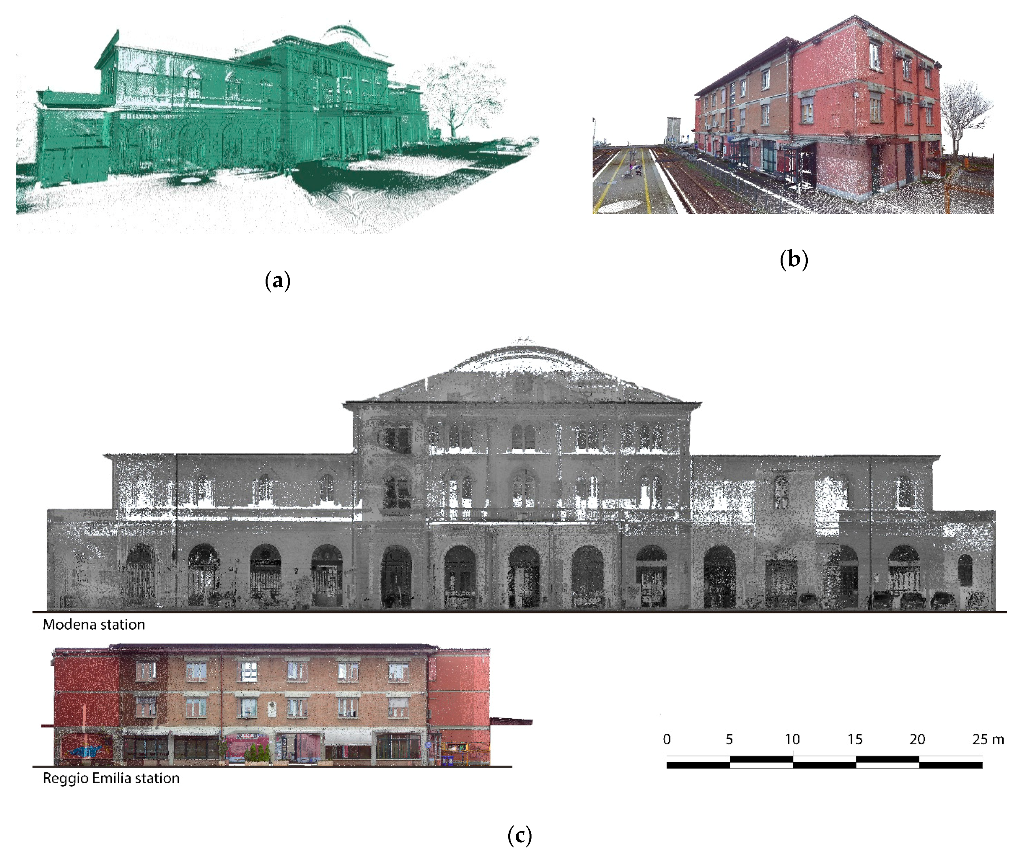
Final point cloud of the case studies obtained by 3D laser scanning: (a) Modena Piazza Manzoni Station; (b) Reggio Emilia Santo Stefano Station and (c) dimensional comparison between the orthoimages of the main façades.
Figure 5.
Final point cloud of the case studies obtained by 3D laser scanning: (a) Modena Piazza Manzoni Station; (b) Reggio Emilia Santo Stefano Station and (c) dimensional comparison between the orthoimages of the main façades.

Figure 6.
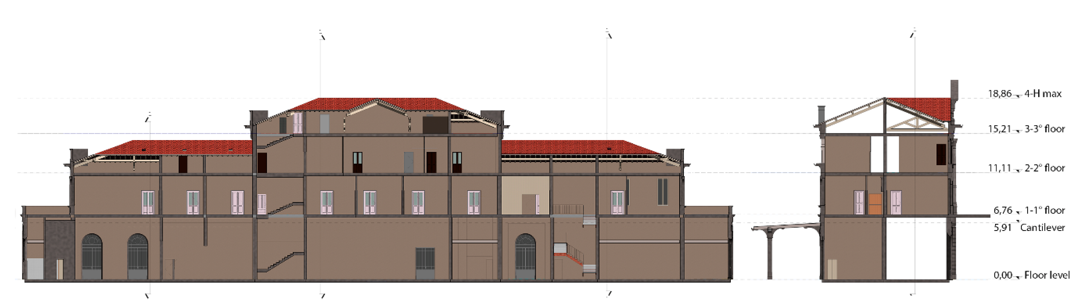
Longitudinal and transversal section of the Modena station with relative height of the floors.
Figure 6.
Longitudinal and transversal section of the Modena station with relative height of the floors.

Figure 7.
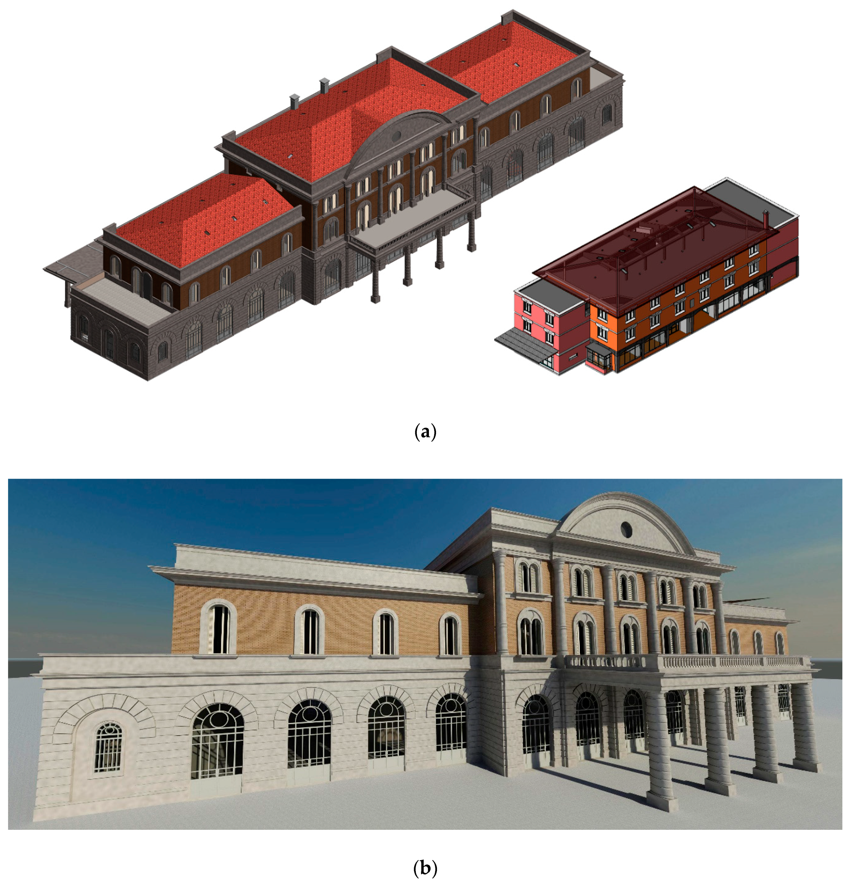
Sequence of rendering related to the BIM models: (a) axonometric view of the two models, (b) prospective view of Piazza Manzoni station, and (c) prospective view of Santo Stefano station.
Figure 7.
Sequence of rendering related to the BIM models: (a) axonometric view of the two models, (b) prospective view of Piazza Manzoni station, and (c) prospective view of Santo Stefano station.


Figure 8.
Comparison steps between 3D model and dense cloud: (a) superimposed visualization of the 3D BIM model with surveyed point cloud and (b) deviation map between the 3D model and point cloud.
Figure 8.
Comparison steps between 3D model and dense cloud: (a) superimposed visualization of the 3D BIM model with surveyed point cloud and (b) deviation map between the 3D model and point cloud.

Figure 9.
Process schema followed in order to optimize time efforts.

© 2019 by the authors. Licensee MDPI, Basel, Switzerland. This article is an open access article distributed under the terms and conditions of the Creative Commons Attribution (CC BY) license (http://creativecommons.org/licenses/by/4.0/).
Share and Cite
MDPI and ACS Style
Carnevali, L.; Lanfranchi, F.; Russo, M. Built Information Modeling for the 3D Reconstruction of Modern Railway Stations. Heritage 2019, 2, 2298-2310. https://0-doi-org.brum.beds.ac.uk/10.3390/heritage2030141
AMA Style
Carnevali L, Lanfranchi F, Russo M. Built Information Modeling for the 3D Reconstruction of Modern Railway Stations. Heritage. 2019; 2(3):2298-2310. https://0-doi-org.brum.beds.ac.uk/10.3390/heritage2030141
Chicago/Turabian StyleCarnevali, Laura, Fabio Lanfranchi, and Michele Russo. 2019. "Built Information Modeling for the 3D Reconstruction of Modern Railway Stations" Heritage 2, no. 3: 2298-2310. https://0-doi-org.brum.beds.ac.uk/10.3390/heritage2030141