1. Introduction: The MUSAS Project
The UNESCO 2001 Convention on the protection of the Underwater Cultural Heritage [
1] set new priorities in maritime archaeology, strongly emphasizing the importance of the in situ heritage protection and the need for new strategies for its enhancement; innovative projects are nowadays trying to develop shared guidelines and best practices to make easier and safer the enjoyment of cultural heritage in underwater environments, enlarging the public access and including, when it is possible, also people who cannot practice scuba-diving: a vast segment of public, hitherto excluded from the enjoyment of underwater heritage, or limited to a visit to the few dedicated museums or to the still very rare itineraries in coastal sites with transparent bottom boats.
The MUSAS Project (MUsei di Archeologia Subacquea, Tutela valorizzazione e messa in rete del Patrimonio Archeologico Subacqueo [Campania, Calabria, Puglia]), with a funding of 3,250,000 euros within the PON “Cultura e Sviluppo“ program, intends to promote the knowledge of the rich underwater archaeological heritage of southern Italy through new technologies, favoring the fruition of underwater sites and finds, even remotely and in a virtual way, guaranteeing at the same time a constant monitoring [
2,
3,
4].
For the Istituto Centrale per il Restauro (ICR—the Institute for Restoration of the Italian Ministry of Culture and Tourism—MiBACT), it is a new challenge in the field of marine archaeology, after the long experience of the ICR-NIAS, the Underwater Archaeological Interventions Unit established in Rome in 1997 and long directed by R. Petriaggi, that headed an exciting season of works on submerged sites, in Italy and abroad, in Yemen, Oman, and Libya.
The MUSAS team, led by the current NIAS director, B. Davidde, creator of the project, has been carrying out since 2017 several underwater campaigns, in addition to the implementation of a big web portal (
www.progettomusas.eu) and the execution of a large 3D survey campaign, both in the selected sites and in the museums. One of the key points of MUSAS, actually, is the creation of a Virtual Museum for the Underwater Archaeology, easily accessible by PC/Mac and mobile devices, in which the huge amount of data and images acquired in field missions can be shared; the users are now able, using their personal devices, or the totems that will be installed soon in the museums, to virtually dive in the sites, exploring the submerged ruins of Baiae, the port of Egnatia, the architectural remains on the seabed of Kaulonia; they also have access to accurate 3D models and to the virtual reconstructions of spaces and environments in their original aspects; moreover, they are able to explore a virtual gallery in which they can find the 3D models of a rich selection of underwater findings from all of the partner museums: statues and altars, amphorae and anchors, freely scalable and rotatable in order to facilitate their analysis. Within the working group, the archaeologists paid particular attention to enriching the user’s experience with detailed charts and explanations of the sites and artefacts, as well as with rich archives of materials for the needs of scholars and researchers. The biologists, on the other hand, had the task of examining the colonization of ancient structures by marine organisms, in order to provide the tools for an updated assessment of the degradation and for a planning of conservation interventions. Lastly, the aspect of environmental monitoring has been considered with the deployment in the selected sites of a network of submarine sensors, functional to the verification of different parameters, but also to the location of divers; in fact, an innovative system has been deployed that will make possible, in a very short time, diving tours with the use of tablets able to perform an augmented visualization representing the actual conditions of the ancient ruins in the underwater site and an interpretative 3D reconstruction of the archaeological remains as they appeared in the past [
5].
2. The Villa dei Pisoni
Baiae, the luxury thermal Roman resort condemned to submersion by the Phlegraean bradyseism, is a very evocative place for the Italian underwater archaeology: it was the theatre of the first underwater explorations in a submerged structure by N. Lamboglia, just after the pioneering campaigns of Albenga, and quickly became a site of excellence for the experimentation of new excavation strategies, documentation, protection, enhancement, and mainly, in situ restoration of the underwater cultural heritage [
6].
The MUSAS project is operating in two different sites within the complex of the ancient Baiae. The first one is the magnificent
nymphaeum/triclinium decorated with sculptures that was part of the palace of the Emperor Claudius, and which today lies underwater not far from the tufaceous promontory of
Punta dell’Epitaffio [
7]. The archaeologists have been working to document and to register the state of conservation of the walls and of the sumptuous coverings, but also to better understand the architectural characteristics of the monument, which was repeatedly subject to works and rearrangements during its long history before the submersion; the detailed 3D survey of the entire site has already been completed during the first season of the project, and will soon be available on the dedicated portal together with the 3D interpretative reconstruction of its features at the time of Claudius.
The second site in Baiae selected for the MUSAS Project is the gigantic Villa dei Pisoni, whose
viridarium surrounded by a portico marked by niches and half-columns is today one of the favorite destinations for a large number of divers. The villa, which takes its name from the
Calpurnii Pisones, who were responsible for a conspiracy against Nero and related to the owners of the magnificent Villa dei Papiri in Herculaneum, extends over a large area close to the
lacus Baianus, the ancient port basin today entirely submerged but once surrounded by piers and arches,
villae maritimae, and palaces [
8,
9,
10]. In this case, too, the archaeological study and the realization of 3D surveys will allow offering to the public the possibility to virtually explore a complex and stratified site, and to the archaeologists the tools for a new understanding of the articulation of the villa and of its various construction phases. Underwater researches carried on during the MUSAS Project revealed new important aspects of the architectural structure of the villa: with the help of the digital reconstruction, and thanks to the direct archaeological observation it has been possible to remark the different building phases of the complex, from the Late Republican Age to the second century AD and the time of the Emperor Hadrian; at the same time, it has been possible to point out the exceptional architectonic solutions adopted in the first nucleus of the villa on the ancient—now submerged—promontory in front of Punta Epitaffio: an impressive modification of the original landscape, with artificial piers and quays that were built directly in the sea, taking advantage of the astonishing possibilities offered by the volcanic ash of Campania, the so-called
pulvis puteolanus, in the setting of
pilae and concrete buildings in submerged or partially submerged environments [
11].
As a parallel activity, the 3D acquisition of a rich selection of artefacts from the Archaeological Museum of the Phlegraean Fields has also already been completed: more than sixty 3D models, mostly sculptures, discovered in the Gulf of Pozzuoli and rich in stories and connections with the intense life that was led in amoenis Baiis, between the villas of the most important figures of republican Rome and the sumptuous palaces of the emperors, from the Julio–Claudian dynasty onwards.
3. Source-Based 3D Modeling
3.1. The Study of the Sources
The methodology described in [
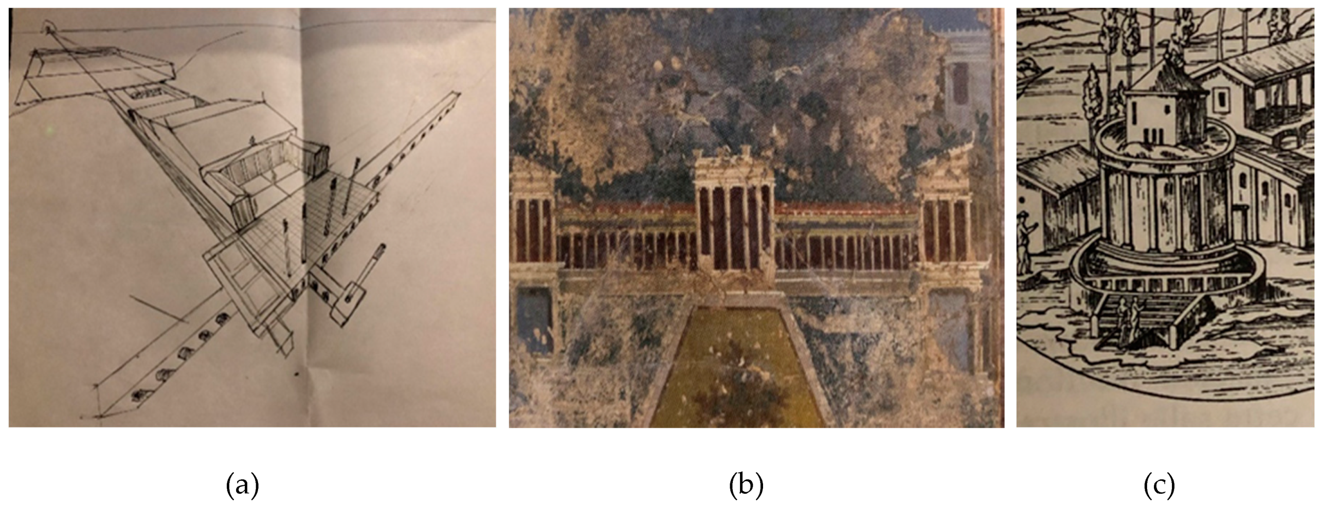
12] has been used for the creation of the digital reconstruction of the Villa dei Pisoni. The very first step of a hypothetical 3D reconstruction process is collecting and studying the sources. Scientific publications, books, archaeological maps, illustrations, photos, frescoes, vascular paintings, contemporary references and every document concerning archaeological survey and excavations, may be a precious help in defining the features of buildings and structures.
In the case of the Villa dei Pisoni, most of the material has been provided by the archaeologists. In particular, ancient paintings, mainly coming from Pompeii and from the other Vesuvian sites, already collected in several general studies on archaeology and iconography of Roman maritime villas [
13], together with some recent 3D hypothetical reconstructions and illustrations of contemporary villas (the 3D reconstruction of the Villa dei Papiri in Herculaneum by Capware, Italy [
14], the Villa Maritima of Minori, the Villa di Poppea located in Oplonti), were at the basis of various reconstruction hypotheses, especially about the dock and the seafront of the villa (
Figure 1).
3.2. Opto-Acoustic 3D Reconstruction of the Site
The digital terrain model (DTM) of the underwater archaeological site has been used as a reference for the creation of the volumetric model of the villa and the surrounding environment. This solution allowed us to set the correct scale for the project in order to achieve a very accurate 3D model.
The DTM has been obtained through a complex and articulated process that integrates optical and acoustic techniques [
15,
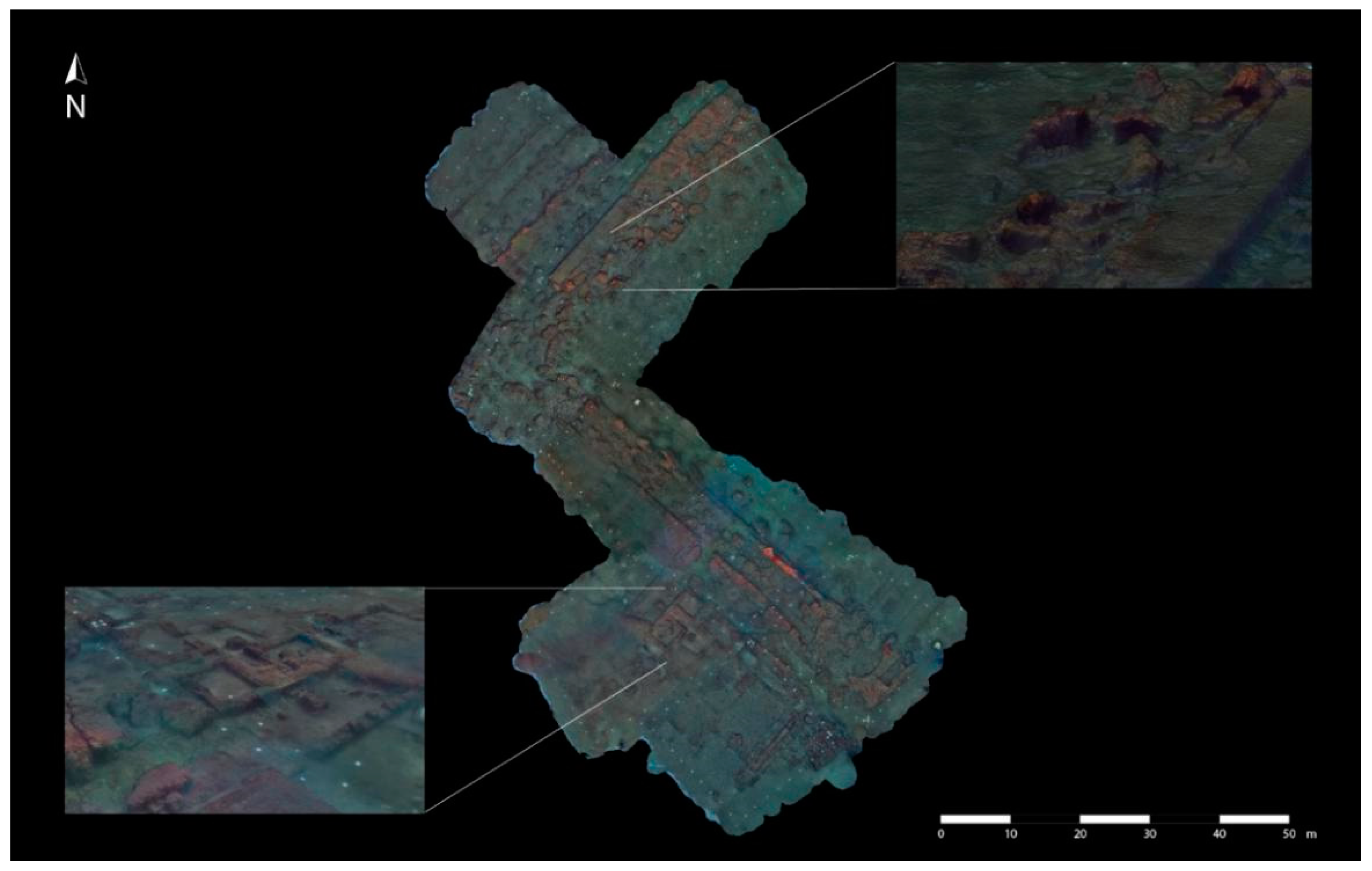
16]. In particular, high-frequency multi-beam equipment has been adopted to obtain an acoustic bathymetry of the whole submerged archaeological area, while photogrammetric techniques have been used to build a high-resolution textured 3D model of the main structures of the submerged remains of the villa. The photogrammetry allows obtaining an accurate 3D model of an object (or some architectural remains, as in this case) using photo strips, acquired so that each of them is partially overlapped to the next one. Particular software tools are able to recognize geometric features in the overlapping parts of the images, transforming them into 3D points and arranging them in the virtual 3D space. The result is a point cloud that reproduces the object’s shape and can be then transformed into a 3D surface (mesh).
In the case of the Villa dei Pisoni, the optical survey has required a complex strategy, due to the large area to be acquired (about 3600 sq. m.). It has been zoned into regular quadrants of 20 m per side and used as a reference path during the image acquisition activity. The quadrants’ perimeter was signposted by cornerstone tablets and ropes and then bordered by different waterproof markers (10 per side). These last have been also used during the reconstruction as a reference to align each quadrant to the adjacent one and to accurately compute the global scale of the 3D model. A GoPro Hero 4 silver model (GoPro, San Mateo, CA, USA), a consumer-brand high-definition sport camera with a 12MP HD CMOS sensor, 1/2.5” in size, was mounted on a rigid support and used to acquire the photo strips from a zenithal point of view, with a 70%–80% overlapping surface. After some color adjustment, the photos were transferred to the software Agisoft Metashape Pro (Agisoft LLC, St. Petersburg, Russia) [
17] to be processed. The tool recognizes the features in the overlapping images and aligns them, creating a spread 3D point cloud. Due to the huge quantity of data acquired for the Villa dei Pisoni, one single quadrant at a time was processed, creating single spread 3D point clouds, later assembled into the software using the markers as reference. In the end, the complete spread 3D point cloud was processed again to obtain a dense 3D point cloud (more defined) and finally a mesh. The final step is the texture mapping on the model, obtained in Agisoft Metashape, aligning again some of the photos used for the 3D reconstruction (
Figure 2).
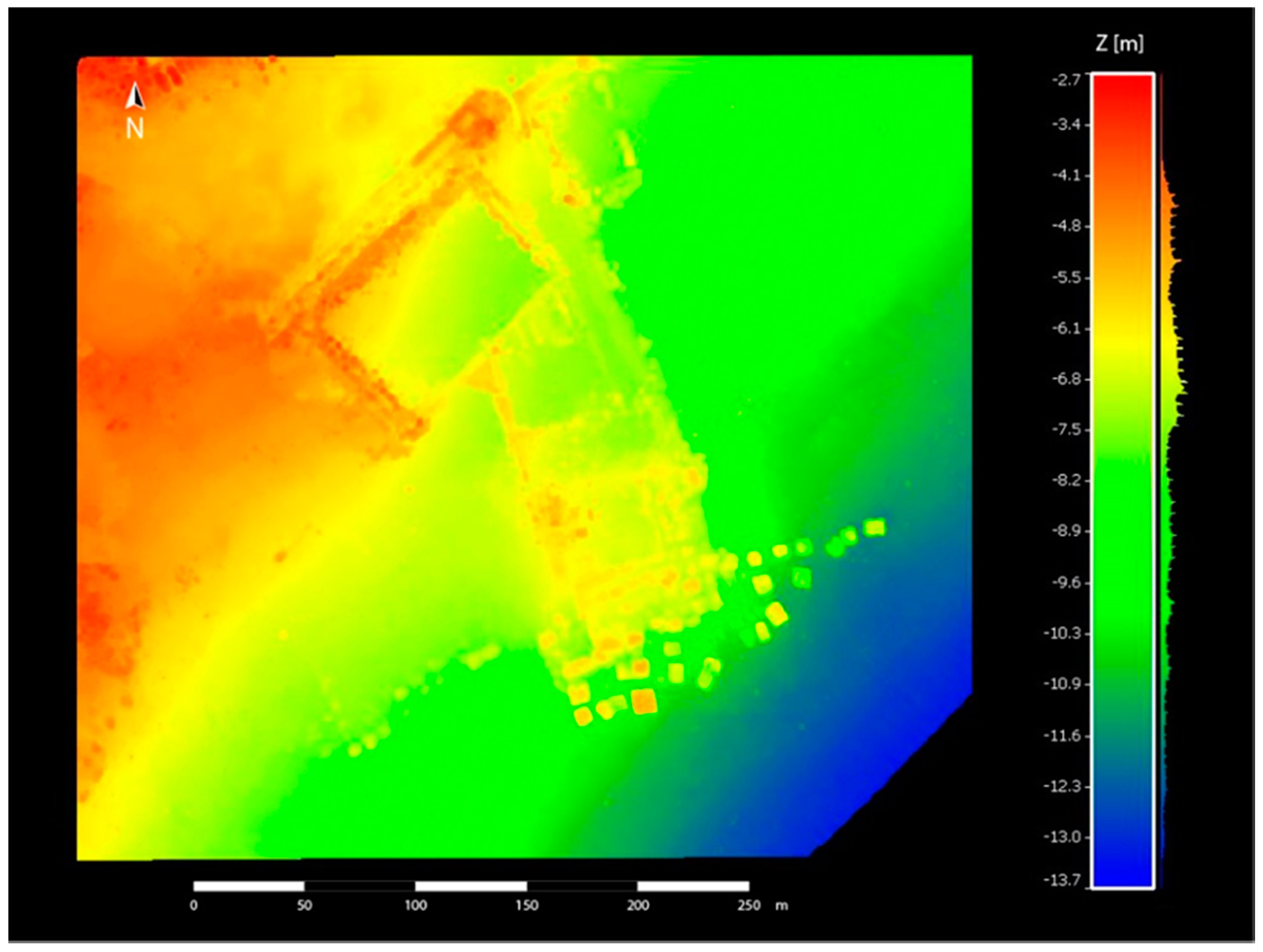
In order to complete the final scene, giving a territorial context to the villa, the whole submerged archaeological area and the neighboring area have been acquired too. In cases like this, where the area to acquire is very large and a full resolution is not necessary, the best technique to use is acoustic bathymetry, realized through small boats equipped with instruments like a high-frequency multibeam echosounder.
In particular, the DTM of the underwater archaeological site has been obtained through a morpho-bathymetric survey carried out by the Institute for Coastal Marine Environment (IAMC) of the Italian National Research Council (CNR) [
15]. The DTM of the seafloor allowed us to draw the main archaeological features of the area, which also include the military complex of Portus Iulius and the ancient thermal and villa complex of Baianus Lacus. The extraction of archaeological features from DTM was achieved thanks to the use of a GIS-derived tool based on the profile curvature algorithm (
Figure 3).
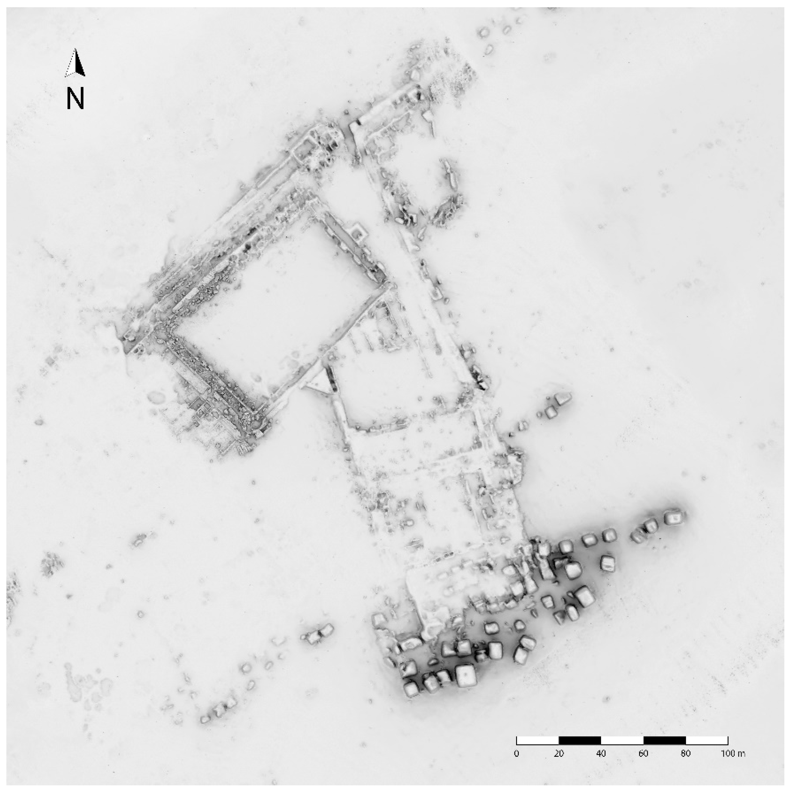
Once the survey activities ended, the optical and acoustic data have been merged by means of a target-based registration approach based on the detection of homologous geometrical entities in both 3D representations. In particular, the location of the optical 3D model on the acoustic map has been performed thanks to the geolocation of 20 ground control points (GCPs) belonging to the optical 3D reconstruction. For each GCP, 10 measurements were taken and a median of the points has been performed in order to minimize the errors of the GPS instrument. An affine transformation between the optical and acoustic data has been used to define a quantitative error metric. In particular, the mean distance has been used as an accuracy parameter. An average error of about 36 cm has been obtained.
About the merging of the two different representations, the operation has been performed by means of a selective fitting of the acoustic mesh along the contours shared with the optical mesh. The result is a polygonal multi-resolution mesh on which some manual refinements have been performed in order to correct geometry errors due to the complexity of the reconstructed scenario (
Figure 4).
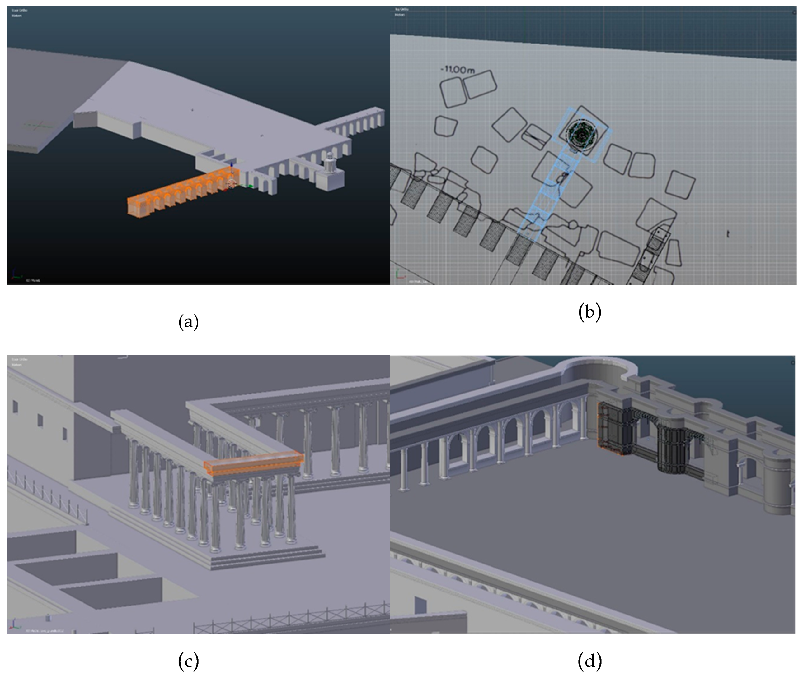
3.3. Building the Architectural Model of the Villa
Keeping the multi-resolution 3D model as a reference, the first step of the virtual reconstruction process was building the main structures: the dock with the fishponds and the lighthouse at the end, the monumental entrance in the shape suggested by the archaeologists, the perimeter of the garden, the warehouse and the viridarium.
A modular approach has been chosen to build the villa’s different sectors. In the previous experience of a 3D reconstruction hypothesis of a Roman villa [
12], all the main walls were built at once, starting from the archaeological map. In the beginning, this technique made simpler and faster the building process but, during the texturing phase, it proved to be difficult to manage and not optimized for the game engines that were used to render the virtual scenario. To solve these inconveniences, the main blocks of the villa were built as independent objects. In spite of this approach initially requiring a more accurate study of the archaeological map and more time to set the work, it allowed us to obtain a more detailed texture mapping and a lighter and faster final model.
The digital reconstruction started from the dock. It was built referring to the position of the numerous stone blocks located on the sea bottom: four long arms propending toward the sea and connecting on the other side to a large terrace, all supported by arches.
In the archaeologists’ opinion, at the end of the central dock, there could have been a lighthouse. Its shape was built referring to some of Pompei’s frescoes: a circular tambour bordered by half columns with Tuscan order capitals, supporting a beacon of smaller columns.
The seafront entrance of the villa, looking out on the big dock’s terrace, must have been monumental, as many contemporary references suggest. That is why it was designed as a tall triporticus, open towards the sea and composed by thin Ionic columns supporting a decorated architrave and the roof. However, this reconstruction is only a hypothesis that could be confirmed or modified by the results of further studies and archaeological excavations.
Based on the example of the most part of Roman villas, the archaeologists hypothesized that a peristyle with a garden was located at the back of the seafront residential block, followed by a large warehouse for the storage of supplies (
Figure 5).
As it appears from looking at the submerged remains of the villa, the
viridarium must have been a large square space, a garden, surrounded by a partially open
quadriporticus. On two sides, this last seems to be composed by alternate square and semicircular niches; on the other two sides, one presented half-columns leaning to the wall and opened towards the garden with large arches, the other one a portico with marble columns [
9]. This sector is still to be studied further and its design may be reassessed in the light of new observations.
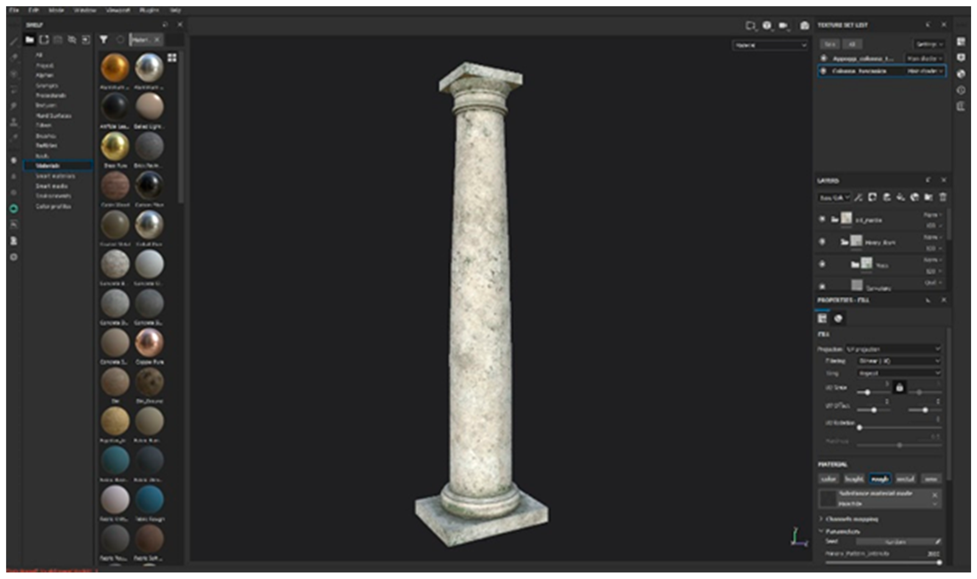
3.3.1. Texturing of the 3D Model
For the texturing phase, a new tool has been used, Substance Painter (Adobe Incorporated, San Jose, CA, USA) [
18]. It allows the creation of PBR (physically based rendering) textures, that is, textures able to react to the light in a physically correct way in order to obtain more accurate and realistic results. The software, thanks to the use of the “layer concept”, allows us to simulate the material’s wear, the dust, the moss, and so on, contributing to give realism to the final scene.
The modular modeling technique that has been used to build the different sectors of the Villa dei Pisoni has made the creation of the objects’ UV maps simpler to manage and it gave more accurate results (
Figure 6).
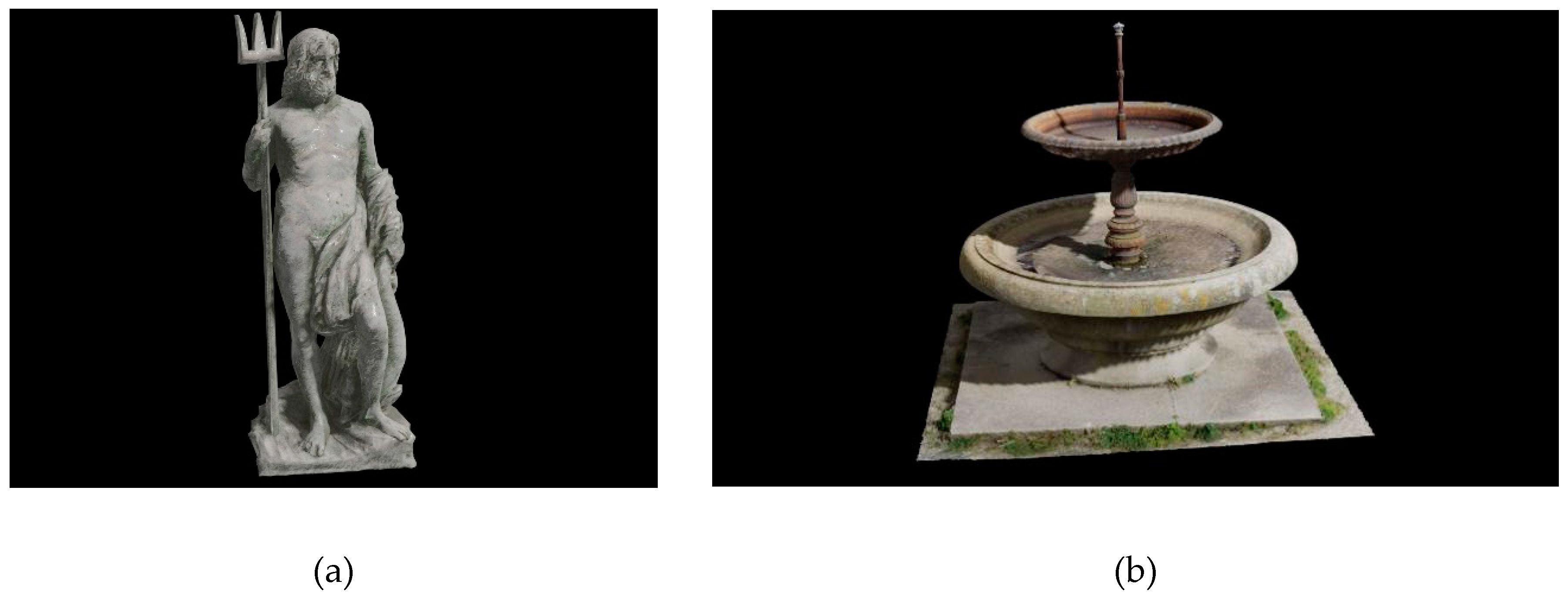
3.3.2. Modelling the Assets
A series of digital 3D objects has been placed into the virtual reconstruction to obtain a more realistic scenario: sacks, barrels, carts, step ladders, cranes, fishing nets, ropes, small boats, ships, statues, and fountains. All the objects have been built and textured separately, sometimes creating more copies of the same object with small variations. For some of them, contemporary references have been used (especially for the crane).
Only the statues have been downloaded from the web library Quixel Megascans (Quixel, Sweden) [
19] and textured using Substance Painter after a decimation process carried out in order to allow them to be rendered in real time in the virtual scenario (
Figure 7).
4. Virtual Scenario
The game engine Unity 3D (Unity Software Inc, San Francisco, CA, USA) has been used to create the virtual scenario representing the Villa dei Pisoni and the surrounding environment.
First, the architectural model of the villa has been imported into the framework and an environmental light has been added. Then, the DTM of the terrain, obtained through the acoustic bathymetry, has been placed into the scene and manually textured by using the “terrain tool” of Unity 3D. Moreover, the coastline and the sea surface have been added to finalize the virtual scene. Some simple Roman structures have been added to the scene, to populate the coast behind the villa. The farthest coast’s silhouettes have been placed as 2D images and made more realistic by adding some atmospheric fog to give more depth to the scene. Finally, some environmental elements like rocks and vegetation have been placed along the shore and into the villa’s gardens.
All the assets previously created have been included in the virtual scenario, giving it a realistic appearance (
Figure 8).
5. Conclusions
The virtual reconstruction of the Villa dei Pisoni was an opportunity to deepen and reflect on the plan of the archaeological complex. The adopted architectural choices and the general environmental setting has been inspired by comparisons with contemporary residential complexes in the Phlegrean and Vesuvian areas, deduced from iconographic, archaeological, and literary sources, as well as from the archaeological data of the site.
An iterative methodology, based on a 3D reconstruction and modeling approach, has been adopted to support the interpretative modeling step of the archaeological site of the Villa dei Pisoni, simplifying the process of the archaeologists’ feedback on the virtual model. This solution gave a significant improvement in the complex procedure for reconstructing the archaeological structures whose remains are often very few with respect to their original shape. This allowed reaching the best virtual reconstruction solution, helping the archaeologists to better focus their reasoning through a detailed visual representation, and the technical experts to avoid misleading details in the final digital model.
We have deeply felt the responsibility to create a product that was scientifically plausible and appealing to the audience’s expectations of its spectacular appearance. In fact, in recent years, 3D reconstructions of individual monuments and entire complexes are increasingly frequent in the media and in popular texts; the public is increasingly crafty and demanding. The responsibility of those working in this field is to maintain the right balance between scientific rigor and the enjoyment of images.
Author Contributions
Conceptualization, B.D.P., M.S. and A.L.; Data curation, M.S. and R.P. (Roberto Petriaggi); Funding acquisition, B.D.P.; Investigation, B.D.P., M.S. and R.P. (Roberto Petriaggi); Methodology, B.D.P., R.P. (Roberto Petriaggi), A.L., R.P. (Raffaele Peluso) and P.D.C.; Project administration, B.D.P.; Resources, M.S. and R.P. (Roberto Petriaggi); Software, A.L., R.P. (Raffaele Peluso) and P.D.C.; Supervision, B.D.P. and R.P. (Roberto Petriaggi); Validation, B.D.P., R.P. (Roberto Petriaggi), A.L. and P.D.C.; Visualization, R.P. (Roberto Petriaggi), A.L., R.P. (Raffaele Peluso) and P.D.C.; Writing—original draft, B.D.P., M.S. and R.P. (Roberto Petriaggi); Writing—review and editing, B.D.P., M.S. and R.P. (Roberto Petriaggi). All authors have read and agreed to the published version of the manuscript.
Funding
This research was funded by PON Cultura e Sviluppo 2014-2020–Asse I–“Rafforzamento delle dotazioni culturali”, Azione 6c.1.b (Decr. AdG 18/02/2016 REP 11/16).
Acknowledgments
The authors are grateful to all partners and institution that have been cooperating in this part of the Project MUSAS: Parco Archeologico dei Campi Flegrei (Fabio Pagano, Paolo Giulierini, Filippo Demma, Enrico Gallocchio, Luciano Muratgia, Salvatore Carandente), Ufficio Locale Marittimo di Baia, Ufficio Circondariale Marittimo di Pozzuoli, Carabinieri Subacquei–Nucleo di Napoli.
Conflicts of Interest
The authors declare no conflict of interest.
References
- The UNESCO Convention on the Protection of the Underwater Cultural Heritage. Available online: http://www.unesco.org/new/en/culture/themes/underwater-cultural-heritage/2001-convention/ (accessed on 21 June 2020).
- Davidde Petriaggi, B.; Stefanile, M.; D’Agostino, M.; Sacco Perasso, C.; Ricci, S. MUSAS: An innovative project for the enhancement of the Underwater Cultural Heritage. In Proceedings of the International Conference in Management of Accessible Underwater, Cultural and Natural Heritage Sites: “Dive in Blue Growth”, Athens, Greece, 16–18 October 2019; pp. 169–179. [Google Scholar]
- Davidde Petriaggi, B.; D’Agostino, M.; Stefanile, M. Tra conoscenza, valorizzazione e nuove tecnologie: Il progetto MUSAS. Forma Urbis 2019, 24, 30–35. [Google Scholar]
- Davidde Petriaggi, B.; D’Agostino, M.; Sacco Perasso, C.; Stefanile, M. The MUSAS Project: Monitoring and enhancing underwater cultural heritage in Campania, Puglia and Calabria. In Proceedings of the SOMA 2017 Symposium on Mediterranean Archaeology, Cadiz, Spain, 21–23 September 2017. [Google Scholar]
- Bruno, F.; Barbieri, L.; Mangeruga, M.; Cozza, M.; Lagudi, A.; Čejka, J.; Liarokapis, F.; Skarlatos, D. Underwater augmented reality for improving the diving experience in submerged archaeological sites. Ocean Eng. 2019, 190, 106–487. [Google Scholar] [CrossRef]
- Stefanile, M. Underwater Cultural Heritage, Tourism and Diving Centers. The case of Pozzuoli and Baiae (Italy). In Proceedings of the 5th International Congress on Underwater Archaeology: A Heritage for Mankind, Cartagena, Spain, 15–18 October 2014; pp. 213–224. [Google Scholar]
- Tocco Sciarelli, G. Baia. Il Ninfeo Imperiale Sommerso di Punta Epitaffio; Banca Sannitica: Benevento, Italy, 1983. [Google Scholar]
- Di Fraia, G.; Lombardo, N.; Scognamiglio, E. Contributi alla topografia di Baia sommersa. Puteoli 1988, 4, 211–299. [Google Scholar]
- Lombardo, N. Un documento epigrafico dalla Villa dei Pisoni a Baia. Archeologia Subacquea. Studi, Ricerche e Documenti I, 1st ed.; Ist. Poligrafico dello Stato: Rome, Italy, 1993; pp. 49–53. [Google Scholar]
- Scognamiglio, E. Aggiornamenti sulla topografia di Baia sommersa. Archeologia Subacquea. Studi, Ricerche e Documenti II, 2nd ed.; Ist. Poligrafico dello Stato: Rome, Italy, 1997; pp. 35–46. [Google Scholar]
- Davidde Petriaggi, B.; Stefanile, M.; Medaglia, S.; Petriaggi, R.; Lucci, F.; Gomez de Ayala, G.; Passaro, S. Nuovi dati sulle ville di Baia dalla ricerca archeologica subacquea. In Proceedings of the Conference Villae Maritimae del Mediterraneo Occidentale. Nascita, Diffusione e Trasformazione di un Modello Architettonico, Napoli, Italy, 5–9 May 2019. [Google Scholar]
- Petriaggi, B.D.; Petriaggi, R.; Bruno, F.; Lagudi, A.; Peluso, R.; Passaro, S. A digital reconstruction of the sunken “Villa con ingresso a protiro” in the underwater archaeological site of Baiae. IOP Conf. Ser. Mater. Sci. Eng. 2018, 364, 012013. [Google Scholar] [CrossRef] [Green Version]
- Lafon, X. Villa Maritima: Recherches sur les Villas Littorales de l’Italie Romaine: IIIe Siѐcle av. J.C.-IIIe Siѐcle ap. J.-C.; Ecole Francaise de Rome: Rome, Italy, 2001. [Google Scholar]
- Capware. Available online: www.capware.it (accessed on 15 October 2020).
- Bruno, F.; Lagudi, A.; Muzzupappa, M.; Lupia, M.; Cario, G.; Barbieri, L.; Passaro, S.; Saggiomo, R. Project VISAS—Virtual and augmented exploitation of Submerged Archaeological Sites: Overview and first results. Mar. Technol. Soc. J. 2016, 50, 119–129. [Google Scholar] [CrossRef]
- Lagudi, A.; Bianco, G.; Muzzupappa, M.; Bruno, F. An alignment method for the integration of underwater 3D data captured by a stereovision system and an acoustic camera. Sensors 2016, 16, 536. [Google Scholar] [CrossRef] [PubMed] [Green Version]
- Agisoft Metashape. Available online: https://www.agisoft.com/ (accessed on 1 January 2019).
- Substance Painter. Available online: https://www.substance3d.com/ (accessed on 1 March 2019).
- Quixel Megascans. Available online: https://quixel.com/megascans/ (accessed on 1 March 2019).
| Publisher’s Note: MDPI stays neutral with regard to jurisdictional claims in published maps and institutional affiliations. |
© 2020 by the authors. Licensee MDPI, Basel, Switzerland. This article is an open access article distributed under the terms and conditions of the Creative Commons Attribution (CC BY) license (http://creativecommons.org/licenses/by/4.0/).

 ,
, 


