Article

Risk and Resources: An Evaluation of the Ability of National Soil Datasets to Predict Post-Depositional Processes in Archaeological Sites and Heritage at Risk

Department of Archaeology, Dawson Building, Durham University, South Road, Durham DH1 3LE, UK
*
Author to whom correspondence should be addressed.
Submission received: 19 March 2021 / Revised: 16 April 2021 / Accepted: 21 April 2021 / Published: 8 May 2021
(This article belongs to the Section Archaeological Heritage)

Abstract

:
Previous studies have demonstrated the vast range of physical, chemical and biological processes that influence the preservation of archaeological sites, yet characterisation at the site-level remains largely unexplored. National datasets on soil type, land use and erosion modelling have the potential to predict localised impacts but remain an untapped resource in the evaluation of heritage at risk. Using early medieval Scotland as a case study, this paper explores in detail some of the primary factors which have impacted the archaeological record and the degree to which site-based evidence contained in excavation reports compares with national datasets (Land Cover Map 2015, Soil Information for Scottish Soils and Soils of Scotland Topsoil pH) and coastal erosion models (Dynamic Coast National Coastal Change Assessment and Coastal Erosion Susceptibility Model). This provides valuable information on the preservation of Scotland’s early medieval settlement, as well as a methodology for using national datasets in the remote assessment of post-depositional factors across the broader archaeological landscape. Results indicate that agriculture, bioturbation and aggressive soil conditions are among the most significant factors impacting Scotland’s archaeological remains. While the national datasets examined have the potential to inform heritage management strategies on these processes, their use is limited by a number of theoretical and methodological issues. Moving forward, site-specific studies that characterise the preservation environment will be crucial in developing baseline assessments that will advance both local and global understandings of destructive factors and soil-mediated decay.

1. Introduction

From individual dwellings to large towns and cities, the remains of settlement provide a unique insight into the social, economic, political and ideological systems that shaped societies across the world. Settlement has been found in almost all geographic and environmental contexts, but the extent to which archaeologists can access these elements varies widely, not least because preservation and post-depositional events have played (and continue to play) a significant role in altering the settlement record. The factors involved are diverse but can include physical truncation as a result of land processes (e.g., agriculture, urban development and erosion) or biological and chemical degradation in the buried environment (e.g., microbial activity and soil acidity/alkalinity). Understanding how these processes have influenced a site following its original depositional phase is crucial in creating valid interpretations of the evidence, and whilst there are multiple theoretical and methodological tools at our disposal, relatively few studies explicitly engage in an analysis of post-depositional processes.
In opening up this conversation, this paper presents a case study in Scotland to look at the quality of the information that can be gained from past excavation literature, and how national datasets may provide meaningful information on the preservation environment, post-depositional events and prospective threats to a region’s archaeological resource. To date, a handful of studies have applied national soil survey data to the archaeological record, but their focus has primarily been on site prospection [1,2,3] and similar efforts have not been extended to an assessment of heritage at risk. Risk maps offer a valuable resource for heritage management; however, recent iterations have concentrated on catastrophic threats, such as natural disasters [4,5,6], or the long-term effects of pollution, tourism, erosion or climate change [5,7,8]. By comparison, very few efforts have mapped the risk associated with buried heritage. Given that the preservation of buried archaeology is determined at the soil interface, national soil data has the potential to form the basis of heritage risk maps that focus on post-depositional processes. However, the degree to which current data corresponds with site-based evidence has not yet been established. This is the first study to qualitatively review site-based literature and national datasets in the assessment of preservation factors, and offers a methodological framework for future practice that could be adapted and applied in any country where national soil datasets are available.

2. Scotland as a Case Study

2.1. Issues with Scotland’s Early Medieval Record

Scotland’s diverse landscapes—its machair sands, heather uplands, coastal zones and rolling farmlands—contain significant evidence of its early medieval populations. The period, roughly defined as AD 300–900, sits on the precipice between history and prehistory, and whilst glimmers of insight have been gained from Roman, Irish and English texts, there are few native records or historical accounts that pre-date the twelfth century [9,10]. Archaeology has proven essential in developing our understanding of the period, and much information has been gained from the analysis of funerary monuments [11,12], fortified sites [13,14,15] and an enigmatic material culture [16,17].
However, there remain significant gaps in the knowledge that are proving difficult to overcome. Detailed information regarding daily life is almost non-existent and there are particular geographic areas, such as Argyll in the west, that have produced almost no settlement evidence for the period [18]. Moreover, there is a significant bias in favour of rural contexts. Only a very small number of early medieval structures have been found in modern suburban settings, and there is almost no evidence in modern city centres, where it is likely that later medieval and post-medieval urban development destroyed any early medieval phases [19] (p. 11).
Obliteration as a result of modern ploughing and urban development is one of the theories put forward for the general lack of early medieval settlement observed across Scotland [20]. Yet, excavation reports clearly attest to other agents, such as coastal erosion, reuse and animal activity, playing a cumulative role in the alteration and loss of archaeological detail. The extent to which post-depositional events have shaped this fragmented record remains largely unexplored and continues to limit the interpretation of site histories and wider settlement patterns. Management solutions are similarly restricted by a poor understanding of the most significant threats to the resource which, given the increasing recognition that in situ preservation is not always the most effective strategy, requires addressing [21,22]. As such, there is a clear need to explore not only the physical aspects of early medieval settlement but also the nature and agents of its survival.

2.2. Early Medieval Settlement in Scotland

Archaeological evidence of Scotland’s early medieval settlement has increased dramatically in recent decades. The record, once believed to survive largely as coastal and hilltop fortifications, has now expanded to include a range of unenclosed and enclosed settlement types spread across a variety of environmental settings. This has raised exciting new questions about political and social organisation, the relationships between different site types, and the motivations behind a shift from round to rectangular house forms—all of which currently remain unanswered [23] (p. 262). However, whilst it is now possible to identify settlement and comment on regional variations in architecture and layout [20] (pp.113–140), [24], there is little to no understanding of the roles these structures played or how their wider communities operated [23] (p. 263).
A key issue has been the generally poor preservation of settlement remains of this period. The stone-built tradition that has resulted in the survival of upstanding remains on the Western and Northern Isles (e.g., the cellular structures at Cnip, Udal, Bostadh and Old Scatness—though see [25] for commentary on the lack of analysis regarding the use of space) is not widely found across the mainland, and researchers face the distinct possibility that buildings were constructed using methods that have survived very poorly in the ground [20] (p. 140). Though structures have been reported at enclosed sites, including Clatchard Craig (Fife), Rhynie (Aberdeenshire), and the promontory forts of Burghead and Portknockie (Moray), they survived only as truncated posthole outlines and failed to produce the occupation deposits required to elucidate important information regarding their status or function [26]. Unenclosed sites have proved similarly problematic, typically consisting of single or grouped domestic structures, or more ephemeral traces such as isolated hearths and activity surfaces. Even the best-preserved examples (upstanding turf structures in the Perthshire uplands) have failed to produce clear internal deposits [27,28].
The national picture is therefore one in which we are gaining an increasing number of sites but little development in our understanding of the role or interaction between settlement types. A lack of occupation deposits, coupled with poor preservation conditions (particularly the decomposition of organic material in Scotland’s well-draining acidic soils), has restricted interpretations in both unenclosed and fortified settlements, and many aspects of early medieval society—its material culture, life ways and social economy—remain frustratingly elusive.
Part of the issue lies in the fact that we do not yet fully understand the mechanisms behind the absence of detail. In some cases, the reasons are clear: the destructive natures of agriculture, erosion and urban development have been well documented and their influence across Scotland is widely apparent [20,29]. Yet, there are other cases, particularly in upland environments, where such factors have not played a significant role. At these sites, interpretations of the evidence (or lack thereof) have typically centred around function, reuse or post-depositional truncation (e.g., [28] (p. 47)), but there has been little attempt to delve any deeper into the contributing factors. Such broad interpretations do little to address important social questions and risk creating a narrative based on preconceived notions and assumptions of the preservation environment, rather than confirmed findings.

2.3. Approaching the Issue

It has long been accepted that reliable archaeological interpretations begin with a well-preserved and well-understood assemblage [30]. The ability to ascertain patterns of deposition and states of preservation has developed greatly over the past few decades [31], yet there has been relatively little investigation into the taphonomic and post-depositional processes occurring on early medieval settlement sites across Scotland. Where exceptions do exist, they tend to be a minor part of much larger projects, and there is little understanding of how the specific aspects of settlement (e.g., building fabric, architectural style, function or longevity of use) or its environmental context (e.g., topography, soil type or biota) can influence these taphonomic signatures.
Accessing this information is the first step in addressing the absence of detail for early medieval settlement. It will permit reliable interpretations over the survival of dwellings in different contexts and aid estimations of where settlements (now lost) may once have originally stood. Equally, it will allow an understanding of patterns in the distribution, scale and severity of post-depositional processes, and an assessment of the threats that these sites face both now and in the future. This latter point is critical in ensuring that the limited cultural resource is managed effectively, and that sites most at risk of destruction (or those that currently have the best examples of preservation) are prioritised for excavation.
Given that archaeological excavation is a destructive, expensive and time-consuming venture, the ability to assess risk remotely is becoming increasingly important. Scotland has a number of national datasets and models that have the potential to provide information on the preservation environment but, to date, their use within an archaeological context has been limited and largely concentrated on coastal erosion. Examples include the Coastal Erosion Susceptibility Model (CESM), which represents the erosion susceptibility of the coastline [32], and the National Coastal Change Assessment (Dynamic Coast NCCA), which maps past shoreline changes and projects these forward to 2050 [33,34]. The NCCA identified 874 known heritage sites within potential erosion zones; however, the degree to which these models actually reflect conditions at the site-level remains largely untested. A recent small-scale case study on Sanday, Orkney, found that local-scale vegetation edge analysis (digitised from historic maps and aerial photographs) had a higher agreement with known eroding archaeological sites than either of the two national models [35].
This gap between predicted and observed data is part of a wider problem, evidenced in Historic Environment Scotland’s recent publication on the threats posed by climate change [22]. Although the document outlines the potential impacts of rainfall, temperature and extreme weather events on the nation’s cultural heritage, the majority of impacts are speculative and remain untested across much of the historic environment [22]. Without a baseline understanding of how sites have already been affected by chemical, physical and biological factors, it is impossible to assess the threat posed by future changes.
This study therefore aims to address these issues by developing a desk-based analysis of post-depositional processes. Using excavation literature, it begins by cataloguing the major processes recorded on excavated early medieval settlement sites in eastern Scotland to provide a foundational understanding of taphonomic and post-depositional events at the site-level. The study then examines whether free and publicly available datasets accurately reflect the preservation conditions identified during the excavation of these sites, and evaluates whether they can provide a viable means of remotely assessing archaeological sites in Scotland, before considering the global potential of the methodology.

3. Materials and Methods

3.1. Phase 1: Site-Based Analysis

Owing to the increasing number of early medieval sites identified across the north and east of Scotland [36], a study area stretching from Dornoch in the north, to Loch Tay in the east, and North East Fife in the south (~24,000 km2), was established (Figure 1). This area encompasses a range of different preservation environments, including heather uplands, coastal zones and arable lowlands, and was deemed a suitable case study for the evaluation of the national data in Phase 2 of the Methodology.
Sites with settlement features radiocarbon dated to the first millennium AD (spanning approximately AD 300–1000) were selected for qualitative literature review in order to catalogue the post-depositional processes impacting early medieval remains. Published and unpublished excavation reports from the last three decades were thoroughly read in order to identify a variety of preservation conditions and post-depositional processes. Longer texts were subjected to semi-automated word searches in order to identify passages with information on preservation. These search terms have been provided in Supplementary Material S1. Documents analysed included academic journal articles, data structure reports, and site-based monographs. The presence/absence of a range of observed processes was recorded in a Microsoft Excel database, alongside notes on their nature, extent and impact. Information regarding the reuse of sites was also recorded.
A total of 65 documents were analysed in order to retrieve information regarding 27 sites with evidence of early medieval settlement activity. Settlement features at each location were grouped according to the name and identification number in Scotland’s national online historic environment archive “Canmore” (canmore.org.uk).
The level of detail provided for post-depositional processes was found to vary widely depending on the nature of investigation and the type of literature available. Reports produced as a result of large-scale studies (e.g., Portmahomack and Kintore) provided the greatest detail, whilst watching briefs typically provided the least (e.g., Mither Tap). Similarly, excavations which employed specialist analysis, such as soil micromorphology, identified processes in greater detail. As such, the evidence described below should be taken as an indicator of the factors affecting early medieval settlement sites in Scotland, rather than an exhaustive catalogue. Nevertheless, a number of significant trends were identified across the literature; their occurrence at each site is summarised in Table 1 and reported in more detail in the Results section.

3.2. Phase 2: Comparison with National Data

Results from Phase 1 indicated that land use, soil acidity, erosion and bioturbation were among the primary factors impacting early medieval settlement sites. National datasets which pertained to these processes were selected for comparison with site-based observations. This included the Land Cover Map 2015 (LCM2015 [38]; available for free via the UKSO Map Viewer), the Coastal Erosion Susceptibility Model (CESM [32,39]) and the Dynamic Coast National Coastal Change Assessment [34]. In the absence of a subsoil pH map, the Soils of Scotland Topsoil pH dataset [40] was used to assess whether this acted as a suitable proxy for sediment acidity. As there is currently no national or UK-based dataset relating to soil turnover, earthworm/macrofauna density or redox conditions, an assessment of bioturbation levels or oxic/anoxic preservation conditions could not be achieved.
The soil properties reported at each site were also reviewed in order to assess whether national soil data could provide a useful means of estimating preservation environments in archaeological sites. The Soil Information for Scottish Soils (SIFSS) website is an online interactive platform that divides the country into numbered soil mapping units (QMUNITs) [41]. Each QMUNIT identifies a unique combination of parent material, landforms and component soil types, and relates this to information on soil colour, structure, drainage and chemical properties. Different soil types are categorised into taxonomic units known as ‘series’, which are grouped under an ‘association’ based on their parent material. These soil series have different drainage and chemical properties that can affect the waterlogging, leaching or acidity of archaeological deposits.
Values and information for each site were collected by importing the LCM2015, CESM and Soils of Scotland Topsoil pH datasets into QGIS 3.14.1 as shapefiles, plotting the locations of settlement evidence (using the NGRs recorded in Table 1) and extracting the data using the Point Sampling Tool plug-in. Data from the NCCA and SIFSS were both collected directly from online mapping services (Dynamic Coast and SIFSS respectively). The values for soil and land use properties are recorded in Table 2. As only two sites in the study area were located in the coastal zone, these have been recorded separately in Table 3.
The degree to which national data corresponded with the site-based observations was assessed qualitatively and ranked on a scale using the categories “Very Similar”, “Similar”, “Neutral”, “Dissimilar” and “Very Dissimilar”. Where the national datasets returned no value for the entered NGR, it was assigned the category “No Data”. A ranking criterion used to compare each of datasets was established and can be viewed in Appendix A.

4. Results

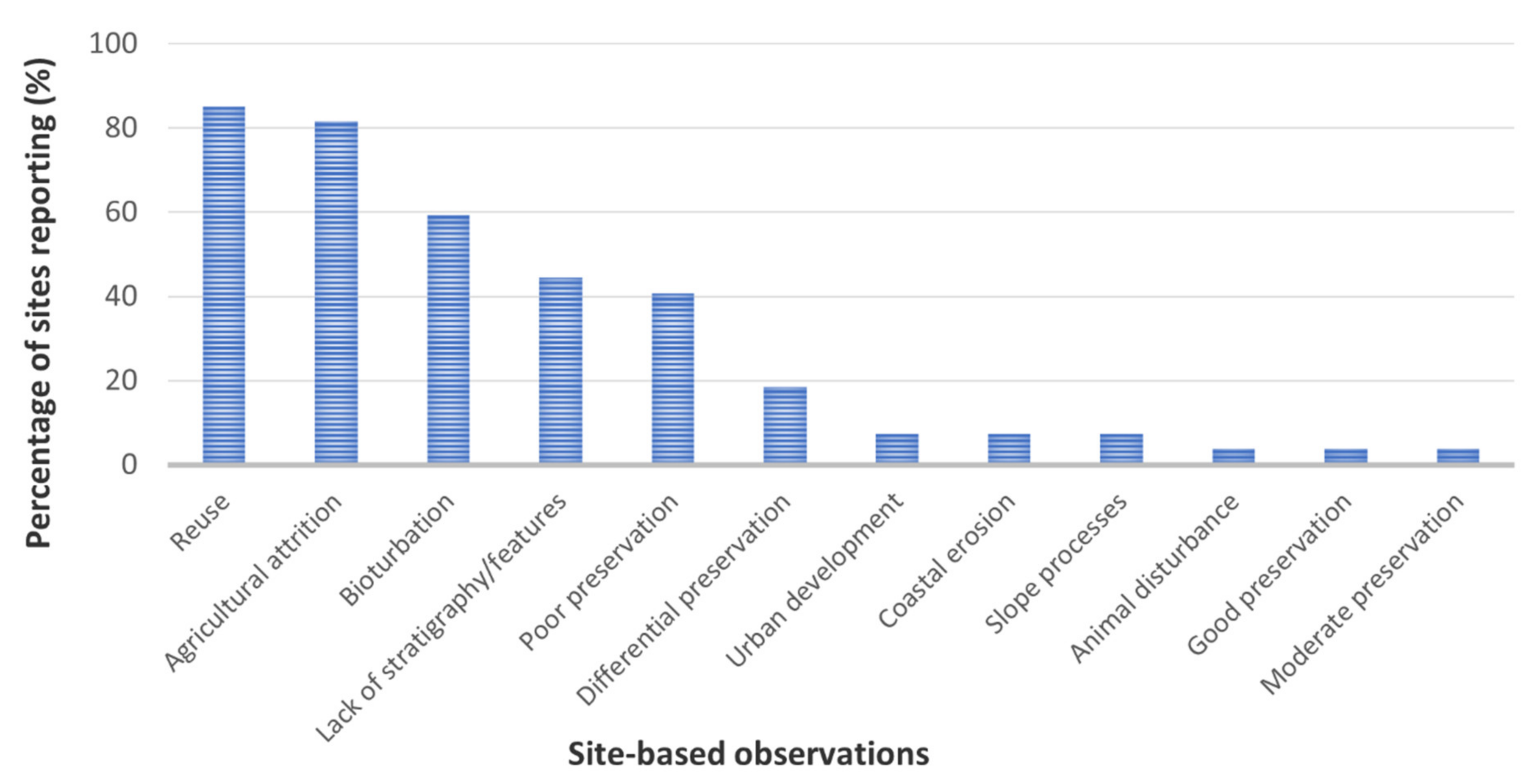
4.1. Phase 1: Site-Based Analysis

The literature review identified 12 observations relating to post-depositional processes across the 27 study sites (Figure 2). The major processes have been reported in Table 1 and in greater detail below.

4.1.1. Reuse of Sites

The direct reuse or remodelling of settlement features was found to have occurred at 23 of the sites studied (85.2%). This included the reuse of earlier settlement features by early medieval populations (37.0% of total sites) as well as the modification and reuse of early medieval settlement (66.7% of total sites).
Many structures had been incorporated into already populated landscapes (e.g., Pitcarmick, Grantown Road, Carn Dubh, Walton Road, Lair) and there was a significant trend in which early medieval dwellings respected or utilised prehistoric remains. Remodelling within the early medieval period was also evident at a number of sites including Lair, Portmahomack, Easter Kinnear/Hawkhill (Fife) and Dunnicaer. At the latter, the construction of multiple successive hearths and structures was interpreted as a response to rapid expansion within a limited space (possibly exacerbated by the impact of coastal erosion [56] (p. 32)). Post-abandonment activity typically served to truncate or rework material, and significant robbing of building material was recorded at eight of the sites studied (29.6%).

4.1.2. Agricultural Attrition

Agricultural attrition was recorded in 22 of the 27 sites analysed (81.5%). The most significant cases related to truncation as a result of modern ploughing, where all surficial evidence had been destroyed and the sites existed as negative features cut into the subsoil (e.g., Grantown Road, Macallan Distillery, Walton Road, Newbarns, Rhynie). Many features had been completely removed and, where deposits did survive, they existed as little as 0.02 m deep (Newbarns) and were often contaminated with subsoil or cut by plough furrows [78] (p. 105).
Ancillary activities had caused damage at six of the sites catalogued (22.2%). At Upper Gothens, this had disturbed over 75% of the cleaned surface and obliterated all archaeological features in a 12–15 m length stretch of the site [100] (p. 35). At Rhynie, cattle trampling was found to have exacerbated the plough erosion following the field’s conversion to pasture, resulting in a 9 m by 5 m erosion scar that exposed the subsoil [96] (p. 13).
Premodern agricultural activity was also recorded at 13 of the sites (48.1%), primarily in the form of ardmarks or rig and furrow. At Pitcarmick, this had removed walls, cut into floors, and spread material across the site. At Lair, plough furrows had accentuated the degradation of structures and contributed to the merging of turf wall and internal deposits [66] (p. 28). Notably, at Walton Road (where both modern and post-medieval ploughing had occurred), higher levels of truncation were observed in proximity to the remains of rig and furrow [103] (p. 33).

4.1.3. Bioturbation

The reworking of sediments by soil fauna was found to have had a significant impact at 16 of the sites studied (59.3%). In the most obvious cases, burrowing resulted in the truncation of features (Walton Road), unclear phasing (Rhynie), the movement of artefacts (Easter Kinnear, Lair) or the contamination of deposits with exogenous material (Newbarns, Macallan Distillery). Sites with sandy soils (e.g., Rhynie and Kintore) tended to report more significant impacts as a result of their loose and more easily penetrable soil structure. At Kintore, where the recovery of floor layers was limited, micromorphological analysis confirmed that the internal fabric of an early medieval structure had been destroyed through significant pedogenic processes including bioturbation, weathering and compaction [105] (p. 299).

4.1.4. Lack of Internal Stratigraphy/Features

Of the 22 sites that contained evidence of structures, 11 (50.0%) reported a lack of robust internal deposits. Those found in cropmark and greenfield sites typically presented with a complete lack of floor layers and very few internal features or finds (e.g., Rhynie, Grantown Road, Macallan Distillery).
An absence of floor deposits was also recorded at cropmark sites where structures had an erosional hollow or “scooped” component. No interior features were identified in the sunken building at Easter Kinnear, despite it surviving 1.5 m below the modern ground surface [57] (p. 83). Discovery of rough stone paving in a similar structure at nearby Hawkhill (Fife) suggested that a floor may have been removed prior to infilling; however, this too was unaccompanied by evidence of occupation deposits or a hearth. The later wattle-and-daub constructions at Easter Kinnear demonstrated a similar lack of floor layers, the reasons for which are unclear [57] (p. 89).
In upland sites where modern ploughing had not been a primary factor and structures remained upstanding (e.g., Carn Dubh, Lair, Litigan), interior deposits were similarly absent or had no coherent stratigraphy. Of the seven sub-rectangular buildings excavated at Lair, only Building 3 produced partial evidence of a possible floor layer. This was identified through its association with material culture (pottery, spindle whorl, burnt bone etc.) but was thin, and could not be mapped across the extent of the structure [28] (p. 112).
A notable exception to this trend was Portmahomack, where a clayey-silt/silt sequence was interpreted tentatively as the accumulation, or deliberate maintenance, of a beaten earth and ash floor [87] (p. 13). Occupation deposits were similarly evident at Dunnicaer and Burghead; however, truncation meant that the nature of the structures, or the degree to which their deposits represented the full extent of a building, were difficult to establish. At the former, this had resulted from the partial collapse of the sea stack, whilst, at the latter, it was due to the absence of evidence for enclosing walls [48]. Floor deposits were also recorded at Pitcarmick, though the site reports offered no indication over their condition or nature [27] (pp. 160, 171).

4.1.5. Preservation (Survival of Ecofacts/Artefacts)

Commentary on the preservation of artefacts and ecofacts primarily highlighted the relatively poor survival of organic remains. Plant remains were typically only recovered in carbonised form, and interpretations regarding past agriculture or land use were often limited by low count numbers and poor preservation (e.g., Carn Dubh [50] (pp. 176–178); Hawkhill (Angus) [59] (p. 41–45)). At Ardownie, 60–80% of the pollen recovered was classed as corroded or degraded, indicating substantial alteration of the original pollen record through processes such as oxidation and microbial activity [42] (p. 38–39).
Where recovered, bones were also found to be poorly preserved and typically only survived as small fragments of calcified material. This was largely attributed to aggressive conditions in free-draining acid soils; at Pitcarmick, ploughing and reuse for fuel were also put forward as potential post-depositional agents [27] (p. 181). More substantial bones were recovered at Rhynie (unburnt cattle remains in postpipes and a possible stone socket) and in the early medieval burial context at Hawkhill (Angus) but again their preservation was relatively poor, and this degree of survival was not consistent across either site.
Partial waterlogging at Portmahomack had resulted in the preservation of wooden artefacts, and the areas in and around Structure 9 were found to be exceptionally rich in well preserved cattle bones. Though lacking in organic materials, the artefact assemblage from Rhynie was equally impressive, producing more than 1000 artefacts over five seasons of excavation [98] (p. 76). This included significant evidence of metalworking, such as clay moulds, crucible fragments, crucible stands and metal tongs [9,97]. However, aside from these high-profile sites—where the majority of evidence related to on-site manufacturing—excavations typically produced few artefacts.

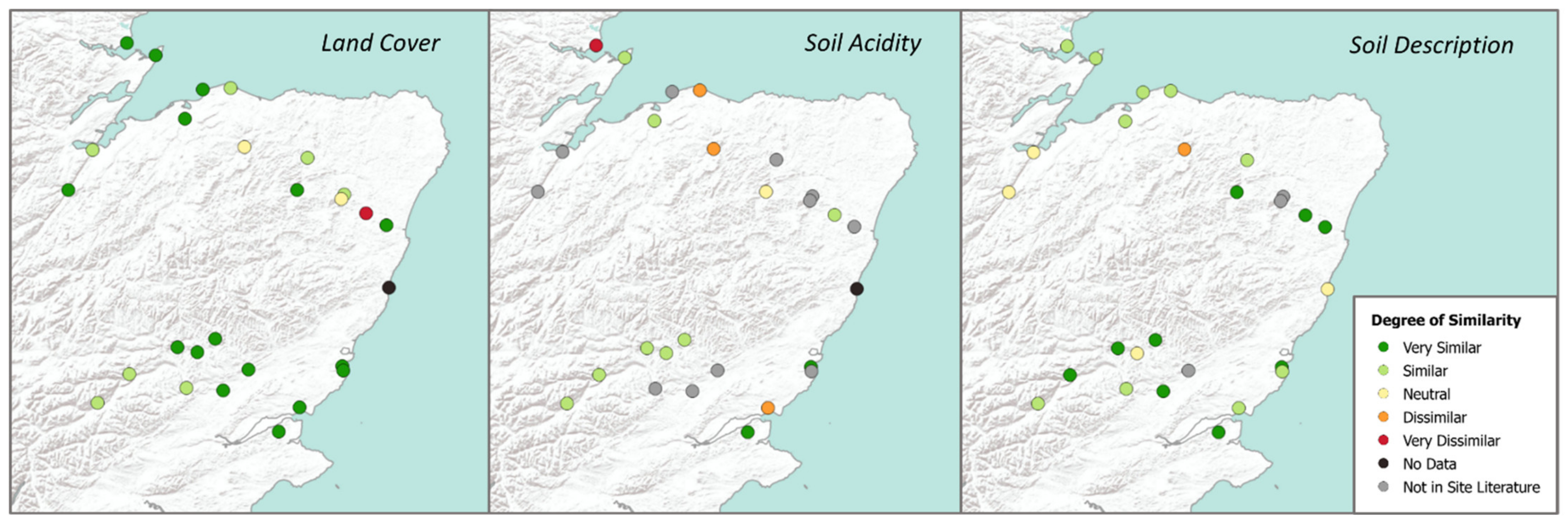
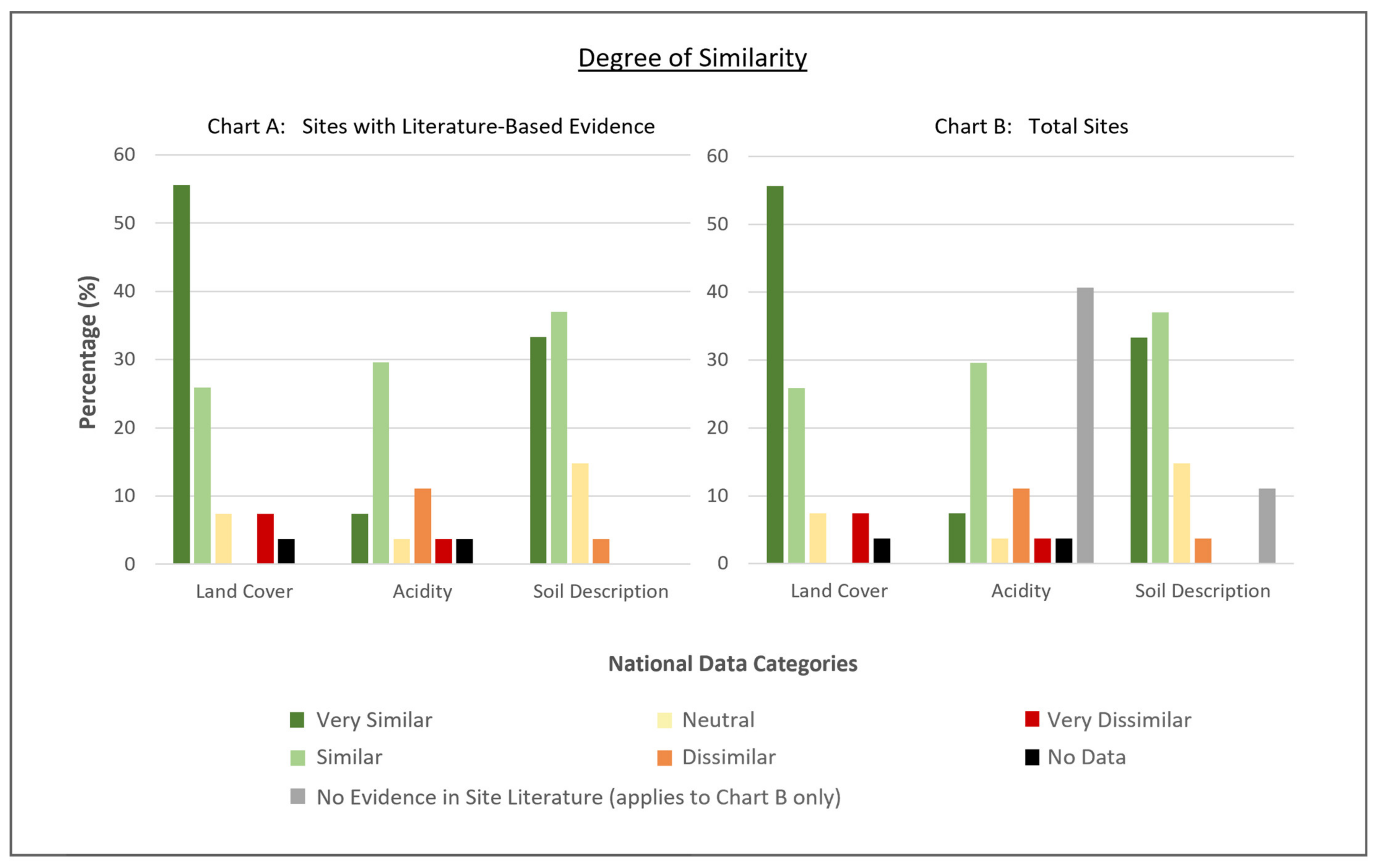
4.2. Phase 2: Comparison with National Data

Values and soil information collected for each site are recorded in Table 2. The degree to which these national data corresponded to the site-based literature is expressed geographically in Figure 3 and calculated as a percentage in Figure 4. Evidence relating to coastal erosion has been considered separately in Table 3 and Figure 5.
The assessment of similarity found a relatively high degree of correspondence across three of the national datasets (Chart A in Figure 4). The LCM2015 (land cover) proved to be the most accurate, with 85.2% of the comparable data having a Similar or Very Similar match with the site-based evidence. The SIFSS (soil description) produced a similar result, with 79.2% of the comparable data falling into these positive categories. The Soils of Scotland Topsoil pH dataset (acidity) had a slightly lower comparability, with 62.5% of the data having positive correspondence. When considering the total degree of similarity from all 27 sites (Chart B in Figure 4), this latter dataset had a much lower total comparability, with only 37.0% of the data falling into the Similar or Very Similar categories. This was largely the result of site reports not containing an assessment of the soil acidity or any evidence for the degradation/preservation of archaeological material.
In contrast to these datasets, the coastal erosion models were found to reflect site-based observations poorly. Whilst the NCCA Dynamic Coast did identify historic erosion on the north-west side of Burghead, it failed to return any information for Dunnicaer. The shoreline of a small bay to the north of the site was shown to have increased by over 16.5 m since 1967, but this is clearly an unsuitable proxy for the extensive erosion observed at Dunnicaer sea stack.
The CESM was similarly problematic, having categorised the north-west side of Burghead (an area considered to be most at risk of future loss [49]) as having a Low Susceptibility for coastal erosion. Whilst Dunnicaer’s location as a sea stack meant that it was not directly included in the mapping, its associated coastline was categorised as Very Low susceptibility—a clear contradiction to the site-based observations.

5. Discussion

5.1. Post-Depositional Processes

Given that the majority of sites were situated on arable or improved land (Table 2), it is unsurprising that agricultural attrition was one of the most significant processes affecting early medieval remains, both in the extent of destruction and the number of sites affected. This finding is consistent with broader studies that identified agriculture to be the most significant and widespread threat to both the UK and the world’s archaeological resource [107,108,109,110,111,112,113,114,115].
The most severe damage typically occurred through episodes of modern ploughing, and thus predominately affected sites in the arable zones of the lowlands (e.g., Rhynie, Upper Gothens, Newbarns). Experimental work has shown that, in these contexts, repeated ploughing can truncate sites by 0.07–0.1 m over a 30-year period [111] (p. 17–18). Several deposits within the arable sites lay within this threshold, indicating they may be lost within just a few decades of their excavation. The most obvious candidate for this loss is Newbarns, where the average surviving depth of excavated features was around 0.2 m, and some deposits were as shallow as 0.02 m [78]. In 2004, disturbed subsoil was recorded on both scheduled and unscheduled areas around the site, and discussions with the landowner indicated that penetrating the subsoil was unintentional and had most likely resulted from the plough cutting into slight elevations in the subsoil [116] (p. 31). Similar impacts were identified at Rhynie and Portmahomack, which both reported increased erosion on areas of topographic variation, such as knolls and crests [86] (p. 4), [98] (p. 69). Over time, these cases of imperfect ploughing contribute to the effective deepening of cultivation and the planing of archaeological deposits, but are likely to go unrecorded unless excavation or monitoring efforts are repeated [117].
One approach is to afford sites increased legal protection as Scheduled Monuments, effectively limiting the extent to which penetrative cultivation can occur. However, the legislation cannot control agricultural practices if it is shown that such activities occurred on the land within the previous ten years (Ancient Monuments (Class Consents) (Scotland) Order 1996). This means that ploughing can occur at a consistent depth even when ploughsoil thinning is observed, effectively bringing archaeological deposits closer to the zone of erasure. This was evidenced at Rhynie, Newbarns and Kinneddar, all of which had been afforded Scheduled status prior to excavation. A study of scheduled monuments in England (which are protected by similar legislation—Ancient Monuments (Class Consents) 1994) also found a considerable percentage of farmers had broken this Class Consent agreement, with 25% of the sites surveyed being subjected to deep ploughing and subsoiling [110] (p. ix). Given the evidence for truncation and subsoil disturbance, it is clear that early medieval settlement sites within the arable zone are at an increased risk of destruction and require a more effective management strategy.
Obliteration as a result of modern ploughing is one of the theories put forward for the general lack of early medieval settlement observed across Scotland [20]. Certainly, the use of more ephemeral building materials (turf or timber wattle) would result in less robust archaeological signatures; however, the high degree of reuse observed in the case study—both of previous settlement features and of early medieval structures—suggests that new sites may be eluding researchers simply as a result of their location amongst more prominent remains. The structures at Pitcarmick are located in a densely populated landscape, with remains stretching from the prehistoric to the 18th century, and they were not recognised as being of an early medieval date until a programme of survey and excavation in the late 1980s–1990s [27,118]. At Grantown Road and Macallan Distillery, the 9th to 12th century roundhouse structures had to be identified through radiocarbon dating, as the form was deemed unusual for such a late date and had no obvious parallels [58] (p. 69), [72] (pp. 19–20). There is also clear evidence for the reuse of hillforts and defensive structures and, in areas where early medieval settlement continues to elude researchers (e.g., Argyll), further examination of both populated landscapes and defended sites is likely to offer much needed detail.
Yet, even with the addition of new sites, a number of post-depositional processes are limiting the extent to which we can understand the settlement record. The decomposition of organic material in Scotland’s free-draining, acidic soils means that much of our understanding of manufacturing, status and society has come from metal artefacts [96,98]. These are largely restricted to high-status settlements and we are missing a wealth of detail from more rural settings. Whilst understanding soil conditions and drainage environments may help to identify areas where such artefacts can survive, many soils are expected to undergo increased desiccation as a result of climate change, and the opportunity to find such examples is limited [22] (p. 34). Environmental inputs are an additional concern, with studies demonstrating that the deterioration rate of artefacts—particularly inorganic materials—has accelerated in recent decades as a result of anthropogenic pollution [119,120]. To date, this has been linked to the limited number of metal finds observed on the Swedish west coast, whose acidic soils provide a point of comparison with the Scottish mainland [120] (p. 261). It has already been shown that Scottish soils have undergone considerable acidification in recent years [121] (p. 15), and failure to acknowledge this threat will result in a further loss of the settlement record.
This poor artefact preservation, coupled with a lack of occupation deposits or stratigraphy, has created an uncomfortable trend in which questions over economic activity and the organisation of social space often go unanswered. This problem is not unique to the north-east and has caused particular issue in the study of Norse Atlantic Scotland. Stratigraphy at the western settlement of Brough of Birsay in Orkney was found to be surprisingly shallow [122,123] (p. 16) and, despite being described as “the best preserved long-house in Scotland”, the multiple phases of activity and rebuilding at Hamar longhouse in Shetland had only partially survived later activity and erosion [124]. The top layers of soil had been stripped at some point in the site’s history and very few artefacts were recovered during its excavation.
The removal of internal deposits—intentionally or otherwise—provides one explanation for the general lack of stratigraphy observed across early medieval structures. In this scenario, cultivation or reuse are likely to be the primary agents; however, other anthropogenic factors include the use of floor coverings or maintenance practices that would have removed occupation build-up [31] (pp. 226–234), [125,126] (pp. 115–156), [127] (pp. 598–599). The preserved floor layers at Portmahomack certainly suggest episodes of regular maintenance, and remains from Underhoull Viking longhouse in Shetland have pointed towards the use of a wooden sprung platform that would have supported a hearth and kept the floor dry [123] (p. 16), [124]. This could explain the lack of hearths at Newbarns or Easter Kinnear; however, without comparative examples or more detailed evidence, the application of these practices within Scotland’s early medieval period remains unresolved.
The mixing of sediments by roots and soil fauna offers another explanation. Within the study area, sites appeared particularly susceptible to mammalian burrowing activity as they often comprised “soft” deposits such as turf and earthworks, or were located on sandy subsoils whose loose soil structure could be easily penetrated. Micromorphological analysis conducted at Brotchie’s Steading in Caithness (a multi-period settlement mound) has shown that invertebrates can have an extreme impact on archaeological deposits, with high levels of earthworm activity being responsible for the reworking of early medieval turf deposits into homogenous soils [128,129] (p. 274). Earthworms are the primary bioturbators in temperate soils, however their impact on archaeological sites is largely recognised through thin section analysis and may be missed if such techniques are not routinely employed [130,131]. This type of analysis has not yet been conducted on early medieval upland sites, and there is little evidence to support or deny the role of invertebrates in their alteration (although these sites were found to have the lowest pH values (Table 2) and studies have indicated that earthworm activity is likely to be limited at sites with very low pH [132]). The evidence from settlement in arable and grassland sites is more conclusive, with bulk analysis and micromorphology successfully identifying the remains of invertebrates, as well as their eggs and excreta [72] (p. 15), [105] (p. 299).
Buried remains in Scotland are expected to undergo increased rates of bioturbation as a result of climate change, where longer growing seasons will encourage the spread of new and invasive species, and deeper and more extensive root growth [22] (p. 33). A potential acceleration in the loss of soil stratigraphy should therefore prompt a review of the way these sites are investigated, and efforts should be made to understand not only the early medieval activity but also the rate and scale of degradation at site level.

5.2. Use of National Datasets

The relatively high degree of correspondence between national datasets and site-based observations suggests that these freely available resources could be used in an archaeological context (Figure 3 and Figure 4). As the datasets relate to modern values, their application will be best suited to remote assessments of current or projected risk; this could include scheduling applications, monument monitoring, conservation efforts or identifying candidates for rescue excavation. To this end, the LCM2015 is arguably the most valuable dataset for UK-based analysis, as the synonymity between land cover and land use permits an evaluation of the different levels of threat or protection afforded to archaeological remains (e.g., sites within an active arable zone are more at risk of attrition than those with heather covering, whilst areas of uncultivated land may be more at risk from rabbit burrowing [116] (p. 71), [133] (p. 1)).
However, categories within the dataset are relatively broad and direct application of the data could fail to address a wide variation in the extent and nature of post-depositional processes. The Arable and Horticulture category, for example, covers all active cultivation regimes and is unable to account for the different levels of threat associated with crop types (e.g., the deep ploughing regime required for potatoes is likely to be more harmful to subjacent archaeology than cereal crops [116] (p. 71)). Associated maps which directly characterise the arable land into specific crop parcels are available under an institutional licence and are likely to provide greater detail for these sites (UKCEH Land Cover® plus: Crops 2015, 2016, 2017, 2018 and 2019).
The LCM2015 also highlighted a broader issue over a lack of information regarding the impact of different land and vegetation covers on archaeological monuments. The best-preserved sites in the case study (Pitcarmick and Lair) had heather land cover, which is often subjected to controlled burning as a means of erosion control and vegetation management. There is currently no available literature addressing the impact of heather or its burning on archaeological monuments and it is clear that, if land cover data is to be of any real value, more detailed studies are needed to characterise these impacts [134] (p. 11).
Combining information is likely to more effectively utilise the datasets, as land cover and soil descriptions can be used to infer the likelihood that particular processes have impacted archaeological landscapes. For example, in an agricultural context, the loosely structured, free-draining sandy soils of the Boyndie Association are unlikely to require de-stoning, extensive drainage programmes or subsoiling to remove compaction pans [116] (p. 30). In sites susceptible to periodic waterlogging, the reverse may be true. At Upper Gothens, where archaeological remains had been extensively damaged due to subsoiling, drainage works and heavy machinery bogging down in wet conditions [100], the LCM2015 was able to identify that the site was in active agricultural land, whilst the SIFSS indicated it was situated on a soil with imperfect drainage (Table 2).
In contributing to the soil information, the Soils of Scotland Topsoil pH map does appear to provide a suitable proxy for site acidity; however, the evaluation was limited by a lack of numerical data in the literature. Few reports directly commented on the acidity of a site, and even fewer had actually conducted pH assessments. Therefore, the degree to which the data corresponded had to be based on descriptions of degradation rather than comparable values. This introduced a range of interpretational biases and it is currently not possible to say whether national pH mapping is a suitable way to estimate this aspect of the preservation environment.
A methodological issue recognised over the course of this study related to the fact that values and information for each site were established using a single grid reference. This only reflects one point in an archaeological landscape and introduces a geographical bias with regards to where data are collected. This was particularly pronounced in larger sites such as Portmahomack, where excavations occurred on both pastural and arable lands, as well as within an upstanding church. Future applications could overcome this by examining the wider area of the site or, for the pH dataset, taking point values across the area to check for erroneous results.
The poor correspondence between site-based observations and national coastal erosion models suggests that these are currently unsuitable for the remote assessment of coastal sites. Though just two sites were analysed, these findings are consistent with the case study on Sanday, Orkney, that found neither model to be a suitable reflection of erosional events [35].
Given the lack of evidence for early medieval settlement recovered from present-day urban contexts, a comparison of national datasets with urban sites could not be achieved. However, neither the topsoil pH dataset nor the soil description dataset (SIFSS) provide values for densely populated urban areas such as cities, instead characterising them with a pH value of 0 or QMUNIT 608 (Association: Built-Up) respectively. As such, national datasets are currently unable to provide a method of preservation assessment in modern urban contexts.
It is also recognised that the preservation factors assessed in this study (land use, soil acidity, soil type) do not exclusively determine the retention or decay of archaeological materials. Factors such as soil compaction, soil water level and organic matter content are significant contributors that can also influence a number of other preservation conditions. For example, dewatering can result in the shrinkage or erosion of deposits, increased biological activity, increased acidity and the corrosion of artefacts [135] (p. 3). However, such conditions are rarely considered, much less characterised, during excavation or site-monitoring, and the relationship between these factors and our understanding of how archaeology responds to changing soil properties remains limited. In Scotland, national soil surveys on water capacity [136], organic carbon concentration [137] and erosion and compaction risk [138,139,140] have the potential to inform and predict these processes, however their use is currently restricted by a lack of comparative detail at the site-level.
Finally, a lack of national data relating to important post-depositional processes, such as bioturbation and fluctuating groundwater, means that remote assessment can only offer information on certain aspects of the preservation environment. There are currently no national archives regarding soil macrofauna, earthworm populations or redox conditions, and thus we are missing a significant understanding of the relationship between different land covers, soil types, pH and animal activity. Moreover, bioturbation was only partially explored in the excavation literature and, in order to understand the prevalence of this process across early medieval sites or Scotland’s archaeological resource more broadly, further soil surveys and dedicated case studies are required.

5.3. Implications for Future Practice

As highlighted above, preservation potentials across Scotland’s early medieval settlement sites are relatively poor and are set to change further over the coming decades. The assumption that archaeological material is best preserved in situ is quickly losing credence among both researchers and heritage bodies, and alternative strategies are being considered at all levels of care [21,22]. In situations where negative conditions cannot be halted, reversed or significantly impeded, excavation is now being actively promoted as a management plan [22].
To ensure that these strategies are administered appropriately, heritage managers must be able to estimate the current and projected risk faced by specific archaeological sites. The methods outlined in this study have offered one means of considering preservation and risk, but equally highlight the issues associated with basing an analysis solely on a literature review or generalised and proxy data. A handful of countries have developed risk maps as a more rational and economical means of undertaking the management of archaeological monuments, but these almost exclusively deal with upstanding or architectural remains, and the analysis of risk typically concentrates on catastrophic events such as earthquakes and flooding [4,5,6], or the long-term effects of pollution, tourism, erosion and climate change [5,7,8]. By contrast, risk maps concerning buried heritage, or the post-depositional events experienced at the soil interface, are noticeably lacking. As this study has demonstrated, national soil datasets can provide some broad indications of risk that are of value to heritage managers, but major factors are missing, and the mapping resolution is ultimately too low for site-specific management [141] (pp. 54–60).
However, there is still considerable potential for these resources to inform archaeological risk mapping if combined with site-based evidence collected from excavations and monitoring efforts. Such a resource would need to be dynamic and regularly updated as more information is made available about conditions at the site-level. This would produce a dataset that not only indicates risk but actively encourages research into post-depositional processes, the relationships between factors, and how the different aspects of settlement (architectural styles, building materials, longevity of use etc.) can influence these impacts. However, as this study has shown, observations made at the site-level need to be more detailed and include empirical data that can be directly compared against sites and across geographical and environmental settings.
Excavation is the most direct means of accessing information related to preservation conditions but the methods used can also cause interpretational issues. Keyhole excavation has been the most widely applied strategy in the assessment of Scotland’s early medieval settlement but has often failed to highlight areas of good preservation or provide any meaningful commentary on the overall condition of a site [23]. “Strip-and-map” recording methods—in which large trenches are opened, cleaned and mapped—were used at both Rhynie and Portmahomack, and proved valuable in providing a more complete evaluation of the sites [84,142]. However, this technique has seen limited uptake in commercial contexts, as it requires a large workforce and can often fail to address some of the more detailed questions regarding preservation and natural or cultural formation processes [142] (p. 556). Removing such a large quantity of topsoil can also leave sites vulnerable to intrusion or make them more susceptible to the damaging impact of cultivation. Whilst compaction of the soil following reinstation is believed to mediate these issues, there is not yet a body of evidence to assure minimal impact [142] (p. 556).
Moving forward, the most valuable approaches will be those that clarify both the post-depositional processes and their agents, as well as those which provide the empirical data required for comparative analysis. Geoarchaeology is an obvious candidate, offering a range of techniques that can be applied at a variety of scales and to different environmental and cultural contexts. At Bornais, on the island of South Uist, for example, micromorphology was able to identify that 7th–9th century AD occupation deposits had been altered through episodes of trampling, digging and maintenance, as well as the addition of turf and hearth material [143]. At the multi-period settlement site of Old Scatness in Shetland, this technique was combined with phosphate analysis and particle-size distribution in order to track changes to agricultural methods over time. The analysis of arable soils revealed that domestic waste, floor material and ash were all used as soil amendments for much of the Iron Age, but that organic material only became an integral part of the manuring strategy towards the middle of the first millennium AD [144,145]. This increase in animal manure indicated a change in the relationship between arable farming and livestock husbandry, and offered insight into the increasing organisation of the resources required for agriculture [145] (p. 84).
However, across Scotland, much of the work to date has been concentrated in the Northern or Western Isles, and comparative work on mainland sites is somewhat lacking. This is particularly true across sites dated to the first millennium AD, which, given their tendency for poor preservation, is in need of addressing. Chemical analysis (phosphate and multi-element by XRF) has been employed in an attempt to locate hearths or identify activity “hotspots” on mainland early medieval sites, but interpretations of the results rarely go beyond presence/absence (e.g., [65] (p. 9), [146]). Micromorphology has proven to be a more effective tool, having recognised maintenance practices, post-depositional mixing by invertebrates, and the eluviation of fine material by rainwater (e.g., [105] (p. 299–300)). However, again, there are gaps in the knowledge, with significant sites such as Pitcarmick having not benefitted from the application of the technique or the publication of its results. Studies outside Scotland have already highlighted the ability of this technique to identify occupation deposits and activity areas that are not apparent during excavation (see [147]) and, given the lack of stratigraphy observed across the study area, this should be a significant consideration for future research.
Given that many of the questions regarding preservation conditions occur across a range of environmental settings, comparing micromorphological samples from different contexts may be an appropriate place to start. Alternative applications of geoarchaeological techniques include the monitoring of soil conditions at sites where in situ preservation is practised [135,148]. Historic Environment Scotland have noted that their current monitoring practice is not sufficient for scheduled monuments buried beneath the ploughsoil and does not produce data that can be combined or compared against other monument types [117]. Geochemical analysis has also been shown to improve the results of geophysics in Scottish contexts [149], and further developing this relationship may yet result in the identification of sites in contexts where current archaeological approaches have failed. As of yet, there are no guidelines for the application of geoarchaeology in Scotland, and future excavations would likely benefit from such documentation.

6. Conclusions

The analysis conducted in this case study has highlighted a number of factors with significant implications for both early medieval Scotland and settlement research more broadly. First, and perhaps most obviously, it has identified that the condition of each site is the consequence of multiple natural and anthropogenic events. Primarily, these relate to the destruction, removal or alteration of the archaeological record, and by presenting a spectrum of observed data, it has been possible to identify the factors most likely to affect early medieval sites across a range of environmental contexts. Agriculture and reuse have already dealt significant damage to the settlement record but equally offer a place to look for new sites and begin addressing questions concerning geographic lacunae. In considering the future of Scotland’s early medieval settlement remains, the identification of widespread bioturbation, aggressive soil environments, coastal erosion and continued agricultural attrition is paramount. The threat posed by each of these processes cannot be understated and, as climate change continues to alter and accelerate their nature, the way we approach the archaeological record becomes vitally important.
Moving forward, the ability to predict sites most at risk of alteration (or those that currently have the best examples of preservation) will be critical in ensuring effective management. National soil datasets have the potential to form the basis of heritage risk maps that focus on post-depositional processes but are of limited value in their current form. Should they be incorporated into a dynamic map, they would provide a useful foundation to which higher resolution data could be added. New excavations and monitoring efforts which directly incorporate questions about the preservation environment into their research design will therefore be key in addressing the current absence of detail.
Although this evaluation used eastern Scotland as a case study, the implications extend beyond its regional bounds. The comparison of site-based evidence with national datasets offers a means to develop a foundational understanding of the factors impacting archaeological preservation, and to recognise key knowledge gaps in both the archaeological corpus and wider resources. This can be adapted to cover any temporal scale and would be particularly effective in circumstances where post-depositional events are unclear or have proven difficult to access. In such cases, the results are likely to produce more comprehensive interpretations and shape more effective management strategies. Moreover, international studies are likely to identify trends in post-depositional processes and create a broader understanding of how the various aspects of settlement (e.g., architecture, building material and longevity of use) influence states of preservation and post-depositional signatures. It is therefore hoped that, by providing a methodology that can be applied worldwide, the current study will prompt a review of how we approach site formation histories and the tools that can be used to consider both past and future threats.

Supplementary Materials

The following are available online at https://0-www-mdpi-com.brum.beds.ac.uk/article/10.3390/heritage4020041/s1, Document S1: List of search terms used in analysis of excavation literature.

Author Contributions

Conceptualisation, V.R. and K.M.; Methodology, V.R.; Formal analysis, V.R.; Writing—Original Draft Preparation, V.R.; Writing—Review and Editing, K.M. and V.R.; Visualisation, V.R.; Supervision, K.M.; Funding Acquisition, K.M. All authors have read and agreed to the published version of the manuscript.

Funding

This research was funded by the Natural Environment Research Council, UK [NERC IAPETUS DTP, grant number NE/L002590/1].

Data Availability Statement

The data presented in this study are available within the body of the article. Reports contributing to the data are largely published; however, occasional restrictions do apply to their availability. Where reports were unpublished, data were obtained by the corresponding author and have been used with permission. The national datasets are freely available and can be accessed via their online hosting platforms (links supplied in the References section of this article).

Acknowledgments

The authors would like to thank Robin Coningham (Durham University), Ian Simpson (University of Stirling) and three anonymous reviewers for their valuable comments on this paper. We would also like to thank Gordon Noble (University of Aberdeen), Murray Cook (Stirling Council) and David Strachan (Perth and Kinross Heritage Trust) for kindly providing unpublished excavation reports that contributed to the site-based assessments.

Conflicts of Interest

The authors declare no conflict of interest. The funders had no role in the design of the study, in the collection, analyses, or interpretation of data, in the writing of the manuscript, or in the decision to publish the results.

Appendix A

Ranking criteria used to assess degree of similarity in Phase 2 of the Methodology (Article Section 3.2). For all tables: VS = Very Similar; S = Similar; N = Neutral; D = Dissimilar; VD = Very Dissimilar; ND = No Data; NR = Not Reported.
Table A1. Land cover.
VSIdentical/near identical description (e.g., pine forest vs. coniferous woodland)
SSimilar description (e.g., woodland vs. coniferous woodland)
NLand cover difficult to establish in site report; not explicitly stated and may be inferred from other details; neither agrees nor disagrees with national data
DDescriptions do not match well and would fall into different categories, but there is a degree of association (e.g., improved grassland vs. arable)
VDDescriptions would fall into different land cover categories with no common element (e.g., urban vs. arable)
NDNo national data
NRLand cover type not mentioned in site report
Table A2. Soil acidity.
VSVery close match with site report (e.g., pH value of ~4 vs. “very acidic” or very similar value)
SSimilar match with site report (e.g., pH value of ~4 vs. “acidic” or similar value); acidity/alkalinity may not be explicitly clear in site report and may have been inferred from degradation levels
NConflicting evidence of acidity/preservation environment in site report; not clear whether national data agrees or disagrees
DDissimilar match with site report (e.g., pH value of ~4 vs. “moderately acidic” or significantly different value); acidity/alkalinity may not be explicitly clear in site report and may have been inferred from degradation levels
VDVery dissimilar match with site report (e.g., “acidic” vs. pH > 7)
NDNo national data
NRpH/acidity or degradation/preservation levels not mentioned in site report
Table A3. Soil description.
VSVery close match with soil properties reported in site literature; report may have acknowledged map unit, soil association and/or soil series
SGood match with site report where soil descriptions match well and are likely to indicate the same soil type (soil association, series or type may not have been explicitly addressed but can be inferred)
NNeutral—conflicting evidence within site report; may include/omit certain soil types and properties; descriptions of soil in site report but unclear what soil type they belong to; neither agrees nor disagrees with national data
DPoor match with site report where soils descriptions do not match well and are likely to indicate an alternative soil type (soil association, series or type may not have been explicitly addressed but can be inferred)
VDClear disagreement with site report; report may have mentioned different soil association or soil type
NDNo national data
NRSoil information not mentioned in site report
Table A4. Coastal erosion (NCCA). Similarity ranking only conducted on sites with reports of coastal erosion.
VSShoreline changes correlate well with areas of erosion identified in site reports
SGeneral recognition of past erosion across site but areas or severity may not fully align
NAreas of erosion recognised but do not match well with site reports
DNo changes identified in areas of reported erosion
VDAreas of accretion mapped in areas of reported erosion
NDNo national data (area of coastline not mapped)
NRCoastal erosion not mentioned in site report
Table A5. Coastal erosion (CESM). Similarity ranking only conducted on sites with reports of coastal erosion.
VSDegree of susceptibility correlates very strongly with shoreline changes identified in site report (e.g., Very High/High susceptibility in areas of extensive erosion)
SDegree of susceptibility correlates well but slightly over/underestimates the severity (e.g., Medium susceptibility in areas of extensive erosion); areas may not fully align
NErosion susceptibility acknowledged but specific areas do not align well with site report
DDegree of susceptibility does not match well with site report (e.g., Low susceptibility in areas of extensive erosion)
VDDegree of susceptibility vastly different from site report (e.g., Very Low susceptibility in areas of extensive erosion)
NDNo national data (area of coastline not mapped)
NRCoastal erosion not mentioned in site report

References

  1. Dekker, L.W.; De Weerd, M.D. The value of soil survey for archaeology. Geoderma 1973, 10, 169–178. [Google Scholar] [CrossRef]
  2. Almy, M.M. The archaeological potential of soil survey reports. Fla. Anthropol. 1978, 31, 75–91. [Google Scholar]
  3. Layzell, A.L.; Mandel, R.D. Using soil survey data as a predictive tool for locating deeply buried archaeological deposits in stream valleys of the Midwest, United States. Geoarchaeology 2019, 34, 80–99. [Google Scholar] [CrossRef] [Green Version]
  4. Wang, J. Flood risk maps to cultural heritage: Measures and process. J. Cult. Herit. 2015, 16, 210–220. [Google Scholar] [CrossRef]
  5. Accardo, G.; Giani, E.; Giovagnoli, A. The risk map of Italian cultural heritage. J. Architect. Conserv. 2003, 9, 41–57. [Google Scholar] [CrossRef]
  6. Scalet, M.; Poletto, D.; Cavinato, G.P.; Moscatelli, M. (Eds.) Disaster Risk Management of Cultural Heritage Sites in Albania; CNR IGAG: Rome, Italy, 2014. [Google Scholar]
  7. Paolini, A.; Vafadari, A.; Cesaro, G.; Quintero, M.S.; Van Balen, K.; Vileikis, O.; Fakhoury, L. Risk Management at Heritage Sites: A Case Study of the Petra World Heritage Site; UNESCO: Paris, France, 2012. [Google Scholar]
  8. Wu, P.S.; Hsieh, C.M.; Hsu, M.F. Using heritage risk maps as an approach for estimating the climate impact to cultural heritage materials in the island of Taiwan. In Digital Heritage. Progress in Cultural Heritage: Documentation, Preservation, and Protection. EuroMed 2014. Lecture Notes in Computer Science; Ioannides, M., Magnenat-Thalmann, N., Fink, E., Žarnić, R., Yen, A.Y., Quak, E., Eds.; Springer: Cham, Switzerland, 2014; Volume 8740. [Google Scholar]
  9. Noble, G.; Gondek, M.; Campbell, E.; Cook, M. Between prehistory and history: The archaeological detection of social change among the Picts. Antiquity 2013, 87, 1136–1150. [Google Scholar] [CrossRef] [Green Version]
  10. Evans, N. A historical introduction to the northern picts. In The King in the North: The Pictish Realms of Fortriu and Ce; Noble, G., Evans, N., Eds.; Birlinn: Edinburgh, UK, 2019; pp. 10–38. [Google Scholar]
  11. Close-Brooks, J. Pictish and other burials. Pictish studies: Settlement, burial and art in dark age Northern Britain. Br. Archaeol. Rep. Br. Ser. 1984, 125, 87–114. [Google Scholar]
  12. Maldonado, A. Burial in early medieval Scotland: New questions. Mediev. Archaeol. 2013, 57, 1–34. [Google Scholar] [CrossRef]
  13. Lane, A.; Campbell, E. Dunadd: An. Early Dalriadic Capital; Oxbow Books: Oxford, UK, 2000. [Google Scholar]
  14. Alcock, L. Kings and Warriors, Craftsmen and Priests in Northern Britain AD 550–850; Society of Antiquaries of Scotland: Edinburgh, UK, 2003. [Google Scholar]
  15. Cook, M.J. New evidence for the activities of Pictish potentates in Aberdeenshire: The hillforts of Strathdon. Proc. Soc. Antiqu. Scotl. 2011, 141, 207–231. [Google Scholar]
  16. Clarke, D.; Blackwell, A.; Goldberg, M. Early Medieval Scotland: Individuals, Communities and Ideas; National Museum of Scotland: Edinburgh, UK, 2012. [Google Scholar]
  17. Noble, G.; Goldberg, M.; Hamilton, D. The development of the Pictish symbol system: Inscribing identity beyond the edges of Empire. Antiquity 2018, 92, 1329–1348. [Google Scholar] [CrossRef]
  18. Campbell, E.; Batey, C. Early medieval Argyll and Norse/Viking Argyll (AD 400-1100). Regional Archaeological Research Framework for Argyll. 2017. Available online: https://tinyurl.com/r3zj5uo (accessed on 26 July 2020).
  19. Bowler, D.P. Perth: The Archaeology and Development of a Scottish Burgh; Tayside and Fife Archaeological Committee: Perth, UK, 2004. [Google Scholar]
  20. Dunwell, A.; Ralston, I.B.M. Archaeology and Early History of Angus; The History Press: Stroud, UK, 2008. [Google Scholar]
  21. Van de Noort, R.; Chapman, H.P.; Cheetham, J.L. In situ preservation as a dynamic process: The example of Sutton Common, UK. Antiquity 2001, 75, 94–100. [Google Scholar] [CrossRef]
  22. Harkin, D.; Hyslop, E.; Johnson, H.; Tracey, E. A Guide to Climate Change Impacts on Scotlands Historic Environment; Historic Environment Scotland: Edinburgh, UK, 2019. [Google Scholar]
  23. Driscoll, S.T. Pictish archaeology: Persistent problems and structural solutions. In Pictish Progress: New Studies on Northern Britain in the Early Middle Ages; Driscoll, S., Geddes, J., Hall, M.A., Eds.; Brill: Leiden, UK, 2010; pp. 245–280. [Google Scholar]
  24. Ralston, I. Pictish homes. In The Worm, the Germ and the Thorn: Pictish and Related Studies Presented to Isabel Henderson; Henry, D., Ed.; Pinkfoot Press: Balgavies, Scotland, UK, 1997; pp. 18–34. [Google Scholar]
  25. Geddes, G. Vernacular buildings of the outer hebrides 300 BC–AD 1930: Temporal comparison using archaeological analysis. Internet Archaeol. 2006, 19. [Google Scholar] [CrossRef]
  26. Noble, G. Fortified settlement in northern Pictland. In The King in the North: The Pictish Realms of Fortriu and Ce; Noble, G., Evans, N., Eds.; Birlinn: Edinburgh, UK, 2019; pp. 39–57. [Google Scholar]
  27. Carver, M.; Barrett, J.; Downes, J.; Hooper, J. Pictish byre-house at Pitcarmick and their landscape: Investigations 1993–1995. Proc. Soc. Antiqu. Scotl. 2012, 142, 145–199. [Google Scholar]
  28. Strachan, D.; Sneddon, D.; Tipping, R. Early Medieval Settlement in Upland Perthshire; Excavations at Lair, Glen Shee, 2012–2017; Archaeopress: Oxford, UK, 2019. [Google Scholar]
  29. Proudfoot, E.V.W. The Society of Antiquaries of Scotland archaeological field survey. Proc. Soc. Antiqu. Scotl. 1982, 112, 1–16. [Google Scholar]
  30. Shahack-Gross, R. Archaeological formation theory and geoarchaeology: State-of-the-art in 2016. J. Archaeol. Sci. 2017, 79, 36–43. [Google Scholar] [CrossRef]
  31. Macphail, R.I.; Goldberg, P. Applied Soils and Micromorphology in Archaeology; Cambridge University Press: Cambridge, UK, 2018. [Google Scholar]
  32. Fitton, J.M.; Hansom, J.D.; Rennie, A.F. A national coastal erosion susceptibility model for Scotland. Ocean Coast. Manag. 2016, 132, 80–89. [Google Scholar] [CrossRef] [Green Version]
  33. Hansom, J.D.; Fitton, J.M.; Rennie, A.F. 2017. Dynamic Coast-National Coastal Change Assessment: National Overview; Centre of Expertise for Waters: Aberdeen, UK, 2017. [Google Scholar]
  34. Dynamic Coast. Dynamic Coast.: Web Map. Online mapping service. 2020. Available online: http://www.dynamiccoast.com/webmap.html (accessed on 12 June 2020).
  35. Boyd, S. From stones to bones: Studying Scottish coastal change with SCAPE and Dynamic Coast. 2019. Available online: https://wp.me/p2waVy-sk (accessed on 8 May 2020).
  36. Noble, G.; Evans, N. (Eds.) The King in the North.: The Pictish Realms of Fortriu and Ce; Birlinn: Edinburgh, UK, 2019. [Google Scholar]
  37. Esri. World Terrain Base [basemap]. 2020. Available online: https://www.arcgis.com/home/item.html?id=33064a20de0c48d2bb61efa8faca93a8 (accessed on 18 September 2020).
  38. Rowland, C.S.; Morton, R.D.; Carrasco, L.; McShane, G.; ONeil, A.W.; Wood, C.M. Land Cover Map 2015 (Vector, GB); NERC Environmental Information Data Centre: London, UK, 2017. [Google Scholar]
  39. Fitton, J.M.; Hansom, J.D.; Rennie, A.F. A national coastal erosion susceptibility model for Scotland–online resource. 2016. Available online: http://www.jmfitton.xyz/cesm_scotland/ (accessed on 12 June 2020).
  40. James Hutton Institute. soil_pH-W-Median; James Hutton Institute Soil Maps. 2012. Available online: https://www.hutton.ac.uk/learning/natural-resource-datasets/soilshutton/soils-maps-scotland/download#soilmapdata (accessed on 10 July 2020).
  41. James Hutton Institute. Soil Information for Scottish Soils (SIFSS). 2020. Available online: http://sifss.hutton.ac.uk/SSKIB_Stats.php (accessed on 7 July 2020).
  42. Anderson, S.; Rees, A.R. The excavation of a large double-chambered souterrain at Ardownie Farm Cottages, Monifieth, Angus. Tayside Fife Archaeol. J. 2006, 8, 19–76. [Google Scholar]
  43. Cook, M.; McCormick, T.; Kdolska, H. Battle Hill, Prehistoric Landscape Project, Huntly, Aberdeenshire: Season 1; Data structure report; 2017. [Google Scholar]
  44. Cook, M.; McCormick, T.; Kdolska, H. Battle Hill, Prehistoric Landscape Project, Huntly, Aberdeenshire: Season 2; Data structure report; 2018. [Google Scholar]
  45. Cook, M.; McCormick, T.; Kdolska, H. Battle Hill, Prehistoric Landscape Project, Huntly, Aberdeenshire: Season 3. Data structure report; 2019. [Google Scholar]
  46. Sveinbjarnarson, O. Burghead Data Structure Report; Data structure report; University of Aberdeen: Aberdeen, UK, 2016. [Google Scholar]
  47. Sveinbjarnarson, O. Burghead Data Structure Report; Data structure report; University of Aberdeen: Aberdeen, UK, 2017. [Google Scholar]
  48. Sveinbjarnarson, O. The Northern Picts Project: Excavations within the Upper Citadel; Unpublished summary report; University of Aberdeen: Aberdeen, UK.
  49. Noble, G.; MacIver, C.; Masson-Maclean, E.; O’Driscoll, J. Burghead 2018: Dating the Enclosing Elements and Characterizing the Survival and Use of the Lower Citadel; Data structure report; University of Aberdeen: Aberdeen, UK, 2018. [Google Scholar]
  50. Rideout, J.S. Carn Dubh, Moulin, Perthshire: Survey and excavation of an archaeological landscape 1987–1990. Proc. Soc. Antiqu. Scotl. 1995, 125, 139–195. [Google Scholar]
  51. Peteranna, M.; Birch, S. Craig Phadrig Hillfort, Inverness: Archaeological Evaluation; Data structure report; AOC Archaeology: Cromarty, Scotland, UK, 2015. [Google Scholar]
  52. Peteranna, M.; Birch, S. Storm damage at Craig Phadrig hillfort, Inverness: Results of the emergency archaeological evaluation. Proc. Soc. Antiqu. Scotl. 2019, 148, 61–83. [Google Scholar]
  53. Noble, G.; Sveinbjarnarson, O.; Stratigos, M.; Christie, C.; Rees, V.; Lenfert, R.; Paterson, D. Dunnicaer Sea Stack Evaluation 2015; Data structure report; University of Aberdeen: Aberdeen, UK, 2015. [Google Scholar]
  54. Noble, G.; Evans, N.; Hamilton, D.; MacIver, C.; Masson-MacLean, E.; O’Driscoll, J.; Cruickshanks, G.; Hunter, F.; Ingemark, D.; Mainland, I.; et al. Dunnicaer, Aberdeenshire, Scotland: A Roman Iron Age promontory fort beyond the frontier. Archaeol. J. 2020. [Google Scholar] [CrossRef]
  55. Noble, G.; MacIver, C. Dunnicaer Sea Stack Evaluation 2016; Data structure report; University of Aberdeen: Aberdeen, UK, 2016. [Google Scholar]
  56. Noble, G.; MacIver, C. Dunnicaer Sea Stack Evaluation 2017; Data structure report; University of Aberdeen: Aberdeen, UK, 2017. [Google Scholar]
  57. Driscoll, S.T. Pictish settlement in north-east Fife: The Scottish Field School of Archaeology excavations at Easter Kinnear. Tayside Fife Archaeol. J. 1997, 3, 74–118. [Google Scholar]
  58. Cook, M. Prehistoric settlement patterns in the north-east of Scotland; excavations at Grantown Road, Forres 2002–2013. Scott. Archaeol. Internet Rep. 2016, 61. [Google Scholar] [CrossRef]
  59. Rees, A.R. The excavation of an Iron Age unenclosed settlement and an early historic multiple burial and metalworking area at Hawkhill, Lunan Bay, Angus. Tayside Fife Archaeol. J. 2009, 15, 22–72. [Google Scholar]
  60. Atkinson, J.A. Buildings T16 and T17 at Kiltyre: The early occupation. Ben Lawers: An archaeological landscape in time. Scott. Archaeol. Internet Rep. 2016, 62, 71–77. [Google Scholar] [CrossRef]
  61. MacIver, C.; Cook, M.; Heald, A.; Strachan, D.; Roper, K.; Malone, S. Kings Seat, Dunkeld, Perth and Kinross: Archaeological Evaluation Phase 1; Data structure report; AOC Archaeology: Edinburgh, UK, 2017. [Google Scholar]
  62. MacIver, C.; Cook, M.; Heald, A.; Robertson, Y.; McLaren, D.; Strachan, D.; Lindsay, G. Kings Seat, Dunkeld, Perth and Kinross: Archaeological Evaluation Phase 2; Data structure report; AOC Archaeology: Edinburgh, UK, 2018. [Google Scholar]
  63. Noble, G.; Cruickshanks, G.; Dunbar, L.; Evans, N.; Hall, D.; Hamilton, D.; MacIver, C.; Masson-Maclean, E.; O’Driscoll, J.; Paskulin, L.; et al. A major ecclesiastical centre of the Picts. Proc. Soc. Antiqu. Scotl. 2019, 148, 113–145. [Google Scholar] [CrossRef]
  64. Cook, M.; Dunbar, L. Rituals, Roundhouses and Romans: Excavations at Kintore, Aberdeenshire, 2000–2006, Volume 1 Forest Road; Scottish Trust for Archaeological Research: Edinburgh, UK, 2008. [Google Scholar]
  65. Strachan, D.; Sneddon, D. Glenshee Archaeology Project: 2012 Excavation; Data structure report; Perth and Kinross Heritage Trust: Perth, UK, 2012. [Google Scholar]
  66. Strachan, D.; Sneddon, D. Glenshee Archaeology Project: 2013 Excavation; Data structure report; Perth and Kinross Heritage Trust: Perth, UK, 2013. [Google Scholar]
  67. Strachan, D.; Sneddon, D. Glenshee Archaeology Project: 2014 Excavation; Data structure report; Perth and Kinross Heritage Trust: Perth, UK, 2014. [Google Scholar]
  68. Strachan, D.; Sneddon, D. Glenshee Archaeology Project: 2015 Excavation; Data structure report; Perth and Kinross Heritage Trust: Perth, UK, 2015. [Google Scholar]
  69. Strachan, D.; Sneddon, D. Glenshee Archaeology Project: 2016 Excavation; Data structure report; Perth and Kinross Heritage Trust: Perth, UK, 2016. [Google Scholar]
  70. Black, S.; Strachan, D.; Sneddon, D. Glenshee Archaeology Project: 2017 Excavation; Data structure report; Perth and Kinross Heritage Trust: Perth, UK, 2017. [Google Scholar]
  71. Taylor, D.B. Circular Homesteads in North. West. Perthshire; Stevenson: Dundee, Scotland, UK, 1990. [Google Scholar]
  72. Dunbar, L. Unenclosed prehistoric settlement and early medieval pits at Macallan Distillery, Craigellachie, Highlands. Scott. Archaeol. Internet Rep. 2017, 66. [Google Scholar] [CrossRef]
  73. Cook, M.; Dunbar, L.; Engl, R. Hillforts of Strathdon: Phase 1 Maiden Castle. Discov. Excav. Scotl. 2007, 8, 27–28. [Google Scholar]
  74. Cook, M.J. Maiden Castle, Insch, Aberdeenshire: Choice and architecture in Pictland. Tayside Fife Archaeol. J. 2011, 17, 25–35. [Google Scholar]
  75. Coleman, R.; Photos-Jones, E. Early medieval settlement and ironworking in Dornoch, Sutherland: Excavations at The Meadows Business Park. Scott. Archaeol. Internet Rep. 2008, 28. [Google Scholar] [CrossRef]
  76. Atkinson, D. Mither Tap Fort, Bennachie, Aberdeenshire: Results of an Archaeological Watching Brief; Data structure report; Headland Archaeology: Edinburgh, UK, 2006. [Google Scholar]
  77. Atkinson, D. Mither Tap, Bennachie, Aberdeenshire (Oyne parish), watching brief, radiocarbon dating. Discov. Excav. Scott. 2007, 8, 28. [Google Scholar]
  78. McGill, C. Excavations of cropmarks at Newbarns, near Inverkeilor, Angus. Tayside Fife Archaeol. J. 2004, 10, 94–118. [Google Scholar]
  79. Carver, M. Excavation data report for ADS: Pitcarmick excavations 1993–1995. Available online: https://archaeologydataservice.ac.uk/archives/view/pitcarmick_hs_2013/downloads.cfm (accessed on 12 April 2020).
  80. Carver, M.; Roe, A.; Garner-Lahire, J. Tarbat, Portmahomack (Tarbat parish), early medieval settlement. Discov. Excav. Scott. 1997, 1997, 51–52. [Google Scholar]
  81. Carver, M.; Garner-Lahire, J.; Roe, A. Tarbat, Portmahomack (Tarbat parish), early medieval settlement. Discov. Excav. Scott. 1998, 1998, 63. [Google Scholar]
  82. Carver, M. Tarbat Discovery Programme, Highland (Tarbat parish), early medieval settlement. Discov. Excav. Scott. 2001, 2, 64–65. [Google Scholar]
  83. Carver, M. An Iona of the East: The early-medieval monastery at Portmahomack, Tarbat Ness. Mediev. Archaeol. 2004, 48, 1–30. [Google Scholar] [CrossRef] [Green Version]
  84. Carver, M. Portmahomack: Monastery of the Picts; Edinburgh University Press: Edinburgh, UK, 2008. [Google Scholar]
  85. Spall, C. Tarbat Discovery Programme, Portmahomack, Ross-Shire, Research Excavation; Data structure report; University of York: York, UK, 2004. [Google Scholar]
  86. Spall, C. Tarbat Discovery Programme, Portmahomack, Ross-Shire, Research Excavation; Data structure report; University of York: York, UK, 2005. [Google Scholar]
  87. Spall, C. Tarbat Discovery Programme, Portmahomack, Ross-Shire, Research Excavation; Data structure report; University of York: York, UK, 2006. [Google Scholar]
  88. Spall, C. Tarbat Discovery Programme, Portmahomack, Ross-Shire, Research Excavation; Data structure report; University of York: York, UK, 2007. [Google Scholar]
  89. Carver, M.; Spall, C. Tarbat discovery programme 1: Research excavation and Tarbat discovery programme 2: Research excavation. Discov. Excav. Scott. 2006, 7, 103. [Google Scholar]
  90. Seetah, K. Report on animal bones from Portmahomack, Tarbat, Ross-shire. 2012. Available online: https://archaeologydataservice.ac.uk/archives/view/portmahomack_2015/downloads.cfm?group=383 (accessed on 7 August 2020).
  91. Ellis, C. Soil micromorphology (Argyll Archaeology: Argyll). Available online: https://archaeologydataservice.ac.uk/archives/view/portmahomack_2015/downloads.cfm?group=368 (accessed on 5 June 2020).
  92. Gondek, M.; Noble, N. REAP 2011: Excavation of Cropmarks in Association with the Craw Stane, Rhynie, Aberdeenshire; Data structure report; University of Aberdeen: Aberdeen, UK, 2011. [Google Scholar]
  93. Gondek, M.; Noble, G. REAP 2012: Excavation of a Palisaded and Ditched Enclosure and Timber Buildings in Association with the Craw Stane, Rhynie, Aberdeenshire; Data structure report; University of Aberdeen: Aberdeen, UK, 2012. [Google Scholar]
  94. MacIver, C. Art and Artefact: Test-Pitting at Rhynie in 2014; Data structure report; University of Aberdeen: Aberdeen, UK, 2014. [Google Scholar]
  95. Noble, G.; Gondek, M.; MacIver, C. REAP 2015: Excavation of a Palisaded and Ditched Enclosure and Timber Buildings in Association with the Craw Stane, Rhynie, Aberdeenshire; Data structure report; University of Aberdeen: Aberdeen, UK, 2015. [Google Scholar]
  96. Noble, G.; Gondek, M.; MacIver, C. REAP 2016: Excavation of an Enclosure Complex in Association with the Craw Stane, Rhynie, Aberdeenshire; Data structure report; University of Aberdeen: Aberdeen, UK, 2016. [Google Scholar]
  97. Noble, G.; Gondek, M.; MacIver, C.; Maclean, D. REAP 2017: Excavation of a Palisaded and Ditched Enclosure and Timber Buildings in Association with the Craw Stane, Rhynie, Aberdeenshire; Data structure report; University of Aberdeen: Aberdeen, UK, 2017. [Google Scholar]
  98. Noble, G.; Gondek, M.; Campbell, E.; Evans, N.; Hamilton, D.; Taylor, S. A powerful place of Pictland: Interdisciplinary perspectives on a power centre of the 4th to 6th centuries AD. Mediev. Archaeol. 2019, 63, 56–94. [Google Scholar] [CrossRef]
  99. Coleman, R.J.; Hunter, F. The excavation of a souterrain at Shanzie Farm, Alyth, Perthshire. Tayside Fife Archaeol. J. 2002, 8, 77–101. [Google Scholar]
  100. Barclay, G.J. The excavation of an early medieval enclosure at Upper Gothens, Meikleour, Perthshire. Tayside Fife Archaeol. J. 2011, 7, 34–44. [Google Scholar]
  101. Alcock, L.; Alcock, E.A. Reconnaissance excavations on early historic fortifications and other royal sites in Scotland, 1974–1984: A, excavations and other fieldwork at Forteviot, Perthshire, 1981: B, excavations at Urquhart Castle, Inverness-shire, 1983: C, excavations at Dunnottar, Kincardineshire, 1984. Proc. Soc. Antiqu. Scotl. 1992, 122, 215–287. [Google Scholar]
  102. Dalland, M. A 96 Park and Ride: Archaeological Evaluation; Unpublished client report; Headland Archaeology: Edinburgh, UK, 2013. [Google Scholar]
  103. Thomson, S. A 96 Park and Ride, Aberdeen: Archaeologial Excavation; Unpublished client report; Headland Archaeology: Edinburgh, UK, 2015. [Google Scholar]
  104. Woodley, N.C. An Iron Age and early historic settlement and metal working site at Walton Road, Dyce. Tayside Fife Archaeol. J. 2018, 24, 39–55. [Google Scholar]
  105. Ellis, C. Soils and sediments: Micromorphological analysis. In Rituals, Roundhouses and Romans: Excavations at Kintore, Aberdeenshire, 2000–2006, Volume 1 Forest Road; Cook, M., Dunbar, L., Eds.; Scottish Trust for Archaeological Research: Edinburgh, UK, 2008; pp. 292–300. [Google Scholar]
  106. CEH (UK Centre for Ecology and Hydrology). Land Cover Map 2015: Dataset documentation. 2017. Available online: https://www.ceh.ac.uk/sites/default/files/LCM2015_Dataset_Documentation_22May2017.pdf (accessed on 7 June 2020).
  107. Lambrick, G. Archaeology and Agriculture: A Survey of Modern Cultivation Methods and the Problems of Assessing Plough Damage to Archaeological Sites; Council for British Archaeology: London, UK, 1977. [Google Scholar]
  108. Darvill, T.; Fulton, A. K. The Monuments at Risk Survey of England 1995; Bournemouth University: Bournemouth, UK, 1998. [Google Scholar]
  109. Oxford Archaeology. The Management of Archaeological Sites in Arable Landscapes; DEFRA: London, UK, 2002. [Google Scholar]
  110. Oxford Archaeology. Conservation of Scheduled Monuments in Cultivation (COSMIC); DEFRA: London, UK, 2006. [Google Scholar]
  111. Oxford Archaeology. Trials to Identify Soil Cultivation Practices to Minimise the Impact on Archaeological Sites; DEFRA: London, UK, 2010. [Google Scholar]
  112. Oxford Archaeology. National Implementation of the Conservation of Scheduled Monuments in Cultivation Assessment (COSMIC 3); English Heritage: Swindon, UK, 2014. [Google Scholar]
  113. Wilkinson, K.; Tyler, A.; Davidson, D.; Grieve, I. Quantifying the threat to archaeological sites from the erosion of cultivated soil. Antiquity 2006, 80, 658–670. [Google Scholar] [CrossRef]
  114. Dain-Owens, A.; Kibblewhite, M.; Hann, M.; Godwin, R. The risk of harm to archaeological artefacts in soil from dynamic subsurface pressures generated by agricultural operations: Experimental studies. Archaeometry 2013, 55, 1175–1186. [Google Scholar] [CrossRef]
  115. Leskovar, T.; Bosiljkov, V. Laboratory research on the effects of heavy equipment compaction on the in situ preserved archaeological remains. Conserv. Manag. Archaeol. Sites 2016, 18, 40–58. [Google Scholar] [CrossRef]
  116. Dunwell, A.J.; Ralston, I.B.M. The Management of Cropmark Archaeology in Lowland Scotland: A Case Study from the Lunan Valley, Angus; Historic Scotland: Edinburgh, UK, 2008. [Google Scholar]
  117. HES. The Condition of Scotlands Scheduled Monuments: Results from Historic Environment Scotlands Monitoring Programme; Historic Environment Scotland: Edinburgh, UK, 2008. [Google Scholar]
  118. RCAHMS. North-East Perth: An. Archaeological Landscape; HMSO: Edinburgh, UK, 1990. [Google Scholar]
  119. Scharff, W.; Hüsmann, I. Accelerated decay of metal finds due to soil pollution. In Metal 95, Proceedings of the International Conference on Metal Conservation, Semur-en-Auxois, France, 25–28 September 1995; MacLeod, I.D., Pennec, S.L., Robbiola, L., Eds.; James and James: London, UK, 1997; pp. 17–20. [Google Scholar]
  120. Nord, A.G.; Tronner, K.; Mattsson, E.; Borg, C.; Ullén, I. Environmental threats to buried archaeological remains. AMBIO A J. Hum. Environ. 2005, 34, 256–262. [Google Scholar] [CrossRef]
  121. Paterson, E. Geochemical Atlas for Scottish Topsoils; Macaulay Land Use Research Institute: Aberdeen, UK, 2011. [Google Scholar]
  122. Morris, C.D. The Birsay Bay Project Volume 2: Sites in Birsay Village and on the Brough of Birsay, Orkney; Department of Archaeology Monograph Series 2; Durham University: Durham, UK, 1996. [Google Scholar]
  123. Sharples, N. Bornais and the Norse settlement of the North Atlantic. In A Norse Settlement in the Outer Hebrides: Excavations on Mound 2 and 2A, Bornais, South Uist; Sharples, N., Ed.; Oxbow Books: Oxford, UK, 2020; pp. 1–34. [Google Scholar]
  124. Bond, J.M. Excavation at Hamar and Underhoull. In Viking Unst: Excavation and Survey in Northern Shetland 2006–2010; Turner, V.E., Bond, J.M., Larsen, A., Eds.; Shetland Heritage Publications: Lerwick, UK, 2013; pp. 123–179. [Google Scholar]
  125. Boivin, N. Life rhythms and floor sequences: Excavating time in rural Rajasthan and Neolithic Catalhoyuk. World Archaeol. 2000, 31, 367–388. [Google Scholar] [CrossRef]
  126. Gé, T.; Courty, M.; Matthews, W.; Wattez, W. Sedimentary formation processes of occupation surfaces. In Formation Processes in Archaeological Context; Goldberg, P., Nash, D.T., Petraglia, M.D., Eds.; Prehistory Press: Madison, UK, 1993; pp. 149–163. [Google Scholar]
  127. Macphail, R.I.; Goldberg, P. Archaeological materials. In Interpretation of Micromorphological Features of Soils and Regoliths; Stoops, G., Marcelino, V., Mees, F., Eds.; Elsevier: Amsterdam, The Netherlands, 2010; pp. 589–622. [Google Scholar]
  128. Lancaster, S.J. The Thin Section Analysis; Unpublished technical report; Headland Archaeology: Edinburgh, UK, 2006. [Google Scholar]
  129. Holden, T.; Brotchies, S.; Dunnet, C. A 19th-century croft house and earlier settlement. Proc. Soc. Antiqu. Scotl. 2008, 138, 267–292. [Google Scholar]
  130. Stein, J.K. Earthworm activity: A source of potential disturbance of archaeological sediments. Am. Antiqu. 1983, 48, 277–289. [Google Scholar] [CrossRef]
  131. Taylor, A.R.; Lenoir, L.; Vegerfors, B.; Persson, T. Ant and earthworm bioturbation in cold-temperate ecosystems. Ecosystems 2019, 22, 981–994. [Google Scholar] [CrossRef] [Green Version]
  132. Tyler, A.N.; Carter, S.; Davidson, D.A.; Long, D.J.; Tipping, R. The extent and significance of bioturbation on 137Cs distributions in upland soils. Catena 2001, 43, 81–99. [Google Scholar] [CrossRef]
  133. Hawley, G.; Anderson, P.; Gash, M.; Smith, P.; Higham, N.; Alonso, I.; Ede, J.; Holloway, J. Impact of Heathland Restoration and Re-Creation Techniques on Soil Characteristics and the Historical Environment; Natural England Research Report NERR010; Natural England: London, UK, 2008. [Google Scholar]
  134. ADAS. Conservation of the Historic Environment in Englands Uplands; Contract report BD 1706; Natural England: London, UK, 2011. [Google Scholar]
  135. Davidson, D.A.; Wilson, C.A. An Assessment of Potential Soil Indicators for the Preservation of Cultural Hertiage–Final Report; University of Stirling: Stirling, Scotland, UK, 2006. [Google Scholar]
  136. Gagkas, Z.; Lilly, A.; Baggaley, N.; Donnelly, D. Map of available water capacity of soils in Scotland; James Hutton Institute. 2019. Available online: https://www.hutton.ac.uk/learning/natural-resource-datasets/soilshutton/soils-maps-scotland/download#soilmapdata (accessed on 7 April 2021).
  137. Lilly, A.; Baggaley, N.; Donnelly, D. Map of soil organic carbon in topsoils of Scotland. James Hutton Institute. 2012. Available online: https://www.hutton.ac.uk/learning/natural-resource-datasets/soilshutton/soils-maps-scotland/download#soilmapdata (accessed on 7 April 2021).
  138. Lilly, A.; Baggaley, N.J. Soil erosion risk map of Scotland (partial cover); James Hutton Institute. 2018. Available online: https://www.hutton.ac.uk/learning/natural-resource-datasets/soilshutton/soils-maps-scotland/download#soilmapdata (accessed on 7 April 2021).
  139. Lilly, A.; Baggaley, N.J. Topsoil compaction risk map of Scotland (partial cover); James Hutton Institute. 2018. Available online: https://www.hutton.ac.uk/learning/natural-resource-datasets/soilshutton/soils-maps-scotland/download#soilmapdata (accessed on 7 April 2021).
  140. Lilly, A.; Baggaley, N.J. Subsoil compaction risk map of Scotland (partial cover); James Hutton Institute. 2018. Available online: https://www.hutton.ac.uk/learning/natural-resource-datasets/soilshutton/soils-maps-scotland/download#soilmapdata (accessed on 7 April 2021).
  141. Holliday, V.T. Soils in Archaeological Research; Oxford University Press: Oxford, UK, 2004. [Google Scholar]
  142. Noble, G.; Lamont, P.; Masson-Maclean, E. Assessing the ploughzone: The impact of cultivation on artefact survival and the cost/benefits of topsoil stripping prior to excavation. J. Archaeol. Sci. Rep. 2009, 23, 549–558. [Google Scholar] [CrossRef]
  143. Munro, K.; Milek, K. Soil micromorphology. In A Norse Settlement in the Outer Hebrides: Excavations on Mound 2 and 2A, Bornais, South Uist; Sharples, N., Ed.; Oxbow Books: Oxford, UK, 2020; pp. 37–42. [Google Scholar]
  144. Guttmann, E.B.A.; Simpson, I.A.; Dockrill, S.J. Joined-up archaeology at Old Scatness, Shetland: Thin section analysis of the site and hinterland. Environ. Archaeol. 2003, 8, 17–31. [Google Scholar] [CrossRef]
  145. Guttmann, E.B.A.; Simpson, I.A.; Davidson, D.A.; Dockrill, S.J. The management of arable land from prehistory to the present: Case studies from the northern isles of Scotland. Geoarchaeol. Int. J. 2006, 21, 1–92. [Google Scholar] [CrossRef]
  146. Carter, S. Soil analysis. In Rideout, J.S. Carn Dubh, Moulin, Perthshire: Survey and excavation of an archaeological landscape 1987–1990. Proc. Soc. Antiqu. Scotl. 1995, 125, 139–195. [Google Scholar]
  147. Banerjea, R.; Bell, M.; Matthews, W.; Brown, A. Applications of micromorphology to understanding activity areas and site formation processes in experimental hut floors. Archaeol. Anthropol. Sci. 2015, 7, 89–112. [Google Scholar] [CrossRef]
  148. Vorenhout, M.; Vandrup Martens, V. Sampling and monitoring soil conditions for archaeological preservation in situ. Geophys. Res. Abstracts 2018, 20. [Google Scholar]
  149. Cuenca-García, C. Soil geochemical methods in archaeo-geophysics: Exploring a combined approach at sites in Scotland. Archaeol. Prospect. 2018, 26, 57–72. [Google Scholar] [CrossRef] [Green Version]
Figure 1. Locational map of Scotland (main image) in relation to UK (top right inset). Extent of study area shown as shaded area with location of sites included in catalogue [37].
Heritage 04 00041 g001
Figure 2. Percentage of sites in catalogue reporting evidence for each site-based observation (“Lack of internal artefacts/ecofacts” reported at Urquhart Castle (Table 1) has been grouped under “Lack of stratigraphy/features”).
Heritage 04 00041 g002
Figure 3. Geographic distribution of Phase 2 similarity analysis.
Heritage 04 00041 g003
Figure 4. Overall percentage of each comparison category (Chart A = % of study sites with literature-based evidence for comparison (n = total number of sites (27)—number of sites with no evidence in the literature); Chart B = % of total number of study sites (n = 27)).
Heritage 04 00041 g004
Figure 5. Coastal erosion models for early medieval study sites ((a)—Dynamic Coast shorelines for Dunnicaer and proximity; (b)—Dynamic Coast shorelines for Burghead and proximity (inset showing shorelines on NW face); (c)—CESM data for Dunnicaer and proximity (inset showing aerial view of site and extent of erosion); (d)—CESM data for Burghead).
Heritage 04 00041 g005
Table 1. Early medieval settlement evidence and primary post-depositional processes recorded in excavation literature.
Site NameNGRCanmore IDSettlement Evidence (Early Medieval)Settlement TypePost-Depositional Processes and ObservationsReferences
ArdownieNO 4948 337968212Hearth and paved areaUnenclosedAgricultural attrition (modern ploughing); reuse (of Iron Age souterrain); poor/differential preservation (degraded bone; degraded pollen assemblage; fragmented charcoal; heather samples largely resistant to abrasion processes)[42]
Battle HillNJ 54294 39943353941Structure; midden materialEnclosedAgricultural attrition (ploughing associated with commercial woodland); bioturbation (disturbance by tree roots; extensive mixing by soil fauna); reuse (of Iron Age enclosure and area associated with Neolithic ring-mound; reuse in post-medieval period)[43,44,45]
BurgheadNJ 1090 691416146Coastal promontory fort (multiple structures; fragmented floor deposits; bone midden)EnclosedUrban development (truncation of features by 19th C. town); coastal erosion (active erosion at site); reuse (robbing of rampart material); poor preservation (degraded bone)[46,47,48,49]
Carn DubhNN 976 60526422Sub-rectangular building with hearth, negative features and interior soil depositsUnenclosedAgricultural attrition (modern ploughing for afforestation); bioturbation (roots and invertebrates); reuse (of prehistoric structures and in later medieval period); poor preservation (of pollen assemblages); lack of internal stratigraphy (spread from hearth but no clear occupation horizons–reasons unclear)[50]
Craig PhadrigNH 6400 452713486Hillfort (internal structures; palisade; ramparts)Enclosedbioturbation (tree roots–destruction of inner rampart section during storm); reuse (of Iron Age hillfort; reoccupation in medieval period)[51,52]
DunnicaerNO 8821 846437001Coastal promontory fort (multiple structures; hearths; fragmented floor deposits) EnclosedCoastal erosion (extensive loss/truncation of features including recent erosion events); Agricultural attrition (19th C. cultivation in upper terrace); bioturbation (mammals); reuse (remodelling in early medieval period and later 19th C. construction/robbing); poor preservation (highly fragmented and degraded bone–likely due to acidic soil conditions)[53,54,55,56]
Easter Kinnear / Hawkhill (Fife) 1NO 40519 2338233257Sub-rectangular “scooped” structures; temporary hearth; series of wattle and daub buildingsUnenclosedAgricultural attrition (medieval and modern ploughing); bioturbation (mammals); reuse (of Iron Age artefacts; successive building in early medieval period); poor preservation (highly degraded animal bone; highly corroded metal objects; degraded stone artefacts); lack of internal stratigraphy/features (no floor layers in any phases at Easter Kinnear–reasons unclear; rough stone paving in Hawkhill structure but no occupation deposits or hearth)[57]
Grantown RoadNJ 03080 57200320363Curvilinear structure; circular structure; isolated pitsUnenclosedAgricultural attrition (modern ploughing); slope (site heavily slumping; infilling of negative features through soil creep, hillwash and human action); poor/differential preservation (highly fragmented and degraded bone; differential preservation of barley types); lack of internal stratigraphy/features (result of ploughing)[58]
Hawkhill (Angus)NO 6820 514035807Metalworking features including sub-rectangular structure or “revetted” platform, paving and hearth/forge; post-setting and triple inhumationUnenclosedAgricultural attrition (medieval/post-medieval and modern ploughing); bioturbation (earthworms); reuse (of Iron Age building material); poor/differential preservation (highly degraded bone; poorly preserved cereal assemblage; ecofact preservation better and bioturbation limited in burial contexts)[59]
KiltyrieNN 62550 37761283820Negative features (pits and postholes) UnenclosedAgricultural attrition (post-medieval ploughing); reuse (alteration and successive building in medieval and later medieval period) [60]
King’s SeatNO 0093 430327172Hillfort (multiple hearths and associated structures (probable); large rectangular structure; revetted platform; evidence of metalworking and craft production)EnclosedAgricultural attrition (post-medieval cultivation); bioturbation (extensive rhododendron growth and root disturbance; planted woodland; mammals); slope (site denuded through slumping and hillwash); reuse (reuse of rampart material for terraced track); lack of stratigraphy/features (result of extensive bioturbation in certain areas; possible use of exposed bedrock in early medieval period)[61,62]
KinneddarNJ 2243 696916459Vallum ditches and enclosures; internal settlement features and structure (pits, postholes, clay floor layers)EnclosedAgricultural attrition (post-medieval and modern ploughing; field drain); urban development (truncation of features by modern graveyard and housing; modern waste pipe and sewer system); reuse (rebuilding in the medieval period); moderate preservation (fragmented but relatively good surface condition of bone assemblage–possible result of low soil acidity); lack of internal stratigraphy/features (no floor deposits or hearth in wooden building–structure not fully excavated)[63]
KintoreNJ 78739 1623218584Multiple structural features–two probable rectilinear buildings; multiple pits; features with in situ burning (possible kilns)UnenclosedAgricultural attrition (post-medieval and modern ploughing); bioturbation (soil biota); reuse (pit cut into Early Neolithic structure); lack of internal stratigraphy/features (reasons unclear–likely to be related to pedogenic processes; possible removal of hearth)[64]
LairNO 1387 637629510Multiple Pitcarmick-type buildings (seven buildings excavated) UnenclosedAgricultural attrition (medieval; modern vehicle tracks); bioturbation (mammals and roots–limited impact); animal disturbance (trampling and movement of artefacts); reuse (of Bronze Age ring-cairn stones); lack of internal stratigraphy (reason unclear–partly the result of post-medieval agriculture; floor layer only identified in one of seven excavated structures and had no clear stratigraphy)[28,65,66,67,68,69,70]
Litigan 2NN 7666 496624945Circular stone building
(limited dating evidence)
UnenclosedReuse (extensive stone robbing and reuse of structure as dump); poor preservation (no bones identified–acidic soils); lack of internal stratigraphy/artefacts (compacted soil directly above undisturbed subsoil but no discernible floor–reasons unclear)[71]
Macallan Distillery 3NJ 27825 44715350336Pits; roundhouse structures (possible)UnenclosedAgricultural attrition (modern ploughing); bioturbation (roots and invertebrates); poor preservation (highly fragmented and degraded burnt bone); lack of internal stratigraphy/features (ploughing)[72]
Maiden CastleNJ 6942 243518182Midden material; enclosures and ditchesEnclosedAgricultural attrition (commercial forestry and 18th/19th C. drainage works); reuse (18th/19th C. activity and robbing)[73,74]
Meadows Business ParkNH 797 895123446Ditched enclosures; sub-rectangular building; midden and multiple hearths associated with metalworkingBothAgricultural attrition (medieval and post-medieval ploughing); reuse (remodelling/truncation of features in early medieval period)[75]
Mither Tap
(o’ Bennachie)
NJ 6825 224085507Hillfort (excavation of hearth; structure (possible) and associated surface)EnclosedReuse (robbing and truncation of features by path)[76,77]
NewbarnsNO 68474 4935235394Sub-rectangular building; pitsUnenclosedAgricultural attrition (modern ploughing); lack of internal stratigraphy/features (reasons unclear–no hearth or occupation deposits; may have been on raised floor–structure not fully excavated)[78]
PitcarmickNO 0598 581227250Pitcarmick-type buildings (2) with hearths, paving and interior floor depositsUnenclosedAgricultural attrition (medieval and post-medieval ploughing; later construction of field walls); bioturbation (roots); reuse (alteration and reoccupation of structures in medieval period); poor preservation (highly fragmented burnt bone)[27,79]
PortmahomackNH 91485 8402015662Monastic settlement and burial ground (multiple structures and features)EnclosedAgricultural attrition (medieval and modern ploughing); bioturbation (mammals and invertebrates); reuse (redevelopment of structures and areas; possible robbing of earthworks and wall material); good/differential preservation (bone survival; wood preservation in waterlogged areas; areas of internal stratigraphy–clayey-silt/silt sequence; highest areas of site severely truncated by ploughing)[80,81,82,83,84,85,86,87,88,89,90,91]
RhynieNJ 4974 2634281408Palisaded enclosure (multiple structures and features) EnclosedAgricultural attrition (ploughing and cattle scrape); bioturbation (mammals and roots); reuse (redevelopment during early medieval period); differential preservation (related to topographic variations and ploughing–increased truncation of deposits at top of knoll; bone mainly fragmented and burnt, but some unburnt remains in postpipes); lack of internal stratigraphy (reasons unclear–partly the result of plough erosion)[92,93,94,95,96,97,98]
ShanzieNO 2791 5045183018Irregular cobbled surface; spread of carbonised cereal grainUnenclosedAgricultural attrition (modern ploughing); bioturbation (probable earthworms and others); reuse (of Iron Age souterrain; robbing in antiquity)[99]
Upper GothensNO 1677 415228912Palisaded enclosure (postholes and internal features) EnclosedAgricultural attrition (subsoiling, vehicles and drainage works); bioturbation (modern roots/weeds); poor preservation (of metal artefact; very low quantities of burnt bone and wood charcoal; recovery of single, badly preserved cereal grain)[100]
Urquhart CastleNH 53095 2864712547Structures with built hearths and cobbled surfaceEnclosed (probable)Reuse (destruction by fire–redevelopment in medieval period); lack of internal artefacts/ecofacts (no bone, pottery etc. in floor layer–reasons unclear)[101]
Walton RoadNJ 872 113332432Metalworking features including trampled activity surface, structures (probable), hearths and pits UnenclosedAgricultural attrition (post-medieval and modern ploughing); bioturbation (mammals and roots); reuse (alteration of Iron Age structures and settlement)[102,103,104]
Table Footer:
  • Hawkhill (Fife) is located 700 m NE of Easter Kinnear. Excavation of three scooped structures produced no dating evidence, however an early medieval date was inferred through typological similarity and proximity to the Easter Kinnear structure. The excavation and interpretation of both sites is reported in [57].
  • Queen’s View–a similar structure located approximately 14km NE of Litigan–was also reported in the same literature [71]. Material culture gave a suggested date of AD 700-900 but was not supported by radiocarbon dating.
  • The early medieval dates for the structures at Macallan Distillery remain problematic and may be the result of contamination from an unidentified upslope early medieval settlement. The site has been included in this analysis owing to its structural similarity and geographical proximity with the Grantown Road examples. Further discussion is reported in [72].
Table 2. National dataset values and information assigned at early medieval settlement site NGRs.
Soil Information and Properties
Site NameLand Cover CategoryTopsoil pH (Median)Association and QMUNITSeries and Coverage in Unit (%)Soil TypeDrainage
ArdownieArable and horticulture6.40Mountboy (414)Mountboy (70%)Brown earth with gleyingImperfect
Garvock (30%)Brown earthFree
Battle HillConiferous woodland5.61Insch (316)Insch (100%)Brown earthFree
BurgheadSuburban5.70Links (380)Links (reg) (100%)Noncalcareous regosolFree
Carn DubhConiferous woodland3.80Strichen (499)Gaerlie (100%)Peaty gleyed podzolFree below iron pan
Craig PhadrigConiferous woodland3.85North Mormond (425)Phorp (50%)Humus-iron podzolFree
Urchany (50%)Humus-iron podzolImperfect
Dunnicaer--Stonehaven (490)Stonehaven (70%)Brown earth with gleyingImperfect
Shields (30%)Humus-iron podzolFree
Easter Kinnear/Hawkhill (Fife)Arable and horticulture5.61Gleneagles (273)Gleneagles (100%)Brown earthFree
Grantown RoadImproved grassland 15.90Corby (97)Boyndie (50%)Humus-iron podzolFree
Corby (50%)Humus-iron podzolFree
Hawkhill (Angus)Arable and horticulture5.90Alluvial (1)Loamy wet (25%)Mineral alluvialPoor
Sandy wet (20%)Mineral alluvialPoor
Sandy dry (20%)Mineral alluvialFree
Hawkhill (Angus)Arable and horticulture5.90Alluvial (1)Peaty (pal) (15%)Peaty alluvialPoor
Loamy dry (10%)Mineral alluvialFree
Silty clay (10%)Mineral alluvialPoor
KiltyrieAcid grassland3.96Strichen (503)Strichen (85%)Humus-iron podzolFree
Hythie (15%)Peaty gleyPoor
King’s SeatBroadleaf woodland4.65Strichen (508)Strichen (brank) (35%)Brown rankerFree
Fungarth (35%)Brown earthFree
Strichen (30%)Humus-iron podzolFree
KinneddarArable and horticulture5.90Corby (97)Boyndie (50%)Humus-iron podzolFree
Corby (50%)Humus-iron podzolFree
KintoreSuburban5.69Countesswells (115)Countesswells (100%)Humus-iron podzolFree
LairHeather3.96Strichen (503)Strichen (85%)Humus-iron podzolFree
Hythie (15%)Peaty gleyPoor
LitiganImproved grassland6.02Strichen (505)Fungarth (100%)Brown earthFree
Macallan DistilleryArable and horticulture6.20Craigellachie
(140)
Craigellachie (100%)Humus-iron podzolImperfect
Maiden CastleConiferous woodland4.03Countesswells (117)Charr (100%)Peaty gleyed podzolFree below iron pan
Meadows Business ParkSuburban5.90Corby (97)Boyndie (50%)Humus-iron podzolFree
Corby (50%)Humus-iron podzolFree
Mither Tap(o’ Bennachie)Heather4.03Countesswells (117)Charr (100%)Peaty podzolFree below iron pan
NewbarnsArable and horticulture5.90Corby (97)Boyndie (50%)Humus-iron podzolFree
Corby (50%)Humus-iron podzolFree
PitcarmickHeather3.80Strichen (504)Gaerlie (35%)Peaty gleyed podzolFree below iron pan
Hythie (35%)Peaty gleyPoor
Semi-confined peat (30%)Dystrophic semi-confined peatPoor
PortmahomackImproved grassland6.28Nigg (420)Nigg (reg) (50%)RegosolFree
Pithogarty (50%)Humus-iron podzolFree
RhynieImproved grassland5.90Corby (97)Boyndie (50%)Humus-iron podzolFree
Corby (50%)Humus-iron podzolFree
ShanzieArable and horticulture5.61Gleneagles (273)Gleneagles (100%)Brown earthFree
Upper GothensArable and horticulture6.00Forfar (239)Forfar (50%)Humus-iron podzolImperfect
Vinny (50%)Humus-iron podzolFree
Urquhart CastleImproved grassland4.37Sabhail (457)Findon (50%)Humus-iron podzolImperfect
Sabhail (50%)Peaty gleyed podzolImperfect
Walton RoadArable and horticulture5.69Countesswells (115)Countesswells (100%)Humus-iron podzolFree
Table Footer:
1. “Improved grassland” is characterised by vegetation dominated by a few fast-growing grasses such as Lolium spp that are typically managed as pasture or mown for silage production or, in non-agricultural contexts, for recreation and amenity purposes. Further descriptions of the land cover categories can be found in the dataset documentation [106].
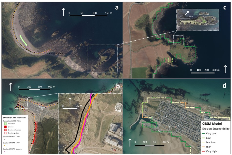
Table 3. National dataset and model evidence for coastal erosion at study sites.
Site NameCoastline TypeSite Area MappedEvidence
NCCACESMNCCACESM
BurgheadHard and mixed/artificialYesYes
  • Between 7 m and 8 m of erosion occurring on the NW side of the site between 1904 and 2011 1
  • Between 2 m and 2.5 m of erosion occurring on the NW side of the site between 1976 and 2011
  • Future erosion at site not projected

(significant future erosion indicated in proximity to Burghead; up to 22 m of erosion since 1976)
  • Categorised as Low Susceptibility on NW face of site
  • Medium Susceptibility on N face of site
  • High Susceptibility in area of artificial harbour (on W side)
DunnicaerHar and mixedNoYes-
(future accretion indicated in proximity to the stack; up to 16.5 m of accretion since 1967)
  • Extent of site not directly mapped
  • Coastline categorised as Very Low Susceptibility
Table Footer
1. Coastline data grouped under 1890, 1970 and modern MHWS (Mean High Water Spring–see Figure 5, frame (b)), but more accurate survey dates can be identified by clicking the mapped survey lines on the Dynamic Coast webpage [34].
Publisher’s Note: MDPI stays neutral with regard to jurisdictional claims in published maps and institutional affiliations.

