
Sustaining Heritage Patterns in Mining Towns of the North American West: A Historico-Geographical Approach

College of Art and Architecture, University of Idaho, 875 Perimeter Drive MS 2451, 83844-2451 Moscow, Russia
†
This author is a member of ISUF.
Heritage 2021, 4(2), 961-978; https://0-doi-org.brum.beds.ac.uk/10.3390/heritage4020052
Submission received: 14 May 2021
/
Revised: 3 June 2021
/
Accepted: 3 June 2021
/
Published: 7 June 2021
(This article belongs to the Special Issue Heritage Patterns—Representative Models)
Abstract
:Urban morphology provides essential methodologies to inform processes for heritage preservation and design intervention in historic places. Among principal research methods used by urban morphologists, the historico-geographical approach is particularly helpful for interpreting formative and transformative processes and for identifying key elements that define the physical structure of historic contexts at a town or neighbourhood scale. This article will discuss applications of an adapted historico-geographical approach to analyse heritage patterns in 19th-century mining towns located in mountainous regions of the western United States. Profiled case studies are part of an ongoing study intended to inform design and revitalization processes by architects, planners and community stakeholders in the region.
1. Introduction
Historic mining communities in the North American West that have been adapted as destinations for mountain recreation and cultural tourism are challenged with often conflicting goals to preserve their inherited mining-era contexts while accommodating growth and development interests. Citizens and civic leaders seek strategies to sustain place identity in the face of growth and change. Most community preservation efforts, as guided by architects, primarily focus on restoring or repurposing historic buildings. Underlying planning patterns that also shape inherited contexts may not be adequately understood. Urban morphology provides essential methodologies to inform processes for heritage preservation and design intervention in historic places.
Discussion is informed by studies of residual mining-era heritage patterns in towns throughout the United States (US) Mountain West using urban morphology methods. Findings are intended to contribute to a broader understanding of western mining towns as a distinct typology and, more specifically, to inform planning and preservation policies intended to sustain their mining-era place identity. Particular emphasis will be placed on three representative communities that achieved full maturity during the mining era, including Park City, Utah (UT); Telluride, Colorado (CO); and Wallace, Idaho (ID). All three towns sustained silver mining operations as their primary source of employment for at least 100 years between the 1870s and 1980s. Following mine closures during the latter half of the 20th century, each community’s revitalization plan aspired to build a future on opportunities afforded by its historic built environment and mountain setting. Strategies for economic realignment included transforming mining-era downtowns into hubs for mountain recreation, downhill skiing and cultural tourism. Capacity to preserve the integrity of mining-era contexts in the face of development has varied depending upon policy-makers’ understanding of their authentic spatial character and underlying structure.
2. Research Methods
Urban morphologists investigate the historical development of the physical components that shape built environments. These analyses are based on three guiding principles: first, urban form is constructed of three fundamental elements: buildings and their related open spaces, plots and streets; second, urban form can be understood at different levels of resolution, ranging from individual spatial elements such as building/plot configuration to their assemblies within a region; third, urban form can be understood historically [1] (pp. 3–10).
Among principal research methodologies used by urban morphologists, an historico-geographical approach as developed by geographers Jeremy Whitehand and his mentor M.R.G. Conzen, are particularly helpful when applied to analysis at the town or urban neighbourhood scales. M.R.G. Conzen’s studies of small cities and towns in the United Kingdom closely examined street systems, plot patterns and building patterns, both individually and as an ensemble, in order to interpret the spatial structure of the urban ground plan. Using methods of plan analysis, M.R.G. Conzen identified distinct periods of town development for each context. Applications of the Conzenian approach for plan analysis, as demonstrated by J.W.R. Whitehand, Michael P. Conzen and Kai Gu, provide a basis for cross-cultural comparisons of urban development in Chinese and European cities. Methods used to identify and interpret heritage patterns in mining communities represent an adaptation to the North American context [2,3]. The overall objective is to identify over-arching spatial characteristics that serve to distinguish 19th-century mining towns of the US Mountain West as a distinct town typology. The focus of the study is primarily on finding similarities in their physical form. Adaptations of Conzenian methods are required for several reasons: systems for land subdivision in the US West differ from those used in Conzen’s study towns in the United Kingdom; the relative importance of each spatial element’s contribution to the overall town plan varies between the two contexts; and resources used for town plan analysis are specific to the US context. A brief outline of the research process used for this on-going study follows.
- Plan analysis. Examination of archival territorial maps, plans, city plats and documents housed in federal, state and county collections provide valuable information regarding processes for town formation and expansion during the mining era. Founding town plans and subsequent platted additions illustrate the overall progression of formative and growth stages. A review of town plats also provides scaled information about several key elements shaping town form, including the organisation of streets, blocks and plots, and their transformation over time.
- Building uses throughout most of the mining era were recorded on color-coded fire insurance maps produced by the Sanborn Company between the mid-19th to mid-20th centuries to help underwriters assess risk. Sanborn maps, which were updated every few years until the mid-20th century, show plot dimensions, building footprints, number of stories, building use and construction materials. The practice was modelled after fire insurance underwriters in Britain who used mapping to illustrate fire risk to London buildings. It is noteworthy that urban morphologist M.R.G. Conzen and his German mentors created colour-coded maps to illustrate patterns of land utilisation, building types and number of stories [4].
- “Metsker maps” featuring Pacific Northwest townscapes as prepared by the Seattle-based company beginning in 1901, are used to support interpretation of the historic townscape in relation to natural topography and to the township and range system, a US system implemented in 1875 for land survey of the western territories. The survey system’s use of an orthogonal overlay on mountainous terrain reflects the government’s determination to impose order on a vast wilderness. Use of the grid as a strategy for land subdivision continued to dominate western settlement patterns at each scale of resolution from regional to town plan until the mid-20th century.
- Local history research. A review of local history collections housed in county libraries, historical museums and university libraries supports interpretation of socio-economic and cultural influences. Correlation of historic trends with plat sequences supports identification of transformative forces and their potential manifestations in urban form. Birdseye perspective drawings and historic photographs of downtown districts housed in archival collections enhance three-dimensional understanding of key spatial elements.
- Field documentation. The importance of field research cannot be underestimated. Although information about the physical dimensions and organisation of heritage patterns within contemporary contexts can be acquired using remote sensing tools, there are significant advantages to on-the-ground research. Immersion in the spatial environment being studied engages all the senses, enhancing an urban morphologist’s ability to perceive the impact of scale and dimensions depicted in plans and by aerial views secured by remote sensing tools.
3. Mining Town Formation
In mining communities of the Mountain West, processes for town formation typically followed a similar pattern. Initial ore discoveries attracted a rapid influx of transient prospectors and placer miners to previously unsettled mountainous regions. Fortune seekers bent on taking rather than community-making set up informal camps composed of tents and crude wooden shacks along stream beds near mineral extraction points. Entrepreneurs and opportunists followed in their wake to establish market centres in support of placer mining activities.
Early settlements often paralleled the natural course of rivers and streams, which served as natural fixation lines for town formation. During initial stages of town development, rows of simple wooden houses and false front commercial buildings were constructed on canyon floors. Emerging townscapes were typically elongated in form and confined within narrow canyon walls. A spinal main street, serving as a humanly constructed fixation line, connected extraction sites at the canyon head to the principal route leading to urban marketplaces. The earliest regional transportation routes, established by indigenous people, included ancient trails leading over mountainous terrain. In some cases, mining prospects were sufficient to motivate private landowners to construct access via toll roads capable of handling teams of oxen, as was the case in Telluride [5].
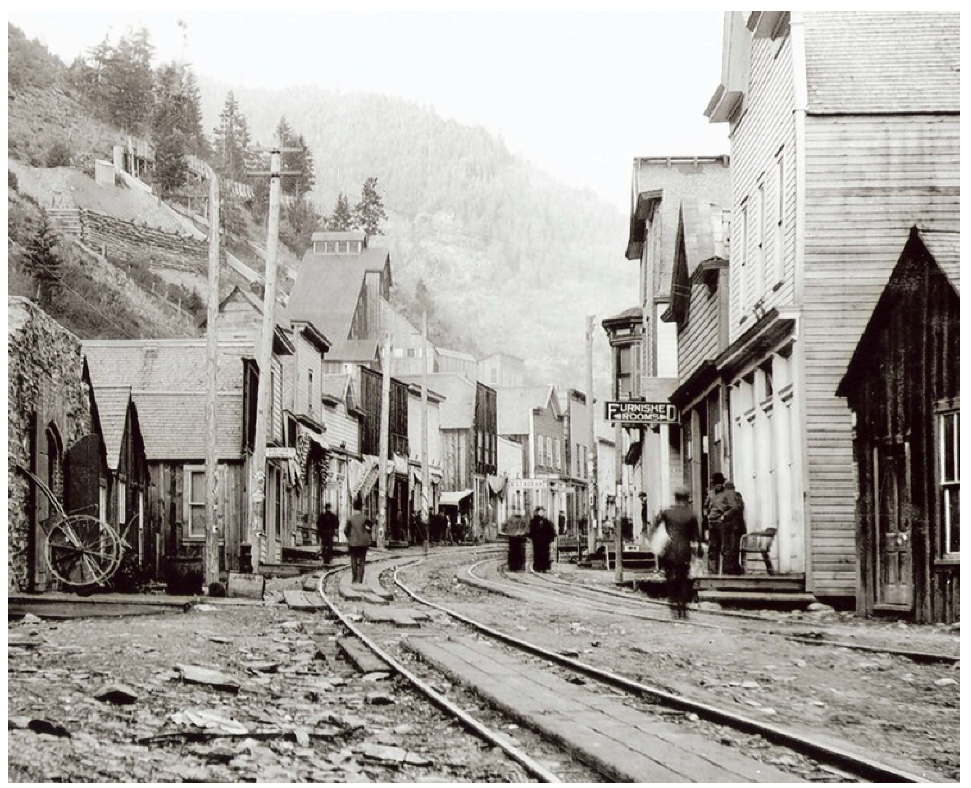
Natural geography conducive to town development was a key factor in accommodating and sustaining permanent settlement. A majority of fledgling townsites in extreme mountain settings lacked ample room for growth and expansion. Burke Idaho (ID), near Wallace in Idaho’s Coeur d’Alene Mining District, provides an example of former settlements that were shaped almost entirely by extreme geography and resource flow. In the case of Burke, the canyon floor was so narrow at 300 feet (91.4 m) across that it could only accommodate a single shared circulation corridor, including two sets of railroad tracks, flanked on each side by a mixed street wall of houses and commercial buildings. Congestion was intense, prompting old timers to joke that, to survive in Burke, dogs had to learn to wag their tails up and down instead of sideways. Burke progressed quickly from encampment stages following initial ore discoveries in 1884 to an official townsite in 1890 with over 300 stores, offices and saloons aligning its single street at its peak in 1910. Incapable of diversification, the townsite’s population gradually diminished following World War II, in tandem with slowing extraction rates and a decline in silver prices [6]. Constricted townsites such as Burke were largely abandoned once readily accessible ore reserves were exhausted. Remnant structures of fledgling communities and terrain altered by placer/surface mining activities can be found throughout the Mountain West (Figure 1).
Economic sustainability and progression to mature stages of town formation depended upon capacity to develop lode mining operations deep underground. Lode reserves attracted investment by mining corporations, providing stable employment for three to four generations. Following construction of transcontinental railroads across the Mountain West in the late-19th century, a mining community’s ability to secure rail linkage to coastal marketplaces became an essential condition for successful corporate mining operations and long-term viability (Figure 2).
4. Case Profiles
Historic background. Lode silver mining dominated the economies of Park City, UT, beginning in 1873; Telluride, CO, in 1877; and Wallace, ID, in 1886. Each community sustained corporate operations for at least a century. Corporate lode mining operations recruited waves of immigrant miners from throughout Europe and the eastern United States to work deep underground. Employment stability enabled multiple generations of miners to establish roots and engage in community-building processes in partnership with business owners, professionals and civic leaders. During early years, each townsite was accessed by mule along mountain trails or oxen teams on toll roads. Promising lode mining operations attracted railroad company investment by the 1890s. Rail service fuelled growth and prosperity by assuring expedient connection to urban markets. The combined factors of economic sustainability, railroad linkage and more favourable natural geography enabled each town to progress through characteristic stages of mining town development and to achieve full maturity during the peak of its mining era. A comparative discussion of similarities and differences in their urban form follows.
Townscape. Natural geography played a significant role in shaping each community’s distinct urban form. All three settlements were established in river canyons of varying widths, flanked by steeply sloping hills or mountains. Formative processes in each circumstance occurred within influences exerted by distinct topographical outlines acting on conventional planning concepts, defined by M.R.G. Conzen as “morphological frames” [3,4] (p. 251; pp. 103–109). Though to varying degrees, natural geographic conditions were generally favourable to growth and expansion throughout the mining era. Historic townscapes also represent a palimpsest of humanly constructed environments. According to M.R.G. Conzen, when reflecting on his own studies of towns in the United Kingdom, “historical townscapes are palimpsests, bearing the stamp of their period of origin as well as subsequent periods” [3] (p. 50).
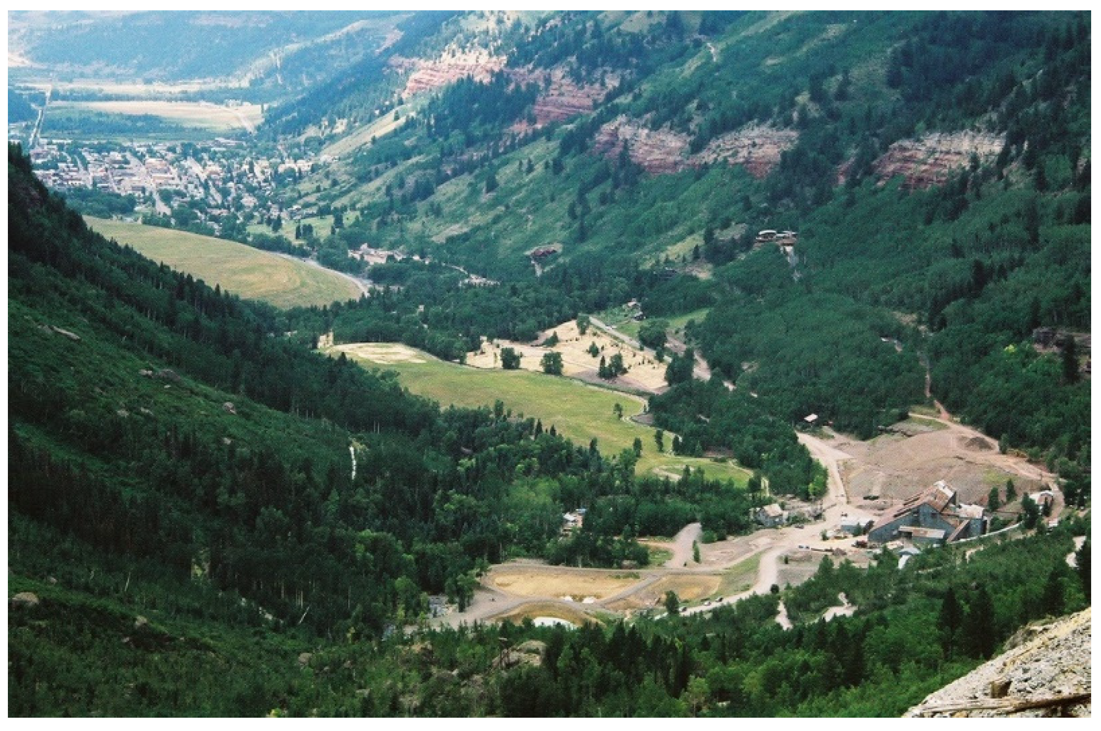
Mining townscapes also bear the indelible signature of human intervention and pollution of natural environments resulting from extraction processes, as evidenced by excavation trenches, polluted waterways, tailing deposits and treeless hillsides. Postmining clean-up often involves “capping”, a process of covering mining tailings to isolate contaminants using soil and shallow root vegetation. Environmental clean-up sites are frequently located at the historic edges of town. As shown in Figure 3, capped mining tailings in Telluride form a fringe belt of park-like but polluted, undevelopable land.
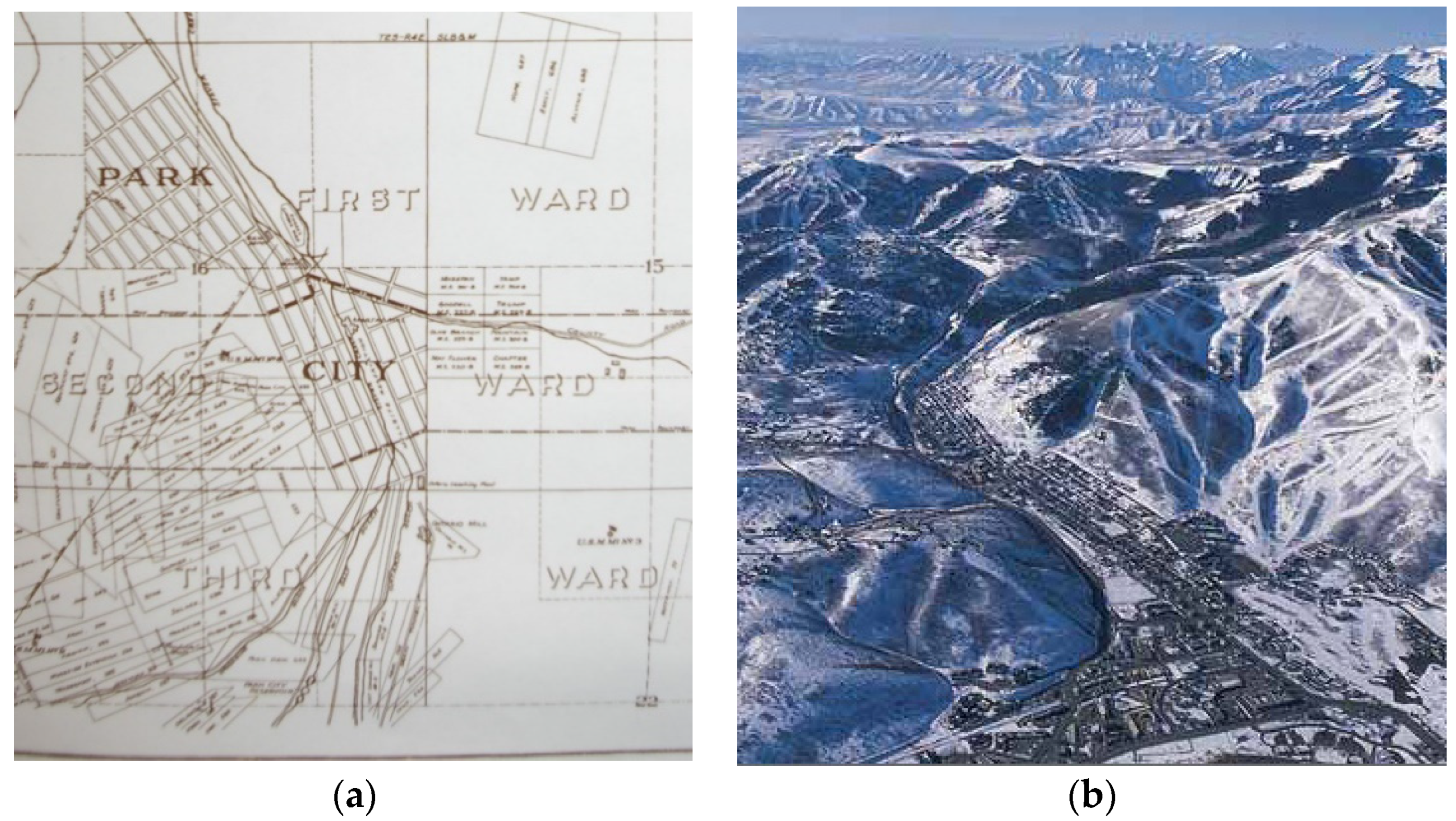
Town plan. Contrary to historic accounts depicting mining communities as spontaneous and unplanned, progression beyond encampment stages was generally guided by a deliberate town plan. The ideal mining town plan was configured as a gridded network of streets and alleys bisected by a principal commercial street. However, each orthogonal planning template, when imposed upon local terrain, manifested in a unique urban form. Park City’s town plan reflects the most severe degree of topographic constriction of the three study towns: its original plat measured less than 500 feet (152.4 m) across a sloped canyon floor and could only accommodate four paralleling streets near the canyon head; blocks are elongated, measuring 425–450 feet (129.5–137.1 m) in length and approximately 100 feet (30.48 m) in depth Figure 4a,b.
Wallace’s townscape within an ascending river valley was shaped by moderately restrictive geographic conditions. Its well-proportioned rectangular city blocks proved capable of fostering positive growth and expansion throughout the mining era. Telluride’s setting within a generously proportioned box canyon measuring 1.6-km in width accommodated a founding plat comprising equally sided blocks subdivided into narrow, regularly sized residential and commercial plots.
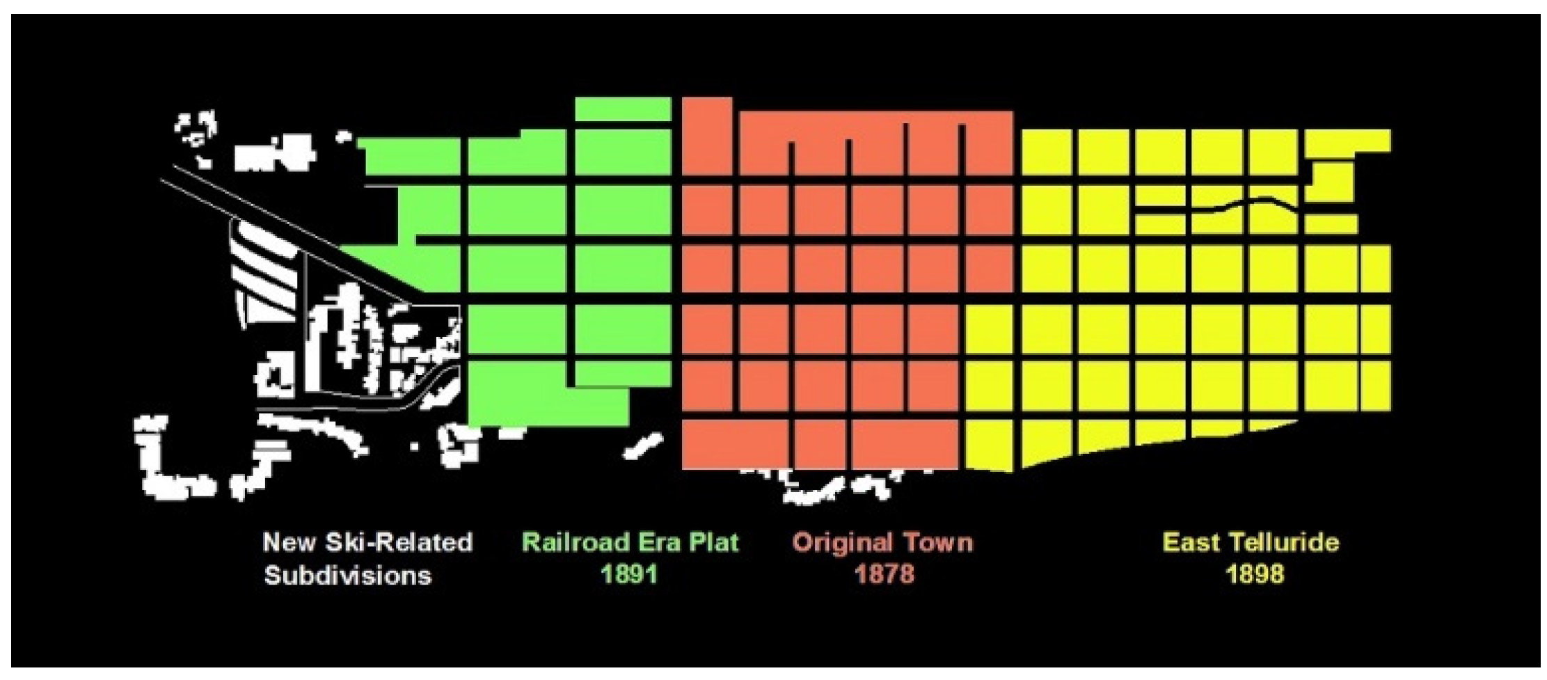
Railroad company planning influence on mining town expansion during the late-19th century is exhibited in all three settings. Telluride’s 1891 addition to the founding plat provides the clearest example. In lieu of the original plan’s equally sided blocks, planners for the Rio Grande Southern (RGS) railroad company platted rectangular blocks that are elongated in a two-to-one ratio in the direction of rail travel. The advent of rail service fuelled growth in remote mining communities such as Telluride, generating a need for developable plots. The rectangular block configuration accommodated more efficient land subdivision with less land allocated for cross streets. Blocks of the expanded town plan are subdivided into equal 25-ft × 100-ft plots (7.6 × 30.5 m), with an exclusively north–south orientation facing the tracks. The newly configured blocks increased exposure and associated land value for the RGS railroad by maximizing plot frontage along the rail corridor. Furthermore, the subtle shift in block form and plot orientation reflects the railroad corridor’s significance as a new fixation line for community development. Railroad additions to town plans characteristically remained compact, enabling walkable access to the railroad depot and to the town centre from residential neighbourhoods (Figure 5 and Figure 6).
In addition to blocks, mining town plans are primarily defined by their street networks, plot configurations and land uses. The town plan’s spatial character and scale is further defined by street cross-sections, siting of buildings in relation to street frontages and plot lines, and the unusually small scale and simplicity of common building types. An expanded discussion of each principal element follows.
Streets and Alleys. During early development stages, each side of a spinal main street was flanked by a street wall of simple wooden gable end and false front commercial buildings. Street dimensions in mining towns reflected their geographic constraints. Typically, corridor widths are narrower than other town typologies in the US Mountain West. Park City’s Main Street width is particularly narrow, at 50 feet (15 m). By contrast, Telluride’s main street, Colorado Avenue, spans approximately 80 feet (24.5 m). City founders boasted that Colorado Avenue, the city’s principal commercial street, was wide enough to enable an ox cart driver to turn his team completely around, considered a luxury in mining towns [7]. Canyon widths also determined whether secondary networks of alleys could be accommodated. Telluride, in particular, features a comprehensive system of linked 25 ft wide (7.5 m) alleys that historically provided access to carriage houses, barns and city services (Figure 7).
Plot Patterns. In general, surface land subdivision and ownership patterns in mining towns are independent of underlying mining claim ownership. Although land surveyors sought to standardize plot size, surface plot patterns vary according to limitations imposed by natural conditions. Irregularly shaped blocks in Park City are subdivided into single plot depths at the point where the canyon narrows. Rectangular blocks and plots in Wallace are sandwiched between the Coeur d’Alene River and mine entries at the face of steep mountainous terrain. Telluride’s geographic setting could better accommodate land subdivision into regularly sized plots in both commercial and residential neighbourhoods. Wherever possible, buildings in all three towns are consistently sited in relation to plot lines and street frontages serving to reinforce the legibility of plot’s boundaries (Figure 8 and Figure 9).
Buildings. The first residential and commercial buildings were constructed of wood, a readily available material. Their simple, rustic architectural character reinforced mining towns’ perceived images as “rough and rowdy” places. Sanborn maps indicate disproportionate numbers of saloons and “female housing” compared to other building typologies in early commercial centres. Store fronts historically formed a continuous street wall of simple, wooden gable end and false front single-story buildings (Figure 10).
Early residential neighbourhoods featuring simple wooden shacks developed along paralleling streets or, in cases where the canyon floor was too narrow, aligned steep hillsides above commercial centres. Since developable land was at a premium in mining towns, small-scale buildings served as a defining spatial characteristic throughout the mining era. In the cases of Wallace and Park City, rows of small miners’ houses accessed solely by staircases erupted on terrain too steep to accommodate platting of city streets. Residential neighbourhoods that developed during corporate mining years featured simplified vernacular renditions of late-19th century architectural styles. Ideally, as is the case in Telluride, gable ends were aligned parallel to the long axis of plots in a regularly spaced pattern. Maturing streetscapes conveyed a sense of stability and order compared to early settlement years (Figure 11, Figure 12 and Figure 13).
Fire as an agent of change during the mining era had the most significant impact on a community’s building typologies and materiality. While the town plan, including the organisation of blocks, streets and plots sustained devastating fires, early wooden false front commercial structures were vulnerable. In 1898, a devastating fire consumed Park City’s entire downtown and surrounding residential neighbourhoods. Rebuilding efforts were supported by donations from nearby communities, mining companies, local banks, businesses and railroad companies, which shipped in construction materials free of charge. Fearing the advent of winter, initial rebuilds were hastily constructed of local pine. Several replacement buildings, including hotels, banks and mining company offices were constructed of more substantial materials, including brick and stone. A new opera house celebrated the community’s renaissance and efforts to overcome its rowdy reputation [8]. Similarly, in 1890, a fire in Wallace levelled the district’s entire inventory of the town’s original wooden commercial buildings. A significant portion of the destroyed buildings included saloons and female boarding houses, as shown on Sanborn maps. By 1890, Wallace had become the banking and political centre of the Coeur d’Alene Mining District. Rebuilding efforts provided opportunities for stakeholders to reshape the community’s decadent image and to project a sense of permanence and prosperity associated with a rising class of corporate mine workers and managers. The introduction of rail service in 1890 supported their efforts to upgrade the local building stock by affording access to urban suppliers of fire-resistant materials. Urban architects were commissioned to design iconic new union halls and civic buildings. Former single-story wooden false-front commercial buildings were replaced with more substantial 2–4 story brick and cast-iron buildings featuring eclectic versions of popular turn-of-the-century architectural styles and detailing. The newly rebuilt commercial core miraculously survived the “Big Burn of 1910”, which consumed over 3 million acres of national forest land and multiple towns in a tri-state region of the North American West in a matter of 36 h. A majority of Wallace’s commercial centre, as reconstructed in 1890, persists today. Business owners continued to expand the commercial core with infill buildings representing simplified renditions of popular styles, including Art Deco and Art Modern, until the 1950s, when mining activities began to decline [9] (Figure 14).
Successful corporate mining operations in all three towns generated a need for a hierarchy of housing types to support a growing population of miners and their families. During peak mining years, residential neighbourhoods were segregated according to housing types, which included boarding houses for recent immigrants, simple single-story miner’s cottages and larger two-story houses for corporate managers, professionals and successful entrepreneurs. Wealthy mining company owners typically lived in the upscale neighbourhoods of major urban centres and accessed their investments via railroad, as needed.
5. Economic Transition
In the US Mountain West, mining populations peaked in the early 20th century. Fluctuations in national silver markets after World War II undermined corporate stability, leading to cycles of high unemployment and gradual out-migration. Cessation of mining operations in Telluride in the 1950s, Park City in the 1970s and Wallace in the 1980s caused local populations to plummet. Telluride and Park City became virtual “ghost towns”. In Park City and Telluride, mining-era buildings persisted in a state of preservation by neglect throughout the 1960s and 1970s, while remaining residents, motivated by strong place attachment, pursued strategies for economic revitalisation.
Mountain recreation and mining heritage became central to each community’s recovery plan. Building on mining-era heritage of downhill skiing as a necessary means of winter travel, Telluride and Park City recruited developers to construct world class ski areas. Base lift stations were located in repurposed historic neighbourhoods to encourage strong physical and economic linkages between town centres and ski areas. Beginning in the 1980s, ski industries in both communities attracted wealthy outside investment and generated booming real estate markets. Park City hosted the 2002 Winter Olympics, helping to boost its global image as a destination for winter recreation. Both towns have extended their tourist seasons by promoting summertime mountain recreation and staging outdoor music festivals and theatre performances. Most residents with a direct connection to mining heritage have been displaced by high housing costs resulting from booming real estate industries associated with mountain recreation and tourism. Stewardship of historic fabric now depends upon immigrants who are drawn to mining town ambience and planning departments charged with protecting historic fabric [10].
Economic recovery in Wallace has been more modest and dependent upon federal funding for economic realignment and environmental clean-up of widespread pollution resulting from 100 years of mining activities. Towns within the Coeur d’Alene Mining District, including Wallace, were designated as “Superfund” sites by the federal government following mine closures in 1983 rendering them eligible for federal funding to finance environmental clean-up and economic restructuring. Sited along a major federal transcontinental highway, Wallace is located 11 miles (18 km) from Kellogg, ID, another recovering mining town in the Coeur d’Alene Mining District, which received federal funding to upgrade its ski area and construct a gondola base lift in town with easy access to the highway. Given its close proximity to Kellogg and its authentically preserved mining-era context, Wallace’s city plan reinforces regional aspirations to become a destination for downhill skiing, outdoor recreation and cultural tourism. Wallace also benefits directly from the conversion of an abandoned Union Pacific and Northern Pacific rail line that was historically used to transport mining ore and passengers to the city of Spokane Washington. The 73-mile (117.5 km) scenic recreational bike trail links Wallace’s historic town centre and other mining heritage sites as it follows the shorelines of natural rivers and lakes in the Coeur d’Alene River basin and Lake Coeur d’Alene. The trail bed, itself, represents a creative solution for environmental clean-up by sealing mine waste rock containing heavy metal pollutants and spillage under a bed of thick asphalt and gravel [11].
6. Stewarding Mining-Era Heritage in the Postmining Era
Community capacity to steward mining-era contexts has seen varying degrees of success depending upon policies regulating development. While none of the profiled towns have explicitly adopted a regulatory approach based on urban morphology, design guidelines enacted in Wallace and Telluride reflect a clearer understanding of key mining heritage patterns. A comparative summary of development regulations for each context follows.
The Wallace community successfully averted the complete destruction of its historic core by the federal highway department, which planned to construct a four-lane, high-speed segment of its transcontinental highway directly through downtown. Local preservation advocates, who sustained close ties with mining era culture and place identity, pursued designation of the entire town as a national historic district. Leverage afforded by the National Historic Preservation Act and community solidarity forced the Federal Highway Department to construct an elevated bypass on the district’s northern edge, thus sparing mining-era heritage (Figure 15).
In 1987, the Wallace city council instituted design guidelines for restoration, alteration and new construction within the town’s historic districts, which require certification by the historic preservation commission for project appropriateness. The guidelines, which primarily regulate architectural design, focus on reinforcing key elements of mining-era scale and form by limiting building height, size and massing of new construction to within 10 percent of existing buildings. “Site orientation, proportion and directional expression” are also regulated to conform to established mining-era patterns. Given the community’s strong commitment to sustaining its mining heritage, Wallace persists as one of the most intact mining-era streetscapes in the Mountain West [12].
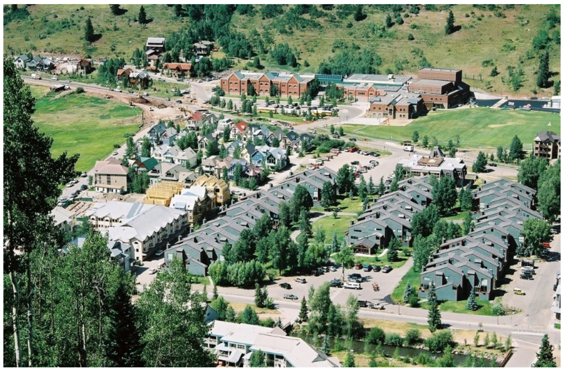
Park City is on the verge of losing its mining town identity, entirely, under the pressure of a robust real estate market. “Old Town”, Park City’s historic commercial centre, was designated as two national historic districts in 1978. Maintaining the city’s historic identity is a stated goal in the “General Plans” implemented in 1985 and 1993. Both plans were based on vague interpretations of what “historic image, imagined or real” that the city supported, whether mining, rural ranching or mountain resort. Their inherent ambiguity is captured in the 1993 General Plan’s introduction, which states “the features of community character are difficult to define with precision” [13]. Park City’s “2014 General Plan” exhibits citizen appreciation for mining heritage and a renewed commitment to promoting a “cultural sense of place” [14]. Although individual buildings along several blocks of “Old Town’s” main commercial street have been artfully restored, upscale resort development continues to transform mining-era streetscapes. While aspirational, the plan lacks adequate language to identify signature elements of mining heritage planning patterns and scale to help guide development. For example, Park City’s Main Street, sited in a sloped canyon base, was historically framed by descending street walls and rooflines of two-story buildings. Development guidelines recognize this important characteristic of mining-era form; however, recently constructed tourist accommodations offset its legibility with taller buildings (Figure 16).
Mining-era houses along paralleling streets are overwhelmed by ski-related development. In some cases, facades of demolished mining-era cottages have been incorporated into large condominium complexes. New infill buildings dwarf adjacent miner’s cottages. Townscape edges, which were historically defined by canyon walls and open hillsides, are losing legibility due to encroachment of new residential neighbourhoods featuring voluminous vacation homes sited on large plots along cul-de-sac streets. The intimate scale and clarity of mining-era heritage patterns is overwhelmed and obscured by suburban style form (Figure 17).
Telluride, which also boasts a robust real estate market, has been more successful at preserving heritage patterns. In 1963, Telluride was granted national landmark status, which offers the highest level of federal recognition for historic places. Landmark designation paved the way to implement more comprehensive guidelines and standards to regulate development. The community’s ability to preserve the clarity of mining-era form is enhanced, because development guidelines acknowledge the critical role that historic planning patterns play in defining place identity. They seek to protect the legibility of key elements of the town’s plan, including the grid configuration of streets, blocks and alleys and building orientation on both plots and blocks.
Telluride’s guidelines mandate that new infill construction and additions to historic buildings reinforce mining-era scale, a defining spatial characteristic. Additions to mining-era buildings are regulated to minimise volume and visibility from the street. Given the intense real estate development pressure in Telluride, coupled with an American proclivity towards building large second homes in resort areas, the guidelines have been remarkably effective in stewarding mining-era scale by preventing new construction from overwhelming the town’s intimate, late-19th century ambience. New infill construction is required to reinforce existing neighbourhood patterns for building placement and orientation. As illustrated in Figure 18, new single- and multifamily infill housing feature prominent, regularly spaced gable ends and recessed connectors, which help to reinforce streetscape patterns. Cross-gable rooflines increase square footage and volume while reducing the impact of larger building footprints.
Most US cities and towns, including Park City and Wallace, have adopted Euclidian Zoning, a US system for conventional land use regulation that was introduced in 1926. Euclidian Zoning regulates development by dividing a town into districts according to allowable and prohibited land uses. The system has significant limitations as a planning strategy, particularly when used as the primary tool to regulate development in historic places such as 19th-century mining towns where a diversity of land uses and building typologies have traditionally contributed to their place identity. Telluride’s design guidelines, as drafted by the planning firm Winter and Company, incorporate concepts to regulate physical form. Historic building typologies serve as the primary basis for determining the scale and massing of allowable development instead of their intended use. Telluride’s policies represent an adapted version of a form-based code, a planning approach first developed by the architectural firm Duany/Plater-Zyberk. Form-based codes use a regulating plan to prescribe the massing and scale of buildings, their relationships to one another and to the public street. In the case of Telluride, a regulating master plan divides the town into “treatment areas”, each representing neighbourhoods with distinct mining-era spatial characteristics and building typologies. Each treatment area is assigned allowable uses that are compatible with the predominant urban form. Guidelines for each treatment area are tailored to protect defining historic patterns and require new infill development to reinforce them [15,16]. The guidelines in some treatment areas have proven effective in addressing transformative pressures exerted by the downhill ski industry and tourism and less effective in others. The “warehouse treatment area” historically featured a mix of warehouses associated with the railroad, industrial buildings, miner’s cribs and boarding houses. Given the warehouse district’s diverse heritage of building typologies in both form and scale, regulating guidelines afford flexibility to accommodate a variety of infill development uses and building types. Larger footprint multifamily condominiums and hotels in the form of “warehouses for tourists”, modelled after industrial and boarding house precedents, have been successfully integrated (Figure 19).
A breakdown in historic continuity occurs in the “Accommodations Treatment Area”, which houses large-scale ski-oriented multifamily developments at the edge of historic residential neighbourhoods. Although guidelines encourage preserving “the ghost of a street grid” in new treatment areas, its legibility is obscured by bands of development, which lack a sense of visual continuity or physical connection to the town’s historic street grid when viewed from the canyon walls and base [17] (Figure 20).
Reliance on partial historic precedents such as the “ghost of a street grid” or building typologies to guide planning policy in new development areas has proven to be inadequate to sustain historic continuity in Telluride. To address the reality of incompatible development, M.R.G. Conzen’s concept of “plan-units” could be useful for planners and policy makers as a basis for codification. As defined by M.R.G. Conzen, a plan-unit represents any part of a town’s plan that is morphologically different from its surroundings as defined by its plan elements, including streets, plots and buildings. Although Conzen’s intention as a geographer was to identify existing areas within a town’s plan that are morphologically distinct, the concept of plan-units could potentially be applied as a basis for prescribing new urban form. As an organisational strategy for additions to an historic town plan, plan-units can be customized to include specifications for street systems, orientation on plots and connectivity within the overall town plan. Use of planning concepts to shape the ground plan in new development areas of historic places that are based on a deeper, structural understanding of inherited patterns have the potential to yield more complex, complete and compatible additions to the inherited town plan [3,18,19,20].
7. Conclusions
Mining-era heritage patterns in profiled towns, as well as those in a majority of historic towns in the US Mountain West that have been adapted for recreational economies, remain at risk. Booming real estate markets continue to attract waves of fortune seekers in the form of land speculators and wild cat developers bent on exploiting natural and cultural resources. Community building processes are also supported by citizens, civic leaders and entrepreneurs who take a longer-term view of inherited resources. While a majority of community stakeholders no longer contain a direct link to mining culture, many appreciate mining town ambience and associated strong sense of place identity. Mining town conservation, while well-intentioned, is hampered by policies that fail to address key defining characteristics.
The following investigative questions can support processes for morphological analysis of historic contexts as a first step towards crafting more effective policies:
- How does natural geography help to shape the townscape?
- How do changes in archival plat sequences correspond to socioeconomic changes as revealed in local history collections?
- What fixation lines, both natural and humanly constructed, historically guided town formation and transformation?
- What are key elements and dimensions of the town plan? Examples include street configurations, blocks and plot patterns.
- How can new infill development reinforce legibility of heritage patterns at the neighbourhood scale?
- How can historic building typologies and their spatial relationships serve to inform a form-based approach to planning?
- How can clarity of inherited urban form, such as city edges, density and connectivity, be preserved in the face of new development?
Applications of urban morphology methods to interpret heritage patterns in mining towns may also be of use to policy makers in other historic places. Use of an historico-geographical approach provides a more holistic view of key contributing elements that define inherited fabric. As a basis to guide regulating policy development and revitalization processes, urban morphology methods can enhance community capacity to sustain historic continuity by helping to identify signature heritage patterns that define “place”.
Funding
This research received no external funding.
Institutional Review Board Statement
Not applicable.
Informed Consent Statement
Not applicable.
Data Availability Statement
Not applicable.
Conflicts of Interest
The author declares no conflict of interest.
References
- Moudon, A.V. Urban Morphology as an Emerging Interdisciplinary Field. Urban Morphol. 1997, 1, 3–10. [Google Scholar]
- Samuels, I. Research and Practice. In J.W.R. Whitehand and the Historico-Geographical Approach to Urban Morphology, 1st ed.; Oliveira, V., Ed.; Springer: Cham, Switzerland, 2019; pp. 115–138. [Google Scholar]
- Conzen, M.R.G. Urban Morphology: A Geographical Approach. In Thinking about Urban Form: Papers on Urban Morphology 1932–1998, 1st ed.; Conzen, M.P., Ed.; Peter Lang: Bern, Switzerland, 2004; pp. 47–59, 251–253. [Google Scholar]
- Whitehand, J.W.R. British Urban Morphology: The Conzenian Tradition. Urban Morphol. 2001, 5, 103–109. [Google Scholar]
- Fetter, R.; Fetter, S. Telluride: From Pick to Powder, 1st ed.; Caxton Press: Caldwell, NJ, USA, 1979; pp. 24–26. [Google Scholar]
- Western Mining History. Available online: https://westernmininghistory.com/towns/idaho/burke/ (accessed on 20 April 2021).
- Colman, R.; McCoy, D. The R.G.’s Story Volume II: Telluride, Pandora and the Mines Above, 1st ed.; Sundance Publications Limited: Denver, CO, USA, 1991; pp. 23–43. [Google Scholar]
- Thompson, G.A.; Buck, F. Treasure Mountain Home: Park City Revisited, 2nd ed.; Dream Garden Press: Salt Lake City, UT, USA, 1993; pp. 81–136. [Google Scholar]
- Nelson, I.; Hart, P. “Wallace Historic District”, [Wallace, Idaho], SAH Archipedia; UVaP: Charlottesville, VA, USA, 2012; Available online: http://sah-archipedia.org/buildings.org/buildings/ID-01-079-0004 (accessed on 12 March 2021).
- Warren, L. Park City: Mountain of Treasure, 1st ed.; Mountain Sport Press: Boulder, CO, USA, 2003; pp. 64–168. [Google Scholar]
- McClure, W.R. “Trail of the Coeur d’Alenes”, [Plummer, Idaho], SAH Archipedia; UVaP: Charlottesville, VA, USA, 2012; Available online: http://sah-archipedia.org/buildings/ID-01-088-0002 (accessed on 17 April 2021).
- Chapter 8. Design Guidelines and Standards. Available online: https://codelibrary.amlegal.com/codes/wallaceid/latest/wallace_id/0-0-0-3826 (accessed on 6 April 2021).
- Historic Character Goals. Available online: https://www.parkcity.org/home/showpublisheddocument/12384/635724909559570000 (accessed on 21 April 2021).
- Planning Department Park City Municipal Corporation. Park City General Plan Volume 1 Goals and Strategies; Park City Planning Department: Park City, UT, USA, 2014; pp. 104–116. Available online: https://www.parkcity.org/home/showpublisheddocument?id=12370 (accessed on 22 April 2021).
- Winter & Company; The Telluride Community. Design Guidelines for Building in Telluride, 1st ed.; Winter and Company: Boulder, CO, USA, 1997; pp. WC1–WC8. [Google Scholar]
- Parolek, D.; Parolek, K.; Crawford, P. Form-Based Codes: A Guide for Planners, Urban Designers, Municipalities, and Developers; John Wiley and Sons: Hoboken, NJ, USA, 2008; pp. 3–27. [Google Scholar]
- McClure, W. Sustaining Place-Identity in Historic Mining Cities of the US Rocky Mountain West. Int. J. Des. Nat. Ecodyn. 2013, 8, 287–299. [Google Scholar] [CrossRef] [Green Version]
- Whitehand, J.W.R.; Conzen, M.P.; Gu, K. Plan-analysis of Historical Cities: A Sino-European Comparison. Urban Morphol. 2016, 20, 139–158. [Google Scholar]
- Oliveira, V.; Yaygin, M.A. The Concept of Morphological Region: Developments and Prospects. Urban Morphol. 2020, 24, 35–52. [Google Scholar]
- Whitehand, J.W.R.; Gu, K. Conserving Urban Landscape Heritage: A Geographical Approach-ScienceDirect. Procedia-Soc. Behav. Sci. 2010, 2, 6948–6953. [Google Scholar] [CrossRef] [Green Version]
Figure 1.
Main street Burke. Mining towns sited in narrow canyons were unsustainable after the ore ran out (Wikimedia Foundation).
Figure 1.
Main street Burke. Mining towns sited in narrow canyons were unsustainable after the ore ran out (Wikimedia Foundation).

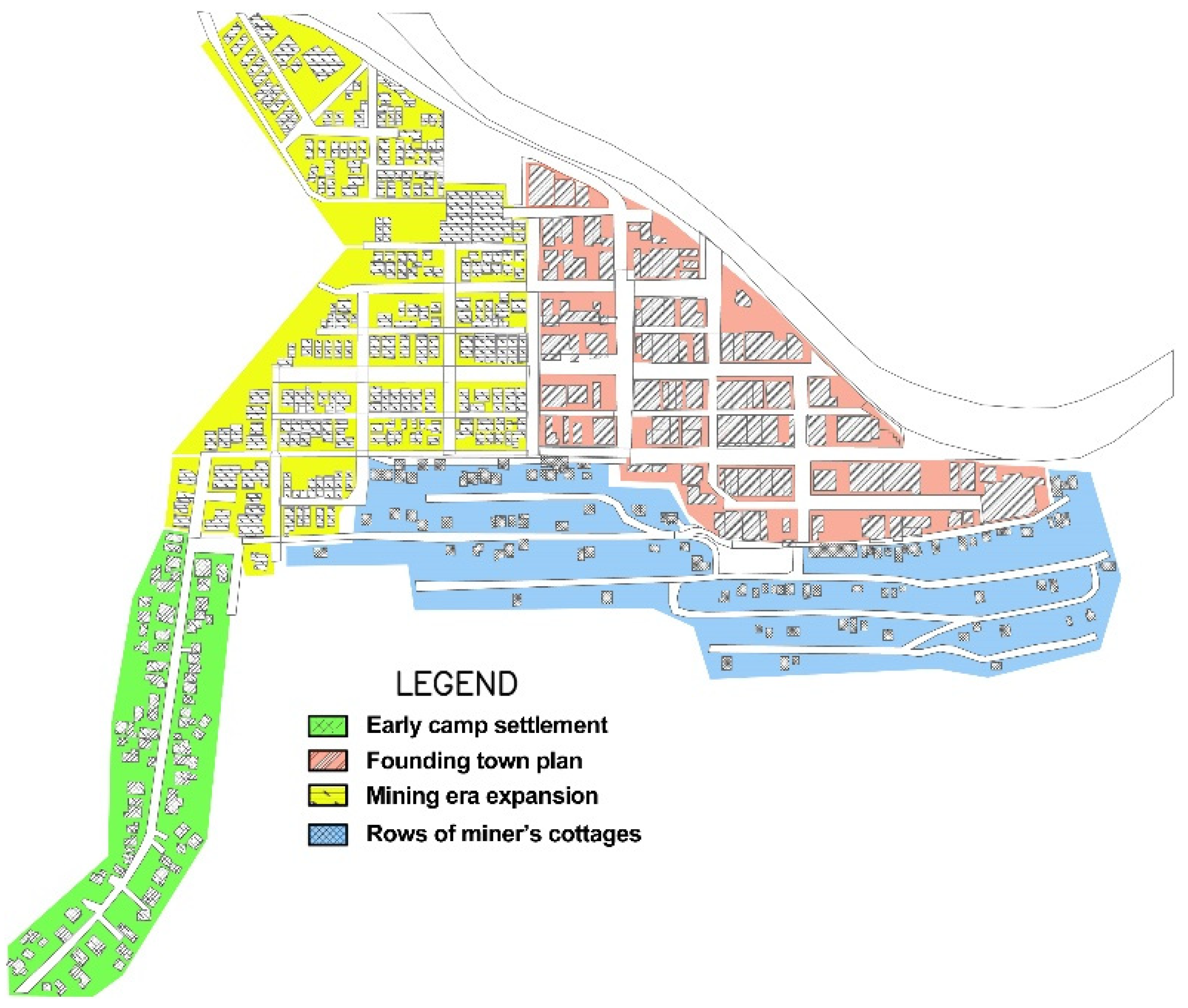
Figure 2.
Town formation stages in Wallace. Early camp (green), founding town plat (red), miner’s cottage rows (blue) and mining-era expansion (yellow).
Figure 2.
Town formation stages in Wallace. Early camp (green), founding town plat (red), miner’s cottage rows (blue) and mining-era expansion (yellow).

Figure 3.
Town edges in Telluride. Remnants of corporate mining operations and capped mining-era pollution continue to form town edges.
Figure 3.
Town edges in Telluride. Remnants of corporate mining operations and capped mining-era pollution continue to form town edges.

Figure 4.
(a) Early plat of Park City. Street and block system conforms to canyon floor (courtesy of Summit County). (b) Aerial view of Park City showing mining era townscape and contemporary sprawl (courtesy of Robert Bruce).
Figure 4.
(a) Early plat of Park City. Street and block system conforms to canyon floor (courtesy of Summit County). (b) Aerial view of Park City showing mining era townscape and contemporary sprawl (courtesy of Robert Bruce).

Figure 5.
Plat sequence of Telluride. Mining era’s original 1878 plat, 1891 railroad addition, 1898 East Telluride addition and discontinuous contemporary development.
Figure 5.
Plat sequence of Telluride. Mining era’s original 1878 plat, 1891 railroad addition, 1898 East Telluride addition and discontinuous contemporary development.

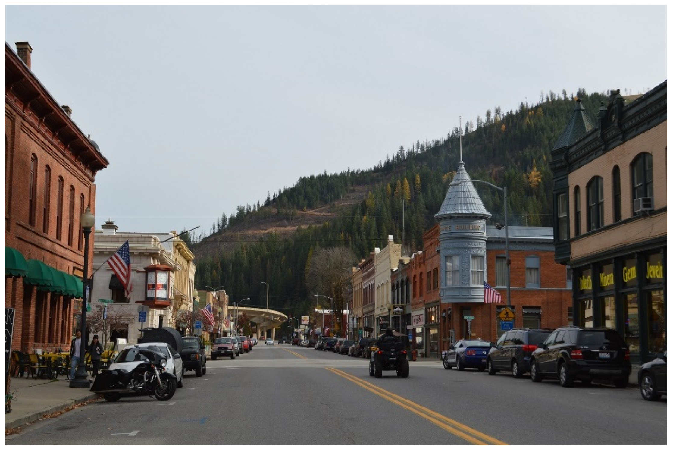
Figure 6.
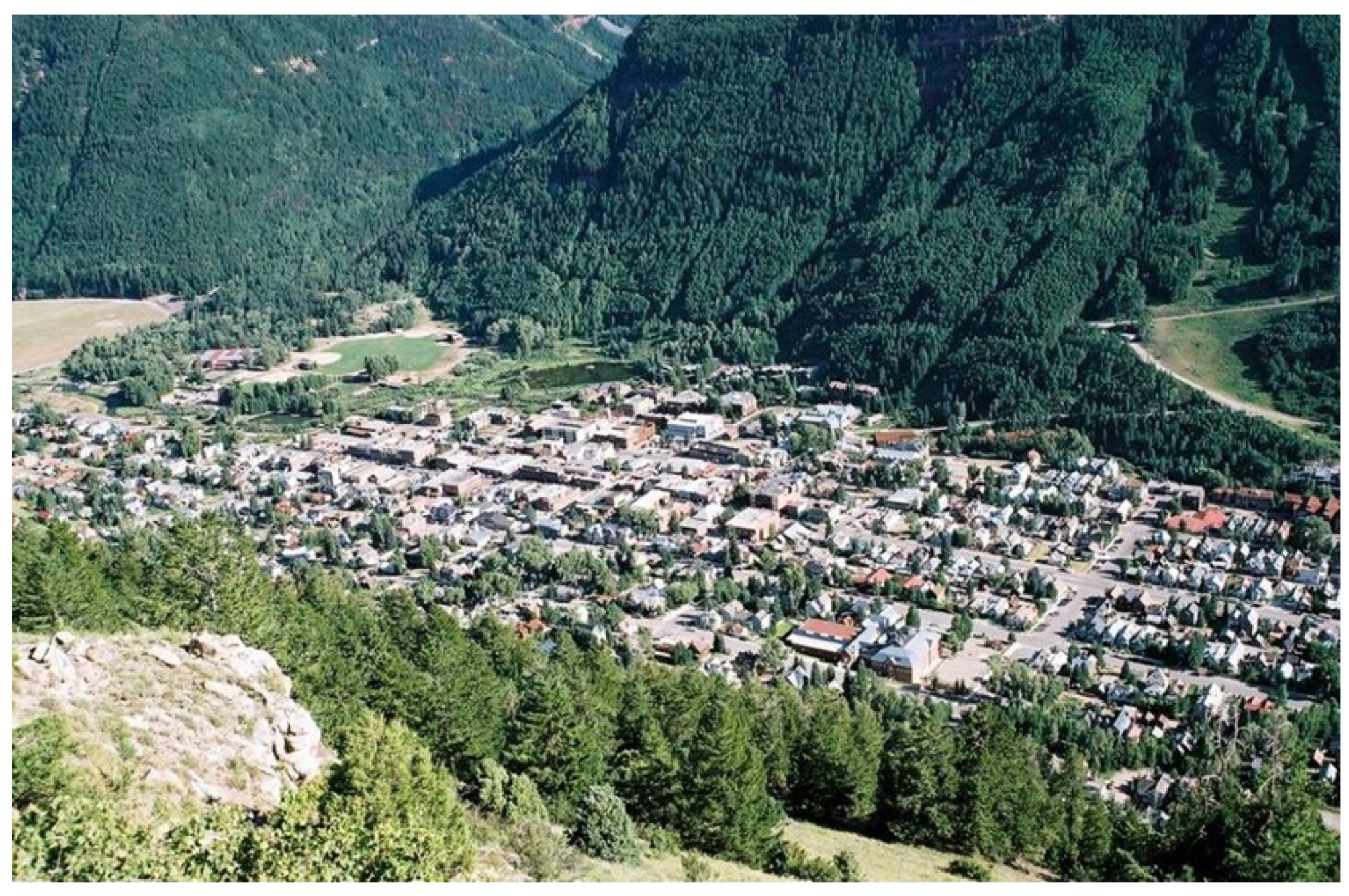
Town view of Telluride. Mining-era heritage patterns, including streets, blocks, plots and building orientation retain legibility.
Figure 6.
Town view of Telluride. Mining-era heritage patterns, including streets, blocks, plots and building orientation retain legibility.

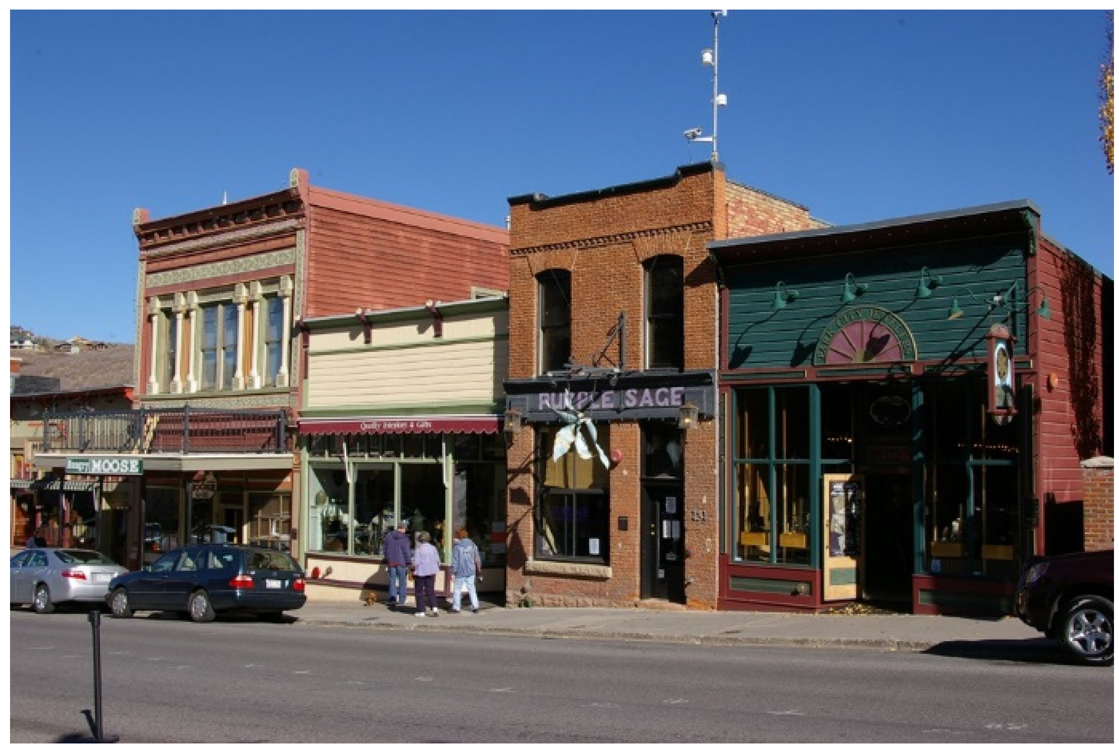
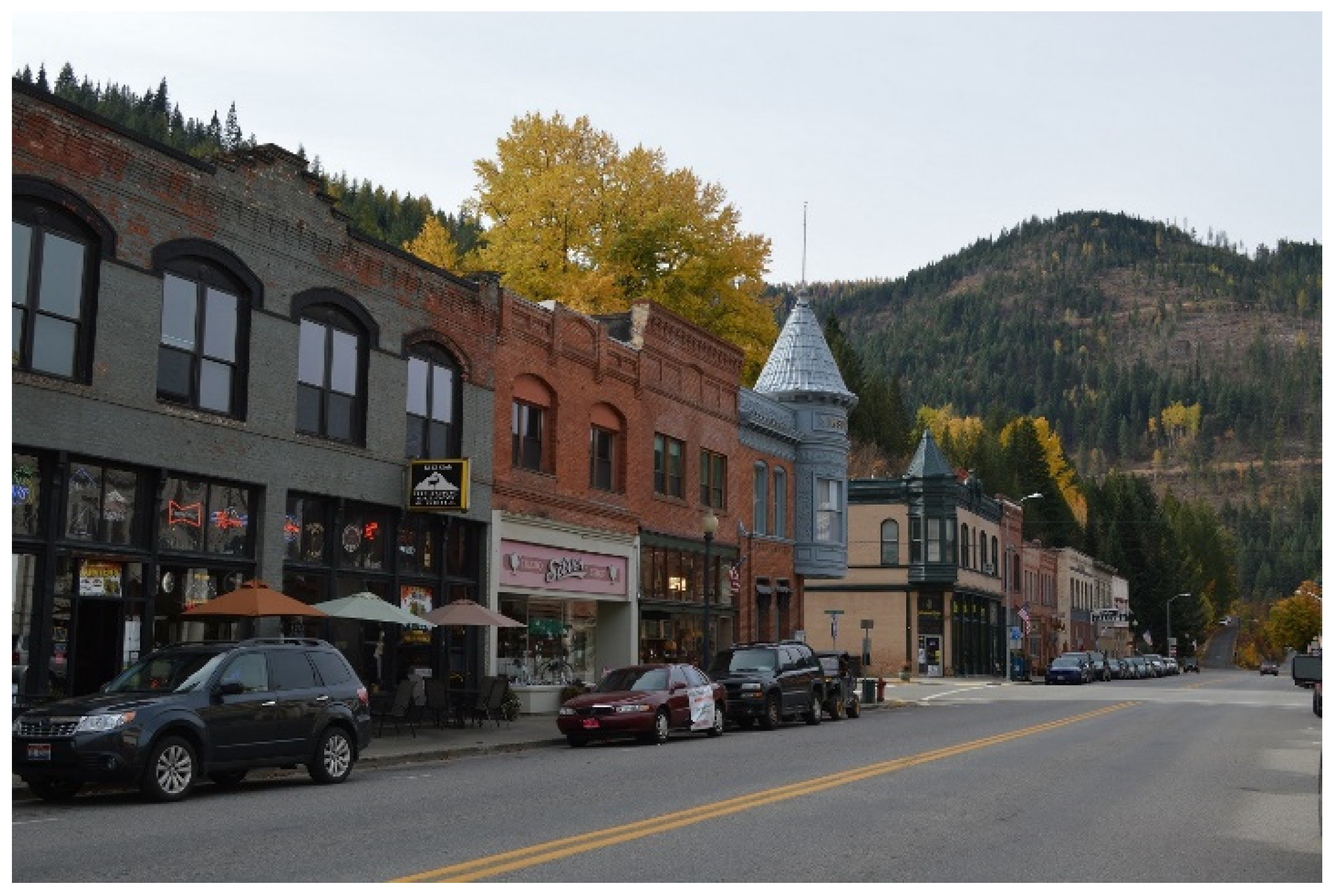
Figure 7.
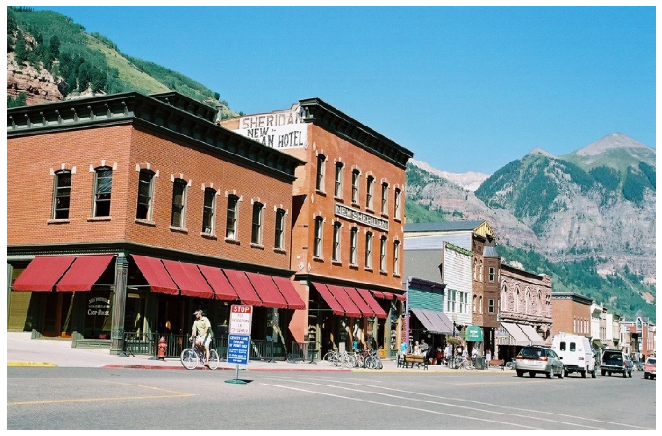
Colorado Avenue in downtown Telluride. Colorado Avenue once supported the flow of miners and wagon loads of extracted ore. Today, the street connects recreationalists to surrounding mountains.
Figure 7.
Colorado Avenue in downtown Telluride. Colorado Avenue once supported the flow of miners and wagon loads of extracted ore. Today, the street connects recreationalists to surrounding mountains.

Figure 8.
Early residential area in Park City. Sanborn map showing irregular plot boundaries and miner’s cabins above the canyon floor. (Library of Congress digital collection).
Figure 8.
Early residential area in Park City. Sanborn map showing irregular plot boundaries and miner’s cabins above the canyon floor. (Library of Congress digital collection).

Figure 9.
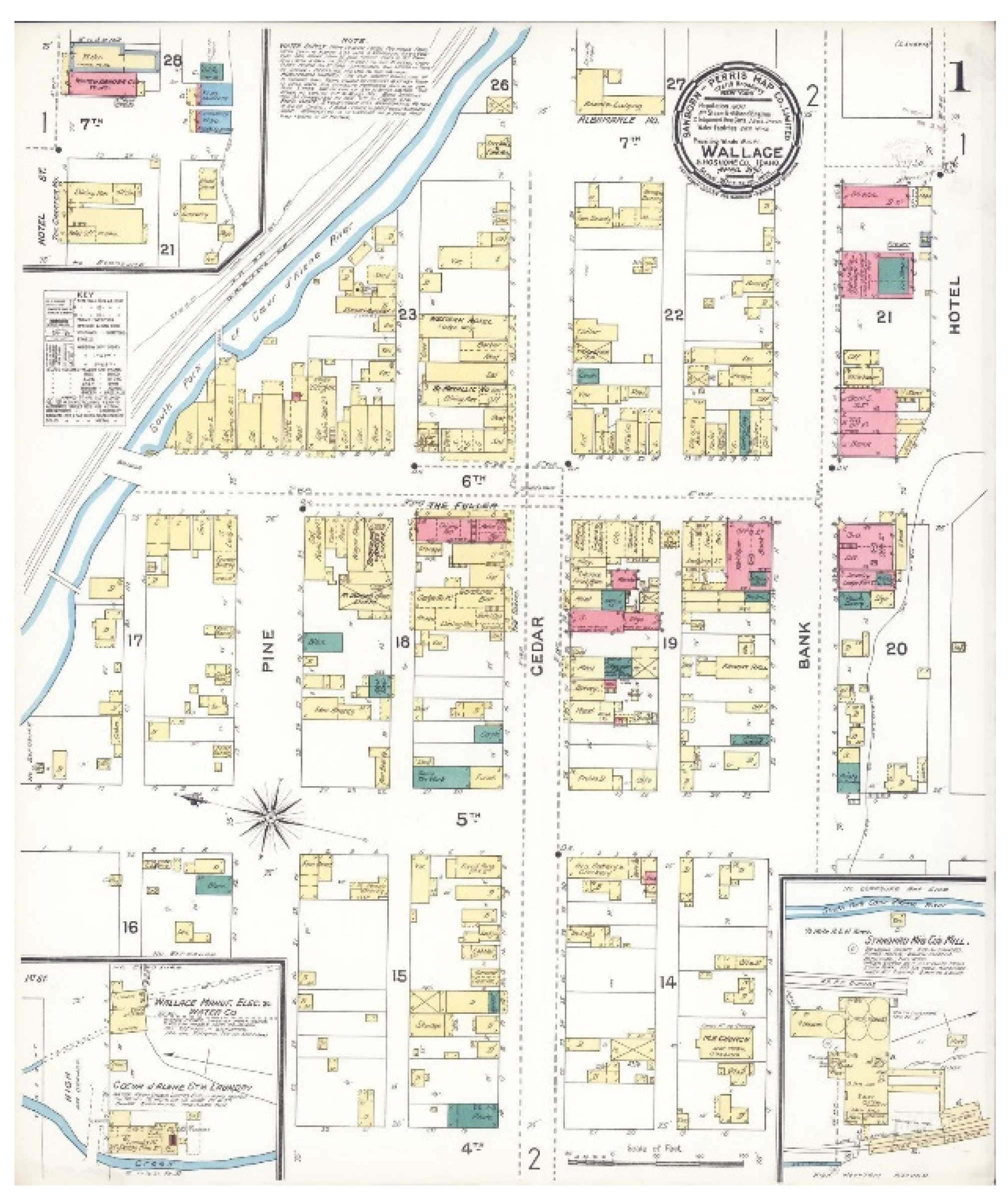
1898 Sanborn map of Wallace. Wallace’s blocks were rectangular and paralleled the course of Coeur d’Alene river and mountainous town edges (Library of Congress digital collection).
Figure 9.
1898 Sanborn map of Wallace. Wallace’s blocks were rectangular and paralleled the course of Coeur d’Alene river and mountainous town edges (Library of Congress digital collection).

Figure 10.
Restored 19th-century wood false front facades along Main Street in “Old Town”, Park City.
Figure 10.
Restored 19th-century wood false front facades along Main Street in “Old Town”, Park City.

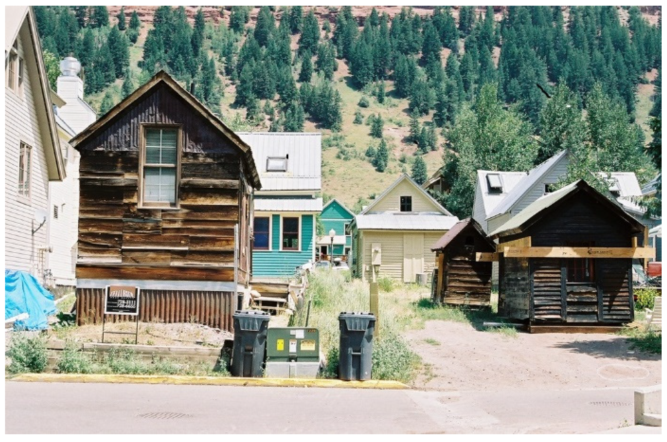
Figure 11.
Early single-room miner’s shacks in Telluride were small in scale and randomly placed on plots.
Figure 11.
Early single-room miner’s shacks in Telluride were small in scale and randomly placed on plots.

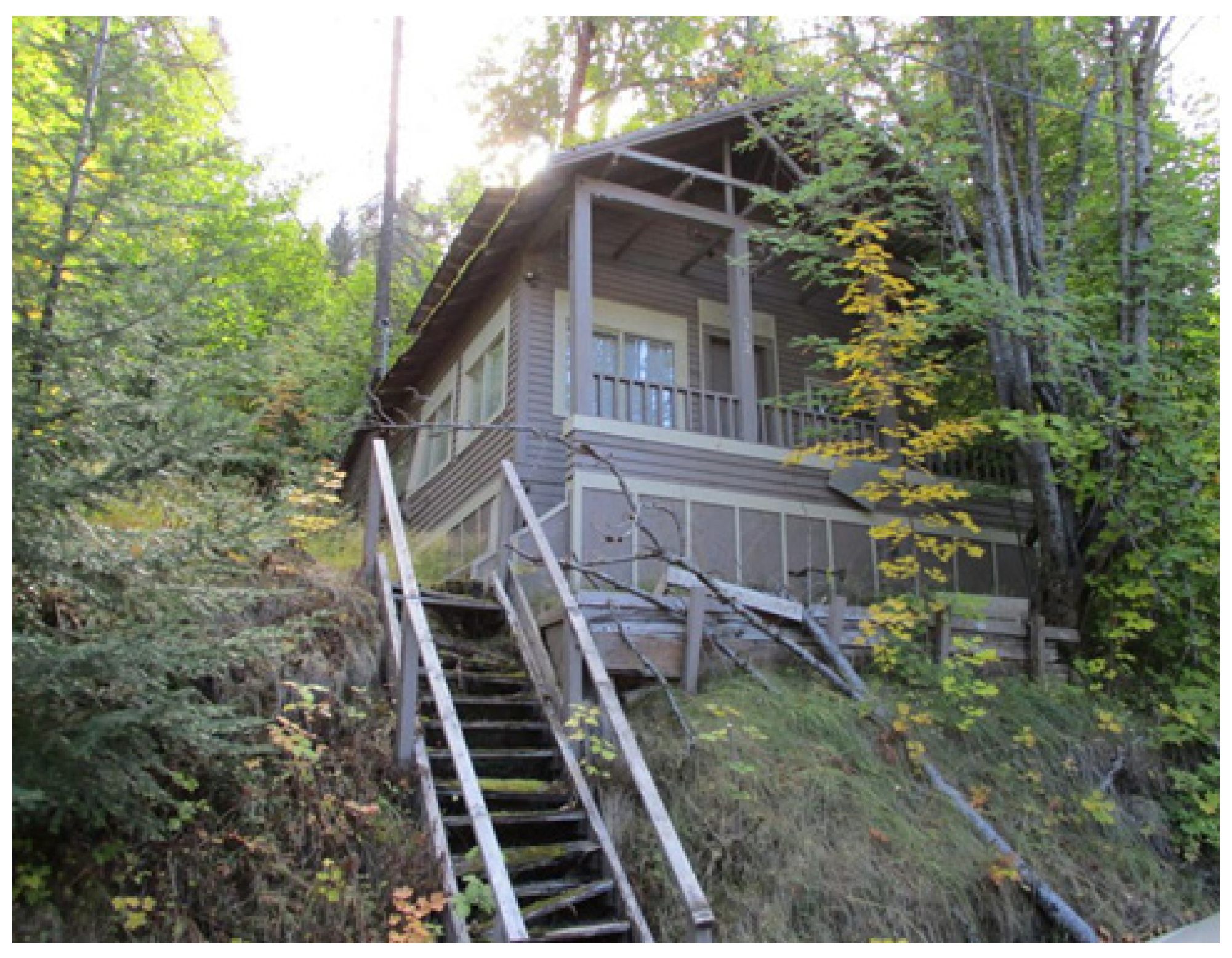
Figure 12.
Miner’s cottage in Wallace constructed directly above downtown on terrain too steep for street access.
Figure 12.
Miner’s cottage in Wallace constructed directly above downtown on terrain too steep for street access.

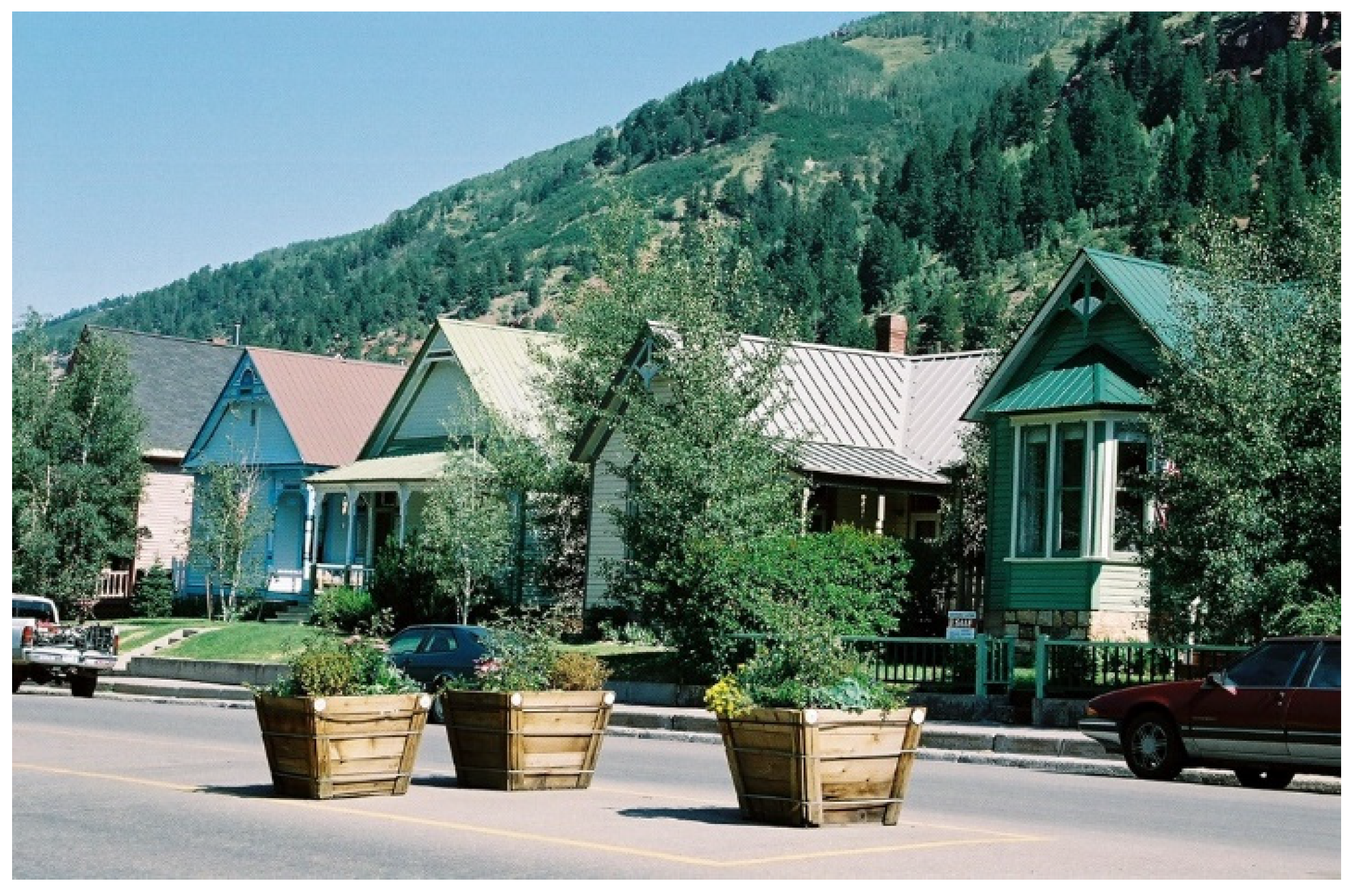
Figure 13.
Corporate mining-era housing in Telluride. Miner’s cottages were small in scale, regularly spaced and sited with gable ends facing the street.
Figure 13.
Corporate mining-era housing in Telluride. Miner’s cottages were small in scale, regularly spaced and sited with gable ends facing the street.

Figure 14.
Intact mining-era streetscape. Wallace’s 1890s downtown survived the “Big Burn” of 1910.

Figure 15.
Wallace’s preservation success story. Local preservation efforts prevented demolition of the entire historic core for a 4-lane federal highway. The elevated highway bypass can be viewed in the distance.
Figure 15.
Wallace’s preservation success story. Local preservation efforts prevented demolition of the entire historic core for a 4-lane federal highway. The elevated highway bypass can be viewed in the distance.

Figure 16.
New infill along Main Street in Park City. Construction of tall infill buildings offsets historic perception of the descending MainStreet.
Figure 16.
New infill along Main Street in Park City. Construction of tall infill buildings offsets historic perception of the descending MainStreet.

Figure 17.
Park City townscape. Sprawling, suburban style development obscures former mining town edges.
Figure 17.
Park City townscape. Sprawling, suburban style development obscures former mining town edges.

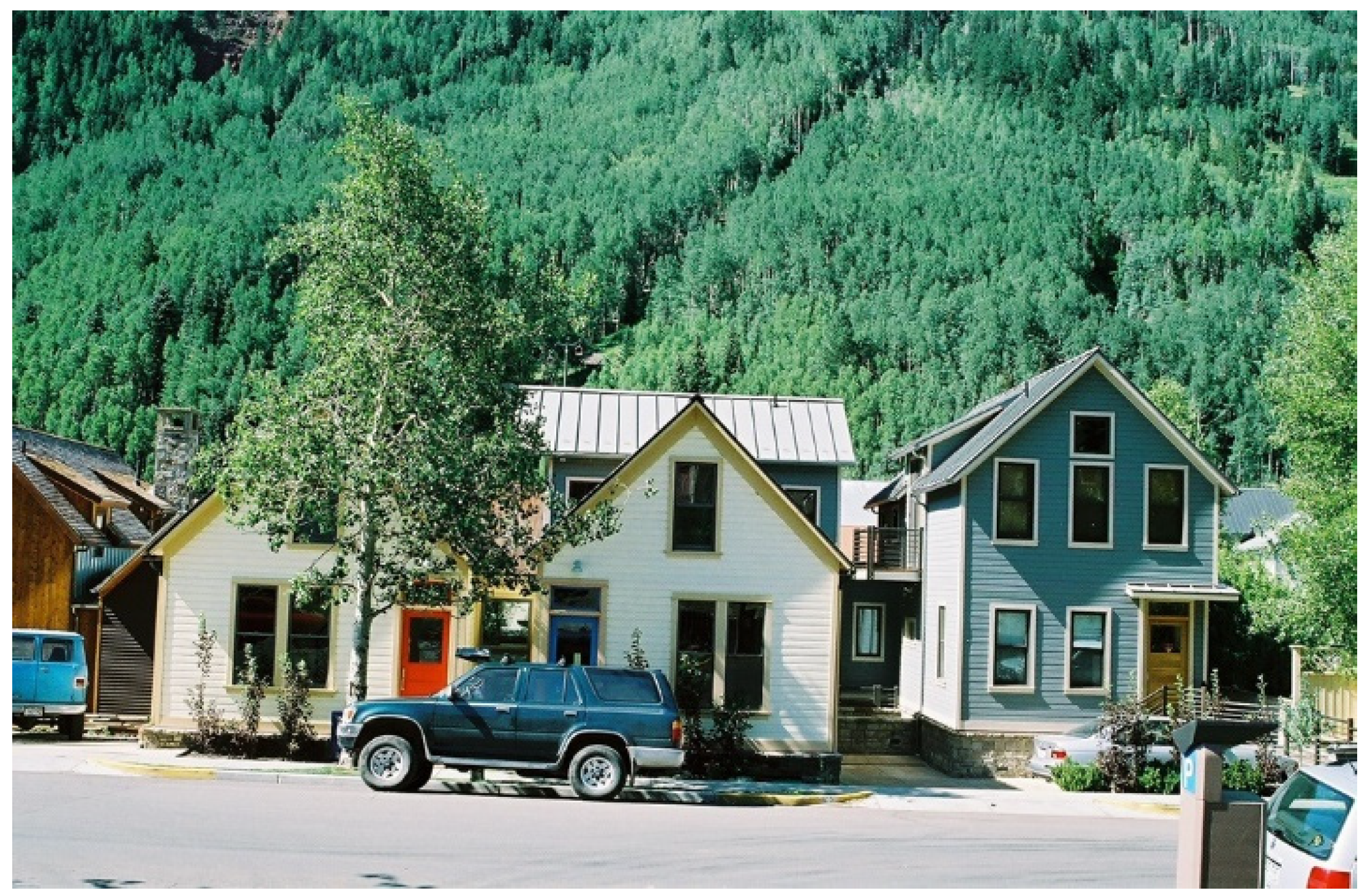
Figure 18.
New housing in Telluride. Design guidelines require perceived conformity to mining-era scale, building orientation and spacing.
Figure 18.
New housing in Telluride. Design guidelines require perceived conformity to mining-era scale, building orientation and spacing.

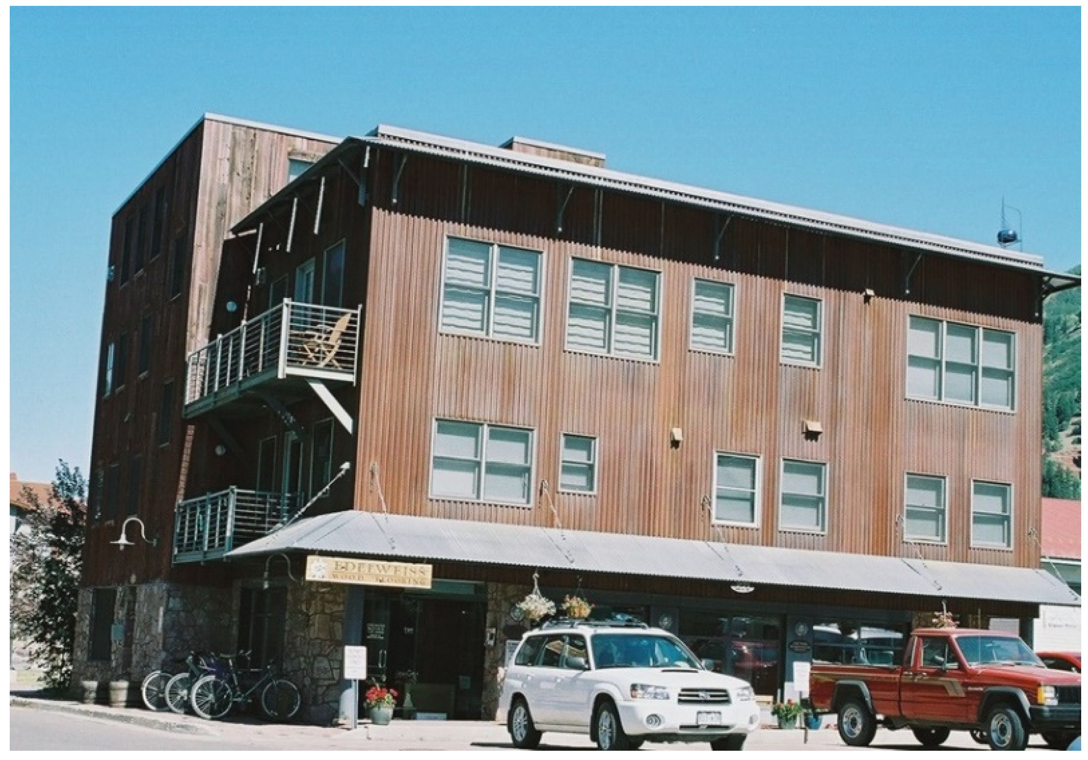
Figure 19.
New multifamily building in Telluride. Successful integration of larger footprint tourist accommodations and multifamily housing in the “Warehouse Treatment Area”.
Figure 19.
New multifamily building in Telluride. Successful integration of larger footprint tourist accommodations and multifamily housing in the “Warehouse Treatment Area”.

Figure 20.
“Ghost of a street grid” in Telluride. Guiding policies insufficient to sustain continuity of street and block patterns in new “Accommodations Treatment Area”.
Figure 20.
“Ghost of a street grid” in Telluride. Guiding policies insufficient to sustain continuity of street and block patterns in new “Accommodations Treatment Area”.

Publisher’s Note: MDPI stays neutral with regard to jurisdictional claims in published maps and institutional affiliations. |
© 2021 by the author. Licensee MDPI, Basel, Switzerland. This article is an open access article distributed under the terms and conditions of the Creative Commons Attribution (CC BY) license (https://creativecommons.org/licenses/by/4.0/).
Share and Cite
MDPI and ACS Style
McClure, W.R. Sustaining Heritage Patterns in Mining Towns of the North American West: A Historico-Geographical Approach. Heritage 2021, 4, 961-978. https://0-doi-org.brum.beds.ac.uk/10.3390/heritage4020052
AMA Style
McClure WR. Sustaining Heritage Patterns in Mining Towns of the North American West: A Historico-Geographical Approach. Heritage. 2021; 4(2):961-978. https://0-doi-org.brum.beds.ac.uk/10.3390/heritage4020052
Chicago/Turabian StyleMcClure, Wendy R. 2021. "Sustaining Heritage Patterns in Mining Towns of the North American West: A Historico-Geographical Approach" Heritage 4, no. 2: 961-978. https://0-doi-org.brum.beds.ac.uk/10.3390/heritage4020052