
Accessibility of Geoheritage Sites—A Methodological Proposal


1
Department of Physical Geography, Ecology, and Nature Protection, Institute of Earth Sciences, Southern Federal University, Zorge Street 40, 344090 Rostov-on-Don, Russia
2
K.G. Razumovsky Moscow State University of Technologies and Management (First Cossack University), Zemlyanoy Val Street 73, 109004 Moscow, Russia
3
Department of Hospitality Business, Higher School of Business, Southern Federal University, 23-ja Linija 43, 344019 Rostov-on-Don, Russia
4
Department of Commodity Science and Expertise, Plekhanov Russian University of Economics, Stremyanny Lane 36, 117997 Moscow, Russia
*
Author to whom correspondence should be addressed.
Heritage 2021, 4(3), 1080-1091; https://0-doi-org.brum.beds.ac.uk/10.3390/heritage4030060
Submission received: 9 June 2021
/
Revised: 22 June 2021
/
Accepted: 25 June 2021
/
Published: 27 June 2021
(This article belongs to the Special Issue Geoheritage and Geodiversity: Conceptual Developments, Extended Geographical Focus, and Practical Implications)
Abstract
:Accessibility is an important property of geoheritage sites (geosites), which is commonly considered in their assessment. A new method, which refers partly to previous developments, is proposed to assess this property semiquantitatively. Inner (on-site) and outer accessibility are distinguished, and each is measured depending on the opportunities to reach unique geological features. Distant visibility and entrance fees/required permissions are also taken into account. On the basis of the scores, three grades of geosite accessibility (excellent, moderate, and low) are delineated. The proposed method is applied to 15 geosites of Mountainous Adygeya (southwestern Russia), and the outcomes prove its efficacy. This application also helps to establish within-site and territorial spatial heterogeneity of geosite accessibility and to propose some managerial implications.
1. Introduction
Geoheritage constitutes an important natural resource for sustainable development, and thus, its correct evaluation is of utmost importance. Various procedures and approaches to such an evaluation have been proposed, particularly, by Brilha [1], Pereira et al. [2], Prosser et al. [3], Reynard and Brilha [4], Ruban [5], Štrba [6], and Zwoliński and Stachowiak [7]. Predictably, all these and many other developments tend to focus on the general evaluation of geoheritage sites (geosites), with special emphasis on their heritage value, which is linked to uniqueness. However, technical, “supplementary” characteristics of geosites deserve close attention because they affect the utility of the manifestations of their unique features. One of these characteristics is accessibility. Possibilities to visit, observe, examine, describe, and sample geosites are essential to their utility. These possibilities are important to not only (geo)tourists, but also scientists, students, and experts in geoheritage responsible for its inventory and monitoring.
Accessibility is linked to the possibility to reach unique geological and geomorphological features. Particularly, it has previously been considered together with discussions on geoconservation and geotourism opportunities in Brazil [8], Italy [9,10], Poland [11,12], Portugal [13], and Spain [14]. Accessibility is linked to rather diverse issues, including physical abilities of geosite visitors, road access, and safety. Often, accessibility is considered a qualitative characteristic requiring description. However, there are works proposing its semiquantitative analysis. In his seminal article devoted to geosite assessment, Brilha [1] considered accessibility broadly and noted that it differs depending on the visitors themselves. This specialist generally linked this property to efforts and time required to reach geosite and established scores depending on road quality, remoteness from roads, and bus accessibility. This view was generally repeated by Reynard and Brilha [4]. According to Kubalíkova et al. [15], accessibility can be scored depending on the distance between geosite and parking place or public transport stop. Warowna et al. [16] distinguished between two kinds of accessibility, i.e., one determined by transport opportunities and distance and the other determined by barriers, including vegetation cover and substratum. These examples demonstrate that accessibility is understood with certain differences and often in regard to a particular, chiefly European context where areas are densely populated, transport infrastructure is well developed, and people are more or less trained for active outdoor recreation and visiting natural attractions. Nonetheless, all above-cited works form significant premises for further justification of the accessibility evaluation.
The objective of the present paper is to propose a new method for semiquantitative evaluation of geosite accessibility. This method is aimed at providing a more comprehensive understanding of this important property which is less dependent on the regional/national context. In other words, this proposal appeals to the development of a simple (easy-to-use and easy-to-repeat) and more or less universal (not dependent on situations) tool. Previous approaches [1,4,15,16] are not ignored; on the contrary, they are incorporated into this proposal. In order to demonstrate utility, this method is applied to the geoheritage of the Mountainous Adygeya geodiversity hotspot, which has been investigated by the authors and already employed for other methodological developments [5]. This paper is essentially methodological, and thus, it is structured accordingly, with the focus on the proposed approach and its testing.
2. Method Proposal
2.1. Evaluation Criteria
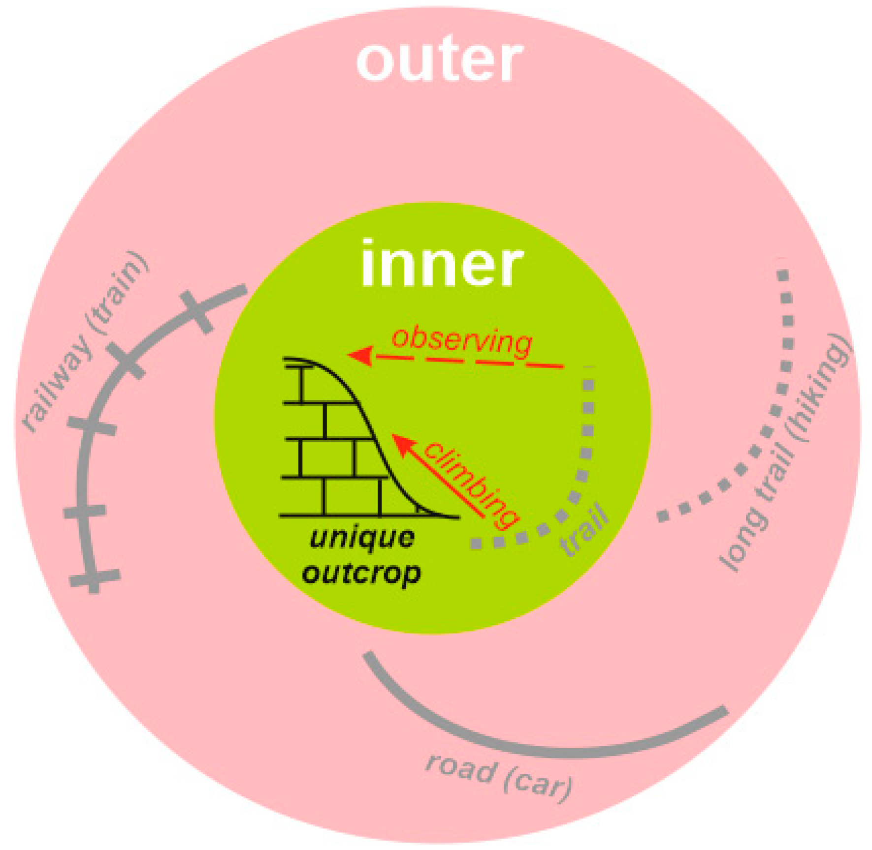
Evaluating the accessibility of geosites requires finding proper criteria to be followed for the development of a scoring system. Previous researchers (for instance, [1,4,15,16]) proposed different criteria, which need systematization and additions. However, the principal issue is establishing the difference between inner and outer accessibility (Figure 1).
Inner accessibility is linked to on-site, “touch-the-rock” opportunities. In some cases, visitors can stand in front of a given outcrop or quarry wall, inspect rocks, minerals, fossils, or tectonic structures, touch them, measure them, and even collect samples (if permitted for the purposes of research or museum or amateur collection). In some other cases, visitors need to climb the outcrop (which may be quite tall) or jump through a nearby stream to reach the geological features—i.e., some training is required. However, if this outcrop is large and well visible (and not masked by vegetation or slope debris) from the nearby plots, this partly solves the problem, because direct contact with rocks is not necessary in this case to comprehend the site’s unique features. All these issues matter even more when large geosites occupying several square kilometers are considered. The idea of inner accessibility clearly corresponds partly with what was considered by Warowna et al. [16].
Outer accessibility is linked to how to arrive at a given geosite. Undoubtedly, public transport (not necessarily buses, but also trains and other facilities), cars, and hiking can be used for this. Much depends on the physical quality of routes and their longevity [1,4]. Whether roads are paved or not may or may not matter. In some cases, paved roads may be less accessible than unpaved ones due to road slipperiness on steep slopes. Thus, it appears to be more reasonable to distinguish high-quality roads appropriate for all cars, buses, and bikes and not depending on seasonal/weather conditions from poor-quality roads to be used only by cars with special technical characteristics or mountain bikes and depending on seasonal/weather conditions. A more challenging question is how to address the longevity of routes because it depends on the physical abilities and perceptions of visitors (cf. [1]). Considering exact distances (for instance, 500 m or 1 km) seems to be less reasonable because these mean different things to different people and in different contexts (500 m in Austria, Russia, and Sudan have different meanings). It is important to understand what distance means to hikers (not cars or buses) and when trails are in a good condition. In such cases, 1 h of hiking seems to be a proper threshold to argue for better and worse accessibility. If trails are in a bad condition, depend on weather, or if they are ephemeral or do not exist at all, accessibility is restricted to a significant degree irrespective of visitors’ abilities and perceptions. Bad roads and trails may be partly recompensed by panoramic viewpoints offering observation of unique features from good roads and other well-accessible places. The importance of such viewpoints is argued in the works by Migoń and Pijet-Migoń [17], Migoń and Różycka [18], and Mikhailenko and Ruban [19]. Finally, it is also possible that some geosites are situated in remote and wild places, and reaching them requires full-scale, well-prepared expeditions.
Inner accessibility and outer accessibility refer to different spaces. The former refers to the space occupied by a given geosite itself. The latter refers to the space around a given geosite or, better put, between this geosite and the nearby transport infrastructure. The boundary between these spaces (and, thus, the limit between inner and outer accessibility) corresponds exactly to the official boundary of a given geosite, as each geosite needs to be well delineated in its space.
One may argue that the carrying capacity of geosites [1,20] can be considered among the criteria of accessibility. Although each geosite occupies limited space for a limited number of persons, carrying capacity is a fundamentally different property linked to the physical parameters of a geosite and the efficacy of crowding management [21]. Accessibility is the very possibility to reach unique features, and it does not depend on the number of visitors. Therefore, carrying capacity should not be mixed with accessibility. For the same reason, the latter is not determined by the presence/absence of parking places for cars and excursion buses. In contrast, several other factors limiting accessibility should be considered. These include entrance fees (for instance, if a geosite is located in a biosphere reserve or natural park) and required permissions (for instance, if a geosite is a private property or under special state protection). Some previously proposed approaches (e.g., [1]) address these factors, but it appears to be important to judge them together with accessibility, as they restrict the possibility to reach unique features. For instance, when visitors are not ready to pay high entrance fees or cannot obtain permission due to over-bureaucratic procedures, they cannot access geosites.
2.2. Scoring System
The abovementioned criteria (parameters, conditions, and factors) can be employed for the development of a scoring system. This is based on three propositions. First, inner and outer accessibility matter equally. Second, the possibility of distant observation recompenses restricted accessibility, but to a moderate degree in the case of inner accessibility and to a low degree in the case of outer accessibility. This is so because many details are invisible from a significant distance, and panoramic viewing of geosites is not equal to rock touching and sampling. Third, entrance fees and required permissions decrease accessibility, although only slightly because these barriers are generally possible to overcome with varied difficulty. The proposed scoring system is explained in Table 1. For each geosite, the scores of inner and outer accessibility are summarized, and a few points are subtracted from the score in cases of entrance fees or required permission. The resulting total scores correspond to any of three grades, which are delineated to take into account the best and worst conditions.
Several notes on the proposed scoring system should be added. First, Brilha [1] related accessibility to the educational and tourism functions of geosites. Although this idea does not deserve criticism, it must be noted that scientists, including experts in geoheritage, are also among geosite visitors, and thus, accessibility seems to be a universal property. Second, poor-quality roads may not be a serious challenge to some local drivers. However, this does not increase accessibility because the availability of such drivers is another restriction. Third, the possibility to use horses or camels for bad-quality roads and ephemeral trails does not matter because not everyone is ready for such transportation today. Fourth, when geosites available through water or air transport are considered, their accessibility can be scored intuitively, but through a similar set of criteria. It should be understood, however, that options such as hiking cannot recompense the absence of water or air transport and safe water/air routes in these cases. Fifth, special interpretative panels [22,23] can be installed at points of distant observation. Although they facilitate comprehension of the observed unique features, such panels do not increase the sites’ physical visibility and, thus, do not contribute to better accessibility.
The proposed scoring system is clearly not only simple, but also not dependent on context and situations. However, it at least avoids the issues of different meanings of distances, different training of visitors, and different levels of infrastructure development between countries and regions. Nevertheless, the possibility cannot be excluded that before further practical application can be achieved, the proposed system will need to be made even more universal.
3. Method Application
3.1. Geosite Accessibility in Mountainous Adygeya
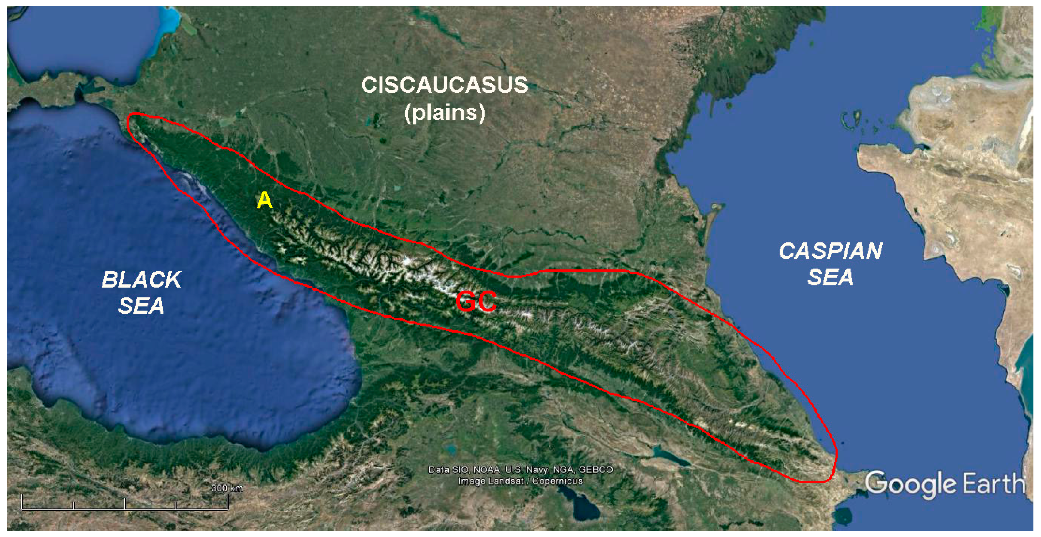
Mountainous Adygeya is a territory in southwestern Russia. It corresponds to the “core” of the Western Caucasus, which is a segment of the lengthy chain of the Greater Caucasus mountains stretching from the Black and Azov seas to the Caspian Sea (Figure 2). This territory is dominated by mountains (often cuesta-type ranges) with elevations from 500 to 700 m to >2500 m and valleys of the Belaya River and its tributaries, and this is one of the most important tourist destinations of the Russian South [24]. Geologically, it corresponds to the northwestern part of the Cenozoic fold–thrust belt [25,26,27,28,29] where Precambrian, Paleozoic, and especially Mesozoic rocks (chiefly sedimentary, but also igneous and metamorphic) with notable fossil assemblages, paleogeographical features (for instance, paleoreefs), and mineral occurrences are widely exposed. Due to the outstanding richness (abundance and diversity) of its unique geological and geomorphological features, Mountainous Adygeya is recognized as a geodiversity hotspot [5]. Therefore, this territory seems to be very suitable for testing the proposed method of semiquantitative evaluation of geosite accessibility.
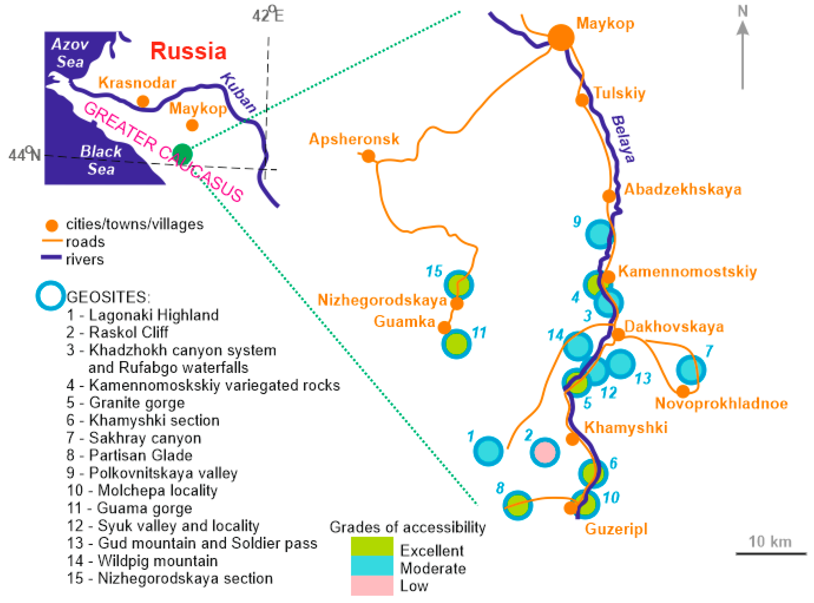
A total of 15 geosites are established in Mountainous Adygeya (the information from [5] has been updated). These tend to concentrate in the Belaya River valley and on the northwestern periphery of the Lagonaki Highland (Figure 3). The geosites differ by the unique features they represent, as well as their heritage value (Table 2). A third of them, including the largest geosite of the Lagonaki Highland, demonstrate outstanding value, and these are of either global or national importance.
These 15 geosites have been inspected in the field (some of them have been visited almost each year for more than two decades), and thus, enough information about their accessibility has been accumulated. The presence of entrance fees or required permissions has been checked regularly. This information can be employed to evaluate accessibility with the proposed method. The results are summarized in Table 2 and briefly explained below (see also Figure 3 and Figure 4).
The accessibility of geosites differs significantly in Mountainous Adygeya. Seven of them (47%) demonstrate excellent accessibility, as visitors have unlimited opportunities to reach the unique features on-site, and outer accessibility is provided by high-quality roads and sometimes by public transport. A typical example is the Guama gorge (item 10 in Table 2 and Figure 3), where visitors walk by a well-developed trail along the Kurdzhips River with excellent possibility to see landform peculiarities and to inspect lengthy outcrops of the Tithonian reefal limestones. Moreover, there is a tourist railway functioning along the same trail (Figure 4e). This geosite is connected by a modern paved road to nearby settlements and tourist centers. Seven (47%) geosites have moderate accessibility, which is diminished by various factors. For instance, the Sakhray canyon (item 7 in Table 2 and Figure 3) is a spectacular object with waterfalls, deformed Triassic rocks, and variegated Late Triassic reefal limestones. However, visitors should be well trained to walk inside this narrow river valley with a fast and rather deep stream and slippery rock exposures. These difficulties are partly recompensed by the availability of a few points for distant observation, although the visibility of waterfalls is limited there. Moreover, this geosite is located in a remote and wild place where a narrow forest road is of poor quality and requires significant experience of drivers (and which is also inappropriate for many types of cars). Finally, only one geosite, the Raskol Cliff (item 2 in Table 2 and Figure 3), is characterized by low accessibility. Visitors need to be well trained for walking near the outcrops of the Late Permian reef, but arriving there is even more challenging because this geosite, which is essentially a relatively tall mountain with steep slopes, is situated in a wild place with dense forests and far from roads and trails. Fortunately, it is well observable from the village of Khamyshki, although its identification as a paleoreef requires professional interpretation (of course, rocks with numerous fossils are completely invisible from a distance of ~3 km).
Two additional notes are necessary. First, none of the geosites of Mountainous Adygeya with a global value boasts excellent accessibility (Figure 3). However, the Lagonaki Highland has, at least, high outer accessibility, and its inner accessibility is also high in some parts (see below). Second, the accessibility of four geosites (27%) is reduced by the presence of entrance fees, which are relatively high in some cases, or the required permissions, which there is no guarantee that potential visitors will be able to obtain.
3.2. Spatial Heterogeneity of Geosite Accessibility
The undertaken evaluation of geosite accessibility in Mountainous Adygeya reveals two particularly interesting patterns, which are both linked to spatial heterogeneity. Three large geosites, namely, the Lagonaki Highlands, the Khadzhokh canyon system and Rufabgo waterfalls, and the Gud Mountain and Soldier Pass (items 1, 3, and 13 in Table 2 and Figure 3), have different inner (and in one case also outer) accessibility in different parts. For instance, the flat surface of the Stonesea Range near the entrance to the Lagonaki Highland can be visited without any serious restrictions (except for severe weather conditions); walking to the area at the toe of the Abadzesh and Oshten mountains and near the Instructor’s Slit requires training (Figure 4b), but this area is visible from easily accessible places; and the other parts of this geosite are both difficult to reach (Figure 5) and often invisible from well-accessible viewpoints. In another case, the Soldier Pass is easily accessible via a high-quality road and public transport. In contrast, the interesting geological features near the top of the Gud mountain are very difficult to access due to dense vegetation, rather steep slopes, and the absence of well-established trails. In such situations, average accessibility scores are given (Table 2), but the noted heterogeneity poses a challenge to geosite management.
The other pattern is linked to spatial heterogeneity within the entire territory of Mountainous Adygeya. Geosites with very different accessibility co-exist there (Figure 3). Objects with unlimited access are usually found along principal roads and/or within urban areas where rock outcrops and landforms are exposed to flat and open spaces without dense vegetation. However, numerous rivers and streams, steep slopes, dense vegetation, and underdevelopment of the local network of roads and trails decrease accessibility in many other cases, including several geosites, which cannot be judged as too remote. A typical example is the Wildpig mountain (item 14 in Table 2 and Figure 3). This spectacular landform with very unusual outcrops of the Aalenian–Bajocian rose crinoidal limestones at its top would attract a lot of visitors. Its slopes are not too steep, but they are covered by tall grass, and the absence of trails is a serious challenge for its inner accessibility. This geosite is surrounded by a flat surface of river terrace, but only an unpaved road, unsuitable for many types of cars, connects it to the nearby village of Dakhovskaya. This seems to be a restriction of outer accessibility. Generally, the heterogeneity of outer accessibility in the entire Mountainous Adygeya results from both its natural peculiarities and the socioeconomical state (and history) determining infrastructural development.
4. Discussion and Conclusions
The proposed method is easy to use and allows addressing various situations linked to geosite accessibility. It can be applied in the course of geoheritage assessment of particular territories. The example of the Mountainous Adygeya geodiversity hotspot proves the method’s applicability. Moreover, this method helps to find gaps to be filled in the course of geoconservation activities and geotourism development, i.e., it is important to formulate managerial implications. For instance, its tentative application to Mountainous Adygeya identifies the geosites with excellent accessibility, which can be used for the purposes of geotourism “here and now”, and the geosites where accessibility needs improvement before their active use for the purposes of geotourism. This is especially the case for the globally ranked Raskol Cliff and parts of the Lagonaki Highlands where scientists, students, and tourists need more possibilities to reach localities of outstanding importance.
Of course, all methods have limitations, which are almost unavoidable. The proposed semiquantitative approach has three such limitations. First, the factor of seasonality is not taken into account. Brilha [1] considered this, but not in connection to accessibility, whereas Warowna et al. [16] linked this factor to both accessibility and exposure. Indeed, some geosites may be (almost) inaccessible in some seasons. However, seasonality influences accessibility more or less similarly within the same territory (and even within the same country). Severe weather conditions with a lot of snow or continuous rainfall may also occur during seasons commonly judged to be favorable for visiting a given geosite. A huge amount of meteorological information (sometimes lacking) and its highly complex treatment are required in order to judge this factor. Moreover, many people prefer to visit geosites in particular seasons with conditions that do not restrict accessibility [30,31]. It should be noted that the proposed scored system depends on road/trail quality. Bad weather has a worse impact on bad-quality roads and trails, which receive lower scores regardless, and thus, the discussed parameter is taken into account indirectly. Second, this method does not consider whether accessibility can be facilitated via mobile guiding techniques, including those using GIS and GPS solutions [32,33,34,35]. However, such techniques are not widespread, and judging the quality of mobile networks requires too-specific knowledge from geoheritage experts (which also changes rapidly). This is a task for further discussions to determine whether this factor should be considered in the semiquantitative evaluation of geosite accessibility and, if yes, how. Third, the proposed method is developed separately, i.e., outside of the methodologies of general geoheritage assessment. These systems are based on different criteria and different scoring systems (for instance, [1,4,15,16]). Nonetheless, it appears that the three grades of accessibility proposed in this paper can be easily integrated into all kinds of general methodologies, and scores can be assigned to these grades depending on the needs of a given researcher.
It is of great interest to determine whether this proposed method gathers results which are different from those obtained using earlier proposed methods, including the scoring systems from the works of Brilha [1] and Warowna et al. [16]. In fact, serious differences should exist. Brilha [1] chiefly dealt with outer accessibility, and Warowna et al. [16] involved the factor of seasonality. The previous scoring systems [1,16] do not cover the situations found in Mountainous Adygeya. For instance, the quality of roads does not permit reaching some geosites using all types of cars. The distances indicated by Brilha [1] may be suitable for the European context, but they are sometimes too small for Russian space dimensions and their perceptions. Thus, the problem is not the difference in the results, but the difficulties and the questioned reasonability associated with the application of previous methods in a given study area.
To conclude, accessibility as a technical, but important property of geosites appears to be rather complex. It is determined by inner (on-site) and outer accessibility, which can be scored through a set of criteria. The proposed method is tentative and even somewhat intuitive, but it allows easily and effectively distinguishing between three grades of accessibility. This contributes to geoheritage characteristics and has evident managerial implications. This method needs further testing, discussions, and possible justifications. Particularly, it is important to realize that some geosites can be reached by boats or helicopters, as well as virtually. Therefore, our understanding of the concept accessibility will expand in the future.
Author Contributions
Conceptualization, D.A.R.; methodology, A.V.M. and D.A.R.; investigation, A.V.M. and D.A.R.; writing—original draft preparation, D.A.R. and V.A.E.; writing—review and editing, D.A.R. All authors have read and agreed to the published version of the manuscript.
Funding
This research received no external funding.
Institutional Review Board Statement
Not applicable.
Informed Consent Statement
Not applicable.
Data Availability Statement
Not applicable.
Acknowledgments
We gratefully thank the editor and both anonymous reviewers for their thorough consideration of our paper and helpful recommendations.
Conflicts of Interest
The authors declare no conflict of interest.
References
- Brilha, J. Inventory and quantitative assessment of geosites and geodiversity sites: A review. Geoheritage 2016, 8, 119–134. [Google Scholar] [CrossRef] [Green Version]
- Pereira, P.; Pereira, D.; Alves, M. The geomorphological heritage approach in protected areas: Geoconservation vs. Geotourism in Portuguese natural parks. Mem. Descr. Della Carta Geol. D’Italia 2009, 87, 135–144. [Google Scholar]
- Prosser, C.; Murphy, M.; Larwood, J. Geological Conservation: A Guide to Good Practice; English Nature: Peterborough, UK, 2006. [Google Scholar]
- Reynard, E.; Brilha, J. (Eds.) Geoheritage: Assessment, Protection, and Management; Elsevier: Amsterdam, The Netherlands, 2018. [Google Scholar]
- Ruban, D.A. Quantification of geodiversity and its loss. Proc. Geol. Assoc. 2010, 121, 326–333. [Google Scholar] [CrossRef]
- Štrba, L.; Rybar, P.; Balaz, B.; Molokac, M.; Hvizdak, L.; Krsak, B.; Lukac, M.; Muchova, L.; Tometzova, D.; Ferencikova, J. Geosite assessments: Comparison of methods and results. Curr. Issues Tour. 2015, 18, 496–510. [Google Scholar] [CrossRef]
- Zwoliński, Z.; Stachowiak, J. Geodiversity map of the Tatra National Park for geotourism. Quaest. Geogr. 2012, 31, 99–107. [Google Scholar] [CrossRef] [Green Version]
- Ferreira, A.R.R.; Lobo, H.A.S.; de Jesus Perinotto, J.A. Inventory and Quantification of Geosites in the State Tourist Park of Alto Ribeira (PETAR, São Paulo State, Brazil). Geoheritage 2019, 11, 783–792. [Google Scholar] [CrossRef]
- Armiero, V.; Lirer, L.; Petrosino, P. The Solfatara: Volcanological survey and proposal of institution of a Geosite in Campi Flegrei. Rend. Della Soc. Geol. Ital. 2007, 5, 3–30. [Google Scholar]
- Coratza, P.; Vandelli, V.; Fiorentini, L.; Paliaga, G.; Faccini, F. Bridging terrestrial and marine geoheritage: Assessing geosites in Portofino Natural Park (Italy). Water 2019, 11, 2112. [Google Scholar] [CrossRef] [Green Version]
- Migoń, P.; Pijet-Migoń, E. Overlooked Geomorphological Component of Volcanic Geoheritage—Diversity and Perspectives for Tourism Industry, Pogórze Kaczawskie Region, SW Poland. Geoheritage 2016, 8, 333–350. [Google Scholar] [CrossRef]
- Pinińska, J.; Domonik, A.; Dziedzic, A.; Łukasiak, D. The methodology of a complex engineering-geological approach to establish a geopark: Case study of the Małopolska Wisła River Gorge. Geol. Q. 2014, 59, 408–418. [Google Scholar] [CrossRef] [Green Version]
- Lima, E.A.; Machado, M.; Ponte, J. Geological heritage management: Monitoring the Azores geopark geosites. Comun. Geol. 2014, 101, 1295–1298. [Google Scholar]
- Vegas, J.; Díez-Herrero, A. An Assessment Method for Urban Geoheritage as a Model for Environmental Awareness and Geotourism (Segovia, Spain). Geoheritage 2021, 13, 27. [Google Scholar] [CrossRef]
- Kubalíkova, L.; Drápela, E.; Kirchner, K.; Bajer, A.; Balková, M.; Kuda, F. Urban geotourism and geoconservation: Is it possible to find a balance? Environ. Sci. Policy 2021, 121, 1–10. [Google Scholar] [CrossRef]
- Warowna, J.; Zgłobicki, W.; Kołodyńska-Gawrysiak, R.; Gajek, G.; Gawrysiak, L.; Telecka, M. Geotourist values of loess geoheritage within the planned Geopark Małopolska Vistula River Gap, E Poland. Quat. Int. 2016, 399, 46–57. [Google Scholar] [CrossRef]
- Migoń, P.; Pijet-Migoń, E. Viewpoint geosites—Values, conservation and management issues. Proc. Geol. Assoc. 2017, 128, 511–522. [Google Scholar] [CrossRef]
- Migoń, P.; Różycka, M. When individual geosites matter less—Challenges to communicate landscape evolution of a complex morphostructure (Orlické–Bystrzyckie mountains block, Czechia/Poland, Central Europe). Geosciences 2021, 11, 100. [Google Scholar] [CrossRef]
- Mikhailenko, A.V.; Ruban, D.A. Environment of Viewpoint Geosites: Evidence from the Western Caucasus. Land 2019, 8, 93. [Google Scholar] [CrossRef] [Green Version]
- Lima, A.; Nunes, J.C.; Brilha, J. Monitoring of the Visitors Impact at “Ponta da Ferraria e Pico das Camarinhas” Geosite (São Miguel Island, Azores UNESCO Global Geopark, Portugal). Geoheritage 2017, 9, 495–503. [Google Scholar] [CrossRef] [Green Version]
- Jin, Q.; Ruban, D.A. A conceptual framework of tourism crowding management at geological heritage sites. Nat. Nascosta 2011, 43, 1–17. [Google Scholar]
- Began, M.; Višnic, T.; Djokic, M.; Vasiljevic, D.A. Interpretation Possibilites of Geoheritage in Southeastern Serbia—Gorge and Canyon Study. Geoheritage 2017, 9, 237–249. [Google Scholar] [CrossRef]
- Bruno, B.C.; Wallace, A. Interpretive Panels for Geoheritage Sites: Guidelines for Design and Evaluation. Geoheritage 2019, 11, 1315–1323. [Google Scholar] [CrossRef]
- Ivlieva, O.V.; Shmytkova, A.V.; Sukhov, R.I.; Kushnir, K.V.; Grigorenko, T.N. Assessing the tourist and recreational potential in the South of Russia. E3S Web Conf. 2020, 208, 05013. [Google Scholar] [CrossRef]
- Adamia, S.; Zakariadze, G.; Chkhotua, T.; Sadradze, N.; Tsereteli, N.; Chabukiani, A.; Gventsadze, A. Geology of the Caucasus: A review. Turk. J. Earth Sci. 2011, 20, 489–544. [Google Scholar]
- Ismail-Zadeh, A.; Adamia, S.; Chabukiani, A.; Chelidze, T.; Cloetingh, S.; Floyd, M.; Gorshkov, A.; Gvishiani, A.; Ismail-Zadeh, T.; Kaban, M.K.; et al. Geodynamics, seismicity, and seismic hazards of the Caucasus. Earth Sci. Rev. 2020, 207, 103222. [Google Scholar] [CrossRef]
- Kaban, M.K.; Gvishiani, A.; Sidorov, R.; Oshchenko, A.; Krasnoperov, R.I. Structure and density of sedimentary basins in the southern part of the east-European platform and surrounding area. Appl. Sci. 2021, 11, 512. [Google Scholar] [CrossRef]
- Trifonov, V.G.; Sokolov, S.Y.; Sokolov, S.A.; Hessami, K. Mesozoic–Cenozoic Structure of the Black Sea–Caucasus–Caspian Region and Its Relationships with the Upper Mantle Structure. Geotectonics 2020, 54, 331–355. [Google Scholar] [CrossRef]
- Van Hinsbergen, D.J.J.; Torsvik, T.H.; Schmid, S.M.; Matenco, L.C.; Maffione, M.; Vissers, R.L.M.; Gürer, D.; Spakman, W. Orogenic architecture of the Mediterranean region and kinematic reconstruction of its tectonic evolution since the Triassic. Gondwana Res. 2020, 81, 79–229. [Google Scholar] [CrossRef]
- Drápela, E.; Bohác, A.; Böhm, H.; Zágoršek, K. Motivation and preferences of visitors in the Bohemian Paradise UNESCO global geopark. Geosciences 2021, 11, 116. [Google Scholar] [CrossRef]
- Baláž, B.; Štrba, L.; Lukác, M.; Drevko, S. Geopark development in the Slovak republic–alternative possibilities. Int. Multidiscip. Sci. GeoConf. Surv. Geol. Min. Ecol. Manag. 2014, 2, 313–320. [Google Scholar]
- Cayla, N. An Overview of New Technologies Applied to the Management of Geoheritage. Geoheritage 2014, 6, 91–102. [Google Scholar] [CrossRef]
- Chu, T.-H.; Lin, M.-L.; Chang, C.-H. mGuiding (Mobile Guiding)-Using a Mobile GIS app for Guiding. Scand. J. Hosp. Tour. 2012, 12, 269–283. [Google Scholar] [CrossRef]
- Filocamo, F.; Di Paola, G.; Mastrobuono, L.; Rosskopf, C.M. MoGeo, a mobile application to promote geotourism in Molise region (Southern Italy). Resources 2020, 9, 31. [Google Scholar] [CrossRef] [Green Version]
- Pica, A.; Reynard, E.; Grangier, L.; Kaiser, C.; Ghiraldi, L.; Perotti, L.; Del Monte, M. GeoGuides, Urban Geotourism Offer Powered by Mobile Application Technology. Geoheritage 2018, 10, 311–326. [Google Scholar] [CrossRef]
Figure 1.
Conceptual representation of the idea of inner and outer accessibility of geosites.

Figure 2.
Location of the Greater Caucasus mountains (GC) and the study area (A). Source image: Google Earth Engine.
Figure 2.
Location of the Greater Caucasus mountains (GC) and the study area (A). Source image: Google Earth Engine.

Figure 3.
Geosites of Mountainous Adygeya and their different accessibility.

Figure 4.
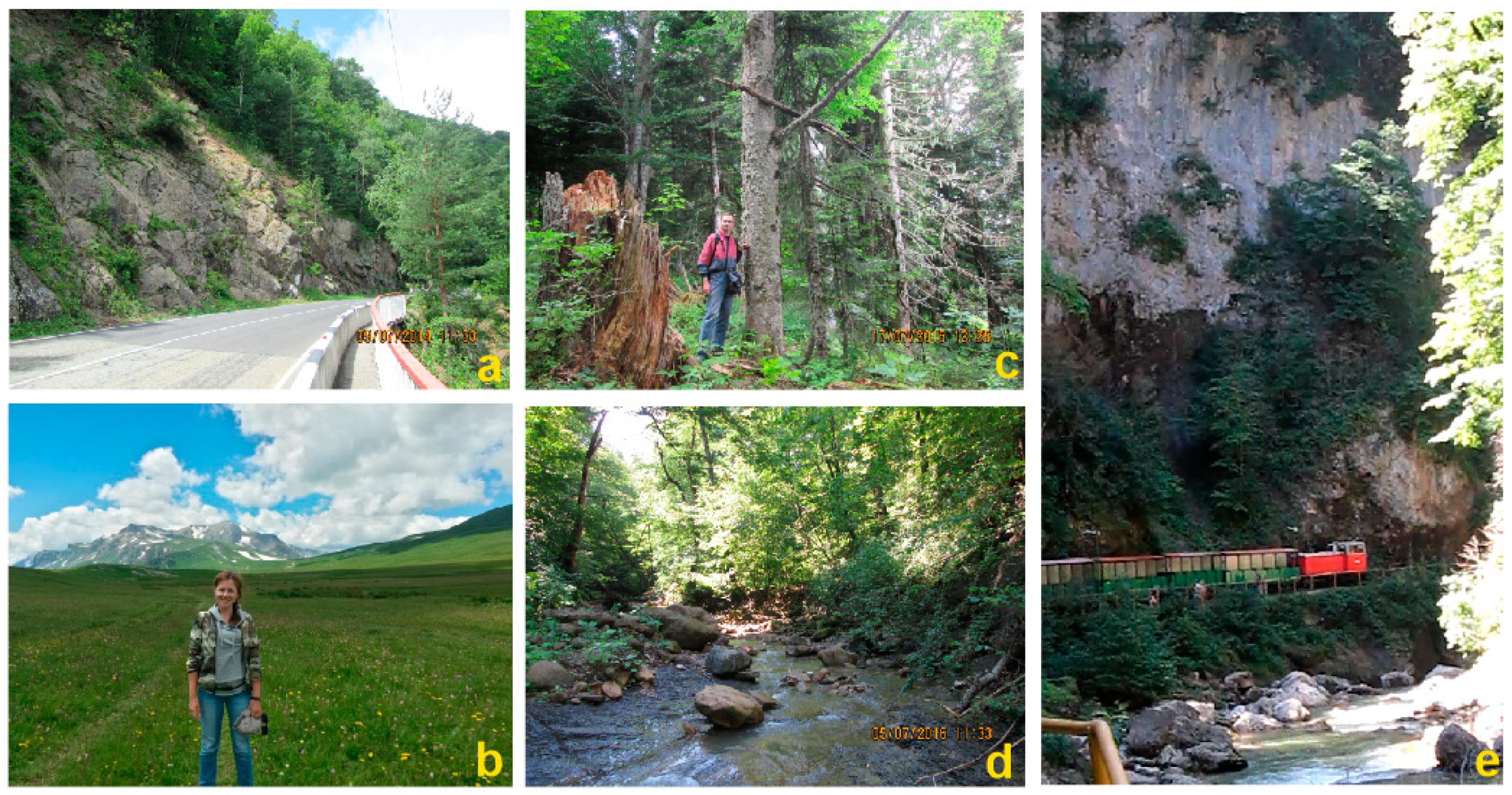
Selected examples of geosite accessibility in Mountainous Adygeya: (a) granite outcrops along the paved road with regular public transport (item 5 in Table 2 and Figure 3); (b) training is required to enjoy the internal parts of the Late Jurassic carbonate platform and paleoreefs (item 1 in Table 2 and Figure 3); (c) the dense forest makes it extremely challenging to reach the southwestern toes of the cuesta-type range (item 1 in Table 2 and Figure 3); (d) slippery rocks, boulders and blocks, and woody debris restrict walking along the lengthy outcrops of the Toarcian–Aalenian dark shales (item 12 in Table 2 and Figure 3); (e) a touristic train facilitates visiting the deep gorge and viewing the spectacular outcrops of the Tithonian carbonates (item 11 in Table 2 and Figure 3). A.V.M. present for scale in (b), and D.A.R. present for scale in (c).
Figure 4.
Selected examples of geosite accessibility in Mountainous Adygeya: (a) granite outcrops along the paved road with regular public transport (item 5 in Table 2 and Figure 3); (b) training is required to enjoy the internal parts of the Late Jurassic carbonate platform and paleoreefs (item 1 in Table 2 and Figure 3); (c) the dense forest makes it extremely challenging to reach the southwestern toes of the cuesta-type range (item 1 in Table 2 and Figure 3); (d) slippery rocks, boulders and blocks, and woody debris restrict walking along the lengthy outcrops of the Toarcian–Aalenian dark shales (item 12 in Table 2 and Figure 3); (e) a touristic train facilitates visiting the deep gorge and viewing the spectacular outcrops of the Tithonian carbonates (item 11 in Table 2 and Figure 3). A.V.M. present for scale in (b), and D.A.R. present for scale in (c).

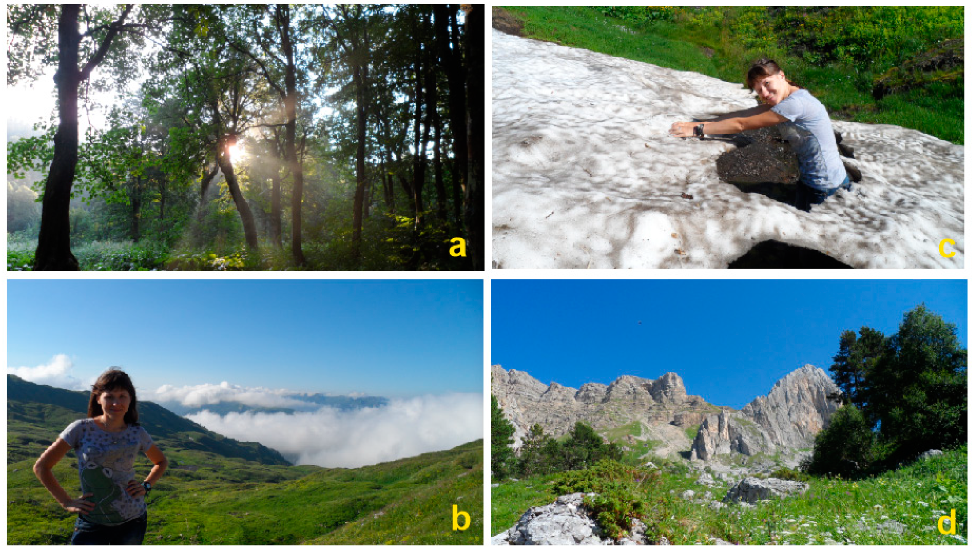
Figure 5.
A trail along the southern edge of the Lagonaki Highland (item 1 in Table 2 and Figure 3) leads through a dense forest (a), high pass (b), snowfields (c), and block accumulations (d). Walking many kilometers along this trail requires training, as well as preparedness to face truly wild nature in a remote part of high mountains. A.V.M. present for scale in (b,c).


Table 1.
A scoring system proposed to assess geosite accessibility.
| Inner Accessibility | Outer Accessibility | |||
|---|---|---|---|---|
| State | Scores | State | Scores | |
| Unlimited Access | 10 | Public Transport (Bus, Train, etc.) Available | 10 | |
| High-Quality Road (Unlimited Access by Cars and Excursion Buses) | 7 | |||
| Training Required for Access, Distant Observation Possible | 5 | Poor-Quality Road (Restricted Access by Selected Cars) | 5 | |
| Well-Established Trail (Unlimited Access by Hiking, <1 h) | 5 | |||
| Well-Established Trail (Unlimited Access by Hiking, >1 h) | 3 | |||
| Training Required for Access, Distant Observation Impossible | 1 | Ephemeral Trail (Access by Trained Hikers) | 1 | |
| Observation from Remote Viewpoint | 1 | |||
| Location in Remote and Wild Place | 0 | |||
| Entrance fee/required permission | −3 | |||
| TOTAL | from 0 to 20 | |||
| Grades of accessibility | ||||
| Excellent | >15 | |||
| Moderate | from 7 to 15 | |||
| Low | <7 | |||
Table 2.
Results of the accessibility assessment of the Mountainous Adygeya geosites.
| Geosite (Figure 2) | Unique Features | Geosite Value | Accessibility | |||
|---|---|---|---|---|---|---|
| Inner | Outer | Fee | Total | |||
| 1 | Late Jurassic carbonate platform, reefs, and fossils, modern karst, panoramic views | Global | 1–10 (av. 5) | 7 | −3 | 9 |
| 2 | Late Permian reefs | Global | 5 | 0 | 0 | 5 |
| 3 | canyons and klamm, Triassic sequences, chevron folds, waterfalls, megaclasts | National | 1–10 (av. 5) | 10 | −3 | 12 |
| 4 | Late Jurassic sabkha outcrops | National | 10 | 10 | 0 | 20 |
| 5 | Precambrian metamorphic rocks, Early Paleozoic serpentinites, Late Paleozoic granitoids | National | 10 | 10 | 0 | 20 |
| 6 | Permian molasse, Jurassic outcrops | National | 10 | 10 | 0 | 20 |
| 7 | Triassic sequences, tectonic dislocations, waterfalls | Regional | 5 | 5 | 0 | 10 |
| 8 | Early–Middle Jurassic dark shales, tectonic dislocations, panoramic views | Regional | 10 | 7 | 0 | 17 |
| 9 | Mid-Cretaceous green sandstones, gigantic ammonites | Regional | 5 | 5 | −3 | 7 |
| 10 | Early Jurassic ichnofossils, geoarchaeological site | Regional | 10 | 10 | −3 | 17 |
| 11 | natural and artificial landforms, Late Jurassic limestones | Regional | 10 | 10 | 0 | 20 |
| 12 | Early–Middle Jurassic dark shales, tectonic dislocations, fossil invertebrates | Local | 5 | 10 | 0 | 15 |
| 13 | isolated mountain, Middle Jurassic sequences, panoramic views | Local | 1–10 (av. 5) | 1–10 (av. 5) | 0 | 10 |
| 14 | isolated mountain, Middle Jurassic crinoid limestones, gigantic bivalves | Local | 5 | 5 | 0 | 10 |
| 15 | Fuabginskaya Formation reference section | Local | 10 | 10 | 0 | 20 |
Note: the scores for inner and outer accessibility are summed, the scores for the presence of entrance fees/required permissions are subtracted, and the rest is the total value (see methodological explanations above for more details).
Publisher’s Note: MDPI stays neutral with regard to jurisdictional claims in published maps and institutional affiliations. |
© 2021 by the authors. Licensee MDPI, Basel, Switzerland. This article is an open access article distributed under the terms and conditions of the Creative Commons Attribution (CC BY) license (https://creativecommons.org/licenses/by/4.0/).
Share and Cite
MDPI and ACS Style
Mikhailenko, A.V.; Ruban, D.A.; Ermolaev, V.A. Accessibility of Geoheritage Sites—A Methodological Proposal. Heritage 2021, 4, 1080-1091. https://0-doi-org.brum.beds.ac.uk/10.3390/heritage4030060
AMA Style
Mikhailenko AV, Ruban DA, Ermolaev VA. Accessibility of Geoheritage Sites—A Methodological Proposal. Heritage. 2021; 4(3):1080-1091. https://0-doi-org.brum.beds.ac.uk/10.3390/heritage4030060
Chicago/Turabian StyleMikhailenko, Anna V., Dmitry A. Ruban, and Vladimir A. Ermolaev. 2021. "Accessibility of Geoheritage Sites—A Methodological Proposal" Heritage 4, no. 3: 1080-1091. https://0-doi-org.brum.beds.ac.uk/10.3390/heritage4030060