
Underground Built Heritage (UBH) as Valuable Resource in China, Japan and Italy


1
Institute for Studies on the Mediterranean (ISMed), National Research Council of Italy (CNR), 80134 Naples, Italy
2
Institute of Heritage Science (ISPC), National Research Council of Italy (CNR), 20125 Milan, Italy
*
Author to whom correspondence should be addressed.
Heritage 2021, 4(4), 3208-3237; https://0-doi-org.brum.beds.ac.uk/10.3390/heritage4040180
Submission received: 24 August 2021
/
Revised: 28 September 2021
/
Accepted: 30 September 2021
/
Published: 11 October 2021
(This article belongs to the Special Issue YOCOCU2020 Hands on Heritage: Experiencing, Conservation, Mastering Management)
Abstract
:Recent research about the theoretical approach to elements of cultural heritage that can be included in the newly born class Underground Built Heritage (UBH), has provided several instruments for the functional classification and the static and dynamic analysis of all artefacts coherent with the given definition, while introducing several criteria for their reuse and the evaluation of connected enhancement processes as well. These guidelines can be adopted to analyze single artefacts, groups of homogenous or heterogeneous elements, and also selected territorial assets or national systems, even at a comparative level. With reference to this potential, research results from the application of this new methodological approach to the outputs of three ongoing projects by the National Research Council of Italy, all focusing on UBH, in three countries: China, Japan and Italy, are presented. With reference to the above-mentioned geographical contests, the research introduces a comparative study focusing on selected examples of artefacts that have been historically built underground to manage three functions: living space, religion and economy. This study, carried out based on data collected during onsite visits by the authors, consists in three steps: selection and analysis of case studies, definition of level of reuses on the basis of a given scale, and analysis of the different tools adopted for their conservation and enhancement. In the conclusions, possible future implementations of reuses of the analyzed elements are pointed out.
1. Introduction
The recent publication of a theoretical approach dedicated to the definition and to the study of elements of cultural heritage that can be included in a newly born class which has been named Underground Built Heritage (UBH), gives the opportunity for both static and dynamic analysis of single artefacts, selected groups of them and, also, different territorial assets where those artefacts can be found [1]. The method consists of three different stages: the first is the selection of the sites through the verification of their compatibility with the identified guide lines, which foresee that only those artefacts built below the zero level in application of the so called “negative building culture” can be included, the second is the functional classification on the basis of eight functions pointed out and of a given chart, and the third is the study of their historical or contemporary reuses based on a four-level scale.
This new methodological approach has finally provided the necessary tools to overcome all the difficulties, both at the terminological and procedural level, that up to now, scholars, operators and institutions have had to face when approaching historical artefacts caved underground. This approach, which has been elaborated based on the critical analysis and updating of previous attempts in this direction [1], has been an opportunity to reorganize the outputs of three still ongoing projects from the National Research Council of Italy (CNR), all regarding the sharing of good practices in conservation and enhancement of natural and cultural sites that can now profitably be included in the UBH class in three very heterogeneous countries: China, Japan and Italy.
The first project whose outputs have been adopted as sources for this paper is the bilateral project between CNR and the Chinese Academy of Cultural Heritage (CACH) entitled “Identification and Interpretation of Cultural Route: the Example of Maritime Silk Road” (2019–2021) [2]. The second one is the bilateral project between CNR and the Japan Society for the Promotion of Science (JSPS) entitled “Damage assessment and conservation of underground spaces as valuable resource for human activities use in Italy and Japan” (2018–2019/2020–2021) [3]. The third one is the Interdepartmental agreement “Southern Anthropic Subsoil” signed in 2015 by five institutes from the CNR: the Institute of Studies on the Mediterranean Societies (ISSM) (now Institute for Studies on the Mediterranean—ISMed), the Institute of Methodologies for Environmental Analysis (IMAA), the Research Institute for Geo-Hydrological Protection (IRPI), the Institute for Archaeological and Monumental Heritage (IBAM) and the Institute for the Conservation and Valorization of Cultural Heritage (ICVBC) (the last two now form part of the Institute of Heritage Science-ISPC) [4].
In particular, the first project is aimed at identifying methods and tools for interpreting, communicating and enhancing serial heritage, analyzing the effect of current practices, and proposing better and more flexible approaches to the interpretative schemes. By comparing Italian and Chinese cases, the study is attempting to create a set of guidelines for enhancing coastal-related heritage, including both popular tourism sites and less promoted ones [5,6].
The second is based upon the significant communicative role played by the underground environment in Italy and Japan, which were considered to be exemplary case studies to compare the Eastern and Western approaches to monitoring, in theoretical studies and in enhancement processes on the basis of the analysis of selected case studies within the class of UBH [7].
The third project proposes a multidisciplinary approach to the study of several rock-cut elements built on the Murge Plateau, in Southern Italy, and the introduction of a dedicated cultural route as a solution for the optimization of the dualistic touristic development of the area, an issue emphasized by the impact of Matera 2019 Capital of European Culture on the touristic fluxes in the area, which is perceived as a top priority by local administrations [8].
The general evidence from those projects is that yearly new underground assets are renovated, reused and promoted, most of them consisting of archaeological areas and monumental sites subjected to enhancement interventions that return them to society and make them a driving force for economic and social development, an aspect which strongly emerged from the first outputs of the international network established within the COSTACTION 18110 Underground4value [9], a European project which encompasses more than thirty countries, each of them valuable case studies within the UBH class, and where we, the authors, were also involved [10].
Nonetheless, the diffusion of UBH elements in all the territorial assets examined, corresponding to a wide variety of underground cultural assets—vernacular settlements, religious sites, productive spaces, etc.,—were largely unexplored, even if they were cultural resources, full of historical and cultural uniqueness, or sources of identity for local communities. Potentially, if adequately reused or enhanced, all of them could represent the basis for culture-led development strategies, aiming at reinforcing local culture and the community’s sense of pride, and from a touristic point of view could also determine the competitive edge over global travel destinations.
This culture-led development strategy, following the most up-to-date concepts of sustainable tourism [11], could be decisive for countries such as China, Japan and Italy, countries characterized by a widespread heritage including UBH, and could form the basis of both future cultural and economic growth if properly integrated and enhanced on a large territorial scale.
In this perspective, our research aimed at identifying and analyzing differences among the three national systems in terms of enhancement in this specific sector.
Although in each country conservation and protection practices can correspond to shared standards, particularly regarding UNESCO properties, the cultural and ideological bases, as well as the traditions of use and intangible values associated with heritage, can be very distant, with direct and sometimes conspicuous impacts on the interpretation and communication of the heritage itself, and consequently, on the actions of enhancement and promotion. Furthermore, site-to-site differences are all the more accentuated if one considers that many cultural sites are the product of a stratification of functions and values. In this perspective, the interpretation and communication of tangible and intangible values becomes crucial in order to strengthen the sense of place in local communities, as well as to promote and enhance those sites through sustainable development in various sectors of local economies. Sometimes, UBH elements can be profitably involved in activities related to cultural tourism, that very often represent one of the pillars of the economy of the three countries considered, but other sectors may be involved as well. We refer to the conservation or the seasoning of local typical food, to handicraft production, and to the safe conservation of selected merchandise at controlled temperatures.
Furthermore, a second aim was to evaluate how the adoption of the new theoretical approach to the elements included in the newly born class of UBH can contribute to future planning, and to shared actions to improve the efficacy of enhancement processes dedicated to this class of artefacts. In this sense, an integrated enhancement of UBH in a territorial and/or an extraterritorial system could be the basis of a sustainable approach for sharing costs and benefits, obtaining greater advantages. A strategy aimed at creating thematic paths by networking many underground sites [4,8] would go in such a direction. In addition, cultural itineraries of more famous and lesser-known sites, or integrating cultural assets, above and below the ground, could be an alternative solution to avoid anthropic pressure and create local sustainable development [12,13].
2. Materials and Methods
The paper represents a preliminary overview of the very first experimentation of the new theoretical approach to UBH case studies from China, Japan and Italy within the context of three ongoing projects. The research is based on the analysis of documentation and information collected during the onsite visits during the corresponding onsite experimental phases of the projects. The methodology adopted in this paper was organized into three different steps, according to the theoretical approach adopted.
The first was dedicated to the selection of homogenous case studies representing China, Japan and Italy, while adopting a functional classification which points out eight UBH functions—Sanitary, Water, Living Spaces, Religion, Defense, Economy, Food and Transport—each connected to the underground management of correspondent environmental conflicts, social interactions or both [1]. For the comparative analysis among the Chinese, the Japanese and the Italian UBH systems, case studies have been selected within the classes of Living Space, Religion and Economy, having been the functions that provided the most interesting case studies analyzed in the above-mentioned projects (Figure 1).
The second phase was the study of the level of reuses adopted in each country according to the reuses scale recently introduced: reinventing (dedicated to vulnerable and unique elements whose reuse must be limited to museum uses), reintroducing (dedicated to cases where the original functions can be reintroduced in accordance to current regulations), reinterpreting (when new functions can be introduced in the enhancement process but the communication of historical uses must be preserved as well) and rebuilding (when new artefacts are built by adopting historical skills) [14]. The third phase was dedicated to the analysis at a comparative level of different tools (geoparks, national parks, inscription in the UNESCO list, etc.) employed for conservation and enhancement of the categories of UBH functions, while also aiming to evaluate elements, both tangible and intangible, based on interpretation and communication. In this perspective, on the base of the selection of indicators related to the “underground heritage” consideration in China, Italy and Japan, a state-of-the-art analysis was carried out.
The presence or absence of this element in the descriptions of the properties inscribed in the UNESCO list [15] for each of the countries under consideration was adopted as a significant element for this evaluation.
In Table 1, the analysis summarized: all the properties inscribed for China, Japan and Italy have been considered but only those containing elements that can be included in the UBH class have been integrated into the table, even if the description did not mention the presence of those elements at all; in the fourth column this circumstance is evidenced.
The analysis showed three very different scenarios. While in China, out of a total of 56 sites inscribed, 28 of them (14 cultural and 4 mixed), representing 50% of the total, include the “underground factor” in the correspondent description. In Japan and in Italy the situation is quite different. In Japan, for example, out of a total of 25 sites inscribed, in 4 cultural sites, representing 16% of the total, the “underground factor” has been made explicit in the description. Meanwhile in Italy, out of a of 58 sites inscribed, only 13 cultural sites, representing 22% of the total, referred to elements of UBH in the correspondent descriptions.
At a first look it may seem that the “underground factor” is not as significant in Italy and in Japan as it is in China, but a deeper analysis showed a quite different situation.
In fact, based on the analysis of more detailed descriptions published on the websites of the properties and of selected onsite visits within the above-mentioned projects, it has emerged that the descriptions of properties in the list are not exhaustive with reference to this aspect. While in Japan, for example, the site “Hidden Christian Sites in the Nagasaki Region” includes a significant UBH element completely ignored in the description, in Italy, an additional 8 properties include underground elements. After this update, the total number of Japanese properties that can be included in the study is 6, covering 24% of the total, while in Italy the total is 21, covering 36% of the total of the inscribed properties.
On the basis of this preliminary overview, the following question arises: why in China is the “underground factor” considered so important that it is underlined in all the descriptions where elements of UBH can be found, while in Japan and in Italy this factor is so underestimated?
The final goal of the study was to verify whether this is the effect of the different weight that these elements have on local identity heritage, or rather, if the current situation is attributable to different enhancement tools dedicated to these specific artefacts.
3. Underground as a Living Space in China, Japan and Italy
Underground settlements are the result of successful and sustainable balancing attempts between maximization of environmental opportunities and minimization of natural conflicts and social interaction linkages in karst habitats between latitude 32° and 40° North; on the basis of their character, they are perfect examples of the function “Living Space” of UBH [1]. Since in China, Japan and Italy there are geological formations such as plateaus located in that range, it would be reasonable to expect that, confirming the theoretical assumption, in all three countries some types of artefacts attributable to this typology can be found. In China and in Italy, on the Loess and on the Murge plateaus, confirming what has been established at a theoretical level, caved settlements are the most characteristic elements of the local historical rural scenario. However, on the Shimōsa Plateau, equally located at 35° of latitude, there is no evidence of such formations; why? The fact is, that the Japanese Shimōsa Plateau, in spite of its name, ranges between 10 m and 150 m above sea level and can correctly classified, from the geographic point of view, as a lowland, a character that is not compatible with the given definition. On the basis of this element, the absence of caved settlements in Japan appears to be the first confirmation of the importance of carrying out comparative studies in this field, in order to evaluate the validity of the theoretical hypothesis of this research.
3.1. China
The archaeological evidence of cave life in China dates back thousands of years. Since the Beijing man (about 770,000 years ago) who belonged to Homo erectus [16,17,18], thousands of human and animal fossils, tools, handcrafted items and examples of rock art from different periods were found in cavities, differing from site to site [19]. This long-term dynamic was mainly determined by the characteristics of the soil, particularly in the karst-fluvial origin areas, where the presence of easily accessible natural cavities, or easily excavated soils, natural defenses and the availability of food and natural resources nearby, provided good conditions for life. Even in further phases, despite technological evolution and the transition from nomadic to sedentary culture, the “troglodytic lifestyle” has not changed much, remaining at the basis of the urban experience. Furthermore, in land areas, especially the Yellow River and the middle and lower reaches of the Yangtze River, where there are mostly plains, gullies, river and lakes, historically, underground spaces were used in order to fortify villages, store water and food or for burial functions. This is the case of the Banpo village [20], whose remains were found in the second terrace on the east bank of the Yellow River Valley (around 6000 years ago), in the eastern suburb of Xi’an city (Shaanxi province). Here, all of the mentioned uses of underground space were expressed: it was a ditch-enclosed settlement surrounded by a moat (about 50.000 m2), organized in a dwelling area (ca 30.000 m2) hosting houses, either semi-terrain or above ground—according to archaeologists, they were mostly crypt-type in the early stage and ground-based in the late stage, which probably reflects the development from semi-cave development to ground construction and several storage pits. The remaining enclosed space, in the east side of the village, was occupied by a pottery making area, provided by underground kilns, and a burial ground in the north consisted of different typologies of underground graves. Part of the archaeological site is now accessible to the public thanks to the creation of a museum, which was visited by the Italian team several times from 2013 onwards.
As a result of this “troglodytic lifestyle”, even today, settlements continue to be built in negative, inspired by ancient typologies, as is the case of yaodongs, whose origins are widely considered to date back to the Chinese bronze age. These are vernacular caved dwellings, characterizing rural villages in the provinces—such as Shaanxi and Shanxi, parts of Gansu, Ningxia, and Inner Mongolia—situated in the Loess Plateau. This area covers almost 640,000 km2 of North-Central China, with slopes, ridges and valleys, characterized by very fine and loamy terrain that is highly fertile and easy to dig [21]. Depending on the position on the Plateau, and consequently, on the subsoil geo-morphology and the geoclimatic conditions, yaodongs can be excavated vertically or horizontally according to a variety of plans (Figure 2b), sections and details, representing the very expression of the technical skills and traditional culture of the Loessian region [22,23].
Typically, multiple dwellings are built adjacent to or on top of one another and are connected together to form a multitiered village, often for a single clan or an extended family (Figure 3a). Terrain and semi-terrain elements are combined with a structure built above ground, in order to form an integrated complex connected by a path [24].
Typically, a yaodong has a long, vaulted room with a semicircular entrance enclosed by walls, in different materials from case to case, and a wooden arch-shaped door or a quilt, thus allowing the sun to further penetrate inside the cave (Figure 3b). A thick layer of earth on top (about 3 to 5 m deep) of the room acts as an effective insulation coverage and humidity modulator, and a little chimney represents the breathing system of the caved house. One family dwelling usually consists of two or three arched openings and the units are interconnected inside.
This traditional building technique protects dwellings from significant diurnal and seasonal temperature fluctuations, ensuring very efficient climatic performance and minimal environmental impact. However, it is a very fragile architecture, being subjected to rapid decay processes, particularly suffering as a result of the humidity and chemical factors, thus needing daily maintenance [25]. Quick and easy decay is one of the reasons why it could be difficult to evaluate the age of such settlements, some of which are very ancient. As is the case of Laoniuwan village (Figure 2) in Shanxi province, whose origin dates back to the Qing dynasty (1644–1912), when a walled settlement was raised around the Ming fortress, built at the beginning of the 15th century to control an important landing along the Yellow River, and played a strategic role on the Mongolian side of the river. When the emperor’s troops were no longer stationed in the castle, some of the soldiers remained here becoming farmers or retailers, continuing trades to Tartar, and building houses in or near the walls of the fortress. As an increasing number of people moved to Laoniuwan, the community grew into a rural village.
According to some statistics, the number of dwelling caves in the Loess plateau region reached over 110 million from 1949 to now. It has been estimated that 90% of the rural population live in various typologies of yaodong, or cave dwellings. Living conditions are amongst the lowest in China, because although in antiquity these areas have known prosperity, thanks to the fertility of the land, centuries of deforestation and overgrazing, exacerbated by China’s population increase, have resulted in degenerated ecosystems, desertification, and poor local economies with the consequence of the abandon of many villages.
In 1994, an effort known as the Loess Plateau Watershed Rehabilitation Project was launched to mitigate desertification. Limited success has resulted in a portion of the Plateau’s area where no trees and grass have turned green. A major focus of the Project was trying to guide the people living in the Plateau to use more sustainable ways of living, such as keeping goats in pens instead of allowing them to roam free and erode the soft, silty soil found in the plateau. Many trees were planted, and nature is now reclaiming a portion of the Loessian area (Figure 2a). Results have reduced the massive silt loads to the Yellow River by about one percent [26].
As was discovered by onsite inspections by the Italian team in 2017, 2018 and 2019, in many cases traditional yaodongs have been destroyed or partially destroyed and rebuilt with modern materials and techniques, adapting to the needs of a more comfortable life. In other cases, houses have simply evolved into masonry architectures, usually with structures more disengaged from the mountainside and more self-sufficient. Nonetheless, the traditional cluster configuration has been respected to maintain a strong sense of community. In large part this was due to the fragility of earthen architecture: it has been estimated that 90 thousand villages disappear annually, many of which collapse each year owing to exposure to floods and mudslides.
From case to case, rehabilitation projects were carried out, but vernacular architectures are now facing new risks such as the cementing and the use of unsustainable techniques and materials in their recovery.
In this panorama the Laoniuwan case is an exception. In recent years, many residents have moved to big cities in search of work and very few people still live in the village. Thus, in the last six years, the Government has planned the reconstruction and recovery of vernacular structures, by using local materials and traditional knowledge, to reuse these dwellings with the goal of stimulating local development through the promotion of sustainable tourism. Laoniuwan has been faced with the challenge of keeping its vitality, safeguarding its environment and culture, by attracting tourism. Nonetheless, in this and in many other recovered vernacular villages, many factors still hold back development in the tourist sense. The poor state of the roads and the difficult accessibility to villages, the poor state of conservation of the vernacular architectures and the lack of tourist facilities—i.e., hotel accommodation and catering are often reliant on private houses rather than having dedicated structures—add to a generalized lack of promotion on both local and broader territorial scales.
In this scenario, yaodongs in Yan’an city (Shaanxi province) are a very large exception, being the most famous cave dwellings in China. These are an important historic symbol: Mao Zedong took refuge in the city during the Long March of 1934, to escape the nationalist army of Guomindang. Between 1935–1948, Mao headquartered there and lived in yaodongs together with some comrades of the Party, and it was here that he elaborated the ideology that later became known as “Maoism”. Yan’an was not the only center where Mao and his companions spent their long stay. Three kilometers northwest of the city center of Yan’an, there is Yang Jialing site, the assembly hall where the first meetings of the Chinese Communist Party, and where the famous seventh plenum which sanctioned Mao’s thinking as the one to follow for Chinese Communism, were held.
Today, Yan’an Revolutionary Site is listed as Major Historical and Cultural Site Protected at the National Level, and all historic yaodongs have been recovered and enhanced, becoming a must see of red tourism—a rapidly rising phenomenon which has recently been classified as a type of heritage tourism.
Thus, yaodongs played an immensely instrumental role in the Chinese Revolution, being a symbol of the cradle of the new ideology: in most of the communist propaganda posters, yaodongs appeared, evoking the experience lived by Mao in Yan’an, and also symbolizing a traditional and genuine rural context to be supported and instructed in the Party’s precepts (Figure 4).
However, these pasts today seem mostly forgotten, and are completely absent in the storytelling of the villages visited, which have also been the object of enhancement projects. In the interpretation and communication strategies carried out in the visited villages, any information on the network of the vernacular villages at local or provincial levels is completely absent, and a tourist cannot appreciate the role of the system of these sites within their historical landscape nor in the economic and sociocultural context of the country.
This has been probably due also to the fact that the Chinese academic world, for at least 20 years, has been interested in studying underground settlements with the aim of recovering their values in terms of environmental sustainability, and trying to replicate them in a contemporary way, as demonstrated by the new generation of yaodongs that has been rising in recent years. In this perspective, it is worth noting what happened in 2014. At the “Golden Pin Design Award” Competition held in Taiwan, the prestigious “Best Design Trophy” was awarded to a project that identifies optimal solutions via the recovery of the Chinese tradition of building in negative, in order to the remedy the unsustainability of very rapid urbanization of recent years.
The project refers to the hypothesis of recovery of two rural villages, one in the Sanyuan County, the second in the Panyao district. These are two examples of a very large system of Chinese rock villages, a type of residency historically widespread in the country.
The recognition achieved in 2014 is the result of a long debate on sustainable architecture, and identified precisely that yaodong typology the most suitable solution to the management of climate conflicts in the deserted and depopulated regions of the Loess Plateau. However, the role that these rural villages had in the past is still underestimated or forgotten: these rural settlements are unique cultural landscapes, full of character and at the core of local identity, examples of living heritage [22,27]. Therefore, little attention has been paid to their enhancement as a “cultural asset”. Meaningfully, there are no yaodongs on the UNESCO List, unlike other vernacular architectures, such as Tulou (Fujian province) and Kaiping Diaolou and Villages (Guangdong province).
Nonetheless, a change of attitude is hoped for, given the attention paid to this type of artefacts in the context of the Joint Annual Meeting & International Conference on Vernacular & Earthen Architecture towards Local Development, held in Pingyao in 2019 and organized by the ICOMOS-CIAV, the International Committee on Vernacular Architecture and ICOMOS-ISCEAH, the International Scientific Committee on Earthen Architectural Heritage, that form part of the International Council on Monuments and Sites (ICOMOS) [28]. Furthermore, sustainable approaches to local development are currently being studied by the authors, evaluating the possibility of converting the villages visited, such as Laoniuwan, into an ecomuseum system based on the interpretation of both tangible and intangible values of the cultural landscape to which they are part, and at the same time acting as tools of knowledge, training and inclusion for local communities and a joint economic growth.
With relation to our research aims it can be assumed that, except for archaeological evidence, subject to various levels of protection based on their belonging to UNESCO properties or to the National or Provincial lists of assets of cultural value, and whose reuse must be limited to museum uses (reinventing): Regarding historic vernacular caved dwellings, some are today still in use, some are abandoned or partially destroyed and rebuilt with modern materials (reintroducing), adapting to the needs of a more comfortable life. Very few yaodongs have been recovered by using traditional techniques and skills in order to reuse them as touristic attractions and/or facilities (rebuilding and reinterpreting).
3.2. Italy
The land morphology of Southern Italy, due to the presence of gravine (ravines) of karstic-fluvial origin, has been historically suited for early, basic, urban settlements connected to the use of natural caves, and later became the place for the construction of artificial cavities giving shape to more complex caved villages. In addition to the presence of natural caves, on the one hand, there was easy-to-carve rock which was sheltered from extremes of weather. On the other hand, there were watercourses, which, although their regime was torrential, granted a direct supply when they were flowing, and the possibility of filling cisterns in anticipation of dry spells. These fissures in the ground provided an optimal solution for the management of natural resources in a harsh climate. Caved settlements developed in the late Middle Ages and have survived to the present day, although there have been changes in their morphology and use. They were of different types, depending on whether they were used as private residences or monasteries, and whether they stood in rural or urban areas. The common feature of all these negative-built settlement experiences, however, was that they made the most of the potential of the landscape, giving shape to one of the most representative examples of the so-called troglodyte lifestyle in the world while transforming limitations into settlement opportunities [29]. In Southern Italy, visited during several inspections from 2014 onwards [30], unique examples of this singular approach to urban development are found at Castellaneta (Gravina di Coriglione and Gravina di Santo Stefano) and Palagianiello, at Massafra (Madonna della Scala) and at Laterza. At Matera, whose Sassi district was included in the UNESCO list in 1993, the troglodyte city owes its singular beauty to the vastness of the lamioni outside the cavities. These extensions mask the rock-cut structure of the settlement, whose complexity can only be appreciated when we look at a section drawing. In the territory of Grottaglie is the Gravina di Riggio, whose small size, and at the same time, completeness in functional terms make it a site with great didactic potential. Its steep walls were used for self-defense and its natural caves as early dwelling places. The watercourse was a primary survival resource, and its underground location provided shelter against the harsh surface climate. Due to all these features, the Gravina di Riggio was inhabited uninterruptedly from the second millennium BC until the early Middle Ages. The presence of accessory structures—staircases, drains and paths—make the site an emblematic example of human beings’ ability to model landscapes to meet their needs. Ginosa houses two types of rock settlement; both retain an archaic charm, uncontaminated by later building, but, at the same time, are plagued with serious protection and promotion issues. The site, which extends on either side of the course of a torrent, is composite, consisting of two clearly distinct rock architecture zones: the first has a primarily residential function and includes all the accessory services for everyday life, the second is mostly a cult place. The gravina of Madonna della Scala di Massafra houses a Neolithic village comprising more than 200 underground structures, carved into the native calcarenite, connected to each other by an intricate but serviceable web of rock paths which completes the urban scenario.
The use of underground space in southern Italy has been, for a very long time, perceived as the physical symbol of the underdevelopment of the area. This stigma, emphasized by the publication of the book “Christ stopped in Eboli” by Carlo Levi in 1946, caused the total abandonment of the troglodyte settlement in Matera in the 1960s and the attempt to cancel the strong relationship between the diffuse adoption of underground spaces and local identity. Only after the total dismissing of Matera and its Sassi district did those spaces reveal their potential as cultural sites, and turned the spotlight on the value of this secret world, stimulating several initiatives addressed towards the enhancement of elements connected to the peculiar relationship between underground space and local identity, overall after the inscription of the site in the UNESCO list and very recently with the nomination as European Capital of Culture in 2019 [14].
The enhancement of the historic underground settlements is based on two different levels: The reinterpreting of selected historical elements which have been transformed into museums, such as The Casa Grotta in Matera [31], and reinventing, such as the Sassi having been mostly transformed into hotels, restaurants and facilities for tourists, a situation that generated strong gentrification of the historical city [14].
However, there were many problems to overcome, mainly related to the management of a trans-regional area (extending across the territories of Puglia and Basilicata) placed under safeguarding, and promotional policies of limited scope. Within a few years, these policies resulted in the creation of the Gravine Natural Park (2005), the Murgia Materana Park (established by Regional Act no. 11. 3rd April 1990, and expanded in 2007 to include the Sassi district and the Parco of Rock Churches at Matera) and the National Park of Alta Murgia (established in 2004). Town administrations and local associations, for example A.s.d. Gruppo Grotte Grottaglie, which organizes didactic tours and adventurous sporting trips, have also been very active, but with a very limited field of action. All these subjects have carved out small spaces for themselves, often successfully, but acting in total autonomy and over short distances. In spite of local resistance against delegating the management of the safeguarding and promotion of individual areas, there have been some attempts to set up a network around the theme of the excavated world, a network that would allow these limitations to be transcended by sharing aims and tools. A step in this direction was the ratifying of the memorandum of understanding “Rock cut itineraries” between the town of Matera and the town of Taranto on the 10th September 2015 (pr. 932/2015 Municipality of Matera). This project emphasizes, for the very first time, an interpretation of landscapes in terms of physical and anthropic features connected to the underground world.
To all the above-mentioned critical issues, we have to add the effects of Matera 2019 [32], that, far long from having positively impacted on the balancing between big attractors and minor sites such as Gravina, Ginosa, Massafra, Mottola, Palagiano, Plagianello and some other minor sites like the Gravina di Riggio in Grottaglie [33], eventually implemented the pre-existent gap in terms of attention and enhancement processes between them. Some of those sites are still abandoned, located in private areas or simply neglected, and the hierarchical approach in the valorization processes of the sites to the detriment of the less known, or “minors”, is confirmed (Figure 5). The situation may not be as impactful as the one carried out during the filming of the movie “Il Vangelo secondo Matteo by Pier Paolo Pasolini”, when the most invasive and risky scenes for the rocky habitat were shot in sites considered of lesser value and which could be sacrificed to allow visibility to the major site of Matera, but there is still much to do in terms of optimization of the sector of the underground villages system in this area. If we consider the fact that even in the programming of theatrical productions that take place during the Christmas period and the Holy Week, the setup of the programming degrades the visibility of the smaller sites compared to Matera, the absence of an efficient management plan is evident.
Maybe the only way to relieve the main site from tourist pressure, and at the same time promote the lesser-known ones, would be to think in terms of networking, both of the tourist routes and of the programming of events.
It is to promote actions in this direction that, within the activities of the project “Southern Anthropic Subsoil”, 15 agreements between the local municipalities have been signed in order to plan the definition of a cultural route dedicated to the underground settlement system in Southern Italy and the creation of a single billboard for events [4].
It must be said, however, that the so called “minor underground settlements” could benefit from the experience of the great attraction of Matera, which has gone through all levels of reuse but who, in fact, has lost its role as a city for its citizens, having been transformed into a village for visitors.
On the contrary, cities such as Ginosa and Gravina could be theaters of much more sustainable development models, such as for example the experimentation of underground bioclimatic architecture techniques [34], proposing the reintroduction of the “Living Space” function in a contemporary manner. Abandoned underground settlements sites could also be reinterpreted as food supply chains along the lines of sustainable refrigeration in the food chain. This approach has been already successfully implemented in several abandoned mines by the Consorzio Melinda in Northern Italy, for the conservation of apples, and have been awarded twice for its innovative elements (Good energy award 2015 and Solidal Social Award 2015) [35]. Innovative and sustainable approaches to local development, based upon UBH elements, are currently under analysis and are expected to have positive impacts on local average incomes, on the ongoing process of abandonment of rural areas and, overall, on youth unemployment rates.
4. Underground for Religious Uses in China, Japan and Italy
Underground spaces have always been adopted for religious purposes, each country interpreting this natural attitude in different ways according to local cultures and in the application of typical skills. The intimate climate offered by the protected dark spaces was maximized by building burial places, caved churches, sanctuaries, catacombs, ossuaries, etc. Places to pray, to celebrate families or to avoid the effects of epidemics at the surface of cities are very common in China, Japan and Italy, but in each of these countries we can find different declinations in the multiple uses of underground spaces for these functions, and different levels of enhancement as well.
4.1. China
Historically, underground spaces in China have been exploited for religious purposes, both for burials and as worship sites. Compared with the latter function, the origins may have been very remote if we accept the hypothesis supported by many archaeologists, that behind the numerous paintings and rock graffiti of the most ancient ages, there were spiritual purposes. Therefore, it is not surprising that the most significant elements at the base of traditional Chinese culture, such as the concept of the fusion of man and nature, encoded in ancient religions and philosophies, had its maximum expression in the creation of surprising sanctuaries in very geomorphologically scenic areas. This is the case of Buddhist grottoes, created during the coming and spreading of Buddhism into the country from India. Influenced by the long tradition of temple grottoes from India and Central Asia, they became part of China’s religious architecture. Buddhist grottoes were raised mainly in Northern China, along the Silk Road, and for the most part were built on the banks of the Yellow River, often occupying steep rocky slopes or hardly accessible peaks, as exemplified by the famous temple grottoes of Mogao (Gansu province), Yungang (Shanxi province), and Longmen (Henan province), all UNESCO Sites, visited by the Italian team several times from 2016 onwards.
Among the oldest testimonies of this religion, which left a strong and lasting mark on medieval China, are the Maijishan Grottoes, excavated on the side of the homonymous mountain in Tianshui (Gansu province) (Figure 6).
Visited by the Italian team from 2014 onwards, the site is located at the crossroads between the east–west route that connects Xi’an (Shaanxi province) with Lanzhou and eventually Dunhuang (Gansu Province), and the route heading south, connecting Xi’an with Chengdu (Sichuan province) and regions as far south as India. For this reason, the 194 caves, which house 7200 sculptures and 1000 square meters of frescoes, were affected by multiple cultural influences and recount the development over the centuries of the Chinese Buddhist artistic style. It is assumed that the first caves were excavated during the period known as the Sixteen Kingdoms (304–439), and then continued under the Northern Wei dynasty (386–534), whose rulers, animated by great religious passion, were among the main proponents of Buddhism in China, as shown by two other famous temple grottoes built in the following years under their reign: Yungang (Shanxi province), and Longmen (Henan province), mentioned above. Construction also continued later, so that the newest caves date back to the Qing dynasty (1644–1911). Grottoes contain statuary made of clay or sandstone, in which pictorial decoration has been preserved in many cases [36]. In 1961 the caves were included in the list of cultural sites of national importance under state protection, while in 2010 their candidacy as a UNESCO site was rejected [37]. Next to the most famous Buddha Caves, there is the Hanging Monastery (Figure 7), visited by the Italian team in 2017, located near Mount Hengshan, near Datong (Shanxi province), where the three Chinese traditional religions—Buddhism, Taoism and Confucianism [38] —are combined. The construction probably started at the end of the Northern Wei dynasty (386–534), and it has survived more than 1400 years thanks to many repairs and extensions that have led to its present-day scale.
It was built in a small canyon basin, on a sheer rock face at about 70 m above the ground, and is kept in place with oak crossbeams fitted into holes chiseled into the cliffs. Thus, the body of the building hangs from the middle of the cliff under the mountain’s prominent summit, protecting the temple from rain erosion and sunlight. The monastery consists of 40 halls and pavilions carved out of the rock, positioned at increasing ground clearance, proceeding from the south to north gate along the mountain. Each room houses statues and rock carvings covered by clay with a relatively good condition of colored decoration (Figure 7b).
Troglodyte architecture is one of the most representative expressions of Chinese cultural heritage. This aspect is so remarkable that, out of a total of 56 sites inscribed, 28 of them (14 cultural and 4 mixed), representing 50% of the total, include the “underground factor”, as displayed in Table 1. Meaningfully, in this amount of UNESCO sites, eight are, or include, religious temple grottoes.
All these sites stand at the base of local economies representing cultural and identity resources, and are great attractions for national and international tourism as well as those temple grottoes listed in the Major Historical and Cultural Site Protected at the National Level or at the Provincial Level. Alongside these, there is a huge amount of other lesser-known but no-less-important cases of temple grottoes spread all over the country and which are not within the principal tourist itineraries. In spite of this large number of sanctuaries, there seems to be a lack of their integrated promotion as a network, therefore it is difficult for a tourist to organize a thematic visit on this specific theme, and the proposals that may be available are based on the initiative of individual tour operators.
The cultural tourism on offer in China is commonly organized in stages, and focused on the most famous sites, such as UNESCO Buddha caves, thus does not consider territorial integration as a wide-spread solution for heritage enhancement, nor a way to drive minor or less-known sites towards a development process, thus sharing economic benefits. It mostly depends on the Heritage and Tourism Legislation approach [39,40], even if there are few important cases of cultural itineraries, conceived as a route of serial heritage: such as the Great Wall system (UNESCO site) and the Grand Canal (UNESCO site), the Silk Road and the Maritime Silk Road [2].
Thus, in many of the sites visited, an overall story telling of the network of temple grottoes in relation to the birth and spread of the religion or philosophy that inspired them mostly lacks, being deferred to provincial or national museums, which do not always deepen the theme. Rather, an interpretation that focuses on the single monument prevails.
In this perspective, an exception is the Art Museum of Cliffside Images in Dazu (Chongqing County), visited by the Italian team from 2015 onwards, which is part of the UNESCO site of Dazu Rock Carvings, a complex of more than 50,000 individual rock carvings and statues, with over 100,000 inscriptions and epigraphs representing themes from Confucianism, Buddhism and Taoism, dating back to the 9th to 13th centuries. Nearly 1000 fragments of rock carvings are on display at the Museum, which covers 6500 square meters. In addition to the artworks, the museum also uses digital and multimedia devices to showcase the history of rock carvings and local heritage protection efforts, also introducing visitors to the history of Buddha grottoes in China and all over the world.
In general, caved sanctuaries boast a large influx of tourists, driven by both religious and cultural motivations. Furthermore, a naturalistic interest cannot be excluded, given the very particular location. As said, some temple grottoes are part of a larger UNESCO site with mixed interest, both cultural and natural, as in the Ancient Building Complex in the Wudang Mountains in Hubei province. Situated in the scenic valleys and on the slopes of the Wudang mountains, the religious site was built as an organized complex during the Ming dynasty (14th–17th centuries), containing Taoist buildings from as early as the 7th century, including numerous temples carved into the rock. Here the Protection and Management Plan for the Ancient Building Complex as World Cultural Heritage in the Wudang mountains (2015–2035) aimed to preserve the outstanding universal value of the ancient building complex, maintain its authenticity and integrity, rationalize the relationship between cultural heritage protection and tourism development, ensure religious activities are carried out in an orderly manner, protect cultural traditions, realize sustainable development of heritage, and maximize its social and economic benefits on the precondition of effective protection [41].
Furthermore, some cave sanctuaries have recently been placed in geoparks—a recently born Chinese figure—enjoying benefits dictated both by high levels of protection and control, and by the promotion and management of services to the public.
The Taining UNESCO Global Geopark (Fujian province) is known as a “cave museum”, due to the number and variety of its caves and caverns, and is also famous for the presence of the Ganlu temple, an impressive architectural complex standing in the large Danxia arched cave that has been a national scenic spot since before the establishment of the geopark, and that is now open to tourists as a culturally significant geosite [42]. In this perspective, the growing importance of geotourism in the Chinese economy has resulted in a greater attention to interpretation, communication and enhancement practices of geoheritage sites, with temple grottoes eventually included also.
With relation to our research aims, it can be presumed that most temple grottoes, particularly those having been inscribed in National or Provincial protection lists as well as in UNESCO Lists, have been subjected to reinventing processes, being vulnerable and unique goods whose reuse must be limited to museum uses and monitored. Nonetheless, there are some cases in which religious uses are still present and vital.
4.2. Japan
In Japan, UBH religious sites can be divided into four different groups: the extreme refugees, the religious galleries, the rock-cut burial places and the caved temples.
In the group of extreme refugees, the coastal caves connected to the “Hidden Christian Sites in the Nagasaki Region” (UNESCO, 2018), with their inherent storytelling about religious minority persecutions and resilience, were selected as a case study, even though, as reported in Table 1, this aspect does not emerge in the correspondent description in the UNESCO list. These elements, experienced by the Italian team in 2019, despite not having been included in descriptions, were adapted as extreme shelters during the persecutions of Portuguese catholic people across the 16th and 17th centuries, and appear to be physical signs of those values that the site itself represents for the local communities, and which led to its registration. These natural caves, adapted for human use, do not simply integrate the twelve inscribed churches but are the places where the final execution of refugees took place. They retain significant immaterial values for local residents which are the basis of a diffuse sense of place in the local catholic community (Figure 8). This circumstance is evident in the storytelling elaborated in all the virtual reconstructions, videos, posters and three-dimensional figurines constructed in the reinterpreting of the site, displayed in the museum dedicated to the site, and also, it is emphasized in the touristic coastal tour as well.
In the group of religious galleries, the Taya and Benten-kutsu caves, both located in the Kanagawa Prefecture, have been studied after inspection by the Italian team that took place in 2018 (Figure 9). Taya Cave is a complex of several Buddhist galleries caved in Yokohama by a local community of Buddhist monks from the Kamakura until the Edo periods (12th and 19th centuries, respectively) for several religious purposes such as training, rituals and pilgrimage. The walls of the caves are decorated with engraved elements representing some of the typical elements of Buddhist iconography and some imaginative elements as well. The site is part of a religious complex which is still in use and only recently has its enhancement been taken over by a local committee, the Taya Cave Executive Committee, that promotes its dissemination, particularly as an element of identity among the young local generations [43]. Its reinterpreting as a cultural site revealed the need to monitor some deterioration processes inside the cavities, especially with regard to the state of the bas reliefs; for this reason, a real task force was set up made up of specialists in the sector capable of safeguarding this significant element of local cultural heritages [44]. Benten-kutsu cave is also an artificial cave; it was built within the Hase complex in Kamakura to celebrate the devotion to the sea goddess and the only female among the Seven Lucky Gods of Japan, Benzaiten. She is the patron of music, the fine arts and good fortune in general, and usually carries a biwa (Japanese mandolin) or plays a lute. Sixteen children are chiseled out of the rock walls and artificial lights and warning signals along the path allow safe visits of crowds of tourists. Unlike Taya cave, this gallery is a major tourist attraction and its reinterpreting is part of a variegated cultural itinerary which also include Japan’s largest wooden Buddhist statue.
Historical necropolises can be divided in two groups: those included in a private property and reinterpreted as a tourist attraction and those located inside local cemeteries still in use, managed by local religious communities and whose caves have been reused in terms of reintroducing. In the first group, the necropolis of Yoshimi Hyakuana hill in the rural area of the Hiki District (Saitama prefecture) has been analyzed. The site, visited by the Italian team in 2018, consists of 219 mound tombs caved during the Kofun period (7th/8th Century) and although it happens to be the largest historical burial site in Japan, its enhancement has been carried out at private level within the establishment of several tourist facilities, and appears to be commercial-oriented rather than a cultural site (Figure 10a) [45]. On the other hand, in the area of Kamakura, elements of UBH in selected local temples are included in cemeteries that are still in use. In those sites, the historical caves very often are still in use and the old function has been reintroduced while including new elements, such as statues and gravestones. In this case, due to the religious management and the sacredness of the place, actions for cultural enhancement have not been carried out at all. During onsite inspections, the teams were been hosted by the local monks (Figure 10b,c).
The caved Ooya temple, also known as Senju Kannon, is a religious complex built under Chinese and Indian influence which represents a unique example of cultural contamination in Japan. On the basis of this element, it is known as the “Japanese silk road” and it has become very popular among local visitors due to its uniqueness. However, since it is located within a monastic complex and it is managed by monks, only a very poor reinterpreting of the site has been carried out. As experienced by the Italian team in 2018, the access is closely controlled, no pictures are allowed inside and only a small museum has been realized beside a typical Japanese garden.
4.3. Italy
In Southern Italy, there is a long history of religious use of underground space, both as a burial place and spaces for prayer.
With reference to burial places, two main examples can be given: Men of Altamura and the Pregnant Woman of Ostuni. In 1993, a completely fossilized skeleton of a Neanderthal individual was discovered at Altamura; it is dated from between 50,000 and 65,000 years ago [46], and this incredible discovery marked a revolution in the knowledge of the physical and physiognomic characteristics of Neanderthal human beings, their first migrations, their first sedentary settlements, and their lifestyle. It was also a direct expression of the geomorphological characteristics of this area, where underground spaces initially had a preserving role and now have a narrating one, making the Puglia Region the part of Italy where earliest human remains have come to light. This discovery owes its uniqueness to the specific character of the find-spot—where the subject was very probably the victim of an accident while hunting some of the game that thrived in the area —to the excellent state of preservation of the body, and to its completeness. A series of fortuitous climatic and chemical circumstances inhibited decomposition, so that the skeleton was fully preserved in all its parts. The link between the history of humanity and underground sites is also prominent at Ostuni, where the burial site of a pregnant woman was discovered in the cave of Santa Maria di Agnano [47]. It is dated back to the Gravettian phase of the Upper Paleolithic, and it bears witness to the continuity of human presence in the area. In this case, we are dealing with a post-mortem burial, where an underground space was chosen as the eternal resting place of the deceased, who was ornamented and laid down following a specific rite. Interestingly, the Ostuni excavation was the point of departure for studies aiming to reconstruct the characteristics of the plant paleo-environment at the time when the woman was buried.
Rock-cut cult places are sites of unparalleled beauty, and they refer to the second typology of religious uses of underground space in Southern Italy. They are stopping stations for extreme devotion, sometimes exercised in solitude, in the everyday ritual routine of hermits, or sometimes collectively by pilgrims to whom the rock crypts also offer shelter. Straddling the transition from the Eastern to the Western Church, transformed and refurbished over the centuries, these shrines occur in a variety of forms, and their walls are graced with fascinating paintings. Retracing the stages of worship at these sites is a moving experience. Many scholars have striven to classify the hundreds of rock shrines scattered along hill and mountain slopes all across the Italian South, each of them with their own peculiarities. The town of Mottola, for example, houses a rare example of a crypt on two levels, the church of Saint Angelo, and the magnificent church of Saint Nicola, known as the Sistine Chapel because of its unique collection of frescos [48].
Saint Nicola celebrates the meeting of the Eastern and the Western Churches, a transition marked by a change in the morphology of the crypt. The paintings are unusual and of rare beauty. In a fresco depicting the Virgin, a pictorial effect makes her eyes seem to follow the beholder. Another fresco, more than a hundred years old, shows St. John entreating God to allow him to ascend to Heaven. However, besides the historic frescos, the church of Saint Nicola also preserves traces of early religious tourism and itinerant worship: this early “tourist” graffiti tell of legends and of hardships encountered by pilgrims during their journeys. The territory of Massafra comprises about 30 rock churches, forming a one-of-a-kind worship route which includes the Church of Candelora, with its unique multiple-vault ceiling, and the Church of St. Anthony the Abbot, made from the joining of two distinct churches housing different cults [49].
Reinterpreting of caved churches has been carried out at three different levels in Southern Italy. In Matera, the enhancement of the Crypt of the Original has been at the core of a project by the Zétema foundation [50], which has provided the restoration of the frescos, the realization of a controlled internal climate system and of sophisticated selective lighting which allows the illustration of various sections of the internal painting according to very effective storytelling. Access is limited to small groups of visitors with a daily limit of admissions. In Matera, some churches are simply closed with a rusty iron gate whose keys are entrusted to some authorized guides, without which it is not possible to access them. Very often the internal frescoes have been damaged in the past but no restoration has been carried out at all. In the area of Mottola and Massafra, selected caved churches have been included in trekking paths and limited protection is reserved for them.
5. Underground for Economy: China Italy and Japan
Underground spaces have been historically caved worldwide to support local economies. In China, Japan and Italy, UBH elements have been adopted in different historical periods and local political and social contests; these artefacts are the physical signs of the corresponding local economic planning and development in both the first and the second sectors of economy.
5.1. China
The practice of food storage in below-ground pits is another aspect of underground resource management (see water management). As shown in the case of Banpo village (Shaanxi province) mentioned above, this practice was already attested in the Neolithic era and has been perfected over the centuries until today, especially in the semi-arid and arid regions, such as in the Loess Plateau, exposed to both diurnal and seasonal climatic changes.
The creation of underground pits ensures the diurnal and seasonal stability of temperature, and a relative humidity that contributes significantly to food preservation. Furthermore, this traditional practice also guarantees the advantages of protecting food from animals and insects, from theft by humans, from fire and from water, making this conservation technique more advantageous than above-ground ones [51].
As discovered from the onsite visit by the Italian team in 2017, the Granary Museum in Tangxi town, close to Luoyang city in Henan Province, retraces the history of the granary pits’ evolution compared to other food storage techniques tested worldwide. Here, there is a section dedicated to a very exceptional case of monumental granaries found in Luoyang city, also inspected by the Italian team during 2017, together with the most relevant monumental city sites. Here, archaeological investigations carried out from the 1970s to 2011 ca., revealed the overview of the state granaries, the advanced crop storage technology, and the crop species for storage in ancient China, particularly those related to Sui dynasty state granaries.
During the Sui and Tang dynasties (A.D. 581–907) Luoyang was the East Capital, playing an important role in the history of China. The East Capital was erected by the Emperor Suiyang to enhance his dominant position as emperor, while the food storage center was planned to supply the army, taking advantage of the proximity to the Yellow River for transportation. In 605 A.D., Hanjia town storehouse (Figure 11b) was built close to the emperor’s palace. In 606 A.D, with the relocation of the capital, a new underground storage called Xinglou was built at Loukou, which is located on the plateau in South East Gong County (Henan province). The city was fortified and had 3000 large below-ground granaries, each one capable of storing more than 500 million kilograms of grain. Other underground storage areas were Huilou, located 3.5 km north of Luoyang city, and the one located at Liyang (in the area of the present-day Dongguan Village).
The recently investigated Huiluo site hosts one of the largest granaries on the Grand Canal, having been located in the confluence area of the Luo River and Yellow River.
The southern part of the granary is 1200 m away from the north wall of the outer wall of Luoyang ancient city. Archaeological excavations have uncovered a huge rectangular-shaped site, consisting of management areas in the center, storage pits on the east and west sides, roads, and canal transport areas. Storage pits are distributed in groups and arranged in order, with 8–10 m in between. There are 220 storage pits found in the surveyed area of 80,000 m2, but it is suggested that the total number of storage pits in this granary site could be around 700. All the storage pits have a round cylinder shape with a large top and small bottom (Figure 11a,b and Figure 12a,b). The diameter of the opening of the storage pit is around 10 m, and the bottom is 7 m, with a depth of 7–9 m. Both the wall and the bottom of the storage pit were fixed and rammed. The wall was coated with a 20–25 cm-thick layer of burnt blue clay paste. The burnt clay paste, wooden plank, and reed mat were placed in order on the bottom of the storage pit. The Huiluo granary was abandoned no later than the beginning of Tang Dynasty. In 2016, some areas of the Huiluo granary were enhanced and opened to the public.
Particularly, the Huiluo site (in Luoyang city) and Liyang site (in Dongguan Village) were recently surveyed as part of the application for China’s Grand Canal for the List of World Heritage, since 2011 (The Grand Canal UNESCO dossier), and were consequently integrated into the general plan of conservation and enhancement of related heritage [52]. During the archaeological investigations a huge amount of data provided precious evidence related to the construction of China’s Grand Canal, which why granaries are always included in the story telling of the principal monumental and cultural sites in Luoyang city—such as the Grand Canal Museum—as a fundamental element of the history of the city in the political and economic context of the empire.
Nonetheless, despite enhancement activities that have been undertaken for some areas of ancient granaries, they have not had the public success that they deserve due to many factors. As a result of interviews with insiders during the inspections carried out by the Italian team, incorrect communication of both tangible and intangible values associated with this type of heritage could be one of the main reasons for their lack of understanding. In fact, some hints towards the relevance of granaries from the point of view of political-economic history, social history and nutrition, or even the history of medicine in the country is delegated to other contexts, such as the aforementioned Granary Museum in Tangxi town, but little or nothing of this story telling is promptly explained in these archaeological sites. Consequently, the lack of public interest in this kind of commodity, discouragement by the high cost of tickets compared with an average salary, in addition to the difficult accessibility of these sites, which arise in peripheral and degraded areas of the city, are understandable factors. Last but not least, granary sites suffer from the shadow cone cast by many big attractions in Luoyang city—i.e., Longmen grottoes, Shaoling Temple, White horse Temple, Guanlin temple, Luoyang Museum, etc., resulting in the granary sites being almost invisible compared with the more general tourist offer of the city and its surroundings. This is also due to the absence of a territorial integrated promotion strategy.
With respect to this last criticism, a bilateral research project started in 2016 between the CNR, the ex ICVBC (now ISPC), the ex ISSM and ex IRISS (now unified as Institute of Studies on Mediterranean Societies) and the CACH. The project, named Valorization-Tourism-Participation: Developing alternative integrated solutions for less promoted historic sites (2016–2018), consisted of a comparative analysis of a huge burial place caved in a tuff spur during the bronze Age in the Southern Tuscany Region of Italy, and some different sites of the Sui-Tang dynasties close to Luoyang city, in China, most of which were underground sites [5]. The project aimed at analyzing the process of archaeological interpretation, communication and promotion in order to evaluate integrated solutions to enhance cultural sites within a broader territorial scale, such as through the creation of cultural paths, in order to promote synergies and gather best practices.
As the joint research highlighted, in spite of the obvious national differences determined by the Heritage laws, there could be positive potential to activate territorial and extraterritorial synergies, to enhance, on a thematic basis, the complex of both tangible and intangible values that insist on a large territory, (e.g., creation of a cultural path) integrating and networking lesser-known and famous sites to generate sustainable cultural and economic development [6]. Nevertheless, the complexity of the elements involved is such that it requires a paradigm shift that needs time and a lot of work on the part of institutions dealing with cultural heritage policies at various levels in China.
With relation to our research aims, it can be presumed that, except for archaeological evidence subjected to various levels of protection based on their belonging to UNESCO properties or to the National or Provincial lists of assets of cultural value and whose reuse must be limited to museum uses (reinventing); underground food storage is a technique still in use, thus one may consider that some pits are still in use, built and maintained by using traditional techniques and skills (rebuilding), some others are abandoned or destroyed.
5.2. Japan
Coal mines are the physical signs of the Japanese industrial revolution, a process that started after the Restoration in 1868. During the so-called days of “steam and electricity”, mining corporations have been considered among the leading enterprises to be implemented in order to cover the gap with western countries [53]. So, these sites represent the effort of the country in covering more than one hundred years of delay. Moreover, coal mines are the elements that allowed the passage from self-supply to a market-oriented and global economy. With such a premise, it is not surprising that coal mines represent the pride of the successful overcoming of the initial handicap in this process and the eventual inclusion of Japan within the contemporary leading world economies. The establishment of mining industries in uninhabited and difficult to access areas, was at the base of the development of dedicated satellite villages for workers and their families. These villages were the final destination of substantial migration fluxes from other Asian countries, and gave birth to the so-called mine collectivities.
Their dismissal, as an effect of the still-ongoing electrical transition [54], was the starting point for several successful regeneration processes whose effectiveness were the basis of the fact that today Japan can be considered a role model in this specific sector.
This success is based on several elements: sense of place, involvement of former workers (Figure 13), efficient storytelling adopted in the divulgation center and the offer of immersive visits. All these elements were examined and evaluated during onsite visits within the bilateral project between Italy and Japan.
The comparative analysis among all the sites visited showed substantial differences between those sites which are included in the serial UNESCO site “Sites of Japan’s Meiji Industrial Revolution: Iron and Steel, Shipbuilding and Coal Mining”, which includes 23 sites, and those not included. While in the first case, regarding the integrity of the underground sites under straight protection, only the exteriors of the galleries can be visited, and only limited areas are open to the public; in the second case immersive visits are permitted. In both cases, former workers are successfully involved in the enhancement processes. In the case of UNESCO sites, the connected divulgation centers are fundamental for them to provide an immersive visit to the sites and to integrate the poor onsite visit, such as in the case of the “big attractor” of Ikeshima coal mine, in other cases, immersive visits are organized for tourists. On Hashima Island, regarding the non-immersive case, the focus of the visit and the emotional impact are delegated to virtual tours which include social elements. In the immersive case tourists, are allowed to experience underground life being transported by adapted original trolleys, wearing the equipment and testing the machinery.
Another example for this class in Japan is given by stone mines; these artefacts are connected to local urban development, one of the distinctive characteristics of the country. Oya cave is the largest and one of the best preserved and valorized quarries; its building materials were extracted there starting from the Edo period (1603- 1868), and during the Meiji era (1868–1912) its material was used in the urban development of cities such as Tokyo and Yokohama. It was abandoned after the introduction of concrete, tested for the very first time in Japan on Hashima Island, and today is one of the main attractors of the area characterized by two different levels of reuse: reinterpreting, with reference to the annexed museum and the exposition area, and reinventing. In fact, despite the very cold and humid internal temperature of the site experienced by the Italian team, the cave, covering over 20,000 square meters, is successfully open to the public: it hosts festival and cultural events, temporary and permanent exhibitions and can be adopted as a wedding location as well.
5.3. Italy
The use of caves for local productive activities has long been the only means for Southern Italian communities to cope with adverse climatic conditions, or carry out their manufacturing activities in security, but sometimes the nature itself of the productive processes involved exploitation of the subsoil. The most important of the sectors involved was food production, as a perfect expression of local rural economy. Four traditional Southern Italian food productions have been connected to the use of underground spaces in their productive processes or in their management since time immemorial: olive oil, dairy products, bread and donkey meat.
Puglia is the main olive oil producer in Italy, assessing, in 2019, its production to around 60% of the national total [55]. This tradition was developed and consolidated in underground cavities shaped to host both the spaces to collect olives after their harvesting and all the machinery used to press them to extract oil. In this area, around 150 underground oil factories were operative; their millstones were powered by donkeys that spent their whole life in these underground factories (Figure 14b).
Since these animals were expected to die of natural exhaustion or be killed to celebrate the end of the oil season, this technology was called “blood pressing”. Those donkeys which powered the oil production process were the base of a significant local tradition connected to food—we refer to donkey meat consumption which was initially introduced by rural populations involved in the underground oil production, but that shortly became adopted as a symbol of local immaterial culture, and that since then is at the base of several local cooking recipes. The village of Grottaglie houses several examples of old underground oil mills bearing witness to thousands of years of oil production. This was carried out underground for most of its history, and has “emerged” only recently, both physically and in terms of the quality of the product. Ever since the late Middle Ages, issues of climate, security and costs—the labor of diggers being more affordable than that of masons—favored the building of underground oil mills, which remained in business until the eighteenth century, when production gradually began to be transferred aboveground [56]. Initially the oil produced was of low quality and hence only used for fuel and exported abroad, only later the quality of the oil produced increased and eventually it became part of people’s diet.
However, underground space is also connected to the unique use of other local products for human consumption. At Massafra, in the Farmacia di Mago Greguro, and at Grottaglie, in the Gravina di Riggio, underground pharmacies are typical examples of underground management of the great variety of medical herbs growing in the area; these herbs were selected and stored in dedicated small, caved cells graved in underground cavities dedicated to their processing and preservation for medical uses and for local liquors [57] (Figure 14a).
Another typical local product connected to the use of underground spaces is wine: in Southern Italy there are many examples of historical underground cellars. One worth pointing out for its uniqueness and excellent preservation is the Spanish Winery at Laterza, which is remarkable for having a fully hewn-out grape collection system and magnificent frescoes depicting figures wearing typical Spanish-style clothes.
Although the artifacts of this type are those that have the greatest potential in terms of reuse in support of local typical productions, these are precisely the artefacts that lie in the greatest state of abandonment. In fact, if we exclude artefacts of rare value such as the Spanish Winery, for which the implementation of reinventing models is hoped for, many of them could be successfully reinterpreted at various levels. This is an unexpressed potential in a parts of Italy with high unemployment rates and where the branding of typical products such as oil, medicinal herbs, local wines and other typical food productions could benefit from the reinterpretation of correspondent elements of UBH which represent the physical and cultural linkage between the local production and the territory.
However, elements of UBH also represent the symbols of another fundamental sector for the Italian economy, that of energy. The Sardinian coal mines are the physical signs of the race for energy autonomy during Fascism, a historical phase known as the so called “red biennial” (1949/50), in which the country cut its trade bridges with foreign countries and had to invested in this sector of the economy to support the internal energy demand. The Serbariu coal mine (Figure 14c), visited by the Italian team in 2021, has been selected as a case study because not only was it a fundamental element in that economic planning, but it even generated the birth of a dedicated city: Carbonia. This type of city, known as a “foundation city”, was so closely related to the mining activity that the place of extraction represents the identity of the local community [58].
With this premise, it is not difficult to understand how, after the dismissing of the mine, the sense of place expressed by the remains of the caves has generated several projects in terms of cultural recovery, a process that has undoubtedly been facilitated by its potential in terms of economic progress in a deindustrialized area that has not known development in the tourism sector of the north of the island. Today, the mine is reinterpreted as a cultural site, is part of the Sardinian Geopark [59] which was one of the founders of the Global Geopark Network (GGN) and it is included in the Santa Barbara cultural route [60].
Although at the moment the enhancement process has suffered a setback following some management problems that have led to its exclusion from the international circuit [61], and the risk of commissioning of the Geopark itself, almost all Sardinian municipalities are involved in supporting the independency of the Geopark from national influence on the basis of the cultural role of reinventing dismissed mines in the area [62]. New development strategies in this direction are being studied, also based on of the outputs of the bilateral Italy–Japan project, of which the site is a case study [3].
6. Conclusions
The recent publication of a theoretical approach dedicated to the definition and to the study of elements of cultural heritage that can be included in the newly born class, which has been named Underground Built Heritage (UBH), has provided several instruments for the functional classification and the static and the dynamic analysis of all artefacts coherent with the given definition, while introducing several criteria for their reuse and the evaluation of connected enhancement processes as well.
This result has provided the opportunity to reorganize, on a comparative basis, the outputs of three still ongoing projects from the National Research Council of Italy (CNR), all regarding the sharing of good practices in conservation and the enhancement of natural and cultural sites that can now profitably be included in the UBH class in three very heterogeneous countries: China, Japan and Italy.
As a result of these projects, new underground assets are renovated yearly, reused and promoted, most of them consisting of archaeological areas and monumental sites subjected to enhancement interventions that return them to society and make them a driving force for economic and social development. Nonetheless, UBH elements in all the territorial assets examined, corresponding to a wide variety of functions, are largely unexplored, even if they are cultural resources, full of historical and cultural uniqueness, or sources of identity for local communities. Potentially, if adequately reused or enhanced, all of them could represent the basis for culture-led development strategies, aiming at reinforcing local culture and the community’s sense of pride, and from a touristic point of view could also determine a competitive edge over global travel destinations.
In this perspective, this research aimed to identify and analyze differences among the three national systems in terms of protection and enhancement practices in this specific sector, and to evaluate how the adoption of a new theoretical approach to the elements included in the newly born class of UBH can contribute to future planning, and shared actions to improve the efficacy of enhancement processes dedicated to this class of artefacts.
This research started from the analysis of the documentation and information collected during onsite visits carried out by the authors during corresponding onsite experimental phases of the projects. The selection of homogenous case studies in the abovementioned geographical contests was the first step, aimed at identifying UBH functions which were each connected to the underground management of corresponding environmental conflicts, social interactions or both. Thus, for the comparative analysis, case studies have been selected within the classes of Living Space, Religion and Economy, these having been the functions that collected the most interesting case studies analyzed in the above-mentioned projects (Figure 1).
The second phase was the study of the level of reuses adopted in each country according to the reuses scale recently introduced: reinventing (dedicated to vulnerable and unique elements whose reuse must be limited to museum uses), reintroducing (dedicated to cases where the original functions can be reintroduced in accordance to current regulations), reinterpreting (when new functions can be introduced in the enhancement process but the communication of historical uses must be preserved as well) and rebuilding (when new artefacts are built by adopting historical skills). While the final phase was dedicated to the analysis, at comparative level, of the different tools (geoparks, national parks, inscription in the UNESCO list, etc.) carried out for conservation and enhancement of the categories of UBH functions, while also trying to evaluate elements, both tangible and intangible, based on interpretation and communication.
On the basis of this preliminary study, it emerged that even if economic and social development for local communities based on the strategic use of the values of selected elements of local cultural heritage can be considered a very common approach worldwide, overall, in the touristic sector, the inclusion of elements built underground in the homogenous UBH class and the adoption of dedicated tools for their study can introduce innovative elements in this context. This is true with reference to the conservation and the safeguarding of the correspondent elements, with regard to the sustainability of the reusing and enhancing processes and with reference to the diversification of the processes carried out.
The research has shown that, in spite of the obvious national differences determined by the Heritage laws and conservation practices, there would be common benefits in the exchange of good practices in damage assessment, conservation and recovery; as well as in sustainable and creative reuse and enhancement, especially for those kinds of assets still in use and/or dismissed, that are not subjected to various levels of protection based on their belonging to UNESCO properties or to the national or provincial lists of goods.
Furthermore, particularly for historic and cultural evidence, there could be positive potential to activate territorial and extraterritorial synergies to enhance on a thematic basis, the complex of both tangible and intangible values that insist on a large territory, (e.g., creation of cultural paths) by integrating and networking lesser-known and famous sites, and/or above and below ground assets to generate sustainable cultural and economic development. In this regard, the results of the projects whose outputs have been the basis of the presented study could provide a theoretical framework and operative tools to be shared, thus supporting the creation of a common methodology in UBH enhancement.
On the basis of the study carried out, the assumption that the use of underground spaces reflects the deepest soul of the aboveground countries in China, Japan and Italy is confirmed, and the main correspondent artefacts are valorized as elements of local cultural heritage. Nevertheless, significant differences in the processes carried out in correspondence to the artefacts classified in the three UBH functions considered in this study were noted.
While in China the sites classified in the function “Religion” tend to be more valorized compared to ones included in the other functions, mostly with their inclusion in the UNESCO list of the correspondent sites, in Japan the primary attention is given to sites classified in the function “Economy” and in Italy to underground settlements classified in the function “Living Space”.
In conclusion, on the basis of the results of the study carried out and of the application of the new methodologic approach to the elements of UBH in China, Japan and Italy, it seems that in each country, the “underground factor” assumes different values in terms of cultural heritage, deserving different levels of safeguarding and enhancement in accordance to the function that is considered prevalent over the others.
In Table 2 the results of this analysis are organized; it emerges that the most common reuse for UBH elements is that which involves the reinvention, however, the ability of these elements to cross sensitive themes such as those of bioclimatic architecture, sustainable refrigeration and the development of local productions in depressed areas which has emerged in the research, lays the foundations for an opening to other forms of reintroduction, reinvention and rebuilding.
So, considering the three different scenarios analyzed, the comparative study may suggest the exchange of best practices from potential role models to potential replicators in the future, not only in the field of cultural uses. In fact, as discovered in this research, if the elements of UBH represent the territory that generated them, their value in terms of sense of place can be profitably adopted in other economic sectors as well. This type of approach towards the interpretation and creative reuse of cultural heritage—such as the branding of commercial products or services—is very frequent, having been successfully experimented with above ground assets. Thus, this practice presupposes a paradigm shift and the sharing of successful solutions and practices that can be made flexible and easily applied. In any case, the research activities in the aforementioned projects are still ongoing, and new, stimulating results are expected, particularly in the hypothesis of involving new UBH functions in the reuse comparison between the three considered countries. Furthermore, the solicitations and hypotheses of possible sustainable reuses of the analyzed elements aspire to be the basis for future projects and actions.
Author Contributions
Conceptualization, R.V. and L.G.; methodology, R.V.; validation, R.V. and L.G.; investigation, R.V. and L.G.; resources, R.V. and L.G.; data curation, R.V.; writing—original draft preparation, R.V. and L.G.; writing—review and editing, R.V. and L.G.; supervision, R.V.; project administration, R.V. and L.G. All authors have read and agreed to the published version of the manuscript.
Funding
This research was funded by the National Research Council of Italy (CNR) within the context of a Bilateral Agreement of Scientific and Technological Cooperation between the National Research Council of Italy (CNR) and the Chinese Academy of Cultural Heritage (CACH), and the CNR-JSPS Bilateral Agreement of Scientific and Technological Cooperation between the National Research Council of Italy and the Japan Society for the Promotion of Science.
Acknowledgments
The Authors would like to express their appreciation for the activity carried out within the Ufficio Relazioni Europee e Internazionali (Office for European and International Relationships) from the National Research Council of Italy in supporting all the activities within the financed bilateral projects with China and Japan.
Conflicts of Interest
The authors declare no conflict of interest.
References
- Varriale, R. Underground Built Heritage: A Theoretical Approach for the Definition of an International Class. Heritage 2021, 4, 1092–1118. [Google Scholar] [CrossRef]
- Bilateral Agreement CNR/CACH. Available online: https://www.cnr.it/en/bilateral-agreements/agreement/49/cach-chinese-academy-of-cultural-heritage (accessed on 10 August 2021).
- Bilateral Agreement CNR/JSPS. Available online: https://www.cnr.it/en/bilateral-agreements/agreement/14/jsps-japan-society-for-the-promotion-of-science (accessed on 10 August 2021).
- Lapenna, V.; Leucci, G.; Parise, M.; Porfyriou, H.; Genovese, L.; Varriale, R. A project to promote the natural and cultural heritage of the underground environment in Southern Italy. In Proceedings of the International Conference of Speleology in Artificial Cavities, Turkey, Cappadocia, 6–10 March 2017; Parise, M., Galeazzi, C., Bixio, R., Yamac, A., Eds.; Dijital Düşler: Istanbul, Turkey, 2017; pp. 129–133. [Google Scholar]
- Porfyriou, H.; Genovese, L. (Eds.) China and Italy Sharing Cultural Heritage Expertise; CNR Edizioni: Rome, Italy, 2017. [Google Scholar]
- Genovese, L.; Yan, H.; Quattrocchi, A. (Eds.) Preserving, Managing and Enhancing the Archaeological Sites: Comparative Perspectives between China and Italy; CNR Edizioni: Rome, Italy, 2018. [Google Scholar]
- Varriale, R.; Oguchi, C.T.; Parise, M. (Eds.) Damage Assessment and Conservation of Underground Spaces as Valuable Resources for Human Activities in Italy and in Japan; Opera Ipogea, Special Issue; Italian Speleology Society: Italy, 2020. [Google Scholar]
- Varriale, R. Il Sottosuolo Antropico Meridionale. Religione, infrastrutture, civiltà rupestre e buona pratica: Il progetto per un itinerario turistico per la valorizzazione dei siti sotterranei. In Turismi e turisti. Politica, Innovazione, Economia in Italia in Età Contemporanea; Avallone, P., Strangio, D., Eds.; Franco Angeli: Milano, Italy, 2015; pp. 251–281. [Google Scholar]
- CA18110 Underground Built Heritage as Catalyser for Community Valorisation Underground4value. Available online: https://underground4value.eu/ (accessed on 26 September 2021).
- Pace, G.; Salvarani, R. (Eds.) Underground Built Heritage Valorization: A Handbook. In Proceedings of the First Underground4value Training School, Naples, Naples, Italy, 10–15 February 2020; CNR Edizioni: Roma, Italy, 2020. [Google Scholar]
- The UNWTO Sustainable Tourism Strategy. Available online: http://cf.cdn.unwto.org/press-release/2017-01-19/international-year-sustainable-tourism-development-2017-kicks (accessed on 10 August 2021).
- Coccia, E. (Ed.) Cultural Itineraries and UNESCO Heritage Sites by the Metropolitan City of Naples; Città Metropolitana di Napoli: Naples, Italy, 2019. [Google Scholar]
- Genovese, L. Underground Built Heritage (UBH) as valuable resource for sustainable growth. Opera Ipogea 2020, 29–34. [Google Scholar]
- Varriale, R. Re-Inventing Underground Space in Matera. Heritage 2019, 2, 1070–1084. [Google Scholar] [CrossRef] [Green Version]
- UNESCO List. Available online: https://whc.unesco.org/en/list/ (accessed on 10 August 2021).
- Lanpo, J. The Cavemen; United Book Company: Longmen, China, 1951. [Google Scholar]
- Lanpo, J. Residents of Remote Antiquity Period in Mainland China; Tianjin People’s Publishing House: Tianjin, China, 1978. [Google Scholar]
- Shen, G.; Gao, X.; Gao, B.; Granger, D.E. Age of Zhoukoudian Homo erectus determined with 26Al/10 Be burial dating. Nature 2009, 458, 198–200. [Google Scholar] [CrossRef] [PubMed]
- Fuxing, D. Art Before Art; Shandong Literature and Art Publishing House: Shandong, China, 1987. [Google Scholar]
- Banpo Museum. Xian Banpo. Neolithic Site at Banpo Near Xian; Wenwu Press: Beijing, China, 1982. [Google Scholar]
- Kapp, P.; Pullen, A.; Pelletier, J.D.; Russell, J.; Goodman, P.; Cai, F. From dust to dust: Quaternary wind erosion of the Mu Us Desert and Loess Plateau, China. Geology 2015, 43, 835–838. [Google Scholar] [CrossRef]
- Golany, G.S. Chinese Earth-Sheltered Dwellings: Indigenous Lessons for Modern Urban Design; University of Hawaii Press: Honolulu, HI, USA, 1992; pp. 66–108. [Google Scholar]
- Genovese, L.; Varriale, R.; Luvidi, L.; Fratini, F. Italy and China Sharing Best Practices on the Sustainable Development of Small Underground Settlements. Heritage 2019, 2, 813–825. [Google Scholar] [CrossRef] [Green Version]
- Knapp, R.G. China’s Old Dwellings; University of Hawaii Press: Honolulu, HI, USA, 2000. [Google Scholar]
- Luvidi, L.; Fratini, F.; Rescic, S. Earth in Architecture: Traditional and Innovative Techniques of Conservation in Past and Present of the Earth Architectures in China and Italy; CNR Edizioni: Rome, Italy, 2021. [Google Scholar]
- World Bank. Reengaging in Agricultural Water Management: Challenges and Options. Directions in Development; World Bank: Washington, DC, USA, 2006; Available online: https://openknowledge.worldbank.org/handle/10986/6957 (accessed on 10 August 2021).
- Jiaping, L.; Wang, G.; Liu, Y. An Instance of Critical Regionalism: New Yaodong Dwellings in North-Central China. TDSR 2002, 13, 63–70. [Google Scholar]
- Yong, S.; Jakhelln, G.; Correia, M. (Eds.) Proceedings of the ICOMOS–CIAV & ISCEAH 2019 International Conference on Vernacular & Earthen Architecture Towards Local Development, Pingyao, China, 6–8 September 2019; Tongji University Press: Shanghai, China, 2019. [Google Scholar]
- Laureano, P. I Giardini di Pietra; Bollati Boringhieri: Torino, Italy, 1993. [Google Scholar]
- Varriale, R. Southern underground space: From the history to the future. In Proceedings of the International Conference of Speleology in Artificial Cavities, Cappadocia, Turkey, 6–10 March 2017; Parise, M., Galeazzi, C., Bixio, R., Yamac, A., Eds.; Dijital Düşler: Istanbul, Turkey, 2017; pp. 548–555. [Google Scholar]
- Storica Casa Grotta di Vico Solitario. Available online: http://www.casagrotta.it/index.php?lang=it (accessed on 20 August 2021).
- Padula, G. (Ed.) L’impatto Economico di Matera Capitale Europea della Cultura 2019; L’exploit 2014–2019, i rischi dopo il 2020: Le nuove sfide a Matera e in Basilicata; Final Report, December 2020 (updated May 2021); CityO, 2020; Urban Intelligence for Fondazione Matera-Basilicata: Milano, Italy, 2019. [Google Scholar]
- Miraglia, A.; Parise, M. La Gravina di Riggio. In Proceedings of the 45° Corso CNSS-SSI di III livello di Geomorfologia Carsica, Grottaglie, Italy, 2–3 February 2008; Parise, M., Inguscio, S., Marangella, A., Eds.; Litografia Ettorre: Grottaglie, Italy, 2008; pp. 118–128. [Google Scholar]
- Stojić, J.; Stanković, D. Bioclimatic Underground Architecture: Development and Principles. Facta Univ. Archit. Civ. Eng. 2009, 7, 135–144. [Google Scholar] [CrossRef]
- Celle Ipogee di Melinda: La Casa Sotterranea delle Mele. Available online: https://melinda.it/celle-ipogee-di-melinda-la-casa-sotterranea-delle-mele/ (accessed on 20 September 2021).
- Sullivan, M. The Cave-Temples of Maichishan; University of California Press: Berkeley, CA, USA; Los Angeles, CA, USA, 1969. [Google Scholar]
- Maijishan Buddhist Grottoes in UNESCO Tentative List. Available online: https://whc.unesco.org/en/tentativelists/1631 (accessed on 10 August 2021).
- Zi, Y. Famous Temples in China; Huangshan Publishing House: Hefei, China, 2012; (In English and Chinese). [Google Scholar]
- Yu, B.; Zan, L. Sui & Tang city site conservation in Luoyang: A Big Archaeological Site Policy implementation case under fast urbanization. In China and Italy Sharing Cultural Heritage Expertise; Porfyriou, H., Genovese, L., Eds.; CNR Edizioni: Rome, Italy, 2017; pp. 115–129. [Google Scholar]
- Zan, L.; Yu, B.; Yu, J.; Yan, H. Heritage Sites in Contemporary China: Cultural Policies and Management Practices; Routledge: London, UK, 2018. [Google Scholar]
- Ming, C. Protection and management plan for the ancient building complex in the Wudang mountains. In China and Italy Sharing Cultural Heritage Expertise; Porfyriou, H., Genovese, L., Eds.; CNR Edizioni: Rome, Italy, 2017; pp. 153–164. [Google Scholar]
- Ren, F.; Simonson, L.; Pan, Z. Interpretation of Geoheritage for Geotourism—A Comparison of Chinese geoparks and National Parks in the United States. Czech J. Tour. 2013, 2, 105–125. [Google Scholar] [CrossRef] [Green Version]
- Tamura, Y.; Oguchi, C.T.; Hayakawa, Y.S.; Ogata, K.; Ogura, T.; Morita, M. Multidisciplinary conservation activities and community development based on the Yokohama City registered historic site “Taya Cave”. Examples report of collaboration with educational institutions. Opera Ipogea 2020, 75–84. [Google Scholar]
- Germinario, L.; Oguchi, C.T.; Tamura, Y.; Ahn, S.; Ogawa, M. Taya Caves, a Buddhist marvel hidden in underground Japan: Stone properties, deterioration, and environmental setting. Heritage Sci. 2020, 8, 87. [Google Scholar] [CrossRef]
- Varriale, R. Underground Built Heritage in Italy and in Japan: From a General Classification to the Case Studies of Pizzofalcone and Yoshimi Hyakuana Hills. Opera Ipogea 2020, 13–28. [Google Scholar]
- Vacca, E.; Pesce Delfino, E. Three-Dimensional Topographic Survey of the Human Remains in Lamalunga Cave (Altamura, Bari, Southern Italy). Coll. Antropol. 2004, 28, 113–119. [Google Scholar] [PubMed]
- Vacca, E.; Coppola, D. The Upper Paleolithic burials at the cave of Santa Maria di Agnano (Ostuni, Brindisi). Riv. Antropol. 1993, 71, 275–284. [Google Scholar]
- Di Giorgio, A.; Serafini, L. La rete di chiese rupestri nel territorio delle gravine di Mottola (TA). Recupero e valorizzazione. IN_BO 2017, 8, 433–455. [Google Scholar]
- Dell’Aquila, F.; Messina, A. Il “TEMPLON” nelle chiese rupestri dell’Italia Meridionale. Byzantion 1989, 59, 20–47. [Google Scholar]
- La Cripta del Peccato Originale. Available online: https://www.criptadelpeccatooriginale.it/index.php?lang=it (accessed on 20 August 2021).
- Golany, G.S. Urban Underground Space Design in China: Vernacular and Modern Practice; UNKNO: London, UK, 1989; pp. 26–31. [Google Scholar]
- Bilateral Project Valorization-Tourism-Participation: Developing Alternative Integrated Solutions for Less Promoted Historic Sites (2016–2018). Available online: https://www.cnr.it/en/bilateral-agreements/project/2297/valorisation-tourism-participation-developing-alternative-integrated-solutions-for-less-promoted-historic-sites (accessed on 12 August 2021).
- Okuma, C. The Industrial Revolution in Japan. North Am. Rev. 1900, 171, 677–691. [Google Scholar]
- Chapman, A.J.; Itaoka, K. Energy transition to a future low-carbon energy society in Japan’s liberalizing electricity market: Precedents, policies and factors of successful transition. Renew. Sustain. Energy Rev. 2018, 81, 2019–2027. [Google Scholar] [CrossRef]
- Olio D’Oliva, la Puglia è Prima in Tutta Italia per la Produzione: +60%. Available online: https://www.lagazzettadelmezzogiorno.it/news/newsweek/1177140/olio-doliva-la-puglia-prima-in-tutta-italia-per-la-produzione-+60.html (accessed on 13 August 2021).
- Monte, A. Le macchine in uso nei processi storici di produzione dell’olio. Patrim. Ind. 2009, 4, 42–53. [Google Scholar]
- Lograno, M.D. Attraversando la Murgia Altamurana: Studi, Ricerche E Curiosità Sull’Uso Popolare DI Alcune Piante Medicinali Spontanee; Edizioni di Pagina: Bari, Italy, 2010. [Google Scholar]
- Peghin, G.; Sanna, A. Carbonia, Città Del Novecento; SKIRA: Milano, Italy, 2009. [Google Scholar]
- Parco Geominerario della Sardegna. Available online: https://parcogeominerario.sardegna.it/ (accessed on 17 August 2021).
- Il Cammino Minerario di Santa Barbara. Available online: https://www.camminominerariodisantabarbara.org/ (accessed on 18 August 2021).
- Geoparco Sardegna Fuori Dalla Rete UNESCO. Available online: https://www.ansa.it/sardegna/notizie/2019/09/24/geoparco-sardegna-fuori-da-rete-unesco_962a3d97-f67d-457f-a2c2-1e572f9ea5e9.html#:~:text=Il%20parco%20Geominerario%20della%20Sardegna,%C3%A8%20arrivata%20nelle%20scorse%20ore. (accessed on 26 September 2021).
- Da 52 Comuni Sardi No Al Commissariamento del Parco Geominerario: Lettera al Ministro Cingolani e al Governatore Solinas. Available online: https://www.lagazzettadelmediocampidano.it/da-52-comuni-sardi-no-al-commissariamento-del-parco-geominerario-lettera-al-ministro-cingolani-e-al-governatore-solinas/ (accessed on 26 September 2021).
Figure 1.
UBH in China, Italy and Japan (by R.V.).

Figure 2.
A view from the Laoniuwan Valley to the Yellow River, Shanxi Province. In the foreground, the planting of new trees in the context of the reforestation project. In the background, on the left promontory, there is the ancient Laoniuwan Fort and village, on the other, a modern village (a) Laoniuwan village. A general view of hoops or independent yaodongs, built partially or wholly above ground, but inspired by the underground dwellings shape (b) (by F. Fratini-L. Luvidi).

Figure 3.
Lijiashian village, in Shanxi Province. Outdoor (a), two connected yaodongs dug on the slope of the hill, together with a courtyard for facilities and a water storage system; a particular indoor space of a dwelling cave (b) (by L.G.).
Figure 3.
Lijiashian village, in Shanxi Province. Outdoor (a), two connected yaodongs dug on the slope of the hill, together with a courtyard for facilities and a water storage system; a particular indoor space of a dwelling cave (b) (by L.G.).

Figure 4.
Chairman Mao Zedong during a stay at the Yaodong (Available online at https://upload.wikimedia.org/wikipedia/commons/0/01/1938_Mao_Zedong_Zhang_Guotao_in_Yan%27an.jpg, (accessed on 10 September 2021).
Figure 4.
Chairman Mao Zedong during a stay at the Yaodong (Available online at https://upload.wikimedia.org/wikipedia/commons/0/01/1938_Mao_Zedong_Zhang_Guotao_in_Yan%27an.jpg, (accessed on 10 September 2021).

Figure 5.
Various level of valorization for Italian underground settlements: from Matera, the star (a), to Grottaglie, abandoned in a private property (b) to Gravina, which is neglected (c) (by R.V.).
Figure 5.
Various level of valorization for Italian underground settlements: from Matera, the star (a), to Grottaglie, abandoned in a private property (b) to Gravina, which is neglected (c) (by R.V.).

Figure 6.
Maijishan Buddhist Grottoes in Gansu Province (by L.G.).

Figure 7.
Hanging Monastery: a frontal view of the monastery (a) and some colorful statues (b) (by L.G.).
Figure 7.
Hanging Monastery: a frontal view of the monastery (a) and some colorful statues (b) (by L.G.).

Figure 8.
The two faces of the UNESCO site Hidden Christian Sites in the Nagasaki Region: underground coastal caves (a) and 1 of the 12 above ground churches (b) (R.V.).
Figure 8.
The two faces of the UNESCO site Hidden Christian Sites in the Nagasaki Region: underground coastal caves (a) and 1 of the 12 above ground churches (b) (R.V.).

Figure 9.
Religious galleries in Japan: inspection at Taya cave (a) and the entrance to Benten cave (b) (R.V.).
Figure 9.
Religious galleries in Japan: inspection at Taya cave (a) and the entrance to Benten cave (b) (R.V.).

Figure 10.
Reinterpreting burial caves in Yoshimi Hyakuana (a), reintroducing new elements in local cemeteries in the area of Kamakura (b,c) (R.V.).
Figure 10.
Reinterpreting burial caves in Yoshimi Hyakuana (a), reintroducing new elements in local cemeteries in the area of Kamakura (b,c) (R.V.).

Figure 11.
Detail of a storage pit in the Huiluo Granary Site Museum (a) and the exhibition hall of the Hanjia Granary Site Museum. Henan Province (b) (by L.G.).
Figure 11.
Detail of a storage pit in the Huiluo Granary Site Museum (a) and the exhibition hall of the Hanjia Granary Site Museum. Henan Province (b) (by L.G.).

Figure 12.
(a,b) Dingdingmen Heritage Museum in Luoyang city, the model shows the reconstruction of two of the imperial granaries in the ancient Sui and Tang capital (by L.G.).
Figure 12.
(a,b) Dingdingmen Heritage Museum in Luoyang city, the model shows the reconstruction of two of the imperial granaries in the ancient Sui and Tang capital (by L.G.).

Figure 13.
Former workers guide immersive visits to a minor site (a) and to the exteriors of Ikeshima coal mine (UNESCO) (b) (by R.V.).
Figure 13.
Former workers guide immersive visits to a minor site (a) and to the exteriors of Ikeshima coal mine (UNESCO) (b) (by R.V.).

Figure 14.
UBH in the economy sector in Italy: a pharmacy (a), an oil mill (b) and a coal mine (c) (by R.V.).
Figure 14.
UBH in the economy sector in Italy: a pharmacy (a), an oil mill (b) and a coal mine (c) (by R.V.).


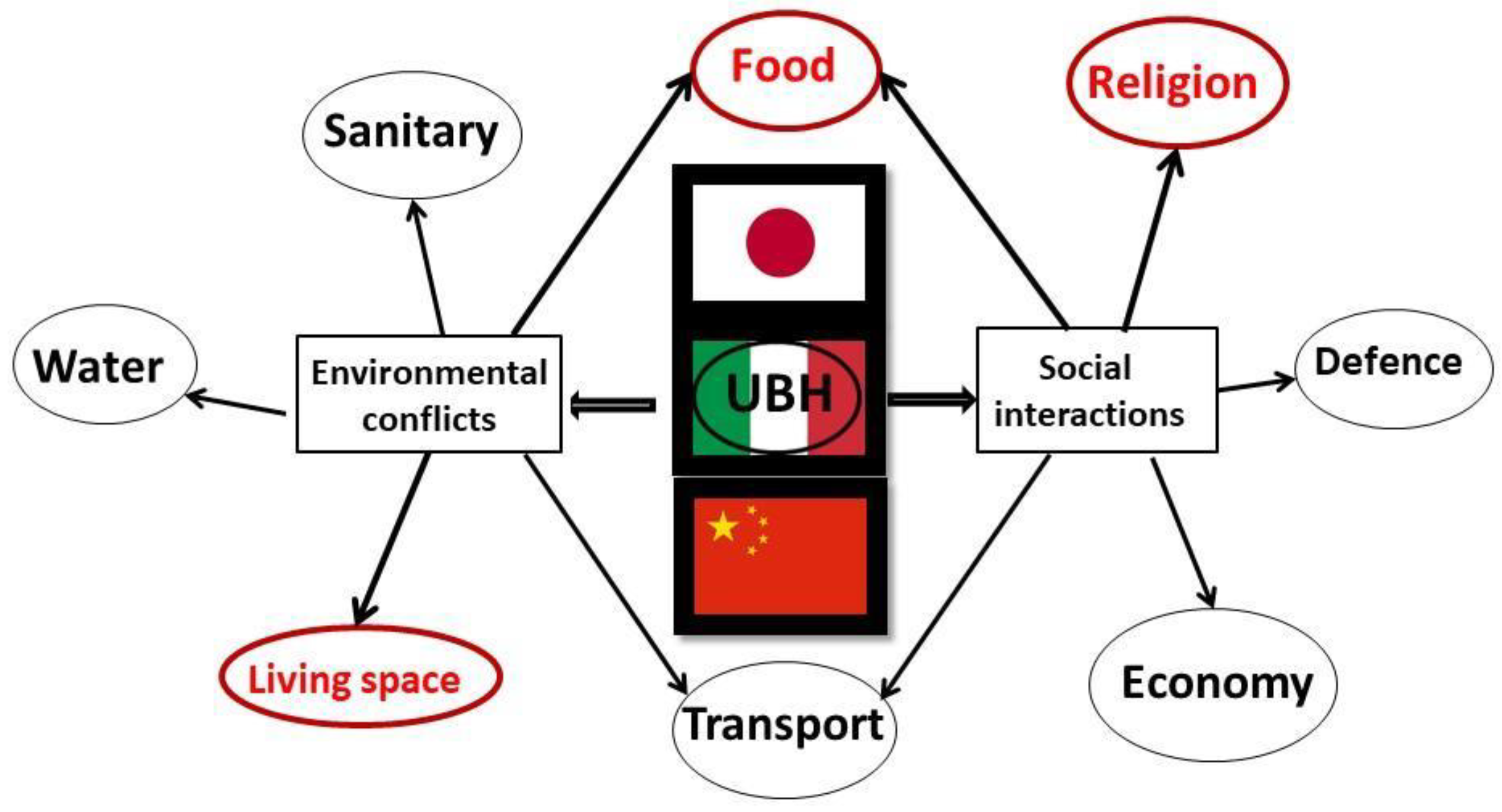
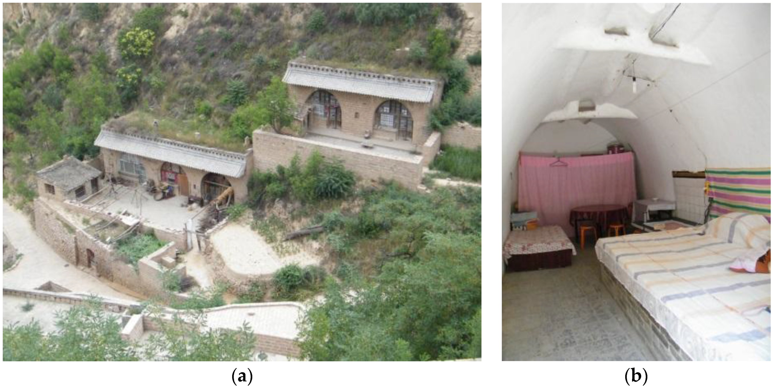
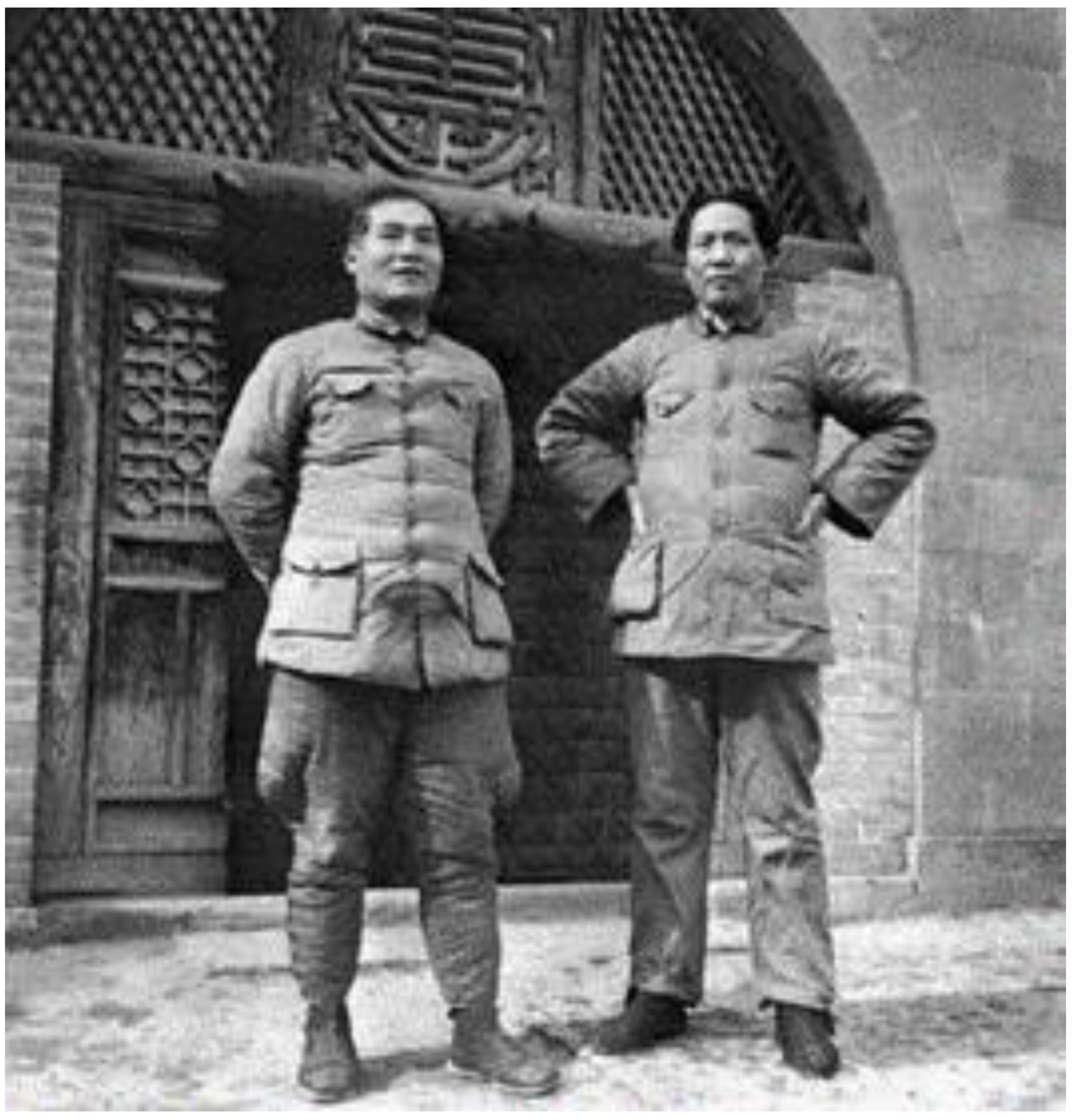
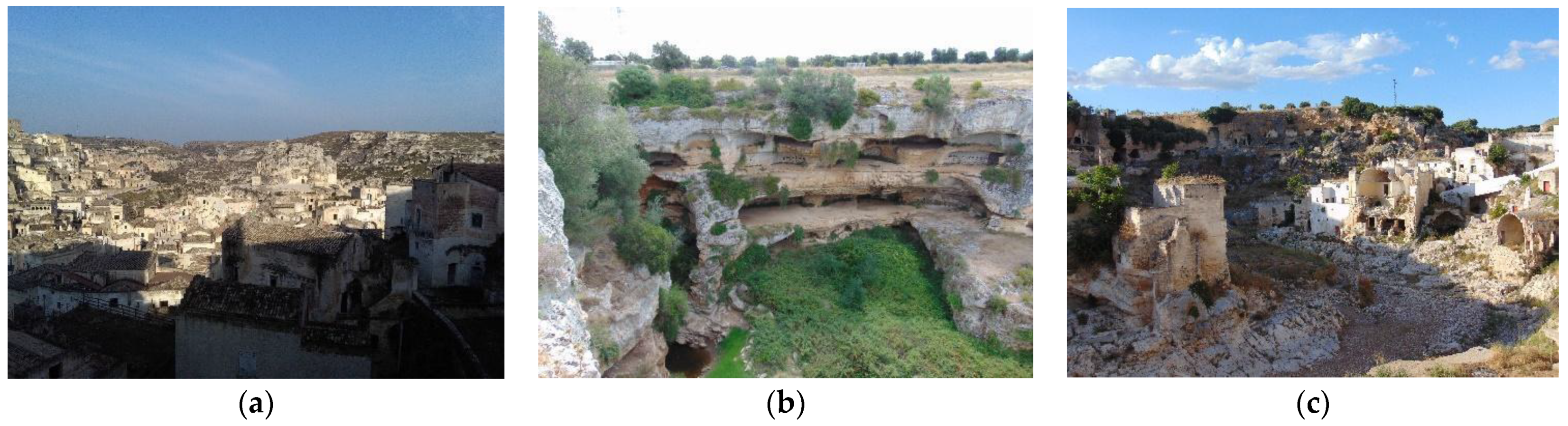
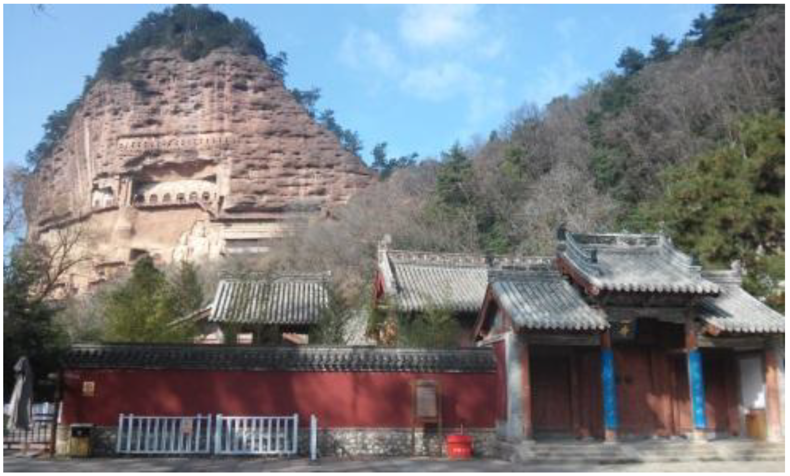
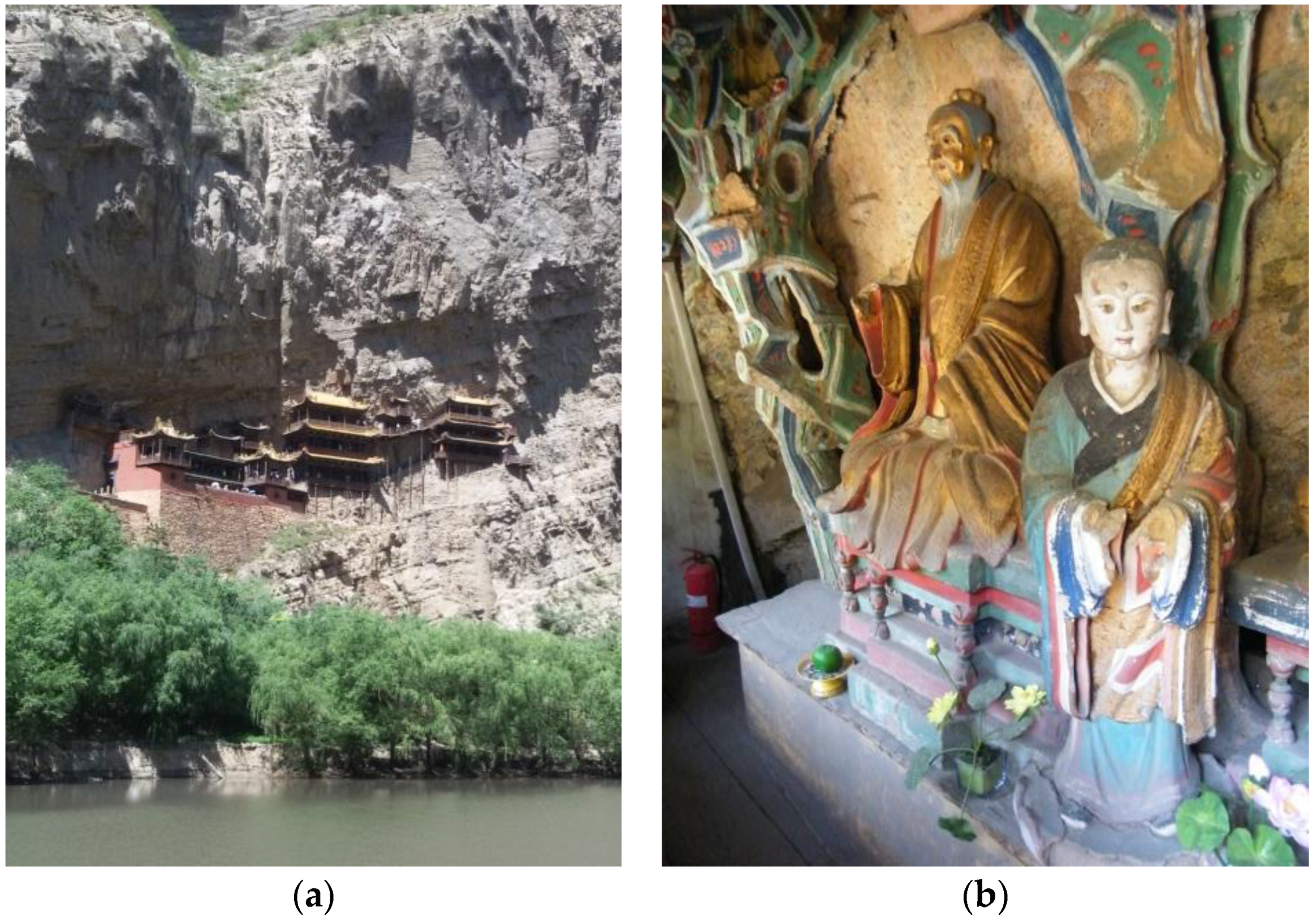
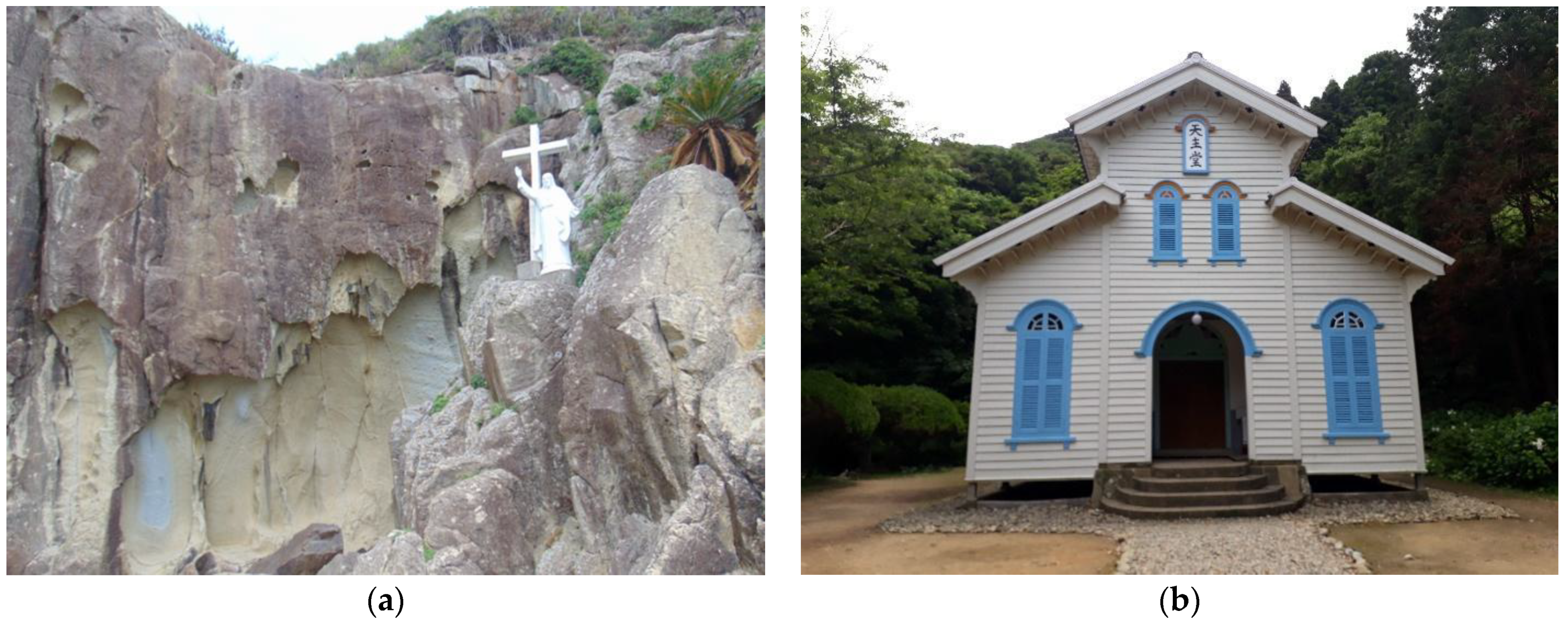
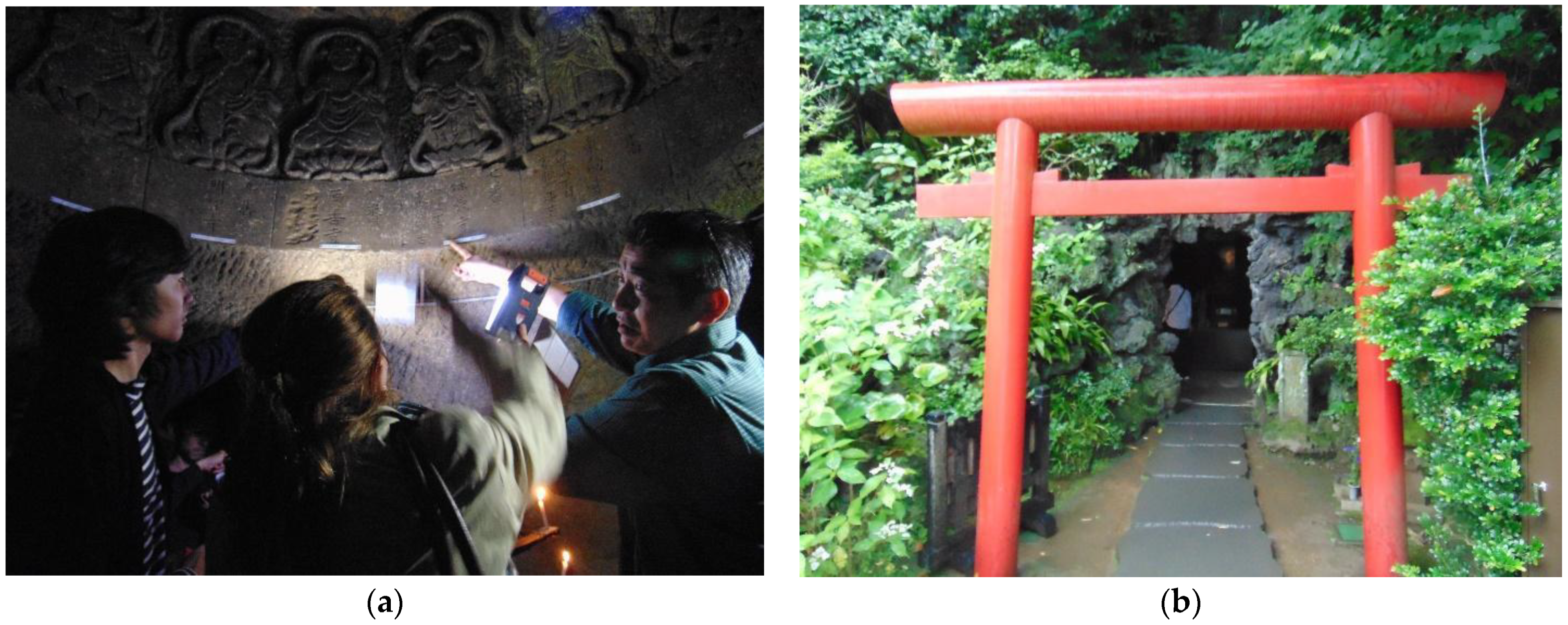
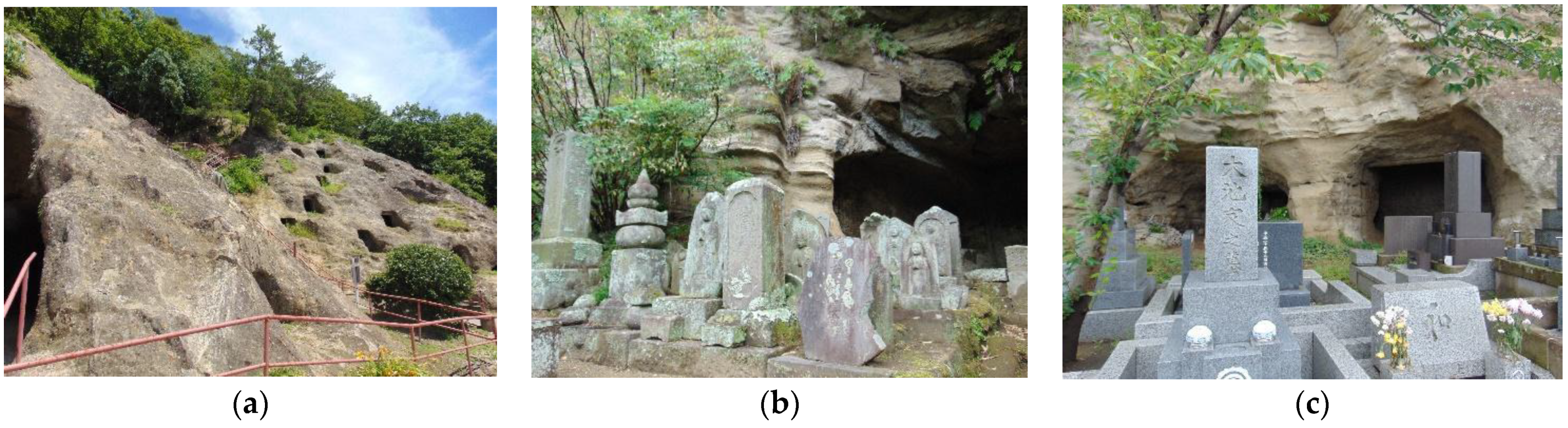
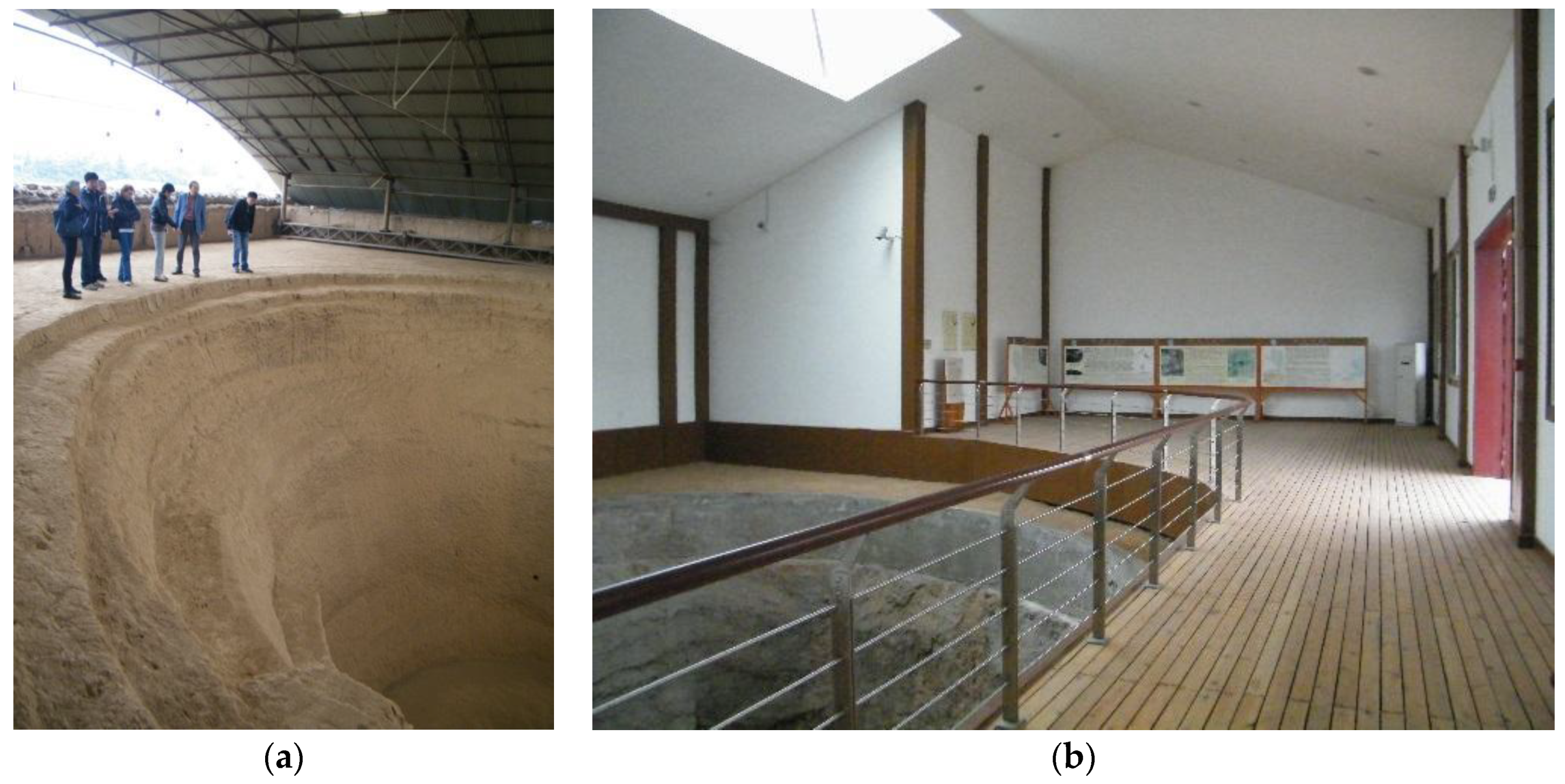
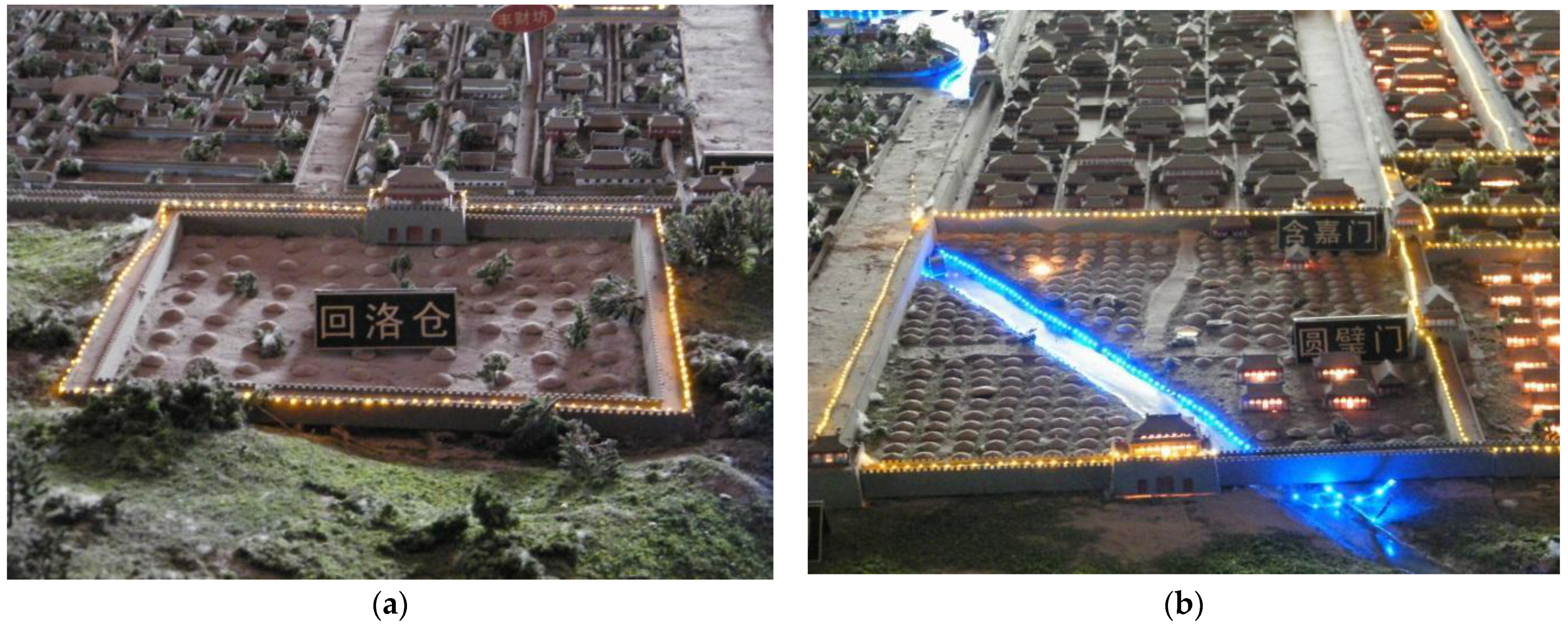
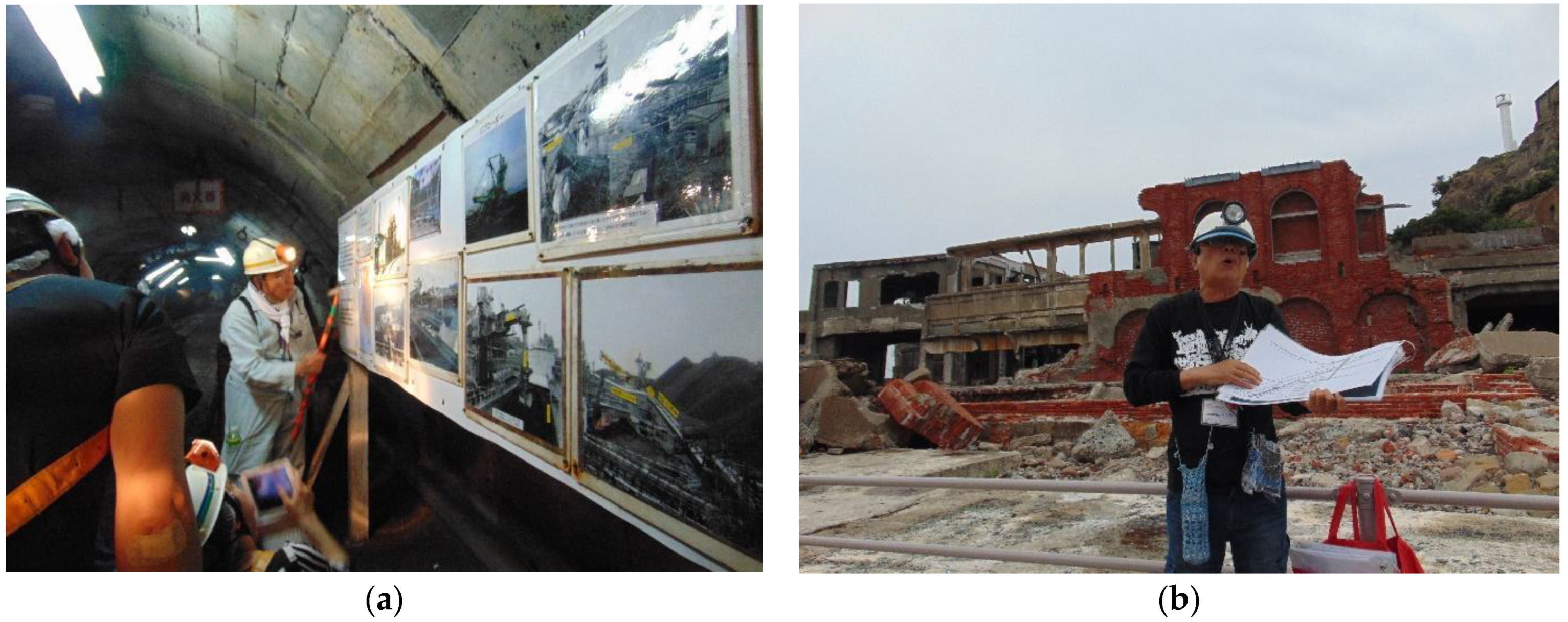
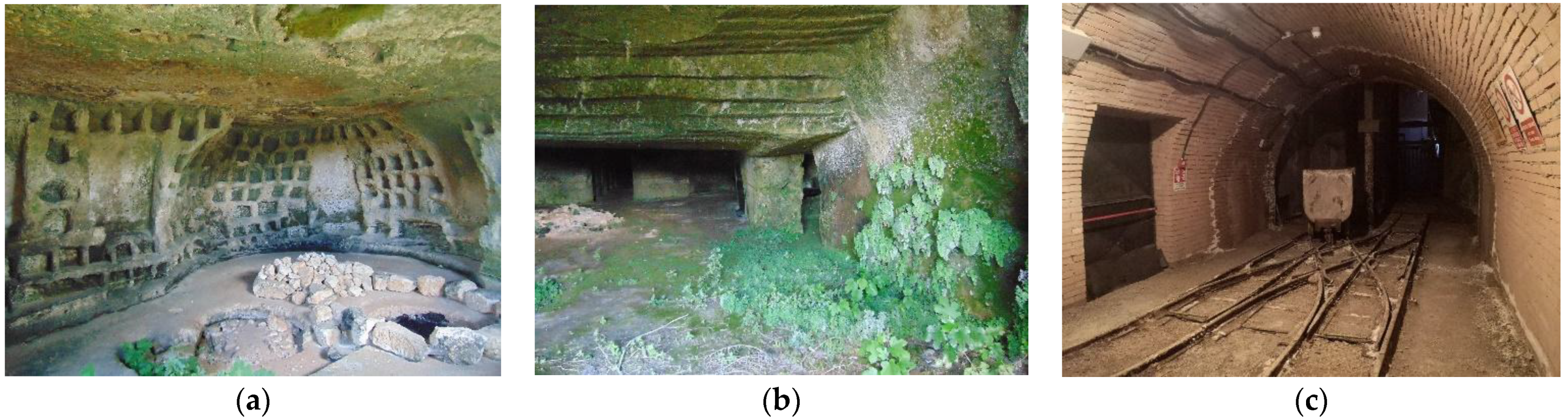
Table 1.
The “underground factor” in the descriptions of properties in China, Japan and Italy (updated 10 August 2021) (by R.V.).
Table 1.
The “underground factor” in the descriptions of properties in China, Japan and Italy (updated 10 August 2021) (by R.V.).
| Properties | UBH | C/N | Description |
|---|---|---|---|
| CHINA | C-N | ||
| Mausoleum of the First Qin Emperor | Burial place | C | Included |
| Mogao Caves | Buddha caves | C | Included |
| Peking Man Site at Zhoukoudian | Human fossils in limestone caves | C | Included |
| Mount Emei Scenic Area—Wudang Mountains temple with Taoist temple | Buddha caves | C | Included |
| Old Town of Lijiang | Water-supply system | C | Included |
| Dazu Rock Carvings | Buddha caves | C | Included |
| Ancient Villages in Southern Anhui—Xidi and Hongcun | Water systems | C | Included |
| Longmen Grottoes | Buddha caves | C | Included |
| Yungang Grottoes | Buddha caves | C | Included |
| Capital Cities and Tombs of the Ancient Koguryo Kingdom | Tumulus tombs | C | Included |
| Yin Xu | Burial place | C | Included |
| Mount Wutai | Buddha caves (Dunhuang caves) | C/N | Included |
| Site of Xanadu | Tombs | C | Included |
| Silk Roads: the Routes Network of Chang’an-Tianshan Corridor | Buddha caves | C | Included |
| The Grand Canal | Water systems | C | Included |
| Tusi Sites | Drainage ditches and tombs | C | Included |
| Zuojiang Huashan Rock Art Cultural Landscape | Rock art | C | Included |
| Archaeological Ruins of Liangzhu City | Burial place | C | Included |
| Quanzhou: Emporium of the World in Song-Yuan China | Burial place | C | Included |
| JAPAN | |||
| Hidden Christian Sites in the Nagasaki Region | Coastal caves as shelters | C | NOT INCLUDED |
| Iwami Ginzan Silver Mine and its Cultural Landscape | Mines | C | Included |
| Jomon Prehistoric Sites in Northern Japan | Burial place | C | Included |
| Mozu-Furuichi Kofun Group: Mounded Tombs of Ancient Japan | Burial place | C | Included |
| Sites of Japan’s Meiji Industrial Revolution | Mines | C | Included |
| ITALY | |||
| Rock Drawings in Valcamonica | Rock art | C | Included |
| Historic Centre of Rome | Burial places, catacombs, water networks | C | NOT INCLUDED |
| The Sassi and the Park of the Rupestrian Churches of Matera | Settlement, churches, water system | C | Included |
| Historic Centre of Naples | Caves, catacombs, tombs, galleries, water s., shelters | C | NOT INCLUDED |
| Historic Centre of Siena | Water systems | C | Included |
| Castel del Monte | Water systems | C | Included |
| Early Christian Monuments of Ravenna | Underground church | C | NOT INCLUDED |
| Historic Centre of the City of Pienza | Underground church | C | NOT INCLUDED |
| 18th-Century Royal Palace at Caserta | Water and energy systems | C | Included |
| Archaeological Areas of Pompei, Herculaneum and T. Annunziata | Water systems | C | NOT INCLUDED |
| Archaeological Area and the Patriarchal Basilica of Aquileia | Burial places | C | Included |
| Historic Centre of Urbino | Water systems | C | NOT INCLUDED |
| Villa Adriana | Underground galleries | C | Included |
| Assisi, the Basilica of San Francesco and Other Franciscan Sites | Religious caves | C | Included |
| Villa d’Este | Water systems | C | Included |
| Etruscan Necropolises of Cerveteri and Tarquinia | Burial places | C | Included |
| Syracuse and the Rocky Necropolis of Pantalica | Burial places | C | Included |
| Mantua and Sabbioneta | Shelters | C | NOT INCLUDED |
| Genoa: Le Strade Nuove and the system of the Palazzi dei Rolli | Shelters | C | NOT INCLUDED |
| Rhaetian Railway in the Albula / Bernina Landscapes | Tunnels and covered galleries | C | Included |
| Vineyard Landscape of Piedmont: Langhe-Roero and Monferrato | Cellars and storehouses | C | Included |
Table 2.
Valorization for UBH sites in China, Japan and Italy (by R.V. & L.G.).
| In Use/Dismissed | Reinventing | Reintroducing | Reinterpreting | Rebuilding | |
|---|---|---|---|---|---|
| CHINA | |||||
| Yaodongs | In Use/Dismissed | X | X | X | X |
| Granaries | Dismissed | X | |||
| Religious caves | In Use/Dismissed | X | |||
| ITALY | |||||
| Settlements | Dismissed | X | X | X | |
| Oil factories | Dismissed | X | |||
| Pharmacies | Dismissed | X | |||
| Bread ovens | In Use/Dismissed | X | X | ||
| Churches | Dismissed | X | |||
| Coal Mines | Dismissed | X | |||
| Burial Places | Dismissed | X | |||
| JAPAN | |||||
| Mines | Dismissed | X | |||
| Burial Places | Dismissed/In use | X | X | ||
| Religious galleries | Dismissed/In use | X |
Publisher’s Note: MDPI stays neutral with regard to jurisdictional claims in published maps and institutional affiliations. |
© 2021 by the authors. Licensee MDPI, Basel, Switzerland. This article is an open access article distributed under the terms and conditions of the Creative Commons Attribution (CC BY) license (https://creativecommons.org/licenses/by/4.0/).
Share and Cite
MDPI and ACS Style
Varriale, R.; Genovese, L. Underground Built Heritage (UBH) as Valuable Resource in China, Japan and Italy. Heritage 2021, 4, 3208-3237. https://0-doi-org.brum.beds.ac.uk/10.3390/heritage4040180
AMA Style
Varriale R, Genovese L. Underground Built Heritage (UBH) as Valuable Resource in China, Japan and Italy. Heritage. 2021; 4(4):3208-3237. https://0-doi-org.brum.beds.ac.uk/10.3390/heritage4040180
Chicago/Turabian StyleVarriale, Roberta, and Laura Genovese. 2021. "Underground Built Heritage (UBH) as Valuable Resource in China, Japan and Italy" Heritage 4, no. 4: 3208-3237. https://0-doi-org.brum.beds.ac.uk/10.3390/heritage4040180