1. Introduction
This year Greece is celebrating its 200th anniversary of independence from the Ottomans. The revolution of the year 1821 was the beginning of a ten-year fight which ended in 1830 with the proclamation of independence for the southernmost tip of the Greek peninsula. Immediately afterwards, a great effort started to rebuild the war-devastated land in the most celebrated contemporary fashion. The free Greek Lands and their cities were drastically remodeled in a way that bore no resemblance to their past ottoman looks. Or at least this was the intention. Neoclassicism prevailed across the newborn country erasing much of what was left from the older spatial forms. Priority was given to all signs demonstrating the ottoman rule such as mosques, palaces, and other public buildings that were in most cases completely demolished sooner or later. It was in many ways a landscape “Greekification” which tried to ignore what was there before. Changes were so drastic that within years after the revolution, most of the Greek cities of the free newborn state bore little resemblance to their ottoman form. This is perhaps the most recent and striking example of politically motivated spatial remodeling which Greek lands experienced. It is self-evident that neoclassicism and nationalism, the two leading esthetic and political ideologies of Europe, have penetrated the former Ottoman lands and are here to stay, freely and consciously chosen by the new state’s leading Elite [
1].
Following this example, one wonders whether there have been similar processes in the past, during the Ottoman period, when the expanding and flourishing empire conquered the Greek lands in the Balkans. Did the Ottomans transform the Greek rural and urban landscape following their practical needs, according to politically beneficial aesthetic and functional interventions? If so, what were the means for such interventions, and in which political discourses did they partake? What was their relation to former or contemporary forms of landscape formation? Those are the main research questions of this study which we hope to address. For the years that followed the Greek deliberation, ottoman spatial remains were considered as tokens of a backwards culture that did nothing but harm to the Greek lands. Nationalism is, of course, the key idea behind such cultural estimates which oversimplified and generalized some, perhaps negative aspects, or periods, to the expense of a much wider cultural experience of the Greeks. Contemporary historiography tends to see the Ottoman period beyond the lens of nationalism, be it Greek, Bulgarian, Serbian, etc. This trend acknowledges many aspects within this long period, stretching for some 600 years for some of the Balkan lands.
In spite, however, of the work done by the recent generation of historians which led to a far better understanding of the Ottoman Empire and the political balances in its various sub-periods, the under-evaluation of the cultural aspects of this period persists. Considering this, it is easy to understand why Ottoman landscape properties are still understudied and unacknowledged, much less promoted and celebrated like other cultural properties evident in the Greek landscape, deriving from older phases of Greek history. We hope that with this study we will be able to detect at least some of the characteristics of the ottoman intervention in space, explore the cognition behind them, and associate them with particular perceptions of the Ottoman elite about power and the role of the sultan within the Ottoman milieu. Such processes can be described as a rebranding of this heritage and the localities associated with it, helping to re-introduce it to the public, not as a token of a decadent phase of our history, but as elements manifesting deep cultural notions and political formations of the landscape, no less scientifically important to the rest already known.
This kind of rebranding or re-introducing of the heritage which is related more to the local evaluation of the Ottoman heritage is, of course, very important for us, but it is not the only one. Apart from this local space rebranding, one needs to consider a much wider one. That of the European history of the landscape, whose academic paradigm was dominated for centuries by the acknowledgment that the European perception of landscape begins in the 14th century by the Climb on the Mont Ventoux as narrated by Petrarch, a leading figure of early modern European culture. Without underestimating the significance of this text for the history of the European perception of landscape, we will later show how more or less in the same period in the Ottoman Thrace another interpretation of a local mountain top by early ottoman shamans reveals another perception for a European landscape.
Later misunderstandings also made things worse. George Simmel claimed that the notion of landscape was nonexistent in antiquity and the medieval ages, a statement highly controversial [
2]. Regardless of the fact that there can be no society with no spatial affiliation and therefore with no landscape narrative, Simmel overlooked a great deal of tokens of ancient and medieval culture that speak on a landscape perception. The difference is that they do not talk of his perception of landscape, the one that sees a part of nature detached from its surroundings and interpreted only in psychological terms. On the contrary, they reveal a great variety of landscape approaches, exactly as one would expect by so many societies developing in such extended territories around the Mediterranean and beyond.
Joachim Ritter also comments on the landscape perception, and insists that this was lacking in antiquity, attributing such a lacking to the holistic approach of the ancient philosophy which had no need of such partialized perceptions such as that of a landscape [
3]. However, this can also be debated since there are representations of landscapes from antiquity, which regardless of the differences in the artistic conventions they use, still demonstrate the existence of such notions. If one adds the fact that of a vast amount of works of art, the vast majority did not survive, then the argument about the nonexistence of landscape in antiquity becomes even more questionable.
Ernst Gombrich in his work also highlighted the various stages of development of landscape cognition basically using works of art from the Renaissance and later, to map a European perception of landscape [
4]. None of the above approaches are completely wrong in the sense that they describe or even construct a certain “biography” for the European landscape. However, all of them limit their reference material to visual representations and textural narratives ignoring architecture and the actual shaping of space. Furthermore, they ignore both the rich cultural past of Europe before the renaissance and its diachronic connections to other cultural areas such as the Near and Middle east. It seems to us that the basic failure of those thinkers is not so much the misinterpretation of their topic but the rather exclusive way of thinking about it. It might be that a certain European landscape-as they described it- exists, however it is not the only one nor is it unrelated to its past.
Drawing a new more inclusive paradigm for what is or should be considered as the European landscape is another intention of this research. We claim that the Ottoman culture, combining oriental and local elements produced a narrative for the landscape it holds politically, which is most significant to the occidental landscape example as described by the thinkers cited above. We also claim that due to its geographical location and therefore immediate contact with ancient landscape formations and surviving landscape traditions, the ottomans had at their disposal many spatial elements to use, which derived from the European ancient world. There are, therefore, in a sense carriers and innovators of the European ancient landscape tradition. Their close contacts with the renaissance world and their adaptation of various elements from it could perhaps open the discussion for considering them as one of the European variants of landscape traditions. Such an interpretation would be in our opinion closer to modern more inclusive cultural schemes as well as to the actual spatial formations themselves. Such a rebranding of the Ottoman landscape achievements is of crucial importance if one takes a quick look at the situation around us.
It is clear that the ongoing political and financial crisis constitutes mostly a conflict between the Western world (still politically central) and the Asiatic and African populations, a great number of them being of Muslim religious origin. This severe discord appears, in its worst expression, as immediate warfare or as a flux of terrorist attacks of the political periphery against the Western center. It is, moreover, accompanied by the arrival of huge numbers of refugees and immigrants in the Western countries and unfortunately, by the rise of racist activities in those countries of reception. Undoubtedly, it would be important to reply to this condition of instability in a number of ways yet, we shall choose among them the “unarmed” didactic approach of the anti-nationalistic didactics. This implies an approach that could prove the multi-ethnic identity of the largest part of our age-long knowledge and cultural experience.
Under this framework, we may present European civilization as the result of various highly differentiated approaches, many of which being of Western origin, but also in correlation to non-Western influences of Asiatic, Arab, Persian, and Ottoman provenance. It is well known that a part of the ancient Hellenic scriptures was meticulously preserved in the Arabic libraries. Charles-Louis Montesquieu critically presented 18th century France through the descriptions of two fictional Persian noblemen, in his Persian Letters, the ‘Lettres Persanes’, and during the same century, the neoteric European artistic and political references welcomed the seductive orientalism as well as the expression of the Ottomans’ “Sublime Porte” sovereignty. Already since the Renaissance, Europeans had to cultivate their approach to the Ottoman Empire, commemorating their cultural and political interest in depictions as those created by the Italian painter Gentile Bellini. This cultural osmosis could be investigated in many cultural fields simultaneously. However, it would be interesting to approach it in the very field of the earth substratum, or more precisely, in the cultural apperception of the landscape and its cultural transformation through agrarian cultivation, landscape, and garden art, as well as pictorial presentations. It is well known that the Middle East and Minor Asian territories, along with the Persian and Arabic countries, had already demonstrated a concrete landscape approach (combined with garden art techniques) even before the arrival of the Turkish nomadic tribes and it was this approach that was infiltrated in the Moorish gardens of Spain. The Byzantine era was also well-known for its unique landscape experience, largely correlated to a religious symbolic perception of the universe [
5]. Ottomans inherited those aforementioned traditions and developed them even more, in their own cultural way, further inscribed in the extended lands of their governance.
Generally, we have just described a multi-layered palimpsest of cultural sequences that surely left their traces on the earth’s surface. It is according to Gilles Deleuze and Félix Guattari that the feeling of “gaia” (earth), of the landscape in our own approach, should be detached from the earth bas-relief in order to create abstract mental formations i.e., cultural conceptual formations [
6]. Then, those mental formations may return again on earth to be installed as material creations. Similar cultural approaches travelled from the Asiatic steppes to the Mediterranean periphery and the Balkans, and were finally, re-materialized in the Ottoman gardens and the Ottoman architecture. The Ottoman Empire was a multicultural empire and so were the Byzantium and Arabic worlds. Our contemporary world is also multicultural, and our societies have to realize and accept this reality, they have to be informed and culturally trained about it, by looking both towards the future as well as backwards towards the historic past.
Finally, regarding the significance of the creation of a ‘smart’ virtual approach towards our two aforementioned arguments, we have already described an “ontology” of attributes and concepts, which may be interrelated in a three-layered way. This would involve firstly, a “rhizomatic” multi-oriented association connecting religious feeling, social or political ethics, and philosophical conceptualization. On a second level, it would refer to the way that landscape apperception was connected to landscape art and landscape and garden formations. Then it would lastly lead to the correlation of landscape feeling and landscape formations of the Hellenistic period, with Byzantium and Arabic worlds and then with the Ottoman period.
2. The Aim of the Research
The basic aim of this research is to explore the way Ottomans experienced and interpreted the Greek landscape, in order to propagate the imperial ideology throughout the entire Ottoman period up until the early 19th century. Furthermore, it is of equal importance for this study to highlight the similarities as well as the differences among the Ottoman landscape perceptions and those which preceded them in the Greek territory since the Hellenistic era.
Undoubtedly, the Ottomans had a multi-layered landscape perception firstly, due to their nomadic background in Central Asia and the Shamanic culture prevailing there, secondly due to the Islamic notion of the world, and finally, due to the Persian culture well imbedded in them since their early contact with the region of the Middle East. All of the above layers of landscape culture could be traced in the respective ottoman heritage; the shamanic one through the importance attributed to pre-existing sanctified places with multiple water features and impressive vertical elements (trees, mountains, stone slabs etc.) [
7]. The Islamic layer is present also in the importance of water surfaces while the more mystical Persian one, through the reflection of often Persian architecture on the water surfaces, recalling doctrines of Islamic mysticism [
8]. To those layers of landscape tradition, one could also add the Western Renaissance influences reaching the Ottoman court in the 15th century (as evident in the Top Kapi Palace and the provisions for its visual contact with its surroundings) and infiltrated through the Ottoman architectural and artistic expression [
9].
All those cultural associations produced a complex and intriguing landscape interpretation, in close relation to the political and imperial ideology of that time. Such ideas, however, were not brand new to the region where since the Hellenistic era, the impact of political ideologies into the landscape formations, mostly in the major Greek urban hubs of the Eastern Mediterranean basin, such as Alexandria, Antioch, and Rhodes, was evident. The Byzantine landscape and garden art heritage was in many ways a continuation of pre-existing ancient traditions already known to the Ottomans, since their early days in Bithynia. The study of the apperception of landscape in Greece by the Ottomans requires taking a step back and examining the notion of landscape and its perceptions by the Byzantines, acknowledging both nations’ common understandings of nature and the cosmos as distinctively symbolic and sacred [
10]. For the Byzantines, as well as the Ottomans, nature was perceived as a system of symbols created by a divine power to facilitate communication with humanity. Thus, landscape elements reflected this “heavenly reality” [
5] humans shared with a divine power and in that sense, those elements required the symbolic participation of both parties. Moreover, what is particularly interesting in the Byzantine perception, which was probably acknowledged by the Ottomans, was the symbolic interpretation of the landscape in religious terms, according to which various plants had specific meaning related to the spiritual (religious) life [
11]. Such plants, like the Cypress, are often encountered in the Ottoman landscape culture as well, with similar symbolic properties.
Undoubtedly, in contrast to the ottoman architecture, very few scholars have researched the topic of landscape perceptions by the Ottomans, although publications on ottoman gardens have appeared already since the ‘70s [
12]. It was in the late ‘90s when Nurhan Atasoy published his work that a more integrated approach on this topic appeared, interlinking architecture, gardening, visual representations, and artistic artifacts, in an effort to capture the “love” of the ottomans for nature, flowers and landscaping [
13]. Shortly after, Heath Lowry referred extensively in his work to the landscape properties that excited the Ottomans so much that they used to erect structures (usually mosques) in order to manifest their aesthetic appreciation of the landscape [
14]. In Lawry’s work, one sees the importance of the symbolism of trees for the Ottoman culture, and miraculously, several (sacred) spaces still survive within their original natural surroundings.
In general though, the ottoman literature used for the research was primarily based on historical maps, 19th-century photos, old postal cards, and travel such as that of Evliya Celebi, as well as of other travelers and natives from the 17th century onwards. Those sources have allowed the partial reconstruction of the “original” surroundings in each case study yet, the “in situ” investigation supplemented to a great extent the formation of a narrative regarding landscape perceptions and aesthetic evaluations of that time.
However, what was lacking from this perspective was the association of visual elements and architectural properties to the political ideology of the ottoman court and potential social protests. This is completely unsurprising, should one consider that up until recently, the topic of the ottoman political ideology was totally neglected and thus, all related literature was deficient. Over the last ten years, a few relevant books have appeared, which allowed us to have a more comprehensive overview on that subject [
15,
16].
Therefore, the methodological approach is based exactly on that theoretical framework related to the landscape apperception by the Ottomans, which as it has been described before, reflects their cultural adjustment to the palimpsest of landscape traditions in the Greek territory. Towards this aim, the current research focused on the thorough study of the extensive literature (historiography of ottoman cities, surveys of travel narratives, poetry, geographical maps etc.) as well as the depiction of landscape in various forms of art representation (mural paintings, paintings, miniatures, art objects etc.). This theoretical review has been informed by the findings of the “in situ” survey in selected case studies across Greece, which highlights the aforementioned ottoman perceptions in terms of the way each architectural monument/complex is integrated into the landscape.
The selection of those case studies is not random, it is based on their geographical allocation, the degree of their preservation, and their contribution to the aim of this research and the issues to be explored. The architectural documentation and representation of those case studies will supplement the theoretical framework with observations that ultimately attest to the initial statement of this research referring to the central political role the Ottomans attributed to the landscape in Greece. Undoubtedly and in direct relation to the Hellenistic era, the landscape defined the architectural planning in the Ottoman period, reflecting the political and financial power of the Empire as well as the prevailing social values and ethics.
Therefore, in terms of the methodological approach adopted in the current research, it is through this combined process of the theoretical investigation informing the fieldwork and vice-versa that the results of this research not only could be valid and scientifically proven but also, they could form the basis of a larger study, extending beyond the Greek territory.
3. Results and Discussion
The Ottoman cultural framework is characterized by two equal forces that have shaped the cultural imprint of the Ottomans: on one hand, the Turkish tradition of animism, and on the other hand, the mystical Islam, accompanied by Neo-platonic interpretations of the world. These forces are manifested into the landscape reflecting the emerging political ideologies, the financial power, and the imperial glory of the Ottomans.
This central political role of landscape in the formation of a nation’s cultural identity is definitely not a new concept. It derives from the Hellenistic era, when Hellenistic cities and in particular, ancient Messene, “demonstrate an intentionally processed landscape approach since through a specific urban planning system (Hippodamian), the public buildings are correlated to the surrounding landscape, in such a way so that the state structures of the city along with its economic power can be portrayed” [
17].
In an attempt to highlight this political role of the landscape interrelated to social structures, six case studies have been selected for in situ investigation. This selection was based on certain criteria, related to the aforementioned tradition of animism as well as the Islamic mysticism, which became early on an integrated part of the Ottoman royal ideology [
15]. As such, a mystified sense was attributed to the royal grounds and parks, enhanced by various structures and activities within their boundaries. Later on, along with the major political and social changes of the 17th century, Ottoman landscape perception was modified, converting into more “constitutional” interpretations of landscape, implemented in the numerous gardens of that period. Under this theoretical framework, the selected case studies include an early Ottoman Tekke in Rousa (14th cent.), one in the Ottoman city of Yannitsa (15th cent.), two case studies in Serres (late 15th and 17th cent.), a case study in Trikala (17th cent.) and the park of Rodini in Rhodes Island (16th cent.) (
Figure 1).
The Case Studies
3.1. The Case of Rousa in Evros
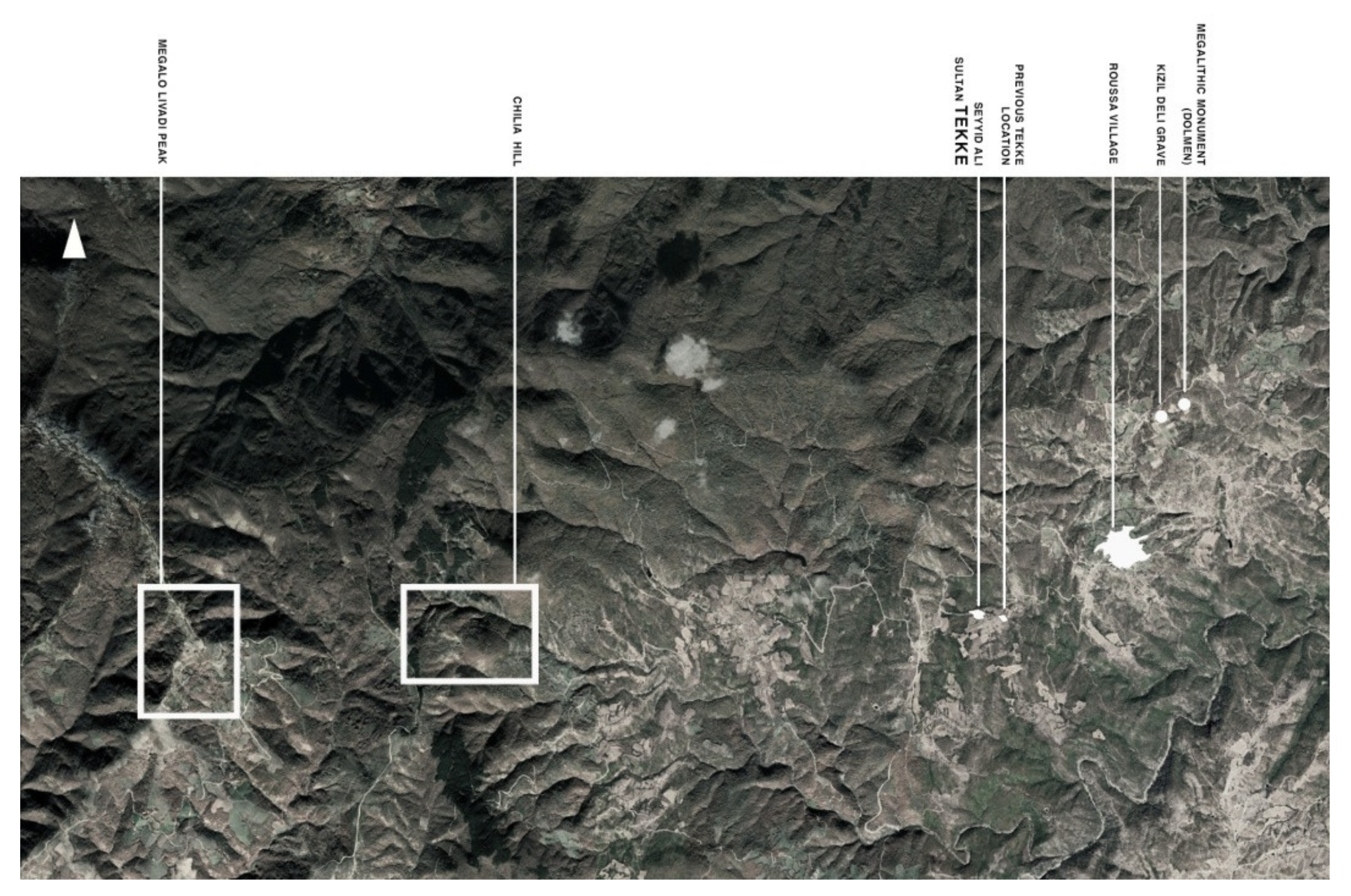
According to existing Ottoman archival sources, the Tekke located near the village of Rousa in Evros, was founded by Seyyid Ali in 1402 [
18]. In our opinion, however, this Early Ottoman institution can be dated a bit earlier, around the 1360s, a decade in which the Ottomans prevailed in the Thracian region. Seyyid Ali was an important leader of those Ottoman groups, known as “Sheikh”, “Baba”, or “Sultan” that combined the central Asian shamanic tradition as well as the tradition of mystical Islam. The Ottoman dynasty significantly counted on their help to conquer Thrace, at a time when no regular Ottoman army existed and moreover, depended on them in order to maintain peace and generate development in rural areas after the conquest. It is, therefore, more likely that the site was originally settled by ottoman shaman-dervishes about half a century earlier than the date its endorsement document suggests.
According to the founding legend of the site, Seyyid Ali was on the top of the nearby secret mountain which overlooks the nearby valleys, and which bares archeological evidence of worshiping rituals since the Iron Age—still evident nowadays, when he threw a burning stick which landed a few kilometers away [
19,
20,
21]. That was the spot where his followers and himself settled and that was also, the place of his burial, close to ancient iron age megalithic tombs, surrounded by oak trees, a kind of plant particularly venerated as ever-growing.
The place chosen by Seyyid Ali was not random, as it was full of reminiscences of older worships reaching as far as the Iron Age. This element provided him with an already sanctified ground, where Seyyid Ali’s tomb was placed after his death, next to pre-existing ancient ones venerated by the locals [
14]. This location was also at the crossroads of transport and trade routes, combining the fertile yet limited agricultural land with the prevailing hunting opportunities of the mountainous area. This evaluation of the pre-existing landscape elements reflects the cultural background of the early Ottomans and their followers, with a specific reference to shamanism in particular.
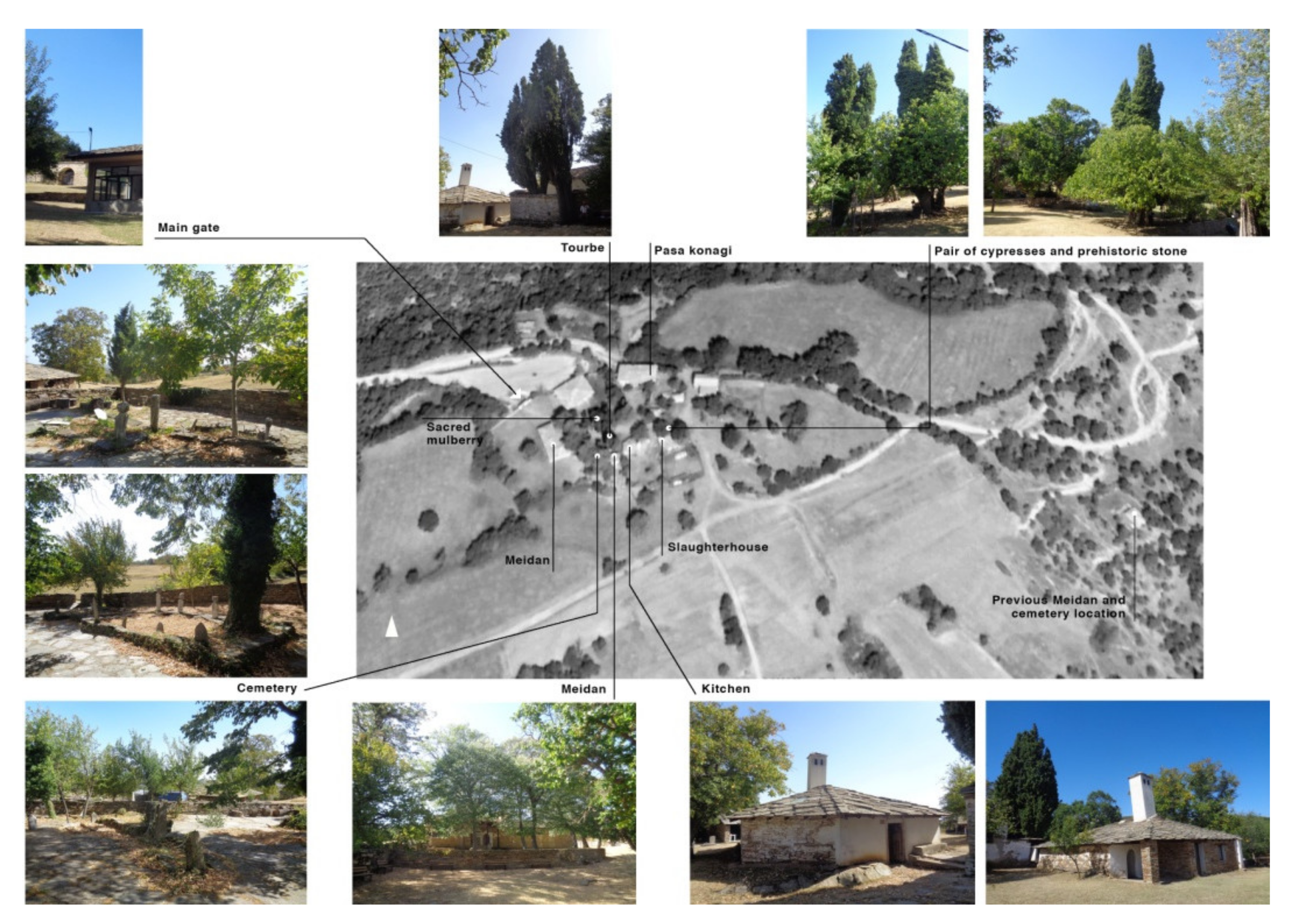
However, the gradual institutionalization of the foundation and its close association to the Bektashi Shrine in the late 15th century had a spatial impact, in terms of the relocation of the venerated grave of the shaman/sheikh to the southern part of the village. There one meets with two locations, separated only by 1 km of dusty road. The one to the east is much humbler and considering the date on the gravestones around, older than the second on to the west, where the grave is to be found now, surrounded by symbolic vegetation such as cypresses, standing for eternity and a “bleeding” mulberry tree, a reminiscent of the warlike character of the place’s users. The date on the gravestones and the architecture and vegetation date, all signify that this is a place developed in the 18th century onwards. This triple location of the venerated tomb of the sheikh matches very well with the political ideology of each period of their creation. The originally simple and nature-like open-air tomb of the early days, later institutionalized and replaced by a veneration spot more architecturally “present”, signifies the gradual incorporation of the local order by the larger one, that of the Bektashi, which in their turn, had close political affiliations with the ottoman establishment since the 15th century. Later, when the turmoil of the 17th century and the kadizadeli movement and its criticism towards old orders drastically changed those old ties, one can identify the veneration spot moving a bit further from its previous spot, an indication that balances among the old members of the order and the new ones, had changed [
22,
23].
This case study reflects the archetypical spatial perception by the Ottomans with symbolic connotations, attributing architectural functions into the natural elements, thus rendering the landscape ‘sacred’. By using particular natural elements, unique viewsheds, and the spatial association with older sacred spots, early Ottomans created a new configuration of spatial meanings and newly introduced concepts yet bound to the pre-existing genius loci. Furthermore, they shape space according to political and ideological changes that influence the local group of Sufis. The bond with the established order of the Βektashi led to a reinterpretation of their surrounding landscape and the need for a more enclosed set of spatial elements away from the popular path and the nearby villages, and perhaps more importantly, close to the order’s property in the region. In this particular case study, one could pinpoint both the original state of early ottoman mystified landscape as well as its gradual institutionalization following an affiliation with a “court order” such as the Bektashi, which, with their incorporation of the ottoman social apparatus, were providing among others, justification for the sultan power, based on their mystical interpretation of God and his representative on earth. In other words, at more or less the same period when in southern France, Petrarch was planning to climb his mountain, in an endeavor with strong mystical connotations as well, related to one’s life path and its effort to reach the divine, on the eastern tip of Europe, in Thrace, a Turkish shaman has reached his mountain top and established an interconnected set of locations around it for his followers and himself, also providing a mystical interpretation for his choices.
Both examples operate in parallel, as they incorporate a mystical interpretation, considering that religious mysticism was not unknown in Western Europe at the time, just like in the east. However, they could also be, regarded as opposites, since the first one describes the intention to climb the mountain in order to see the view, while the second one is already re-ordering the meaning of the surroundings from the mountain top. In other words, the first is bottom-up while the second one is top–down oriented. This is perhaps due to the difference in the cultural context; while Petrarch’s religious humanism is focusing on the human to reach the divine, in this case study, it is the intermediate between the divine and the secular which defines the order of the meaning of things (
Figure 2 and
Figure 3).
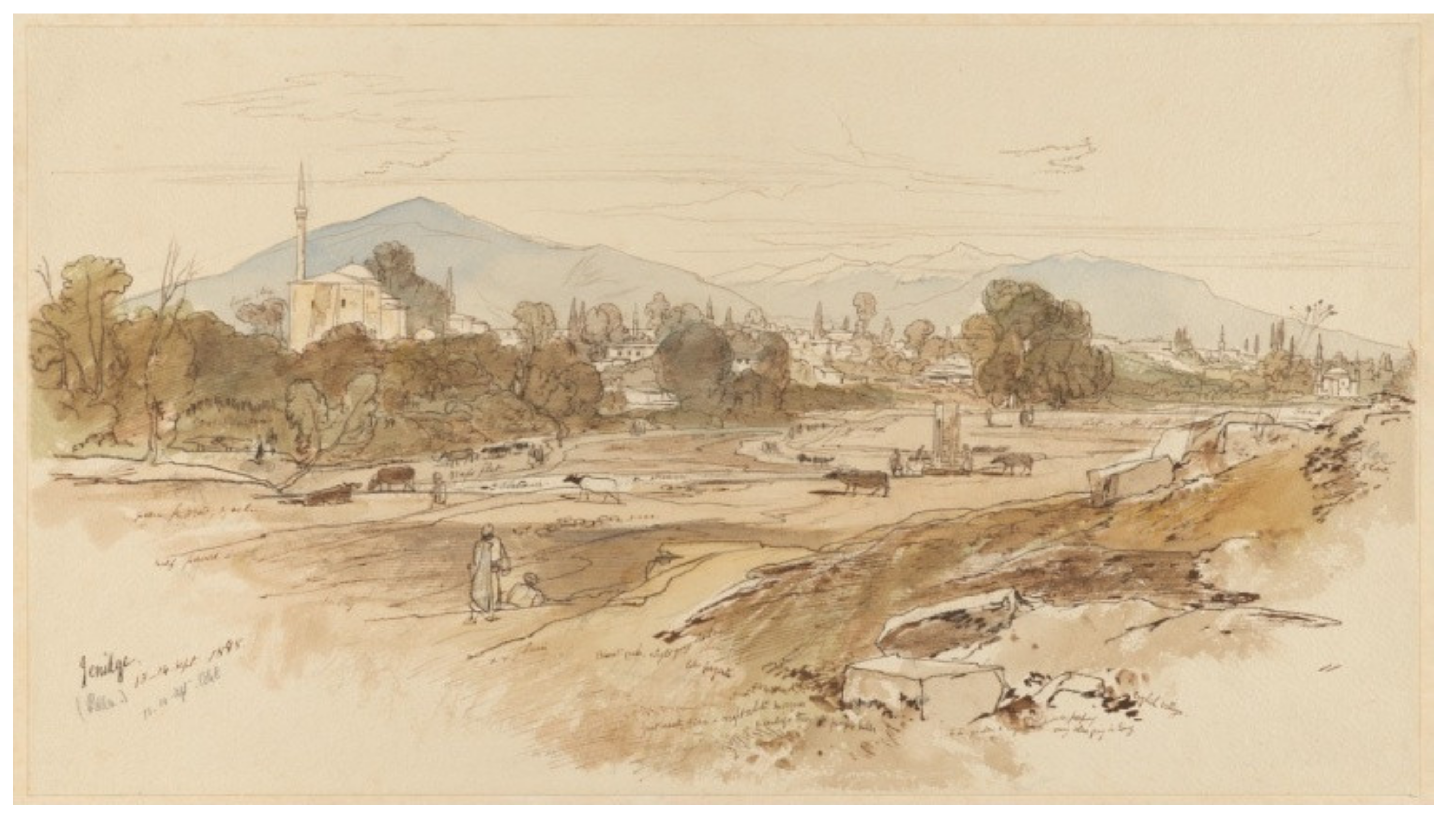
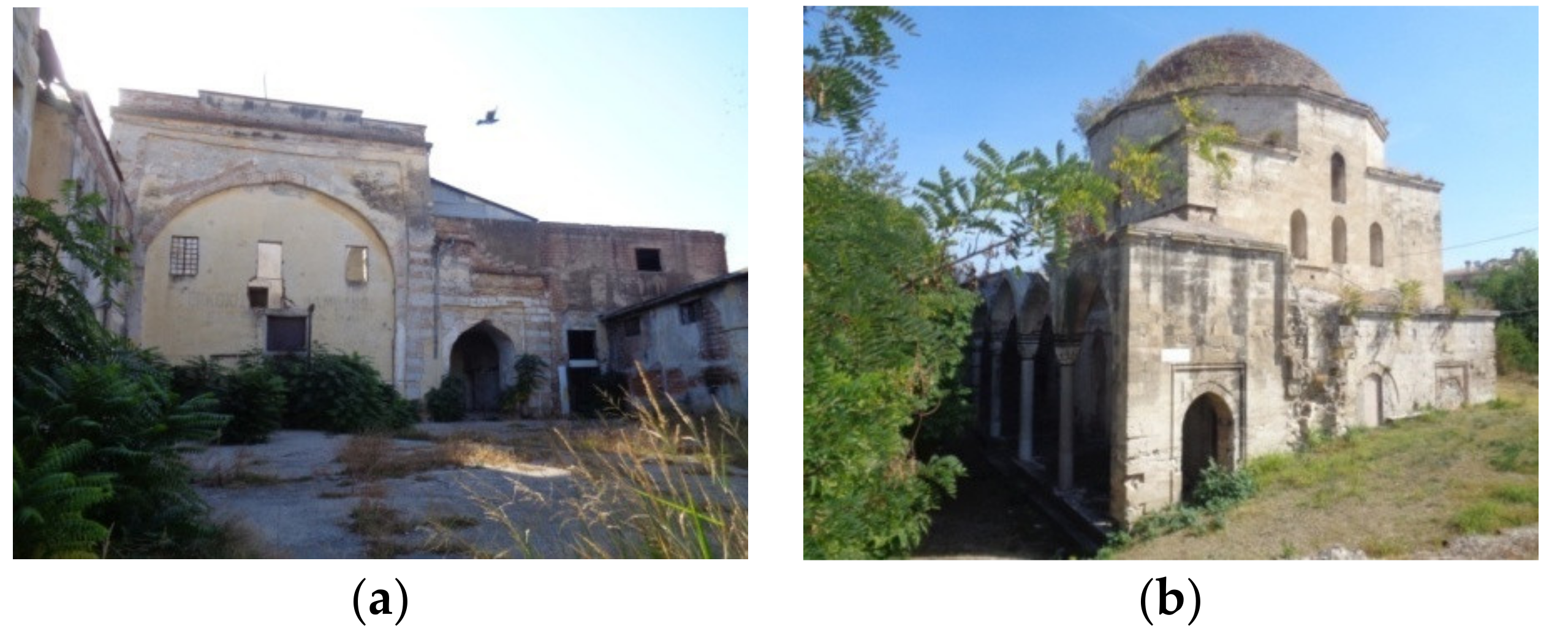
3.2. The Case of Yannitsa in Macedonia
The city of Yannitsa located to the north-west of Thessaloniki, was founded by the Ottoman warlord of Christian background Evrenos Bey, around 1385 and soon became his capital, due to the natural advantages of the location. These included the fertile plain, suitable for gathering and feeding thousands of warriors, the now drained lake of Yannitsa which was a considerable water and food source, and the nearby mountain Paiko, providing wood and fields for livestock. The city of Yannitsa itself was constructed over a row of low hills starching from the lake’s shores to the north, towards the mountain Paiko.
The original establishment of the city in the late 14th century by Evrenos Bey also included a vivid market, considering that Yannitsa was the center of his extended domains olla across Macedonia and Thrace. One of the basic components of an ottoman market city at the time was the tanners since the provision and exploitation of leather was one of the most vivid industries, closely related to the nomadic life of a great part of the early ottoman society. Related to this last activity, the pre-existing community of the tanners in Yannitsa, which was known for their support to “akhis” (urban brotherhoods) and their tendency to operate independently from any ruler, constituted a challenge for the establishment of the new city [
24]. Indeed, we know that this particular group of artisans was connected to the foundation of akhi urban brotherhoods, which had their own resources deriving from the member’s contribution and their own venues, coming into sharp contrast with the sultanic model of donations of land in exchange for political support. Due to this policy and to the organization of market guilds, the Ottoman Sultan, from the 15th century onwards managed to control the urban markets. In this way, the social role of the akhi brotherhoods within the Ottoman reality gradually declined, allowing for the early Ottoman quild-like trade to flourish around an organized Ottoman marketplace (Bazzar).
Such a kind of market organization started to operate in Yannitsa in the 15th century under the patronage of Evrenos and his descendants. Next to it, probably around 1430, a major mosque was built in celebration of the conquest of Thessaloniki by the Ottomans. It was erected in the southern hilltop, close to the shore of the lake of Yannitsa, on the surface of which the building was reflected, when seen from afar. The structure survives until today, heavily altered. It went through many faces, starting as Namazgah, namely a freestanding open structure covering only the place for the mihrab. Such structures are related to their environment visually as well as functionally since the actual praying takes place in the open air. Such a portico-like free-standing structure was later, probably in the early 16th century, expanded and reshaped as an impressive domed mosque [
25].
It is very probable that the place for its erection was not socially empty before hands. Close to the tanner’s quarter near the lake and rising just over it, it could have functioned indeed as a place for paying and gathering for social activities and discussions. It was in the interest of the descendants of Evrenos to “occupy” such a place with their own symbol of power, overshadowing their social rivals. In this case, the mosque became a landmark dominating the surrounding landscape, as it could easily be seen by anyone approaching the city either by boat or on foot (
Figure 4). At first sight, it also marked the victory of the organized Ottoman markets over smaller older professional groups, such as the tanners and their neighborhood-based social layout. This bold spatial intervention in the landscape had a huge significance to the local (and regional) community, glorifying the military character and predominance of the Ottoman power in the Balkans, considering the military nature of the Evrenos clan and the monuments probably associated with the ottoman final capture of Thessaloniki. Its later transformation into a proper Friday Mosque took place when the relations among those early Ottoman elite families and the sultan were renegotiated, as it became clear by their patronage practices.
In this case, there is an extra layer of “perception” of the monument and the landscape around it; the intention of a local noble family to erect in its territory monuments that reflect the power of the ruler. In this case, a rural clan is appropriating the imperial architectural and visual language to promote its own power capacities, which constitutes a bold political statement in the landscape. Furthermore, standing on the hill, with its reflection on the lake’s surface at its feet, widely open to the surrounding landscape in its original phase, through the great arches on its façade, this early Ottoman namazgah structure fits very well into the barzakh notion of space, a mystical concept embraced by the Ottomans. According to this notion, barzakh is a place right at the fringe of two colliding spheres or elements, be it water and earth, which is considered as a prominent place for communicating with the divine which can be manifested only at that spot [
8].
Considering this popular notion, the erection of this structure in that location fulfils all relevant criteria and clearly shows the use of mystical concepts into early Ottoman architecture by the elite to highlight its power. The erection of the namazgah on the site’s most prominent vertical element, the hill, also shows considerable incorporation of shamanic ideas, which also included the use of water as a means to transcend time and cosmic spheres. This monument holds more than one layer of landscape interpretation, all manifested in one single architectural expression, which in the course of time changed shape many times, not always for the best.
3.3. The Case of Mehmet Bey Mosque in Serres
Serres was an important city overtaken by the Ottomans in 1383. The location of the city on the route from the Aegean Sea to the northern Balkans along with its very fertile grounds allowed for a burst in the development of trade and crafts. This tradition also continued under the Ottomans, with the difference being that the city expanded outside and around its old medieval fortification, centered now on a major and well-organized Ottoman bazaar, which reached its peak after the middle of the 15th century, pretty much like in the same process of sultanic control of the markets described before. This radical change in the financial and spatial layout was interlinked to the need of the old craft neighborhood-based brotherhoods to relocate to a less centrally controlled space in order to perform their craft rituals. Such places around Ottoman cities, well-known for their natural beauty, were called “mesires” and one of them was to be found right to the east of the city of Serres, along the local stream (
Figure 5). However, even this “extra muros” place would not escape the social control of the Ottoman dynasty and its conflicts with other social factors such as the urban brotherhood members.
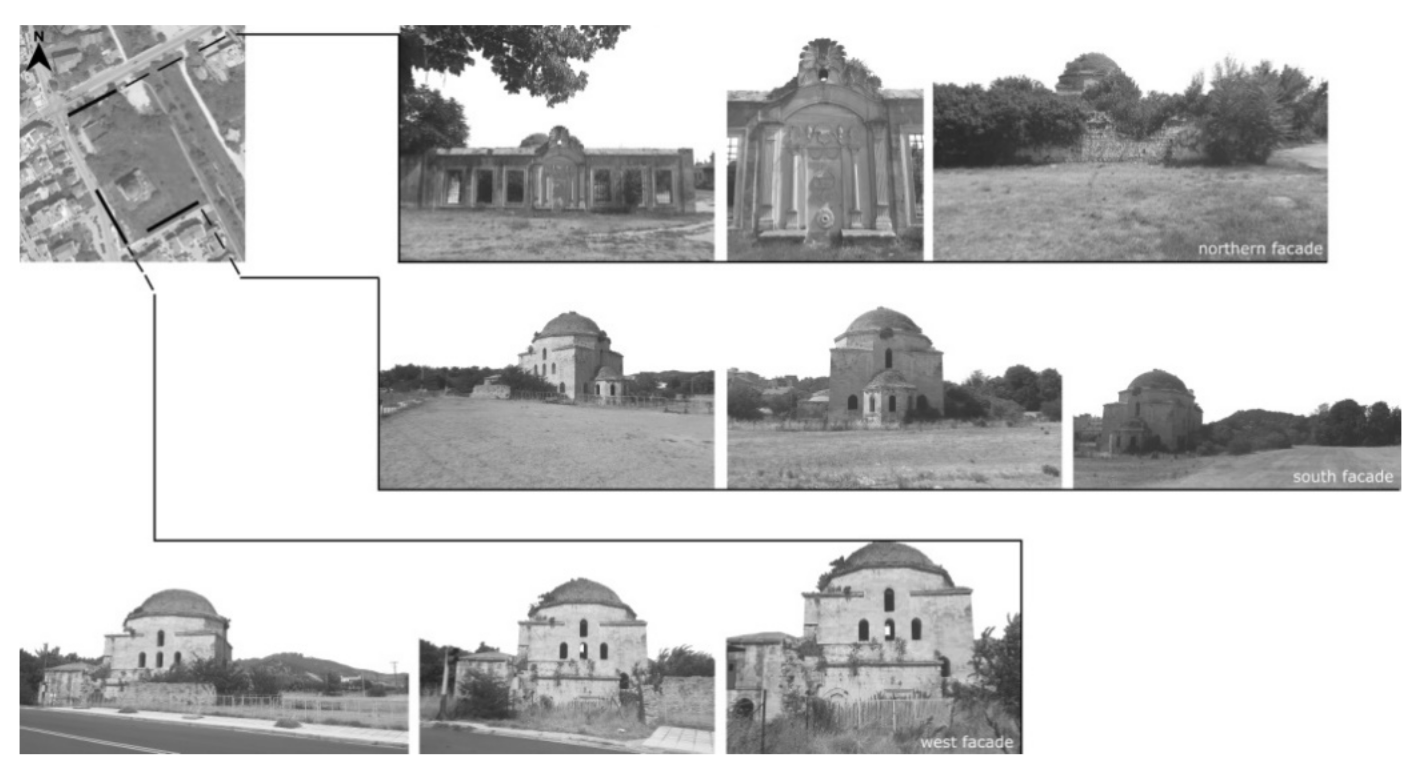
At the end of the century, a new massive mosque was erected under the patronage of a member of the royal court, based on recent architectural achievements in Istanbul, altering forever the social use of this place [
26]. The geometry of the monument embodies the order and stability of the state, while the various shapes that constitute the monument (cube, octagon, hemispheric dome) refer to a particular aspect of spatial integration. Namely, the four corners of the universe (cube) symbolize the five obligations of man to God, including praying five times a day (dodecagonal drum, a shape whose base is the pentagon) and the divine domain (dome) [
27]. The creation of such an explicit example of royal patronage in an otherwise unpopulated area reached by the city only by a bridge, reveals the political intentions behind such an initiative, as there is no practical point in investing such effort and expenses for such a structure on this spot.
The monument is erected in a meadow crossed by a water stream, surrounded by thick vegetation as well as cultivations slightly further away. At least this is the way the place was described by Evliya Celebi, maintaining however still some aspects of this natural landscape around it. In this case, the basic elements of an ideal Ottoman landscape are revealed, such as a flowered meadow nearby a river or a stream, supplemented by a strictly geometrical structure that reflects the architectural language of the Ottoman dynasty, thus serving its political propaganda. The contrast between the natural surroundings and the strict symbolic geometry of the structure only intensifies the power of the second to the eyes of the viewer who remains astonished by the harmony of the building and its gentle imposition over its surroundings. The existence of a vast garden around the mosque further explored such political notions, since a garden was indeed perceived as the representation of the empire and its divine order in contrast to the wilderness around it, attesting to the Ottoman’s absolute political and financial power (
Figure 6).
In this case, again we are dealing probably with an effort of the court to overshadow rival political and esthetic narratives and socially control a space, which could have been a hub for the discontented part of the Ottoman society of the late 15th century. All this fit very well not only with the economic and market organization promoted by the court, but also by the imperial ideology which was now sultanic centered. The single dome of the main structure raised above all other lower parts just like the sultan was considered standing far above the rest of society due to its mystical association with the divine. Court rituals of the period confirm such interpretation, emphasizing the gradual invisibility of the sultan and the sacred character of his presence.
This case is a wonderful example of esthetic sophistication both in terms of architecture but also of visual integration into the landscape, as the mosque and its surrounding buildings dominated the landscape after crossing the bridge that connected the mosque’s grounds with the rest of the city. Standing within an extensive meadow, whose vegetation must have facilitated the need to conceal the actual volume of the building, allowing a gradual view of it, a trick not unknown in other places, the mosque was presenting its harmonious shape against the soft lines of the surrounding landscape.
Similarly, the vast open space around it did not make the volume of the structure look like an exaggeration, standing alone, far from the city’s houses, while its strict geometry was in pleasant contrast to the random hilly background to the north or to that of the plateau to the south. The proximity of the water could create another layer of refractions and illusions, underlying the mystical dimension of this piece of architecture. If only one thinks of the barzakh concept of space, one will see the same principles applying here as well. The difference is that instead of a hilltop, which would add up to the dramatic feeling of the location, the mosque is erected on a paradisiac meadow. This is very significant since the volume of the structure compensates for the lack of latitude, while its erection at the fringes of the city and the cultivated land surrounding it symbolically marks the control exercised by the sultan over both the market and land production, especially during the era of its erection. The same view and location theme has been also noted in the case of the New Edirne’s palace, erected a few decades before [
28]. Here, a set of mystical spatial notions has guided the erection of a mosque which ultimately served the sultan’s plan for social engineering and the overshadowing of potential social opposition. The sharp contrast between the expensive religious building and the simple “empty” meadow of the brotherhood members successfully marked the difference in landscape perception with the first being dominant on the landscape while the other was using it as a space of social expression, from the point of view of a competitive central power.
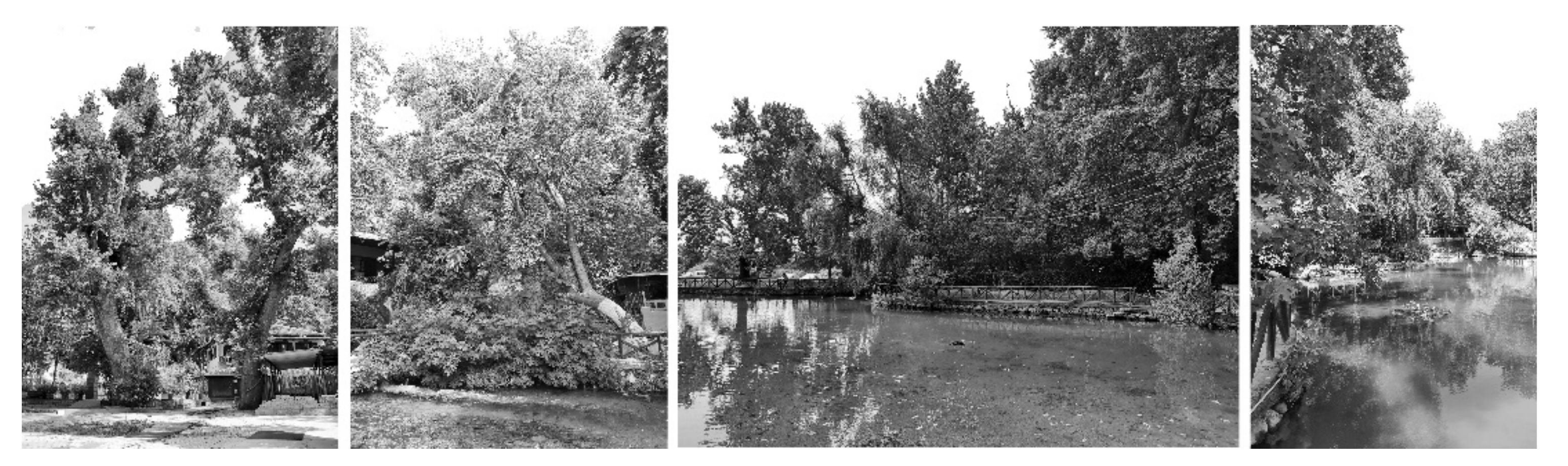
3.4. The Case of Agios Ioannis in Serres
The case of Agios Ioannis is similar to the previous one, although dating back to the 17th century when, due to internal political and social changes, local elite groups emerging from trade activities gradually started to appear in the Ottoman empire. Such social alterations in the city of Serres apparently sought their spatial representation and ultimately chose to hold their gatherings and annual celebrations in public in a “mesire”, a place of natural beauty. This was the case of Agios Ioannis close to the city of Serres, which lies below a low chain of hills, crossed by a local stream, irrigating the fertile plains. This enchanting landscape was supplemented by old plane trees providing shadow for summer siestas and picnics around the adjacent small lake.
Such a landscape of high social importance seems to have provoked a legend, claiming the place as being one of Muslim and not of Christian heritage. According to their narrative of the founding of the city, the Muslims upon marching against it tied their horses onto seven sticks on the spot, which soon grew miraculously into the seven plane trees that dominate the landscape. This narration, however, apart from its miraculous character, contradicts geography and history in at least two ways [
14]. Firstly, the city could not be approached by the Ottoman forces from south-west, as in the legend, but only from the east, considering the geomorphological characteristics of the place. Secondly, the city was not founded by the Ottomans, but rather surrendered to them, judging from the lack of any mosque inside the old Byzantine fortification or at least, of a Muslim neighborhood on that spot in the early Ottoman period. It is, therefore, clear that the previous narration served as a political argument, in the effort of local Muslims to forge their own version of history and relate it to a place with a highly provocative name (of a Christian Saint). However, no mosque was erected there at that time, both due to the lack of public funds in the 17th century and also, most importantly, due to the shift of patronage forms from buildings to gardens. Within this context, the landscape of Agios Ioannis predominantly constitutes a ‘scenery’ for political gestures, through narratives of religious connotations.
If one considers the testimony of a local source of the early 17th century that this has been the place where Christian guild members were gathering to hold their meetings and celebrations, just like their Muslim counterparts have done in other mesire places around the city, then one can also trace a rivalry between the orthodox element of the town and the Muslims who, in fear of the change of the 17th century, felt threatened by the rise of the orthodox within the local ottoman society [
29]. As such, Agios Ioannis in Serres was not only a landscape of religious connotations but also of social ones. Here, the incorporation of a locality within the Ottoman power narrative is not “ordered” by the court in architectural terms but by the locals in terms of oral traditions and counter-narratives that introduce the spot to their “version” of the story and emphasize their role as rulers after their “conquest”. The social and political conditions in the 17th century may not have favored the erection of another mosque at a considerable distance from the city of Serres, but the shifts in landscape perception have allowed other kinds of narratives to penetrate the local Balkan landscapes. After the middle of the 17th century, when the ottoman society will witness the rise of a more bourgeois type of social class, the mentality towards nature will shift from the mystified imperial one to the more realistic notions of pleasure and “habitation”. In this sense, this particular case study highlights the radical changes that the 17th-century social transformation has brought upon the perception of landscape and its means of appropriation (
Figure 7).
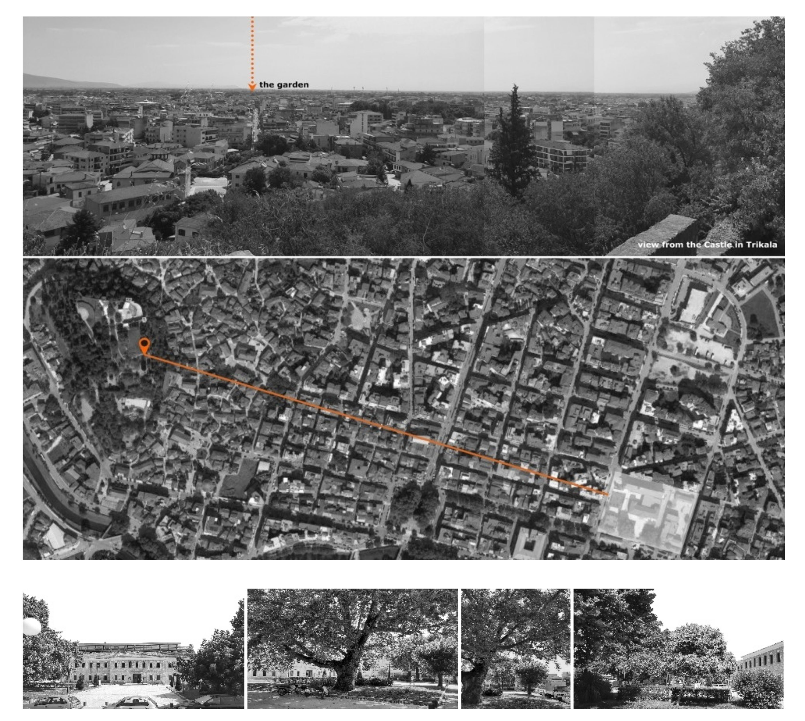
3.5. The Case of Trikala in Thessaly
The city of Trikala was a well-known and established center for the wider region of the southern Balkans during the Late Medieval Period. The Ottoman conquest of the city in the early 15th century had a massive impact on the city’s development which was expanded and soon adorned by illustrious Ottoman architectural elements. However, in this research, the case study in Trikala refers to a garden that used to exist along the route from Trikala to Larissa, in the eastern outskirts of the Ottoman city [
30]. Unfortunately, it does not survive today, however, we claim that it was situated on the grounds of what is now the city’s courthouse, based on two arguments. The first is that there is a tradition of royal ground to be later used by the Ottoman military-like in this case (the courthouse was an ex-Ottoman barrack). The second argument is that the location and size of the garden matches exactly the contemporary space around the courthouse. We know that this garden was a token of royal patronage by Suleiman II around 1691, right after the recapturing of Belgrade from the Austrians. In older days, on such an occasion a mosque complex would have been built but, in the late 17th century, a public garden was preferred, matching perfectly with the outdoor policy for major Ottoman royal gardens in Edirne, just a few years earlier [
31] (
Figure 8).
Although there are no particular references to the kind of flowers that would be cultivated in the garden, we assume that probably those would be roses, considering both their symbolic properties as a representation of divine and secular authority as well as the wide spread of their cultivation for financial purposes, since from these flowers, rose-water and rose-essence were exported, meeting the high demand and practices in the Ottoman society of those days. In addition to that, multiple political gestures were inscribed in this garden with the power of the Ottoman state being the most obvious one, since it was internally divided into 26 sections, a number matching the number of the Ottoman provinces in the Balkans back then. The garden also, marked the gradual integration of the modern concept of state, emerging in Europe at that time, since it was a cultivated fenced place. The new trends in agriculture and financial viability were also evident in this garden, should one take into account the selection of plants with significant financial value, able to support a garden on its own, unlike in the past when Ottoman architectural complexes were bestowed with agricultural land revenues to be maintained in the future. Moreover, the access of the public to the garden highlights the embracement by the royal house of the new gardening culture, prevailing in the Ottoman society those days, politically associated with a more realistic interpretation of nature “well-fitting” into the “constitutionalist” ideological trend of that time. Yet the Sultan was still considered as having the sole responsibility for the creation of a prosperous landscape for all of his subjects.
The selection of Trikala for the allocation of the garden also demonstrates the central political role of this city in the Empire, allocated on major trade routes of the southern Balkans, thus allowing the political and social connotations of the garden to be further spread. Such gardens are the forerunners of the great garden culture that would flourish in the next century in Istanbul and other places of the Empire and they constitute a remarkable shift in the Ottoman society’s perception of an enchanted landscape to a more comprehensive and natural one. This trend is also supplemented by the rise of Aristotelian studies in the Empire in the same period, a fact allowing wider cognitive interpretations for such royal gardening initiatives [
16]. Furthermore, such changes might be related to new political concepts emerging in Europe at the time, after the treaty of Westfall, in which the fixed boundaries of a state and its internal affairs are considered as inviolable. Such early modern state-like notions emphasize a unified and compact land territory with firm borders and excelled internal administration. The garden of Trikala and others across the Empire might have just embodied this new concept. Such an interpretation fits exceptionally into the policies and needs of the sultan at the time, when his role in the empire’s affairs was not as strong as before, if not challenged directly [
32]. In this context, the garden can be a means for the sultan to fulfil his new role as a guarantee of the unity of the state, supervising its internal administration. Once again, cognitive changes and political ideologies within the empire elite social groups have directly influenced spatial formations in a place that had a central political role.
3.6. The Case of the Park of Rodini in Rhodes
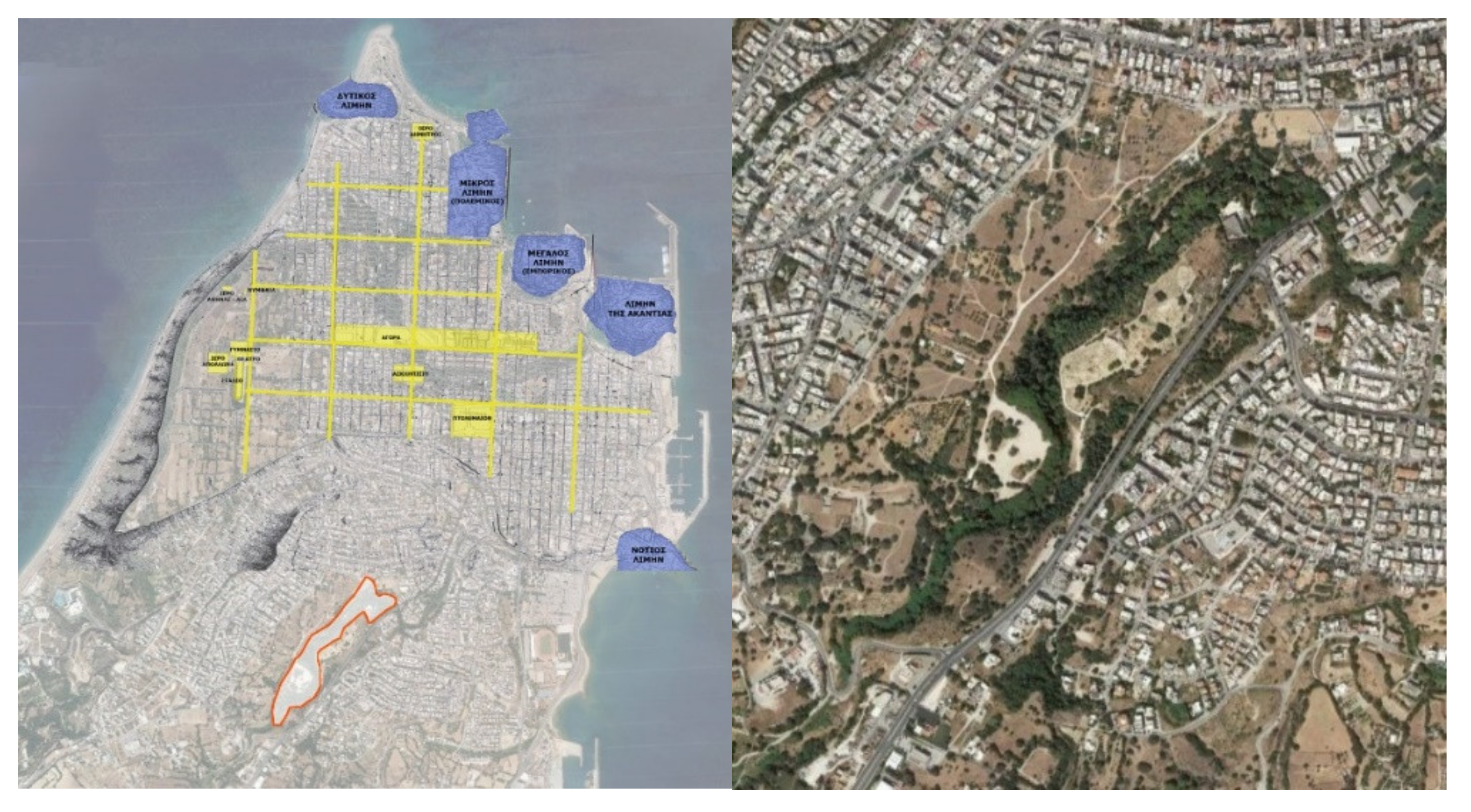
Allocated in the largest island of the Dodecanese complex, the city of Rhodes is a typical example of continuous habitation since the Neolithic period (5.000 B.C.), reaching its peak during the Bronze Ages due to powerful cultural connections with the Minoan Crete and mainland Greece. Due to its geographical position in a privileged area in the eastern Mediterranean, Rhodes has always had a vantage position on the trade routes between the west and the east, being at the same time, both a “host” to well-protected harbors and at the crossroads of cultural and commercial exchanges [
33].
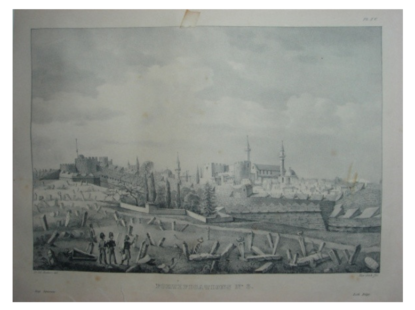
The ancient city of Rhodes was founded on the northernmost part of the island in 408 B.C. and its urban planning was based on the Hippodamian study of Rhodes, modelled on the respective one of Piraeus [
34]. The selection of the city’s location in the northern part of the island is based on geomorphological and commercial/economic criteria, since numerous trade maritime routes intersect at this point (connection of both the Black Sea and Northern Aegean Islands to Crete and Egypt as well as the Peloponnese to the coast of Asia Minor, Cyprus, and Syria), and at the same time, there are natural bays for the docking of ships. In addition to this, the stream of the Rodinios river, south of the urban complex, acts as a defensive trench while serving as a water source for the city’s supply. The famous for their era fortifications which enclosed the city of Rhodes, corresponded to specific defensive needs, which particularly increased in the period of the 4th century B.C., given the developments in the art of siege [
35] (
Figure 9). The city’s independence lasted until 164B.C. when Rhodes became a province of the Roman Empire. In the Byzantine times, Rhodes was an Episcopal see and a prominent military base. In the following centuries, the city shrunk in size, and new fortifications were built. In 1309, the island of Rhodes was sold to the Knights of the Order of Saint John of Jerusalem and for over two centuries (1309–1522), the island of Rhodes prospered under their rule as Knights invested their wealth in fortifying Rhodes. In 1522 the last Grand Master was forced to hand over the town to Sultan Suleiman the Magnificent after a six-month siege. The Ottomans remained on the island until 1912 when Rhodes was occupied by the Italians and during those centuries, the island lost its glory and international prestige, yet it retained its main financial role as a marketplace for agricultural products.
Focusing now on the Rodini area, one should take into account that this is probably the only site in the eastern Mediterranean basin that has been continuously inhabited since antiquity as a place of leisure with high aesthetic value in terms of landscape perception. The park of Rodini dates back to the creation of the city of Rhodes itself almost 2500 years ago and as such, it is considered one of the oldest parks in the world. The park marked a natural border between the city of Rhodes (the urban grid itself) and the necropolis, allocated at the southern part of the city where the natural surroundings (rich vegetation and water features) favored the creation of a place for leisure and recreation. The beauty of this place, an “earthly paradise”, constituted the perfect “scenery” for the allocation of the necropolis, allowing for both a strong connection to the deities of Hades and a passage to the world of the dead (
Figure 10). The inhabitants curved the natural concavities of the rocky landscape “embracing” the southern part of the city, with figures of divine properties, embossed decorations, and statues, attributing to the landscape of Rodini park high aesthetic values in conjunction with the sacred character of this particular landscape. In this sense, the park of Rodini is uniquely distinct for its sculptural decorative character from the other renowned parks of Alexandria or Antiochia, glorified for their elaborate design and rich vegetation [
17].
The park of Rodini was an ideal setting for philosophical schools, as indicated by the presence of the Oratory School of Aeschines, the famous orator and statesman of Athens where renowned orators such as Cicero and Julius Caesar studied [
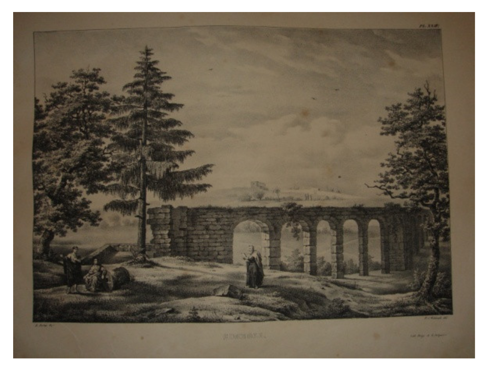
36]. In Roman times, new estates were built in the park of Rodini for the upper class, in search of a large place away from the urban congestion which would allow for the display of the political and financial wealth of this class. In the era of the Knights, the park of Rodini retained its role as a leisure park, hosting the estates of the Knights (similarly to the Roman times) and also, the Grand Master’s Estate, as testified in a letter by Pope John XII. Undoubtedly, the most significant element of this park, along with the existence of an aqueduct that fed the city of Rhodes based on the Hellenistic water pipe system, was the presence of a botanical garden whose plant species were used by the Knights for various disease treatments, similarly to the contemporary healing gardens.
In 1522, after the conquest of Rhodes by the Ottomans, the park of Rodini, a small valley with roses, shady plane trees, and water fountains, was still a public peri-urban garden designated for recreational activities. The Ottomans not only respected the character of this site but also, having been enchanted by the beauty of this “earthly paradise”, they enhanced its role as a park by rendering it a place for leisurely public walks (a “mesire”) along with a burial place for prominent people of the Ottoman society (a necropolis) [
37]. The Ottomans named the park “Zimboulli” from the Turkish word “Sümbüllu” which means an area covered by “cyclamens”, as this flower grew extensively in this park due to the microclimate and the soil particularities. The word “Zimboulli” could also bear the meaning of a junction (a confluence) as multiple water features met there (
Figure 11).
Taking into account its role throughout the centuries and under various authority rules, the park of Rodini has always been the focal point of the social and cultural activity on the island of Rhodes. Fully integrated into the daily life of the island’s inhabitants, the park maintained its role as a landscape of “escape” -a sanctuary for divine connections through nature. In general, it succeeded in incorporating various elements from different cultures and adopting all those cultural adjustments in its very own character, acting thus, as a palimpsest of landscape traditions.
4. Conclusions
This research requires a new perception of the landscape, shifting from the linear progression of history to the cyclical time of the sacred through symbols and repetitions, revealing a story of continuous (spiritual) revelation and cultural manifestations. The goal is to depict the “theology of nature” in which the Byzantine world, as well as Ottoman views, were grounded, highlighting the interconnections of space and world (and thus, social) order based on the cosmological and religious beliefs of those nations. For the Byzantines, as well as the Ottomans, nature was perceived as a system of symbols created by a divine power to facilitate communication with humanity. This interaction between “cosmic” and “sacred” as manifested into the landscape, reflected the emerging political ideologies, the financial power, and the imperial glory of the Ottomans (
Table 1).
The landscape experience embodied the multi-ethnic background of the Ottoman society, in accordance with the pre-existing cultural characteristics each region they conquered already bared. The extent to which this “symbiosis” was successfully functional or not was inscribed to the landscape through the form of intentional design interventions by the Ottomans. It is our belief that these landscape gestures constitute primarily political decisions with cultural implications, interlinking various Greek sites with a significant Ottoman background, yet waiting to be discovered.
As such, our proposal lies on the “smart” decision of interconnecting those sites through a virtual, digital route, guiding the user/visitor through landscapes of Hellenistic, Byzantine, and Ottoman inscriptions. This palimpsest of Eastern Mediterranean cultural landscapes will showcase the limitations taken into account in the decision-making process in regards to which traces of the past the Ottoman society chose to highlight, enhance, or eliminate. In any of those scenarios, the most significant element for this research is the reason for doing so, as we have already pinpointed the fact that this is, above all, a political act with cultural connotations.


