
Augmented Reality Storytelling Submerged. Dry Diving to a World War II Wreck at Ancient Phalasarna, Crete

1
Department of Media and Communication, University of Oslo, 0317 Oslo, Norway
2
Independent Researcher, Sydney 2086, Australia
3
Director of the Phalasarna Excavations, 73400 Kisamos, Greece
*
Author to whom correspondence should be addressed.
Heritage 2021, 4(4), 4647-4664; https://0-doi-org.brum.beds.ac.uk/10.3390/heritage4040256
Submission received: 23 October 2021
/
Revised: 2 December 2021
/
Accepted: 3 December 2021
/
Published: 11 December 2021
(This article belongs to the Special Issue Dive in Blue Growth – Protection and Promotion of Accessible Underwater Cultural Heritage Sites)
Abstract
:Underwater heritage and archaeology is, in general, limited to the few who have permission, and the means to actually dive on location and experience the submarine sites. Dry dive technologies such as Augmented Reality (AR) now offer unprecedented opportunity to change this situation. This paper explores the use of AR storytelling with regard to a World War II landing craft at Phalasarna, Greece. Tank Landing Craft A6 (TLC) was sunk by German aircraft while evacuating Allied troops from Crete in 1941. Its remains still lie just off the coast in a few metres of water. This project revolves around the development of a 3D–animation to make the site more accessible to those who cannot dive. By visually reconstructing the dramatic event of the craft’s final moments under German attack before it settled to the seabed, as well as the site’s present condition, visitors can experience and learn more about both the vessel itself and the historical context. The Indirect AR simulation contains two main modes: a dry dive reconstruction of the wreck as it looks today with detailed multimodal explanations based on historical and archaeological research, and an animation sequence that reconstructs the actual German attack on the ship. This article presents detailed descriptions of the site’s historical background, of the vessel and the design challenges involved in the production process of the app itself. Feedback provided by visitors who recently tested the AR simulation on location is also reported here.
1. Introduction
Location-based media in general and Augmented Reality (AR) in particular are changing the ways various audiences are able to experience and interact with archaeological artefacts, cultural heritage sites and historical events. The augmentation of the physical environment with digital multimodal and multimedia content is enriching the quality of visits to museums and sites, as well as providing added value in both indoor and outdoor settings. The technological mixing of the real and (virtual) digital augmentation render possible new formats of dissemination, narrative techniques and storytelling, on and off location. However, one domain or element, still remains relatively unexplored when it comes to AR: Many shipwrecks and other underwater cultural heritage locations continue to be inaccessible to the regular visitor or tourist for obvious reasons. Diving is still a certified activity limited to the few, while many wrecks and artefacts reside at depths or under conditions which do not allow for close encounters of the wet physical kind. This is where the recent advent of ‘dry diving’ can be of assistance.
The notion of ‘dry diving’ can signify various phenomena, for example preparation for diving sports conducted out of the water, or pressure training in hyperbaric chambers. However, in the context of underwater archaeology and underwater cultural heritage, ‘dry diving’ is related to the use of digital technology to access a site without performing a physical dive [1,2,3,4]. AR in the form of traditional mixed reality has previously been explored in actual diving situations with specialised equipment. Such ventures, however, require waterproof devices and special infrastructure to handle positioning in addition to overcoming access limitations related to regular diving as mentioned above [5].
The use of AR in dry diving sets the scene for new forms of storytelling and communication around cultural heritage by means of location–based media. In the following paper we present the design and discussion of an AR simulation illustrated by a dry dive to a wreck from World War II, Tank Landing Craft A6 sunk by German bombers during the Battle of Crete in 1941. The main research questions examined are: (a) To what extent is it possible to adapt the ‘dry dive’ experience on cultural heritage locations to established practices and results using applications of AR simulations? (b) In what different ways can these experiences be designed with regard to narrative structure and multimodal elements? (c) How can the shallow water site of the WWII wreck at Phalasarna be enhanced and placed in a more comprehensive historical context for visitors and researchers using AR both on and off site?
To answer these questions we first provide background to the Ancient Phalasarna site and its ongoing archaeological excavations, where, crucially, the WWII wreck forms an integral and an inseparable part of the history of the entire area. The paper then moves on to details of the development and the deployment of this WWII vessel, including also both the sinking event, its current condition and environmental and human impacts on the site. The next section describes the app, its technology, narrative structure and the main challenges associated with the design. In a reflections section, certain theoretical perspectives on access and adaptation of the documentary genre are outlined. Finally, we report on written feedback from the first users to test the AR situated simulation on location. The article concludes with the development team’s suggestions and plans for further research, additional testing of the application, and extended experimentation.
2. The Phalasarna Site
The archaeological site of Phalasarna, at times denoted with the spelling of Falasarna, is to be found in far western Crete, in the region of Chania, 60 km from the harbour town of the same name. In Greek, the name of both the ancient site and the modern village are written as Φαλάσαρνα. The ancient city-state was built upon the high cape Kastri, believed to have been originally an island, around the c. 8th–7th B.C. Its well–protected harbour was situated at the base of the cape between two bays that were most likely, at some point, connected (see Figure 1 below). The cape and the bays themselves were of strategic importance as they overlooked the western gateway to the Mediterranean from where shipping and the surrounding area, along with its approaches, as now, could be monitored [6] (p. 155).
Phalasarna was a maritime power attested to in ancient literary sources as being of considerable import. The main environs of the ancient city of Phalasarna covered a large area (c.1.5 × 0.5 km), with a certainty of further extension by satellite settlements. At the base of the cape around which the ancient Phalasarna expanded, large fortifications walls, with high remnants still extant, ran the length of the city. The city-state was well known for its superiority at sea and its skilful archers. Its workshops produced sculptures and vases equal to that of Athenian craftsmanship. A merchant’s house has partly been excavated at the foot of the acropolis, revealing imported trade goods from around the Mediterranean, particularly from ancient Cyrenaica (Libya) in north Africa. A winery and adjoining warehouses unearthed provide evidence of the production of various goods for export.
On-going excavations have uncovered not only ceramic vessels, but also coins, jewellery, sculpture and inscriptions, revealing a well-developed society with an established legal system. Many of these artefacts are on display in the museums of Kisamos and Chania.
As thus far excavated and reported, the Classical and Hellenistic city of Phalasarna represents the architectural features of a metropolis during these eras as well as exhibiting the unique structure of a virtually intact, walled harbour (see Figure 2 above) lifted en masse by later tectonic activities to an elevation some six and a half metres above the present sea level [7,8]. The blocking of the harbour in antiquity was undertaken by Roman forces in 67 B.C.E. at the behest of the Roman Senate. This was in response to continued Cretan piracy, certain of which originated from this harbour-city. The subsequent rapid silting, episodic tsunamis [9,10] of varying intensity and the complete, likely forced abandonment of the port and its surroundings from the time of the sealing of its waterway. This has preserved the integrity of structures in and around the harbour, providing significant architectural and structural elements indicative for these time periods.
Evidence of the Minoan period in the form of ceramics has also come to light in the excavated areas, as well as in the form of walls on the acropolis. The archaeological and geological investigations carried out to date reveal materials supporting the authenticity of both the site and its dating while both the ancient and the more modern team with the natural terrain to constitute an overall cultural and historical landscape, in other words a unique place with a long continuous and complex history [11,12].
The site of Phalasarna, both ancient and modern, contains evidence of physical relics of past use that cannot immediately convey to an audience their relationship with the natural surroundings. Yet, these remains can display their full meaning and significance if adequately presented, set within a context that is easily understood and, for the present purpose of ‘dry diving’, able to be experienced on various levels and within various contexts. Phalasarna was a harbour-city, established specifically to take advantage of the local geological landforms that provided both shelter and a starting point for construction of harbour facilities and the sea as an economic platform.
It was at this precise location in the early morning of 28 May 1941, as the Battle for Crete of 1941 moved violently towards its conclusion, that a British Royal Naval ship, the TLC A6, with its crew and wounded passengers, found refuge as likely many others had over the millennia. Unfortunately, this time the protection the skipper of the vessel sought for his charges was short-lived as spotter planes from the German Luftwaffe called in bombers to sink the craft as it sheltered adjacent to Phalasarna’s ancient harbour. The remains of the vessel still rest there in place on the sandy bottom in shallow water, a further reminder of continuing maritime nature and culture of the site and of Crete.
3. The A6 Vessel and Wrecksite
Lying in the remnants of the narrow desilting channel, cut through the rock more than 2000 years ago to assist in maintaining the harbour of ancient Phalasarna, is the sunken wreck of the British World War Two vessel (see Figure 3 below). The existence of the wreck is common knowledge around the area, and likely has been since the sinking. However, over time, any of the real stories behind the now rusting craft and its exploits were completely forgotten as eyewitnesses to the event gradually passed away.
Interest in the British ship and the surrounding circumstances resurfaced after Nike Marder, a professional diver and photographer correctly identified the wreck as some type of landing craft. From that point, archaeological survey and documentary research have resurrected the saga of this particular vessel and its heroic crew. In addition, the part played by the courageous Greek and Cretan people during the Mediterranean campaigns has been further revealed.
The Tank Landing Craft (TLC) Mk1 were secret, prototype vessels, constructed in the latter half of 1940 by the British for Combined Operations. Shipyards such as Vickers-Armstrong, Harland & Wolff and Hawthorn Leslie were tasked with the rapid production of the first order of twenty of the Mk1 type of the craft (see Figure 4 below). Churchill was keen to avoid another episode like Dunkirk where the retreating British armies had to leave behind all heavy equipment on the seashore:
On this same not infertile 6th of June, 1940, flushed with a sense of deliverance and the power to plan ahead, I began a long series of minutes in which the design and construction of tank-landing craft was ordered and steadily pressed.[13] (p. 207)
The British Prime Minister saw these new vessels as forming the central element for amphibious operations in the Mediterranean.
The crafts’ real, and often unexpected, battle capabilities had yet to be tested. A Sub-Lieutenant from the Royal Naval Volunteer Reserve (RNVR), or perhaps only a Royal Navy (RN) Boatswain, was to skipper these ‘experimental’ vessels into the struggle in the Middle East. In fact, other than the crews of the TLCs themselves, very few armed forces personnel had previously seen such vessels:
Indeed, not even aboard the flagship was there anyone who recognised them for what they were.[14] (p. 55)
The new TLCs were the largest vessels of the landing craft types at that time. They were able to operate under their own power across long distances (900 nautical miles) and could carry up to six medium-sized tanks or other heavy equipment. Built like a floating dock with sides, and two very powerful V8 engines, the craft were virtually unsinkable but were also very difficult to manoeuvre, even in the slightest of seas.
As 1940 drew to a close, Hitler’s attention focused more directly on his plans to invade Russia. However, his Italian ally Mussolini’s initial failure in the invasion of Greece [15] along with the Italians’ lack of success in the North African campaigns appear to have realigned Hitler’s interest towards Greece and the Mediterranean to limit British control in the area [16] (p. 469), [17,18,19]. Churchill’s new TLCs were to assist in securing the region.
The first Tank Landing Craft [20] arrived in Egypt on cargo transports from the UK in February of 1941 and immediately after reassembly took part in operations. The first five TLCs were sent from Alexandria to the besieged town of Tobruk in early April. Upon arrival, they were redirected to Suda Bay on Crete, where they were joined by two more hastily assembled TLCs sent directly from Alexandria. The TLCs were then prepared to assist in the evacuation of Greece.
Only weeks earlier, Commonwealth troops had been sent into Greece to deter Italian and German forces from invading [21]. However, the German assault proved too strong, and when the Greek military, after many hard-fought battles, could not continue, there was no option for the British but evacuation. The TLCs, with their carrying capacity of 900 men, uplifted troops from beaches to the ships waiting further offshore. Greek fishermen also assisted in the dangerous task of ferrying the exhausted troops [21].
In total, five TLCs were involved in this evacuation operation, codenamed Demon, yet only one of them (A6) made it back to Crete at the end of April. After the successes in mainland Greece, it made tactical sense for the Germans to advance southwards through the Eastern Mediterranean and onto Crete. Hitler issued Directive 28 on 25 April 1941 [22] and less than a month later, the Germans began their invasion of Crete with the deployment of huge numbers of paratroopers. This airborne assault [23] (pp. 205–206), [24] (p. 29) proved costly in terms of soldiers lost, yet it was ultimately successful [25]. Again, the Commonwealth troops were forced to evacuate.
By then, only two TLCs (A6 and A20) remained fully operational in Suda Bay and their skippers were ordered to make their way down to the southern coast of Crete to once again assist with evacuation [26]. Neither of them was to reach their destination, as both were sunk off the coast at the northwestern end of Crete [25].
Fortunately, none of the crew of the two TLCs were lost in the dive-bombing attacks that sent them to the bottom, but all were eventually taken prisoner by German troops after some being sheltered, at great risk, by many of the local villagers. The people of Crete continued their struggle against the occupation by Germany.
The last known mention of TLC A6 and its sister ship A20 (also now located [25]) comes from The Supplement to London Gazette in 1948, the information taken directly from the war diary of the Admiral of the Mediterranean Fleet, Andrew Cunningham:
Nothing is known of the fate of tank landing craft A6 and A20, and it is presumed that they were sunk by enemy air action on passage.[27]
A statement of losses circulated in 1946 listed the two TLCs only as lost somewhere in the Middle East, with location unknown. This situation remained unchanged for more than seventy years until the shipwreck lying adjacent to ancient Phalasarna was finally and definitively identified [25]. Up until that point visitors to the site, and even those who ventured into the water for a closer examination, had no idea about the wrecked vessel and the crucial contribution it made during the Greek and Cretan campaigns.
4. Site Conditions
Situated at an average depth of approximately three and a half metres, the wrecksite remains submerged at all times (see above Figure 5). The surrounding seabed has scattered rock outcrops and the water column enveloping the craft stays relatively calm and unaffected by current or direct wave action as the headland provides both shelter and protection. However, a westerly breeze may, at times, generate a slight swell over the site.
The wreck has settled on a reasonably level surface with a gradual increase in water depth towards the destroyed stern section. The underwater debris field was recorded at a maximum of 25 m. from east to west and 60 m. from north to south.
The Mediterranean is generally classed as an oligotrophic body of water as nutrients such as nitrates and phosphates tend to be scarce in the surface layers of the water column. At deeper levels, conditions more suitable for plant growth exist. Anthropogenic additions into surface layers may alter this balance in particular regions but the local hydrography of the wrecksite and the surrounding area do not appear to overly affected by eutrophication. Likely, as the wreck lies adjacent to an archaeological area, a lack of urban development means there is less risk of imbalance.
Additionally, although Tsimplis et al. [28] cite numerous causes for variations in salinity for regions within the Mediterranean basins, it appears the surface layers of specific Mediterranean water columns, those more isolated from river outflow and anthropogenic influence, maintain a static salinity, with a psu (practical salinity unit) falling somewhere between 38.5–39.0 [29] (p. 51). Thus, the wrecksite environment remains reasonably stable but has been greatly impacted upon since the wrecking event by another factor–salvage.
The existence of a ‘beached whale’, a ‘bonanza unexploited’ in such an accessible position motivated local people to gather what they could from the shipwreck as soon as was possible. Keep in mind that this was undertaken in time of war and resultant hardships. Eyewitness accounts also indicate that from the time of the sinking of the vessel, numerous salvage/retrieval forays or operations have taken place. These appear to have varied in their organisational structure and their intensity, from the snorkeling tourist through to the use of explosive charges and makeshift lifting apparatus. It is likely a majority of these salvage ventures were not witnessed and, for all episodes, no records exist. Any or all of these attempts have, and will continue to impact upon the site to various degrees.
5. Description of the App Design, the Dry Dive and the Challenges
The awareness and the understanding that an archaeological site is a complex, non-static artefact needs to be instilled in visitors to both the ancient city and the WWII wreck to ensure that any protection processes will be successful in the long term. Certainly, laws and penalties may assist over the short term in halting or impeding decay but constant vigilance and monitoring is not feasible in such an area. Being able to recognise the inherent values in the maintenance and the preservation of all historical aspects of Phalasarna would be a starting point with, at a later stage, this perception encompassing a realisation, to varying degrees, of the site’s cultural significance and importance. A site must not only visual entertain but impart information crucial to understanding the historical and cultural landscape confronting visitors. Thus, the stage is set for an innovative AR approach to provide an informative and educational dimension to a visit to Phalasarna.
Virtual and augmented Reality has, over the past two decades, increasingly been employed in relation to cultural heritage and archaeological sites [30], both on– and off–location [31,32]. The wreck of TLC A6 is particularly relevant in its connections to the AR research and development that has been conducted and used in the dissemination of results from the ancient Phalasarna excavations.
In 2015, after several years in the making, the Phalasarna AR app was published. It contained reconstructions of Ancient Phalasarna from 330 BC as well as the city’s destruction by the Romans in 67 BC [33]. The current version of the new Phalasarna 1941 AR application, developed at part of the Marebox EU–project, builds on experiences with the original Phalasarna app. Phalasarna 1941 will both supplement and complement the 2015 edition, linking in to provide a visitor to the site a complete overview and informative experience of the early, and the more recent history of this important archaeological site of Western Crete. Visitors of any age to the site will be able to use their own devices once the app has been downloaded. Little or no background knowledge is assumed on the part of user as the app provides an overview of the lead up to the demise of the craft thus setting the vessel within the overall context of the archaeological site. The proposed Visitor’s Centre to be developed on the Phalasarna site will function in conjunction with the educational experience provided by the new application.
The Phalasarna 1941 application is a situated simulation, that is a form of AR known as Indirect Augmented Reality [34,35]. Instead of a mixed reality solution combining a live video feed with a 3D graphics layer, Indirect AR uses the full screen for the digital environment and the mixing takes place between the screen and the surrounding physical environment. The Phalasarna 1941 app utilizes the Sitsim AR platform that has been in development since 2008. It is based on the Unity engine. The current test version of the app is running on a number of iPhones and iPads but will eventually be available also for Android and iOS devices as free downloads.
Due to the use of the Indirect AR approach for Phalasarna 1941, it is a simple matter to export a WebGL version of the application which can then run in any HTML5 enabled browser. During the development phases we have successfully used this WebGL-solution for testing, appraisal and for design discussions. A WebGL version of the complete application will be made available to allow for off-site access once all testing has been completed. It, as yet, remains to be seen how an online web version should be best designed when compared to the on-site AR installation.
For the Marebox EU–project two underwater archaeological sites are being explored using AR: The A6 wreck at Phalasarna and the Alonnisos Peristera ancient shipwreck located in the Sporades archipelago in the Aegean Sea. Due to practical considerations surrounding the current pandemic we chose to first focus on the Phalasarna case. At Phalasarna we had already established local representation, together with digital terrain models. In addition, as the distance from wreck to shore is not great, a particular set of logistics immediately became less challenging for the initial design. It thus made sense to work on the TLC case first and then build on those experiences gained from this when moving to the Alonnisos Peristera site and the use of the AR approach there.
The Phalasarna 1941 test app is divided into three parts, each of which presents different aspects of the story, various forms of engagement, as well as changing modes of representation. The dry dive forms the central section framed by an introductory walk and followed by a reconstruction of the historical event in late May of 1941.
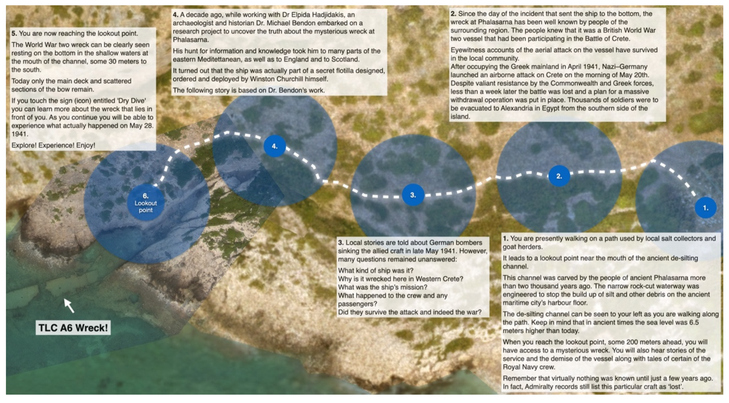
- Approaching the wreck by foot:
The A6 wreck is located some 200m. from the fenced central area of the Ancient Phalasarna site. Here, on the western edge at the mouth of the desilting channel is a small flat area in the otherwise rocky and undulating terrain. A footpath, easily visible and formed by local salt collectors and shepherds, leads up to, and beyond, this vantage point (see Figure 6 and Figure 7). This position allows an unimpeded view of the wreck as it rests on the seabed some two to three metres below the surface (see Figure 3 above). Walking to the lookout point takes an average of three to five minutes with the app launched at the marked beginning of the path. The visitor is then presented with information on how to use the app, via an introductory sequence of slides. The app then changes into Indirect AR mode [34] where a dynamic 3D–model of the terrain and seabed, based on drone photogrammetry, is presented on the screen and continually updated as the visitor moves ahead. The path is marked in the digital model to make it easier to find the way. While the visitor is traversing the path a five–part audio voice–over provides background information with each audio section triggered by positioning and synchronised with the walking speed of the individual user. The audio information also comes in a documentary mode of presentation which follows through all three parts of the simulation tying them together seamlessly. After the visitor arrives at the vantage point the dry dive can then be activated by means of a positioned hypertext link.
Challenges encountered in the design of this part stemmed mainly from the integration of information types. Audio narration, not written text and path marking, is used to help the visitors find their way. By doing this the user is able to avoid any physical obstacles making it easier to walk safely along the actual path. Another hurdle presented in the adjusting and fine-tuning the length and number of voiceover segments as well as deciding upon their position and linking to trigger zones. In this narrative design, the physical approach to the wreck site also functions as the verbal introduction to the main topic, thus the temporal dimension of storytelling is mapped by spatial movement of the user [35].
- 2.
- The dry dive sequence:
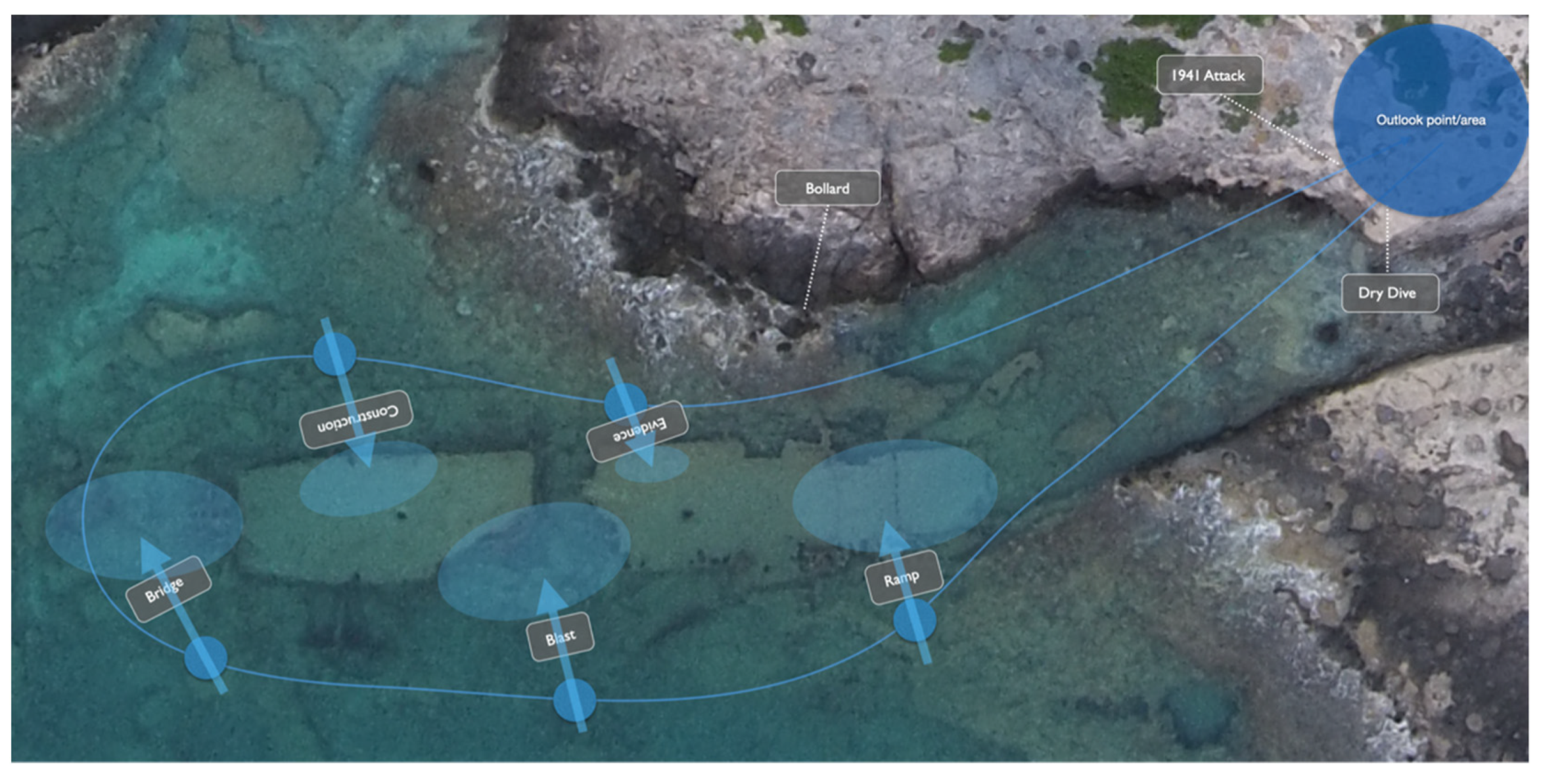
Arriving at the lookout point well introduced to the background of the wreck, the central experience begins. The visitor activates the signpost (hypertext link) and the virtual camera inside the 3D–environment moves down to the wreck and away from the user’s physical position. In this mode, GPS positioning is overruled by movements along a predefined path, while other sensors remain operational making it possible to pan and tilt the camera/perspective as the user pleases (see Figure 8). The route encircles the extant parts of the wreck and includes five stops with each presenting information on various aspects of the vessel: the ramp mechanism; indications of where the 500 kg Stuka bomb hit the vessel; the demolished bridge; the tank deck construction; and material evidence crucial to the identification of the ship. These multimodal information posts employ different combinations of information types: 3D–models and –animations, photos and illustrations and various forms of audio (voice–over, real recorded sounds and sound effects). WebGL–formatted high resolution 3D scans of artefacts from the wreck are accessed online via the app’s internal web browser which supports the 3DHOP heritage online presenter [36].
In the dry dive sequence several major design challenges were encountered. Among these; the recreation of the visual and auditory experience of being underwater and the best-suited method to handle the combination of a predefined route and the free movement of the (virtual) camera (tilt and pan).
Perception of depth underwater is similar to that experienced on land. In painting one can create an illusion of depth or distance using what Leonardo da Vinci called ‘aerial perspective’, that is reducing colour and contrast relative to the distance from the viewer, for example often depicting distant mountains in a low contrast blue tone. Underwater the visibility is more limited than in the atmosphere but it follows a similar pattern. In the sea, the colour spectrum moves from high detail up close, via green to blue and to dark blue in the distance, depending on the lighting conditions. At Phalasarna, the wreck and surrounding seabed is covered in an ochre-coloured seaweed which dominates the visual milieu nearby the diver. In the dry dive sequence, an attempt was made to simulate these actual conditions with further work undertaken to improve them. Diving close to the surface as is necessary on this shallow-water wreck means that reflaction with reflection of the seabed (and the wreck) will be more dominant in the upper part of the visual field. This effect also had to be simulated within the app.
Auditory perception also differs underwater and the decision needed to be made as to which type of sounds reproduced within the application would be affected by the underwater conditions. The real soundtrack from a dive around the wreck proved to be the most suitable. For the reconstruction of the ramp’s dynamics the addition of submarine effects to authentic audio clips from similar mechanisms added a further touch of realism. However, keeping the voice–over completely ‘dry’ provided continuity with the voice–over track from the introductory walk.
In digital media compositions it is important to leave the user in control, at least to some extent, with this always a difficult balance. In the dry dive, the predefined path is combined with free camera movement which raised the question of how to ensure the visitor is looking in the right direction? In the dry dive sequence, the solution was to place the hypertext link between the stop position of the virtual camera and the relevant part of the wreck. The user’s attention is also directed to crucial elements upon ‘reaching’ the stops on the dive by the use of various markers (see Figure 9).
- 3.
- Reconstruction of the 1941 attack.
As the virtual camera returns to the user’s actual position at the lookout point the dry dive comes to an end. At the same time, a new hypertext link appears with the option to activate a reconstruction of the events that led to the sinking of TLC A6.
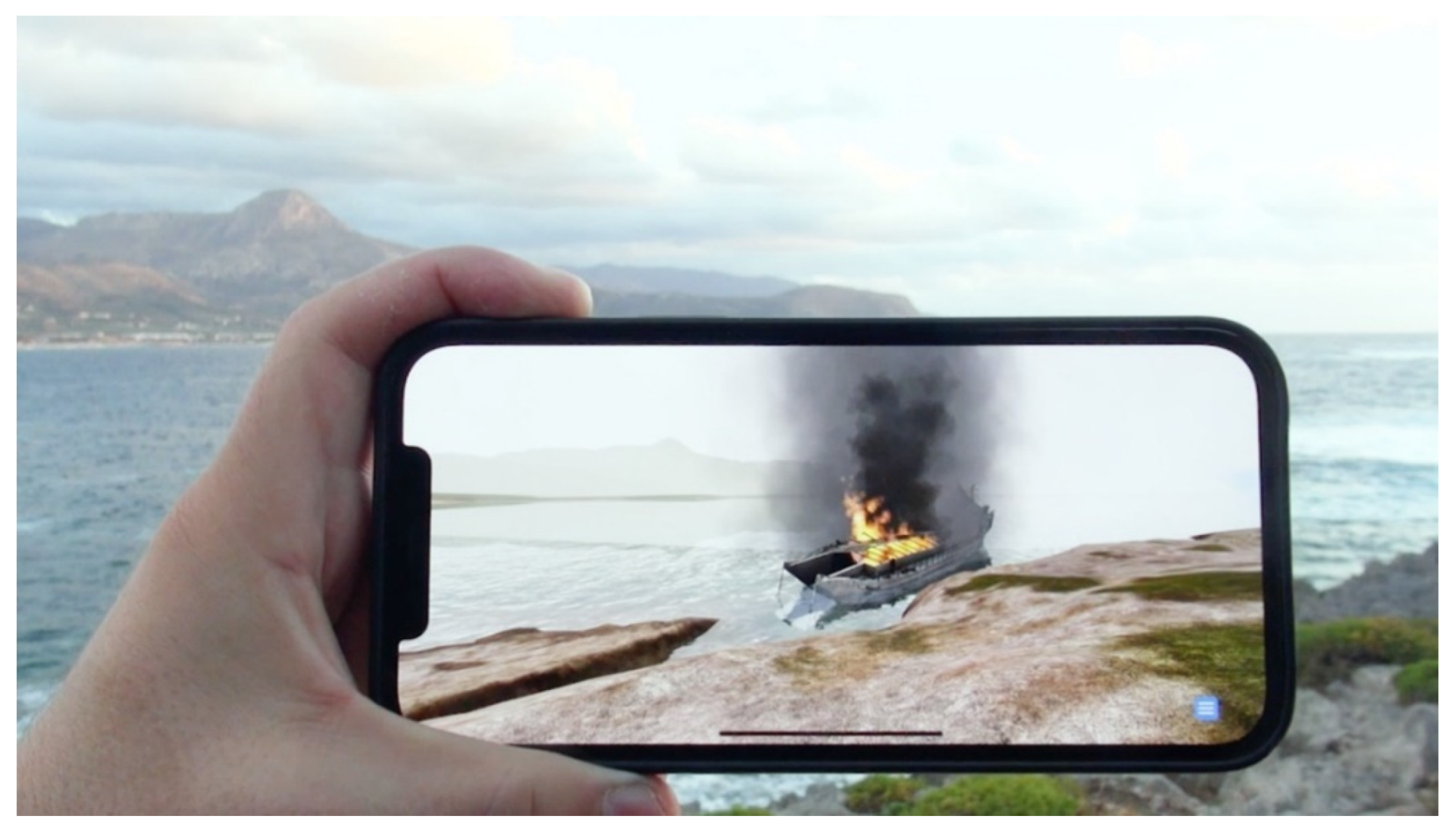
The reconstruction starts with black and white wartime footage narrating main events during the Battle of Crete. This serves as an introduction to the military situation while at the same time providing a context for the fate of the landing craft. Still in the World War II documentary mode, the story moves from the general theatre of war to the story of A6. Digitally generated video sequences are included following the historical footage and show the TLC at sea during the night and finally arriving at Phalasarna in the early morning. The black and white documentary introduction then cuts to the virtual camera controlled by the user/visitor before the presentation turns into full screen colour mode. The voice–over continues and narrates background information as the user experiences the Messerschmitt spotter plane twice attacking the vessel before leaving the area (see Figure 10 below). The crew and soldiers disembark to hide in caves and under protruding rocks in the desilting channel fearing the imminent return of the Luftwaffe (see Figure 11 below). After a few hours, two Junker 87 Stuka bombers arrive to eventually cripple and sink the vessel (see Figure 12 below).
While this reconstruction of the historical event is unfolding, it is possible for the user to pause the temporal sequence with a two–finger touch which then allows access to background information about the situation as well as the involved objects and parties. In this way, the user may return to the historical reconstruction with a more informed knowledge of the situation, hopefully enriching the overall experience.
The main design challenge in this section of the application was to create an engaging narrative of the historical event that could help the visitor understand and experience the process and uncertainty leading up to the wrecking event. We aimed to bring out a level of contrast between Phalasarna of today with its beautiful beaches, impressive archeological sites and relaxed way of life attracting an increasing number of visitors and tourists, and the brutal drama of World War II. Displaying the attack and sinking of the ship then serves as a dramatic climax to the story. In the narrative design, we were able to further develop and implement certain storytelling devices already experimented with in earlier productions [37,38].
6. Reflections: Accessibility, AR and the Documentary Genre
Although perhaps not immediately obvious, an underpinning of the ‘dry diving’ technology put into practice at the wreck site at Phalasarna, is to better preserve the archaeological remains. An article by Sperry [39] bemoans the decreasing opportunities to excavate underwater sites, yet whether or not this is actually the case, he does introduce a term of interest for site management and presentation, “the in situ culture” [39] (p. 24). This approach is judged by some to be the paramount approach to conservation of underwater heritage sites [40]. In the undertaking of the present archaeological research of the Tank Landing Craft, a ‘non-disturbance’ approach was utilised. This means that only measurements, photographs and videos were taken, with no excavation or collection of materials involved in the overall process—the central artefact and its archaeological context remain in situ.
Likely, at times, many readers have previously picked up inconsistencies associated with the assessment of significance when dealing with artefacts of underwater cultural heritage. There is a strong possibility that much of this ‘variation’ is due to what may be termed a sense of ‘intangibility’ felt by particular people associated in the overall process of decision–making and management. The ideas, the concepts, and the stated aims may be well understood but the management, preservation and presentation to visitors does not seem as pressing perhaps due to a lack of a ‘physical’ presence. This idea can be further extended to another group of stakeholders, the interested visitors.
Underwater heritage sites are, for the most part, “limited access spaces” and an example of Foucault’s [41] heterotopias, where to actually visit the site you must fulfil a selection of certain criteria. Shallow underwater sites require a level of snorkeling skill while deeper sites cannot be visited without possession of a diving certification. In addition, particular sites may have specific rules and regulations further limiting visitation. Most individuals do not possess the necessary qualifications to have first-hand access, receiving and relying on information provided and ‘filtered’ through to them via any number of different avenues.
The fact that this wreck is located close to shore and in shallow water yet remained virtually unknown and completely unidentified by many thousands of visitors to the site clearly indicates a pressing need for an educational innovation. Research into possible documentation relating any of episodes surrounding the Greek and Cretan campaigns revealed little or no mention of these particular craft. At that stage, officially classed as ‘minor war vessels’, they entered theatres of war without either wireless communication or charts although tellingly both of these ‘wartime necessities’ were issued soon after the calamity of Greece and Crete. This means, for the very first time, the background of the vessel type itself as well as its involvement in the Mediterranean campaigns of 1941 is accessible to the visitor. Now a stop at Phalasarna will offer a visual and informative experience of the entire history of the site and the inhabitants of the region, both ancient and modern rather than just isolated snippets of information from selected temporal dimensions.
In the Phalasarna 1941 app the use of the documentary genre as a rhetorical starting point provided a way to tie the various parts together. The voice–over mode is used throughout the simulation in order to create not only unity but also continuity and consistency in a shifting multimodal experience. In this way, genre knowledge as contained in the documentary serves as a topos for discovering and exploring new methods and modes of meaning making, with AR as a vehicle for invention and innovation in digital storytelling [42,43].
7. Testing and User Evaluation
The making of the Phalasarna 1941 test–application employs a combination of methodologies: We put into practice a humanities–informed media design method, as referred to above, where, for instance, adaptation of an element from the documentary film genre, the non–diegetic voice–over, was repurposed when exploring the storytelling potentials of AR in Cultural Heritage. We also utilized a more traditional user testing on location with visitors to the site.
The first round of testing was conducted in June 2021. However, the attempt encountered severe unforeseen hardware limitations. At that time Crete was experiencing heat wave conditions, with the onsite temperatures remaining at, on average, 37 degrees Celsius during much of the day. This caused the iPads and iPhones to overheat reducing brightness to 50% thus making the screen events practically invisible in the strong sunlight. When another attempt was made in October, a fall storm with heavy rain and strong winds hit the area. Despite these setbacks though we managed to accomplish initial tests and evaluations with the assistance of six visitors. These incidents are also a stark reminder that working outdoors with such media is fraught, and appropriate planning and countermeasures must be in place.
The visitors were each given a short introduction to the application and the testing process. A representative from the development team followed the visitors through the whole session to assist and to answer questions if problems arose. After the testing of the app itself, the user was given a written questionnaire to complete. A series of questions were posed regarding the general experience of using the app, the sound quality during the dry dive sequence and the historical reconstruction of the attack, as well as the adaptation of documentary film elements.
Asked about the immediate experience of the simulation and overall impressions, the evaluations were, in general, very positive. The app was described as a powerful new experience. One respondent commented: “This simulation was a great experience indeed. It helped me understand what standing on this historic ground really means”. Negative aspects tended towards more detailed aspects, such as the female voice–over being too little engaged in what is depicted as an exciting story, the strong sunlight as opposed to the limited brightness of the screen, and the low resolution of the terrain model during the walk to the lookout point. Most of these can very simply be improved.
In the design process we were uncertain how to shape the acoustic image during the dry dive. We were unsure at first whether to use real sound from a video recording of a dive around the wreck or to instead include more conventional effects that would likely be recognised from computer games and fiction film? We decided to opt for real sound from an actual dive but added sound effects for the animations of details such as that of the operation of the ramp mechanism. These sounds were drawn from similar equipment in use but manipulated somewhat to simulate the underwater conditions. The voice–over was left unaltered. All of the participants found the acoustic renderings during the dry dive added most positively to the overall experience: “It sounded like I was diving”. “The sound effects used in the reconstruction helped give life to what once was”. “Very positive!”.
This was also the case with the reconstruction of the historical events of 1941. The stereo sound strongly increased the user’s experience of the reconnaissance flyby of the fighter plane and of the Stuka bomber attacks. For some testers the sound actually helped identify the position of the planes before the attacks, while others spoke of not being able identify from which direction the Germans were approaching. However, this was not perceived or mentioned as negative. In fact, one respondent commented that not knowing the direction of approach added to the terror of Stuka bombing. Not being able to pinpoint the position early in the dive made the experience more in line with a real Stuka attack, with the actual apprehension of the danger rapidly descending being something often told in personal stories from the campaigns of 1941. This was a response we had not anticipated and shows that even unintended and unexpected effects may turn out as a positive addition to the experience.
The adaptation of documentary film elements such as the voice–over was also well received by the test users. The design team was particularly concerned about how the voice–over could unify the various modes of the simulation. When asked about the unmarked transition from documentary film mode to AR mode during the reconstruction of the historical event the feedback was generally very positive: “It was like stepping into a new world. I enjoyed it as the video documentary was not too long, but it excited me when I was able to also look around in AR mode”. “Very impressive … a new experience”. “It worked together very well”. One respondent commented that they did not immediately notice the transition, but added that the change in modality was not confusing or distracting from the overall experience.
8. Conclusions and Further Research
As was mentioned earlier, we conduct user testing and evaluation of both prototype and published application in order to continually improve the usability of the Indirect Augmented Reality platform. User evaluation will be central to any future alterations while additional professional advice will guide enhancement of underwater sequences and augmented experiences within the app. The number of visitors to the site of Phalasarna, and indeed to Crete, vary greatly throughout the year with the inclement weather of a Cretan winter keeping all but the most intrepid and hardy traveller from exploring all archaeological sites the island has to offer. Summer sees the peak of tourists to the area, and although for some, the archaeological offerings of Phalasarna may be of secondary importance, once testing has finished, promotion of the app locally and further afield will prove an appealing drawcard.
Place, as a fusion of space, time and experience, provides an endless array of possibilities for varied individual and/or group interaction and interpretation. With the application of ‘dry diving’ technology, visitors to the site will now be equipped to venture into and explore another aspect and chapter of the history and the crucial importance of Phalasarna.
The general approaches and aims of ‘dry diving’, as has been illustrated here by the example of the World War Two Tank Landing Craft at Phalasarna, are to provide information, and more crucially visual access, not readily available to most audiences.
Scant documentary evidence concerning the wreck at Phalasarna is extant, and none of this is accessible in a digital format as yet. Research into those limited sources held at the National Archives, Kew and the University of Glasgow Archives in the UK has allowed the construction of a broad context in which to place both the central artefact, the wreck, and the developments that led up to the wrecking event in late May of 1941 [25].
Additionally, the research into the vessel itself provided an almost unique opportunity to interact with eyewitnesses to actual circumstances. Two older local people who witnessed not only the wrecking of the craft but also the occupation of Crete by the Germans were able to tell their stories and have their recollections permanently recorded as part of the investigation. An incredible ’chance’ discovery was meeting with the actual British skipper of the vessel at the time of its sinking and whose memories of those days of the Mediterranean campaigns provided details long since forgotten or discarded [25]. By incorporating the ‘lived experiences’ of these witnesses we were able to add a further dimension to the structure of the overall story and we are now able to present to visitors and researchers an ‘immersive educational experience’.
Phalasarna, its culture and its heritage, has for many thousands of years revolved around its inhabitants and their relationship with the sea, that is a maritime culture. Any number of social or economic aspects have centered on the interaction of the people with their seaside environment. Wealth or poverty, feast or famine, danger or security all have ebbed and flowed throughout the site’s history so often dependent on the ocean.
Phalasarna’s peoples plied the Western Mediterranean for over three hundred years to trade as far afield as mainland Greece, North Africa, Palestine, Sicily and Italy. Still today, the ongoing excavations of the ancient site add further evidence to the story of a glorious past of a great maritime nation from the 4th century B.C..
Then, in an attempt to avoid destruction or capture at the hands of the invading German forces during the Battle of Crete, John Digby Sutton, the skipper of the British TLC sought protection in a section of the harbour of ancient Phalasarna. It is highly unlikely that he, his crew or his passengers realised it, but on that day in 1941 another chapter in the lengthy maritime saga of Phalasarna was written. And today, still further chapters are being added by the local people and visitors to the modern-day village.
Author Contributions
Conceptualization G.L., M.B and E.H.-M.; historical background and archaeology M.B. and E.H.-M.; technology, testing and design G.L.; writing—original draft preparation, G.L., M.B. and E.H.-M.; writing—review and editing, G.L., M.B. and E.H.-M.; visualization, G.L. All authors have read and agreed to the published version of the manuscript.
Funding
This research was partially funded by the Marebox Project (Creative Europe Programme under EACEA 06/2019 call “Bridging culture and audiovisual content through digital”, grant no. 614735), and the BitFROST Infrastructure Network at the University of Oslo.
Institutional Review Board Statement
Not applicable.
Informed Consent Statement
Informed consent was obtained from all subjects involved in the study.
Data Availability Statement
Not applicable.
Acknowledgments
Thanks to Tag of Joy: Šarūnas Ledas, Zilvinas Ledas, Zorian Ivanec, Vikte Normantaite & Jatužis Laurynas, for their skillful contributions with 3D-modelling, -animation, implementation and programming. Thanks to Espen Johnsen Bøe and the students at MEVIT3810 for valuable 3D contributions and editorial work. Thanks also to Nike Marder for excellent photos of the wrecksite and the ship’s clock; and to Michael Marder for his invaluable input during the writing of this article.
Conflicts of Interest
The authors declare no conflict of interest.
References
- Bruno, F.; Lagudi, A.; Ritacco, G.; Agrafiotis, P.; Skarlatos, D.; Čejka, J.; Kouril, P.; Liarokapis, F.; Philpin-Briscoe, O.; Poullis, C.; et al. Development and integration of digital technologies addressed to raise awareness and access to European underwater cultural heritage. An overview of the H2020 i-MARECULTURE project. In OCEANS 2017-Aberdeen; IEEE: Piscataway, NJ, USA, 2017; pp. 1–10. [Google Scholar]
- Malliri, A.; Siountri, K.; Skondras, E.; Vergados, D.D.; Anagnostopoulos, C.-N. The Enhancement of Underwater Cultural Heritage Assets Using Augmented Reality (AR). ISPRS-International Archives of the Photogrammetry. Remote Sens. Spat. Inf. Sci. 2019, XLII-2/W10, 119–125. [Google Scholar] [CrossRef] [Green Version]
- Chapman, P.; Conte, G.; Drap, P.; Gambogi, P.; Gauch, F.; Hanke, K.; Long, L.; Loureiro, V.; Papini, O.; Pascoal, A.; et al. Venus, Virtual Exploration of Underwater Sites. Proceeding of Joint Event CIPA/VAST/EG/Euro-Med. 2006. Available online: https://www.researchgate.net/publication/236155256_VENUS_Virtual_ExploratioN_of_Underwater_Sites (accessed on 29 November 2021).
- Bruno, F.; Lagudi, A.; Muzzupappa, M.; Lupia, M.; Cario, G.; Barbieri, L.; Passaro, S.; Saggiomo, R. Project VISAS: Virtual and augmented exploitation of submerged archaeological sites-overview and first results. Mar. Technol. Soc. J. 2016, 50, 119–129. [Google Scholar] [CrossRef]
- Čejka, J.; Zsíros, A.; Liarokapis, F. A hybrid augmented reality guide for underwater cultural heritage sites. Pers. Ubiquitous Comput. 2020, 24, 815–828. [Google Scholar] [CrossRef]
- Hadjidaki, E. The Roman destruction of Phalasarna. BAR Int. Ser. 2001, 940, 155–166. [Google Scholar]
- Dermitzakis, M. Recent tectonic movement and old strandlines along the coasts of Crete. Bull. Geol. Soc. 1973, 10, 48–64. [Google Scholar]
- Papadopolous, G.A. A Seismic History of Crete; Ocelotos Publications: Athens, Greece, 2011. [Google Scholar]
- Hadjidaki, E. The Classical and Hellenistic Harbor of Phalasarna in Western Crete; Unpublished Dissertation, University of California: Santa Barbara, CA, USA, 1988. [Google Scholar]
- Hadjidaki, E. Preliminary Report of Excavation at the Harbor of Phalasarna in West Crete. Am. J. Archaeol. 1988, 92, 463–479. [Google Scholar] [CrossRef]
- Pirazzoli, P.A.; Ausseil-Badie, J.; Giresse, P.; Hadjidaki, E.; Arnold, M. Historical Environmental Changes at Phalasarna Harbor, West Crete. Geoarchaeology 1992, 7, 371–392. [Google Scholar] [CrossRef]
- Dominey-Howes, D.; Dawson, A.; Smith, D. Late Holocene Coastal Tectonics at Falasarna, Western Crete: A Sedimentary Study; Iain, I., Vita-Finzi, C., Eds.; Geological Society, London, Special Publications: London, UK, 1998; pp. 343–352. [Google Scholar]
- Churchill, W. Their Finest Hour; Six Vols; Casselll: London, UK, 1949. [Google Scholar]
- Heckstall-Smith, A.; Baillie-Grohman, V.A. Greek Tragedy ’41; Anthony Blond: London, UK, 1961. [Google Scholar]
- Supplement to the London Gazette Number 37638, 3/7/46. p. 3423. Available online: https://www.thegazette.co.uk/London/issue/37638/supplement/3425 (accessed on 10 December 2021).
- Irving, D. Churchill’s War: The Struggle for Power; Arrow Books: London, UK, 1989. [Google Scholar]
- Kriegstagebuch (War Diary) Oberkommandos der Wehrmacht (Armed Forces High Command), 25/10/40. https://www.awm.gov.au/collection/LIB6034 (accessed on 10 December 2021).
- Kriegstagebuch (War Diary) Oberkommandos der Wehrmacht (Armed Forces High Command), 28/10/40. https://www.awm.gov.au/collection/LIB6034 (accessed on 10 December 2021).
- Kriegstagebuch (War Diary) Seekriegsleitung (Naval Command), 25/10/40. https://www.deutsche-digitale-bibliothek.de/item/TH3AX2FPDN67GO72MZ2FXTEEAPVSJKBP (accessed on 10 December 2021).
- University of Glasgow Archives, Glasgow UK, USC 3/13/66. (USC–Records of Alexander Stephens Shipyards). (Unpublished). https://archiveshub.jisc.ac.uk/glaas/archives/04bc9000-879a-3ebb-b6d7-1a490357563b?terms=Alexander%20Stephens%20.
- The National Archives, Kew UK, AIR 2/7935. (AIR–Air Ministry & Royal Air Force Records). (Unpublished). https://discovery.nationalarchives.gov.uk/details/r/C2637307.
- Führerdirektive 28, 25/4/41. Available online: https://ww2db.com/doc.php?q=326 (accessed on 10 December 2021).
- Ansel, W. Hitler and the Middle Sea; Duke University Press: Durham, NC, USA, 1972. [Google Scholar]
- Dobiasch, S. Gebirgsjäger auf Kreta; Wilhelm-Limpert-Verlag: Berlin, Germany, 1942. [Google Scholar]
- Bendon, M.J. The Forgotten Flotilla-The Craft of Heroes: Greece, Crete & North. Africa 1941; Ligare Printers: Sydney, Australia, 2014. [Google Scholar]
- The National Archives, Kew UK, ADM 199/810. (ADM–Records for Admiralty, Naval Forces & Related Bodies). (Unpublished). https://discovery.nationalarchives.gov.uk/details/r/C4121166.
- Supplement to the London Gazette, Number 38293, 24/5/48. p.3118. Available online: https://www.thegazette.co.uk/London/issue/38296/supplement/3118 (accessed on 10 December 2021).
- Tsimplis, M.; Zervakis, V.; Josey, S.; Peneva, E.; Struglia, M.V.; Stanev, E.; Lionello, P.; Malanotte-Rizzoli, P.; Artale, V.; Theocharis, A.; et al. Changes in the oceanography of the Mediterranean Sea and their link to climate variability. In Mediterranean Climate Variability; Lionello, P., Malanotte-Rizzoli, P., Boscolo, R., Eds.; Elsevier: Amsterdam, The Netherlands, 2006; Volume 4. [Google Scholar]
- Tomczak, M.; Godfrey, J.S. Regional Oceanograaphy: An Introduction; Elsevier: Amsterdam, The Netherlands, 1994. [Google Scholar]
- Bekele, M.; Pierdicca, R.; Frontoni, E.; Malinverni, E.S.; Gain, J. A Survey of Augmented, Virtual, and Mixed Reality for Cultural Heritage. J. Comput. Cult. Herit. 2018, 11, 1–36. [Google Scholar] [CrossRef]
- Vlahakis, V.; Karigiannis, J.; Tsotros, M.; Gounaris, M.; Almeida, L.; Stricker, D.; Gleue, T.; Christou, I.T.; Carlucci, R.; Ioannidis, N. Archeoguide: First results of an augmented reality, mobile computing system in cultural heritage sites. In Proceedings of the 2001 Conference on Virtual Reality, Archeology, and Cultural Heritage, Glyfada, Greece, 28–30 November 2001; pp. 131–140. [Google Scholar]
- Bolter, J.D.; Engberg, M.; Freeman, C.; Liestøl, G.; MacIntyre, B. The Acropolis on the Immersive Web. J. Media Innov. 2021, 7, 41–51. [Google Scholar] [CrossRef]
- Liestøl, G.; Hadjidaki, E. Quasi–Mixed Reality in Digital Cultural Heritage. Combining 3D Reconstructions with Real Structures on Location—The Case of Ancient Phalasarna. In Digital Cultural Heritage; Kremers, H., Ed.; Springer Nature: Cham, Switzerland, 2019; pp. 423–432. [Google Scholar] [CrossRef]
- Wither, J.; Tsai, Y.-T.; Azuma, R. Indirect Augmented Reality. Comput. Graph. 2011, 35, 810–822. [Google Scholar] [CrossRef]
- Liestøl, G. Situated Simulations between Virtual Reality and Mobile Augmented Reality: Designing a Narrative Space. In Handbook of Augmented Reality; Furht, B., Ed.; Springer: Berlin/Heidelberg, Germany, 2011. [Google Scholar]
- Potenziani, M.; Callieri, M.; Dellepiane, M.; Corsini, M.; Ponchio, F.; Scopigno, R. 3DHOP: 3D Heritage Online Presenter. In Computers & Graphics; Elsevier: Amsterdam, The Netherlands, 2015; Volume 52, pp. 129–141. ISSN 0097-8493. [Google Scholar] [CrossRef]
- Liestøl, G. Story and Storage–Narrative Theory as a Tool for Creativity in Augmented Reality Storytelling. In Virtual Creativity; Intellect Ltd. Article. English language; Intellect Books: Bristol, UK, 2018; Volume 8, Number 1; pp. 75–89. [Google Scholar] [CrossRef]
- Liestøl, G. Augmented Reality Storytelling. Narrative Design and Reconstruction of a Historical Event in situ. Int. J. Interact. Mob. Technol. 2019, 13, 196–206. [Google Scholar] [CrossRef] [Green Version]
- Sperry, J. More than meets the eyes? Archaeology underwater, technology, and interpretation. Public Archaeol. 2009, 8, 20–34. [Google Scholar] [CrossRef]
- Davidde, B. Underwater archaeological parks: A new perspective and a challenge for conservation—The Italian panorama. Int. J. Naut. Archaeol. 2002, 31, 83–88. [Google Scholar]
- Foucault, M. Of other spaces. Diacritics 1986, 16, 22–27. [Google Scholar] [CrossRef] [Green Version]
- McKeon, R. The Uses of Rhetoric in a Technological Age: Architectonic Productive Arts. In Selected Writings of Richard McKeon. Culture, Education and the Arts; McKeon, Z.K., Swenson, W.G., Eds.; University of Chicago Press: Chicago, IL, USA, 1998; Volume 2, pp. 197–216. [Google Scholar]
- Liestøl, G. Topics of Innovation. Towards a Method of Invention and Innovation in Digital Media Design. In Media Innovations. A Multidisciplinary Study of Change; Storsul, T., Krumsvik, A.H., Eds.; Nordicom: Gothenburg, Sweden, 2013; pp. 61–74. [Google Scholar]
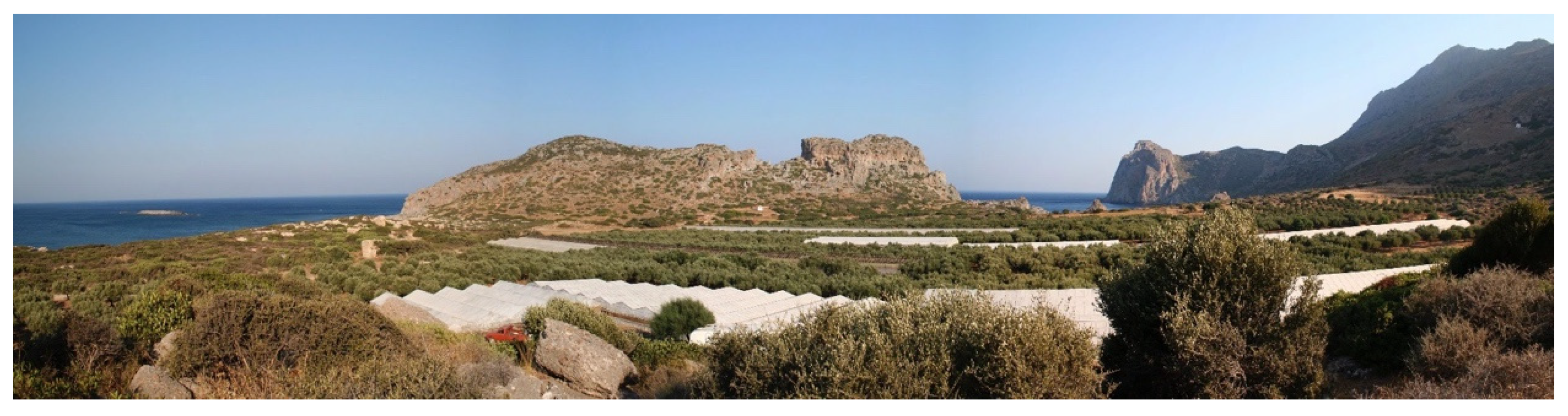
Figure 1.
An overview of the site and situation of Ancient Phalasarna-modern greenhouses in foreground.
Figure 1.
An overview of the site and situation of Ancient Phalasarna-modern greenhouses in foreground.

Figure 2.
A section of the quay of the ancient harbour of Phalasarna.

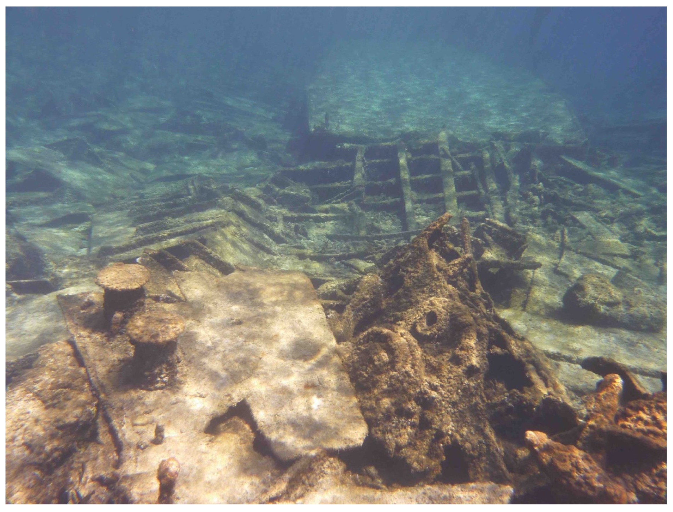
Figure 3.
The remains of TLC A6 lie just below the surface, bow edged into the ancient channel.

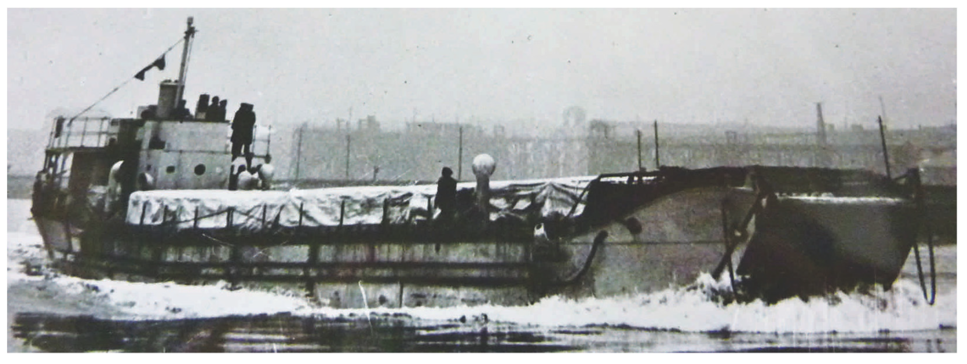
Figure 4.
A TLC in England prior to shipment to the Middle East.

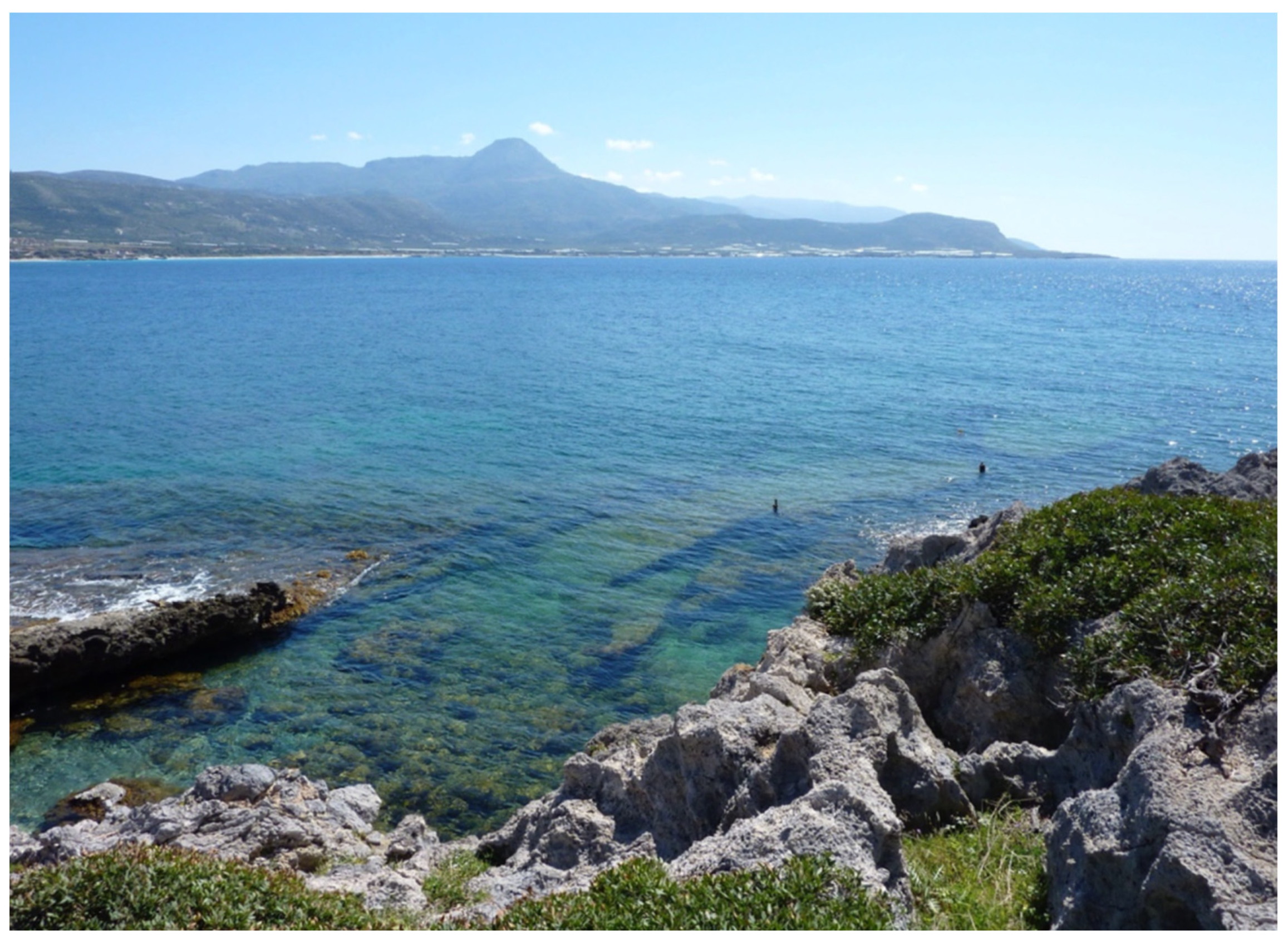
Figure 5.
The A6 wreck seen from the south.

Figure 6.
Visitors use the app itself to find the way to the vantage point while they are informed by audio commentary about the app and its subject matter.
Figure 6.
Visitors use the app itself to find the way to the vantage point while they are informed by audio commentary about the app and its subject matter.

Figure 7.
Map showing the path and the triggered positions (or zones) for the verbal content of the various voice–over parts.
Figure 7.
Map showing the path and the triggered positions (or zones) for the verbal content of the various voice–over parts.

Figure 8.
The blue line shows the predefined movement of the virtual camera around the wreck. The arrows at each stop indicate the optimal user/diver perspective and orientation at each stop. The first information stop ‘Ramp’ is shown in Figure 9 as a screenshot from the app demonstrating the virtual camera position.

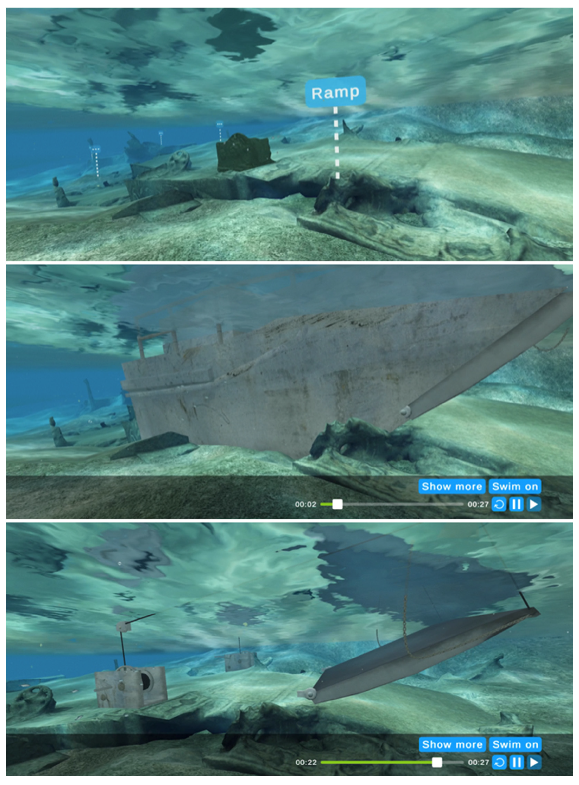
Figure 9.
First stop during the dry dive is the bow section. After activating the positioned hypertext line ‘Ramp’, the reconstructed bow section becomes visible to indicate the context of the original design. As the vertical sides of the hull disappears, the main mechanism and the ramp remain to show how the ramp was operated. A voice–over explains the main aspects of the animation.

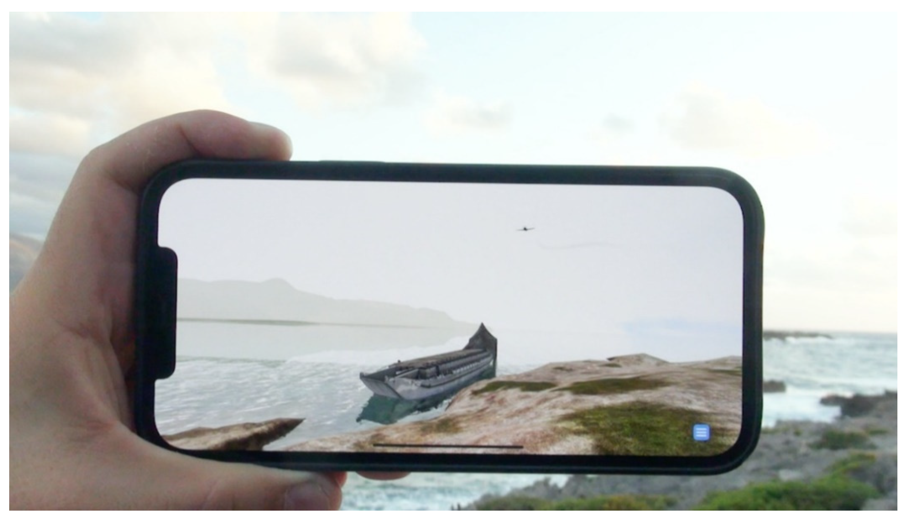
Figure 10.
A Messerschmitt fighter plane has just launched a machine gun salvo at TLC A6 from the south and is ascending. The user must move the device to follow the plane’s movement and actions. Consequently, the user controls the camera in this type of AR documentary.
Figure 10.
A Messerschmitt fighter plane has just launched a machine gun salvo at TLC A6 from the south and is ascending. The user must move the device to follow the plane’s movement and actions. Consequently, the user controls the camera in this type of AR documentary.

Figure 11.
The 500 kg Stuka bomb has just hit close to the petrol tanks on starboard side and the fire is spreading.
Figure 11.
The 500 kg Stuka bomb has just hit close to the petrol tanks on starboard side and the fire is spreading.

Figure 12.
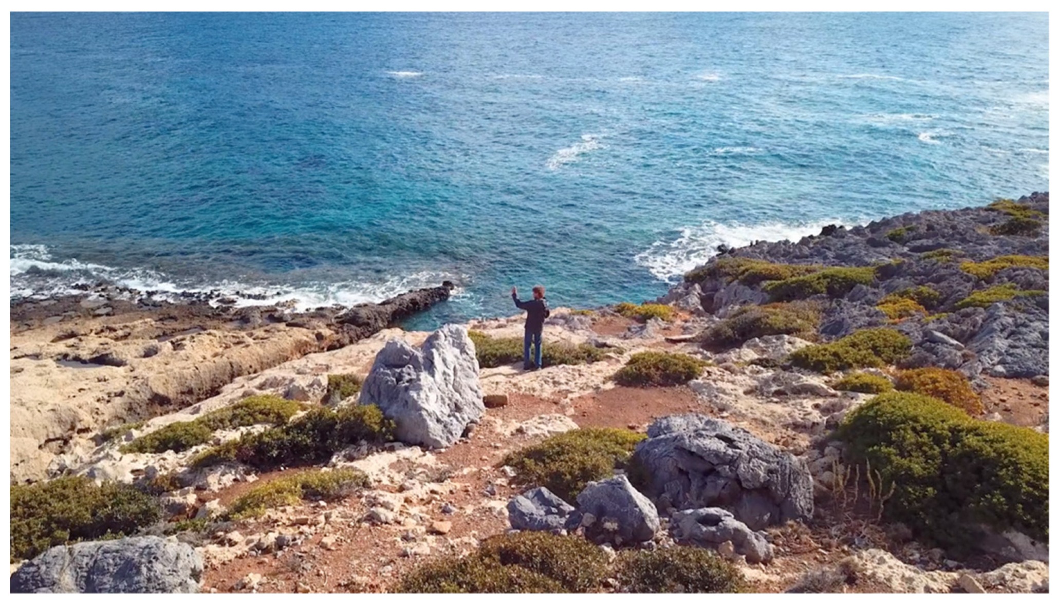
A visitor is exploring the test version of the app at the vista point overlooking the wreck. When activating the dry dive and the 1941 reconstruction there is no need for the user to walk around in the rocky terrain, only tilt and pan the device, and turn the body accordingly, to achieve the best possible acoustic and visual experience.
Figure 12.
A visitor is exploring the test version of the app at the vista point overlooking the wreck. When activating the dry dive and the 1941 reconstruction there is no need for the user to walk around in the rocky terrain, only tilt and pan the device, and turn the body accordingly, to achieve the best possible acoustic and visual experience.

Publisher’s Note: MDPI stays neutral with regard to jurisdictional claims in published maps and institutional affiliations. |
© 2021 by the authors. Licensee MDPI, Basel, Switzerland. This article is an open access article distributed under the terms and conditions of the Creative Commons Attribution (CC BY) license (https://creativecommons.org/licenses/by/4.0/).
Share and Cite
MDPI and ACS Style
Liestøl, G.; Bendon, M.; Hadjidaki-Marder, E. Augmented Reality Storytelling Submerged. Dry Diving to a World War II Wreck at Ancient Phalasarna, Crete. Heritage 2021, 4, 4647-4664. https://0-doi-org.brum.beds.ac.uk/10.3390/heritage4040256
AMA Style
Liestøl G, Bendon M, Hadjidaki-Marder E. Augmented Reality Storytelling Submerged. Dry Diving to a World War II Wreck at Ancient Phalasarna, Crete. Heritage. 2021; 4(4):4647-4664. https://0-doi-org.brum.beds.ac.uk/10.3390/heritage4040256
Chicago/Turabian StyleLiestøl, Gunnar, Michael Bendon, and Elpida Hadjidaki-Marder. 2021. "Augmented Reality Storytelling Submerged. Dry Diving to a World War II Wreck at Ancient Phalasarna, Crete" Heritage 4, no. 4: 4647-4664. https://0-doi-org.brum.beds.ac.uk/10.3390/heritage4040256